FESR Fondo Europeo di Sviluppo Regionale DESTINATION
|
|
|
- Aubrie Perry
- 8 years ago
- Views:
Transcription
1 DESTINATION DangErous transport To New preventive Instruments An integrated solution to monitor Dangerous Goods Transport (DGT) assuring human and environmental protection Antonello Navarretta Mariuccia Actis Dato CSI Piemonte Milena Orso Giacone Regione Piemonte

2 DESTINATION - DangErous transport To New preventive Instruments Program: IT-CH Operational Programme for Trans-frontier Cooperation funded by European Regional Development Fund Budget: Partner : RP Environment Dir. (leader) Transport Dir. Civil Protection Dir. RL Environment Dir. Civil Protection Dir. BZ Civil and Fire Protection Dir. VdA Civil and Fire Protection Dir. Canton Ticino Environment Dir. Technical Partner: CSI Piemonte 5T S.r.l. Lombardia Informatica S.p.A. Politecnico di Milano - Mobility & Transports Lab Timeline (Beg-End): 1/4/ /03/2014

3 DESTINATION objectives contribute to inter-regional road accident prevention, real-time DGT monitoring and more efficient emergency management PREVENTIVE SAFETY ACTIVE SAFETY PASSIVE SAFETY Accident prevention, environmental, transport, territorial & emergency planning Real-time monitoring, alerts management Emergency management intervention time reduction intervention effectiveness enhancement

4 DESTINATION Actions Arranging a monitoring network for detecting the transit of DGT: fixed monitoring GATES, located in most critical areas on-board units (OBU) placed on DGT vehicles Definition a highly detailed risk analysis model for land DGT GPS partners GeoDB OBU Risk analysis implementation of a shared DSS (SIIG) Gate
")
5 GATES Monitoring network 7 road/motorway network operators involved agreements signed until 2018! 1 gate Ti 8 gate BZ 1 gate VdA 8 gate RL OBU 6 gate RP 5 DGT companies involved and 100 continuously tracked vehicles (ENI fleet)

6 Risk analysis model for land DGT Road network ADR substances classification R Dest DGT accident scenarios Targets ( P ( P ( Fp E S ( C ))) ) ( P ) is i ADR, ij sc, ijk = Ri = i j k m m ikm km ff ikm i P, 1 D human environmental,

7 Standard Elaborations Risk analysis - elaborations available for all users referred to standard temporal and weather conditions effective risk assessment Custom Elaborations available for advanced users allow change (by amplifying or mitigating) of some parameter s values introduction of correction factors taking into account time-dynamics (day/night rather than holiday/weekday) or weather specific conditions (rain/snow/fog) effective risk assessment Simulations available only for specialist users allow edit of additional targets (e.g. presence of a shopping center, or a hospital) or manual enter of new values for specific parameters potential risk assessment (simulate possible changes in the actual context)
 or manual enter of new values for specific parameters potential risk assessment (simulate possible changes in the")
8 DESTINATION SIIG a flexible DSS calculation of specific formula-branches specific execution criteria depending on chosen formula to be represented assessment of cumulate impact of multiple accident scenarios multi-lingual user interface

9 SIIG Elaboration results - synthetic view road-stretch 100 m road-stretch 1 Km raster 5 km processing resolution changes with map display scale default representation shows the overall social and environmental risk, adopting different color gradations on a qualitative basis

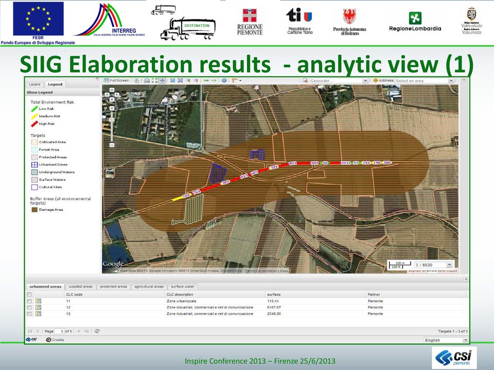
10 SIIG Elaboration results - analytic view (1)
11 SIIG Elaboration results - analytic view (2)

12 ESR ondo Europeo di Sviluppo Regionale DESTINATION Architectural solution SIIG GeoDB PARTNER WSO2 ESB GATE/OBU MANAGER Offline processes: ingestion of partners geodata used for DGT risk calculation (road stretchs & human/env. targets) and execution of necessary pre-processing elaborations Online processes: services exposed with standard OGC protocols (WMS) for base territorial data WSO2 Enterprise Service Bus (ESB) provides MOM (Message Oriented Middleware) functionalities
 for base territorial data WSO2 Enterprise Service Bus (ESB) provides MOM (Message Oriented Middleware)")
13 SIIG Component view Open Source solution INSPIRE compliant SDI OS Java enterprise application provides all developed by GeoSolutions, OGC for standard the collection, processing geo-spatial and publication of geospatial data services in for all acting as an accelerator real time on the fly for the base maps, Storage: calculation provides map tiling and PostgreSQL/Po requirements caching tile services stgis and any data database, for extraction MapStore: vector a data webgis Open Source framework management, developed by GeoSolutions, integrating and a shared and orchestrating GeoServer OGC file services system, for and metadata explorer functionalities raster data to browse the catalogues exposed management in CSW format

14 next steps (hopefully.) for SIIG functionalities On line functionalities matrices O/D for DGT based on OBU data re-routing f(info-mobility, R DGT ) risk standard elaboration results available for public as LOD Methodological improvements exploit monitoring network data (GATE & OBU) to improve risk analyis model, refining DGT input data (impacting on P ADR ) Batch processings facilitate production of input data for risk model, by automating their production starting from partner s geodata Mobile (app) functionalities DGT tracing with tablets/smartphones risk standard elaboration results re-routing damage assessment
 Batch processings facilitate production of input data for risk model, by automating their production starting from partner")
15 Thanks for your attention!

Regione Piemonte, Direzione Ambiente, Via Principe Amedeo 17, 10123 Torino, Italy, b
 A publication of CHEMICAL ENGINEERING TRANSACTIONS VOL. 26, 2012 Guest Editors: Valerio Cozzani, Eddy De Rademaeker Copyright 2012, AIDIC Servizi S.r.l., ISBN 978-88-95608-17-4; ISSN 1974-9791 The Italian
Standardized data sharing through an open-source Spatial Data Infrastructure: the Afromaison project
 Standardized data sharing through an open-source Spatial Data Infrastructure: the Afromaison project Yaniss Guigoz - University of Geneva/GRID-Geneva 1 EcoARM2ERA and AFROMAISON Why Afromaison in this
http://opendata.comune.fi.it
 The Environmental Observation Web and its Service Applications within the Future Internet OPENDATA IN CITY OF FLORENCE Gianluca Vannuccini Head of the IT Infrastructure Development Office IT Department
The technical infrastructure for mobile applications and INSPIRE compliant web services 29/10/2014. Jacques Roumilhac Rémy Giraud
 The technical infrastructure for mobile applications and INSPIRE compliant web services 29/10/2014 Jacques Roumilhac Rémy Giraud Context Evolution in our data distribution strategy, Open-data, WMO Information
What s new in Carmenta Server 4.2
 What s new in Carmenta Server 4.2 A complete solution for cost-effective visualisation and distribution of GIS data through web services Carmenta Server provides cost-effective technology for building
Italian Experiences in the Management of Dangerous Goods Transport
 Italian Experiences in the Management of Dangerous Goods Transport Luca Studer, Laboratory for Mobility and Transport, Politecnico di Milano, Dep. INDACO UdR DIS EasyWay 2008 Elena Caprile, Giovanna Marchionni,
GetLOD - Linked Open Data and Spatial Data Infrastructures
 GetLOD - Linked Open Data and Spatial Data Infrastructures W3C Linked Open Data LOD2014 Roma, 20-21 February 2014 Stefano Pezzi, Massimo Zotti, Giovanni Ciardi, Massimo Fustini Agenda Context Geoportal
Establishment of Spatial Data Infrastructure within the Environmental Sector in Slovak Republic
 EnviroInfo 2005 (Brno) Informatics for Environmental Protection - Networking Environmental Information Establishment of Spatial Data Infrastructure within the Environmental Sector in Slovak Republic Martin
The four (five) Sensors
 Sensors") The four (five) Sensors SWE based sensor integration in the German Indonesian Tsunami Early Warning and Mitigation System project (GITEWS) Rainer Häner, GeoForschungsZentrum Potsdam Content GITEWS: A short
The four (five) Sensors SWE based sensor integration in the German Indonesian Tsunami Early Warning and Mitigation System project (GITEWS) Rainer Häner, GeoForschungsZentrum Potsdam Content GITEWS: A short
Enabling embedded maps
 Enabling embedded maps Case: National geoportal of Finland Antti Rainio National Land Survey of Finland Trends: Web Services, Mapping Mashup, Open Source, Open Data Decentralised data s Service interfaces
A Hybrid Architecture for Mobile Geographical Data Acquisition and Validation Systems
 A Hybrid Architecture for Mobile Geographical Data Acquisition and Validation Systems Claudio Henrique Bogossian 1, Karine Reis Ferreira 1, Antônio Miguel Vieira Monteiro 1, Lúbia Vinhas 1 1 DPI Instituto
Keystone Image Management System
 Image management solutions for satellite and airborne sensors Overview The Keystone Image Management System offers solutions that archive, catalogue, process and deliver digital images from a vast number
Oklahoma s Open Source Spatial Data Clearinghouse: OKMaps
 Oklahoma s Open Source Spatial Data Clearinghouse: OKMaps Presented by: Mike Sharp State Geographic Information Coordinator Oklahoma Office of Geographic Information MAGIC 2014 Symposium April 28-May1,
CDI/THREDDS Interoperability: the SeaDataNet developments. P. Mazzetti 1,2, S. Nativi 1,2, 1. CNR-IMAA; 2. PIN-UNIFI
 CDI/THREDDS Interoperability: the SeaDataNet developments P. Mazzetti 1,2, S. Nativi 1,2, 1. CNR-IMAA; 2. PIN-UNIFI Outline Interoperability Issues in SeaDataNet A broker solution for CDI/THREDDS interoperability
European best practices in safe transport of dangerous material supported by GNSS
 2 nd GNSS Vulnerabilities and Solutions 2009 Conference, Baska, Croatia European best practices in safe transport of dangerous material supported by GNSS Gianmarco Baldini IPSC - JRC EC Antonella Di Fazio
GeoNetwork, The Open Source Solution for the interoperable management of geospatial metadata
 GeoNetwork, The Open Source Solution for the interoperable management of geospatial metadata Ing. Emanuele Tajariol, GeoSolutions Ing. Simone Giannecchini, GeoSolutions GeoSolutions GeoSolutions GeoNetwork
Green Move Web Viewer: critical issues and implementation
 GIT Geology and Information Technology 8a Riunione del Gruppo di Geologia informatica Sezione della Società Geologica Italiana Chiavenna, 17-19 giugno 2013 Polo Territoriale di Como Laboratorio di Geomatica
13 th EC GI & GIS Workshop WIN: A new OGC compliant SOA. for risk management. GMV, 2007 Property of GMV All rights reserved
 13 th EC GI & GIS Workshop WIN: A new OGC compliant SOA for risk management GMV, 2007 Property of GMV All rights reserved Content 1. Introduction 2. Objectives 3. Architecture and Model 4. Technical aspects
Centre for EcologicalNoosphere Studies NAS RA CENS
 SCOPES 2009-2012 Scientific Co-operation between Eastern Europe and Switzerland Accessing Armenian Environmental data through CENS Spatial Data Infrastructure Centre for EcologicalNoosphere Studies NAS
An Architectural Pattern for Designing Intelligent Enterprise Systems
 An Architectural Pattern for Designing Intelligent Enterprise Systems Eugenio Zimeo, Gianfranco Oliva, Fabio Baldi, Alfonso Caracciolo Department of Engineering University of Sannio Poste Italiane TI-RS
Data Integration Hub
 Data Integration Hub Data Integration Hub Provides a Better Way Actual Customer Point-to-Point Data Architecture Modern Data Integration Hub Masked Informatica Data Integration Hub Accelerate data projects
GeoMedia Product Update. Title of Presentation. Lorilie Barteski October 15, 2008 Edmonton, AB
 Product Update Title of Presentation Lorilie Barteski Edmonton, AB Know the audience poll Existing /Pro users Version 6.1 Version 6.0 Version 5.2 or earlier Existing WebMap users Version 6.1 Version 6.0
Smart Cities require Geospatial Data Providing services to citizens, enterprises, visitors...
 Cloud-based Spatial Data Infrastructures for Smart Cities Geospatial World Forum 2015 Hans Viehmann Product Manager EMEA ORACLE Corporation Smart Cities require Geospatial Data Providing services to citizens,
Integration of location based services for Field support in CRM systems
 Invited Contribution to GeoInformatics. Deadline September 15, 2001. Integration of location based services for Field support in CRM systems By P. Álvarez, J.A. Bañares, P.R. Muro-Medrano and F.J. Zarazaga
Processes of urban regionalization in Italy: a focus on mobility practices explained through mobile phone data in the Milan urban region
 Processes of urban regionalization in Italy: a focus on mobility practices explained through mobile phone data in the Milan urban region (DAStU, Politecnico di Milano) New «urban questions» and challenges
Master Data Management. Zahra Mansoori
 Master Data Management Zahra Mansoori 1 1. Preference 2 A critical question arises How do you get from a thousand points of data entry to a single view of the business? We are going to answer this question
IBM Software Group. IBM WebSphere Process Integration Technical Overview
 IBM Software Group IBM WebSphere Process Integration Technical Overview Business Flexibility Depends on IT Flexibility Today s IT architectures, arcane as they may be, are the biggest roadblocks most companies
Managing Adaptability in Heterogeneous Architectures through Performance Monitoring and Prediction
 Managing Adaptability in Heterogeneous Architectures through Performance Monitoring and Prediction Cristina Silvano cristina.silvano@polimi.it Politecnico di Milano HiPEAC CSW Athens 2014 Motivations System
Building a SDI for small countries the Portuguese example
 Building a SDI for small countries the Portuguese example Rui Pedro Julião Instituto Geográfico Português Deputy Director-General rpj@igeo.pt Abstract Portugal was one of the SDI pioneers in the beginning
Web-based Participatory GIS with data collection on the field: a prototype architecture in two and three dimensions
 8 Convegno Nazionale del Gruppo di Geologia Informatica Sezione della Società Geologica Italiana Chiavenna (SO), 17-19 giugno 2013 Ex Convento dei Cappuccini, Via Molinanca DICA Laboratorio di Geomatica
Web Map Service Architecture for Topographic Data in Finland
 Web Map Service Architecture for Topographic Data in Finland Teemu Sipilä National Land Survey of Finland Abstract. Since 2012 National Land Survey of Finland has been renewing its web map services and
Cloud-based Infrastructures. Serving INSPIRE needs
 Cloud-based Infrastructures Serving INSPIRE needs INSPIRE Conference 2014 Workshop Sessions Benoit BAURENS, AKKA Technologies (F) Claudio LUCCHESE, CNR (I) June 16th, 2014 This content by the InGeoCloudS
J12.5 AN EXAMPLE OF NEXTGEN WEATHER INFORMATION INTEGRATION AND MANAGEMENT
 J12.5 AN EXAMPLE OF NEXTGEN WEATHER INFORMATION INTEGRATION AND MANAGEMENT Russ Sinclair*, Tom Hicks, Carlos Felix, Keith Bourke Harris Corporation, Melbourne, Florida 1. INTRODUCTION In the NextGen era
GENESIS Employing Web Processing Services and Sensor Web Technology for Environmental Management
 GENESIS Employing Web Processing Services and Sensor Web Technology for Environmental Management Steven Smolders (1), Christian Alegre (2), Simone Gianfranceschi (3), Marc Gilles (4), Bernd Resch (5),
The ORIENTGATE data platform
 Seminar on Proposed and Revised set of indicators June 4-5, 2014 - Belgrade (Serbia) The ORIENTGATE data platform WP2, Action 2.4 Alessandra Nuzzo, Sandro Fiore, Giovanni Aloisio Scientific Computing and
GeoNetwork, The Open Source Solution for the interoperable management of geospatial metadata
 GeoNetwork, The Open Source Solution for the interoperable management of geospatial metadata Ing. Simone Giannecchini, GeoSolutions Ing. Emanuele Tajariol, GeoSolutions Outline GeoNetwork Introduction
Analysis of the Free GIS Software Applications in respect to INSPIRE services and OGC standards
 Analysis of the Free GIS Software Applications in respect to INSPIRE services and OGC standards Authors: Francesco D'Alesio Peter Hopfgartner Paolo Viskanic June 2011 Executive Summary This document analyses
Web 3D Service (W3DS) in Geoserver
 in Geoserver") Jorge Gustavo Rocha jgr@di.uminho.pt Nuno Carvalho Oliveira nmco51845@gmail.com VI Jornadas SIG Libre, Girona, March 23, 2012 1 Motivation and Introduction 2 3 4 5 Motivation Motivation and Introduction
Jorge Gustavo Rocha jgr@di.uminho.pt Nuno Carvalho Oliveira nmco51845@gmail.com VI Jornadas SIG Libre, Girona, March 23, 2012 1 Motivation and Introduction 2 3 4 5 Motivation Motivation and Introduction
From Geoportal to Spatial Data Service Platform. Jani Kylmäaho National Land Survey of Finland Development Centre
 From Geoportal to Spatial Data Service Platform Jani Kylmäaho National Land Survey of Finland Development Centre 29.6.2012 Introduction National Land Survey of Finland - 1900 employees Development Centre
Managing a Geographic Database From Mobile Devices Through OGC Web Services
 Managing a Geographic Database From Mobile Devices Through OGC Web Services Nieves R. Brisaboa 1, Miguel R. Luaces 1, Jose R. Parama 1, and Jose R. Viqueira 2 1 Database Laboratory, University of A Coruña,
Business Process Management Tampereen Teknillinen Yliopisto
 Business Process Management Tampereen Teknillinen Yliopisto 31.10.2007 Kimmo Kaskikallio IT Architect IBM Software Group IBM SOA 25.10.2007 Kimmo Kaskikallio IT Architect IBM Software Group Service Oriented
Shell CRM 2020. October 2014
 Shell CRM 2020 October 2014 MOST CONFIDENTIAL 2 2 THE SITE OF THE FUTURE RETAIL VISION Experience Role in Retail Strategy BEST FUELS RETAILER IN THE WORLD Accelerate Future Heartlands Defend and Grow the
GENASIS System Architecture
 GENASIS System Architecture On the way from environmental data repository towards research infrastructure Richard Hůlek, Jiří Jarkovský, Miroslav Kubásek, Jana Klánová, Jakub Gregor, Kateřina Šebková,
COSTE: a Web-Services Infrastructure Enabling Interoperability and Integration of Spatial and Traffic e-contents for European Regions
 COSTE: a Web-s Infrastructure Enabling Interoperability and Integration of Spatial and Traffic e-contents for European Regions Marco Boero Softeco Sismat SpA Italy Geographic Information: Motivation, problem
Software platforms for Collecting, Managing and Providing Monitoring Data for Food and Agricultural Products
 Software platforms for Collecting, Managing and Providing Monitoring Data for Food and Agricultural Products Japan Atomic Energy Agency Center for Computational Science and E-systems Hiroshi Takemiya Observed
How To Use Inspire For Eo Data Processing
 INSPIREd computing for EO Based Services Paolo MANUNTA 1, Giulio CERIOLA 1, Jens STUTTE 1 1 Planetek Italia s.r.l Via Massaua 12 I-70132 Bari E-Mail: manunta@planetek.it Workshop Big Data Roma, 26/11/2013
Developing Microsoft SharePoint Server 2013 Advanced Solutions MOC 20489
 Developing Microsoft SharePoint Server 2013 Advanced Solutions MOC 20489 Course Outline Module 1: Creating Robust and Efficient Apps for SharePoint In this module, you will review key aspects of the apps
EXPLORING AND SHARING GEOSPATIAL INFORMATION THROUGH MYGDI EXPLORER
 EXPLORING AND SHARING GEOSPATIAL INFORMATION THROUGH MYGDI EXPLORER Subashini Panchanathan Malaysian Centre For Geospatial Data Infrastructure ( MaCGDI ) Ministry of National Resources and Environment
Business Process Management Enabled by SOA
 Business Process Management Enabled by SOA Jyväskylä 8.5.2007 Kimmo Kaskikallio IT Architect IBM Software Brands Five middleware product lines designed to work together Service-Oriented Architecture (SOA)
From SOA to MOA: Transitioning from Service to Mobile Oriented Architectures
 From SOA to MOA: Transitioning from Service to Mobile Oriented Architectures OVERVIEW The evolution of enterprise mobility has brought with it new challenges to organizations attempting to enable the right
Craig McWilliams Craig Burrell. Bringing Smarter, Safer Transport to NZ
 Craig McWilliams Craig Burrell Bringing Smarter, Safer Transport to NZ World Class Transport. Smarter, Stronger, Safer. Bringing Smarter Safer Transport to NZ Craig Burrell Infrastructure Advisory Director
AN INTEGRATED SOLUTION FOR MANAGING EXPLORATION DATA
 www.wipro.com AN INTEGRATED SOLUTION FOR MANAGING EXPLORATION DATA Sandipan Chakraborti, Senior Architect ENU Table of Contents 03... Introduction 04... Lack of Holistic View 06... Figure 1: Conceptual
Implementation of information system to respond to a nuclear emergency affecting agriculture and food products - Case of Morocco
 Centre National de l énergie des sciences et techniques nucléaires (CNESTEN-Morocco) Implementation of information system to respond to a nuclear emergency affecting agriculture and food products - Case
SOA in the pan-canadian EHR
 SOA in the pan-canadian EHR Dennis Giokas Chief Technology Officer Solutions Products and Group Canada Health Infoway Inc. 1 Outline Infoway EHR Solution EHRS Blueprint Overview Oriented Architecture Business
Care Coordination and Realtime Risk Stratification
 Care Coordination and Realtime Risk Stratification Vish Anantraman MD, MS Chief Information Architect North Shore LIJ Health System North Shore LIJ Health System Current Healthcare Delivery is Fragmented
Oracle Service Bus: - When to use, where to use and when not to use
 Oracle Service Bus: - When to use, where to use and when not to use Session ID#: 244 Prepared by: Abhay Kumar Senior Consultant AST Corporation REMINDER Check in on the COLLABORATE mobile app Specialized.
Norwegian Satellite Earth Observation Database for Marine and Polar Research http://normap.nersc.no USE CASES
 Norwegian Satellite Earth Observation Database for Marine and Polar Research http://normap.nersc.no USE CASES The NORMAP Project team has prepared this document to present functionality of the NORMAP portal.
NTT DATA Big Data Reference Architecture Ver. 1.0
 NTT DATA Big Data Reference Architecture Ver. 1.0 Big Data Reference Architecture is a joint work of NTT DATA and EVERIS SPAIN, S.L.U. Table of Contents Chap.1 Advance of Big Data Utilization... 2 Chap.2
INTEROPERABLE IMAGE DATA ACCESS THROUGH ARCGIS SERVER
 INTEROPERABLE IMAGE DATA ACCESS THROUGH ARCGIS SERVER Qian Liu Environmental Systems Research Institute 380 New York Street Redlands, CA92373, U.S.A - qliu@esri.com KEY WORDS: OGC, Standard, Interoperability,
Developing a highly dynamic web application for a large bank using rules-based technology
 Developing a highly dynamic web application for a large bank using rules-based technology Part 1: Requirements and zooming in on a solution Part 2: Design and development Part 3: Conclusion and lessons
OPEN BIM and the future: BIM and GIS integration. Building the DND Real Property Spatial Data Framework
 OPEN BIM and the future: BIM and GIS integration Building the DND Real Property Spatial Data Framework Assistant Deputy Minister (Infrastructure & Environment) Director Real Property Planning Director
GeoNetwork User Manual
 GeoNetwork User Manual Release 2.10.4-0 GeoNetwork July 06, 2015 Contents 1 Preface 3 1.1 About this Project..................................... 3 1.2 License Information....................................
The paths of Via Regina geomatics for sustainable mobility
 FOSS4G Europe Bremen 15-17 July 2014 The paths of Via Regina geomatics for sustainable mobility Maria Antonia Brovelli (*), Massimiliano Cannata (**), Alba Lucchese (*), Marco Minghini (*), Marco Negretti
How To Use The Alabama Data Portal
 113 The Alabama Metadata Portal: http://portal.gsa.state.al.us By Philip T. Patterson Geological Survey of Alabama 420 Hackberry Lane P.O. Box 869999 Tuscaloosa, AL 35468-6999 Telephone: (205) 247-3611
Research Statement. 2. SMU tbank shall align to, and inform, SMU s Unified Banking Process Framework.
 Research Statement Alan Megargel School of Information Systems, Singapore Management University Tel: (65) 6808-5276; Email: alanmegargel@smu.edu.sg 29 th Jan 2015 Background During my years working in
COURSE CATALOGUE 2013/2014
 COURSE CATALOGUE 2013/2014 Field: COMPUTER SCIENCE Programme: Master s Degree Programme in Advanced Programming and Databases Length of studies: 2 years (4 semesters) Number of ECTS Credits: 120 +20 for
Potential Role of an Enterprise Service Bus (ESB) in Simulation
 in Simulation") Doug Stapleton IBM Australia Limited 28 Sydney Avenue, Forrest ACT 2603 AUSTRALIA dougstap@au1.ibm.com ABSTRACT This paper considers eight areas where an Enterprise Service Bus (ESB) can contribute to
Doug Stapleton IBM Australia Limited 28 Sydney Avenue, Forrest ACT 2603 AUSTRALIA dougstap@au1.ibm.com ABSTRACT This paper considers eight areas where an Enterprise Service Bus (ESB) can contribute to
Institute of Computational Modeling SB RAS
 Institute of Computational Modeling SB RAS ORGANIZATION OF ACCESS TO OBSERVATIONAL DATA USING WEB SERVICES FOR MONITORING SYSTEMS THE STATE OF THE ENVIRONMENT Kadochnikov Aleksey A. Russia, Krasnoyarsk
Microwatt to Megawatt - Transforming Edge to Data Centre Insights
 Security Level: Public Microwatt to Megawatt - Transforming Edge to Data Centre Insights Steve Langridge steve.langridge@huawei.com May 3, 2015 www.huawei.com Agenda HW Acceleration System thinking Big
How To Write An Inspire Directive
 INSPIRE Infrastructure for Spatial Information in Europe Detailed definitions on the INSPIRE Network Services Title Detailed definitions on the INSPIRE Network Services Creator Date 2005-07-22 Subject
Providing drivers with actionable intelligence can minimize accidents, reduce driver claims and increase your bottom line. Equip motorists with the
 Providing drivers with actionable intelligence can minimize accidents, reduce driver claims and increase your bottom line. Equip motorists with the ability to make informed decisions based on reliable,
Big Data Volume & velocity data management with ERDAS APOLLO. Alain Kabamba Hexagon Geospatial
 Big Data Volume & velocity data management with ERDAS APOLLO Alain Kabamba Hexagon Geospatial Intergraph is Part of the Hexagon Family Hexagon is dedicated to delivering actionable information through
COS AND LAND USE PLANNING: OPEN DATA TOWARDS PLANNING
 COS AND LAND USE PLANNING: OPEN DATA TOWARDS PLANNING EFFICIENCY R. Saraiva 1, B. M. Meneses 2, M. J. Vale 3, R. Reis 4 1) General Directorate for Territorial Development, Portugal rsaraiva@dgterritorio.pt
The use of Semantic Web Technologies in Spatial Decision Support Systems
 The use of Semantic Web Technologies in Spatial Decision Support Systems Adam Iwaniak Jaromar Łukowicz Iwona Kaczmarek Marek Strzelecki The INSPIRE Conference 2013, 23-27 June Wroclaw University of Environmental
Innovative Solutions by Integrating GPS, Video and
 ACTi Knowledge Base Category: Application Note Sub-category: Application, Integration, Recording & Storage Model: All ACM-series, TCM-series Firmware: N/A Software: N/A Author: Pablo.Liu Published: 2010/05/25
Addressing the SAP Data Migration Challenges with SAP Netweaver XI
 Addressing the SAP Data Migration Challenges with SAP Netweaver XI Executive Summary: Whether it is during the final phases of a new SAP implementation, during SAP upgrades and updates, during corporate
SMU Teaching Bank. The implementation of a banking enterprise architecture, as an evolving platform for learning
 SMU Teaching Bank The implementation of a banking enterprise architecture, as an evolving platform for learning Developed and Managed by The School of Information Systems Singapore University Presented
Streaming Analytics and the Internet of Things: Transportation and Logistics
 Streaming Analytics and the Internet of Things: Transportation and Logistics FOOD WASTE AND THE IoT According to the Food and Agriculture Organization of the United Nations, every year about a third of
Course Outline: Course 20489B: Developing Microsoft SharePoint Server 2013 Advanced Solutions
 Course Outline: Course 20489B: Developing Microsoft SharePoint Server 2013 Advanced Learning Method: Instructor-led Classroom Learning Duration: 5.00 Day(s)/ 40 hrs Overview: This course provides SharePoint
Tomáš Müller IT Architekt 21/04/2010 ČVUT FEL: SOA & Enterprise Service Bus. 2010 IBM Corporation
 Tomáš Müller IT Architekt 21/04/2010 ČVUT FEL: SOA & Enterprise Service Bus Agenda BPM Follow-up SOA and ESB Introduction Key SOA Terms SOA Traps ESB Core functions Products and Standards Mediation Modules
IAAA Grupo de Sistemas de Información Avanzados
 Upgrading maps with Linked Data Lopez Pellicer Pellicer, Francisco J Lacasta, Javier Rentería, Walter, Universidad de Zaragoza Barrera, Jesús Lopez de Larrinzar, Juan Agudo, Jose M GeoSpatiumLab The Linked
INPE Spatial Data Infrastructure for Big Spatiotemporal Data Sets. Karine Reis Ferreira (INPE-Brazil)
") INPE Spatial Data Infrastructure for Big Spatiotemporal Data Sets Karine Reis Ferreira (INPE-Brazil) INPE (Brazil) and Big Data I work at INPE (Brazilian National Institute for Space Research). Main gate
INPE Spatial Data Infrastructure for Big Spatiotemporal Data Sets Karine Reis Ferreira (INPE-Brazil) INPE (Brazil) and Big Data I work at INPE (Brazilian National Institute for Space Research). Main gate
Assessment of Workforce Demands to Shape GIS&T Education
 Assessment of Workforce Demands to Shape GIS&T Education Gudrun Wallentin, Barbara Hofer, Christoph Traun gudrun.wallentin@sbg.ac.at University of Salzburg, Dept. of Geoinformatics Z_GIS, Austria www.gi-n2k.eu
ENVI Services Engine: Scientific Data Analysis and Image Processing for the Cloud
 ENVI Services Engine: Scientific Data Analysis and Image Processing for the Cloud Bill Okubo, Greg Terrie, Amanda O Connor, Patrick Collins, Kevin Lausten The information contained in this document pertains
Automating Big Data Management, by DISIT Lab Distributed [Systems and Internet, Data Intelligence] Technologies Lab Prof. Ph.D. Eng.
![Automating Big Data Management, by DISIT Lab Distributed [Systems and Internet, Data Intelligence] Technologies Lab Prof. Ph.D. Eng.](/thumbs/36/17545167.jpg "Automating Big Data Management, by DISIT Lab Distributed [Systems and Internet, Data Intelligence] Technologies Lab Prof. Ph.D. Eng.") Automating Big Data Management, by DISIT Lab Distributed [Systems and Internet, Data Intelligence] Technologies Lab Prof. Ph.D. Eng. Paolo Nesi Dipartimento di Ingegneria dell Informazione, DINFO Università
Automating Big Data Management, by DISIT Lab Distributed [Systems and Internet, Data Intelligence] Technologies Lab Prof. Ph.D. Eng. Paolo Nesi Dipartimento di Ingegneria dell Informazione, DINFO Università
The distribution of marine OpenData via distributed data networks and Web APIs. The example of ERDDAP, the message broker and data mediator from NOAA
 The distribution of marine OpenData via distributed data networks and Web APIs. The example of ERDDAP, the message broker and data mediator from NOAA Dr. Conor Delaney 9 April 2014 GeoMaritime, London
1. The sibling rivalry between ESB and BPE
 1. The sibling rivalry between ESB and BPE Sooner or later will most SOA adaption programs spent a lot of time and resources in having a more or less religious discussion arguing pro s and con s of different
DESIGN SECURITY AND GEO-RIGHTS MANAGEMENT SERVICES IN SPATIAL DATA INFRASTRUCTURE
 DESIGN SECURITY AND GEO-RIGHTS MANAGEMENT SERVICES IN SPATIAL DATA INFRASTRUCTURE Tomasz Kubik 1, Witold Paluszyński 1, Bartosz Kopańczyk 2, Adam Iwaniak 3, Paweł Netzel 4 1 Institute of Computer Engineering,
VALLIAMMAI ENGNIEERING COLLEGE SRM Nagar, Kattankulathur 603203.
 VALLIAMMAI ENGNIEERING COLLEGE SRM Nagar, Kattankulathur 603203. DEPARTMENT OF COMPUTER SCIENCE AND ENGINEERING Year & Semester : II / III Section : CSE Subject Code : CP7028 Subject Name : ENTERPRISE
Linking Sensor Web Enablement and Web Processing Technology for Health-Environment Studies
 Linking Sensor Web Enablement and Web Processing Technology for Health-Environment Studies Simon Jirka 1, Stefan Wiemann 2, Johannes Brauner 2, and Eike Hinderk Jürrens 1 1 52 North Initiative for Geospatial
Integrated Risk Management System Components in the GEO Architecture Implementation Pilot Phase 2 (AIP-2)
") Meraka Institute ICT for Earth Observation PO Box 395 Pretoria 0001, Gauteng, South Africa Telephone: +27 12 841 3028 Facsimile: +27 12 841 4720 University of KwaZulu- Natal School of Computer Science
Meraka Institute ICT for Earth Observation PO Box 395 Pretoria 0001, Gauteng, South Africa Telephone: +27 12 841 3028 Facsimile: +27 12 841 4720 University of KwaZulu- Natal School of Computer Science
Metadata for Data Discovery: The NERC Data Catalogue Service. Steve Donegan
 Metadata for Data Discovery: The NERC Data Catalogue Service Steve Donegan Introduction NERC, Science and Data Centres NERC Discovery Metadata The Data Catalogue Service NERC Data Services Case study:
Using standards for ocean data
 Pan-European infrastructure for marine and ocean data management Using standards for ocean data By Dick M.A. Schaap SeaDataNet Technical Coordinator Vienna, April 09 Supported by the European Commission
Wildfire Prevention and Management in a 3D Virtual Environment
 Wildfire Prevention and Management in a 3D Virtual Environment M. Castrillón 1, P.A. Jorge 2, I.J. López 3, A. Macías 2, D. Martín 2, R.J. Nebot 3,I. Sabbagh 3, J. Sánchez 2, A.J. Sánchez 2, J.P. Suárez
SPATIAL DATA WEB SERVICES PRICING MODEL INRASTRUCTURE
 SPATIAL DATA WEB SERVICES PRICING MODEL INRASTRUCTURE L.Ozmus 1,B.Erkek 2,S.Colak 3, I.Cankurt 4 and S.Bakıcı 5 1 General Directorate of Land Registry and Cadastre, Ankara, Turkey, lozmus@gmail.com 2 General
Introduction to the Mapbender OWS Security Proxy
 Introduction to the Mapbender OWS Security Proxy Arnulf Christl, WhereGroup GmbH & Co. KG, Bonn, Germany 1/16 Agenda 1 Introduction to the Architecture OWS from Bottom Up with the OSGeo SDI Software Stack
Data interchange between Web client based task controllers and management information systems using ISO and OGC standards
 Data interchange between Web client based task controllers and management information systems using ISO and OGC standards Michael Nørremark 1*, Ole Jørgensen 1, Jens Bligaard 2 and Claus G. Sørensen 1
3D City Models for Simulation & Training Requirements on Next Generation 3D City Models
 3D City Models for Simulation & Training Requirements on Next Generation 3D City Models Frank Bildstein Rheinmetall Defence Electronics Rheinmetall Defence Electronics GmbH, Bremen, 07/2005 Contents Applications
GS 440 - It s Not Just a Smallworld Anymore
 GS 440 - It s Not Just a Smallworld Anymore Pat Reid Spatial Business Systems Autodesk Business Unit Director Dennis Beck Spatial Business System CEO Class Summary Overview of integration issue Solutions
Mitra Innovation Leverages WSO2's Open Source Middleware to Build BIM Exchange Platform
 Mitra Innovation Leverages WSO2's Open Source Middleware to Build BIM Exchange Platform May 2015 Contents 1. Introduction... 3 2. What is BIM... 3 2.1. History of BIM... 3 2.2. Why Implement BIM... 4 2.3.