Large river floods may occur any time between November and April in successive years, or not occur at all for many years.
|
|
|
- Margery Johnson
- 8 years ago
- Views:
Transcription
1
2 Large river floods may occur any time between November and April in successive years, or not occur at all for many years. Floods are Destructive and Costly The National Weather Service has declared flooding the single most destructive natural hazard in the country. Even in desert areas like Nevada, Arizona and southern California, river floods and flash floods kill people and cause millions of dollars in property damage nearly every year. In Washoe County, as in many other areas of the West, we have built residential communities on river flood plains and alluvial fans. Residents and business owners are urged to prepare for floods before they happen. Because years and even decades can pass between major floods, citizens are often caught unaware when they do occur. Residents of Washoe County are vulnerable to two kinds of flooding. We have major winter floods on the Truckee River and its larger tributaries such as Steamboat Creek and the North Truckee Drain. We also have summer flash floods on small creeks, washes and alluvial fans. Alluvial Fans Produce Unpredictable Floods As a flash flood rushes out of a confined (concave) canyon at the top (apex) of a fan, it's contained for a short distance in a single, high-velocity channel. (See illustration) This channel, like the ravine upstream, is a high-hazard flood zone, threatening lives and structures in its path. In areas where the channel is not deeply entrenched, it can become clogged with debris not far below the apex, and cut a new path on the convex surface of the fan. This makes alluvial fan flooding much less predictable than valley bottom flooding. Where canyons are close together, their fans tend to merge. These fans are sometimes hard to recognize because they're not always cone-shaped.

3 According to the FEMA manual, "Alluvial Fans: Hazards and Management" (FEMA, 1989) it's difficult to predict how severe the hazards will be for any given neighborhood. Since a channel can change location during a flood, almost all neighborhoods on fans are in a potential flood path. While predicted flood depths may average a foot or less over much of the fan, a rampaging flood can erode a gully 1 to more than 10-feet deep on one lot and deposit the sediment several feed deep a short distance down the street. Flash floods can also deposit large boulders, tree trunks and other debris on the fan surface below Sierra canyons. In the arid West, there's a tendency to underestimate the potential and severity of flash flood events on alluvial fans. There is a critical need to provide guidance to communities, developers and citizens on how to accommodate growth while protecting life and property from flood hazards on alluvial fans. Summer Flash Floods Drench Suddenly A flash flood is a local flood of great volume and short duration. Small creeks and the usually dry "washes" that flow into the Truckee Meadows and surrounding valleys from nearby mountains are susceptible to summer flash floods. A wall of water can rush onto the valley floor from canyons or ravines just minutes or hours after a summer thundershower has drenched the headwaters a few miles upstream. After floods emerge from a canyon, they deposit sediments that accumulate over time to form alluvial fans. While gently sloping fans at the foot of the mountains provide attractive development sites, they can also harbor severe flood hazards for those who live there. The Federal Emergency Management Agency (FEMA) has identified a "critical need to provide guidance to communities, developers and citizens on how to safely accommodate growth while protecting life and property from flood hazards on alluvial fans." (FEMA 165, 1989) Streams and Drainages Which Have Flash Flood Histories 1. Galena Creek 2. Thomas Creek 3. Steamboat Creek 4. Evans Creek (both Reno locations) 5. Whites Creek 6. Peavine Creek and Drainages 7. Skyline Wash 8. Browns Creek 9. Jones Creek 10. Ophir Creek 11. Hunter Creek 12. Dry Creek 13. Hidden Valley Drainages 14. Dog Valley Creek 15. Alum Creek 16. Spanish Creek 17. Golden Valley 18. Sun Valley 19. Lemmon Valley 20. Cold Springs 21. Bailey Canyon Creek 22. Jumbo Grade 23. West Washoe Valley 24. Incline Villages

4 Beware of Winter Floods on the Truckee River The famous New Year's flood of 1997 was a classic winter flood on the Truckee River. It flooded lowlying floodplains adjacent to the river and its major tributaries such as Steamboat Creek. It caused more than 450 million dollars in damage, closing the Reno-Tahoe airport and shutting down businesses for days and weeks. The flood also caused environmental damage when sediments, urban pollutants and flood debris were washed downstream. Winter floods of the Truckee River have occurred many times since Reno and Sparks were founded. Major floods occurred in the Truckee Meadows in 1862, 1875, 1890, 1904, 1907, 1928, 1937, 1943, 1950, 1955, 1963, 1986 and The primary cause of river flooding has always been winter rainstorms that saturate and melt the Sierra snow pack at elevations between 4,500 and 8,000 feet or higher. Though most winter storms bring snow to elevations above 6,000 feet, a series of warm storms occasionally dumps rain at higher elevations. The January 1997 floods were caused by several warm storms, which swept into the Sierra Nevada from the Hawaiian Islands and rained on a heavy snow pack. This weather pattern is called "The Pineapple Connection" or "The Pineapple Express." Winter flooding by rain-on-snow weather events will continue to cause damage to urbanized valley floors in Reno, Sparks and other low-lying Washoe County communities. Large river floods may occur any time between November and April in successive years, or not occur at all for many years.

5 Floods and Flash Floods are the #1 weather-related killer in the United States, National Weather Service Truckee Meadows has a Long Flash Flood History Flash floods have occurred on most small streams, drainages and washes in the Truckee Meadows vicinity. Detailed accounts of many of these cloudburst floods have described them as "walls of water." It's interesting to note that in several accounts, flooding resulted from the merging of convective thunderstorm cloud cells. A rainfall rate as high as 10 inches an hour was estimated for short durations in one particular instance. 100-Year Floods Can Happen Any Year The most dangerous flood zones have an A, AE or AO designation. They are commonly referred to as 100-year flood zones, Special Flood Hazard Areas (SFHA :) or regulatory floodplains. Residents in these zones are required to buy flood insurance if they have federally assisted financing. See the map on pages 6 & 7 for a general delineation of flood-zone areas. The 100-year flood is the accepted national standard used to designate regulatory floodplains. A 100-year flood is not a flood that happens once every 100 years. Instead, it's a flood so large it has a 1-percent chance of occurring in any year. The term "100- year" refers to the size of a flood, not how often it occurs. Decades may go by without a 100-year flood. On the other hand, several 100-year floods could occur within a few years. A Sampling of Major Summer Flash Floods July 1869: A cloudburst flood resulted from a heavy thunderstorm. Intense rain accompanied by hail resulted in flooding 2-feet deep from Browns School to Huffaker School in the southern Truckee Meadows. August 15, 1878: Torrential rain (a "monster cloudburst") fell for 3 hours on watersheds southwest of Reno. Thomas Creek turned into a raging torrent 400-feet wide and 3-feet deep, gouging its channel to bedrock in many locations. July 18-26, 1913: An almost daily occurrence of thunderstorms produced flooding from canyons draining into the Truckee River west of Reno. The most severely affected streams were Hunter Creek and Alum Creek. Galena and Browns Creeks poured a "solid sheet of water" into Pleasant Valley. An automobile mired on the highway was buried under a 30-foot thick deposit of flood debris. July 29, 1952: Floodwater from Galena Creek inundated hayfields in Pleasant Valley and deposited a; thick layer of silt and sediment, damaging or destroying most of the baled hay in the fields. Highway 395 was blocked, and miles of fence and irrigation ditches were destroyed. July 20, 1956: A wall of water, reportedly 10 feet high, rushed down Galena Creek, washing several cars off the Mount Rose Highway.

6 A 100-year flood is not the only flood zone. The FIRM maps also show the 500-year floodplains, areas with a 0.2 percent chance of being flooded any year. Some dams are built to withstand the worst possible flood that could occur, which is considerably larger than even a 500-year flood. Find Out if You Live or Work in a Flood Zone! Peak flow on the stream gage at Galena Creek near Steamboat was recorded as 4,730 cubic feet per second (cfs). A mother and two children tragically perished in this flood. A fourth victim died while trying to rescue the family. The same convective storm that deluged Galena Creek dumped heavy rains on Peavine Mountain, causing the most disastrous flood ever seen on the mountain's barren south slopes. The waters ravaged homes, yards and streets in northwest Reno, and flooded business establishments in the northwest part of downtown Reno. If you live in a canyon, near a river or stream, or on an alluvial fan at the foot of mountain drainage, you may live in a flood zone. Find out by checking a Flood Insurance Rate Map, (also known as a FEMA or FIRM flood map) available at local public works offices. The 100-year Flood Strikes Again! Flood Frequency Concept 1: The probability that a 100-year flood will strike a river in California or Nevada is the same every year, regardless of how long it's been since the last 100-year flood. Flood Frequency Concept 2: It's not a certainty that the 100-year event will occur sometime in the next 100 years (although it's pretty likely). Flood Frequency Concept 3: In California or Nevada, where historic data is sparse, the 100-year floodplain is likely to grow following a major flooding event. Flood Frequency Concept 4: August 15, 1965: An intense summer thunderstorm caused significant flooding in the southwest drainages. Extensive development of homes in lower Galena Creek in Pleasant Valley shifted flood damage from the middle to lower portions of the valley. Highway 395 in Pleasant Valley was closed to traffic for three hours by a 300-foot wide, 5-foot wall of water, mud, rocks and debris. A 2,000 foot stretch of the Mount Rose Highway was also blocked by flood debris. Whites Creek produced flood flows that reached a peak of 2,280 cfs, and the flow at Galena Creek near Steamboat peaked at 3,670 cfs. The storm that caused this flood was also responsible for disastrous flooding in Incline Village. July 16, 1971: One of the more recent flash floods occurred in the east foothills of Hidden Valley. This flood caused considerable property damage, but no injuries. It's a virtual certainty that the defined 100- year floodplain is not the actual 100-year floodplain. Mount, 1995

7 Let Flood Insurance Protect Your Home It's not possible to completely protect all areas subject to flooding with flood-control structures. Recognizing the importance of a nonstructural approach to reducing flood losses, Congress created the National Flood Insurance Program (NFIP) in Its purpose is to provide affordable insurance forecasting floodplain development and to protect future development from flood losses. FEMA administers this program. Washoe County participates in the NFIR It has adopted floodplain ordinance that regulates development within the 100- year floodplain, or SFHA. This area is shown as Zone A, AK, AH or AO on the maps. A floodplain development permit is required for new construction, substantial improvements to existing buildings, and any other man-made changes to floodplains, such as mining, dredging, filling, grading, paving, excavation or drilling operations, or storage of equipment or materials. Because Washoe County participates in the NFIP, flood insurance is available to residents as financial protection against flood losses. Flood insurance can be purchased on any building from a licensed insurance agent. Some insurance companies issue flood insurance under their own names, but it's still federal flood insurance governed by the requirements of the NFIR. By law, mortgage lenders must require the purchase of flood insurance as a condition of any federally regulated or guaranteed loan to buy, construct, repair or improve a building that is located in a SFHA. You may want to buy flood insurance even if your house is not in a 100-year flood zone. Some floodplains, designated "Zone X-shaded," can be hazardous, though not as hazardous as 100-year floodplains. Also rivers are not the only source of flooding. Alteration of natural drainage patterns and inadequate or blocked storm drains can flood areas not previously identified as flood-prone. Regardless of where your property is located, it's to your advantage to educate yourself about flood and drainage conditions in your area. Flood insurance rates are based upon the flood risk to a structure. Rates reflect location and how well a building is protected from flood damage.

8 In Washoe County, new construction and substantial improvements to structures in a SFHA must have finished floors elevated foot or more above the predicted depth of the 100-year flood. Before building or repairing a structure in the flood zone, check with your insurance agent to get the cost of flood insurance for the completed project. If you're required to purchase a flood insurance policy for any reason, it's critical to maintain that coverage so your loan is not jeopardized and you can qualify for disaster assistance. Reminder: Federally subsidized flood insurance does not cover the contents of a home unless you purchase additional coverage for that purpose. Check the policy to see if it covers the contents. For information on flood insurance, contact your insurance agent or the NFIP insurance contractor, Computer Sciences Corporation, at (800) Lenders and insurance agents desiring information on training seminars and technical issues should call (713) Call these Emergency Numbers for Help If you have a life-threatening emergency, call 911 Washoe County Emergency Management (775) City of Reno Emergency Management (775) City of Sparks Emergency Management (775) How to Prepare for a Flood Even though county and city governments are preparing for disasters such as earthquakes and floods, you need to be ready to respond to these emergencies as well. Because power, water, gas and even transportation routes can be cut off during a disaster, you and your family should be prepared to be self-sufficient for at least three days. Here are come tips on preparing for a flood: 1. Find out if you are in a Flood-Prone Area. Call or visit one of the offices listed on the back page to check the Flood Insurance Rate Map for your neighborhood. Find out if you live in a Zone A (SFHA) or a less hazardous Zone X-shaded flood zone. Identify dams in your area and determine whether they pose a hazard. If you live in a flood zone, consider buying flood insurance. There is usually a five-to 30-day waiting period before it takes effect. Insurance rates t end to be from $400 to $1,000 annually. 2. Learn How to Use Emergency Information. Check your local TV and radio stations for more information. Purchase a National Oceanic and Atmospheric Administration (NOAA) Weather Radio, one with battery backup and a tone-alert feature that automatically alerts you when the National Weather Service issues a flood watch or warning. 3. Know the Terms Used to Describe Flooding Dangers. Flood Watch-Flooding is possible. Stay tuned to NOAA radio, commercial radio or television for additional information. Flash Flood Watch-Flash flooding is possible. Move to higher ground. A flash flood could occur without warning. Flood Warning-Flooding is occurring or will occur soon. If advised to evacuate do so immediately. Flash Flood Warning-A flash flood is occurring. Go to higher ground on foot immediately. Urban and Small-Stream Advisory or Warning- Flooding of small streams, streets and low-lying areas is occurring.

9 4. Create A Family Disaster Plan. Talk to your family about flooding and other disasters. Determine the safest routes to high ground from home, school and work locations. Make sure everyone knows exactly where to go if ordered to evacuate. Plan a place to meet your family in case you become separated in a disaster and can't return home. Choose a family contact phone number (preferably someone living out-of-state who's easy to reach by phone) to let other family members know where you are. After a disaster, it's often easier to call long distance. Talk to your neighbors about helping each other in an emergency. Determine special help needed for elderly or disabled people. Plan how to take care of pets. Teach children how and when to call 911 for emergency help. 5. Assemble a Family Disaster Supplies Kit. Keep this stocked for any emergency, not just a flood. Stock enough supplies for at least three days. Place the ones you'll most likely need for an evacuation in a portable, waterproof container. Here are the basics your kit should include: Drinking water in nonbreakable containers. Store 1 gallon per person for each day. Have at least a three-day supply. Three days of food. Select items that require no refrigeration, preparation or cooking and little or not water. Include canned foods and high-energy foods such as crackers, peanut butter and jelly, etc. Pack baby food if needed. First-Aid Kit. Keep one at home and one in each car. Include bandages, moist towelettes, soap, scissors, tweezers, pain/fever medication, antiseptic, thermometer, etc. Include prescribed medications. Clothing. Include a complete change of clothes for each person as well as rain gear, wool hat, gloves and waterproof boots. Bedding. Pack blankets, sleeping bags, pads and ground cloths. Tools and Supplies. Include flashlights, batterypowered radio with extra batteries, eating utensils, knife, can opener, rain tarp or tent, matches, toilet paper, towels, some cash, eyeglasses, etc.

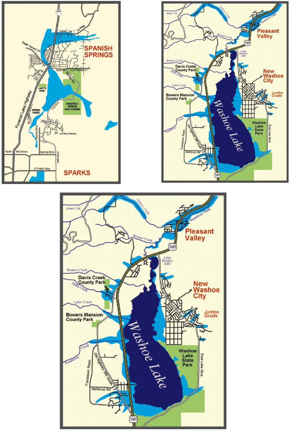
10 Note: These maps are based on information available from Washoe County and from Current (1994) Flood Zone Maps. However, because of the scale, they represent only approximate flood zone locations. For detailed information about your neighborhood, please study the firm maps themselves, which are located at the agencies listed below.

11
12 What to do During a Flood 1. Keep a battery-powered radio: It's for emergency use in case your electric power is cut off. 2. When outside the house, remember, floods are deceptive: Avoid flooded roads and don't attempt to walk or drive through floodwaters. 3. If, and only if time permits, take these precautionary steps: Turn off all utilities at the main power switch and close the main gas valve if evacuation is likely. Don't touch any electrical equipment unless it's in a dry area and you're standing on a piece of dry wood wearing rubber gloves and rubber-soled boots or shoes. Move valuable papers, furs, jewelry, clothing and other contents to upper floors or higher elevations. Fill bathtubs, sinks and jugs with clean water in case the regular supply is contaminated. Sanitize these items by rinsing with bleach. Board up windows or protect them with storm shutters. Bring outdoor possessions inside the house or tie them down securely. This includes lawn furniture, garbage cans, tools, signs and other movable objects that could be swept away or hurled about. 4. If it's safe to evacuate by car, consider the following: Stock the car with nonperishable foods (canned goods), a plastic container of water, blankets, firstaid kit, flashlights, dry clothing, and any special medication needed by your family. See family disaster supplies kit. Keep the gas tank at least half full since gas pumps at service stations will not be working if electricity is cut off. Don't drive where roads are flooded. Parts of the road may already be washed out. If your car stalls in a flooded area, quickly abandon it. Floodwaters can rise rapidly and sweep a car (and its occupants) away. Many deaths have resulted from attempts to move stalled vehicles, 5. If you're caught in your home by rising water, move to the second floor and, if necessary, to the roof: Take warm clothing, a flashlight and a portable radio. Wait for help - don't try to swim to safety. Rescue teams will be looking for you. What to do After a Flood 1. Prior to entering a building: Check for structural damage. Make sure it's not in danger of collapsing. Turn off any outside gas or electricity lines at the meter or tank. If you smell gas, call the utility company immediately. 2. Upon entering the building: Use a battery-operated flashlight, not an open flame, as a source of light. Gas may still be trapped inside. 3. Watch for downed electrical wires: Make certain the main power switch is turned off. Do not turn on any lights or appliances until an electrician has checked for short circuits. 4. Cover broken windows: Cover holes in the roof or walls to prevent further weather damage. 5. Proceed with immediate clean-up measures: Perishable food items pose a health risk. Throw out any fresh food and medicines that have come in contact with floodwaters.

13 For the insurance claim, the items should be listed and photographed before discarding. 6. Be careful of water for drinking and food preparation: Tap water should be used only if the public water system has been declared safe. In an emergency, water can be obtained by draining a hot water tank or melting ice cubes. 7. Take pictures of the damage to your building and its contents: Refrigerators, sofas and other appliances should be hosed off and kept for the adjuster's inspection. Use a household cleanser to clean items that will be kept. Any partially damaged items should be dried and aired. The adjuster will make recommendations as to repair or disposal. 8. All wet items must be thoroughly cleaned and dried: All equipment must be repaired and cleaned before use. 9. Be aware that roads, walkways and staircases may be undermined by floodwaters: They should be checked before use to make sure they're safe. Take pictures, etc. NOAA WEATHER RADIO - BUY ONE NOW! Up-to-the-Minute Flood Reports and Much More NOAA Weather Radio is not just for emergencies. It's a round-the-clock source of weather reports and information that helps you in preparing for the day ahead. When trouble arises, there is no substitute for NOAA Weather Radio. The constantly updated broadcasts provide dependable information when you need it mast. The network offers listeners vital information about where to turn for help after severe stows and other emergencies occur. The radios come in many sizes with variety of functions. Pocket radios can be used for outdoor activities, or carried on family trips. Many of the radios receive a tone-alert signal, triggering a built-in alarm that warns listeners of severe weather announcements in their area. Weather information available on NOAA Weather Radio in western Nevada and eastern California originates from the National Weather Advice office in Reno. The broadcast cycle repeats every 4 to 6 minutes, depending on weather conditions. Information on NOAA Weather Radio includes: 1. Flood watches or warnings affecting the Truckee, Carson, Walker, Susan or lower Humboldt Rivers. 2. Hazardous weather watches, warnings or advisories affecting the area. 3. Other emergency information as requested by local law enforcement, fire or emergency management agencies. 4. Short-term forecast of expected weather conditions over the next 1 to 6 hours. 5. Latest regional forecasts for the next five days. 6. Latest regional weather observations (updated hourly).

14 During the New Year s flood of 1997, downtown Reno and the Sparks industrial area were devastated by severe flooding. Such floods will undoubtedly continue to occur. How People's Activities Can Make Floods More Destructive In the lower reaches of a watershed, (a river basin), rivers meander through bottom lands that are flat and moist. When floods occur, natural rivers overflow their banks and occupy the bottom lands, also known as the river's floodplain. As the water spreads out, it loses velocity and erosive force and does relatively little damage to the environment or an occasional road or structure. However, if we "claim" the floodplain by building levees or floodwalls or straightening and channeling the river, we concentrate tremendous energy and destructive force in the channel. By forcing a channel to convey large volumes of water that normally spread out over a wide area, we make the current flow deeper and faster. The river either breaks through its levees or, if it stays within the artificial channel long enough, it can severely flood the community downstream. In addition, when people compact soil and construct impervious surfaces such as roads, parking lots and rooftops, the rainwater that would have soaked into the soil runs off the land rapidly into the nearest creek. When we urbanize land, we construct storm water collection systems that speed up the flow of runoff into rivers and streams. When we increase storm flows, or "peak flows," we also increase the likelihood of flooding downstream. Over the last 130 years, we have made many changes in the natural function of the Truckee River. We channelized the river in places and lowered its channel level by dynamiting the Vista Reef in the early 1960s. We built commercial, industrial and residential structures in many parts of the natural flood-plain. By building reservoirs such as Prosser Boca, Stampede and Martis Creek in the Sierra Nevada, we lessened the impact of winter floods on the Truckee Meadows. However, during the New Year's flood of 1997-in spite of the dams that were constructed upstreamdowntown Reno and the Sparks industrial area were devastated by severe flooding. Such floods will undoubtedly continue to occur. Some atmospheric scientists predict that if the earth's climate continues to warm, the Sierra Nevada win receive more of its winter precipitation in rainstorms. This may increase the probability and frequency of major flood events on the Truckee River. Because flood hazards will not go away and may indeed increase, we must consider ways to prepare for future flooding. These strategies include watershed management and floodplain management, using both structural and nonstructural flood-control methods.

15 We Need Coordinated Management Throughout the Watershed In many parts of the country, residents and government agencies are cooperating in efforts to improve land management throughout entire watersheds. Protecting the land, the vegetation and small steams could benefit It flood hazards in the Truckee River water-shed. During the l990s, most work in the watershed has focused on improving water quality in the ever. Since Reno and Sparks already have a state-of-theart wastewater treatment plant, recent efforts have emphasized the use of best management practices (BMPs) to reduce polluted runoff and BMPs are methods we can use to restore natural watershed Best Management Practices (BMPs) can help reduce flooding in watersheds: Erosion control Vegetation of stream banks Protection of natural wetlands Restoration of disturbed wetlands Runoff infiltration systems Construction practices to preserve and restore soil and vegetation Flood diversion or bypass structures Flood: retention basins which allow flood water to recharge into the ground functions. Used on both private and public lands, they can increase the watershed's ability to soak up water like a sponge, thereby reducing peak flows in rivers and streams. (See box at left). The Washoe-Storey Conservation District recently developed a restoration plan for Steamboat Creek. This plan urges implementation of erosion control BMPs and restoration of wetlands and riparian (stream-side) vegetation wherever possible. Similar efforts, if earned out in all parts of the Truckee River watershed, would not only improve water quality but also reduce flood flows from future storms. Government agencies can work to reduce the impact of roads. We can do a Better job of Managing our Floodplains Floodplain management refers to any program or action that reduces flood losses through the wise use of floodplains. Local governments have the primary responsibility for establishing floodplain management programs. They have the authority to guide land use and development within their jurisdictions, and are usually familiar with flooding problems and what might be done to solve them. State and federal governments can play a significant role in helping communities develop and implement floodplain management programs by providing the financial and technical assistance local governments might not otherwise have. In Nevada, call the Nevada Division of Water Planning, 1550 East College Parkway, Suite 142, Carson City, NV 89706, (775) , or your local government public works office. Citizens also have a responsibility to do their part to make floodplain management programs effective. Here's how: 1. The first rule is simple: stay out of floodplain! If you don't have to rebuild there, don't. You will only be putting the property and its future residents in danger.
 to reduce polluted runoff and BMPs are")
16 2. The second rule of floodplain management is to learn about the flood hazards in your area. If you're located in the flood-plain, learn what you can do to protect your property from losses. Once a flood zone has been identified, there are two ways to reduce losses within the floodplain-structural measures and nonstructural measures. (See box below). We Need Both Structural and Nonstructural Methods of Flood Control In the Truckee River watershed, property owners have been protected by costly flood-control dams, levees and channel improvements. After the record floods of 1950 and 1955, four reservoirs were built upstream. Flood experts credited these structures with preventing a worse flood in the Truckee Meadows in In the '90s however, there's a growing body of evidence that structural methods of flood control must be complemented by non-structural methods to achieve reduced flood hazards and improved water quality and habitat goals. (See box below.) The new science of floodplain management encourages The Two Main Types of Flood-Control Measures Structural Flood control dams and reservoirs Levees and dikes Channel improvements Lined floodway channels Nonstructural Comprehensive floodplain management Land-use planning and zoning Keeping agriculture in floodplains Land acquisition in floodplain areas Forecasting, warning and emergency preparedness Flood Insurance Flood proofing of structures nonstructural solutions, such as zoning, to prevent construction and housing in flood-hazard areas. You can play a vital role by providing input to local and regional planning efforts. If you support the goals of agencies to improve watershed and floodplain management, your children will be rewarded with safer communities in the 21st Century. Getting streams and creeks to function as complex water ecosystems is a powerful tool that can reduce the velocity and volume of flows during storm events. Some flood experts in cities such as Denver have opted to give their rivers more room to roam. Flood-control districts throughout the country are acquiring land in critical floodplain areas, razing structures, and returning the land to parks and wildlife habitat areas. This "river corridor" approach can reduce flood hazards while simultaneously increasing the aesthetic appeal of the river as a magnet for tourists and residents. In rural areas, farmers are being encouraged to keep floodplain land in agricultural production by creating conservation easements. This may be the single most cost-effective way to reduce flood hazards in a watershed. The Army Corps of Engineers has been reevaluating flooding problems along the Truckee since The Corps is engaged in studies to improve flood control and recreation, and restore and improve the natural resources along the river. The Washoe County Regional Water Planning Commission is working on a flood You can play a vital role by providing input to local and regional planning efforts. If you support the goals of agencies to improve watershed and floodplain management, our children will be rewarded with safer communities in the 21 st Century. -management plan as part of their Regional Water Plan. Call Washoe County Department of Water Resources for more details, (775) Act Now to Prepare for Floods "Flood Facts" has given you a number of ways you can prepare for flooding. You can educate yourself and your family. You can set up a plan to protect your home and prepare yourself for a flood. You can get involved in focal or regional efforts to lessen the damage of future floods. Public participation in government planning efforts is the best way to work toward long-term solutions of flood problems. Whatever measures you decide to take, act now! Use this guide so you'll be ready the next time a flood hits the Truckee Meadows.

TOWN OF HARRISBURG FIRE DEPARTMENT 6450 Morehead Road, Harrisburg North Carolina 28075 Phone: 704 455 3574 Fax 704 455 6391 www.harrisburgfd.
 FLOOD FACTS AND SAFETY TIPS Floods are one of the most common hazards in the United States. Flood effects can be local, impacting a neighborhood or community, or very large, affecting entire river basins
National Flood Safety Awareness Week is March 16-20, 2015
 Armond Budish Cuyahoga County Executive FOR IMMEDIATE RELEASE Media Contacts: Christopher Harris: (216) 443 7157 or cbharris@cuyahogacounty.us Rich Luchette: (216) 698 5637, (216) 797 0931, or rluchette@cuyahogacounty.us
Pennsylvania Flood Safety Awareness Week March 6-10th, 2015
 Pennsylvania Flood Safety Awareness Week March 6-10th, 2015 David J. Nicosia Warning Coordination Meteorologist National Weather Service Binghamton, NY Flooding is a coast to coast threat to the United
Flood Protection Tips
 Flood Protection Tips Information About Floodplains and Flood Prevention What is a floodplain? Floodplains serve many useful purposes, and those that are preserved in their natural or nearly natural state
Flood After Fire Fact Sheet
 FACT SHEET Flood After Fire Fact Sheet Risks and Protection Floods are the most common and costly natural hazard in the nation. Whether caused by heavy rain, thunderstorms, or the tropical storms, the
Preparing for A Flood
 Preparing for A Flood 1. Know if you are in a flood prone area. 2. Each year, update flood procedures to be followed by your company, employees and tenants: Including Emergency Contacts Evacuation Plans
BEFORE A FLOOD Prepare a family disaster plan and a disaster
 The City of Fort Lauderdale participates in the National Flood Insurance Program (NFIP) so that residents can obtain flood insurance to cover their property against loss from flood damage. Participation
FACT SHEET: HAZARDOUS MATERIALS ACCIDENTS
 FACT SHEET: HAZARDOUS MATERIALS ACCIDENTS A hazardous materials accident can occur anywhere. Communities located near chemical manufacturing plants are particularly at risk. However, hazardous materials
A. Flood Management in Nevada
 Nevada Division of Water Planning A. Flood Management in Nevada Introduction Flooding has been a concern for Nevada communities since the first settlers moved to the territory in the mid-1800 s. Fourteen
Emergency Management is responsible for coordinating the City of Houston s preparation for and response to emergency situations.
 CITY OF HOUSTON Office of Emergency Management October 2004 Emergency Management is responsible for coordinating the City of Houston s preparation for and response to emergency situations. Houston is exposed
Flood Emergency Response Planning: How to Protect Your Business from a Natural Disaster RIC005
 Flood Emergency Response Planning: How to Protect Your Business from a Natural Disaster RIC005 Speakers: Tom Chan, CEO, Global Risk Miyamoto Greg Bates, Principal, Global Risk Consultants Learning Objectives
Flood Risk Management
 Flood Risk Management Value of Flood Risk Management Every year floods sweep through communities across the United States taking lives, destroying property, shutting down businesses, harming the environment
Flood Risk Management
 Flood Risk Management Value of Flood Risk Management Value to Individuals and Communities Every year floods sweep through communities across the United States taking lives, destroying property, shutting
Insurance Questions: Clothes washers and dryers, food freezers and the food in them are covered if there is contents coverage.
 Introduction: Floods occur when runoff from rain or snowmelt exceeds the capacity of rivers, stream channels or lakes and overflows onto adjacent land. Floods can also be caused by storm surges and waves
GET READY IN 5 EASY STEPS HURRICANE SEASON
 HURRICANE SEASON GET READY IN 5 EASY STEPS It s true, major hurricanes don t hit the U.S. every year. But if you live on or near the coast, someday you may have to face a Category 3, or worse. Could be
Floodplain Information
 Floodplain Information A large percentage of the Ellis community is located in the floodplain of Big Creek. The term floodplain means the low-lying areas on both sides of Big Creek that will be covered
Thurston County Sandbag Priorities
 Thurston County Sandbag Priorities Sandbags are a critical resource during flood situations. They are used to limit water damage to buildings and to protect areas from inundation; however, the number of
Floods Module 2. - Mitigation Definition- Mitigation includes activities that: Prevent Reduce Lessen NORTHERN ILLINOIS UNIVERSITY COPYRIGHT 2007
 - Mitigation Definition- Mitigation includes activities that: Prevent Reduce Lessen 1 - Community Mitigation - Manage developments within a flood plain Construct barriers Levees Berms Dikes - Community
Floods are too much water on normally dry land. Rivers can flood after heavy rain has fallen over a long period of time. River flooding can last
 Floods are too much water on normally dry land. Rivers can flood after heavy rain has fallen over a long period of time. River flooding can last weeks or longer. River floods usually occur slowly enough
LOS ANGELES COUNTY S FLOODING HISTORY:
 LOS ANGELES COUNTY S FLOODING HISTORY: Since 1975, Los Angeles County has experienced twelve federally, declared flood disasters, with three of those disasters coming under El Niño conditions (1983, 1998,
5.0 OVERVIEW OF FLOOD DAMAGE REDUCTION MEASURES
 5.0 OVERVIEW OF FLOOD DAMAGE REDUCTION MEASURES Flood damage reduction consists of two basic techniques structural and non-structural. Structural methods modify the flood and take the flood away from people
With a combination of soaking rain, flying debris, high winds, and tidal surges, Hurricanes and tropical storms can pack a powerful punch.
 With a combination of soaking rain, flying debris, high winds, and tidal surges, Hurricanes and tropical storms can pack a powerful punch. Besides causing extensive damage in coastal areas, hurricanes
Flooding Hazards, Prediction & Human Intervention
 Page 1 of 10 EENS 3050 Tulane University Natural Disasters Prof. Stephen A. Nelson Flooding Hazards, Prediction & Human Intervention This page last updated on 19-Oct-2015 Hazards Associated with Flooding
BASEMENT FLOODING. Prevention Guide for. Homeowners
 BASEMENT FLOODING Prevention Guide for Homeowners 1 Did You Know? Floods are the most common hazards in Canada. Water damage is a common cause of loss for homeowner insurance. A heavy rainfall can result
Home Repair After a Hurricane Disaster
 FACILITATOR GUIDE ACTIVITY: COMING HOME AFTER A DISASTER Purpose: The purpose of this activity is to educate individuals and families about what to consider after their home has been damaged after a disaster
Landslides & Mudflows
 1 2 - What is a Landslide? - Geologic hazard Common to almost all 50 states Annual global Billions in losses Thousands of deaths and injuries 3 1 - What is a Landslide? - Gravity is driving force Some
flash floods and floods...
 NATIONAL OCEANIC AND ATMOSPHERIC ADMINISTRATION flash floods and floods... the Awesome Power! AVOID BEING CAUGHT IN A SITUATION LIKE THIS! A PREPAREDNESS GUIDE U.S. DEPARTMENT OF COMMERCE National Oceanic
EMERGENCY PREPAREDNESS
 EMERGENCY PREPAREDNESS REQUIREMENTS: Wind makes kites fly, fire can keep us warm, and rain helps the flowers and plants to grow. But sometimes the wind can blow too hard, fires can get too big or it can
City of Green Bay Department of Public Works Engineering Department
 City of Green Bay Department of Public Works Engineering Department The Difference Between Sanitary & Storm Sewers Contact Information: Department of Public Works City Hall 100 North Jefferson Street,
FLOOD PROTECTION BENEFITS
 IV. (340 points) Flood Protection Benefits A. Existing and potential urban development in the floodplain (50) 1. Describe the existing and potential urban development at the site and the nature of the
CITY OF BELLEAIR BEACH, FLORIDA
 CITY OF BELLEAIR BEACH, FLORIDA FLOOD INSURANCE INFORMATION Important Information for City of Belleair Beach Residents and Property Owners Regarding Flood, Risk, Insurance, Preparation, Evacuation, Safety
Family Emergency Preparedness Plan
 Family plan should address the following: Evacuation routes Family communications Utility shut-off and safety Insurance and vital records Evacuation plan Caring for animals Evacuation routes Draw a floor
The Basics of Indian Rocks Beach and Flood Hazard Information
 Helpful Flood Hazard Information Are you doing all you can to protect your property from flood damage? You have received this letter because your property is in an area that is subject to flooding. The
1. Review your insurance policies and coverage with your local agent.
 Dear Orange Beach Resident: The Community Development Office of The City of Orange Beach, Alabama is providing this information to the residents as part of a public outreach strategy as developed by the
Factors to Consider When Developing an Evacuation Plan
 The following should be viewed only as suggestions: Factors to Consider When Developing an Evacuation Plan 1. You must identify your document with a specific title and explanation. Example: Evacuation
Flooding in Brisbane
 Flooding in Brisbane A guide for residents photo provided by Conan Whitehouse Brisbane is a thriving, world-class city, enjoyed by residents and visitors. Like many cities around the world, Brisbane has
PREPARING FOR A FLOOD
 Floods are typically caused by seasonal melting snow, ice jams, heavy spring rains and summer thunderstorms. Flash flooding is often caused by violent rain storms or breaking dams, and usually occurs with
Flood Insurance Claims Handbook
 National Flood Insurance Program Flood Insurance Claims Handbook FEMA F-687 (07-05) Thank you for protecting yourself through the National Flood Insurance Program Table of Contents Purchasing flood insurance
Standard Operating Procedures for Flood Preparation and Response
 Standard Operating Procedures for Flood Preparation and Response General Discussion Hurricanes, tropical storms and intense thunderstorms support a conclusion that more severe flooding conditions than
Draft Dapto Flood Management Plan
 NATURE OF HAZARD Draft Dapto Flood Management Plan Since Dapto school has been established on the current site there have been two floods. The SES is responsible for responding to floods in NSW. During
ARE YOU PREPARED FOR A FLOOD IN YOUR NEIGHBORHOOD?
 ARE YOU PREPARED FOR A FLOOD IN YOUR NEIGHBORHOOD? YOU ARE RECEIVING THIS BROCHURE BECAUSE YOUR PROPERTY IS LOCATED WITHIN OR NEAR A SPECIAL FLOOD HAZARD AREA WITHIN UNINCORPORATED VENTURA COUNTY History
Agent Guide to Flood Insurance. Have a flair for selling flood? This guide will make it even easier
 Agent Guide to Flood Insurance Have a flair for selling flood? This guide will make it even easier Growth! That s what selling flood insurance can mean for your business. But selling and servicing flood
Town of Amherst Flood Plan Annex
 Town of Amherst Flood Plan Annex The following document is an annex to the Town of Amherst Disaster Plan and is specifically used as a guideline for Flooding events Flood Plans can enable a flexible response
Flash Flood Science. Chapter 2. What Is in This Chapter? Flash Flood Processes
 Chapter 2 Flash Flood Science A flash flood is generally defined as a rapid onset flood of short duration with a relatively high peak discharge (World Meteorological Organization). The American Meteorological
RESTORING streams to reduce flood loss
 RESTORING streams to reduce flood loss Flood Loss Reduction the Natural Way Flood disasters have become a regular Floods can devastate local occurrence. One in your community may have communities. threatened
Flood Protection Information Flood Basics
 Flood Protection Information Flooding is an act of nature which respects no boundary lines, either community or personal. Floodwater can cover many blocks with water depths up to four or five feet and
Cabarrus County Floodplain Information TABLE OF CONTENTS
 Cabarrus County Floodplain Information TABLE OF CONTENTS Flood Hazard What is 100-year flood? Does Cabarrus County flood? Flood Safety How do I protect my property from flood damage? Is there anything
Preparation. Preparation. Step 2 Prepare an emergency kit. Step 1 Prepare your emergency plan. Step 4 Tune into warnings
 This emergency toolkit provides you with steps to take before and during emergencies to protect you and your property. The Victoria State Emergency Service (SES) is a volunteer organisation dedicated to
Landslides. Landslides-1. March 2007
 Landslides Learn if landslides, including debris flows, could occur in your area by contacting local officials, your state geological survey or department of natural resources, or the geology department
GEOTECHNICAL ISSUES OF LANDSLIDES CHARACTERISTICS MECHANISMS PREPARDNESS: BEFORE, DURING AND AFTER A LANDSLIDE QUESTIONS FOR DISCUSSIONS
 GEOTECHNICAL ISSUES OF LANDSLIDES CHARACTERISTICS MECHANISMS PREPARDNESS: BEFORE, DURING AND AFTER A LANDSLIDE QUESTIONS FOR DISCUSSIONS Huge landslide Leyte, Phillipines, 1998 2000 casulties Small debris
SECTION 1.0 STATUTORY AUTHORIZATION AND PURPOSE
 A local law for Flood Damage Prevention as authorized by the New York State Constitution, Article IX, Section 2, and Environmental Conservation Law, Article 36 1.1 FINDINGS SECTION 1.0 STATUTORY AUTHORIZATION
CITY OF HUMBLE OFFICE OF EMERGENCY MANAGEMENT. 110 W. Main St. Humble, Tx. 77338 ph. 281 446 4928 Email; cjohnson@cityofhmble.net
 CITY OF HUMBLE OFFICE OF EMERGENCY MANAGEMENT 110 W. Main St. Humble, Tx. 77338 ph. 281 446 4928 Email; cjohnson@cityofhmble.net Emergency Management Director: Mayor Donnie McMannes Emergency Management
Preparing Your Business for a Flood
 CHECKLISTS Before a Flood Stay in touch with what s happening and listen for warnings and advisories through the media or through local community messaging. A flood watch means flooding is possible. A
Outlet stabilization structure
 Overview of Sedimentation and Erosion Control Practices Practice no. 6.41 Outlet stabilization structure Erosion at the outlet of channels, culverts, and other structures is common, and can cause structural
2015 CRS Community Outreach. City of Folly Beach, South Carolina Flood Plain Management Offices PO Box 48 Folly Beach, SC 29439 843-588-2447 ext 1838
 City of Folly Beach, South Carolina Flood Plain Management Offices PO Box 48 Folly Beach, SC 29439 843-588-2447 ext 1838 The dark line around this map delineates the extent of the Special Flood Hazard
Flood Checklist ACTION TO BE TAKEN BEFORE THE FLOOD SEASON
 Flood Checklist The following may serve as a checklist when preparing for a flood. This checklist should be tailored to processes/operations, flood protection equipment and flood potentials at your specific
Flood Action Plan Disaster Preparedness from Liberty Mutual Insurance
 Flood Action Plan Disaster Preparedness from Liberty Mutual Insurance Floods can be devastating, causing those affected to lose their home, their property, their pets, and even their lives. Floods and
Frequently-Asked Questions about Floodplains and Flood Insurance FLOOD INSURANCE
 Frequently-Asked Questions about Floodplains and Flood Insurance What is a floodplain? The floodplain is any area covered by water during normal water flows, and which could be inundated as a result of
EMERGENCY RESPONSE PROCEDURES
 EMERGENCY RESPONSE PROCEDURES Emergency Telephone Numbers Life Threatening Emergency................................. 911 Local Police............................. Local Fire and Paramedics.................
ECONOMIC ANALYSIS FLOOD DAMAGE REDUCTION. Lower Carmel River Floodplain Restoration and Enhancement Project
 ECONOMIC ANALYSIS FLOOD DAMAGE REDUCTION Lower Carmel River Floodplain Restoration and Enhancement Project I. Description of the Project and its Relationship to Other Projects in the Proposal The Lower
California Floods: Be Aware, Be Prepared
 Flooding in California Do you live in California?Do you visit California? Do you know when it typically floods in California? Do you know that every county in California has been declared a federal flood
California Alluvial Fan Task Force
 California Alluvial Fan Task Force County of San Diego Alluvial Fan Flooding and Risk Reduction Sara Agahi, PE, CFM January 4, 2008 Outline of Presentation Show location of San Diego County Alluvial Fan
Landslides & Mudslides
 Landslides & Mudslides Landslides, also known as mudslides and debris flow, occur in all U.S. states and territories. In snowy mountainous areas winter snow landslides are called avalanches. Landslides
Shooks Run Drainage Study Basic Terminology
 Shooks Run Drainage Study Basic Terminology PREPARED FOR: PREPARED BY: City of Colorado Springs CH2M DATE: April 9, 2015 Introduction This document is intended to provide an introduction to Colorado Springs
The Hydrologic Cycle. precipitation evaporation condensation transpiration infiltration surface runoff transport groundwater water table.
 The Hydrologic Cycle Page 1 of 1 Name Directions: The hydrologic cycle consists of the processes that change and move water through the earth s system. Use the terms below to label the hydrologic cycle.
SHELTER-IN-PLACE OR EVACUATE
 SHELTER-IN-PLACE OR EVACUATE WOULD YOU KNOW WHAT TO DO? A PREPAREDNESS GUIDE FOR THE HOME No matter where you live, your community may experience a natural or man-made disaster a tornado, floor, winter
Small Dam Hazard Assessment Inventory
 Small Dam Hazard Assessment Inventory What would happen if your dam were to fail? This is a question that most dam owners hope they will never have to answer. However it is a question you, as a responsible
The Boscastle Flood 2004
 The Boscastle Flood 2004 by Phil Bull Causes of the Flood Physical Causes The flood took Boscastle entirely by surprise - it was a flash flood event & the village is not prone to regular annual flooding
What does it mean to live Behind a Levee?
 What does it mean to live Behind a Levee? Ask Yourself This: Are My Home and Loved Ones Safe from Floods? Most people know that levees are structures built near rivers and lakes to reduce the risk of flooding.
would your business stay afloat? A guide to preparing your business for flooding
 would your business stay afloat? A guide to preparing your business for flooding Flooding is the most common and widespread natural disaster in the UK. Since 1998 there has been at least one serious flood
2012 Flood Hazard Prevention By Building and Planning Operations Manager Lou Ann Patellaro
 2012 Flood Hazard Prevention By Building and Planning Operations Manager Lou Ann Patellaro In 1968, Congress created the National Flood Insurance Program (NFIP) to provide affordable flood insurance to
Lower Raritan Watershed Management Area Stormwater & Flooding Subcommittee Strategy Worksheet LRSW-S3C1
 Strategy Name: Reduce Existing Potential for Flood Damages LRSW-S3C1. Develop and implement a program to: Minimize flood damages through the use of structural measures. Minimize flood damages through the
Guidelines for. Permeable Pavement
 What is permeable pavement? Guidelines for Permeable Pavement When rainwater falls on conventional pavement, such as concrete, it accumulates and then flows across and off of this impervious surface as
Flood Insurance Secrets That Most Agents Won t Tell You and Most People Don t Find Out Until It s Too Late!
 Flood Insurance Secrets That Most Agents Won t Tell You and Most People Don t Find Out Until It s Too Late! By Scott Kirby, Licensed Insurance Agent and Consumer Advocate In this report, you will discover
CITY OF HIGHLAND PARK, ILLINOIS Stormwater Management Fact Sheet
 CITY OF HIGHLAND PARK, ILLINOIS Stormwater Management Fact Sheet WHAT IS STORMWATER MANAGEMENT? Stormwater management is the method for channeling rainfall through pipes and sewers away from property to
Flooding Fast Facts. flooding), seismic events (tsunami) or large landslides (sometime also called tsunami).
, seismic events (tsunami) or large landslides (sometime also called tsunami).") Flooding Fast Facts What is a flood? Flooding is the unusual presence of water on land to a depth which affects normal activities. Flooding can arise from: Overflowing rivers (river flooding), Heavy rainfall
Flooding Fast Facts What is a flood? Flooding is the unusual presence of water on land to a depth which affects normal activities. Flooding can arise from: Overflowing rivers (river flooding), Heavy rainfall
CITY OF WOODSTOCK NATIONAL FLOOD INSURANCE PROGRAM INFORMATION
 CITY OF WOODSTOCK NATIONAL FLOOD INSURANCE PROGRAM INFORMATION The City of Woodstock participates in the National Flood Insurance Program (NFIP). The NFIP makes federally backed flood insurance available
Important safety tips for Electric and Gas Safety. Source: PSEG Hurricane Irene Web site on InfoCentral
 Hurricane Readiness Important safety tips for Electric and Gas Safety Source: PSEG Hurricane Irene Web site on InfoCentral For updates on PSE&G outage information, please visit: www.twitter.com\psegoutageinfo
Post-Flood Assessment
 Page 1 of 7 Post-Flood Assessment CHAPTER 4 AGENCY COORDINATION Agency coordination is an essential element for the operation of the flood management systems in the Central Valley. Due to the nature of
www.focusonfloods.org
 Floods Happen. Lessen the Loss. Loss of life and property to flooding is the most common, yet preventable, natural disaster in the United States. The following worksheets were developed to increase the
Floodplains are lands that are subject to periodic flooding from water. Floodplains in their natural state:
 A GUIDE TO FLOOD HAZARDS Prepared by the Harford County Department of Planning and Zoning This document is available in alternative format upon request. NATURAL BENEFITS OF FLOODPLAINS Floodplains are
Division of Water Frequently asked floodplain questions
 Division of Water Frequently asked floodplain questions Q: Where can I find copies of the floodplain mapping? A: Local floodplain administrators will have copies of the FEMA mapping. (Generally the local
Flooding advice & guidance
 Flooding advice & guidance Conwy County Borough Council Environment Department www.conwy.gov.uk Useful contacts Conwy County Borough Council 24 hour flood response: 01492 577999 www.conwy.gov.uk/flooding
City of Paso Robles Community Development Department Construction Site Storm Water Quality Requirements
 City of Paso Robles Community Development Department Construction Site Storm Water Quality Requirements Overview of the City s Construction Storm Water Program The City of Paso Robles is committed to protecting
The. year. floods are
 Introduction The Ascension Parish Council is dedicated to minimizing thee loss of life and property that is associated with flooding events. Education and prevention are valuable and proven tools that
Preparing Your Business for a Flood
 This document was generated in part from the excellent work done by EPICC (Emergency Preparedness for Industry and Commerce Council). Please refer to EPICC s website http://www.epicc.org/ to learn more
DOÑA ANA COUNTY DESIGN STORM CRITERIA GUIDELINES FOR COMMERCIAL AND RESIDENTIAL SITES. Run-off Analysis Methods
 DOÑA ANA COUNTY DESIGN STORM CRITERIA GUIDELINES FOR COMMERCIAL AND RESIDENTIAL SITES Run-off Analysis Methods This document sets forth the minimum design, technical criteria and specifications for the
There to help when you need us most.
 There to help when you need us most. Preparing your home and family for the unthinkable. Disaster can strike anywhere, anytime with little or no warning. Are you really prepared? Disaster can strike quickly
INFORMATION BULLETIN BUSINESS FLOOD PLANNING AND MITIGATION GUIDE ACE GLOBAL RISK ENGINEERING. Flood risk assessment. Introduction
 ACE GLOBAL RISK ENGINEERING INFORMATION BULLETIN BUSINESS FLOOD PLANNING AND MITIGATION GUIDE Introduction The most common cause of flooding is due to established water storage areas (natural and man-made)
Detention Ponds. Detention Ponds. Detention Ponds. Detention Ponds. Detention Ponds. Detention Ponds. CIVL 1112 Detention Ponds - Part 1 1/12
 CIVL 1112 - Part 1 1/12 The water cycle, also known as the hydrologic cycle, describes the continuous movement of water on, above and below the surface of the Earth. The water cycle, also known as the
Burnt River Black River and Gull River Flood Contingency Plan
 Burnt River Black River and Gull River Flood Contingency Plan Objective: The objective of this plan is to preplan and prepare for flooding events in the Burnt River, Black River and Gull River area of
SOME COMMON QUESTIONS ABOUT FLOODPROOFING
 SOME COMMON QUESTIONS ABOUT FLOODPROOFING WHEN DOES FLOODING OCCUR? Although flooding can occur at any time of the year, the risks of high floods are greatest in the spring and summer. Spring floods are
How To Amend A Stormwater Ordinance
 Regulatory Alternatives to Address Stormwater Management and Flooding in the Marlboro Street Study Area Alternative 1: Amend Existing Local Regulations This proposed alternative provides an incremental
would your business stay afloat?
 would your business stay afloat? A guide to preparing your business for flooding Environment Agency A guide to preparing your business for flooding 0 Flooding is the most common and widespread natural
FLOOD PROTECTION AND ECOSYSTEM SERVICES IN THE CHEHALIS RIVER BASIN. May 2010. Prepared by. for the. 2010 by Earth Economics
 FLOOD PROTECTION AND ECOSYSTEM SERVICES IN THE CHEHALIS RIVER BASIN May 2010 Prepared by for the Execubve Summary The Chehalis Basin experienced catastrophic flooding in 2007 and 2009. In response, the
HURRICANE EVACUATION GUIDE
 booklet-final 6/30/00 9:41 AM Page 1 E M E R G E N C Y P R E P A R E D N E S S HURRICANE EVACUATION GUIDE Vital information you need to know in case of a hurricane evacuation. Information brought to you
Household Preparedness Guide
 PreparedBC: Household Preparedness Guide A guide for protecting your family PreparedBC HOUSEHOLD PREPAREDNESS GUIDE Earthquakes, tsunamis, floods and wildfires are just some of the potential hazards in
A Developer s Guide: Watershed-Wise Development
 A Developer s Guide: Watershed-Wise Development Environmental Protection What is a watershed? It does not matter how far away you build from a creek, lake, or the ocean, you are in a watershed. Another
Multi-Jurisdictional Hazard Mitigation Plan
 Flooding General Flooding is the leading cause of death among all types of natural disasters throughout the United States, with its ability to roll boulders the size of cars, tear out trees, and destroy
rescue and relief efforts in the aftermath of flooding, (iii) repair of flood damaged public facilities and utilities, and
 repair of flood damaged public facilities and utilities, and") 1. Purpose (1) It is the purpose of this Ordinance to protect human life, health, and property from flood conditions, to preserve the ability of floodplains to carry and discharge a base flood, and to
1. Purpose (1) It is the purpose of this Ordinance to protect human life, health, and property from flood conditions, to preserve the ability of floodplains to carry and discharge a base flood, and to