' Minutes " Seconds DDD MM' SS.S" 32 18' 23.1" N ' 52.5" W. How do we measure Latitude and Longitude? Degrees, Minutes and Seconds
|
|
|
- Angela Daniels
- 7 years ago
- Views:
Transcription
1 How do we measure Latitude and Longitude? Longitude: Just like a circle, any longitude line (or ring) on the earth is separated into 360º. It is easiest to visualize along the equator. Looking at the longitude map there are usually 24 sections (divided by the lines), 12 each for the west and east sides. Taking 360º and dividing by 24, we know that each section is 15º across. The reference point (0º) is the prime meridian, at Greenwich, England. From here you can measure 180º to the west, 0 to 180º. You can also measure 180º to the east, 0 to 180º. Western degrees are always negative, and eastern degrees are always positive. As an example, Newcastle, Australia is at º longitude. Hence it is east of the Greenwich Meridian. Latitude: Starting from the equator, you can measure 90º northward and 90º southward. As an example, Newcastle, Australia is at 32.55º S. The South Pole is at 90º S, and the North Pole is at 90º N. The distance covered by a single degree is too large for practical use, so the system of minutes and seconds was developed. A degree is divided into 60 minutes. For even more detailed use, a minute is divided into 60 seconds. One second of latitude corresponds to about 30meters on the surface of the earth. 1 degree = 60 minutes 1 minute = 60 seconds 1 degree = 3600 seconds (60 minutes x 60 seconds) Symbols forº, minutes and seconds: Degrees ' Minutes " Seconds The three common formats: DDD MM' SS.S" DDD MM.MMM' DDD.DDDDD Degrees, Minutes and Seconds Degrees and Decimal Minutes Decimal Degrees Degrees, Minutes and Seconds DDD MM' SS.S" 32 18' 23.1" N ' 52.5" W This is the most common format used to mark maps. It's also the most cumbersome to work with. It's a lot like telling time Page 9
2 There are sixty seconds in a minute (60" = 1') and There are sixty minutes in a degree (60' = 1 ). Keeping in mind a few easy conversions between seconds and decimal minutes will help when working with maps that useº, minutes and seconds. 15 seconds is one quarter of a minute or 0.25 minutes 30 seconds is one half of a minute or 0.5 minutes 45 seconds is three quarters of a minute or 0.75 minutes Degrees and Decimal Minutes DDD MM.MMM' ' N ' W This is the format most commonly used when working with electronic navigation equipment. Decimalº DDD.DDDDD N W or , This is the format used by most computer-based mapping systems. Often the N-S and E-W designators are omitted. Positive values of latitude are north of the equator, negative values to the south. Watch the sign on the longitude, most programs use negative values for west longitude, but a few are opposite. This saves a lazy western hemisphere programmer from having to type in a minus sign before most of their longitude values. Which format should you use? First off, if you are working with other people who have agreed upon a format to use, then you should probably use that format. In this course you will be required to work extensively with Global Positioning Systems (GPS), which have a default setting of degrees and decimal minutes, but you will be made aware of how to use all formats Page 10
3 Plotting and Measuring Latitude Lines of latitude are parallel and evenly spaced; therefore a degree of latitude represents a constant distance on the ground. This makes plotting latitude very straightforward. Place the ruler so that it spans the lines of latitude and the point to be measured or plotted falls between. Orient the ruler north to south. The zero minute end of the ruler should be on the northern line of latitude, when you're in the southern hemisphere (and vice versa for the northern). To measure the latitude of a point on the map, read the value from the ruler at the point, and add it to the latitude of the line at the zero end of the ruler. On the picture to the left, the ruler indicates the X is at the 4' mark, for a resulting latitude of 37 34' N. To plot the location of given coordinates, make a small mark on the map to indicate the line of latitude the coordinates fall on. Plotting and Measuring Longitude Longitude represents an east-west position on the earth. Longitude increases as you move away from the prime meridian, or 0, in Greenwich, England. Because the lines of longitude converge at the poles, a degree of longitude represents a varying distance on the ground, depending on the latitude. Place the ruler so that it spans the lines of longitude the point to be measured or plotted falls between. The ruler will need to be on a diagonal to fit. To measure the longitude of a point on the map, slide the ruler vertically, keeping the ends on the lines of longitude marked on the map, until the edge of the ruler touches the point to be measured. You may Figure 2.6 Measuring longitude (from Maptools.com) Figure 2.5 Measuring latitude (from Maptools.com) need to extend the lines of longitude above or below the map to properly position the ruler. On the picture to the left, the ruler indicates the X is at the 3.5' mark, for a resulting longitude of ' W. To plot a longitude coordinate, make a small tic on the map to indicate the line of longitude. The point of interest is located where the plotted lines of latitude and longitude cross. Page 11
4 Figure 2.7 Measuring longitude part 2 (from Maptools.com) Test Your Knowledge This exercise will test your ability to plot Latitude/Longitude coordinates onto a map and to determine the coordinates of features on the map. The page following contains a very simple 1:100,000 scale map, the instructions for the exercise, and a 1:100,000 scale Lat/Lon ruler. Cut the ruler out, and use it for the exercise. Page 12
5 Cut out the 1: scale ruler at the bottom of the page and use it with the map to complete the exercise. Determine the coordinates for the points labeled A, B, and C. Find the features on the map at the following coordinates: 37º 35 N 122º 05.8 W 37º N 122º W 37º 33.6 N 122º 03.7 W Page 13
6 Answers to the Lat/Lon Exercise Measuring coordinates for points on the map: A 37 35' N ' W B ' N ' W or 37 32' 30" N ' 30" W C ' N ' W or 37 36' 45" N ' 15" W Plotting coordinates onto the map: 37 35' N ' W is the camp site 37 31' 30" N ' 10" W is the mine If you don't have a map or ruler to make accurate estimations of latitude and longitude, you can still make good guestimates by interpolating and estimating between the lines. Just remember to allow for the convergence of lines of longitude as you get closer to the poles. Test Your Knowledge Use the map below to complete the table following. Page 14
7 Place Latitude Longitude Place Latitude Longitude Seymour 36º 58 S 145º 10 E Presenting Information on Maps - Symbols and Colors Symbols Map symbols are signs or colours drawn on the map to represent features on the earth s surface. Every symbol used on a map must be listed in a key or legend next to the map. Symbols must be simple yet easily identified in what they represent. Colour Maps also use colour as a type of symbol. Standard colours are used to represent water, buildings and land features. Details of these are listed below. Most topographic maps use the following symbols and colors to designate different features (see Figure 2.8) Black - man-made features such as roads, buildings, etc. Blue - water, lakes, rivers, streams, etc. Brown - contour lines Green - areas with substantial vegetation (could be forest, scrub, etc.) White - areas with little or no vegetation; white is also used to depict permanent snowfields and glaciers Red - major highways; boundaries of public land areas Purple - features added to the map since the original survey. These features are based on aerial photographs but have not been checked on land. Page 15
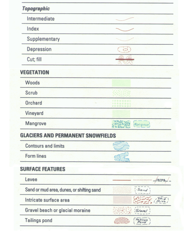
8 Page 16

9 Figure 2.8 Topographic map Symbols (from US Geological Survey) Page 17
.")
10 Map Legend The map legend contains a number of important details. The figures below display a typical topographic map legend. In addition, maps generally include latitude and longitude and the names of the adjacent maps (depicted on the top, bottom, left side, right side and the four corners of the map). The major features on the map legend are shown in Figure 2.9 and labeled below. 1. Map Name 2. Year of Production and Revision 3. General Location in State 4. Next Adjacent Quadrangle Map 5. Map Scale 6. Distance Scale 7. Contour Interval 8. Magnetic Declination 9. Latitude and Longitude Page 18
11 Figure 2.9 Topographic map legend features (from US Geological Survey) Page 19
How to Find Coordinates on Common Smartphones
 How to Find Coordinates on Common Smartphones 1 Table of Contents Contents Blackberry... 3 Blackberry Z10... 4 iphone... 6 Phones with an Android Operating System (HTC, Samsung, Sony)... 8 Appendix A...
Topographic Maps Practice Questions and Answers Revised October 2007
 Topographic Maps Practice Questions and Answers Revised October 2007 1. In the illustration shown below what navigational features are represented by A, B, and C? Note that A is a critical city in defining
Map reading made easy
 Map reading made easy What is a map? A map is simply a plan of the ground on paper. The plan is usually drawn as the land would be seen from directly above. A map will normally have the following features:
The Basics of Navigation
 The Basics of Navigation Knowledge of map reading and the use of the compass is an indispensable skill of bushcraft. Without this skill, a walker is a passenger and mere follower on a trip. To become a
Plotting Earthquake Epicenters an activity for seismic discovery
 Plotting Earthquake Epicenters an activity for seismic discovery Tammy K Bravo Anne M Ortiz Plotting Activity adapted from: Larry Braile and Sheryl Braile Department of Earth and Atmospheric Sciences Purdue
CONTENTS. Page 3 What is orienteering? Page 4 Activity: orienteering map bingo. Page 5 Activity: know your colours. Page 6 Choosing your compass
 THE RIGHT DIRECTION SCOUT ORIENTEER ACTIVITY BADGE CONTENTS Page What is orienteering? Page 4 Activity: orienteering map bingo Page 5 Activity: know your colours Page 6 Choosing your compass Page 7 Activity:
4 The Rhumb Line and the Great Circle in Navigation
 4 The Rhumb Line and the Great Circle in Navigation 4.1 Details on Great Circles In fig. GN 4.1 two Great Circle/Rhumb Line cases are shown, one in each hemisphere. In each case the shorter distance between
OBJECTIVES. Identify the means by which latitude and longitude were created and the science upon which they are based.
 Name: Key OBJECTIVES Correctly define: isolines, gradient, topographic map, contour interval, hachured lines, profile, latitude, longitude, hydrosphere, lithosphere, atmosphere, elevation, model EARTH
Coordinate Systems. Orbits and Rotation
 Coordinate Systems Orbits and Rotation Earth orbit. The earth s orbit around the sun is nearly circular but not quite. It s actually an ellipse whose average distance from the sun is one AU (150 million
SECOND GRADE 1 WEEK LESSON PLANS AND ACTIVITIES
 SECOND GRADE 1 WEEK LESSON PLANS AND ACTIVITIES UNIVERSE CYCLE OVERVIEW OF SECOND GRADE UNIVERSE WEEK 1. PRE: Discovering stars. LAB: Analyzing the geometric pattern of constellations. POST: Exploring
3D Drawing. Single Point Perspective with Diminishing Spaces
 3D Drawing Single Point Perspective with Diminishing Spaces The following document helps describe the basic process for generating a 3D representation of a simple 2D plan. For this exercise we will be
Grades 3-5. Benchmark A: Use map elements or coordinates to locate physical and human features of North America.
 Grades 3-5 Students use knowledge of geographic locations, patterns and processes to show the interrelationship between the physical environment and human activity, and to explain the interactions that
3D Drawing. Single Point Perspective with Diminishing Spaces
 3D Drawing Single Point Perspective with Diminishing Spaces The following document helps describe the basic process for generating a 3D representation of a simple 2D plan. For this exercise we will be
IAntarcticaI. IArctic Ocean I. Where in the World? Arctic Ocean. Pacific Ocean. Pacific Ocean. Atlantic Ocean. North America.
 Name ------------------------------ Where in the World? Continents and s Arctic Pacific Pacific Atlantic.1.... 0" o ". North America South America Antarctica Arctic 261 Name Where in the World Continents
Stellarium a valuable resource for teaching astronomy in the classroom and beyond
 Stellarium 1 Stellarium a valuable resource for teaching astronomy in the classroom and beyond Stephen Hughes Department of Physical and Chemical Sciences, Queensland University of Technology, Gardens
Which month has larger and smaller day time?
 ACTIVITY-1 Which month has larger and smaller day time? Problem: Which month has larger and smaller day time? Aim: Finding out which month has larger and smaller duration of day in the Year 2006. Format
An Introduction to Coordinate Systems in South Africa
 An Introduction to Coordinate Systems in South Africa Centuries ago people believed that the earth was flat and notwithstanding that if this had been true it would have produced serious problems for mariners
Experiment 5: Magnetic Fields of a Bar Magnet and of the Earth
 MASSACHUSETTS INSTITUTE OF TECHNOLOGY Department of Physics 8.02 Spring 2005 Experiment 5: Magnetic Fields of a Bar Magnet and of the Earth OBJECTIVES 1. To examine the magnetic field associated with a
The Globe Latitudes and Longitudes
 INDIAN SCHOOL MUSCAT MIDDLE SECTION DEPARTMENT OF SOCIAL SCIENCE The Globe Latitudes and Longitudes NAME: CLASS VI SEC: ROLL NO: DATE:.04.2015 I NAME THE FOLLOWING: 1. A small spherical model of the Earth:
World Map Lesson 4 - The Global Grid System - Grade 6+
 World Map Lesson 4 - The Global Grid System - Grade 6+ Activity Goal To use the global grid system of latitude and longitude to find specific locations on a world map. Materials Needed: A pencil, a ruler,
Lines on Maps and Globes. Cross Curricular Writing Activity Social Studies Grade 4
 Lines on Maps and Globes Cross Curricular Writing Activity Social Studies Grade 4 Fourth Grade Social Studies Standard Map: Chart/Globe The learner will be able to use maps, charts, graphs, and globes
Searching Land Records thru the BLM General Land Office Records.
 Searching Land Records thru the BLM General Land Office Records. Land Records can be an exciting addition to your family history search. The United States Government transferred ownership of land to millions
Map Navigation Controls. An Interactive, Locally Based Knowledge Resource LivingstonLive.org/maps OR gisapps/livingstonviewerinternal
 Livingston County s Internet Mapping Portal User Guide An Interactive, Locally Based Knowledge Resource LivingstonLive.org/maps OR gisapps/livingstonviewerinternal A vast majority of County government
Thematic Map Types. Information Visualization MOOC. Unit 3 Where : Geospatial Data. Overview and Terminology
 Thematic Map Types Classification according to content: Physio geographical maps: geological, geophysical, meteorological, soils, vegetation Socio economic maps: historical, political, population, economy,
Motion & The Global Positioning System (GPS)
") Grade Level: K - 8 Subject: Motion Prep Time: < 10 minutes Duration: 30 minutes Objective: To learn how to analyze GPS data in order to track an object and derive its velocity from positions and times.
Grade Level: K - 8 Subject: Motion Prep Time: < 10 minutes Duration: 30 minutes Objective: To learn how to analyze GPS data in order to track an object and derive its velocity from positions and times.
Lines of Latitude and Longitude
 ED 5661 Mathematics & Navigation Teacher Institute Keith Johnson Lesson Plan Lines of Latitude and Longitude Lesson Overview: This lesson plan will introduce students to latitude and longitude along with
Unit One Study Guide
 Unit One Study Guide Terms BCE: Before the Common Era. Referring to the time before Christ s birth. CE: Common Era. Referring to the time after Christ s birth. BC: Before Christ. Referring to the time
National Register of Historic Places: GIS Webinar Cultural Resource GIS Facility National Park Service June 2012
 National Register of Historic Places: GIS Webinar Cultural Resource GIS Facility National Park Service June 2012 In February and March 2012 the National Register of Historic Places held webinars in conjunction
Latitude, Longitude, and Time Zones
 Latitude, Longitude, and Time Zones Typical Graph This is an example of a typical graph. It is made up of points that are connected by a line. Y axis Typical Graph Each point has two values: (4,7) An X
Stage 4. Geography. Blackline Masters. By Karen Devine
 1 Devine Educational Consultancy Services Stage 4 Geography Blackline Masters By Karen Devine Updated January 2010 2 This book is intended for the exclusive use in NSW Secondary Schools. It is meant to
The Map Grid of Australia 1994 A Simplified Computational Manual
 The Map Grid of Australia 1994 A Simplified Computational Manual The Map Grid of Australia 1994 A Simplified Computational Manual 'What's the good of Mercator's North Poles and Equators, Tropics, Zones
Learning about GPS and GIS
 Learning about GPS and GIS Standards 4.4 Understand geographic information systems (G.I.S.). B12.1 Understand common surveying techniques used in agriculture (e.g., leveling, land measurement, building
Where On Earth Will Three Different Satellites Provide Simultaneous Coverage?
 Where On Earth Will Three Different Satellites Provide Simultaneous Coverage? In this exercise you will use STK/Coverage to model and analyze the quality and quantity of coverage provided by the Earth
HOW TO GET A SOIL MAP FROM THE WEB SOIL SURVEY
 Cooperative Extension of Ocean County Extension Center 1623 Whitesville Road Toms River, NJ 08755-1199 njaes.rutgers.edu/extension 732-349-1227 4-H 732-349-1246 Agriculture 732-349-1247 FCHS 732-349-1247
Pre and post-visit activities - Navigating by the stars
 Pre and post-visit activities - Navigating by the stars Vocabulary List Adult Education at Scienceworks Pre-visit Activity 1: What is longitude and latitude? Activity 2: Using the Southern Cross to find
Earth Coordinates & Grid Coordinate Systems
 Earth Coordinates & Grid Coordinate Systems How do we model the earth? Datums Datums mathematically describe the surface of the Earth. Accounts for mean sea level, topography, and gravity models. Projections
UTM: Universal Transverse Mercator Coordinate System
 Practical Cartographer s Reference #01 UTM: Universal Transverse Mercator Coordinate System 180 174w 168w 162w 156w 150w 144w 138w 132w 126w 120w 114w 108w 102w 96w 90w 84w 78w 72w 66w 60w 54w 48w 42w
Weekend Cabin Retreat Project Site Plans
 Weekend Cabin Retreat Project Site Plans Sacramento City College EDT 300/ENGR 306 EDT 300/ENGR 306 - Site Plans 1 Cabin Project Site Plan/Bubble Diagram - Assignment 1 =10-0 Floor Plan - Assignment 1/4
Exploring plate motion and deformation in California with GPS
 Exploring plate motion and deformation in California with GPS Student worksheet Cate Fox-Lent, UNAVCO master teacher; Andy Newman, Georgia Institute of Technology; Shelley Olds, UNAVCO; and revised by
Dealing with Data in Excel 2010
 Dealing with Data in Excel 2010 Excel provides the ability to do computations and graphing of data. Here we provide the basics and some advanced capabilities available in Excel that are useful for dealing
Maps A Primer for Content & Production of Topographic Base Maps For Design Presented by SurvBase, LLC
 Maps A Primer for Content & Production of Topographic Base Maps For Design Presented by Definition and Purpose of, Map: a representation of the whole or a part of an area. Maps serve a wide range of purposes.
Gunnison County Web Map
 Gunnison County Web Map Find Data - Find data - Navigate tools - Mouse over tooltip Make Maps - Layers - Legend - Drawing tools - Printing Analysis - Measurement - Selecting - Queries Spatial SQL - Basic
Sun Earth Relationships
 1 ESCI-61 Introduction to Photovoltaic Technology Sun Earth Relationships Ridha Hamidi, Ph.D. Spring (sun aims directly at equator) Winter (northern hemisphere tilts away from sun) 23.5 2 Solar radiation
MAPS AND GLOBES: WHERE IN THE WORLD ARE WE?
 MAPS AND GLOBES: WHERE IN THE WORLD ARE WE? Grade Level: Kindergarten Presented by: Karen Davis and Tamara Young, Tate Elementary, Van Buren, AR Length of unit:5 lessons I. ABSTRACT A. This unit focuses
Navigation: Latitude and Longitude
 Sextants and Chronometers Help Sailors Find Their Position at Sea Latitude lines run horizontally across the globe and are used to measure distances north and south of the equator. Sailors used a sextant
Cambridge International Examinations Cambridge International General Certificate of Secondary Education
 Cambridge International Examinations Cambridge International General Certificate of Secondary Education *0123456789* GEOGRAPHY 0460/02 Paper 2 Geographical skills For Examination from 2016 SPECIMEN PAPER
UTM Zones for the US UTM UTM. Uniform strips Scalable coordinates
 UTM UTM Uniform strips Scalable coordinates Globally consistent, most popular projection/coordinate system for regional to global scale geospatial data (i.e. satellite images global scale datasets USGS/EDC)
How do you find a place on a globe? How do you look up a place based on latitude and longitude?
 Why are globes tilted? Most Replogle globes are made to tilt at an angle of 23.5º to match the actual tilt of the earth in relationship to our sun. Incidentally, it is this tilting of the earth relative
How to analyze synoptic-scale weather patterns Table of Contents
 How to analyze synoptic-scale weather patterns Table of Contents Before You Begin... 2 1. Identify H and L pressure systems... 3 2. Locate fronts and determine frontal activity... 5 3. Determine surface
The purposes of this experiment are to test Faraday's Law qualitatively and to test Lenz's Law.
 260 17-1 I. THEORY EXPERIMENT 17 QUALITATIVE STUDY OF INDUCED EMF Along the extended central axis of a bar magnet, the magnetic field vector B r, on the side nearer the North pole, points away from this
Measuring Your Latitude from the Angle of the Sun at Noon
 Measuring Your Latitude from the Angle of the Sun at Noon Background: You can measure your latitude in earth's northern hemisphere by finding out the altitude of the celestial equator from the southern
Solar Angles and Latitude
 Solar Angles and Latitude Objectives The student will understand that the sun is not directly overhead at noon in most latitudes. The student will research and discover the latitude ir classroom and calculate
Chapter 5: Working with contours
 Introduction Contoured topographic maps contain a vast amount of information about the three-dimensional geometry of the land surface and the purpose of this chapter is to consider some of the ways in
Week 1. Week 2. Week 3
 Week 1 1. What US city has the largest population? 2. Where is Aachen? 3. What is the capitol of Florida? 4. What is the longest mountain range in Spain? 5. What countries border Equador? Week 2 1. What
PRACTICAL BLOCK COMPASS BASICS. Compass Basics. Introduction. The Silva Compass
 Compass Basics Introduction The first compass was, no doubt, a magnetised ore-bearing rock or stone, that when suspended, would always point the same way. No one knows who first discovered the compass;
Mathematics. Steps to Success. and. Top Tips. Year 5
 Pownall Green Primary School Mathematics and Year 5 1 Contents Page 1. Multiplication and Division 3 2. Positive and Negative Numbers 4 3. Decimal Notation 4. Reading Decimals 5 5. Fractions Linked to
Data Collection and Reporting Tool Training Presentation
 Data Collection and Reporting Tool Training Presentation 1 Table of Contents Introduction to the tool: Slides 3-9 How to use the tool General Information: Slides 11-14 Country Coordinator: Slides 15-35
Step 2: Learn where the nearest divergent boundaries are located.
 What happens when plates diverge? Plates spread apart, or diverge, from each other at divergent boundaries. At these boundaries new ocean crust is added to the Earth s surface and ocean basins are created.
Getting Land Survey Vertical & Horizontal Control via the Internet
 Getting Land Survey Vertical & Horizontal Control via the Internet https://www.auroragov.org aka: City of Aurora home page ROLL OVER City Hall Dropdown will appear 1 PICK Maps In the Info List 2 PICK Mapping
FOR TEACHERS ONLY. The University of the State of New York REGENTS HIGH SCHOOL EXAMINATION PHYSICAL SETTING/EARTH SCIENCE
 FOR TEACHERS ONLY PS ES The University of the State of New York REGENTS HIGH SCHOOL EXAMINATION PHYSICAL SETTING/EARTH SCIENCE Tuesday, June 22, 2010 9:15 a.m. to 12:15 p.m., only SCORING KEY AND RATING
11A Plate Tectonics. What is plate tectonics? Setting up. Materials
 11A Plate Tectonics What is plate tectonics? Earth s crust plus the upper mantle forms the lithosphere. Earth s lithosphere is broken in a number of different pieces. How these pieces move and interact
Chapter 19 Magnetic Forces and Fields
 Chapter 19 Magnetic Forces and Fields Student: 3. The magnetism of the Earth acts approximately as if it originates from a huge bar magnet within the Earth. Which of the following statements are true?
WHAT MAPS SHOW US Maps do 4 things:
 WHAT MAPS SHOW US Maps show us a range of features, for example: Landforms: Settlement: Communication: Land Use: Geology: Other Info: - hills - valleys - mountains - isolated dwellings - farms - villages
delorme.com/earthmate Earthmate A Guide to the Complete GPS Navigation Solution for Smartphones and Tablets.
 delorme.com/earthmate Earthmate A Guide to the Complete GPS Navigation Solution for Smartphones and Tablets. EARTHMATE I N C L U D E D A guide to Earthmate Hunt Edition is included in this document. Earthmate
The Basics of a Rotary Table with Cross Slide mounted on a Mill Table, Version 2
 The Basics of a Rotary Table with Cross Slide mounted on a Mill Table, Version 2 by Gerry Goldberg as told to Rick Sparber 08/21/2008 Copyleft protects this article. On 08/16/2008 the Valley Metal Club
Topo Grabber Help. 2010 Fountain Computer Products
 Topo Grabber Help Topo Grabber Help All rights reserved. No parts of this work may be reproduced in any form or by any means - graphic, electronic, or mechanical, including photocopying, recording, taping,
Experiment 3: Magnetic Fields of a Bar Magnet and Helmholtz Coil
 MASSACHUSETTS INSTITUTE OF TECHNOLOGY Department of Physics 8.02 Spring 2009 Experiment 3: Magnetic Fields of a Bar Magnet and Helmholtz Coil OBJECTIVES 1. To learn how to visualize magnetic field lines
compass Encyclopedic Entry
 This website would like to remind you: Your browser (Apple Safari 7) is out of date. Update your browser for more security, comfort and the best experience on this site. Encyclopedic Entry compass For
Inside Earth Chapter 3
 Name Hour Due Date Inside Earth Chapter Page 1 Volcanoes and Plate Tectonics Page 2 Volcanic Activity Page - Mapping Earthquakes and Volcanoes Page 4 Mapping Earthquakes and Volcanoes table Page 5 - Mapping
THE UNIVERSAL GRID SYSTEM
 NGA Office of GEOINT Sciences Coordinate Systems Analysis (CSAT) Phone: 314-676-9124 Unclassified Email: coordsys@nga.mil March 2007 THE UNIVERSAL GRID SYSTEM Universal Transverse Mercator (UTM) Military
Appendix E FAA ALP Sheet Checklist
 Appendix E FAA ALP Sheet Checklist AC 150/5070-6B (incl. Chg. 1, 5/1/07) Airport Layout Plan Drawing Set The following list provides general guidelines in preparing the Airport Layout Plan set. The individual
A Dialogue Box. dialogue box.
 The Sky An introduction and review 1. Open TheSky (version 6, the blue icon). The screen should show the view of the sky looking due south. Even if the sun is above the horizon, the sky will look black
CHAPTER 9 SURVEYING TERMS AND ABBREVIATIONS
 CHAPTER 9 SURVEYING TERMS AND ABBREVIATIONS Surveying Terms 9-2 Standard Abbreviations 9-6 9-1 A) SURVEYING TERMS Accuracy - The degree of conformity with a standard, or the degree of perfection attained
FUNDAMENTALS OF LANDSCAPE TECHNOLOGY GSD Harvard University Graduate School of Design Department of Landscape Architecture Fall 2006
 FUNDAMENTALS OF LANDSCAPE TECHNOLOGY GSD Harvard University Graduate School of Design Department of Landscape Architecture Fall 2006 6106/ M2 BASICS OF GRADING AND SURVEYING Laura Solano, Lecturer Name
Investigation 6: What happens when plates collide?
 Tectonics Investigation 6: Teacher Guide Investigation 6: What happens when plates collide? In this activity, students will use the distribution of earthquakes and volcanoes in a Web GIS to learn about
Watershed Delineation
 ooooo Appendix D: Watershed Delineation Department of Environmental Protection Stream Survey Manual 113 Appendix D: Watershed Delineation Imagine a watershed as an enormous bowl. As water falls onto the
GENERAL SCIENCE LABORATORY 1110L Lab Experiment 5 THE SPRING CONSTANT
 GENERAL SCIENCE LABORATORY 1110L Lab Experiment 5 THE SPRING CONSTANT Objective: To determine the spring constant of a spiral spring Apparatus: Pendulum clamp, aluminum pole, large clamp, assorted masses,
EARTH SCIENCES - TYPES OF MAPS TEACHER GUIDE
 EARTH SCIENCES - TYPES OF MAPS TEACHER GUIDE MATERIALS: Electronic Reader - Maps 5 different types of maps (see lab) inflatable globes local topographical map Objective: To understand the uses and importance
Three daily lessons. Year 5
 Unit 6 Perimeter, co-ordinates Three daily lessons Year 4 Autumn term Unit Objectives Year 4 Measure and calculate the perimeter of rectangles and other Page 96 simple shapes using standard units. Suggest
Reflection and Refraction
 Equipment Reflection and Refraction Acrylic block set, plane-concave-convex universal mirror, cork board, cork board stand, pins, flashlight, protractor, ruler, mirror worksheet, rectangular block worksheet,
Modifying Colors and Symbols in ArcMap
 Modifying Colors and Symbols in ArcMap Contents Introduction... 1 Displaying Categorical Data... 3 Creating New Categories... 5 Displaying Numeric Data... 6 Graduated Colors... 6 Graduated Symbols... 9
Measuring the Earth Using a GPS M. Scott Wilkerson & M. Beth Wilkerson, DePauw University, May 10, 2007
 Measuring the Earth Using a GPS M. Scott Wilkerson & M. Beth Wilkerson, DePauw University, May 10, 2007 Modified from: Kerski, J.J., 2007, Measuring the Earth s Circumference with GPS, Copyright ESRI,
Amendment List Date Amended by Incorporated No Date 1 2 3 4 5 6 7 8 9 10 11 12 13 14 15 16 i
 No Amendment List Date Amended by Date Incorporated 1 2 3 4 5 6 7 8 9 10 11 12 13 14 15 16 i ACP 32 NAVIGATION CONTENTS Volume 1... Map reading Volume 2... Basic Navigation Volume 3... Air Navigation Volume
Lesson 26: Reflection & Mirror Diagrams
 Lesson 26: Reflection & Mirror Diagrams The Law of Reflection There is nothing really mysterious about reflection, but some people try to make it more difficult than it really is. All EMR will reflect
Basic Steps to Using the Wildlife Application
 Basic Steps to Using the Wildlife Application The intent of the Wildlife Application (http://gisweb1.serm.gov.sk.ca/wildlifelogin/form.asp) is to provide a tool to search an area in the province of Saskatchewan
Experiment 3: Magnetic Fields of a Bar Magnet and Helmholtz Coil
 MASSACHUSETTS INSTITUTE OF TECHNOLOGY Department of Physics 8.02 Spring 2006 Experiment 3: Magnetic Fields of a Bar Magnet and Helmholtz Coil OBJECTIVES 1. To learn how to visualize magnetic field lines
Exercise 5.0 LUNAR MOTION, ELONGATION, AND PHASES
 Exercise 5.0 LUNAR MOTION, ELONGATION, AND PHASES I. Introduction The Moon's revolution in orbit around the center of gravity (barycenter) of the Earth- Moon System results in an apparent motion of the
Using Handheld GPS Units in the Field Overview
 Using Handheld GPS Units in the Field Overview Most recently revised 3/13/12 Equipment to have with you in the field PC laptop loaded with: - ESRI ArcMap 10 (get from Tufts GIS Support) - DNR Garmin (freeware
Excel -- Creating Charts
 Excel -- Creating Charts The saying goes, A picture is worth a thousand words, and so true. Professional looking charts give visual enhancement to your statistics, fiscal reports or presentation. Excel
Introduction to Geography
 High School Unit: 1 Lesson: 1 Suggested Duration: 3 days Introduction to Lesson Synopsis: The purpose of this lesson is to introduce students to geography and geography terminology, to teach students about
Reasons for Seasons. Question: TRUE OR FALSE. Question: TRUE OR FALSE? What causes the seasons? What causes the seasons?
 Reasons for Seasons Question: TRUE OR FALSE? Earth is closer to the Sun in summer and farther from the Sun in winter. Question: TRUE OR FALSE? Earth is closer to the Sun in summer and farther from the
SESSION 8: GEOGRAPHIC INFORMATION SYSTEMS AND MAP PROJECTIONS
 SESSION 8: GEOGRAPHIC INFORMATION SYSTEMS AND MAP PROJECTIONS KEY CONCEPTS: In this session we will look at: Geographic information systems and Map projections. Content that needs to be covered for examination
Difference between a vector and a scalar quantity. N or 90 o. S or 270 o
 Vectors Vectors and Scalars Distinguish between vector and scalar quantities, and give examples of each. method. A vector is represented in print by a bold italicized symbol, for example, F. A vector has
Data Visualization. Prepared by Francisco Olivera, Ph.D., Srikanth Koka Department of Civil Engineering Texas A&M University February 2004
 Data Visualization Prepared by Francisco Olivera, Ph.D., Srikanth Koka Department of Civil Engineering Texas A&M University February 2004 Contents Brief Overview of ArcMap Goals of the Exercise Computer
PLOTTING SURVEYING DATA IN GOOGLE EARTH
 PLOTTING SURVEYING DATA IN GOOGLE EARTH D M STILLMAN Abstract Detail surveys measured with a total station use local coordinate systems. To make the data obtained from such surveys compatible with Google
Basic Map & GPS Skills. How to read a topographic map, use a compass, and determine GPS locations on a map
 Basic Map & GPS Skills How to read a topographic map, use a compass, and determine GPS locations on a map Table of Contents This booklet covers what a topographic map (topo map) is, how to use a map, and
FIRST GRADE 1 WEEK LESSON PLANS AND ACTIVITIES
 FIRST GRADE 1 WEEK LESSON PLANS AND ACTIVITIES UNIVERSE CYCLE OVERVIEW OF FIRST GRADE UNIVERSE WEEK 1. PRE: Describing the Universe. LAB: Comparing and contrasting bodies that reflect light. POST: Exploring
Send all inquiries to: Glencoe/McGraw-Hill 8787 Orion Place Columbus, Ohio 43240-4027 ISBN 0-07-824996-1. Printed in the United States of America
 Copyright by The McGraw-Hill Companies, Inc. All rights reserved. Permission is granted to reproduce the material contained herein on the condition that such material be reproduced only for classroom use;
What Causes Climate? Use Target Reading Skills
 Climate and Climate Change Name Date Class Climate and Climate Change Guided Reading and Study What Causes Climate? This section describes factors that determine climate, or the average weather conditions
6. The greatest atmospheric pressure occurs in the 1) troposphere 3) mesosphere 2) stratosphere 4) thermosphere
 troposphere 3) mesosphere 2) stratosphere 4) thermosphere") 1. The best evidence of the Earth's nearly spherical shape is obtained through telescopic observations of other planets photographs of the Earth from an orbiting satellite observations of the Sun's altitude
1. The best evidence of the Earth's nearly spherical shape is obtained through telescopic observations of other planets photographs of the Earth from an orbiting satellite observations of the Sun's altitude