Yield mapping for different crops in Sudano-Sahelian small holder farming systems
|
|
|
- Marvin Benson
- 7 years ago
- Views:
Transcription
1 Yield mapping for different crops in Sudano-Sahelian small holder farming systems X. Blaes¹, M.-J. Lambert¹, G. Chomé¹, P. S. Traore², R. de By 3, P. Defourny¹ ¹ Earth and Life Institute, UCL, Belgium - ² ICRISAT, Mali - 3 ITC, The Netherlands
2 Spurring Transformations in Agriculture through Remote Sensing BMGF funded project, ITC-leads Mali/Nigeria + Tanzania + Bangladesh
3 Mali site Small holder cropping Field size: 1.45 ha Low fertilization Low yield 5 main crop types Sorghum Peanut Millet Maize Cotton

4 Many sources of heterogeneity
5 Objectives Yield estimation in heterogeneous landscape Decametric SPOT-5 Take5 compatible with fragmented landscape? Metric WorldView time-series? 1. Trees inside the fields? 2. Mixed pixels at the field border?
6 Unprecedented in-situ datasets 5 crop types - 50 fields - 2 growing seasons ( ) Biweekly: LAI, f-cover, Plant height, Chlorophyll, Devpt. stage, Fertility trial & biomass measurement (destructive end of season) Field Experimental plot (fertilization trial) In-situ meas.
7 Fertilization to represent landscape heterogeneity
8 Crop type map 4 crop types for 1023 fields Field deliniated on VHR image Crop type identification by field visits

9 RS time series for 2015 growing season WorldView 2/3 (8 bands) Sorghum Peanut Millet Maize Cotton Sowing Harvest SPOT 5 Take5 (4 bands)


10 Linear regressions to estimate biomass 1. Model definition for each crop type with experimental plots Cotton Millet Sorghum 2. Biomass estimation for all the fields in the crop type map (n=1023)

11 R² Linear regressions to estimate biomass 1. Model definition with experimental plots (R 2 =0.63) Temporal evolution of the correlation coefficient (R 2 )

12 Selection best veg. index for each crop
13 Selection best veg. index for each crop

14 Selection best veg. index for each crop


15 Different agro conditions through the catena Plateau Deep clay soil Water acc. Slope Shallow dry soil Water accumulation Valley Deep wet soil Well drained


16 Different agro conditions through the catena Different growing conditions Sorghum (valley) Sorghum (slope)

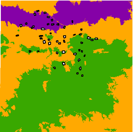
17 Landscape stratification Altitude & brighness

18 Best model selection for each strata
19 Model inversion for biomass estimation Estimation at pixel level Cotton Fresh biomass [qx/ha] >70
 Estimation for the 1023 fields Normalized mean")
 wrt in-situ measured biomass Crop type MAE")
20 RBM: Reference Biomass Map (field avg.) Estimation for the 1023 fields Normalized mean abs. err. (MAE) wrt in-situ measured biomass Crop type MAE (%) Sorghum Cotton 25.4 Maize Millet 11.03

21 Relatively good R 2 with SPOT (except Maize)

22 10-m resolution still catches spatial pattern Cotton Fresh biomass [qx/ha] >70
23 Impact of resolutions on biomass estimation Crop type MAE* 2-m res. (%) MAE* 10-m res. (%) Sorghum Cotton Maize / Millet Larger error at 10-m resolution *MAE = Normalized mean abs. err. (wrt in-situ measured biomass)

![biomass [qx/ha] 4-16 17-30](/docs-images/52/29437258/images/24-0.png "30-40 40-50 >50 +20 qx/ha due")
24 Impact of trees on biomass estimation Sorghum Fresh biomass [qx/ha] > qx/ha due to the trees
25 Impact of trees on biomass estimation Biomass difference wrt RBM General overestimation Field average biomass difference (qx/ha) Significant impact for Maize and Millet Biomass difference Crop type p-value overestimation (qx/ha) Sorghum Cotton Maize % Millet 3.6e %
 Crop type p-value Sorghum 0.306 Cotton 0.162 Field border Maize 0.774 Millet 4-m buffer 0.")
26 Impact of field border on biomass estimation Border mixels introduce noise in biomass estimation Field average biomass difference (qx/ha) Crop type p-value Sorghum Cotton Field border Maize Millet 4-m buffer Significant impact for Millet
27 Conclusions Unprecedented in-situ data & RS time series for 2 crop seasons Linear regression models allow good biomass estimation (11-25% error at 2-m res., 20-29% error at 10-m res.) Acquistion date is important - linked to crop calendar (crop & year specific) Stratification improves regression models (in heterogeneous landscape) Specific vegetation index per crop type & strata Biomass overestimated by trees in the field for millet-maize (20-29% resp.) Pixels in the field s border do impact biomass estimate only for millet
Introduction: Growth analysis and crop dry matter accumulation
 PBIO*3110 Crop Physiology Lecture #2 Fall Semester 2008 Lecture Notes for Tuesday 9 September How is plant productivity measured? Introduction: Growth analysis and crop dry matter accumulation Learning
Default & quality, performance But What s for?
 Training Workshop on SARRA-H Crop Model for English Speaking Meteorological Services in West Africa 24-28 FEBRUARY 214,, Banjul (Gambie) Default & quality, performance But What s for? Présenté par Christian
Big Data: Challenges in Agriculture. Big Data Summit, November 2014 Moorea Brega: Agronomic Modeling Lead The Climate Corporation
 Big Data: Challenges in Agriculture Big Data Summit, November 2014 Moorea Brega: Agronomic Modeling Lead The Climate Corporation Outline THE AGRICULTURAL CHALLENGE DATA SCIENCE MEETS AGRICULTURE THE ROLE
Dominique Courault 1 et al
 Dominique Courault 1 et al 1 AVIGNON 2 Toulouse UMR TETIS Montpellier UMR Innovation CEEP réserve Crau Fondation Tour du Valat 1 1 SPOT4 on the mediterranean region biodiversity orchard A wide variety
GEO Joint Experiment for Crop Assessment and Monitoring (JECAM): Template for Research Progress Report
: Template for Research Progress Report") GEO Joint Experiment for Crop Assessment and Monitoring (JECAM): Template for Research Progress Report Date: 17 th February 2015 JECAM Test Site Name: Bambey, Sénégal Team Leader and Members: Cirad Valérie
GEO Joint Experiment for Crop Assessment and Monitoring (JECAM): Template for Research Progress Report Date: 17 th February 2015 JECAM Test Site Name: Bambey, Sénégal Team Leader and Members: Cirad Valérie
Index Insurance for Climate Impacts Millennium Villages Project A contract proposal
 Index Insurance for Climate Impacts Millennium Villages Project A contract proposal As part of a comprehensive package of interventions intended to help break the poverty trap in rural Africa, the Millennium
Remote Sensing Applications for Precision Agriculture
 Remote Sensing Applications for Precision Agriculture Farm Progress Show Chris J. Johannsen, Paul G. Carter and Larry L. Biehl Department of Agronomy and Laboratory for Applications of Remote Sensing (LARS)
Rainfed agriculture evolution in a climate variability context of West Africa sudano- sahelian zone
 Rainfed agriculture evolution in a climate variability context of West Africa sudano- sahelian zone Drissa DIALLO, Université des Sciences, des Techniques et des Technologies de Bamako (USTTB) Bruno BARBIER,
Weather Indexed Crop Insurance Jared Brown, Justin Falzone, Patrick Persons and Heekyung Youn* University of St. Thomas
 Weather Indexed Crop Insurance Jared Brown, Justin Falzone, Patrick Persons and Heekyung Youn* University of St. Thomas Corresponding author: hkyoun@stthomas.edu 1. Introduction There has been a growing
Agroforestry and climate change. Emmanuel Torquebiau FAO webinar 5 February 2013
 Agroforestry and climate change Emmanuel Torquebiau FAO webinar 5 February 2013 Agroforestry: well-known buffering and resilience effects Climate variability is well buffered by agroforestry because of
Grain Sorghum Hybrid Tests in Tennessee
 Grain Sorghum Hybrid Tests in Tennessee 2010 Fred L. Allen, Coordinator, Agronomic Crop Variety Testing & Demonstrations Richard Johnson, Research Associate, Agronomic Crop Variety Testing & Demonstrations
VISUALIZATION OF A CROP SEASON THE INTEGRATION OF REMOTELY SENSED DATA AND SURVEY DATA
 VISUALIZATION OF A CROP SEASON THE INTEGRATION OF REMOTELY SENSED DATA AND SURVEY DATA Gail Wade GIS Analyst, Spatial Analysis Research Section George Hanuschak Chief, Geospatial Information Branch Research
AUTOMATED SOIL WATER TENSION-BASED DRIP IRRIGATION FOR PRECISE IRRIGATION SCHEDULING
 AUTOMATED SOIL WATER TENSION-BASED DRIP IRRIGATION FOR PRECISE IRRIGATION SCHEDULING Sabine Seidel sabine.seidel@tu-dresden.de Institute of Hydrology and Meteorology, Faculty of Environmental Sciences,
Nature Values Screening Using Object-Based Image Analysis of Very High Resolution Remote Sensing Data
 Nature Values Screening Using Object-Based Image Analysis of Very High Resolution Remote Sensing Data Aleksi Räsänen*, Anssi Lensu, Markku Kuitunen Environmental Science and Technology Dept. of Biological
IMAGINES_VALIDATIONSITESNETWORK ISSUE 1.00. EC Proposal Reference N FP7-311766. Name of lead partner for this deliverable: EOLAB
 Date Issued: 26.03.2014 Issue: I1.00 IMPLEMENTING MULTI-SCALE AGRICULTURAL INDICATORS EXPLOITING SENTINELS RECOMMENDATIONS FOR SETTING-UP A NETWORK OF SITES FOR THE VALIDATION OF COPERNICUS GLOBAL LAND
SatelliteRemoteSensing for Precision Agriculture
 SatelliteRemoteSensing for Precision Agriculture Managing Director WasatSp. z o.o. Copernicus the road to economic development Warsaw, 26-27 February 2015 Activitiesof WasatSp. z o.o. The company provides
Lake Monitoring in Wisconsin using Satellite Remote Sensing
 Lake Monitoring in Wisconsin using Satellite Remote Sensing D. Gurlin and S. Greb Wisconsin Department of Natural Resources 2015 Wisconsin Lakes Partnership Convention April 23 25, 2105 Holiday Inn Convention
Farmer Field Schools (FFS)
") Farmer Field Schools (FFS) Farmer to farmer experience sharing, mutual learning and dissemination of good practices for an improved agricultural production An experience from Food Security and Livelihoods
Farmer Field Schools (FFS) Farmer to farmer experience sharing, mutual learning and dissemination of good practices for an improved agricultural production An experience from Food Security and Livelihoods
Global environmental information Examples of EIS Data sets and applications
 METIER Graduate Training Course n 2 Montpellier - february 2007 Information Management in Environmental Sciences Global environmental information Examples of EIS Data sets and applications Global datasets
Index Insurance for Small-holder Agriculture:
 Index Insurance for Small-holder Agriculture: What We Have Learned about Impacts & Contract Design Michael R Carter Department of Agricultural & Resource Economics BASIS Assets & Market Access Research
Collaborative research project pre agro
 Collaborative research project pre agro Extraction of phenology-dependent structural information from hyperspectral, directional CHRIS data for a better derivation of canopy parameters of winter-wheat
Using Web-based Software for Irrigation and Nitrogen Management in Onion Production: our Research Plan for 2013
 Using Web-based Software for Irrigation and Nitrogen Management in Onion Production: our Research Plan for 2013 Andre Biscaro, Farm Advisor UCCE Los Angeles County Michael Cahn, Farm Advisor UCCE Monterey
Initial changes in hydrology and water quality following restoration of a shallow degraded peatland in the South west
 Initial changes in hydrology and water quality following restoration of a shallow degraded peatland in the South west David Luscombe 2 David Smith 1,, Emilie Grand-Clement 2, and Richard E. Brazier 2 1
Diffusion of Technologies Within Social Networks
 Working paper Diffusion of Technologies Within Social Networks Evidence from a Coffee Training Program in Rwanda Esther Duflo Tavneet Suri March 2010 IGC Contract RA 2010 03 001 Final Report 1. Introduction
Light Interception and Plant Growth. Photo courtesy of B.A. Stewart
 Light Interception and Plant Growth Photo courtesy of B.A. Stewart Physiological Determinants of Crop Growth D.A. Charles-Edwards (Academic Press, 1982) The acquisition of knowledge of the potential yield
Monitoring Overview with a Focus on Land Use Sustainability Metrics
 Monitoring Overview with a Focus on Land Use Sustainability Metrics Canadian Roundtable for Sustainable Crops. Nov 26, 2014 Agriclimate, Geomatics, and Earth Observation Division (ACGEO). Presentation
JECAM Site Ukraine. 21 23 July 2014. Team Leader: Kussul Nataliia. JECAM/GEOGLAM Science Meeting Ottawa, Canada
 Site Ukraine /GEOGLAM Science, Canada 21 23 July Team Leader: Kussul Nataliia Members: Shelestov Andrii, Skakun Sergii Site Description Kyiv oblast (SRI, area 28,000 km 2 ) & intensive observation sub-site
MS DATA ANALYSIS EXAM INSTRUCTIONS
 MS DATA ANALYSIS EXAM INSTRUCTIONS Please Read Carefully This exam consists of one question, with two parts. You are asked to write a report on your analyses and we strongly recommend that you begin writing
Update on Nitrogen Management Field Studies with Strawberries and Leafy Vegetables
 Update on Nitrogen Management Field Studies with Strawberries and Leafy Vegetables Mark Gaskell, Farm Advisor UCCE Santa Maria CAPCA Central Coast Meeting Nipomo, CA December 2, 2009 University of California
Evaluation of Biofertilizer and Manure Effects on Quantitative Yield of Nigella Sativa L.
 Evaluation of Biofertilizer and Manure Effects on Quantitative Yield of Nigella Sativa L. Mohammad Reza Haj Seyed Hadi Fereshteh Ghanepasand Mohammad Taghi Darzi Dept. of Agronomy, Roudehen Branch, Islamic
Irrigation Scheduling on Small Grains using AZSCHED for Windows - Safford Agricultural Center, 2003
 Irrigation Scheduling on Small Grains using AZSCHED for Windows - Safford Agricultural Center, 23 L.J. Clark and K.F. Ellsworth Abstract The AZSCHED irrigation scheduling software was developed in the
Plant Response to Irrigation Treatments in Arkansas Cotton
 Plant Response to Irrigation Treatments in Arkansas Cotton Sreekala G. Bajwa and Earl D. Vories 1 INTRODUCTION Irrigation of cotton has been increasing throughout the mid-south. In Arkansas, 65% of the
CIESIN Columbia University
 Conference on Climate Change and Official Statistics Oslo, Norway, 14-16 April 2008 The Role of Spatial Data Infrastructure in Integrating Climate Change Information with a Focus on Monitoring Observed
Using D2K Data Mining Platform for Understanding the Dynamic Evolution of Land-Surface Variables
 Using D2K Data Mining Platform for Understanding the Dynamic Evolution of Land-Surface Variables Praveen Kumar 1, Peter Bajcsy 2, David Tcheng 2, David Clutter 2, Vikas Mehra 1, Wei-Wen Feng 2, Pratyush
ESTIMATING YIELDS AND YIELD GAPS: Experiences from East Africa
 ESTIMATING YIELDS AND YIELD GAPS: Experiences from East Africa Godfrey Taulya, Lydia Wairegi, Piet van Asten PRESENTATION OUTLINE 1. General approach 2. Yield estimation in banana/plantain systems 3. On-farm
Session 3 - Innovations in Management of Agricultural and Weather Data
 Session 3 - Innovations in Management of Agricultural and Weather Data Nuno Meira Congrès International sur l'assurance et la réassurance des risques agricoles Marrakech, MAROC 29 au 31 janvier 2014 Agriculture
Landscape diversity and ecosystem services in agricultural ecosystems: implications for farmer s income
 Landscape diversity and ecosystem services in agricultural ecosystems: implications for farmer s income Xiangzheng Deng Chinese Academy of Sciences Sub-global Assessment Network Annual Meeting 26 th -29
GMES-DSL GMES - Downstream Service Land: Austria-Slovenia-Andalusia. Concept for a Harmonized Cross-border Land Information System.
 ERA-STAR Regions Project GMES-DSL GMES - Downstream Service Land: Austria-Slovenia-Andalusia. Concept for a Harmonized Cross-border Land Information System Executive Summary submitted by JOANNEUM RESEARCH,
Yield Response of Corn to Plant Population in Indiana
 Purdue University Department of Agronomy Applied Crop Production Research Update Updated May 2016 URL: http://www.kingcorn.org/news/timeless/seedingrateguidelines.pdf Yield Response of Corn to Plant Population
gebruiken voor aardse toepassingen
 26/03/2014 Satellietgegevens gebruiken voor aardse toepassingen Dirk Van Speybroeck dirk.vanspeybroeck@vito.be VITO, VIsion on TechnOlogy» een op Europees vlak toonaangevend, onafhankelijk onderzoeks-
Assets & Market Access (AMA) Innovation Lab. Tara Steinmetz, Assistant Director Feed the Future Innovation Labs Partners Meeting April 21, 2015
 Innovation Lab. Tara Steinmetz, Assistant Director Feed the Future Innovation Labs Partners Meeting April 21, 2015") Assets & Market Access (AMA) Innovation Lab Tara Steinmetz, Assistant Director Feed the Future Innovation Labs Partners Meeting April 21, 2015 Countries with Current AMA Innovation Lab Projects AMERICAS
Assets & Market Access (AMA) Innovation Lab Tara Steinmetz, Assistant Director Feed the Future Innovation Labs Partners Meeting April 21, 2015 Countries with Current AMA Innovation Lab Projects AMERICAS
Research Roadmap for the Future. National Grape and Wine Initiative March 2013
 Research Roadmap for the Future National Grape and Wine Initiative March 2013 Objective of Today s Meeting Our mission drives the roadmap Our Mission Drive research to maximize productivity, sustainability
Tennessee Watershed Modeling Tools. Southern Region Watershed Meeting, July 2005. Forbes Walker University of Tennessee Extension
 Tennessee Watershed Modeling Tools Southern Region Watershed Meeting, July 2005 Forbes Walker University of Tennessee Extension Outline Land Use and Water Quality in Tennessee Watershed models Watershed
ipot project Industrial Potato monitoring for the Belgian potato sector
 ipot project Industrial Potato monitoring for the Belgian potato sector Yannick Curnel, Jean-Pierre Goffart, Viviane Planchon (CRA-W) Version 25/04/2014 Financed by : BELSPO Project of 36 month 01/06/2014-31/05/2017
Maize is a major cereal grown and consumed in Uganda and in the countries of Kenya, Sudan, Democratic Republic of Congo and Rwanda
 Maize Production in Uganda Farmers have improved maize yields from 1,000Kg/ha to 3,000-5,000 Kg/ha using the recommended technologies Maize is a major cereal grown and consumed in Uganda and in the countries
Monitoring Global Crop Condition Indicators Using a Web-Based Visualization Tool
 Monitoring Global Crop Condition Indicators Using a Web-Based Visualization Tool Bob Tetrault, Regional Commodity Analyst, and Bob Baldwin, GIS Specialist, USDA, Foreign Agricultural Service, Washington,
GEOGG142 GMES Calibration & validation of EO products
 GEOGG142 GMES Calibration & validation of EO products Dr. Mat Disney mdisney@geog.ucl.ac.uk Pearson Building room 113 020 7679 0592 www.geog.ucl.ac.uk/~mdisney Outline Calibration & validation Example:
DESIGNING WEATHER INSURANCE CONTRACTS FOR FARMERS
 DESIGNING WEATHER INSURANCE CONTRACTS FOR FARMERS In Malawi, Tanzania and Kenya Excerpts from final report to the Commodity Risk Management Group, ARD, World Bank June 2007 Download the full report here:
The Kingdom of Mali. Read through the worksheet and allow for explanations and clarifications Discuss new terminology Learners complete the worksheet
 Grade 7, Term 1 Social Science: History Lesson Topic: The Kingdom of Mali Lesson 2 of 6 CAPS reference: page 33 Total time: 1 hour Aims Engage higher order thinking through questions Expand knowledge base
Rain on Planting Protection. Help Guide
 Rain on Planting Protection Help Guide overview Rain on Planting Protection allows growers to protect themselves from losses if rain prevents planting from being completed on schedule. Coverage is highly
Utilization of the Dark Green Color Index to Determine Cotton Nitrogen Status
 Utilization of the Dark Green Color Index to Determine Cotton Nitrogen Status T.B. Raper 1, D.M. Oosterhuis 1, U. Siddons 1, L.C. Purcell 1, and M. Mozaffari 2 RESEARCH PROBLEM Inadequate or excessive
Crop production. 0 5 10 15 million ha. 0 5 10 15 20 million tonnes PART 1. CHART 7: Harvested area of the most important crops in Central Asia (2010)
") PART 1 Crop production is the most important crop in the region of Europe and Central Asia. More than 80 million hectares of land are dedicated to growing wheat, of which 240 were produced in 2010. is
PART 1 Crop production is the most important crop in the region of Europe and Central Asia. More than 80 million hectares of land are dedicated to growing wheat, of which 240 were produced in 2010. is
Using Remote Sensing to Monitor Soil Carbon Sequestration
 Using Remote Sensing to Monitor Soil Carbon Sequestration E. Raymond Hunt, Jr. USDA-ARS Hydrology and Remote Sensing Beltsville Agricultural Research Center Beltsville, Maryland Introduction and Overview
Climate Change Vulnerability Assessment Tools and Methods
 Climate Change Vulnerability Assessment Tools and Methods Climate Finance Readiness Seminar Leif Kindberg Knowledge and Learning Manager, ARCC PRESENTATION OVERVIEW About ARCC Overview of Climate Change
College of Agricultural Sciences Agricultural Research and Cooperative Extension
 Start Farming Introduction to Soils Fact 4 Determining Nutrient Applications for Small Farms Basic Calculations Conventional Generally production systems in Pennsylvania use a mixture of nutrient sources.
Onderzoeksopdracht Beste landbouwpraktijken van teelten in combinatie met nateelten/vanggewassen
 Onderzoeksopdracht Beste landbouwpraktijken van teelten in combinatie met nateelten/vanggewassen Eindrapport 2 oktober 2014 Consortium Universiteit Gent ILVO Plant Inagro Bodemkundige Dienst van België
Agricultural Policies and Food Security Challenges in Zambia
 Agricultural Policies and Food Security Challenges in Zambia Auckland Kuteya Presentation at the Africa Lead Champions for Change Leadership Training, Protea Hotel, Chisamba, Zambia 16-20 th April, 2012
Automatic land-cover map production of agricultural areas using supervised classification of SPOT4(Take5) and Landsat-8 image time series.
 and Landsat-8 image time series.") Automatic land-cover map production of agricultural areas using supervised classification of SPOT4(Take5) and Landsat-8 image time series. Jordi Inglada 2014/11/18 SPOT4/Take5 User Workshop 2014/11/18
Automatic land-cover map production of agricultural areas using supervised classification of SPOT4(Take5) and Landsat-8 image time series. Jordi Inglada 2014/11/18 SPOT4/Take5 User Workshop 2014/11/18
Crop Drought Stress Monitoring by Remote Sensing (DROSMON) Overview. Werner Schneider
 Overview. Werner Schneider") Crop Drought Stress Monitoring by Remote Sensing (DROSMON) Overview Werner Schneider Institut of Surveying, Remote Sensing and Land Information Department of Landscape, Spatial and Infrastructure Sciences
Crop Drought Stress Monitoring by Remote Sensing (DROSMON) Overview Werner Schneider Institut of Surveying, Remote Sensing and Land Information Department of Landscape, Spatial and Infrastructure Sciences
Corporate stewardship Partnering to Improve Agricultural practices. Mumbai Randhir Chauhan
 Corporate stewardship Partnering to Improve Agricultural practices Mumbai Randhir Chauhan Flow of Presentation Agriculture in India Overview Present Challenges Why Sustainability? The Way Out Ensuring
U.S. Geological Survey Earth Resources Operation Systems (EROS) Data Center
 Data Center") U.S. Geological Survey Earth Resources Operation Systems (EROS) Data Center World Data Center for Remotely Sensed Land Data USGS EROS DATA CENTER Land Remote Sensing from Space: Acquisition to Applications
U.S. Geological Survey Earth Resources Operation Systems (EROS) Data Center World Data Center for Remotely Sensed Land Data USGS EROS DATA CENTER Land Remote Sensing from Space: Acquisition to Applications
Establishing a website to aid growers in harvesting and irrigation decisions: PeanutFARM
 Establishing a website to aid growers in harvesting and irrigation decisions: PeanutFARM D.L. ROWLAND 1, J.A. FERRELL 1, J.M. BENNETT 1, D.A. DREW 1, B.C. COLVIN 1, and W.H. FAIRCLOTH 2 1 Agronomy Department,
Practical Uses of Crop Monitoring for Arizona Cotton
 Practical Uses of Crop Monitoring for Arizona Cotton J. C. Silvertooth The use of crop monitoring and plant mapping has received a considerable amount of attention in the cotton production arena in recent
Heavy Metals in Cocoa
 Heavy Metals in Cocoa International Workshop on possible EU regulations on cadmium in cocoa and chocolate products 3rd & 4 th May Jayne Crozier www.cabi.org KNOWLEDGE FOR LIFE Project Aims To establish
Deficit Rainfall Insurance Payouts in Most Vulnerable Agro Climatic Zones of Tamil Nadu, India
 Deficit Rainfall Insurance Payouts in Most Vulnerable Agro Climatic Zones of Tamil Nadu, India S.Senthilnathan, K.Palanisami, C.R.Ranganathan and Chieko Umetsu 2 Tamil Nadu Agricultural University, Coimbatore,
Presentation of the Rural Polytechnic Institute for Training and Applied Research IPR/IFRA Katibougou. By Dr. Fafre Samake Director General
 Ministry of Education University of Mali Republic of Mali One People, One Goal, One Faith Presentation of the Rural Polytechnic Institute for Training and Applied Research IPR/IFRA Katibougou By Dr. Fafre
CROP CLASSIFICATION WITH HYPERSPECTRAL DATA OF THE HYMAP SENSOR USING DIFFERENT FEATURE EXTRACTION TECHNIQUES
 Proceedings of the 2 nd Workshop of the EARSeL SIG on Land Use and Land Cover CROP CLASSIFICATION WITH HYPERSPECTRAL DATA OF THE HYMAP SENSOR USING DIFFERENT FEATURE EXTRACTION TECHNIQUES Sebastian Mader
Paperless Processes from Underwriting to Claims Management
 Paperless Processes from Underwriting to Claims Management Bertus Kruger ABSA Insurance Company CONTENTS 1. Introduction of South Africa and ABSA 2. Background to Agricultural Crop Insurance in South Africa
Land Use/Land Cover Map of the Central Facility of ARM in the Southern Great Plains Site Using DOE s Multi-Spectral Thermal Imager Satellite Images
 Land Use/Land Cover Map of the Central Facility of ARM in the Southern Great Plains Site Using DOE s Multi-Spectral Thermal Imager Satellite Images S. E. Báez Cazull Pre-Service Teacher Program University
Benin. GAIN Report Number: Lagos
 THIS REPORT CONTAINS ASSESSMENTS OF COMMODITY AND TRADE ISSUES MADE BY USDA STAFF AND NOT NECESSARILY STATEMENTS OF OFFICIAL U.S. GOVERNMENT POLICY Voluntary - Public Date: 1/29/2013 GAIN Report Number:
World Water and Climate Atlas
 International Water Management Institute World Water and Climate Atlas Direct access to water and climate data improves agricultural planning The IWMI World Water and Climate Atlas provides rapid access
GEOENGINE MSc in Geomatics Engineering (Master Thesis) Anamelechi, Falasy Ebere
 Anamelechi, Falasy Ebere") Master s Thesis: ANAMELECHI, FALASY EBERE Analysis of a Raster DEM Creation for a Farm Management Information System based on GNSS and Total Station Coordinates Duration of the Thesis: 6 Months Completion
Master s Thesis: ANAMELECHI, FALASY EBERE Analysis of a Raster DEM Creation for a Farm Management Information System based on GNSS and Total Station Coordinates Duration of the Thesis: 6 Months Completion
Cultivating Agricultural Information Management System Using GIS Technology
 Hitachi Review Vol. 58 (2009), No. 6 265 Cultivating Agricultural Information Management System Using GIS Technology Improving Agricultural Efficiency through Information Technology Osamu Nishiguchi Noriko
A SOIL TESTING SERVICE FOR FARMERS IN THAILAND, USING MOBILE LABORATORIES
 A SOIL TESTING SERVICE FOR FARMERS IN THAILAND, USING MOBILE LABORATORIES Narong Chinabut Office of Science for Land Development Land Development Department, Ministry of Agriculture and Cooperatives, Bangkok
Multi-scale upscaling approaches of soil properties from soil monitoring data
 local scale landscape scale forest stand/ site level (management unit) Multi-scale upscaling approaches of soil properties from soil monitoring data sampling plot level Motivation: The Need for Regionalization
WATER AND DEVELOPMENT Vol. II - Types Of Environmental Models - R. A. Letcher and A. J. Jakeman
 TYPES OF ENVIRONMENTAL MODELS R. A. Letcher and A. J. Jakeman Centre for Resource and Environmental Studies, The Australian National University, Australia Keywords: environmental models, environmental
Precision Agriculture. Lucas Rios do Amaral Professor FEAGRI/UNICAMP Agronomist, PhD.
 Precision Agriculture Lucas Rios do Amaral Professor FEAGRI/UNICAMP Agronomist, PhD. August 04 th 2015 Conventional agriculture Deal with the entire are as it is homogeneous.. ...but it never is. Corn
ADAPTATION OF OPTICAL SENSORS TO DETECT URINE AND DUNG PATCHES IN DAIRY PASTURE
 ADAPTATION OF OPTICAL SENSORS TO DETECT URINE AND DUNG PATCHES IN DAIRY PASTURE Jemma Mackenzie 1, R Christianson 2, C Mackenzie 1 and I J Yule 2 1 Agri Optics NZ Ltd, 337 Reynolds Rd, RD 6, Ashburton,
Chapter 18 Introduction to. A f r i c a
 Chapter 18 Introduction to A f r i c a Ch. 18:1 Landforms & Resources 1. Africa s shape & landforms are the result of its location in the southern part of the ancient supercontinent of. Pangaea Over thousands
University of Florida Institute of Food and Agricultural Sciences. Gulf Coast Research and Education Center 5007 60th Street East Bradenton, FL 34203
 University of Florida Institute of Food and Agricultural Sciences Gulf Coast Research and Education Center 5007 60th Street East Bradenton, FL 34203 FINAL REPORT Submitted to the Southwest Florida Water
Introduction of Agro-meteorological Information Services In China. Prof. Wang Jianlin Dr. He Yanbo
 Introduction of Agro-meteorological Information Services In China Prof. Wang Jianlin Dr. He Yanbo National Meteorological center, China Meteorological Administration Contents Organization & Staff Members
Subsidence due to peat decomposition in the Netherlands kinematic observations from radar interferometry
 Subsidence due to peat decomposition in the Netherlands kinematic observations from radar interferometry Miguel Caro Cuenca, Ramon Hanssen, Freek van Leijen. Fringe 2007, Frascati, Italy Netherlands, Area
Highlights of Organic Issues within National Agric Policy (20013)
") Highlights of Organic Issues within National Agric Policy (20013) (Ministry of Agriculture Food Security and Cooperatives Tanzania By. Mibavu, G. M. 1 Outline i. Introduction ii. Opportunities on Organic
Highlights of Organic Issues within National Agric Policy (20013) (Ministry of Agriculture Food Security and Cooperatives Tanzania By. Mibavu, G. M. 1 Outline i. Introduction ii. Opportunities on Organic
Keywords: soil and water conservation, yield increase, cost-benefit, watershed management, food security.
 20 years of watershed management in Niger: approaches, impacts and economic aspects of large scale soil and water conservation measures Nill, D.; Ackermann, K; Schöning, A.; Trux, A.; van den Akker, E.;
GHANA Trade and Investment Program for a Competitive Export Economy. TIPCEE GIS Work February 2009
 GHANA Trade and Investment Program for a Competitive Export Economy TIPCEE GIS Work February 2009 TIPCEE Components TIPCEE GOAL Increased Competitiveness of Ghanaian Private Sector in Selected Industries
An Analytical Study on Production and Export of Fresh and Dry Fruits in Jammu and Kashmir
 International Journal of Scientific and Research Publications, Volume 3, Issue 2, February 213 1 An Analytical Study on Production and Export of Fresh and Dry Fruits in Jammu and Kashmir Naseer Ahmad Rather*,
Sequential cropping of Vertisols in the Ethiopian highlands using a broadbed-and-furrow system
 Sequential cropping of Vertisols in the Ethiopian highlands using a broadbed-and-furrow system ABIYE ASTATKE, SAMUEL JUTZI and ABATE TEDLA International Livestock Centre for Africa P.O. Box 5689, Addis
EFFECT OF SOWING DATE AND NPK FERTILIZER RATE ON YIELD AND YIELD COMPONENTS OF QUALITY PROTEIN MAIZE (Zea mays L.)
") EFFECT OF SOWING DATE AND NPK FERTILIZER RATE ON YIELD AND YIELD COMPONENTS OF QUALITY PROTEIN MAIZE (Zea mays L.) M. M. Jaliya 1, A. M. Falaki 2, M. Mahmud 2 and Y.A. Sani 1 1 National Agricultural Extension
EFFECT OF SOWING DATE AND NPK FERTILIZER RATE ON YIELD AND YIELD COMPONENTS OF QUALITY PROTEIN MAIZE (Zea mays L.) M. M. Jaliya 1, A. M. Falaki 2, M. Mahmud 2 and Y.A. Sani 1 1 National Agricultural Extension
Biogas-Lösungen für Kenias Agrarindustrie
 Biogas-Lösungen für Kenias Agrarindustrie Optimierung der Stromversorgung im kommerziellen und industriellen Sektor mit Erneuerbaren Energien in Kenia September, 2 nd, 2015, Berlin Dipl.-Ing. Walter Danner
MOVING FORWARD WITH LIDAR REMOTE SENSING: AIRBORNE ASSESSMENT OF FOREST CANOPY PARAMETERS
 MOVING FORWARD WITH LIDAR REMOTE SENSING: AIRBORNE ASSESSMENT OF FOREST CANOPY PARAMETERS Alicia M. Rutledge Sorin C. Popescu Spatial Sciences Laboratory Department of Forest Science Texas A&M University
Agricultural and Land Use: ENVISAT applications in Fujian Province
 Agricultural and Land Use: ENVISAT applications in Fujian Province Spatial Information Research Center, Fujian Province, Fuzhou University (http://www.sirc.) 2004-4-27 Main topics! About SIRC! The Chinese
Topic 13 Predictive Modeling. Topic 13. Predictive Modeling
 Topic 13 Predictive Modeling Topic 13 Predictive Modeling 13.1 Predicting Yield Maps Talk about the future of Precision Ag how about maps of things yet to come? Sounds a bit far fetched but Spatial Data
Environmental impacts of harvesting biomass from the Nordic forests. Nicholas Clarke Norwegian Forest and Landscape Institute
 1 Environmental impacts of harvesting biomass from the Nordic forests Nicholas Clarke Norwegian Forest and Landscape Institute Background 2 Increased use of forest biomass for energy might lead to conflict
Nature and Science, 3(1), 2005, Wang, et al, Water-saving and Anti-drought
, 2005, Wang, et al, Water-saving and Anti-drought") Nature and Science, 3(1),, Wang, et al, Water-saving and Anti-drought Water-saving and Anti-drought Combined Technological Measures Influences on Maize Yield Formation Factors and Water Utilization Efficiency
Nature and Science, 3(1),, Wang, et al, Water-saving and Anti-drought Water-saving and Anti-drought Combined Technological Measures Influences on Maize Yield Formation Factors and Water Utilization Efficiency
Water efficiency in agriculture
 CHAPTER 5 Water efficiency in agriculture Water efficiency of irrigation can be improved by making the right decisions regarding: Crop selection Irrigation scheduling Irrigation methods Source of water.
LiDAR for vegetation applications
 LiDAR for vegetation applications UoL MSc Remote Sensing Dr Lewis plewis@geog.ucl.ac.uk Introduction Introduction to LiDAR RS for vegetation Review instruments and observational concepts Discuss applications
Emmanuel Tumusiime-Mutebile: The challenge of modernising smallholder agriculture in East Africa
 Emmanuel Tumusiime-Mutebile: The challenge of modernising smallholder agriculture in East Africa Keynote address by Mr Emmanuel Tumusiime-Mutebile, Governor of the Bank of Uganda, at the International
Establishing ecologically sustainable forest biomass supply chains: A case study in the boreal forest of Canada
 Establishing ecologically sustainable forest biomass supply chains: A case study in the boreal forest of Canada Evelyne Thiffault Canadian Forest Service David Paré Canadian Forest Service Sylvain Volpé
Guidance on Efficacy information in the core submission and national Addenda Anses DGAl
 Guidance on Efficacy information in the core submission and national Addenda Anses DGAl 1 Joint presentation by the French authorities : Anses, french Agency, for food, environmental, and occupational
NEW GEN SUPPORT SYSTEM FOR AGRICULTURAL CROPS FOR KANCHEEPURAM DISTRICT SOUTH INDIA
 NEW GEN SUPPORT SYSTEM FOR AGRICULTURAL CROPS FOR KANCHEEPURAM DISTRICT SOUTH INDIA D. Soundarrajan 1, Priyadharshini 2, Dr.M.M.Vijayalakshmi 3, Dr.E. Natarajan 4 1 Research Scholar, 3 Professor, Department