Or, I m lost. How do I find my way back to the trailhead?
|
|
|
- Stephanie McKenzie
- 7 years ago
- Views:
Transcription
1 Or, I m lost. How do I find my way back to the trailhead?
2 Read topographic maps Understand geographic coordinate system (Lat, Lon) Plot Lat/Lon coordinates on maps Read Lat/Lon coordinates off maps See demo of Google Earth Understand UTM coordinate system Plot UTM coordinates maps Read UTM coordinates off maps See demo of National Geographic TOPO! Software Learn how to download tracks to your GPS Begin geocaching competition
3 Garmin: Larry Linderman Michael Reale Ray Gearhard Cheryl Werstler Bill Leightenheimer Delorme: Randy Park Magellan: Walt Shields Will also help you during exercises
4
5
6
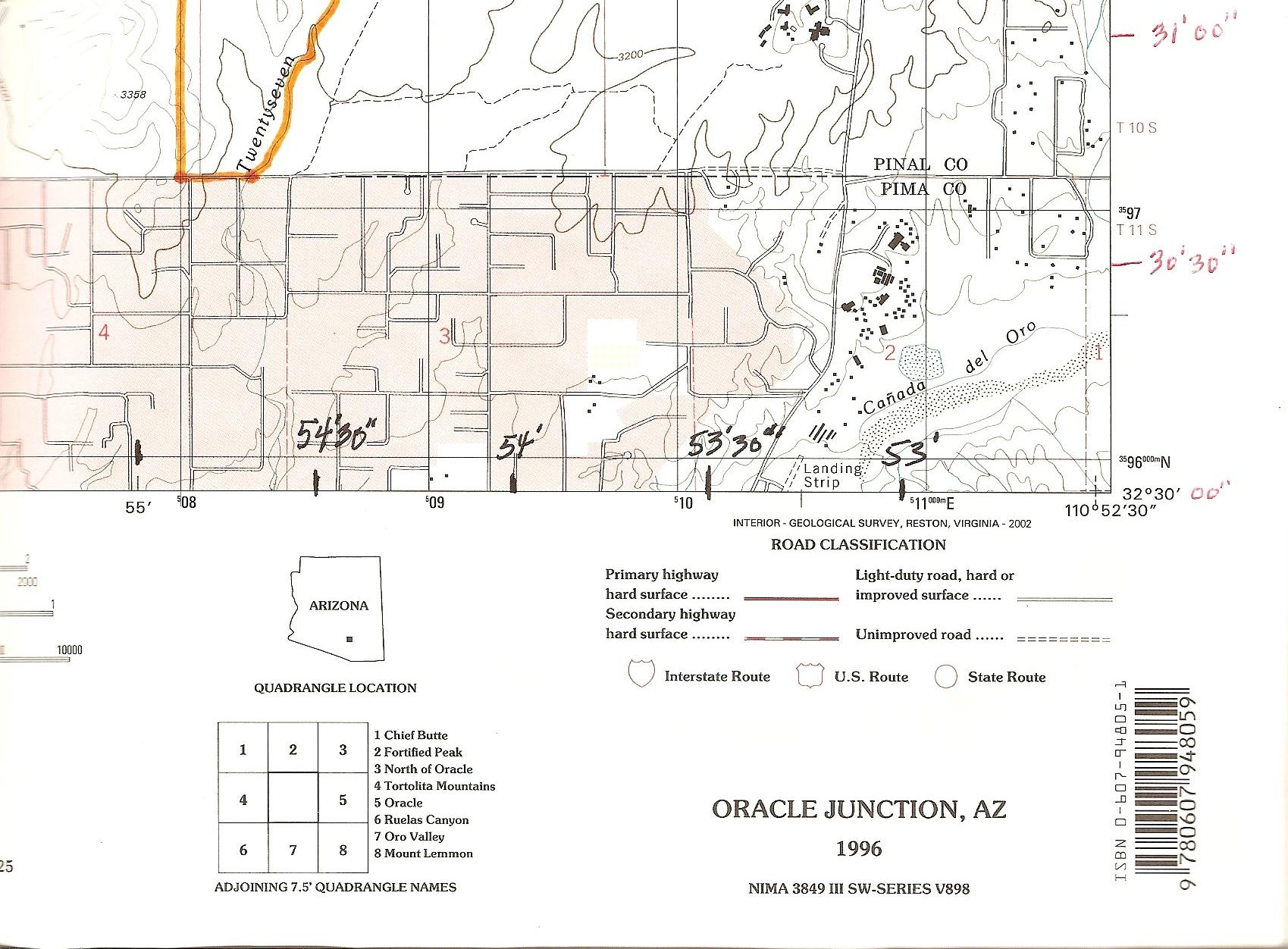
7 USGS Quadrangles are best Show both latitude and longitude, and Universal Transverse Mercator (UTM) coordinates True north orientation but shows magnetic north Shows natural features like streams, lakes, forest cover Also shows basic manmade features, i.e., roads, towers, buildings (which may be grossly out of date) Distance scales Key to adjacent maps
8 1:24,000 quad maps are the most detailed, but less detailed scales are available (What does 1:24,000 mean?) Quad maps are 7.5 minute rectangles (why aren t they square?) Contour lines (i.e., lines of equal elevation) are 40 feet apart Degrees: 0 to 360, minutes:0 to 60, seconds: 0 to 60 How many quad maps would be needed to circle the earth? (360 x (60/7.5)) = 2880 one quad high Over 1900 quads are needed to cover Arizona Typical quad maps for Tucson area is about 7.3 miles wide and 8.6 miles high

9

10
11
12
13 Between BM 3226 and Catalina Park in miles Between BM 3226 and ctr. Of Chalk Reservoir in miles Between Deep Well and Indian Town Reservoir in miles Between Deep Well and the intersection of Edwin Rd and Oracle Rd in Km Between Deep Well and the closest point on Rail X Rd in Km Between BM 3226 and the NW corner of Catalina in Km
14 Between BM 3226 and Catalina Park in miles (1.2) Between BM 3226 and ctr. Of Chalk Reservoir in miles ( 2.3) Between Deep Well and Indian Town Reservoir in miles (2.4) Between Deep Well and the intersection of Edwin Rd and Oracle Rd in Km (4.4) Between Deep Well and the closest point on Rail X Rd in Km (2.1) Between BM 3226 and the NW corner of Catalina in Km (1.6)
15
16 Between BM 3226 and Catalina Park Between BM 3226 and ctr. Of Chalk Reservoir Between Deep Well and Indian Town Reservoir Between Deep Well and the closest point on Edwin Road Between Deep Well and the closest point on Rail X Rd. Between BM 3226 and the NW corner of Catalina
17 Between BM 3226 and Catalina Park (66) Between BM 3226 and ctr. Of Chalk Reservoir (74) Between Deep Well and Indian Town Reservoir (110) Between Deep Well and the intersection of Edwin Rd & Oracle Rd (185) Between Deep Well and the closest point on Rail X Rd. (70) Between BM 3226 and the red number 28 (260)
18 Geographic: Latitude and Longitude Measured in degrees, minutes, and seconds There are 60 seconds in a minute and 60 minutes in a degree. There are 360 degrees around the earth Map grid is marked every 2 minutes and 30 seconds on 1:24,000 USGS quad maps Grid based: UTM Measured in meters Map grid is marked every 1000 meters (1 kilometer) on 1:24,000 USGS quad maps
19 UTM 12 S , Latitude, Longitude (degrees, minutes, seconds) N 32 o , W 110 o Latitude, Longitude (degrees & fractions of degrees) N o, W o Latitude Longitude (degrees & fractions of minutes) N 32 o 31.66, 110 o 53.32


20 E N
21
22 A line passing to the rear of the Royal Observatory, Greenwich, UK has been chosen as the international zero-longitude reference line, the Prime Meridian. Places to the east are in the eastern hemisphere, and places to the west are in the western hemisphere. The equator is the point of origin for latitude expressions. Units for Latitude & Longitude Seconds range from 0 to 60 Minutes range from 0 to 60 Degrees range from 0 o to 360 0
 In Tucson, longitude is roughly 111 degrees west of zero.")
23 Magnetic vs. true north (11.5 deg in Tucson) In Tucson, longitude is roughly 111 degrees west of zero. In Tucson, latitude is roughly 32 degrees north of zero.
24 Plot several locations using Lat Lon coordinates Provide handout map and give coordinates Follow up with on-screen location answer, guides provide over-the-shoulder help
OBJECTIVES. Identify the means by which latitude and longitude were created and the science upon which they are based.
 Name: Key OBJECTIVES Correctly define: isolines, gradient, topographic map, contour interval, hachured lines, profile, latitude, longitude, hydrosphere, lithosphere, atmosphere, elevation, model EARTH
Learning about GPS and GIS
 Learning about GPS and GIS Standards 4.4 Understand geographic information systems (G.I.S.). B12.1 Understand common surveying techniques used in agriculture (e.g., leveling, land measurement, building
Topographic Maps Practice Questions and Answers Revised October 2007
 Topographic Maps Practice Questions and Answers Revised October 2007 1. In the illustration shown below what navigational features are represented by A, B, and C? Note that A is a critical city in defining
Searching Land Records thru the BLM General Land Office Records.
 Searching Land Records thru the BLM General Land Office Records. Land Records can be an exciting addition to your family history search. The United States Government transferred ownership of land to millions
Earth Coordinates & Grid Coordinate Systems
 Earth Coordinates & Grid Coordinate Systems How do we model the earth? Datums Datums mathematically describe the surface of the Earth. Accounts for mean sea level, topography, and gravity models. Projections
UTM: Universal Transverse Mercator Coordinate System
 Practical Cartographer s Reference #01 UTM: Universal Transverse Mercator Coordinate System 180 174w 168w 162w 156w 150w 144w 138w 132w 126w 120w 114w 108w 102w 96w 90w 84w 78w 72w 66w 60w 54w 48w 42w
Plotting Earthquake Epicenters an activity for seismic discovery
 Plotting Earthquake Epicenters an activity for seismic discovery Tammy K Bravo Anne M Ortiz Plotting Activity adapted from: Larry Braile and Sheryl Braile Department of Earth and Atmospheric Sciences Purdue
Topo Grabber Help. 2010 Fountain Computer Products
 Topo Grabber Help Topo Grabber Help All rights reserved. No parts of this work may be reproduced in any form or by any means - graphic, electronic, or mechanical, including photocopying, recording, taping,
World Map Lesson 4 - The Global Grid System - Grade 6+
 World Map Lesson 4 - The Global Grid System - Grade 6+ Activity Goal To use the global grid system of latitude and longitude to find specific locations on a world map. Materials Needed: A pencil, a ruler,
UTM Zones for the US UTM UTM. Uniform strips Scalable coordinates
 UTM UTM Uniform strips Scalable coordinates Globally consistent, most popular projection/coordinate system for regional to global scale geospatial data (i.e. satellite images global scale datasets USGS/EDC)
Lines on Maps and Globes. Cross Curricular Writing Activity Social Studies Grade 4
 Lines on Maps and Globes Cross Curricular Writing Activity Social Studies Grade 4 Fourth Grade Social Studies Standard Map: Chart/Globe The learner will be able to use maps, charts, graphs, and globes
Basic Map & GPS Skills. How to read a topographic map, use a compass, and determine GPS locations on a map
 Basic Map & GPS Skills How to read a topographic map, use a compass, and determine GPS locations on a map Table of Contents This booklet covers what a topographic map (topo map) is, how to use a map, and
EPSG. Coordinate Reference System Definition - Recommended Practice. Guidance Note Number 5
 European Petroleum Survey Group EPSG Guidance Note Number 5 Coordinate Reference System Definition - Recommended Practice Revision history: Version Date Amendments 1.0 April 1997 First release. 1.1 June
Grades 3-5. Benchmark A: Use map elements or coordinates to locate physical and human features of North America.
 Grades 3-5 Students use knowledge of geographic locations, patterns and processes to show the interrelationship between the physical environment and human activity, and to explain the interactions that
The Globe Latitudes and Longitudes
 INDIAN SCHOOL MUSCAT MIDDLE SECTION DEPARTMENT OF SOCIAL SCIENCE The Globe Latitudes and Longitudes NAME: CLASS VI SEC: ROLL NO: DATE:.04.2015 I NAME THE FOLLOWING: 1. A small spherical model of the Earth:
Basic Steps to Using the Wildlife Application
 Basic Steps to Using the Wildlife Application The intent of the Wildlife Application (http://gisweb1.serm.gov.sk.ca/wildlifelogin/form.asp) is to provide a tool to search an area in the province of Saskatchewan
ACTIVITY 1 Hemispheres of the World
 Name Date Class CTIVITY 1 s of the World Directions: Use your textbook to answer the questions below. 1. What line of latitude is used to divide the earth into Northern and Southern s? 2. What line of
Motion & The Global Positioning System (GPS)
") Grade Level: K - 8 Subject: Motion Prep Time: < 10 minutes Duration: 30 minutes Objective: To learn how to analyze GPS data in order to track an object and derive its velocity from positions and times.
Grade Level: K - 8 Subject: Motion Prep Time: < 10 minutes Duration: 30 minutes Objective: To learn how to analyze GPS data in order to track an object and derive its velocity from positions and times.
An Introduction to Coordinate Systems in South Africa
 An Introduction to Coordinate Systems in South Africa Centuries ago people believed that the earth was flat and notwithstanding that if this had been true it would have produced serious problems for mariners
Sun Earth Relationships
 1 ESCI-61 Introduction to Photovoltaic Technology Sun Earth Relationships Ridha Hamidi, Ph.D. Spring (sun aims directly at equator) Winter (northern hemisphere tilts away from sun) 23.5 2 Solar radiation
Measuring the Earth Using a GPS M. Scott Wilkerson & M. Beth Wilkerson, DePauw University, May 10, 2007
 Measuring the Earth Using a GPS M. Scott Wilkerson & M. Beth Wilkerson, DePauw University, May 10, 2007 Modified from: Kerski, J.J., 2007, Measuring the Earth s Circumference with GPS, Copyright ESRI,
Coordinate Systems. Orbits and Rotation
 Coordinate Systems Orbits and Rotation Earth orbit. The earth s orbit around the sun is nearly circular but not quite. It s actually an ellipse whose average distance from the sun is one AU (150 million
Maps A Primer for Content & Production of Topographic Base Maps For Design Presented by SurvBase, LLC
 Maps A Primer for Content & Production of Topographic Base Maps For Design Presented by Definition and Purpose of, Map: a representation of the whole or a part of an area. Maps serve a wide range of purposes.
THE UNIVERSAL GRID SYSTEM
 NGA Office of GEOINT Sciences Coordinate Systems Analysis (CSAT) Phone: 314-676-9124 Unclassified Email: coordsys@nga.mil March 2007 THE UNIVERSAL GRID SYSTEM Universal Transverse Mercator (UTM) Military
量 說 Explanatory Notes on Geodetic Datums in Hong Kong
 量 說 Explanatory Notes on Geodetic Datums in Hong Kong Survey & Mapping Office Lands Department 1995 All Right Reserved by Hong Kong Government 留 CONTENTS INTRODUCTION............... A1 HISTORICAL BACKGROUND............
The Basics of Navigation
 The Basics of Navigation Knowledge of map reading and the use of the compass is an indispensable skill of bushcraft. Without this skill, a walker is a passenger and mere follower on a trip. To become a
Basic Elements of Reading Plans
 Center for Land Use Education and Research at the University of Connecticut Basic Elements of Reading Plans University of Connecticut. The University of Connecticut supports all state and federal laws
GEOGRAPHIC INFORMATION SYSTEMS Lecture 11: Land Division Systems
 GEOGRAPHIC INFORMATION SYSTEMS Lecture 11: Land Division Systems Land Division Systems - in many applications of GIS, land ownership is an important data layer and it is important for GIS users to be familiar
Lecture 2. Map Projections and GIS Coordinate Systems. Tomislav Sapic GIS Technologist Faculty of Natural Resources Management Lakehead University
 Lecture 2 Map Projections and GIS Coordinate Systems Tomislav Sapic GIS Technologist Faculty of Natural Resources Management Lakehead University Map Projections Map projections are mathematical formulas
Legal Descriptions. Chapter 9
 Legal Descriptions Chapter 9 Legal Description Defined A description of land is legally sufficient if it allows a competent surveyor to locate the parcel. This means locate and define boundaries 2 When
Module 11: The Cruise Ship Sector. Destination #3
 Module 11: The Cruise Ship Sector Destination #3 Cruise Destinations Welcome to your third destination. Use the following resource article to learn about the different oceans and time zones. Seen from
CONTENTS INTRODUCTION... 1 UNIT 1. PURPOSE OF MAPS... 3 1.1 MAP DEFINITION 1.2 MAP ACCURACY UNIT 2. CLASSIFICATION OF MAPS... 5 2.1 CATEGORIES 2.
 CONTENTS INTRODUCTION... 1 UNIT 1. PURPOSE OF MAPS... 3 1.1 MAP DEFINITION 1.2 MAP ACCURACY UNIT 2. CLASSIFICATION OF MAPS... 5 2.1 CATEGORIES 2.2 U.S. GEOLOGICAL SURVEY UNIT 3. MAP LEGEND... 9 3.1 MAP
Finding location and velocity data for PBO GPS stations
 Finding location and velocity data for PBO GPS stations Original activity by Vince Cronin (Baylor University). Revisions by Beth Pratt-Sitaula (UNAVCO). Analyzing the velocities recorded at different GPS
A Beginner s Step by Step Guide to Geocaching
 A Beginner s Step by Step Guide to Geocaching Geocaching is a great motivator to get outside and do some exploring, get some exercise and learn about areas you might otherwise never visit. You can think
CHAPTER 4 LEGAL DESCRIPTION OF LAND DESCRIBING LAND METHODS OF DESCRIBING REAL ESTATE
 r CHAPTER 4 LEGAL DESCRIPTION OF LAND DESCRIBING LAND A legal description is a detailed way of describing a parcel of land for documents such as deeds and mortgages that will be accepted in a court of
Graphic Information Systems
 Orienteering In Schools Orienteering and Technology Part III Graphic Information Systems GREG SACK, OCIN In an article titled Geographic Information Systems in the Classroom published by ElementK Journals
Chapter 9 Questions Legal Descriptions
 Chapter 9 Questions Legal Descriptions 1. How many acres are in a lot that is 1/4 of a mile wide by 1/4 of a mile long? a. 10 b. 120 c. 40 d. 80 2. The numbering of sections in a township begins in the
Metadata for Big River Watershed Geologic and Geomorphic Data
 Metadata for Big River Watershed Geologic and Geomorphic Data Metadata are descriptions and information regarding compiled data. This appendix contains the metadata that describes the compiled data used
6. The greatest atmospheric pressure occurs in the 1) troposphere 3) mesosphere 2) stratosphere 4) thermosphere
 troposphere 3) mesosphere 2) stratosphere 4) thermosphere") 1. The best evidence of the Earth's nearly spherical shape is obtained through telescopic observations of other planets photographs of the Earth from an orbiting satellite observations of the Sun's altitude
1. The best evidence of the Earth's nearly spherical shape is obtained through telescopic observations of other planets photographs of the Earth from an orbiting satellite observations of the Sun's altitude
3D Visualization of Seismic Activity Associated with the Nazca and South American Plate Subduction Zone (Along Southwestern Chile) Using RockWorks
 Using RockWorks") 3D Visualization of Seismic Activity Associated with the Nazca and South American Plate Subduction Zone (Along Southwestern Chile) Using RockWorks Table of Contents Figure 1: Top of Nazca plate relative
3D Visualization of Seismic Activity Associated with the Nazca and South American Plate Subduction Zone (Along Southwestern Chile) Using RockWorks Table of Contents Figure 1: Top of Nazca plate relative
Stage 4. Geography. Blackline Masters. By Karen Devine
 1 Devine Educational Consultancy Services Stage 4 Geography Blackline Masters By Karen Devine Updated January 2010 2 This book is intended for the exclusive use in NSW Secondary Schools. It is meant to
ELEMENTS OF SURVEYING FOR CADASTRAL MAPPING
 ELEMENTS OF SURVEYING FOR CADASTRAL MAPPING Chapter 4 2015 Cadastral Mapping Manual 4-0 Elements of Surveying and Mapping Utah's system of land surveying is the rectangular survey system as set forth on
Geography I Pre Test #1
 Geography I Pre Test #1 1. The sun is a star in the galaxy. a) Orion b) Milky Way c) Proxima Centauri d) Alpha Centauri e) Betelgeuse 2. The response to earth's rotation is a) an equatorial bulge b) polar
CHAPTER 9 SURVEYING TERMS AND ABBREVIATIONS
 CHAPTER 9 SURVEYING TERMS AND ABBREVIATIONS Surveying Terms 9-2 Standard Abbreviations 9-6 9-1 A) SURVEYING TERMS Accuracy - The degree of conformity with a standard, or the degree of perfection attained
DOMINION LAND SURVEY. COMPOSED AND PRODUCED BY : Chris Rule. Permission is granted for use by acknowledging the author s name.
 COMPOSED AND PRODUCED BY : Chris Rule Permission is granted for use by acknowledging the author s name. The Dominion Land Survey System was initiated by the Canadian Government in 1869 for settlement purposes.
delorme.com/earthmate Earthmate A Guide to the Complete GPS Navigation Solution for Smartphones and Tablets.
 delorme.com/earthmate Earthmate A Guide to the Complete GPS Navigation Solution for Smartphones and Tablets. EARTHMATE I N C L U D E D A guide to Earthmate Hunt Edition is included in this document. Earthmate
EARTH SCIENCES - TYPES OF MAPS TEACHER GUIDE
 EARTH SCIENCES - TYPES OF MAPS TEACHER GUIDE MATERIALS: Electronic Reader - Maps 5 different types of maps (see lab) inflatable globes local topographical map Objective: To understand the uses and importance
CELESTIAL CLOCK - THE SUN, THE MOON, AND THE STARS
 INTRODUCTION CELESTIAL CLOCK - THE SUN, THE MOON, AND THE STARS This is a scientific presentation to provide you with knowledge you can use to understand the sky above in relation to the earth. Before
Getting Land Survey Vertical & Horizontal Control via the Internet
 Getting Land Survey Vertical & Horizontal Control via the Internet https://www.auroragov.org aka: City of Aurora home page ROLL OVER City Hall Dropdown will appear 1 PICK Maps In the Info List 2 PICK Mapping
Lecture 4: Streamflow and Stream Gauging
 Lecture 4: Streamflow and Stream Gauging Key Questions 1. What is stream discharge and what controls its magnitude? 2. What is a hydrograph? 3. Where is the velocity highest in a stream? 4. Where is the
Stellarium a valuable resource for teaching astronomy in the classroom and beyond
 Stellarium 1 Stellarium a valuable resource for teaching astronomy in the classroom and beyond Stephen Hughes Department of Physical and Chemical Sciences, Queensland University of Technology, Gardens
Data Collection and Reporting Tool Training Presentation
 Data Collection and Reporting Tool Training Presentation 1 Table of Contents Introduction to the tool: Slides 3-9 How to use the tool General Information: Slides 11-14 Country Coordinator: Slides 15-35
Stream Channel Cross Sections for a Reach of the Boise River in Ada County, Idaho
 U.S. Department of the Interior U.S. Geological Survey In cooperation with Federal Emergency Management Agency, City of Boise, City of Garden City, City of Eagle, and Ada County Stream Channel Cross Sections
How do you compare numbers? On a number line, larger numbers are to the right and smaller numbers are to the left.
 The verbal answers to all of the following questions should be memorized before completion of pre-algebra. Answers that are not memorized will hinder your ability to succeed in algebra 1. Number Basics
Review 1. Multiple Choice Identify the choice that best completes the statement or answers the question.
 Review 1 Multiple Choice Identify the choice that best completes the statement or answers the question. 1. When hydrogen nuclei fuse into helium nuclei a. the nuclei die. c. particles collide. b. energy
Using Geocoded TIFF & JPEG Files in ER Mapper 6.3 with SP1. Eric Augenstein Earthstar Geographics Web: www.es-geo.com
 Using Geocoded TIFF & JPEG Files in ER Mapper 6.3 with SP1 Eric Augenstein Earthstar Geographics Web: www.es-geo.com 1 Table of Contents WHAT IS NEW IN 6.3 SP1 REGARDING WORLD FILES?...3 WHAT IS GEOTIFF
PART 6 MAPPING CHAPTER 1 ASSESSMENT MAPPING PARCELING STANDARDS AND ASSESSMENT PROCEDURES MANUAL. DEPARTMENT OF REVENUE Property Tax Division
 Parceling Stards PART 6 MAPPING CHAPTER 1 ASSESSMENT MAPPING AND PARCELING STANDARDS 6.1.1 Parceling Stards INTRODUCTION As computerized mapping has moved into the mainstream, the sharing of geographic
Latitude, Longitude, and Time Zones
 Latitude, Longitude, and Time Zones Typical Graph This is an example of a typical graph. It is made up of points that are connected by a line. Y axis Typical Graph Each point has two values: (4,7) An X
EPS 101/271 Lecture 11: GPS Data Collection, Mapping Using GPS and Uncertainties in GPS Positioning
 EPS 101/271 Lecture 11: GPS Data Collection, Mapping Using GPS and Uncertainties in GPS Positioning How GPS data is collected in GeoMapper Setting Time interval for reporting GPS measurements Modes of
Solar Angles and Latitude
 Solar Angles and Latitude Objectives The student will understand that the sun is not directly overhead at noon in most latitudes. The student will research and discover the latitude ir classroom and calculate
PLOTTING SURVEYING DATA IN GOOGLE EARTH
 PLOTTING SURVEYING DATA IN GOOGLE EARTH D M STILLMAN Abstract Detail surveys measured with a total station use local coordinate systems. To make the data obtained from such surveys compatible with Google
4 The Rhumb Line and the Great Circle in Navigation
 4 The Rhumb Line and the Great Circle in Navigation 4.1 Details on Great Circles In fig. GN 4.1 two Great Circle/Rhumb Line cases are shown, one in each hemisphere. In each case the shorter distance between
Earth In Space Chapter 3
 Earth In Space Chapter 3 Shape of the Earth Ancient Greeks Earth casts a circular shadow on the moon during a lunar eclipse Shape of the Earth Ancient Greeks Ships were observed to disappear below the
WILD 3710 Lab 3: GIS Data Exploration Camp W.G. Williams
 WILD 3710 Lab 3: GIS Data Exploration Camp W.G. Williams -Laboratory- TAs and Lab Instructors: Chris McGinty chris@gis.usu.edu Office: JQL 146 Office Hours: W 2:30 3:30 or by appt. Alex Hernandez alex@gis.usu.edu
Georeferencing and Google Earth. Cyberinfrastructure: Specimen Databases: Day 5 Brigette Zacharczenko
 Georeferencing and Google Earth Cyberinfrastructure: Specimen Databases: Day 5 Brigette Zacharczenko 1 Georeferencing standards Georeferencing of legacy data Georeferencing exercise Mapping data Using
NGA GRID GUIDE HOW TO USE ArcGIS 8.x ANS 9.x TO GENERATE MGRS AND OTHER MAP GRIDS
 GEOSPATIAL SCIENCES DIVISION COORDINATE SYSTEMS ANALYSIS TEAM (CSAT) SEPTEMBER 2005 Minor Revisions March 2006 POC Kurt Schulz NGA GRID GUIDE HOW TO USE ArcGIS 8.x ANS 9.x TO GENERATE MGRS AND OTHER MAP
Introduction to GIS (Basics, Data, Analysis) & Case Studies. 13 th May 2004. Content. What is GIS?
 & Case Studies. 13 th May 2004. Content. What is GIS?") Introduction to GIS (Basics, Data, Analysis) & Case Studies 13 th May 2004 Content Introduction to GIS Data concepts Data input Analysis Applications selected examples What is GIS? Geographic Information
Introduction to GIS (Basics, Data, Analysis) & Case Studies 13 th May 2004 Content Introduction to GIS Data concepts Data input Analysis Applications selected examples What is GIS? Geographic Information
Fugawi Global Navigator Ver. 4.5 GPS Moving Map Software
 Fugawi Global Navigator Ver. 4.5 GPS Moving Map Software Fugawi Global Navigator is the ideal PC software tool for route planning, GPS programming, and real-time GPS navigation on land, sea and in the
FM 3-25.26 MAP READING AND LAND NAVIGATION
 *FM 3-25.26 (FM 21-26) Field Manual No. 3-25.26 Headquarters Department of the Army Washington, DC, 20 July 2001 FM 3-25.26 MAP READING AND LAND NAVIGATION Table of Contents PREFACE Part One MAP READING
The Earth Really is Flat! The Globe and Coordinate Systems. Long History of Mapping. The Earth is Flat. Long History of Mapping
 The Earth Really is Flat! The Globe and Coordinate Systems Intro to Mapping & GIS The Earth is Flat Day to day, we live life in a flat world sun rises in east, sets in west sky is above, ground is below
SECOND GRADE 1 WEEK LESSON PLANS AND ACTIVITIES
 SECOND GRADE 1 WEEK LESSON PLANS AND ACTIVITIES UNIVERSE CYCLE OVERVIEW OF SECOND GRADE UNIVERSE WEEK 1. PRE: Discovering stars. LAB: Analyzing the geometric pattern of constellations. POST: Exploring
Celestial Observations
 Celestial Observations Earth experiences two basic motions: Rotation West-to-East spinning of Earth on its axis (v rot = 1770 km/hr) (v rot Revolution orbit of Earth around the Sun (v orb = 108,000 km/hr)
Newton s Law of Gravity
 Gravitational Potential Energy On Earth, depends on: object s mass (m) strength of gravity (g) distance object could potentially fall Gravitational Potential Energy In space, an object or gas cloud has
Maps in H2OCIS. Subject: Current and Future Mapping Functionality in H2OCIS. Author: Cathal Brady. Date Published: 01/11/2011
 Maps in H2OCIS Subject: Current and Future Mapping Functionality in H2OCIS Author: Cathal Brady Date Published: 01/11/2011 Version Number: Draft - Version 0.1 Contents 1 Introduction... 2 2 The Map Dashboard...
Weekend Cabin Retreat Project Site Plans
 Weekend Cabin Retreat Project Site Plans Sacramento City College EDT 300/ENGR 306 EDT 300/ENGR 306 - Site Plans 1 Cabin Project Site Plan/Bubble Diagram - Assignment 1 =10-0 Floor Plan - Assignment 1/4
SPEED, VELOCITY, AND ACCELERATION
 reflect Look at the picture of people running across a field. What words come to mind? Maybe you think about the word speed to describe how fast the people are running. You might think of the word acceleration
compass Encyclopedic Entry
 This website would like to remind you: Your browser (Apple Safari 7) is out of date. Update your browser for more security, comfort and the best experience on this site. Encyclopedic Entry compass For
Give students a lesson in navigation from the points of the compass to GPS mapping.
 Lesson 5: Teaching Directions, Maps, and Coordinates Give students a lesson in navigation from the points of the compass to GPS mapping. by Jenny Parma; curriculum by Diane Petersen and Karen Dvornich
CONTENTS. Page 3 What is orienteering? Page 4 Activity: orienteering map bingo. Page 5 Activity: know your colours. Page 6 Choosing your compass
 THE RIGHT DIRECTION SCOUT ORIENTEER ACTIVITY BADGE CONTENTS Page What is orienteering? Page 4 Activity: orienteering map bingo Page 5 Activity: know your colours Page 6 Choosing your compass Page 7 Activity:
Create a folder on your network drive called DEM. This is where data for the first part of this lesson will be stored.
 In this lesson you will create a Digital Elevation Model (DEM). A DEM is a gridded array of elevations. In its raw form it is an ASCII, or text, file. First, you will interpolate elevations on a topographic
Navigation: Latitude and Longitude
 Sextants and Chronometers Help Sailors Find Their Position at Sea Latitude lines run horizontally across the globe and are used to measure distances north and south of the equator. Sailors used a sextant
WHAT MAPS SHOW US Maps do 4 things:
 WHAT MAPS SHOW US Maps show us a range of features, for example: Landforms: Settlement: Communication: Land Use: Geology: Other Info: - hills - valleys - mountains - isolated dwellings - farms - villages
Understanding Land Measurement and Legal Descriptions
 Lesson A2 1 Understanding Land Measurement and Legal Descriptions Unit A. Mechanical Systems and Technology Problem Area 2. Soil and Environmental Technology Systems Lesson 1. Understanding Land Measurement
Data Visualization Techniques and Practices Introduction to GIS Technology
 Data Visualization Techniques and Practices Introduction to GIS Technology Michael Greene Advanced Analytics & Modeling, Deloitte Consulting LLP March 16 th, 2010 Antitrust Notice The Casualty Actuarial
EARTHQUAKES. Compressional Tensional Slip-strike
 Earthquakes-page 1 EARTHQUAKES Earthquakes occur along faults, planes of weakness in the crustal rocks. Although earthquakes can occur anywhere, they are most likely along crustal plate boundaries, such
Using the Garmin etrex 10 GPS
 Using the Garmin etrex 10 GPS Topic 1: Getting started... 2 1. What is Garmin etrex 10 GPS?... 2 2. About this guide... 2 Topic 2: Getting to know your etrex 10... 3 1. Buttons and components... 3 2. Getting
Modern Real Estate Practice in Illinois, 6 th Edition Filmore W. Galaty, Wellington J. Allaway, Robert C. Kyle Laurie MacDougal, Consulting Editor
 Filmore W. Galaty, Wellington J. Allaway, Robert C. Kyle Laurie MacDougal, Consulting Editor Chapter 9 Review Quiz 1. The numbering of sections in a township begins in the section in the a. northeast corner
Using Handheld GPS Units in the Field Overview
 Using Handheld GPS Units in the Field Overview Most recently revised 3/13/12 Equipment to have with you in the field PC laptop loaded with: - ESRI ArcMap 10 (get from Tufts GIS Support) - DNR Garmin (freeware
Week 1. Week 2. Week 3
 Week 1 1. What US city has the largest population? 2. Where is Aachen? 3. What is the capitol of Florida? 4. What is the longest mountain range in Spain? 5. What countries border Equador? Week 2 1. What
EECS467: Autonomous Robotics Laboratory Prof. Edwin Olson. Map Projections and GPS
 EECS467: Autonomous Robotics Laboratory Prof. Edwin Olson Map Projections and GPS Cartography Several purposes of maps Geographic Information Systems (GIS) - Where is stuff? Measure distances, etc. Navigation
The Map Grid of Australia 1994 A Simplified Computational Manual
 The Map Grid of Australia 1994 A Simplified Computational Manual The Map Grid of Australia 1994 A Simplified Computational Manual 'What's the good of Mercator's North Poles and Equators, Tropics, Zones
Amendment List Date Amended by Incorporated No Date 1 2 3 4 5 6 7 8 9 10 11 12 13 14 15 16 i
 No Amendment List Date Amended by Date Incorporated 1 2 3 4 5 6 7 8 9 10 11 12 13 14 15 16 i ACP 32 NAVIGATION CONTENTS Volume 1... Map reading Volume 2... Basic Navigation Volume 3... Air Navigation Volume
Parallel and Perpendicular. We show a small box in one of the angles to show that the lines are perpendicular.
 CONDENSED L E S S O N. Parallel and Perpendicular In this lesson you will learn the meaning of parallel and perpendicular discover how the slopes of parallel and perpendicular lines are related use slopes
Introduction to Geography
 High School Unit: 1 Lesson: 1 Suggested Duration: 3 days Introduction to Lesson Synopsis: The purpose of this lesson is to introduce students to geography and geography terminology, to teach students about
Basic Coordinates & Seasons Student Guide
 Name: Basic Coordinates & Seasons Student Guide There are three main sections to this module: terrestrial coordinates, celestial equatorial coordinates, and understanding how the ecliptic is related to
Guide to Viewing Maps in Google Earth
 Guide to Viewing Maps in Google Earth The BCT made the decision to provide the GIS (Geographic Information System) resources for Bat Groups in the form of Google Earth maps because they do not require
U.K. OFFSHORE OPERATORS ASSOCIATION (SURVEYING AND POSITIONING COMMITTEE) UKOOA DATA EXCHANGE FORMAT P6/98 DEFINITION OF 3D SEISMIC BINNING GRIDS
 UKOOA DATA EXCHANGE FORMAT P6/98 DEFINITION OF 3D SEISMIC BINNING GRIDS") U.K. OFFSHORE OPERATORS ASSOCIATION (SURVEYING AND POSITIONING COMMITTEE) UKOOA DATA EXCHANGE FORMAT P6/98 DEFINITION OF 3D SEISMIC BINNING GRIDS Revision 3.0 May 2000 SUMMARY The Guidelines For The Definition
U.K. OFFSHORE OPERATORS ASSOCIATION (SURVEYING AND POSITIONING COMMITTEE) UKOOA DATA EXCHANGE FORMAT P6/98 DEFINITION OF 3D SEISMIC BINNING GRIDS Revision 3.0 May 2000 SUMMARY The Guidelines For The Definition
www.passpe.com Surveying for California Civil PE License Dr. Shahin A. Mansour, PE Surveying for California Civil Engineering License
 Well Organized, Based on the Current California Board Test Plan and References, Detailed, Computer Generated Index (8 pages), Simplified Concepts, 66 Sample Problems with Detailed Solutions, and 181 Supplemental
Lesson 2: The Nature of Real Property. Real Property. Real Property. Real Estate Principles of Georgia. vs. Personal Property.
 Real Estate Principles of Georgia Lesson 2: The Nature of Real Property 1 of 53 23 Real Property vs. Personal Property Two types of property: Real property, ( realty ), real estate Personal property (
Public Land Survey System - Definition
 Public Land Survey System - Definition The Public Land Survey System (PLSS) is a method used in the United States to locate and identify land, particularly for titles and deeds of farm or rural land. The