LIVING WITH FLOOD IN THE MEKONG DELTA, VIETNAM. Tran Thi Trieu, Nguyen Hieu Trung, Le Anh Tuan
|
|
|
- Maude Powers
- 8 years ago
- Views:
Transcription
1 LIVING WITH FLOOD IN THE MEKONG DELTA, VIETNAM Tran Thi Trieu, Nguyen Hieu Trung, Le Anh Tuan

2 THE MEKONG RIVER DELTA Mekong River Delta is in the most southern of Vietnam. The MD is considered as a biggest agriculture and aquaculture production region of the nation.

3 Research questions How the Local Government and local people in the adapt to flood? If the local government s policies and measures meets the people s desires? and What the government should provide to support local people in flood adaptation?

4 The study areas O-Long-Vi village, Chau Phu district, An Giang province - Area: 7065 ha - Population inhabitants Binh Thanh village, Chau Thanh district, An Giang province - Island village with area of 437 ha - Population of 7665 inhabitants CHÂU ĐỐC XÃ MỸ PHÚ XÃ THẠNH MỸ TÂY

5 Methodology Select study areas: no-dyke, semidyke and full-dyke villages. Interviewed the authorities from the province, district and village levels. Focus group discussion (rich, medium, poor farmers in full-dyke, semi-dyke, no dyke areas) Individual interview (118 farmers in nodyke, semi-dyke and full-dyke areas) Mapping (GIS). Statistical analysis.
 Individual interview (118 farmers in nodyke, semi-dyke and full-dyke areas)")
6 The flood Average discharge of the Mekong river during the wet season is about 39,000 m 3 /sec. About 1,2-1,9 million of hectares of the Delta can be flooded where farming becomes impossible. Annual floods are always a part of the life of natural and people.

7 The flood
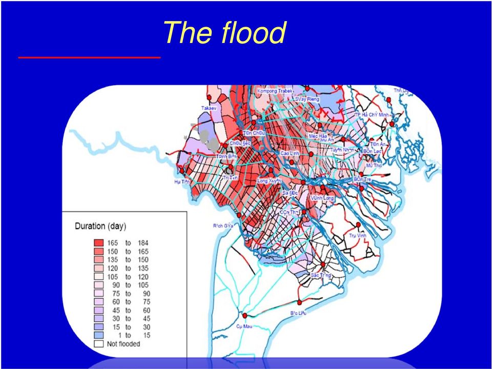
8 High Flood in the MD will happen when 3 major factors come at the same time: 10% High flow dischrage from upstream 60% Heavy rainfall continuously 30% High tidal flow from the East Sea

9 WATER ALARM LEVELS (meter) IN THE MEKONG RIVER Level I Level II Level III Gauging Station Tien River Tan Chau My Thuan Hau River Chau Doc CanTho (Potential flood) (Dangerous flood) (Very dangerous flood)

10 Em có số liệu chứng minh lũ thay đổi hoặc thiệt hại do climate change đưa vào nhé, mấy cái slide này không thấy có liên quan gì đến climate change Annual Series - Flood Levels Tan Chau- Tien River (Mekong) Year High Flood: H 4.50 m In Tan Chau Med. Flood: H = m Low Flood: H 4.00 m 1926 Flood Level - cm

11 MD Flood damages The severity degree of the floods is increasing The flood in 2000: 35 times bigger than that of flood year 1950; 1,17 times compared to flood year 1996 (N.D.Tuan, 2000). the most damaging floods in 70 years. 760,000 houses are submerged; 67,000 families have been evacuated; 319 people have been died, of which 236 were children. The net loss has been evaluated at 2,670 billion VN Dong.

12 How to live with flood??

13 Local government flood mitigation measures 1. Structural measures: Full-dike protected system: Height designed based on the measured and calculated flood peaks. Ensures the safety for the people's daily activities and cultivation in the whole duration August-dike protected system: The top height of the dyke is designed to ensures the second crop have been harvested before flood water exceed the field

14 Local government flood mitigation measures 2/ Non-structural measures Shifting of cropping calendar the Summer- Autumn crop can be finished before the early flood. Changing the cropping pattern and animal husbandry that suitable for the flood condition. Improving the post-harvest technology. Planting more trees along the roads and dikes to reduce the flood damages. Excavating people in the potential erosion areas or in the depth flood areas into the flood protected residential areas. Distributing Life vest Supporting health care boats

15 Flow measured data Mekong Secretariat Satellite Internet Regional Hydro-meteorology Centers General department of hydro-meteorology Committtee for flood and storm preparedness Provincial Goverments and Flood prevention Committees TV/ Radio/ Newspapers Main information lines Others information lines Information lines in emergaency cases LOCAL PEOPLE

16 Local people living with flood Moving Animal Teaching chidrend to swim Rising house Control flood by sand bags Taking childen to school

17 Local people living with flood Fishing in flood zone Raising fish in the paddy field Catching yellow snail Planting aquatic vegetable Raising ill in the net

18 Farmer adaptation to flood (Logistic analysis, Exp(B) Insert one vegetable cropbetween 2 short rice crops Grow aquatic plants Variable Food Fishing tools Boat and lifeves Aquaculture Fishing Trading on boat Grow short rice crops Dyke system No dyke Semi-dyke full dyke income group Poor Rich Medium Food preparation is considered more on semi-dyke and no-dyke areas and the rich and medium are more able to prepare food compare to the poor who are strongly depended on the natural fish sources (fishing tools, fishing). Farmers in the semi-dyke and no-dyke area have to prepare boat and live vest for transportation and fishing during the flood season. And the medium and poor use boat more since they need it for their main source of income: fishing and trading on boat. Agriculture adaptation: Farmers in no-dyke and semi-dyke use short rice varieties to ensure their harvesting before flood season and insert one vegetation crop between 2 short rice crops. During the flood season, poor farmers also grow aqua-plant for more income. Aquaculture: Since aquaculture requires high investment and maintaining costs, Rich and the medium farmers are easier to do (4 and 3 times compare to the poor)

19 Farmer adaptation to flood (Logistic analysis, Exp(B) Variable Pilehouse Raise basement move tree Embankment Move animal Children protection Semi-dyke No dyke Semi-dyke full dyke income group Poor medium rich Since semi-dyke area is still inundated during flood season, pile house is the most selection and it seem more interested by the rich and the poor farmers. The medium farmers prefer more on raising house s basement. Actually the poor pile house is made by very cheap local wood while the rich build strong concrete pile house. Rise embankment requires big investment, only the rich can afford. The medium and poor want to move their animal to higher place while the rich have stable house and cage do not need to move their animal. Children in the no-dyke areas are move to the safe place while people in the semi-dyke area take care of their children themselves in the same place. The poor more care about their children because of their worse living condition. Considering the disadvantages of full-dyke, farmers in full-dyke areas prefer semi-dyke more than the people in other areas. And all income groups are prefer the semi-dyke, especially the medium and rich.

20 Farmer s perception to Government measures Measures Advantages Disadvantages Recommendations/supported needs Full-dyke Semi-dyke Protect crops, assets whole year round Good condition for animal husbandry, Better transportation infrastructure, Generate more jobs Safe for children, women Prolong the cropping calendar (ensure the second rice crop and start the fist crop earlier). Increase the soil fertility, Remove pollution, Increase fish sources, reduce the wave so that farmer can grow fish Less affect to the upstream and downstream. Reduce the soil fertility, Reduce fish source, Increase crop disease, Water pollution, High construction cost, Influences to the water regime of the upstream and downstream areas bank erosion High maintaining cost Living condition is still difficult (drinking water, house, transportation). Apply to small areas or residential areas. Financial support, technical training (The rich & medium) More jobs, boats and fishing tools (the poor) Apply widely to ensure 2 rice crops per year Better road, electricity, drinking water supply Better crop and animal varieties Strengthening the dyke system, technology transfer and better crop varieties (the rich) Job training for women, capital for animal husbandry (the medium) Job training, boat and fishing tools More job, fishing tools (the poor) Most of farmer agree on the government s non-structure measures for flood management

21 Conclusions Government In general, local government have been doing a lot to support the people in the flooded area. Recommendations: Better flood forecasting Need to have more financial and technical support (job training) Invest more on August-dike protected system to protect agriculture and full-dike protection system only for residential areas Focus more on the environment and the recreation in the resettlement areas Aware of the affects to the downstream area: pollution, water level and bank erosion. Prepare to deal with climate change Operate free or low cost kindergarten for the poor Better boats for taking children to school
22 Conclusions Farmers The rich, the fairly rich and the average farmers are better prepared to deal with flood than the poor farmers. Rich farmer more aware of food, the average and poor farmers prepare more on fishing tools and boats. Farmers can take the advantages of flood: fishing, refresh the land, raising suitable crops and aquaculture. Most of farmer agree on the government strategy on flood management Recommendations: Aware of environmental problems at their land and downstream areas Reduce inorganic fertilizer use in the full-dike protection area Take care of the children or send them to the kindergarten Strengthening houses (pile or basement) and boats Using clean water (rain water or treated flood water)
23 Flower village in Dong Thap in a flood season Thank you very much for your attention
How To Understand And Understand The Flood Risk Of Hoang Long River In Phuon Vietnam
 FLOOD HAZARD AND RISK ASSESSMENT OF HOANG LONG RIVER BASIN, VIETNAM VU Thanh Tu 1, Tawatchai TINGSANCHALI 2 1 Water Resources University, Assistant Professor, 175 Tay Son Street, Dong Da District, Hanoi,
Progress of Water Environmental Governance/Management and Future Challenges in Vietnam
 Progress of Water Environmental Governance/Management and Future Challenges in Vietnam The Second International Workshop and the Sixth Annual Meeting for Water Environmental Partnership in Asia (WEPA)
Training Materials for Scaling-up Climate Change Adaptation and Modified Procedures
 Coastal Adaptation and Resilience Planning Component Training Materials for Scaling-up Climate Change Adaptation and Modified Procedures December 2013 ii Training Materials for Scaling-up Climate Change
Chapter 4. Current Adaptation to Floods
 Chapter 4. Current Adaptation to Floods This chapter studies current flood adaptation strategies in land use planning and housing practices in the studied area. This is obtained through literature review
Flooding Fast Facts. flooding), seismic events (tsunami) or large landslides (sometime also called tsunami).
, seismic events (tsunami) or large landslides (sometime also called tsunami).") Flooding Fast Facts What is a flood? Flooding is the unusual presence of water on land to a depth which affects normal activities. Flooding can arise from: Overflowing rivers (river flooding), Heavy rainfall
Flooding Fast Facts What is a flood? Flooding is the unusual presence of water on land to a depth which affects normal activities. Flooding can arise from: Overflowing rivers (river flooding), Heavy rainfall
Management of Water and Fisheries Resources to Improve Community Livelihoods in Battambang
 GEF Small Grants Programme Community-Based Adaptation in Small Island Developing States - SIDS CBA Management of Water and Fisheries Resources to Improve Community Livelihoods in Battambang Project No:
REVOLVING LOAN PROGRAMME
 REVOLVING LOAN PROGRAMME Annual Report 2013 Christina Noble Children s Foundation - Vietnam PROgrAMME DESCRIPTION Established: 1997 Reporting Period: January to December 2013 Location: Target Group: Local
Best Practice of Flood Hazard Map in Japan
 Best Practice of Flood Hazard Map in Japan 1. Hazard map in Japan There are about 1,500 municipalities in Japan, which need to prepare flood hazard map. 510 municipalities have already made and disclosed
Climate Change Impacts on Agriculture in Vietnam
 Strengthening Capacities to Enhance Coordinated and Integrated Disaster Risk Reduction Actions and Adaptation to Climate Change in Agriculture in the Northern Mountain Regions of Viet Nam Climate Change
LIST OF HOSPITALS/FAMILY MEDICAL CENTRES Last updated: October 2014 ORGANISATION ADDRESS REMARKS
 LIST OF HOSPITALS/FAMILY MEDICAL CENTRES Last updated: October 2014 Please note that this list is provided for the information of Australian travellers and those needing medical assistance in Vietnam.
SJV1435 INFOSHEET EXPERIENCING CULTURE WITH ETHNIC PEOPLE AT BUOC-VILLAGE.
 SJV1435 INFOSHEET EXPERIENCING CULTURE WITH ETHNIC PEOPLE AT BUOC-VILLAGE. CODE NUMBER AND TIME SJV1435 04/11/2014-15/11/2014 WELCOME WORDS FROM CAMP LEADER Dear volunteers, Firstly, it is a great honor
Chapter IV. THE WATER QUALITY MANAGEMENT IN THREE RIVER BASINS
 Chapter IV. THE WATER QUALITY MANAGEMENT IN THREE RIVER BASINS 4.1. RELEVANT POLICIES AND REGU- LATIONS Protection of river basin environment is one of the basic contents of the Plan on water resource
SCHOLARSHIP PROJECT PROPOSAL
 SCHOLARSHIP PROJECT PROPOSAL Global Giving Challenge 2010 (A) ABOUT SAIGON CHILDREN S CHARITY Founded in 1992, SCC is a UK registered charity working exclusively in Vietnam. We received our full Vietnamese
RENEWABLE ENERGY DEVELOPMENT AND BUSINESS OPPORTUNITIES IN VIETNAM
 BITEC, Bangkok Friday 3 rd June 2011 RENEWABLE ENERGY DEVELOPMENT AND BUSINESS OPPORTUNITIES IN VIETNAM M.Eng. Nguyen Dang Anh Thi Deputy Director, Energy Conservation Center of Ho Chi Minh City, Vietnam
BANGKOK FLOOD PROTECTION SYSTEM Bangkok Metropolitan Administration (BMA)
") BANGKOK FLOOD PROTECTION SYSTEM Bangkok Metropolitan Administration (BMA) Catchment area of Chao Phraya River is 160,000 sq.km. or about 1/3 of the country The Chao Phraya River flows passing through Bangkok
BANGKOK FLOOD PROTECTION SYSTEM Bangkok Metropolitan Administration (BMA) Catchment area of Chao Phraya River is 160,000 sq.km. or about 1/3 of the country The Chao Phraya River flows passing through Bangkok
CLIMATE CHANGE IN VIETNAM AND RESPONSE Tran Thuc, Tran Hong Thai Nguyen Van Thang, Hoang Duc Cuong, Vietnam Institute of Hydro-Meteorology and
 CLIMATE CHANGE IN VIETNAM AND RESPONSE Tran Thuc, Tran Hong Thai Nguyen Van Thang, Hoang Duc Cuong, Vietnam Institute of Hydro-Meteorology and Environment Contents Climate change in Vietnam Vietnam NTP
Application of Space Technology for Disaster monitoring and assessment current state in Vietnam
 Application of Space Technology for Disaster monitoring and assessment current state in Vietnam Lai Anh Khoi SPACE TECHNOLOGY INSTITUTE 8th GEOSS Asian Pacific Symposium Beijing, Sep. 09-11, 2015 Types
Track-Risk-Impact-Policy (TRIP) Modeling for the Agricultural Sector
 Modeling for the Agricultural Sector") Track-Risk-Impact-Policy (TRIP) Modeling for the Agricultural Sector Glenn S. Banaguas Environmental and Climate Change Research Institute De La Salle Araneta University Manila Observatory Ateneo De Manila
Track-Risk-Impact-Policy (TRIP) Modeling for the Agricultural Sector Glenn S. Banaguas Environmental and Climate Change Research Institute De La Salle Araneta University Manila Observatory Ateneo De Manila
FLOOD PROTECTION AND ECOSYSTEM SERVICES IN THE CHEHALIS RIVER BASIN. May 2010. Prepared by. for the. 2010 by Earth Economics
 FLOOD PROTECTION AND ECOSYSTEM SERVICES IN THE CHEHALIS RIVER BASIN May 2010 Prepared by for the Execubve Summary The Chehalis Basin experienced catastrophic flooding in 2007 and 2009. In response, the
Agricultural Production and Research in Heilongjiang Province, China. Jiang Enchen. Professor, Department of Agricultural Engineering, Northeast
 1 Agricultural Production and Research in Heilongjiang Province, China Jiang Enchen Professor, Department of Agricultural Engineering, Northeast Agricultural University, Harbin, China. Post code: 150030
FLOOD RISK RECENT TRENDS AND POLICY RESPONSES
 FLOOD RISK RECENT TRENDS AND POLICY RESPONSES DEVELOPING WESTMINSTER S LOCAL PLAN Booklet No. 2 LDF Consultation - CMP Revision November 2013 INTRODUCTION CLLR ROBERT DAVIS Westminster is at risk of flooding
The IPCC Special Report on Managing the Risks of Extreme Events and Disasters to Advance Climate Change Adaptation
 The IPCC Special Report on Managing the Risks of Extreme Events and Disasters to Advance Climate Change Adaptation A changing climate leads to changes in extreme weather and climate events 2 How do changes
Damage Assessment in a large River Basin The Mekong Experience. Phan Nguyen& Anthony Green Mekong River Commission
 Damage Assessment in a large River Basin The Mekong Experience Phan Nguyen& Anthony Green Mekong River Commission Contents 1. Features and vulnerabilities 2. Influence of Changing Climate 3. Damage Assessment
 Disaster Prevention Measures in Global-Local Context 4 th World Water Forum Dr. Yoshihiko Yamashita CTI Engineering Co., Ltd Association of Japanese Consulting Engineers Outline of Presentation Up-to to-date
Flood Facts 2F.1. Flood Facts
 Flood Facts 2F.1 Engage Flood Facts To introduce students to the causes and effects of flooding in Western Australia. Flooding occurs in the Australian environment as part of the natural water or hydrologic
Water Security in Iraq
 Water Security in Iraq Dr. Hassan Janabi Ambassador Permanent Representative of Iraq To the UN Food and Agriculture Organization (FAO) And other Rome-based UN Agencies (WFP & IFAD) Introduction: Iraq is
BRIEFING NOTE. Assessment of Innovative Approaches to Flood Risk Management and Financing in Agriculture: The Thailand Case Study 1
 Public Disclosure Authorized Public Disclosure Authorized BRIEFING NOTE Assessment of Innovative Approaches to Flood Risk Management and Financing in Agriculture: The Thailand Case Study 1 Public Disclosure
CLIMATE CHANGE AND ITS IMPACT ON AGRICULTURE IN VIETNAM
 CLIMATE CHANGE AND ITS IMPACT ON AGRICULTURE IN VIETNAM Tran Duc Vien Hanoi University of Agriculture INTRODUCTION Climate change, which includes increases in temperature, changes in rainfall patterns,
Flood Emergency Response Planning: How to Protect Your Business from a Natural Disaster RIC005
 Flood Emergency Response Planning: How to Protect Your Business from a Natural Disaster RIC005 Speakers: Tom Chan, CEO, Global Risk Miyamoto Greg Bates, Principal, Global Risk Consultants Learning Objectives
List of Medical Facilities/Practitioners in Ho Chi Minh City
 List of Medical Facilities/Practitioners in Ho Chi Minh City Updated: Jan 2015 Prepared by British Consulate-General in Ho Chi Minh City www.gov.uk The following list of medical facilities/practitioners
Integration of GIS and Multivariate Statistical Analysis in Master Plan Study on Integrated Agricultural Development in Lao PDR
 Integration of GIS and Multivariate Statistical Analysis in Master Plan Study on Integrated Agricultural Development in Lao PDR GIS Makoto ISHIZUKA, Tetsunari GEJO, Shigeya OOTSUKA and Yukiyasu SUMI GIS
INDONESIA - LAW ON WATER RESOURCES,
 Environment and Development Journal Law LEAD INDONESIA - LAW ON WATER RESOURCES, 2004 VOLUME 2/1 LEAD Journal (Law, Environment and Development Journal) is a peer-reviewed academic publication based in
Making Irrigation Management Pro-Poor: Lessons from China and Vietnam
 Making Irrigation Management Pro-Poor: Lessons from China and Vietnam Introduction: Eric Biltonen *, Doan Doan Tuan **, Jinxia Wang *** In recent years, attention has been increasingly focused on the role
Building Capacity to Make Transport Work for Women and Men in Vietnam
 EAST ASIA AND PACIFIC REGION Social Development Notes INNOVATIONS, LESSONS, AND BEST PRACTICE Building Capacity to Make Transport Work for Women and Men in Vietnam Gender and Transport Challenges Women
A preliminary analysis of flood and storm disaster data in Viet Nam
 A preliminary analysis of flood and storm disaster data in Viet Nam Oanh Luong Nhu, Nguyen Thi Thu Thuy, Ian Wilderspin and Miguel Coulier March 2011 1 A preliminary analysis of flood and storm disaster
TURKEY ANATOLIA WATERSHED REHABILITATION PROJECT Sedat Kadioglu Ministry of Environment Abdulmecit Yesil Ministry of Agriculture and Rural Affairs
 TURKEY ANATOLIA WATERSHED REHABILITATION PROJECT Sedat Kadioglu Ministry of Environment Abdulmecit Yesil Ministry of Agriculture and Rural Affairs PROJECT TITLE : Anatolia Watershed Rehabilitation Project
ARIMNet 2 Call 2014-15
 Coordination of the Agricultural Research In the Mediterranean Area Call i text ARIMNet 2 Call 2014-15 SUBMISSION Pre-proposal by December 1 st, 2014 Full Proposal by May 11 th 2015 on http://arimnet-call.eu/
DESIGN OF STORM WATER DETENTION POND
 Yunnan Chuxiong Urban Environment Improvement Project (RRP PRC 45507) DESIGN OF STORM WATER DETENTION POND A. Background 1. Chuxiong Yi Autonomous Prefecture (Chuxiong prefecture) is located at about 160
Burnt River Black River and Gull River Flood Contingency Plan
 Burnt River Black River and Gull River Flood Contingency Plan Objective: The objective of this plan is to preplan and prepare for flooding events in the Burnt River, Black River and Gull River area of
4.14 Netherlands. Interactive flood risk map of a part of the province of Gelderland in the Netherlands. Atlas of Flood Maps
 4.14 Netherlands The Netherlands is flood prone for about 60% of its surface. 95 so-called dike-rings protect the polders from being flooded from the North Sea, rivers or lakes. The protection level has
Madagascar: Makira REDD+
 project focus Madagascar: Makira REDD+ Madagascar is considered to be one of the top five biodiversity hotspots in the world due to more than 75% of all animal and plant species being endemic while less
Mud in the Water. www.agclassroom.org/ok. Oklahoma Academic Standards. Objective. Background. Resources Needed. Activities
 Mud in the Water Objective Students will learn about soil erosion and water pollution by building a demonstration model from pop bottles and observing the movement of pollutants from soil into water. Background
Experience in Wetlands restoration and conservation concerning natural water retention measures. Ministry of Environment and Water, Bulgaria
 Experience in Wetlands restoration and conservation concerning natural water retention measures Ministry of Environment and Water, Bulgaria Water management in Bulgaria - Water management in Bulgaria national
4 Research Methodology
 4 Research Methodology 4.1 Introduction This chapter presents the conceptual framework used for the study. The conceptual model gives a clear picture of the structure of the study and shows how the theory
REPORT OF STUDYTOUR TO HOA BINH PROVINCE. (29 August 2011)
") REPORT OF STUDYTOUR TO HOA BINH PROVINCE (29 August 2011) August 2011 Table of Contents I. PURPOSE AND SCHEDULE OF THE STUDYTOUR... 3 1. Purpose of the studytour... 3 2. Schedule... 3 3. Participants...
REPORT OF STUDYTOUR TO HOA BINH PROVINCE (29 August 2011) August 2011 Table of Contents I. PURPOSE AND SCHEDULE OF THE STUDYTOUR... 3 1. Purpose of the studytour... 3 2. Schedule... 3 3. Participants...
Doing Business, Small & Medium Enterprise Support and Information Access
 Doing Business, Small & Medium Enterprise Support and Information Access Vietnam, a nation of 92 million people, aspires to be more fully integrated into the global economy and community and an industrialized
ABORTION IN PRESENT DAY VIETNAM
 ABORTION IN PRESENT DAY VIETNAM Nguyen Thanh Binh Ph.d student, Free University of Berlin, Germany E-mail: binh1980gdct@yahoo.com.vn Abstract In recent years, the abortion rate in Vietnam has been likely
APPLICATION PROCESS FOR LAND DISTURBING PERMIT
 PREFACE: APPLICATION PROCESS FOR LAND DISTURBING PERMIT The property owner, developer and designated planners and engineers shall review the general development plans and detailed plans of the Local Issuing
Itinerary for University of Montana Vietnam Study Abroad Program. 28 December 2014 to 20 January 2015
 Itinerary for University of Montana Vietnam Study Abroad Program 28 December 2014 to 20 January 2015 Sunday 28 December 9:50 am 11:40 pm Monday 29 December 8:45 am 9:45 am 10:00 am 1:30 pm 3:30 pm 5:30
Martine Jak 1 and Matthijs Kok 2
 A DATABASE OF HISTORICAL FLOOD EVENTS IN THE NETHERLANDS Martine Jak 1 and Matthijs Kok 2 1 Department of Transport, Public works and Water Management Road and Hydraulic Engineering Division P.O. Box 5044
Water Quality and Water Usage Surveys
 Appendix 1 Water Quality and Water Usage Surveys This appendix contains copies of the Water Quality Survey and the Lake Usage Survey that we used to complete the watershedbased community assessments. We
October 5, 2013. SITUATION REPORT Muslim Aid-UK, Bangladesh Field Office
 Hazard Type : Water Logged (Update # 01) Location : Tala, Satkhira District, Bangladesh Reporting Date : October 05,. Time: 07.30 PM BST Prepared by : Shofiul Alam, Emergency Response Coordinator, MABFO
A STUDY ON OWN FUND REVENUE GENERATION THROUGH COMMON PROPERTY RESOURCE MANAGEMENT IN MADANMOHANPUR GRAM PANCHAYAT, WEST BENGAL
 A STUDY ON OWN FUND REVENUE GENERATION THROUGH COMMON PROPERTY RESOURCE MANAGEMENT IN MADANMOHANPUR GRAM PANCHAYAT, WEST BENGAL INTRODUCTION:- Self-Governing Institutions are an integral part of the Indian
Discussion about the practicability of implementing flood risk. management and urban flood insurance in China. Longhua Gao, Xiaoqing Zhou
 Discussion about the practicability of implementing flood risk management and urban flood insurance in China Longhua Gao, Xiaoqing Zhou Abstract: This paper explains the flood risk management at first,
Sustainable Livelihood Opportunities and Resource Management in Coastline Communes Facing Special Difficulties
 Ministry of Planning and Investment Partnership to Assist the Poorest Communes (PAC) Sustainable Livelihood Opportunities and Resource Management in Coastline Communes Facing Special Difficulties Cecilia
Ponds- Planning, Design, Construction
 United States Department of Agriculture Soil Conservation Service Agriculture Handbook Number 590 Ponds- Planning, Design, Construction This handbook describes the requirements for building a pond. It
Development of agricultural insurance in Russia
 Development of agricultural insurance in Russia International Conference Managing risks and crises in agricultural insurance 15th, 16th and 17th of March 2010 Liudmila Kosholkina Director of the Department
How To Manage A Flood In Mozambique
 Flood Risk Management in Mozambique and Sub-regional Trans-boundary Issues UNFCCC regional expert meeting on loss and damage in Addis Ababa, Ethiopia from 13 to 15 June 2012 Ron Cadribo, UNISDR DRR Advisor,
Planning for sea level rise. Assessing development in areas prone to tidal inundation from sea level rise in the Port Phillip and Westernport Region
 Planning for sea level rise Assessing development in areas prone to tidal inundation from sea level rise in the Port Phillip and Westernport Region Table of contents Introduction 1 New flood levels for
ELECTRICITY CORPORATION OF VIETNAM (EVN) Inception Report INDEPENDENT RESETTLEMENT MONITORING
 Inception Report INDEPENDENT RESETTLEMENT MONITORING") ELECTRICITY CORPORATION OF VIETNAM (EVN) TRUNG SON HYDROPOWER PROJECT MANAGEMENT UNIT =================================================== Inception Report INDEPENDENT RESETTLEMENT MONITORING Construction
ELECTRICITY CORPORATION OF VIETNAM (EVN) TRUNG SON HYDROPOWER PROJECT MANAGEMENT UNIT =================================================== Inception Report INDEPENDENT RESETTLEMENT MONITORING Construction
Waterway Technote Drains
 Waterway Technote Drains Contents Benefits of good drain practice 1 Are your drains healthy? 2 The Sustainable Dairying Water Accord 3 Planning drain maintenance 3 Fencing and clearing 3 Bank shaping (battering)
QUESTIONS AND ANSWERS WATERS OF THE U.S. PROPOSAL
 QUESTIONS AND ANSWERS WATERS OF THE U.S. PROPOSAL Key Background Congress enacted the modern Clean Water Act in 1972 to address pollution entering the nation s waters to complement statutes such as the
INSTALLATION OF AN AUTOMATED EARLY WARNING SYSTEM FOR ANNOTTO BAY
 TERMS OF REFERENCE INSTALLATION OF AN AUTOMATED EARLY WARNING SYSTEM FOR ANNOTTO BAY A Community Disaster Risk Reduction Project funded through the Building Disaster Resilient Communities Project (ODPEM)
Flood Risk Management
 Flood Risk Management Value of Flood Risk Management Every year floods sweep through communities across the United States taking lives, destroying property, shutting down businesses, harming the environment
Flood Risk Management
 Flood Risk Management Value of Flood Risk Management Value to Individuals and Communities Every year floods sweep through communities across the United States taking lives, destroying property, shutting
Supporting women entrepreneurs
 Market Access for the Poor The NAPA programme in Quang Binh Supporting women entrepreneurs Vietnam Rural banks connected with Women entrepreneurs Despite Vietnam s impressive economic growth, there is
How To Plan A Buffer Zone
 Backyard Buffers Protecting Habitat and Water Quality What is a buffer? A buffer (also called a riparian buffer area or zone) is the strip of natural vegetation along the bank of a stream, lake or other
Overview and highlights
 This country profile was compiled by the OECD Secretariat and reflects information available as of March 2015. Further information and analysis can be found in the publication: OECD (2015) Water Resources
Solar PV panels fitted to roofs. Solar PV panels produce electricity from energy provided by sunlight. 3.5 MWh per system
 Solar PV panels fitted to roofs Yearly cost of production Cost per kwh 12.5p Solar PV panels produce electricity from energy provided by sunlight. 3.5 MWh per system 430 per system Solar energy can be
5.0 OVERVIEW OF FLOOD DAMAGE REDUCTION MEASURES
 5.0 OVERVIEW OF FLOOD DAMAGE REDUCTION MEASURES Flood damage reduction consists of two basic techniques structural and non-structural. Structural methods modify the flood and take the flood away from people
Chapter 18 Introduction to. A f r i c a
 Chapter 18 Introduction to A f r i c a Ch. 18:1 Landforms & Resources 1. Africa s shape & landforms are the result of its location in the southern part of the ancient supercontinent of. Pangaea Over thousands
Rural Flooding: The Potential Role of Forestry
 Rural Flooding: The Potential Role of Forestry Nadeem Shah, Tom Nisbet, & Huw Thomas Centre for Forestry and Climate Change Structure Background Woodland and Flood Alleviation The Theory. Studies on Woodland
FOUR RIVERS RESTORATION PROJECT
 MLTM Republic of Korea Making Every Drop Count International Workshop on Integrated Urban Water Management WATER & GREEN GROWTH FOUR RIVERS RESTORATION PROJECT Office of National River Restoration, Korea
Floods are too much water on normally dry land. Rivers can flood after heavy rain has fallen over a long period of time. River flooding can last
 Floods are too much water on normally dry land. Rivers can flood after heavy rain has fallen over a long period of time. River flooding can last weeks or longer. River floods usually occur slowly enough
Standard Operating Procedures for Flood Preparation and Response
 Standard Operating Procedures for Flood Preparation and Response General Discussion Hurricanes, tropical storms and intense thunderstorms support a conclusion that more severe flooding conditions than
National Disaster Management Institute
 National Disaster Management Institute CONTENTS one Cause of Urban Flood Disaster two Urban Flood Damage Case three Disaster Prevention Measures for Future Urban Flood four NDMI s Measures & Strategy for
Royal University o f of A gricultur gricultur Agricultur Graduate School Low carbon activities and re Low carbon activities and r sear
 Royal University of Agriculture Graduate School Low carbon activities and research by Royal University of Agriculture Present by : Mr. KIM Soben 29 th May, 2012 Contents 1. About RUA 2. Research and development
Second Quarterly Report for the period January March 2011
 Second Quarterly Report for the period January March 2011 Project: Bidding package: Technical assistance for enhancement capacity of HFIC and project owners financed under AFD s credit line (HCE Project)
Global Flood Alert System (GFAS)
") An Introduction of Global Flood Alert System (GFAS) Kazuo UMEDA Director of 2 nd Research Department, Infrastructure Development Institute-JAPAN Target: Reduction of Human Loss World s s natural disaster
An Introduction of Global Flood Alert System (GFAS) Kazuo UMEDA Director of 2 nd Research Department, Infrastructure Development Institute-JAPAN Target: Reduction of Human Loss World s s natural disaster
Environmental Engineering, University of Seoul, Jennong-dong, Dongdaemun-gu, Seoul, Korea.
 WATER QUALITY MANAGEMENT FOR ECOLOGICAL RESTORATION IN ANYANG STREAM Yu, M.J., Cho, Y.M. 2, Lee, S.K. 3 Environmental Engineering, University of Seoul, Jennong-dong, Dongdaemun-gu, Seoul, Korea. 2 Department
Status and National Priorities of Soil Resources in Sri Lanka
 Status and National Priorities of Soil Resources in Sri Lanka R S Dharmakeerthi President, Soil Science Society of Sri Lanka and W D Wicramasinghe Director, NRMC &Country Focal Point-FAO 1. Introduction:
COMMUNITY-BASED DISASTER RISK MANAGEMENT IN
 Partnerships for Disaster Reduction-South East Asia Phase 4 MONITORING AND REPORTING PROGRESS ON COMMUNITY-BASED DISASTER RISK MANAGEMENT IN April 2008 VIET NAM crvietnam.indd 1 11/23/08 4:50:58 PM crvietnam.indd
Flood Mitigation and Management in Bangkok Metropolitan Area
 กร งเทพมหานคร Flood Mitigation and Management in Bangkok Metropolitan Area Present By Mr. Kriangkrai Phamornpol Department of Drainage and Sewerage Bangkok Metropolitan Administration 1 Flood Mitigation
Long Term Challenges for Tidal Estuaries
 A view from a former tidal river manager expert with experience from 6 decades living at, with and from the Tidal River Elbe chairman of the European Interreg Project TIDE (Tidal River Development) Land
WATER HARVESTING AND AQUACULTURE FOR RURAL DEVELOPMENT INTRODUCTION TO AQUACULTURE
 WATER HARVESTING AND AQUACULTURE FOR RURAL DEVELOPMENT INTRODUCTION TO AQUACULTURE 2 INTERNATIONAL CENTER FOR AQUACULTURE AND AQUATIC ENVIRONMENTS AUBURN UNIVERSITY 3 INTRODUCTION More than one-fourth
MARKET STRUCTURE AND MARKETING CHANNEL ANALYSIS: THE CASE OF SWINE IN THE MEKONG DELTA VIETNAM
 SCHOOL OF ECONOMIC AND BUSINESS ADMINISTRATION CANTHO UNIVERSITY Research Paper (NPT program B3) MARKET STRUCTURE AND MARKETING CHANNEL ANALYSIS: THE CASE OF SWINE IN THE MEKONG DELTA VIETNAM Participants:
Index Insurance in India
 Index Insurance in India Kolli N Rao, PhD Aon Benfield, India Indian Agriculture & Risks What s Index Insurance? Why Index Insurance? The Outline Architecture of Indian Crop Insurance Coverage: The Numbers
SPACE TECHNOLOGY IN VIETNAM
 SPACE TECHNOLOGY IN VIETNAM Tran Manh Tuan Coordination Center for Space Technology Applications (CCSTA) Vietnamese Academy of Science and Technology (VAST) Contents A. Review of some Space Technology
Markets for Ecosystem Services on Agricultural Lands: Experience and Outlook in the United States
 Markets for Ecosystem Services on Agricultural Lands: Experience and Outlook in the United States Frank Casey Conservation Economics and Finance Program Defenders of Wildlife Presented at the Biodiversity
SECTION 3.2 CLIMATE AND PRECIPITATION
 SECTION 3.2 CLIMATE AND PRECIPITATION Ulster County Climate Data A preliminary analysis of the Preserve s weather data shows that the average temperature has risen about two degrees over the past 114 years.
WELCOMES ALL THE ATTENDEES WATER UTILISATION, MEASUREMENT AND METHODOLOGIES
 SUTRON india WELCOMES ALL THE ATTENDEES WATER UTILISATION, MEASUREMENT AND ABOUT SUTRON USA Strong Corporation was founded in 1975 Sutron Operates in : Hydrological Meteorological Oceanic Aviation Real-Time
COLLEGE OF INFORMATION & COMMUNICATION TECHNOLOGY (CICT) www.cit.ctu.edu.vn
 www.cit.ctu.edu.vn") COLLEGE OF INFORMATION & COMMUNICATION TECHNOLOGY (CICT) www.cit.ctu.edu.vn Outline Can Tho University College of ICT (CICT) Mission Organization Fields of Study Facilities Relation & Cooperation Research
COLLEGE OF INFORMATION & COMMUNICATION TECHNOLOGY (CICT) www.cit.ctu.edu.vn Outline Can Tho University College of ICT (CICT) Mission Organization Fields of Study Facilities Relation & Cooperation Research
Swannanoa River Flood Risk Management Study
 Swannanoa River Flood Risk Management Study Measures Evaluated to Reduce Future Flood Damages City of Asheville U.S. Army Corps of Engineers Flooding History Part of the 132 square mile Swannanoa River
Correlation Analysis of Factors Influencing Changes in Land Use in the Lower Songkhram River Basin, the Northeast of Thailand
 Correlation Analysis of Factors Influencing Changes in Land Use in the Lower Songkhram River Basin, the Northeast of Thailand Rasamee SUWANWERAKAMTORN and Chat CHANTHALUECHA Geo-informatics Centre for
COMPREHENSIVE DEVELOPMENT OF THE BRANTAS RIVER BASIN THE REPUBLIC OF INDONESIA
 COMPREHENSIVE DEVELOPMENT OF THE BRANTAS RIVER BASIN THE REPUBLIC OF INDONESIA By Achmad RUSFANDI Usman, Ir, M.Eng Former President Director of Jasa Tirta I Public Corporation Lecturer on Faculty of Engineering,
VISUAL 6.1 GREAT BRITAIN S AMERICAN COLONIES
 SPECIALIZATION AND TRADE IN THE THIRTEEN COLONIES LESSON 6 VISUAL 6.1 GREAT BRITAIN S AMERICAN COLONIES GREAT BRITAIN S COLONIES All colonies are rich in natural resources but short on labor. PRODUCTIVE
Post-Flood Assessment
 Page 1 of 7 Post-Flood Assessment CHAPTER 4 AGENCY COORDINATION Agency coordination is an essential element for the operation of the flood management systems in the Central Valley. Due to the nature of
SHANGHAI: TRENDS TOWARDS SPECIALISED AND CAPITAL-INTENSIVE URBAN AGRICULTURE
 SHANGHAI: TRENDS TOWARDS SPECIALISED AND CAPITAL-INTENSIVE URBAN AGRICULTURE Cai Yi-Zhong and Zhang Zhangen 1. Introduction The Chinese are famous for their highly intensive urban cropping systems and
INTRODUCTION OF POWER TRADING VIETNAM CHINA BY 220kV LINES HANOI 04/2014
 INTRODUCTION OF POWER TRADING VIETNAM CHINA BY 220kV LINES HANOI 04/2014 1 Contents: 1 Overview 2 Electricity import from China by 220kV Overhead line 3 Trading and operating issues 2 Overview of Vietnam
Tool 2.3.1: General information on the causes of rainfall-induced landslides
 Impacts of Climate Change on Urban Infrastructure & the Built Environment A Toolbox Tool 2.3.1: General information on the causes of rainfall-induced landslides Author G. Dellow Affiliation GNS Science,