Bruce Aquila, Intergraph Corporation. Session 4.3.1, Tuesday April 13th
|
|
|
- Gervais Crawford
- 7 years ago
- Views:
Transcription
1 Kansas DOT's New Implementation of Active Straight Line Diagrams (SLD) within their GIS web portal Bruce Aquila, Intergraph Corporation Session 4.3.1, Tuesday April 13th
2 Introduction Overview of existing KGATE web portal Business drivers to add SLD s SLD architecture SLD functionality Summary Page 2
3 KGATE Mission Central point of discovery for KDOT and partners Streamlines data access and research Access to data is expanded to new users Consistent access mechanism to data throughout the agency Allows viewing of multiple data sets simultaneously Page 3
4 KGATE Page 4
5 KGATE Scope KGATE combines layers of information about a location to give users a better understanding of the location KGATE Users Internal Have permission to see everything External Can only see what we ve given them permission to see Page 5
6 KGATE External Users Kansas Highway Patrol Used for accident analysis Can see where KHP Troop areas are located, the scanned in accident reports, etc. Kansas Trucking Connection Used to route trucks through Kansas Can obtain useful information about bridges, vertical clearances, construction locations, etc. Page 6
7 KGATE - Mapping Functional Class Page 7
8 KGATE - Integration Map bridges, select bridge, view video log Page 8
9 SLD - Definition Is a view of a roadway as lines Displays features along the road linearly Depicts road characteristics linearly Can consist of one or multiple pages per alignment section There are usually 3 basic components to an SLD: Plan View Schematic Attribute View Page 9
10 SLD Business Drivers KDOT personnel want the data that solves their business problem Integrate and publish SLD s within KGATE Access to spatial data without GIS training Provide specific information to selective groups More ad hoc queries capability Page 10
11 KGATE SLD Integration Intergraph SLD application was customized and enhanced for integration into KGATE Page 11
12 SLD Benefits Create SLDs with a button push (saves time) Flexible data selection Provides interactive tool tips, measurements, and color Printing on demand Uses KDOT s existing LRS and event data Leveraged existing Intergraph products used by KDOT (GeoMedia Transportation and GeoMedia Web Map Pro) Simple integration with KGATE No need to create a web site - both Web and Desktop clients are available Page 12
13 SLD Configuration SLD Web Service runs on GeoMedia WebMap Uses a MapServer object SLD Web Service has two methods: GetNetworkInfoXML GetSLDSVG SLD IE web client Connects directly to Oracle Configured by XML document Page 13

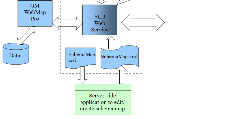
14 SLD Web Service Architecture Page 14
15 SLD Components The SLD engine a VB.NET-based web service SLD Web Service Provides the user a choice of routes Linearly referenced data to display Returns SVG file for route and requested attributes SLD Web Client Facilitates use of SLD Web Service Unlimited usage across enterprise On startup, this application populate a series of pulldown menus and list boxes from which the user selects a route and attributes User selects the Submit button and SLD file is created/displayed Page 15


16 SLD Web Client User selects the following to send to the SLD web service: LRS route Begin and end logmile Miles per sheet Attributes Attribute view Schematic view Page 16
17 SLD Layout Map View Map View: Route network display in planimetric view Tooltip of route information Backdrop information Highlight route section when attribute record selected Legend explaining symbology used in the map view Page 17
18 SLD Layout Schematic View Schematic View: True straight line view Symbols for events (bridge over, bridge under, intersection, etc.) Display relationships to connecting roads Dynamic measurement tool Page 18

19 SLD Layout Attribute View Attribute View: Display of multiple route attributes in sections Route attributes displayed from database Color coded representations of the selected events Directional Display Attribute dynamic segmentation in Map View Attribute tool tip Dynamic Measurement tool Page 19
20 Legend Symbols displayed in Schematic view Page 20
21 SVG Pop Up Menu Adobe SVG Viewer Right-click Item Page 21
22 SLD Print Studio Reposition the SLD Resize the SLD Add, reposition, or delete Title text Add labels by key-in Add labels by tool tip capture Set font characteristics for title text and labels Reposition, rotate, or delete added labels Move logos, titles and legend Page 22
23 SLD Print Studio Draw geometries (points, lines, and rectangles) Set user-added geometry characteristics (line weight, color, fill color, opacity) Move or resize user-added linear and area geometries Print drawing window contents (with changes) Adjust print output (widths and/or heights) from within SLDPrintStudio module Page 23
24 SLD Print Studio Page 24
25 SLD Web Service XML Configuration Connect to LRS and Event data from various sources and formats. No hard-coded table or field names Set symbology for Map View items (routes and backdrops) Set symbology in Schematic View for point and linear data Setup a Legend with user-defined names and symbols Define the tooltips for both LRS and Event data Predefine titles and logo for printing Set the labels for data entry fields in the client applications based on user requirements Page 25
26 SLD Web Service XML Configuration The XML configuration file has 6 major parts: MapView SchematicView AttributeView CoordinateSystemInfo PrintSVG OptimizeSLD Page 26
27 Summary Quick method of analyzing route data No GIS experience necessary for linear analysis Integrates into KGATE enterprise web portal Easily accessible throughout the KDOT enterprise Up to date decision support information Customized to KDOT s business needs Page 27
Intergraph Roadway Information Management Solution. Title Title. Title Title. A White Paper
 Intergraph Roadway Information Management Solution A White Paper Security, Government & Infrastructure, a division of Intergraph Title Title Title Title Table of Contents 1. Introduction... 1 2. Intergraph
GeoMedia Product Update. Title of Presentation. Lorilie Barteski October 15, 2008 Edmonton, AB
 Product Update Title of Presentation Lorilie Barteski Edmonton, AB Know the audience poll Existing /Pro users Version 6.1 Version 6.0 Version 5.2 or earlier Existing WebMap users Version 6.1 Version 6.0
6. If you want to enter specific formats, click the Format Tab to auto format the information that is entered into the field.
 Adobe Acrobat Professional X Part 3 - Creating Fillable Forms Preparing the Form Create the form in Word, including underlines, images and any other text you would like showing on the form. Convert the
ADMINISTRATORS GUIDE EPISUITE 6
 ADMINISTRATORS GUIDE EPISUITE 6 A quick tutorial on how to set up and implement Episuite Software created by IDentiphoto Specialists in IDentification 1810 Joseph Lloyd Pkwy. Willoughby, OH 44094 Phone:
Scientific Graphing in Excel 2010
 Scientific Graphing in Excel 2010 When you start Excel, you will see the screen below. Various parts of the display are labelled in red, with arrows, to define the terms used in the remainder of this overview.
ACS Version 10.6 - Check Layout Design
 ACS Version 10.6 - Check Layout Design Table Of Contents 1. Check Designer... 1 About the Check Design Feature... 1 Selecting a Check Template... 2 Adding a Check Template... 2 Modify a Check Template...
Create a Poster Using Publisher
 Contents 1. Introduction 1. Starting Publisher 2. Create a Poster Template 5. Aligning your images and text 7. Apply a background 12. Add text to your poster 14. Add pictures to your poster 17. Add graphs
Contents. The OWRB Floodplain Viewer. Creating Maps... 8. Helpful Tips... 10
 Contents QUICK START GUIDE... 2-5 Add layers...9 Search for Layers...9 COMPREHENSIVE GUIDE... 6 Navigate the map...6 Locate specific places...6 Add layer from file...9 Add layer from web...9 Display pop-up
Spatial Database Support
 Page 1 of 11 Spatial Database Support Global Mapper can import vector data from and export vector data to the following spatial databases: Esri ArcSDE Geodatabase Esri File Geodatabase Esri Personal Geodatabases
Help Document for WWW.SAGIS.ORG. Step by step, how-to instructions for navigating and using the Savannah Area GIS viewer.
 Help Document for WWW.SAGIS.ORG Step by step, how-to instructions for navigating and using the Savannah Area GIS viewer. 1 SAGIS Savannah Area GIS is focused on providing access to Geospatial data in a
Guide To Creating Academic Posters Using Microsoft PowerPoint 2010
 Guide To Creating Academic Posters Using Microsoft PowerPoint 2010 INFORMATION SERVICES Version 3.0 July 2011 Table of Contents Section 1 - Introduction... 1 Section 2 - Initial Preparation... 2 2.1 Overall
WFP Liberia Country Office
 1 Oscar Gobbato oscar.gobbato@wfp.org oscar.gobbato@libero.it WFP Liberia Country Office GIS training - Summary Objectives 1 To introduce to participants the basic concepts and techniques in using Geographic
Canterbury Maps Quick Start - Drawing and Printing Tools
 Canterbury Maps Canterbury Maps Quick Start - Drawing and Printing Tools Quick Start Guide Standard GIS Viewer 2 Canterbury Maps Quick Start - Drawing and Printing Tools Introduction This document will
Tyler Dashboard. User Guide Version 6.2. For more information, visit www.tylertech.com.
 Tyler Dashboard User Guide Version 6.2 For more information, visit www.tylertech.com. TABLE OF CONTENTS Tyler Dashboard... 3 Tyler Dashboard Features... 3 Site Search... 3 Browse... 4 Page... 5 Dashboard...
Printing Bar Code and RFID Labels from Oracle
 Printing Bar Code and RFID Labels from Oracle Overview The EASYLABEL XML Monitor allows you to automatically print to your current label and RFID printers from an Oracle WMS/MSCA system. A direct connection
Y R T S TransporTaTion U D IN solutions
 I N D U S T R Y Transportation Solutions Keeping people and products moving safely and efficiently In a world of constant change, keeping people and products moving safely and efficiently is a complex,
Chapter 23: Drafting in Worksheet View
 Chapter 23: Drafting in Worksheet View Worksheet View is a powerful, 2D production drafting module. Here you can find all of the drawing and editing tools needed to create fast, accurate, detailed working
Introduction to the TI-Nspire CX
 Introduction to the TI-Nspire CX Activity Overview: In this activity, you will become familiar with the layout of the TI-Nspire CX. Step 1: Locate the Touchpad. The Touchpad is used to navigate the cursor
Copyright 2006 TechSmith Corporation. All Rights Reserved.
 TechSmith Corporation provides this manual as is, makes no representations or warranties with respect to its contents or use, and specifically disclaims any expressed or implied warranties or merchantability
I ntroduction. Accessing Microsoft PowerPoint. Anatomy of a PowerPoint Window
 Accessing Microsoft PowerPoint To access Microsoft PowerPoint from your home computer, you will probably either use the Start menu to select the program or double-click on an icon on the Desktop. To open
Ovation Operator Workstation for Microsoft Windows Operating System Data Sheet
 Ovation Operator Workstation for Microsoft Windows Operating System Features Delivers full multi-tasking operation Accesses up to 200,000 dynamic points Secure standard operating desktop environment Intuitive
NatureServe s Environmental Review Tool
 NatureServe s Environmental Review Tool A Repeatable Online Software Solution for Agencies For More Information, Contact: Lori Scott Rob Solomon lori_scott@natureserve.org rob_solomon@natureserve.org 703-908-1877
Tic, Tie & Calculate Quick Start Guide. Quick Start Guide
 Quick Start Guide 1 Table of Contents Quick Start Guide... 3 Welcome to Tic, Tie & Calculate... 3 Features Overview... 3 Important Installation Notes... 3 Installation... 4 Step 1: Receive Account Creation
INTRODUCTION to ESRI ARCGIS For Visualization, CPSC 178
 INTRODUCTION to ESRI ARCGIS For Visualization, CPSC 178 1) Navigate to the C:/temp folder 2) Make a directory using your initials. 3) Use your web browser to navigate to www.library.yale.edu/mapcoll/ and
HPMS Version 8.0 Software Guide. Highway Performance Monitoring System Software Guide for Version 8.0
 Highway Performance Monitoring System Software Guide for Version 8.0 1 Contents Chapter 1 Introduction...1 Key to Symbols and Text Notices in this Guide...1 Chapter 2 HPMS Workflow... 2 Chapter 3 HPMS
Creating Interactive PDF Forms
 Creating Interactive PDF Forms Using Adobe Acrobat X Pro Information Technology Services Outreach and Distance Learning Technologies Copyright 2012 KSU Department of Information Technology Services This
CONVERSION GUIDE Financial Statement Files from CSA to Accounting CS
 CONVERSION GUIDE Financial Statement Files from CSA to Accounting CS Introduction and conversion program overview... 1 Conversion considerations and recommendations... 1 Conversion procedures... 2 Data
Excel -- Creating Charts
 Excel -- Creating Charts The saying goes, A picture is worth a thousand words, and so true. Professional looking charts give visual enhancement to your statistics, fiscal reports or presentation. Excel
Integrating GIS-Based Videolog and Asset Data With Commonly Used Systems Provides Major Benefits With Minimal Effort
 Integrating GIS-Based Videolog and Asset Data With Commonly Used Systems Provides Major Benefits With Minimal Effort Presented By: Debbie Burns, GIS Manager Michael Nieminen, Project Manager Introduction
Google Docs Basics Website: http://etc.usf.edu/te/
 Website: http://etc.usf.edu/te/ Google Docs is a free web-based office suite that allows you to store documents online so you can access them from any computer with an internet connection. With Google
Create Charts in Excel
 Create Charts in Excel Table of Contents OVERVIEW OF CHARTING... 1 AVAILABLE CHART TYPES... 2 PIE CHARTS... 2 BAR CHARTS... 3 CREATING CHARTS IN EXCEL... 3 CREATE A CHART... 3 HOW TO CHANGE THE LOCATION
3D-GIS in the Cloud USER MANUAL. August, 2014
 3D-GIS in the Cloud USER MANUAL August, 2014 3D GIS in the Cloud User Manual August, 2014 Table of Contents 1. Quick Reference: Navigating and Exploring in the 3D GIS in the Cloud... 2 1.1 Using the Mouse...
Microsoft Office Excel 2007 Key Features. Office of Enterprise Development and Support Applications Support Group
 Microsoft Office Excel 2007 Key Features Office of Enterprise Development and Support Applications Support Group 2011 TABLE OF CONTENTS Office of Enterprise Development & Support Acknowledgment. 3 Introduction.
Data Visualization. Prepared by Francisco Olivera, Ph.D., Srikanth Koka Department of Civil Engineering Texas A&M University February 2004
 Data Visualization Prepared by Francisco Olivera, Ph.D., Srikanth Koka Department of Civil Engineering Texas A&M University February 2004 Contents Brief Overview of ArcMap Goals of the Exercise Computer
Microsoft Dynamics GP. Advanced Financial Analysis
 Microsoft Dynamics GP Advanced Financial Analysis Copyright Copyright 2010 Microsoft. All rights reserved. Limitation of liability This document is provided as-is. Information and views expressed in this
User s Guide to ArcView 3.3 for Land Use Planners in Puttalam District
 User s Guide to ArcView 3.3 for Land Use Planners in Puttalam District Dilhari Weragodatenna IUCN Sri Lanka, Country Office Table of Content Page No Introduction...... 1 1. Getting started..... 2 2. Geo-referencing...
Choosing the Right BarTender Edition
 White Paper Choosing the Right BarTender Edition Edition Summary and Feature Comparison Chart Comparing the Five Editions Enterprise Licensing: All three Enterprise editions allow unlimited network users.
Using CAD Data in ArcGIS
 Esri International User Conference San Diego, California Technical Workshops July 27, 2012 Using CAD Data in ArcGIS Jeff Reinhart & Phil Sanchez Agenda Overview of ArcGIS CAD Support Using CAD Datasets
Creating detailed drawings
 Creating detailed drawings Publication Number spse01545 Creating detailed drawings Publication Number spse01545 Proprietary and restricted rights notice This software and related documentation are proprietary
Documentation of open source GIS/RS software projects
 Contract no. Workpackage Delivery Delivery Date 030776 WP1 D1.6 2007-07-02 CASCADOSS Development of a trans-national cascade training programme on Open Source GIS&RS Software for environmental applications
The Dashboard. Change ActivInspire's Look And Feel. ActivInspire Primary. ActivInspire Studio. <- Primary. Studio -> page 1
 page 1 The Dashboard When ActivInspire opens, you are immediately greeted with the Dashboard. The Dashboard contains shortcuts to flipcharts and time-saving tools. The Dashboard remains open until it is
Xerox 700 Digital Color Press with Integrated Fiery Color Server. Utilities
 Xerox 700 Digital Color Press with Integrated Fiery Color Server Utilities 2008 Electronics for Imaging, Inc. The information in this publication is covered under Legal Notices for this product. 45072726
Asset Track Getting Started Guide. An Introduction to Asset Track
 Asset Track Getting Started Guide An Introduction to Asset Track Contents Introducing Asset Track... 3 Overview... 3 A Quick Start... 6 Quick Start Option 1... 6 Getting to Configuration... 7 Changing
Introduction to dobe Acrobat XI Pro
 Introduction to dobe Acrobat XI Pro Introduction to Adobe Acrobat XI Pro is licensed under the Creative Commons Attribution-NonCommercial-NoDerivatives 4.0 International License. To view a copy of this
Dell SE2716H Monitor Dell Display Manager User s Guide
 Dell SE2716H Monitor Dell Display Manager User s Guide Model: SE2716H Regulatory model: SE2716Ht NOTE: A NOTE indicates important information that helps you make better use of your computer. Copyright
What s New in QuarkXPress 8
 What s New in QuarkXPress 8 LEGAL NOTICES 2008 Quark Inc. as to the content and arrangement of this material. All rights reserved. 1986 2008 Quark Inc. and its licensors as to the technology. All rights
ArcGIS. Tips and Shortcuts. for Desktop
 ArcGIS Tips and Shortcuts for Desktop Map Navigation Refresh and redraw the display. F5 Suspend the map s drawing. F9 Zoom in and out. Center map. Roll the mouse wheel backward and forward. Hold down Ctrl
Writer Guide. Chapter 15 Using Forms in Writer
 Writer Guide Chapter 15 Using Forms in Writer Copyright This document is Copyright 2005 2008 by its contributors as listed in the section titled Authors. You may distribute it and/or modify it under the
Shipment Label Header Guide
 Shipment Label Header Guide This guide will walk you through the 3 main phases of setting up a shipment label header within World Ship 2013. This guide was made using standard Windows Microsoft Office
Excel 2007 Basic knowledge
 Ribbon menu The Ribbon menu system with tabs for various Excel commands. This Ribbon system replaces the traditional menus used with Excel 2003. Above the Ribbon in the upper-left corner is the Microsoft
Using HTML5 Pack for ADOBE ILLUSTRATOR CS5
 Using HTML5 Pack for ADOBE ILLUSTRATOR CS5 ii Contents Chapter 1: Parameterized SVG.....................................................................................................1 Multi-screen SVG.......................................................................................................4
Charts for SharePoint
 KWizCom Corporation Charts for SharePoint Admin Guide Copyright 2005-2015 KWizCom Corporation. All rights reserved. Company Headquarters 95 Mural Street, Suite 600 Richmond Hill, ON L4B 3G2 Canada E-mail:
Publisher 2010 Cheat Sheet
 April 20, 2012 Publisher 2010 Cheat Sheet Toolbar customize click on arrow and then check the ones you want a shortcut for File Tab (has new, open save, print, and shows recent documents, and has choices
How To Create A View Frame In 3D
 12/4/2008-10:00 am - 11:30 am Room:Palazzo O-P (5th) The Secrets of Cutting Plan and Profile Sheets in AutoCAD Civil 3D Michelle Rasmussen - Application Engineer, IMAGINiT Technologies CV304-1P In this
Hotspot Image Connector Page Guide
 Contents Differences between Xerte and Xerte Online Toolkits usage...2 Connector pages...2 The Hotspot Image Connector page...2 Properties of the Hotspot Image Connector Page...3 Hotspot Properties...3
Barcode Labels Feature Focus Series. POSitive For Windows
 Barcode Labels Feature Focus Series POSitive For Windows Inventory Label Printing... 3 PFW System Requirement for Scanners... 3 A Note About Barcode Symbologies... 4 An Occasional Misunderstanding... 4
Chapter 15 Using Forms in Writer
 Writer Guide Chapter 15 Using Forms in Writer OpenOffice.org Copyright This document is Copyright 2005 2006 by its contributors as listed in the section titled Authors. You can distribute it and/or modify
Web and Mobile GIS in Local Authorities in Ireland Ciarán Kirk, IMGS
 Web and Mobile GIS in Local Authorities in Ireland Ciarán Kirk, IMGS We deliver innovative spatial solutions for the desktop, web & mobile Built on our partner s technology Designed to meet the challenges
Virto SharePoint Gantt Chart Web Part for SharePoint 2013 Release 4.3.0. User and Installation Guide
 Virto SharePoint Gantt Chart Web Part for SharePoint 2013 Release 4.3.0 User and Installation Guide Table of Contents FEATURES LIST... 3 SYSTEM/DEVELOPER REQUIREMENTS... 3 OPERATING SYSTEM... 3 SERVER...
Updox, LLC support@updox.com 614-547-9635
 Set Up and User Guide Version 3.2.2 Updox, LLC support@updox.com 614-547-9635 Table of Contents Creating and Managing Internal Updox Users... 3 How to Send and Receive Faxes... 4 How to Import Files into
SAS/GRAPH 9.2 ODS Graphics Editor. User s Guide
 SAS/GRAPH 9.2 ODS Graphics Editor User s Guide The correct bibliographic citation for this manual is as follows: SAS Institute Inc. 2009. SAS/GRAPH 9.2: ODS Graphics Editor User's Guide. Cary, NC: SAS
Avery DesignPro 2000 User Guide
 Avery DesignPro 2000 User Guide Creating labels and cards for your personal needs is easy with Avery DesignPro 2000 Avery DesignPro 2000 User Guide First edition of the condensed user manual for Avery
Microsoft Excel 2010 Charts and Graphs
 Microsoft Excel 2010 Charts and Graphs Email: training@health.ufl.edu Web Page: http://training.health.ufl.edu Microsoft Excel 2010: Charts and Graphs 2.0 hours Topics include data groupings; creating
KANSAS TRUCK ROUTING INTELLIGENT PERMITTING SYSTEM
 KANSAS TRUCK ROUTING INTELLIGENT PERMITTING SYSTEM KS Company User Guide This user guide describes the operational procedures for K-TRIPS and the screens encountered by users during those procedures. Motor
Using Microsoft Word. Working With Objects
 Using Microsoft Word Many Word documents will require elements that were created in programs other than Word, such as the picture to the right. Nontext elements in a document are referred to as Objects
Lession: 2 Animation Tool: Synfig Card or Page based Icon and Event based Time based Pencil: Synfig Studio: Getting Started: Toolbox Canvas Panels
 Lession: 2 Animation Tool: Synfig In previous chapter we learn Multimedia and basic building block of multimedia. To create a multimedia presentation using these building blocks we need application programs
How To Change Your Site On Drupal Cloud On A Pcode On A Microsoft Powerstone On A Macbook Or Ipad (For Free) On A Freebie (For A Free Download) On An Ipad Or Ipa (For
 On A Freebie (For A Free Download) On An Ipad Or Ipa (For") How-to Guide: MIT DLC Drupal Cloud Theme This guide will show you how to take your initial Drupal Cloud site... and turn it into something more like this, using the MIT DLC Drupal Cloud theme. See this
How-to Guide: MIT DLC Drupal Cloud Theme This guide will show you how to take your initial Drupal Cloud site... and turn it into something more like this, using the MIT DLC Drupal Cloud theme. See this
Tutorial 2: Using Excel in Data Analysis
 Tutorial 2: Using Excel in Data Analysis This tutorial guide addresses several issues particularly relevant in the context of the level 1 Physics lab sessions at Durham: organising your work sheet neatly,
Creating a Poster in PowerPoint 2010. A. Set Up Your Poster
 View the Best Practices in Poster Design located at http://www.emich.edu/training/poster before you begin creating a poster. Then in PowerPoint: (A) set up the poster size and orientation, (B) add and
An Esri White Paper July 2010 Highway Data Management in ArcGIS
 An Esri White Paper July 2010 Highway Data Management in ArcGIS Esri, 380 New York St., Redlands, CA 92373-8100 USA TEL 909-793-2853 FAX 909-793-5953 E-MAIL info@esri.com WEB www.esri.com Copyright 2010
Microsoft Office Publisher 2010
 1 Microsoft Office Publisher 2010 Microsoft Publisher is a desktop publishing application which allows you to create artistic documents as brochures, flyers, and newsletters. To open Microsoft Office Publisher:
Table of Contents 2. Table of Contents
 Scanning Options Table of Contents 2 Table of Contents Scanning Overview and Setup... 3 Scanning Tools and Equipment... 3 File Locations... 4 Other Settings... 5 Scanning Options and Techniques... 6 Scanned
TLMC WORKSHOP: THESIS FORMATTING IN WORD 2010
 Table of Contents Introduction... 2 Getting Help... 2 Tips... 2 Working with Styles... 3 Applying a Style... 3 Choosing Which Styles to Use... 3 Modifying a Style... 4 Creating A New Style... 4 Setting
Setup Commander. Administration Guide 1.0.0. Copyright 2013, ROVABU Software B.V. Version 1.0.0. Page 1
 Setup Commander Administration Guide 1.0.0 Copyright 2013, ROVABU Software B.V. Version 1.0.0. Page 1 Copyright, Trademarks, and Legal ROVABU Software B.V. www.setupcommander.com June 25th, 2013 Copyright
KDOT s Spatially Enabled Data Warehouse. Paul Bayless KDOT Data Warehouse Manager and Bill Schuman GeoDecisions Project Manager
 KDOT s Spatially Enabled Data Warehouse Paul Bayless KDOT Data Warehouse Manager and Bill Schuman GeoDecisions Project Manager Goals of the Session Describe what a data warehouse is and why it is of value
Kitchen and Bath Design Tutorial
 Adding Cabinets Chapter 5: Kitchen and Bath Design Tutorial This tutorial continues where the Materials Tutorial left off. You should save this tutorial using a new name to archive your previous work.
Legal Notes. Regarding Trademarks. Model supported by the KX printer driver. 2010 KYOCERA MITA Corporation
 Legal Notes Unauthorized reproduction of all or part of this guide is prohibited. The information in this guide is subject to change for improvement without notice. We cannot be held liable for any problems
Basic tutorial for Dreamweaver CS5
 Basic tutorial for Dreamweaver CS5 Creating a New Website: When you first open up Dreamweaver, a welcome screen introduces the user to some basic options to start creating websites. If you re going to
Laser Cutter User Manual
 Laser Cutter User Manual frequently asked questions... the laser is cutting weird! it s cutting a thick line or not cutting through at all! Table Of Contents Section 1: Materials Guide 1.1 Can I Cut this?
Build Your First Web-based Report Using the SAS 9.2 Business Intelligence Clients
 Technical Paper Build Your First Web-based Report Using the SAS 9.2 Business Intelligence Clients A practical introduction to SAS Information Map Studio and SAS Web Report Studio for new and experienced
Spatially Enabling an Asset Management Database
 Spatially Enabling an Asset Management Database John Woollett, GIS Manager (Operations) Tube Lines Ralph Diment Intergraph UK Helen Neaves Intergraph UK Bruce Aquila Intergraph Introduction Background
Hummingbird BI BI Query Queries User s Guide
 Hummingbird BI BI Query Queries User s Guide BI Query Queries User s Guide Version: 9.0.1 Part Number: 8697-2M February 2006 Hummingbird Ltd. 1 Sparks Avenue, Toronto, Ontario, Canada M2H 2W1 Tel: +1 416
Oracle Database 10g: Building GIS Applications Using the Oracle Spatial Network Data Model. An Oracle Technical White Paper May 2005
 Oracle Database 10g: Building GIS Applications Using the Oracle Spatial Network Data Model An Oracle Technical White Paper May 2005 Building GIS Applications Using the Oracle Spatial Network Data Model
EPM Performance Suite Profitability Administration & Security Guide
 BusinessObjects XI R2 11.20 EPM Performance Suite Profitability Administration & Security Guide BusinessObjects XI R2 11.20 Windows Patents Trademarks Copyright Third-party Contributors Business Objects
Microsoft PowerPoint 2010 Computer Jeopardy Tutorial
 Microsoft PowerPoint 2010 Computer Jeopardy Tutorial 1. Open up Microsoft PowerPoint 2010. 2. Before you begin, save your file to your H drive. Click File > Save As. Under the header that says Organize
NiceLabel Designer Standard User Guide
 NiceLabel Designer Standard User Guide English Edition Rev-1112 2012 Euro Plus d.o.o. All rights reserved. Euro Plus d.o.o. Poslovna cona A 2 SI-4208 Šenčur, Slovenia tel.: +386 4 280 50 00 fax: +386 4
HELCOM Data and Map Service. User Manual
 HELCOM Data and Map Service User Manual Version 2.2 - February 2015 1 Table of contents 1. General Information... 3 1.1 Background... 3 1.2 Technical requirements... 3 1.3 Contact... 3 2. Accessing HELCOM
Dream Report Version 4.5
 Dream Report Version 4.5 Project Upgrade Procedure 1 P a g e Contents Introduction... 3 Upgrade Steps... 3 1. Backup of the Existing Project... 3 2. Installation of Dream Report Version 4.5... 3 3. Loading
Graphic Design Studio Guide
 Graphic Design Studio Guide This guide is distributed with software that includes an end-user agreement, this guide, as well as the software described in it, is furnished under license and may be used
Handout: Word 2010 Tips and Shortcuts
 Word 2010: Tips and Shortcuts Table of Contents EXPORT A CUSTOMIZED QUICK ACCESS TOOLBAR... 2 IMPORT A CUSTOMIZED QUICK ACCESS TOOLBAR... 2 USE THE FORMAT PAINTER... 3 REPEAT THE LAST ACTION... 3 SHOW
Halifax Water Hydrant and Catchbasin Interactive Mapping USER GUIDE. Halifax Water Hydrant & Catchbasin Interactive Mapping USER GUIDE Page 1
 Halifax Water Hydrant and Catchbasin Interactive Mapping USER GUIDE Halifax Water Hydrant & Catchbasin Interactive Mapping USER GUIDE Page 1 Navigation Tools These tools may be used to maneuver your way
Kitchen and Bath Design Tutorial
 Adding Cabinets Kitchen and Bath Design Tutorial This tutorial continues where the Interior Design Tutorial left off. You should save this tutorial using a new name to archive your previous work. The tools
Microsoft Word 2010 Prepared by Computing Services at the Eastman School of Music July 2010
 Microsoft Word 2010 Prepared by Computing Services at the Eastman School of Music July 2010 Contents Microsoft Office Interface... 4 File Ribbon Tab... 5 Microsoft Office Quick Access Toolbar... 6 Appearance
13 Managing Devices. Your computer is an assembly of many components from different manufacturers. LESSON OBJECTIVES
 LESSON 13 Managing Devices OBJECTIVES After completing this lesson, you will be able to: 1. Open System Properties. 2. Use Device Manager. 3. Understand hardware profiles. 4. Set performance options. Estimated
SMART Ink 1.5. Windows operating systems. Scan the following QR code to view the SMART Ink Help on your smart phone or other mobile device.
 SMART Ink 1.5 Windows operating systems User s guide Scan the following QR code to view the SMART Ink Help on your smart phone or other mobile device. Trademark notice SMART Ink, SMART Notebook, SMART
Linear Referencing Tutorial
 Copyright 1995-2010 Esri All rights reserved. Table of Contents An overview of the linear referencing tutorial........................ 3 Exercise 1: Organizing your linear referencing data in ArcCatalog...............
APC Application Suite. Installation and Setup Guide Version 4.01
 APC Application Suite Installation and Setup Guide Version 4.01 Table of Contents Chapter 1 - Introduction... 1-1 How The System is Constructed...1-1 Chapter 2 - Installation and Setup... 2-1 Installing
Microsoft Dynamics GP. Collections Management
 Microsoft Dynamics GP Collections Management Copyright Copyright 2010 Microsoft. All rights reserved. Limitation of liability This document is provided as-is. Information and views expressed in this document,
Embroidery Fonts Plus ( EFP ) Tutorial Guide Version 1.0505
 Tutorial Guide Version 1.0505") Embroidery Fonts Plus ( EFP ) Tutorial Guide Version 1.0505 1 Contents Chapter 1 System Requirements.................. 3 Chapter 2 Quick Start Installation.................. 4 System Requirements................
Embroidery Fonts Plus ( EFP ) Tutorial Guide Version 1.0505 1 Contents Chapter 1 System Requirements.................. 3 Chapter 2 Quick Start Installation.................. 4 System Requirements................
GeoMedia Smart Client
 GEOSPATIAL GeoMedia Smart Client Dynamically Jumpstart Your GIS GeoMedia Smart Client Is your geographic information system (GIS) at a gridlock, stuck in a department, limited to a few, contained and