COSTE: a Web-Services Infrastructure Enabling Interoperability and Integration of Spatial and Traffic e-contents for European Regions
|
|
|
- Aleesha Carroll
- 8 years ago
- Views:
Transcription
1 COSTE: a Web-s Infrastructure Enabling Interoperability and Integration of Spatial and Traffic e-contents for European Regions Marco Boero Softeco Sismat SpA Italy

2 Geographic Information: Motivation, problem area GI is any information about the location and shape of, and relationships among, geographic features. This includes remotely sensed data as well as map data. (Open Geospatial Consortium) A highly relevant asset in many sectors and activities: earth sciences, real properties & land information, risk management, e-government, mobile enterprise, Focus area: combined geographic and traffic digital contents

3 Motivation, problem area A growing world of applications, an expanding market In-car navigation and route guidance Location-based services (e.g. tourism,...) Traffic management and control and infrastructures management Event management (e.g. disasters,...) Traffic and land use planning... Base data owned mainly by Public Administrations High potentials, but limitations to full exploitation e.g. poor accessibility: data organised and kept in different ways by the different owners poor interoperability: not compatible formats and data models lack of standardised interfaces


4 Research Objectives, a Definition Phase project under, to investigate, define and evaluate the feasibility of a technical infrastructure (data + services) and of the associated operational models allowing efficient combination of spatial and traffic data integration of data from different content servers over the internet access to these maps for different user categories support for VAS Experimental Use Cases Urban (Genoa, IT) Regional (Northrhine- Westphalia, DE) Content server Content server Content server
 Regional (Northrhine- Westphalia, DE) Content server Content server")

 Internet Internet Internet Police Urban TCC info /")
5 COSTE standard interfaces COSTE services The reference service/value chain Research approach, Methodology Content Provider Content Integrators Value Added Providers Operators End Users Admin. COSTE services (product management) Internet Internet Internet Police Urban TCC info / content COSTE integration Value Added provision DATEX-Net RDS/TMC Motroway TCC ALERT-C
 Internet Internet Internet Police Urban TCC info /")
 COSTE End-users COSTE standard interface (OGC, web services, ) COSTE Maps production services internet")
 Web Map Server (WMS) maps traffic mobility.. geographic data land use.. environment utilities & technological systems.")
6 Research approach, Methodology The reference application environment Meta-data server metadata registries COSTE Application server COSTE end-user services COSTE-enabled Applications Value Added s ( access to COSTE end-user services ) COSTE End-users COSTE standard interface (OGC, web services, ) COSTE Maps production services internet infrastructure COSTE standard interface (OGC, webservices, ) COSTE standard interface (OGC, webservices, ) COSTE standard interface (OGC, webservices, ) COSTE standard interface (OGC, webservices, ) Web Map Server (WMS) maps traffic mobility.. geographic data land use.. environment utilities & technological systems.. logical functional physical geographical distribution
 Web Map Server (WMS) maps traffic mobility.. geographic data land use.. environment utilities & technological systems.")

7 Research approach, Methodology Key requirements and design decisions A truly, largely distributed environment functional / physical / organisational / geographical / distribution Data have to stay where they normally are at owner s premises! Make data (more) visible use of meta-data, registry/catologue services, An open service architecture framework an intrinsically dynamic context Relevant standards and SDIs initiatives GI: ISO/DIS 19xxx, OGC (ORM), GML (ISO/OGC), road/traffic: GDF (ISO/DIS 14825), DATEX, EU SDI Initiative INSPIRE
, GML (ISO/OGC), road/traffic: GDF (ISO/DIS")
 to support delivery of COSTE Information Products generate publish and make usable production of CosteMaps Products: CosteMaps Costes Customer")
8 Costes Major Outcomes/Results A multi-service, open, middleware achitecture providing: Content Servers modular, geo/traffic engineering combined Information Products: CosteMaps, CosteProducts a set of web services ( Costes ) to support delivery of COSTE Information Products generate publish and make usable production of CosteMaps Products: CosteMaps Costes Customer COSTE Server

 COSTE reference")
9 Major Outcomes/Results The COSTE reference contents & base services Reference Traffic infrastructure data Traffic data Parking data Public transport data Incident/Event messages work data Environment data Cultural/sport event data Weather data COSTE reference content areas Location Referencing Transformation Data Routing Portrayal Routing Portrayal OGC Web s Framework (OSF) COSTE reference services
 COSTE reference")
10 Major Outcomes/Results The underlying OGC Web s Framework (OSF) Registry s Data s Portrayal s Processing s Digital Rights Management s (see Location Referencing Transformation Data Routing Portrayal Routing Portrayal Coste OSF Comment category COSTE Catalogue s Catalogue Implement read-type as well as write-type operations COSTE Sensor Collection s Sensor Collection Fully OGC compliant COSTE Data s Data Provide data access (data servers or DBs) COSTE Portrayal s Portrayal Map creation and manipulation. OGC and SLD compliant COSTE Routing s Processing Used on eg read network, public transport, ) COSTE Watchdog s Processing Notify event occurrence to users or other services COSTE Location Referencing Transformation s COSTE Digital Rights Management s Processing DRM Perform transformations between different road networks, coord. reference systems, etc. Authentication of users and services to access geospatial objects. GeoDRM ongoing standard definition
 COSTE Watchdog s Processing Notify event occurrence to users or other services COSTE Location Referencing")
11 Major Outcomes/Results Costes: service operation and chaining models Find Broker Publish Requestor Bind Provider Client Standard publish/find/bind pattern dynamic binding Chain 1. invoke service 2. invoke service Aggregate 5. service results 4a. invoke service aggregation base Costes combined into higher-level end-user services 3a. invoke service 3b. request input 4b. request input 4c. request input

12 Major Outcomes/Results: proof-of-concept Strategy Manager (mometec GmbH) TIC NRW NRW Public SurveyingAgency GDF (ii GmbH) Web Map Server (WMS) Aachen Düsseldorf COSTE Application server COSTE end-user services Bonn Comune di Genova Map s Genoa COSTE Maps production services interactive instruments GmbH Web Map Server (WMS)

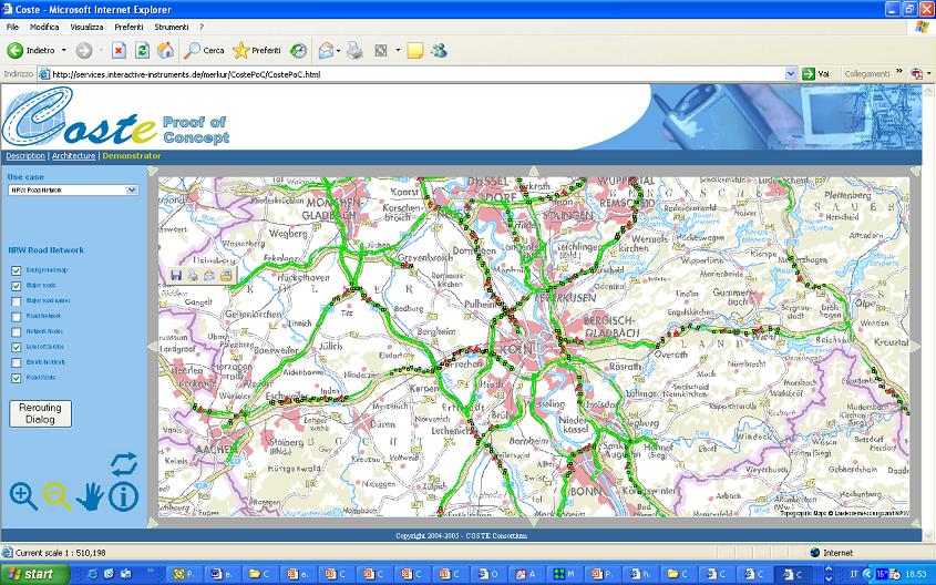
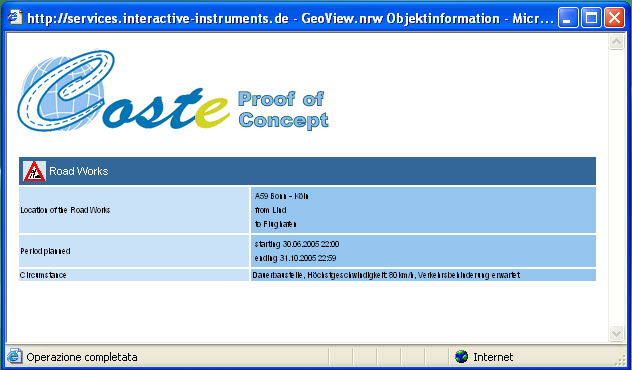
13 Major Outcomes/Results : proof-of-concept Web Map Server (WMS)

14 Main conclusions Conclusion and outlook The Definition Phase project investigated fundamental needs in geo/traffic info market on-line integration of contents large impacts on apps/services Overall viability of the approach proven proof-of-concept larger scale demonstration Content analysis identified base requirements More work needed on common semantics geo/traffic ontologies Standards are fundamental!! ISO 19xxx, OGC, road/traffic (GDF, ) The (short term) future emotion Project: Europe-wide multi-modal on-trip traffic information FP6-DGTREN, to start early partners, 7 EU countries full service-value chain covered
 The (short term) future emotion Project: Europe-wide multi-modal on-trip traffic information FP6-DGTREN, to start")
15 Conclusion and outlook The COSTE website Contacts Marco Boero, Softeco The COSTE Partners Softeco Sismat SpA (I) momatec GmbH (D) interactive instruments GmbH (D) Comune di Genova (I) MVEL, Ministry NorthRhine-Westphalia (D) Thank you for attention!
 Comune di Genova (I) MVEL, Ministry")
Quality of Service in a Global SDI
 Quality of Service in a Global SDI Ingo SIMONIS and Adam SLIWINSKI, Germany Key words: Quality of Service, Spatial Data Infrastructure, Service Monitor SUMMARY During the last years, a lot of effort was
INSPIRE Infrastructure for Spatial Information in Europe. INSPIRE Network Services Architecture. Network Services Architecture Creator.
 INSPIRE Infrastructure for Spatial Information in Europe Title Network Creator Network Drafting Team Date 19-07-2008 Subject Status Draft Publisher Network Drafting Team Type Text Description Network describes
GetLOD - Linked Open Data and Spatial Data Infrastructures
 GetLOD - Linked Open Data and Spatial Data Infrastructures W3C Linked Open Data LOD2014 Roma, 20-21 February 2014 Stefano Pezzi, Massimo Zotti, Giovanni Ciardi, Massimo Fustini Agenda Context Geoportal
Francesco Tortorelli
 Francesco Tortorelli Joint CEN/TC 287 and OGC Workshop Bringing GI Standards-making bodies together Frascati (Rome), 30 September 2013 (AgID) AgID (previously CNIPA and DigitPA) is a government agency
UK Location Programme
 Location Information Interoperability Board Data Publisher How To Guide Understand the background to establishing an INSPIRE View Service using GeoServer DOCUMENT CONTROL Change Summary Version Date Author/Editor
Enabling embedded maps
 Enabling embedded maps Case: National geoportal of Finland Antti Rainio National Land Survey of Finland Trends: Web Services, Mapping Mashup, Open Source, Open Data Decentralised data s Service interfaces
Geospatial Portal Reference Architecture
 Geospatial Portal Reference Architecture DRAFT OGC 04-039 Open Geospatial Consortium Inc. Date: 2004-07-02 Reference number of this OpenGIS document: OGC 04-039 Version: 0.2 Category: OpenGIS Discussion
13 th EC GI & GIS Workshop WIN: A new OGC compliant SOA. for risk management. GMV, 2007 Property of GMV All rights reserved
 13 th EC GI & GIS Workshop WIN: A new OGC compliant SOA for risk management GMV, 2007 Property of GMV All rights reserved Content 1. Introduction 2. Objectives 3. Architecture and Model 4. Technical aspects
Introduction to the Mapbender OWS Security Proxy
 Introduction to the Mapbender OWS Security Proxy Arnulf Christl, WhereGroup GmbH & Co. KG, Bonn, Germany 1/16 Agenda 1 Introduction to the Architecture OWS from Bottom Up with the OSGeo SDI Software Stack
OPEN STANDARD WEB SERVICES FOR VISUALISATION OF TIME SERIES DATA OF FLOOD MODELS
 OPEN STANDARD WEB SERVICES FOR VISUALISATION OF TIME SERIES DATA OF FLOOD MODELS Barend Köbben FRMRC RPA 7 Workshop visualisations and flow simulations as flood risk communication tools
Thomas Usländer Fraunhofer IITB
 ORCHESTRA Day Stresa, 12 December 2007 ORCHESTRA Architecture - Behind the Scenes Thomas Usländer Fraunhofer IITB ORCHESTRA Consortium ORCHESTRA Ambition Analysis Maps Info Centre Archive Control centre
Spatial Data Infrastructure. A Collaborative Network
 Spatial Data Infrastructure A Collaborative Network Solving Challenges Takes Collaboration Social challenges, environmental issues, and economic downturns all take cooperation to solve. Working together
CDI/THREDDS Interoperability: the SeaDataNet developments. P. Mazzetti 1,2, S. Nativi 1,2, 1. CNR-IMAA; 2. PIN-UNIFI
 CDI/THREDDS Interoperability: the SeaDataNet developments P. Mazzetti 1,2, S. Nativi 1,2, 1. CNR-IMAA; 2. PIN-UNIFI Outline Interoperability Issues in SeaDataNet A broker solution for CDI/THREDDS interoperability
Chaining Façades: Higher Efficiency in evolution-enabled Spatial Data Infrastructures (SDI)
") Chaining Façades: Higher Efficiency in evolution-enabled Spatial Data Infrastructures (SDI) Roland M. Wagner Fraunhofer ISST, Berlin/Dortmund, Germany ABSTRACT After the first publication of the known
Chaining Façades: Higher Efficiency in evolution-enabled Spatial Data Infrastructures (SDI) Roland M. Wagner Fraunhofer ISST, Berlin/Dortmund, Germany ABSTRACT After the first publication of the known
Task AR-09-01a Progress and Contributions
 Doug Nebert, POC U.S. Geological Survey ddnebert@usgs.gov March 2010 Task AR-09-01a Progress and Contributions Background and scope for AR-09-01a This Task defines the minimum, common technical capabilities
Building a SDI for small countries the Portuguese example
 Building a SDI for small countries the Portuguese example Rui Pedro Julião Instituto Geográfico Português Deputy Director-General rpj@igeo.pt Abstract Portugal was one of the SDI pioneers in the beginning
Cadastre in the context of SDI and INSPIRE
 Cadastre in the context of SDI and INSPIRE Dr. Markus Seifert Bavarian Administration for Surveying and Cadastre Cadastre in the digital age the approach in Germany 3 rd CLGE Conference, Hanover, 11.10.2012
PDOK Kaart, the Dutch Mapping API
 PDOK Kaart, the Dutch Mapping API Haico van der Vegt*, Leo van der Sluijs* * Cadastre, Land Registry and Mapping Agency of the Netherlands Abstract. PDOK (public services on the map) is a partnership of
From Geoportal to Spatial Data Service Platform. Jani Kylmäaho National Land Survey of Finland Development Centre
 From Geoportal to Spatial Data Service Platform Jani Kylmäaho National Land Survey of Finland Development Centre 29.6.2012 Introduction National Land Survey of Finland - 1900 employees Development Centre
Applying Semantic Web Technologies in Service-Oriented Architectures
 Applying Semantic Web Technologies in Service-Oriented Architectures 24 August 2015 Semantic Web for Air Transportation (SWAT) Luis Bermudez - OGC Charles Chen - Skymantics Copyright 2015 Open Geospatial
Data Models For Interoperability. Rob Atkinson
 Data Models For Interoperability Rob Atkinson Contents Problem Statement Conceptual Architecture Role of Data Models Role of Registries Integration of GRID and SDI Problem Statement How do we derive useful
Proposal for a Spatial Data Infrastructure Standards Suite: SDI 1.0
 This article from Research and Theory in Advancing Spatial Data Infrastructure Concepts (ed. Harlan Onsrud; Redlands, CA: ESRI Press, 2007) is made available under a Creative Commons License, Attribution
Catalogue or Register? A Comparison of Standards for Managing Geospatial Metadata
 Catalogue or Register? A Comparison of Standards for Managing Geospatial Metadata Gerhard JOOS and Lydia GIETLER Abstract Publication of information items of any kind for discovery purposes is getting
Integrated Risk Management System Components in the GEO Architecture Implementation Pilot Phase 2 (AIP-2)
") Meraka Institute ICT for Earth Observation PO Box 395 Pretoria 0001, Gauteng, South Africa Telephone: +27 12 841 3028 Facsimile: +27 12 841 4720 University of KwaZulu- Natal School of Computer Science
Meraka Institute ICT for Earth Observation PO Box 395 Pretoria 0001, Gauteng, South Africa Telephone: +27 12 841 3028 Facsimile: +27 12 841 4720 University of KwaZulu- Natal School of Computer Science
ISO 19119 and OGC Service Architecture
 George PERCIVALL, USA Keywords: Geographic Information, Standards, Architecture, Services. ABSTRACT ISO 19119, "Geographic Information - Services," has been developed jointly with the Services Architecture
EXPLORING AND SHARING GEOSPATIAL INFORMATION THROUGH MYGDI EXPLORER
 EXPLORING AND SHARING GEOSPATIAL INFORMATION THROUGH MYGDI EXPLORER Subashini Panchanathan Malaysian Centre For Geospatial Data Infrastructure ( MaCGDI ) Ministry of National Resources and Environment
INSPIRE Infrastructure for Spatial Information in Europe. INSPIRE Network Services Architecture. Network Services Architecture Creator.
 INSPIRE Infrastructure for Spatial Information in Europe INSPIRE Network Services Architecture Title Network Services Architecture Creator Network Services Drafting Team Date 17-12-2007 Subject INSPIRE
SPATIAL DATA WEB SERVICES PRICING MODEL INRASTRUCTURE
 SPATIAL DATA WEB SERVICES PRICING MODEL INRASTRUCTURE L.Ozmus 1,B.Erkek 2,S.Colak 3, I.Cankurt 4 and S.Bakıcı 5 1 General Directorate of Land Registry and Cadastre, Ankara, Turkey, lozmus@gmail.com 2 General
Introduction to Geospatial Web Services
 Geospatial Web Services Introduction to Geospatial Web Services An introduction and inventory of geospatial web services and their importance to interoperability in the geospatial domain. vers. 20100604
Cloud Computing and Government Services August 2013 Serdar Yümlü SAMPAŞ Information & Communication Systems
 eenviper White Paper #4 Cloud Computing and Government Services August 2013 Serdar Yümlü SAMPAŞ Information & Communication Systems 1 Executive Summary Cloud computing could revolutionise public services
Design Requirements for an AJAX and Web-Service Based Generic Internet GIS Client
 11th AGILE International Conference on Geographic Information Science 2008 Page 1 of 6 Design Requirements for an AJAX and Web-Service Based Generic Internet GIS Client Edward Nash 1, Peter Korduan 1,
Standardized data sharing through an open-source Spatial Data Infrastructure: the Afromaison project
 Standardized data sharing through an open-source Spatial Data Infrastructure: the Afromaison project Yaniss Guigoz - University of Geneva/GRID-Geneva 1 EcoARM2ERA and AFROMAISON Why Afromaison in this
Question 3: Is cloud based SDI an opportunity or a threat for European SMEs?
 Question 3: Is cloud based SDI an opportunity or a threat for European SMEs? Workshop: Open Data for stimulation of SME businesses in Agriculture, Transport, Tourism and Environment Miguel Ángel Esbrí,
ORCHESTRA: Developing a Unified Open Architecture for Risk Management Applications
 Frascati ORCHESTRA: Developing a Unified Open Architecture for Risk Management Applications The ORCHESTRA service architecture, interoperability challenges and SOA solution José Esteban, Thomas Usländer,
Statistical and Spatial Frameworks. Standards and Data Infrastructure
 Distr. GENERAL 01 May 2013 WP.11 ENGLISH ONLY UNITED NATIONS ECONOMIC COMMISSION FOR EUROPE CONFERENCE OF EUROPEAN STATISTICIANS EUROPEAN COMMISSION STATISTICAL OFFICE OF THE EUROPEAN UNION (EUROSTAT)
Data interchange between Web client based task controllers and management information systems using ISO and OGC standards
 Data interchange between Web client based task controllers and management information systems using ISO and OGC standards Michael Nørremark 1*, Ole Jørgensen 1, Jens Bligaard 2 and Claus G. Sørensen 1
Implementing a Municipal SDI with Service Oriented Architecture
 Implementing a Municipal SDI with Service Oriented Architecture A. A. Ghaemi a, F. Samadzadegan b, A. Rajabifard c, M. Yadegari b a Tehran Municipality ICT Organazation, Tehran, Iran ghaemi@tehran.ir b
Establishment of Spatial Data Infrastructure within the Environmental Sector in Slovak Republic
 EnviroInfo 2005 (Brno) Informatics for Environmental Protection - Networking Environmental Information Establishment of Spatial Data Infrastructure within the Environmental Sector in Slovak Republic Martin
Web Mapping technologies for the valorization of slow tourism: the Via Regina project
 Web Mapping technologies for the valorization of slow tourism: the Via Regina project Maria Antonia Brovelli, Candan Eylul Kilsedar, Marco Minghini, Giorgio Zamboni Politecnico di Milano (DICA) Laboratorio
Clemens Portele interactive instruments GmbH
 GML - TU Delft - Standards in Action - 17.11.2004 GML Geography Markup Language Clemens Portele interactive instruments GmbH interactive instruments GmbH GML - TU Delft - Standards in Action - 17.11.2004
ORCHESTRA Aktueller Stand und Entwicklungen. Ulrich Bügel Fraunhofer IITB
 21/05/2007 Ulrich Bügel Fraunhofer IITB ORCHESTRA Consortium Problem statement of a Civil Protection or Environmental Agency Spatial ref.: cross-border, crossadministration How big is the risk of a forest
Product Navigator User Guide
 Product Navigator User Guide Table of Contents Contents About the Product Navigator... 1 Browser support and settings... 2 Searching in detail... 3 Simple Search... 3 Extended Search... 4 Browse By Theme...
African European Georesources Observation System
 African European Georesources Observation System Spatial Data Infrastructure (SDI) Dr. Andreas Barth, Bernd Torchala Beak, Germany Outline Project Overview AEGOS SDI data / services hardware / software
GeoNetwork, The Open Source Solution for the interoperable management of geospatial metadata
 GeoNetwork, The Open Source Solution for the interoperable management of geospatial metadata Ing. Emanuele Tajariol, GeoSolutions Ing. Simone Giannecchini, GeoSolutions GeoSolutions GeoSolutions GeoNetwork
Solutions for Central and Federal Governments
 Solutions for Central and Federal Governments Intergraph s Advanced Geospatial Solutions for for Central and Federal Government Operations Central and federal governments are continually asked to do more
Managing a Geographic Database From Mobile Devices Through OGC Web Services
 Managing a Geographic Database From Mobile Devices Through OGC Web Services Nieves R. Brisaboa 1, Miguel R. Luaces 1, Jose R. Parama 1, and Jose R. Viqueira 2 1 Database Laboratory, University of A Coruña,
Introduction to Service Oriented Architectures (SOA)
") Introduction to Service Oriented Architectures (SOA) Responsible Institutions: ETHZ (Concept) ETHZ (Overall) ETHZ (Revision) http://www.eu-orchestra.org - Version from: 26.10.2007 1 Content 1. Introduction
Introduction to Service Oriented Architectures (SOA) Responsible Institutions: ETHZ (Concept) ETHZ (Overall) ETHZ (Revision) http://www.eu-orchestra.org - Version from: 26.10.2007 1 Content 1. Introduction
Deploying a Geospatial Cloud
 Deploying a Geospatial Cloud Traditional Public Sector Computing Environment Traditional Computing Infrastructure Silos of dedicated hardware and software Single application per silo Expensive to size
Status of the Met Ocean Domain WG
 Status of the Met Ocean Domain WG Chris Little, UK Met Office Third Workshop on Use of OGC / GIS standards in Meteorology Exeter, 2010-11-15/17 Contents Some OGC Background Some Met Ocean Domain WG History
Intergraph Roadway Information Management Solution. Title Title. Title Title. A White Paper
 Intergraph Roadway Information Management Solution A White Paper Security, Government & Infrastructure, a division of Intergraph Title Title Title Title Table of Contents 1. Introduction... 1 2. Intergraph
Configuration management of a system of interdependent standards
 Configuration management of a system of interdependent standards presented by Serena Coetzee serenacoetzee@gmail.com Centre for Geoinformation Science, University of Pretoria, South Africa co-authors Simon
Fraunhofer Institute for Computer Graphics Research IGD. Spatial Information Management
 Fraunhofer Institute for Computer Graphics Research IGD Spatial Information Management Spatial Information Management @ Fraunhofer IGD Spatial information management @ Fraunhofer IGD 2 3D spatial information
ACE GIS Project Overview: Adaptable and Composable E-commerce and Geographic Information Services
 ACE GIS Project Overview: Adaptable and Composable E-commerce and Geographic Information Services José Poveda, Michael Gould, Carlos Granell 64 Departamento de Lenguajes y Sistemas Informáticos Universitat
Ground Level SDI, Building up a Common Municipality Data Transfer Interface
 Ground Level SDI, Building up a Common Municipality Data Transfer Interface Matti Arponen City of Helsinki Matti Holopainen The Association of Finnish Local and Regional Authorities Municipality Spatial
An Esri White Paper June 2011 ArcGIS for INSPIRE
 An Esri White Paper June 2011 ArcGIS for INSPIRE Esri, 380 New York St., Redlands, CA 92373-8100 USA TEL 909-793-2853 FAX 909-793-5953 E-MAIL info@esri.com WEB esri.com Copyright 2011 Esri All rights reserved.
MSDI: Workflows, Software and Related Data Standards
 MSDI: Workflows, Software and Related Data Standards By Andy Hoggarth October 2009 Introduction Leveraging SDI principles for hydrographic operational efficiency French INFRAGEOS example (SHOM - Service
Linking Sensor Web Enablement and Web Processing Technology for Health-Environment Studies
 Linking Sensor Web Enablement and Web Processing Technology for Health-Environment Studies Simon Jirka 1, Stefan Wiemann 2, Johannes Brauner 2, and Eike Hinderk Jürrens 1 1 52 North Initiative for Geospatial
Statewide 3D SDI with CityGML in North Rhine-Westphalia
 Statewide in North Rhine-Westphalia Institute of Geodesy and Geoinformation Department of Geoinformation University of Bonn OGC Interoperabilityday, 3.6.2008 Statewide Web Services & CityGML State roads
Distributed Data Management in Internet Map Services
 Distributed Data Management in Internet Map Services Experiences from Lounaispaikka Thematic Atlas Antti Vasanen Regional Council of Southwest Finland Lounaispaikka Lounaispaikka is a regional non-profit
Smart Cities require Geospatial Data Providing services to citizens, enterprises, visitors...
 Cloud-based Spatial Data Infrastructures for Smart Cities Geospatial World Forum 2015 Hans Viehmann Product Manager EMEA ORACLE Corporation Smart Cities require Geospatial Data Providing services to citizens,
FreeGIS.net, INSPIRE, Open Source Software and OGC standards
 FreeGIS.net, INSPIRE, Open Source Software and OGC standards Workshop: How Open Source / Free Software and Open Standards complement each other in an SDI environment SFScon 13 Free Software Conference
THE SPATIAL DATA INFRASTRUCTURE OF SPAIN AS AN EXAMPLE OF SUCCESS IN EUROPE
 THE SPATIAL DATA INFRASTRUCTURE OF SPAIN AS AN EXAMPLE OF SUCCESS IN EUROPE Julio Mezcua-Rodríguez (jmezcua@fomento.es) Instituto Geográfico Nacional (National Geographic Institute). General Ibañez Ibero,
ON DEVELOPING SPATIAL DATA INFRASTRUCTURE OF CHINA
 ON DEVELOPING SPATIAL DATA INFRASTRUCTURE OF CHINA Deren Li, Huayi Wu LIESMARS, Wuhan University Luoyu Road 129, Wuhan, P.R. China, 430079 Email: dli@wtusm.edu.cn, wuhuayi@mail.liesmars.wtusm.edu.cn Commission
THE DEVELOPMENT OF A PROTOTYPE GEOSPATIAL WEB SERVICE SYSTEM FOR REMOTE SENSING DATA
 THE DEVELOPMENT OF A PROTOTYPE GEOSPATIAL WEB SERVICE SYSTEM FOR REMOTE SENSING DATA Meixia Deng a, *, Peisheng Zhao a, Yang Liu a, Aijun Chen a Liping Di a a George Mason University, Laboratory for Advanced
WP 3. Elaboration database Architecture Features (Software Architecture Document)
") Architecture Features (Software Architecture Document) o Best in class solution, using EC recommendations for IT in this field o Implementation based on free open source o Based on OGC standards, high
Architecture Features (Software Architecture Document) o Best in class solution, using EC recommendations for IT in this field o Implementation based on free open source o Based on OGC standards, high
Resource Oriented Architecture and REST
 Resource Oriented Architecture and REST Assessment of impact and advantages on INSPIRE Roberto Lucchi, Michel Millot European Commission Joint Research Centre Institute for Environment and Sustainability
OpenGIS web services architecture description
 Open Geospatial Consortium Inc. Date: 2005-11-17 Reference number of this document: OGC 05-042r2 Version: 0.1.0 Category: OpenGIS Best Practices Paper Editor: Arliss Whiteside OpenGIS web architecture
3D tietomallinnuksen kansainvälinen standardointi. Leif Granholm Senior Vice President BIM Ambassador
 3D tietomallinnuksen kansainvälinen standardointi Leif Granholm Senior Vice President BIM Ambassador Tärkeimmät organisaatiot OGC Open Geospatial Consortium ISO TC/211 Web3D buildingsmart ISO TC/59 (TC/184)
INSPIRE Compliant Provision of Metrological Sensor Data at the IMIDA Murcia, Spain
 INSPIRE Compliant Provision of Metrological Sensor Data at the IMIDA Murcia, Spain Authors: Manuel Erena Arrabal, Grupo de Sig y Teledeteccion, IMIDA Juan Antonio Lopez Morales, Grupo de Sig y Teledeteccion,
European Forest Information and Communication Platform
 1 Metadata Model for the European Forest Information and Communication Platform D. Tilsner 1, C. Figueiredo 1, H. Silva 2, B. Chartier 3, J. San-Miguel 4, A. Camia 4, M. Millot 4 1 EDISOFT, S.A., Lisbon,
i- Tour, app per la mobilità intelligente in ambito urbano
 i- Tour, app per la mobilità intelligente in ambito urbano Piero Trucco, FORMIT Servizi 1 i-tour project overview Project acronym: i-tour Project full title: intelligent Transport system for Optimized
ITAPA 2009 Session Open Source Applications and Best Practices
 ITAPA 2009 Session Open Source Applications and Best Practices The project of National lnteroperability Framework of Spain, main aspects and the approach to standards Bratislava, 4 November 2009 Miguel
CHAPTER 2 MODELLING FOR DISTRIBUTED NETWORK SYSTEMS: THE CLIENT- SERVER MODEL
 CHAPTER 2 MODELLING FOR DISTRIBUTED NETWORK SYSTEMS: THE CLIENT- SERVER MODEL This chapter is to introduce the client-server model and its role in the development of distributed network systems. The chapter
DISMAR: Data Integration System for Marine Pollution and Water Quality
 DISMAR: Data Integration System for Marine Pollution and Water Quality T. Hamre a,, S. Sandven a, É. Ó Tuama b a Nansen Environmental and Remote Sensing Center, Thormøhlensgate 47, N-5006 Bergen, Norway
Evolving Infrastructure: Growth and Evolution of Spatial Portals
 Evolving Infrastructure: Growth and Evolution of Spatial Portals Jeanne FOUST, USA, Winnie S.M. TANG, Hong Kong SAR, China and Jan SELWOOD, Japan Key words: GIS, Global, Spatial Infrastructures, Internet/Web,
The Nordic way to International standardization ISO/TC 211
 «Think Local - Act Global» Why engagement in international standards development is important A Nordic Perspective The Nordic way to International standardization Olaf Magnus Østensen Chair of Norway SOSI
What s new in Carmenta Server 4.2
 What s new in Carmenta Server 4.2 A complete solution for cost-effective visualisation and distribution of GIS data through web services Carmenta Server provides cost-effective technology for building
NIPP. Ivica Skender NSDI Working group for technical standards
 Implementing rules for network services Ivica Skender NSDI Working group for technical standards ivica.skender@gisdata.com Content Working group for technical standards INSPIRE implementing rule for Network
IT Developments Enabling Customer-Oriented Cadastre 1
 1 Bogdan NEY and Andrzej SAMBURA, Poland 1. ROAD FROM PRODUCER-ORIENTED TO CUSTOMER-ORIENTED CADASTRE 1.1 Current Situation The current situation in cadastre is characterized by three main factors. Firstly,
Development and deployment of a services catalog in compliance with the INSPIRE metadata implementing rules
 Development and deployment of a services catalog in compliance with the INSPIRE metadata implementing rules J. Nogueras-Iso 1, J. Barrera 1, A.F. Rodríguez 2, R. Recio 1, C. Laborda 3, F.J. Zarazaga-Soria
Geospatially Enabling the World: The Convergence of Geospatial and Architectural and Engineering Design
 Geospatially Enabling the World: The Convergence of Geospatial and Architectural and Engineering Design Geoff Zeiss Director of Technology Autodesk Map Middle East Dubai 2007 1 Overview Geospatial inflection
The Spatial Data Infrastructure of Spain as an example of success in Europe *
 UNITED NATIONS E/CONF.99/IP.16 ECONOMIC AND SOCIAL COUNCIL Ninth United Nations Regional Cartographic Conference for the Americas New York, 10-14 August 2009 Item 7(b) of the provisional agenda Best Practices
The use of Semantic Web Technologies in Spatial Decision Support Systems
 The use of Semantic Web Technologies in Spatial Decision Support Systems Adam Iwaniak Jaromar Łukowicz Iwona Kaczmarek Marek Strzelecki The INSPIRE Conference 2013, 23-27 June Wroclaw University of Environmental
Development and the capacity building of the spatial information infrastructure geoportalin Poland
 Development and the capacity building of the spatial information infrastructure geoportalin Poland Marcin Grudzień, Eliza Asendy, Agnieszka Gruchała 25th June 2012, ISTANBUL Agenda GEOPORTAL 2 Main productsof
Delivery of Geo-services at the EDINA National Data Centre: past, present and future
 Delivery of Geo-services at the EDINA National Data Centre: past, present and future Dr David Medyckyj-Scott Research and Geo-data Services Manager EDINA National Data Centre Scotland NMCA s and the Internet
THE SESAR CONCEPT AND SWIM. David Bowen Head of ATM Operations & Systems SESAR Joint Undertaking
 THE SESAR CONCEPT AND SWIM David Bowen Head of ATM Operations & Systems SESAR Joint Undertaking 1 Satellite based Communication & Navigation Advanced Flexible Use of Airspace Integrated Departure & Arrival
Angelos Tzotsos IMIS Athena, Scientific & Technical Manager OSGeo Charter Member Copernicus Big Data Workshop, March 2014
 Angelos Tzotsos IMIS Athena, Scientific & Technical Manager OSGeo Charter Member Copernicus Big Data Workshop, March 2014 Genesis of the project Consortium established on active research, commercial, and
D.5.2: Metadata catalogue for drought information
 Project start date: 01 May 2009 Acronym: EuroGEOSS Project title: EuroGEOSS, a European Theme: FP7-ENV-2008-1: Environment (including climate change) Theme title: ENV.2008.4.1.1.1: European Environment
SERVICE ORIENTED ARCHITECTURE
 SERVICE ORIENTED ARCHITECTURE Introduction SOA provides an enterprise architecture that supports building connected enterprise applications to provide solutions to business problems. SOA facilitates the
Integration of location based services for Field support in CRM systems
 Invited Contribution to GeoInformatics. Deadline September 15, 2001. Integration of location based services for Field support in CRM systems By P. Álvarez, J.A. Bañares, P.R. Muro-Medrano and F.J. Zarazaga
Call for Papers. OASIS 1 st International Conference November 4-5, 2009 Florence, Italy
 Call for Papers OASIS 1 st International Conference November 4-5, 2009 Florence, Italy Open architecture for Accessible Services Integration and Standardisation How to support holistically the independent
Distributed System Architectures, Standardization, and Web-Service Solutions in Precision Agriculture
 1 Distributed System Architectures, Standardization, and Web-Service Solutions in Precision Agriculture KATJA POLOJÄRVI Oulu University of Applied Sciences, School of Renewable Natural Resources, Oulu,
Quality Assessment for Geographic Web Services. Pedro Medeiros (1)
") Quality Assessment for Geographic Web Services Pedro Medeiros (1) (1) IST / INESC-ID, Av. Prof. Dr. Aníbal Cavaco Silva, 2744-016 Porto Salvo, pmelo.medeiros@gmail.com Abstract Being able to assess the
Quality Assessment for Geographic Web Services Pedro Medeiros (1) (1) IST / INESC-ID, Av. Prof. Dr. Aníbal Cavaco Silva, 2744-016 Porto Salvo, pmelo.medeiros@gmail.com Abstract Being able to assess the
Systèmes de mesures OGC compliant pour le monitoring des infrastructures dans le Projet ISTIMES
 Integrated System for Transport Infrastructures surveillance and Monitoring by Electromagnetic Sensing Systèmes de mesures OGC compliant pour le monitoring des infrastructures dans le Projet ISTIMES 3
Polish Spatial Data Infrastructure - from the Concept towards its Implementation
 Polish Spatial Data Infrastructure - from the Concept towards its Implementation 8th EC-GI&GIS Workshop ESDI A Work in Progress Dublin, July 3-5 June 2001 r. Adam Linsenbarth, Ewa Wysocka Institute of
Framework for the Development of Environmental Risk Management Services According to the ORCHESTRA Architecture
 EnviroInfo 2007 (Warschau) Environmental Informatics and Systems Research Framework for the Development of Environmental Risk Management s According to the ORCHESTRA Architecture Martin Schmieder 1, Thomas
Call for experts for INSPIRE maintenance & implementation
 INSPIRE Infrastructure for Spatial Information in Europe Call for experts for INSPIRE maintenance & implementation Title Creator Call for experts for INSPIRE maintenance & implementation EC & EEA INSPIRE
A Web services solution for Work Management Operations. Venu Kanaparthy Dr. Charles O Hara, Ph. D. Abstract
 A Web services solution for Work Management Operations Venu Kanaparthy Dr. Charles O Hara, Ph. D Abstract The GeoResources Institute at Mississippi State University is leveraging Spatial Technologies and
Centre for EcologicalNoosphere Studies NAS RA CENS
 SCOPES 2009-2012 Scientific Co-operation between Eastern Europe and Switzerland Accessing Armenian Environmental data through CENS Spatial Data Infrastructure Centre for EcologicalNoosphere Studies NAS
How To Test For Anspire
 Network for testing GI services Anders Östman GIS Institute, University of Gävle, Nobelvägen 2, SE 80176, Gävle, Sweden Anders.Ostman@hig.se Abstract. The use of standards is essential when building a