Global Flood Awareness System
|
|
|
- Gregory Briggs
- 7 years ago
- Views:
Transcription


1 Global Flood Awareness System Joint Research Centre: J. Thielen, P. Burek, B. Revilla, M. Kalas, P. Salamon, V. Thiemig, T. de Groeve, A. de Roo, V. Ntegeka, F. Hirpa, Z. Zajac ECMWF: F. Pappenberger, E. Dutra, B. Kreminszki, L. Alfieri Recovery

2 Subsidiarity in disaster risk reduction Forecasting and detection Global EO models Emergency response Global Humanitarian Aid Continental / supra-national EFAS River Com. Continental / supra-national Coordination at trans-national level National NMS, NHS Radar, gauges National Coordination at national level Regional Regional auth. models Regional Assisting neighbor regions Local Models, gauges, CP Civilians (112) Local Preparedness actions Immediate response 2 2

3 Objectives of Global Flood Awareness System (GloFAS) Novel products for international aid - Early flood warning information for preparation of aid assistance in the case of major floods - Worldwide comparable information Added value for National Hydrological Services - Catchment based information with days lead-time - Probabilistic information (ensemble predictions)

4 GloFAS: Modelling framework Output from global NWP land-surface scheme forecast: HTESSEL (ECMWF) (Hydrology Tiled ECMWF Scheme for Surface Exchange over Land) -Surface heat & evaporation -Soil water budget Output: surface flux& subsurface flux Routing model: Simplified LISFLOOD (JRC) -Groundwater -Routing (kinematic wave) Post-processing for end users
 -Groundwater -Routing (kinematic wave) Post-processing for end")
5 Global Flood Awareness System Set-up Input: global spatial data Hydro-Meteo model Output: global daily discharge ECMWF ERA-INTERIM Re-ANALYSIS for discharge climatology ( ) ECMWF VAREPS for forecasts since June 2011 Spatial resolution 0.1 degree

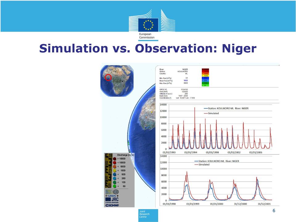
6 Simulation vs. Observation: Niger 6
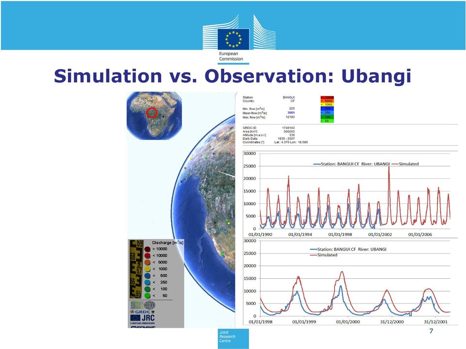
7 Simulation vs. Observation: Ubangi 7
8 Skill score analysis Pierce skill score of simulated versus observed discharge for 620 selected stations 19 February


9 Estimating flood magnitude in GloFAS Era-Interim HTESSEL/Lisflood Simulated discharge time series Q in m 3/s Days Thresholds are derived from simulated time series. The same model set-up and parameterisations are used in the forecasts to remain model consistent Thresholds Q20 Q5 Q2 Q1.3 Return period statistics

10 How does GloFAS work Finding simple ways to communicate complex information Easy and fast access to flood forecast via: Password protected Web Interface Updates every day Easy understandable hotspot maps, flood probability maps, flood threshold exceedance Hydrologically relevant meteo information 19 February

11 GloFAS forecast example 15 July 2011

12 GloFAS and SOS/WaterML: GloFAS forecasts are already published online on a password protected website But: for a better integration into other systems more is needed Providing GloFAS simulation results at points where observed river discharge is available using the international standards for hydrologic information exchange such as WaterML2 and its associated data sharing services we are currently testing to provide. Benefits: Verification of model simulations against observations globally Better integration of GloFAS forecasts into national forecasting services

13 Next steps: Improving GloFAS Meteorological forcing: assess different global meteorological forcings (ERA20C, Princeton's Global Meteorological Forcing Dataset, GPCC, etc.) Hydrological model: improving river network, inclusion of lakes and reservoirs, improve transmission losses, include water use User interface: Create a stand alone user web interface for easy forecast access Web services: Improve accessibility of GloFAS forecasts using WMS and SOS

14 For more information: Paper published in HESS: html Contact: 14

Towards a pan-african Flood Early Warning System: Experiences from the European Flood Alert System (EFAS) and pilot-testing in Africa
 and pilot-testing in Africa") 8th World General Assembly of INBO Adapting to the consequences of climate change in basins: tools for action (Dakar, 20 23 January 2010) Towards a pan-african Flood Early Warning System: Experiences from
8th World General Assembly of INBO Adapting to the consequences of climate change in basins: tools for action (Dakar, 20 23 January 2010) Towards a pan-african Flood Early Warning System: Experiences from
Quality Control, Validation and User Feedback of the European Flood Alert System (EFAS)
") Quality Control, Validation and User Feedback of the European Flood Alert System (EFAS) De Roo, Ad 1 *, Jutta Thielen 1, Peter Salamon 1, Florian Pappenberger 2, Konrad Bogner 1, Sebastien Nobert 3, Hannah
Quality Control, Validation and User Feedback of the European Flood Alert System (EFAS) De Roo, Ad 1 *, Jutta Thielen 1, Peter Salamon 1, Florian Pappenberger 2, Konrad Bogner 1, Sebastien Nobert 3, Hannah
EFAS European Flood Awareness System
 EFAS European Flood Awareness System http://www.efas.eu/ EFAS Partner Network The first operational hydrological network in Europe Cristina Alionte Eklund Coordinator EFAS Dissemination Center History
Emergency Management Service. early warning FLOOD AND FIRE ALERTS. Space
 Emergency Management Service early warning FLOOD AND FIRE ALERTS Space 1 Copernicus at a Glance Copernicus is the European Union s Earth Observation programme: a user-driven space programme under civil
How To Calculate Flood Damage Potential In European Landscape
 Background/Introduction RISK ANALYSIS MODULE 3, CASE STUDY 2 Flood Damage Potential at European Scale By Dr. Peter Burek There is good reason to be concerned about the growth of flood losses in Europe.
Proposals of Summer Placement Programme 2015
 Proposals of Summer Placement Programme 2015 Division Project Title Job description Subject and year of study required A2 Impact of dual-polarization Doppler radar data on Mathematics or short-term related
Flash Flood Guidance Systems
 Flash Flood Guidance Systems Introduction The Flash Flood Guidance System (FFGS) was designed and developed by the Hydrologic Research Center a non-profit public benefit corporation located in of San Diego,
The European Flood Awareness System (EFAS): the management of the Hydrological Data Collection Center and the. experience in Andalusia
: the management of the Hydrological Data Collection Center and the. experience in Andalusia") The European Flood Awareness System (EFAS): the management of the Hydrological Data Collection Center and the The European Flood Awareness System (EFAS): the management of the Hydrological Data Collection
The European Flood Awareness System (EFAS): the management of the Hydrological Data Collection Center and the The European Flood Awareness System (EFAS): the management of the Hydrological Data Collection
GRDC. Global Runoff Data Centre. Facilitator between Runoff Data Providers and Data Users
 GRDC Global Runoff Data Centre Facilitator between Runoff Data Providers and Data Users Second UN-SPIDER Workshop Disaster Management and Space Technology Bridging the Gap 13 15 October 2008 Bonn, Germany
HYDROMETEOROLOGICAL AND MONITORING SERVICE
 Regional Association VI, Forum Hydrology, Koblenz May 8 10, 2012 MINISTRY OF EMERGENCY SITUATIONS OF ARMENIA ARMENIAN STATE HYDROMETEOROLOGICAL AND MONITORING SERVICE Amalya Misakyan THE STRUCTURE OF ARMSTATEHYDROMET
Next generation models at MeteoSwiss: communication challenges
 Federal Department of Home Affairs FDHA Federal Office of Meteorology and Climatology MeteoSwiss Next generation models at MeteoSwiss: communication challenges Tanja Weusthoff, MeteoSwiss Material from
Hong Kong Observatory Summer Placement Programme 2015
 Annex I Hong Kong Observatory Summer Placement Programme 2015 Training Programme : An Observatory mentor with relevant expertise will supervise the students. Training Period : 8 weeks, starting from 8
On the Use of Global Flood Forecasts and Satellite-Derived Inundation Maps for Flood Monitoring in Data-Sparse Regions
 Remote Sens. 2015, 7, 15702-15728; doi:10.3390/rs71115702 Article OPEN ACCESS remote sensing ISSN 2072-4292 www.mdpi.com/journal/remotesensing On the Use of Global Flood Forecasts and Satellite-Derived
CURRENT STATUS OF HYDROLOGICAL DATA MANAGEMENT SYSTEM IN SLOVENIA. Country report. Dr. Mira Kobold
 CURRENT STATUS OF HYDROLOGICAL DATA MANAGEMENT SYSTEM IN SLOVENIA Country report Dr. Mira Kobold Slovenian Environment Agency REPUBLIC OF SLOVENIA SURFACE WATERS NETWORK 186 operating measuring stations
JASPERS Networking Platform
 JASPERS Networking Platform Promoting climate change adaptation, risk prevention and management in the Water Sector UK Emergency Warning System Rachel Brisley, Technical Director & Sophie Dusting, Analyst
Armenian State Hydrometeorological and Monitoring Service
 Armenian State Hydrometeorological and Monitoring Service Offenbach 1 Armenia: IN BRIEF Armenia is located in Southern Caucasus region, bordering with Iran, Azerbaijan, Georgia and Turkey. The total territory
Real-time Global Flood Monitoring and Forecasting using an Enhanced Land Surface Model with Satellite and NWP model based Precipitation
 Real-time Global Flood Monitoring and Forecasting using an Enhanced Land Surface Model with Satellite and NWP model based Precipitation Huan Wu,2, Robert F. Adler, 2, Yudong Tian, 2, George J. Huffman
Baudouin Raoult, Iryna Rozum, Dick Dee
 ECMWF contribution to the EU funded CHARME Project: A Significant Event Viewer tool Matthew Manoussakis Baudouin Raoult, Iryna Rozum, Dick Dee 5th Workshop on the use of GIS/OGC standards in meteorology
Precipitation Monitoring Network:
 The Caribbean Drought and Precipitation Monitoring Network: Adrian R. Trotman Caribbean Institute for Meteorology and Hydrology CARIWIN Regional Seminar 14-15 January, 2010 Georgetown, Guyana Why Plan
Catastrophe Bond Risk Modelling
 Catastrophe Bond Risk Modelling Dr. Paul Rockett Manager, Risk Markets 6 th December 2007 Bringing Science to the Art of Underwriting Agenda Natural Catastrophe Modelling Index Linked Securities Parametric
DESWAT project (Destructive Water Abatement and Control of Water Disasters)
") A new national hydrological forecast and warning system is now in advanced implementation phase, within the Romanian Waters National Administration, in the framework of DESWAT project. The main objectives
A new national hydrological forecast and warning system is now in advanced implementation phase, within the Romanian Waters National Administration, in the framework of DESWAT project. The main objectives
The AIR Inland Flood Model for the United States In Spring 2011, heavy rainfall and snowmelt produced massive flooding along the Mississippi River,
 The AIR Inland Flood Model for the United States In Spring 2011, heavy rainfall and snowmelt produced massive flooding along the Mississippi River, inundating huge swaths of land across seven states. As
Domestic Policy Framework on Adaptation to Climate Change in Water Resources: Case Study for India. Working Together to Respond to Climate Change
 Domestic Policy Framework on Adaptation to Climate Change in Water Resources: Case Study for India Working Together to Respond to Climate Change WATER ACCOUNTING OF INDIA S TOTAL WATER RESOURCES Unutilizable
Application of global 1-degree data sets to simulate runoff from MOPEX experimental river basins
 18 Large Sample Basin Experiments for Hydrological Model Parameterization: Results of the Model Parameter Experiment. IAHS Publ. 37, 26. Application of global 1-degree data sets to simulate from experimental
Estimating Potential Reduction Flood Benefits of Restored Wetlands
 Estimating Potential Reduction Flood Benefits of Restored Wetlands Kenneth W. Potter University of Wisconsin Introduction Throughout the summer of 1993 a recurring question was the impact of wetland drainage
WELCOMES ALL THE ATTENDEES WATER UTILISATION, MEASUREMENT AND METHODOLOGIES
 SUTRON india WELCOMES ALL THE ATTENDEES WATER UTILISATION, MEASUREMENT AND ABOUT SUTRON USA Strong Corporation was founded in 1975 Sutron Operates in : Hydrological Meteorological Oceanic Aviation Real-Time
New challenges of water resources management: Title the future role of CHy
 New challenges of water resources management: Title the future role of CHy by Bruce Stewart* Karl Hofius in his article in this issue of the Bulletin entitled Evolving role of WMO in hydrology and water
DISASTER RISK DETECTION AND MANAGEMENT COURSES SETUP SCENARIO AT MAKERERE UNIVERSITY. Makerere University
 DISASTER RISK DETECTION AND MANAGEMENT COURSES SETUP SCENARIO AT MAKERERE UNIVERSITY CASE OF THE DEPARTMENT OF GEOGRAPHY Derek Muhwezi 2 MISSION OF THE DEPARTMENT To provide and promote quality education,
Nowcasting: analysis and up to 6 hours forecast
 Nowcasting: analysis and up to 6 hours forecast Very high resoultion in time and space Better than NWP Rapid update Application oriented NWP problems for 0 6 forecast: Incomplete physics Resolution space
Application of Numerical Weather Prediction Models for Drought Monitoring. Gregor Gregorič Jožef Roškar Environmental Agency of Slovenia
 Application of Numerical Weather Prediction Models for Drought Monitoring Gregor Gregorič Jožef Roškar Environmental Agency of Slovenia Contents 1. Introduction 2. Numerical Weather Prediction Models -
Transboundary cooperation in the flood forecasting and warning service within the international Morava river basin
 Transboundary cooperation in the flood forecasting and warning service within the international Morava river basin Eva Soukalová Český hydrometeorologický ústav, pobočka Brno eva.soukalova@chmi.cz Morava
NOWCASTING OF PRECIPITATION Isztar Zawadzki* McGill University, Montreal, Canada
 NOWCASTING OF PRECIPITATION Isztar Zawadzki* McGill University, Montreal, Canada 1. INTRODUCTION Short-term methods of precipitation nowcasting range from the simple use of regional numerical forecasts
AZ EGER-PATAK HIDROLÓGIAI VIZSGÁLATA, A FELSZÍNI VÍZKÉSZLETEK VÁRHATÓ VÁLTOZÁSÁBÓL ADÓDÓ MÓDOSULÁSOK AZ ÉGHAJLATVÁLTOZÁS HATÁSÁRA
 AZ EGER-PATAK HIDROLÓGIAI VIZSGÁLATA, A FELSZÍNI VÍZKÉSZLETEK VÁRHATÓ VÁLTOZÁSÁBÓL ADÓDÓ MÓDOSULÁSOK AZ ÉGHAJLATVÁLTOZÁS HATÁSÁRA GÁBOR KEVE 1, GÉZA HAJNAL 2, KATALIN BENE 3, PÉTER TORMA 4 EXTRAPOLATING
Fire Weather Index: from high resolution climatology to Climate Change impact study
 Fire Weather Index: from high resolution climatology to Climate Change impact study International Conference on current knowledge of Climate Change Impacts on Agriculture and Forestry in Europe COST-WMO
Towards an NWP-testbed
 Towards an NWP-testbed Ewan O Connor and Robin Hogan University of Reading, UK Overview Cloud schemes in NWP models are basically the same as in climate models, but easier to evaluate using ARM because:
Global Flood Partnership
 Global Flood Partnership Global tools and services for managing flood risk and emergencies Dr. Tom De Groeve Joint Research Centre of the European Commission tom.de-groeve@jrc.ec.europe.eu State of global
Asia-Pacific Environmental Innovation Strategy (APEIS)
") Asia-Pacific Environmental Innovation Strategy (APEIS) Integrated Environmental Monitoring IEM) Dust Storm Over-cultivation Desertification Urbanization Floods Deforestation Masataka WATANABE, National
Asia-Pacific Environmental Innovation Strategy (APEIS) Integrated Environmental Monitoring IEM) Dust Storm Over-cultivation Desertification Urbanization Floods Deforestation Masataka WATANABE, National
Climate Extremes Research: Recent Findings and New Direc8ons
 Climate Extremes Research: Recent Findings and New Direc8ons Kenneth Kunkel NOAA Cooperative Institute for Climate and Satellites North Carolina State University and National Climatic Data Center h#p://assessment.globalchange.gov
Decision support for urban drainage using radar data of HydroNET-SCOUT
 Weather Radar and Hydrology (Proceedings of a symposium held in Exeter, UK, April 2011) (IAHS Publ. 351, 2011). 1 Decision support for urban drainage using radar data of HydroNET-SCOUT ARNOLD LOBBRECHT
Advanced tools in water management in The Netherlands
 Advanced tools in water management in The Netherlands Modelling for system knowledge, effective operational management, and policy making Gé van den Eertwegh Rivierenland Water Board The Netherlands PR
Capabilities, limitations and new horizons of Fibreoptic Distributed Temperature Sensing in. ecohydrological and hydrogeological research
 Capabilities, limitations and new horizons of Fibreoptic Distributed Temperature Sensing in ecohydrological and hydrogeological research Stefan Krause University of Birmingham, School for s, Birmingham,
AMESD/MESA & GMES and Africa
 AMESD/MESA & GMES and Africa Jolly Wasambo AUC-REA Outline Background MESA: objective and expected results Thematic actions & services Some concerns about natural resources Land degradation Loss of soil
River Flood Damage Assessment using IKONOS images, Segmentation Algorithms & Flood Simulation Models
 River Flood Damage Assessment using IKONOS images, Segmentation Algorithms & Flood Simulation Models Steven M. de Jong & Raymond Sluiter Utrecht University Corné van der Sande Netherlands Earth Observation
The Wind Integration National Dataset (WIND) toolkit
 toolkit") The Wind Integration National Dataset (WIND) toolkit EWEA Wind Power Forecasting Workshop, Rotterdam December 3, 2013 Caroline Draxl NREL/PR-5000-60977 NREL is a national laboratory of the U.S. Department
The Wind Integration National Dataset (WIND) toolkit EWEA Wind Power Forecasting Workshop, Rotterdam December 3, 2013 Caroline Draxl NREL/PR-5000-60977 NREL is a national laboratory of the U.S. Department
My presentation will be on rainfall forecast alarms for high priority rapid response catchments.
 Hello everyone My presentation will be on rainfall forecast alarms for high priority rapid response catchments. My name is Oliver Pollard. I have over 20 years hydrological experience with the Environment
Hydrologic Modeling using HEC-HMS
 Hydrologic Modeling using HEC-HMS Prepared by Venkatesh Merwade School of Civil Engineering, Purdue University vmerwade@purdue.edu April 2012 Introduction The intent of this exercise is to introduce you
A GLOBAL DATA EXCHANGE PERSPECTIVE
 A GLOBAL DATA EXCHANGE PERSPECTIVE Data exchange (Availability and quality) Policy Technology Dissemination Experts and forecasters End users WMO Data Exchange Policy Committed to broadening and enhancing,
Global Flood Alert System (GFAS)
") An Introduction of Global Flood Alert System (GFAS) Kazuo UMEDA Director of 2 nd Research Department, Infrastructure Development Institute-JAPAN Target: Reduction of Human Loss World s s natural disaster
An Introduction of Global Flood Alert System (GFAS) Kazuo UMEDA Director of 2 nd Research Department, Infrastructure Development Institute-JAPAN Target: Reduction of Human Loss World s s natural disaster
Presentation from 2015 World Water Week in Stockholm. www.worldwaterweek.org. The authors, all rights reserved. SIWI siwi.org
 Presentation from 2015 World Water Week in Stockholm www.worldwaterweek.org The authors, all rights reserved SIWI siwi.org Abdulkarim Seid NBI Secretariat Stockholm, 25 Aug 2015 The Nile Basin Decision
Titelmasterformat durch Klicken. bearbeiten
 Evaluation of a Fully Coupled Atmospheric Hydrological Modeling System for the Sissili Watershed in the West African Sudanian Savannah Titelmasterformat durch Klicken June, 11, 2014 1 st European Fully
River Flooding and the Grid-to-Grid Hydrological Model
 River Flooding and the Grid-to-Grid Hydrological Model Summary of Impacts Impact Mitigating the annual costs of damage from ordinary river flooding Mitigating the costs of damage from extreme river flooding
Data Management Model. Potential Component of the Thames River Water Management Plan
 WISKI Water Quality / Quantity Data Management Model Potential Component of the Thames River Water Management Plan Background Goal of the Thames River Water Management Plan: Improve water quality of the
Drought Monitoring and Forecasting in Sub-Saharan African. Justin Sheffield Princeton University
 Drought Monitoring and Forecasting in Sub-Saharan African Justin Sheffield Princeton University Outline Challenges for sub-saharan Africa (SSA) Current capabilities (national, regional, international) Princeton
WATER QUALITY MONITORING AND APPLICATION OF HYDROLOGICAL MODELING TOOLS AT A WASTEWATER IRRIGATION SITE IN NAM DINH, VIETNAM
 WATER QUALITY MONITORING AND APPLICATION OF HYDROLOGICAL MODELING TOOLS AT A WASTEWATER IRRIGATION SITE IN NAM DINH, VIETNAM LeifBasherg (1) OlujZejlllJul Jessen (1) INTRODUCTION The current paper is the
Preliminary advances in Climate Risk Management in China Meteorological Administration
 Preliminary advances in Climate Risk Management in China Meteorological Administration Gao Ge Guayaquil,Ecuador, Oct.2011 Contents China Framework of Climate Service Experience in Climate/disaster risk
Standardized Runoff Index (SRI)
") Standardized Runoff Index (SRI) Adolfo Mérida Abril Javier Gras Treviño Contents 1. About the SRI SRI in the world Methodology 2. Comments made in Athens on SRI factsheet 3. Last modifications of the factsheet
Standardized Runoff Index (SRI) Adolfo Mérida Abril Javier Gras Treviño Contents 1. About the SRI SRI in the world Methodology 2. Comments made in Athens on SRI factsheet 3. Last modifications of the factsheet
Hydrologic Engineering Techniques for Regional Water Resources Planning
 US Army Corps of Engineers Hydrologic Engineering Center Hydrologic Engineering Techniques for Regional Water Resources Planning October 1969 Approved for Public Release. Distribution Unlimited. TP-17
Basic system of measures for flood damage mitigation in Japan. Preparedness for major floods
 Basic system of measures for flood damage mitigation in Japan Preparedness for major floods Past major floods and state-level efforts Role of the 2 MLIT's disaster prevention efforts Disaster prevention
Methods for Determination of Safe Yield and Compensation Water from Storage Reservoirs
 US Army Corps of Engineers Hydrologic Engineering Center Methods for Determination of Safe Yield and Compensation Water from Storage Reservoirs October 1966 Approved for Public Release. Distribution Unlimited.
Basic Climatological Station Metadata Current status. Metadata compiled: 30 JAN 2008. Synoptic Network, Reference Climate Stations
 Station: CAPE OTWAY LIGHTHOUSE Bureau of Meteorology station number: Bureau of Meteorology district name: West Coast State: VIC World Meteorological Organization number: Identification: YCTY Basic Climatological
HAZARD RISK ASSESSMENT, MONITORING, MAINTENANCE AND MANAGEMENT SYSTEM (HAMMS) FOR LANDSLIDE AND FLOOD. Mohd. Nor Desa, Rohayu and Lariyah, UNITEN
 FOR LANDSLIDE AND FLOOD. Mohd. Nor Desa, Rohayu and Lariyah, UNITEN") HAZARD RISK ASSESSMENT, MONITORING, MAINTENANCE AND MANAGEMENT SYSTEM (HAMMS) FOR LANDSLIDE AND FLOOD Mohd. Nor Desa, Rohayu and Lariyah, UNITEN WHAT WE HAVE IN MIND AND FROM OUR PREVIOUS PROJECT CONTRIBUTION
HAZARD RISK ASSESSMENT, MONITORING, MAINTENANCE AND MANAGEMENT SYSTEM (HAMMS) FOR LANDSLIDE AND FLOOD Mohd. Nor Desa, Rohayu and Lariyah, UNITEN WHAT WE HAVE IN MIND AND FROM OUR PREVIOUS PROJECT CONTRIBUTION
National Dam Safety Program Technical Seminar #22. When is Flood Inundation Mapping Not Applicable for Forecasting
 National Dam Safety Program Technical Seminar #22 Thursday February 19 th 2015 Emmittsburg, MD When is Flood Inundation Mapping Not Applicable for Forecasting Victor Hom Hydrologic Services Division National
Environmental Data Management Programs
 Hydrologic Engineering Centre (HEC) Software CD Collection of programs, developed by the U.S. Army Corps of Engineers Environmental Data Management Programs Name: HEC-DSS Package Purpose: Data Storage
Abaya-Chamo Lakes Physical and Water Resources Characteristics, including Scenarios and Impacts
 LARS 2007 Catchment and Lake Research Abaya-Chamo Lakes Physical and Water Resources Characteristics, including Scenarios and Impacts Seleshi Bekele Awulachew International Water Management Institute Introduction
Innovative E-Government Best Practices in Early Warning System for Disaster Risk Management: Bangladesh Experience
 Innovative E-Government Best Practices in Early Warning System for Disaster Risk Management: Bangladesh Experience Dilder Ahmed (Joint Secretary) Project Director ECRRP-D-1 Department of Disaster Management.
Validation n 2 of the Wind Data Generator (WDG) software performance. Comparison with measured mast data - Flat site in Northern France
 software performance. Comparison with measured mast data - Flat site in Northern France") Validation n 2 of the Wind Data Generator (WDG) software performance Comparison with measured mast data - Flat site in Northern France Mr. Tristan Fabre* La Compagnie du Vent, GDF-SUEZ, Montpellier, 34967,
Validation n 2 of the Wind Data Generator (WDG) software performance Comparison with measured mast data - Flat site in Northern France Mr. Tristan Fabre* La Compagnie du Vent, GDF-SUEZ, Montpellier, 34967,
Track-Risk-Impact-Policy (TRIP) Modeling for the Agricultural Sector
 Modeling for the Agricultural Sector") Track-Risk-Impact-Policy (TRIP) Modeling for the Agricultural Sector Glenn S. Banaguas Environmental and Climate Change Research Institute De La Salle Araneta University Manila Observatory Ateneo De Manila
Track-Risk-Impact-Policy (TRIP) Modeling for the Agricultural Sector Glenn S. Banaguas Environmental and Climate Change Research Institute De La Salle Araneta University Manila Observatory Ateneo De Manila
Finnish Meteorological Institute s Services for Insurance Sector
 Finnish Meteorological Institute s Services for Insurance Sector Regional training workshop Role of the NMHSs in support of DRR- related activities in the field of insurance Janne Miettinen, Account Manager,
National Weather Service Flash Flood Modeling and Warning Services
 National Weather Service Flash Flood Modeling and Warning Services Seann Reed, Middle Atlantic River Forecast Center Peter Ahnert, Middle Atlantic River Forecast Center August 23, 2012 USACE Flood Risk
INSTALLATION OF AN AUTOMATED EARLY WARNING SYSTEM FOR ANNOTTO BAY
 TERMS OF REFERENCE INSTALLATION OF AN AUTOMATED EARLY WARNING SYSTEM FOR ANNOTTO BAY A Community Disaster Risk Reduction Project funded through the Building Disaster Resilient Communities Project (ODPEM)
Pan-European flood hazard and damage assessment; evaluation of a new If-SAR Digital Terrain Model for flood depth and flood extent calculation
 Pan-European flood hazard and damage assessment; evaluation of a new If-SAR Digital Terrain Model for flood depth and flood extent calculation Marco Rusmini March, 2009 Pan-European flood hazard and damage
03 STRATEGIC REVIEW OF OPTIONS FOR FLOOD FORECASTING AND WARNING IN IRELAND
 03 STRATEGIC REVIEW OF OPTIONS FOR FLOOD FORECASTING AND WARNING IN IRELAND Jeremy 1, Sarah Conroy 1, Brian Golding 2, 1. JBA Consulting, Limerick 2. UK Meteorological Office Abstract JBA Consulting and
DoD Interest in Seasonal & Sub-seasonal Climate Prediction
 DoD Interest in Seasonal & Sub-seasonal Climate Prediction Maj Ryan Harris Director of Operations 14th Weather Squadron Asheville, NC Approved for Public Release Distribution Unlimited 31 March 2015 Overview
Flood early warning systems improve preparedness
 Flood early warning systems improve preparedness March 31, 2015 Ad Jeuken, Simone van Schijndel Deltares Content Early warning systems Delft FEWS Purpose, characteristics Elements Example application Benefits
PRECIPITATION AND EVAPORATION
 PRECIPITATION AND EVAPORATION OBJECTIVES Use historical data to analyze relationships between precipitation, evaporation and stream flow in the San Antonio River Basin TOPICS Water cycle Precipitation
CEOS Water Portal Status Update
 CEOS Water Portal Status Update WGISS-33 Tokyo, Japan April 23-27, 2012 JAXA/Mission Operations System Office Satoko Miura/ Atsushi Kawai Update since WGISS-32 New features Compare service for MOLTS data
Lars-Göran Gustafsson, DHI Water and Environment, Box 3287, S-350 53 Växjö, Sweden
 Alternative Drainage Schemes for Reduction of Inflow/Infiltration - Prediction and Follow-Up of Effects with the Aid of an Integrated Sewer/Aquifer Model Introduction Lars-Göran Gustafsson, DHI Water and
Cloud Model Verification at the Air Force Weather Agency
 2d Weather Group Cloud Model Verification at the Air Force Weather Agency Matthew Sittel UCAR Visiting Scientist Air Force Weather Agency Offutt AFB, NE Template: 28 Feb 06 Overview Cloud Models Ground
Real-time hazard impact modelling for surface water flooding: some UK developments
 Real-time hazard impact modelling for surface water flooding: some UK developments Steven Cole 1, Bob Moore 1, Timothy Aldridge 2, Andy Lane 3,4 and Stefan Laeger 4 International Conference on Flood Resilience,
REQUIREMENTS FOR WEATHER RADAR DATA
 WORLD METEOROLOGICAL ORGANIZATION COMMISSION FOR BASIC SYSTEMS OPEN PROGRAMME AREA GROUP ON INTEGRATED OBSERVING SYSTEMS WORKSHOP ON RADAR DATA EXCHANGE EXETER, UK, 24-26 APRIL 2013 CBS/OPAG-IOS/WxR_EXCHANGE/2.4
A Conceptual Framework for the National Flood Interoperability Experiment 1
 A Conceptual Framework for the National Flood Interoperability Experiment 1 By David R. Maidment Center for Research in Water Resources University of Texas at Austin Revised, 9 February 2015 Summary The
Catchment and Lake Research
 LARS 2007 Catchment and Lake Research Flood Forecasting and Early Warning System (FFEWS) an Alternative Technology for Flood Management System and Damage Reduction in Ethiopia: A Concept Note Semu Ayalew
Disaster Recovery And Contingency Plan Design and Implementation Manual For Utilities
 Disaster Recovery And Contingency Plan Design and Implementation Manual For Utilities Depend on Our People. Count on Our Advice. SM Member TELERGEE Alliance DISASTER RECOVERY AND CONTINGENCY PLAN DESIGN
Elbe flood in 2002 and 2006 in terms of emergency management
 Elbe flood in 2002 and 2006 in terms of emergency management Ing. Jaroslav Pikal, Regional Authority of the Usti Region 10 Years of Transnational Cooperation in Flood Risk Management at the LABe ELbe Saxon
EU China River Basin Management Programme
 Ministry of Water Resources Ministry of Environmental Protection EU China River Basin Management Programme Technical Report 075 Water Resource Supply Security Strategy Analysis Ben Piper, Zhang Wang and
Eastern Caribbean Open-Source Geospatial Data Sharing and Management Workshop
 Eastern Caribbean Open-Source Geospatial Data Sharing and Management Workshop Data Collection and Management in the Caribbean Spice Island Resort, St. George s, Grenada October 6 7, 2011 Presented by:
Web applications update
 Web applications update Current status, recent developments and future plans Cihan Sahin On behalf of Web development team cihan.sahin@ecmwf.int ECMWF June 7, 2016 Web applications ECMWF has a suite of
 Disaster Prevention Measures in Global-Local Context 4 th World Water Forum Dr. Yoshihiko Yamashita CTI Engineering Co., Ltd Association of Japanese Consulting Engineers Outline of Presentation Up-to to-date
Latin American and Caribbean Flood and Drought Monitor Tutorial Last Updated: November 2014
 Latin American and Caribbean Flood and Drought Monitor Tutorial Last Updated: November 2014 Introduction: This tutorial examines the main features of the Latin American and Caribbean Flood and Drought
Probabilistic forecast information optimised to end-users applications: three diverse examples
 Probabilistic forecast information optimised to end-users applications: three diverse examples ECMWF User Seminar 2015 Vanessa Stauch, Renate Hagedorn, Isabel Alberts, Reik Schaab Our group Land Transport
Real-time modelling of surface water flooding hazard and impact at countrywide scales
 Real-time modelling of surface water flooding hazard and impact at countrywide scales Steven Cole 1, Robert Moore 1, Paul Mattingley 1,Timothy Aldridge 2, Jon Millard 3,4 and Stefan Laeger 5 BHS National
REQUEST FOR A SPECIAL PROJECT 2016 2018
 REQUEST FOR A SPECIAL PROJECT 2016 2018 MEMBER STATE: Germany Principal Investigator 1 : Affiliation: Address: Stefan Kollet Forschungszentrum Jülich, Agrosphere (IBG-3) Wilhelm-Johnen-Straße 52425 Jülich
A Project to Create Bias-Corrected Marine Climate Observations from ICOADS
 A Project to Create Bias-Corrected Marine Climate Observations from ICOADS Shawn R. Smith 1, Mark A. Bourassa 1, Scott Woodruff 2, Steve Worley 3, Elizabeth Kent 4, Simon Josey 4, Nick Rayner 5, and Richard
International Data Centre for Hydrology of Lakes and Reservoirs (HYDROLARE)
") Sengupta, M. and Dalwani, R. (Editors). 2008 Proceedings of Taal 2007: The 12th World Lake Conference: 2258-2262 International Data Centre for Hydrology of Lakes and Reservoirs (HYDROLARE) T.P. Gronskaya,
Sengupta, M. and Dalwani, R. (Editors). 2008 Proceedings of Taal 2007: The 12th World Lake Conference: 2258-2262 International Data Centre for Hydrology of Lakes and Reservoirs (HYDROLARE) T.P. Gronskaya,
POTENTIAL IMPACTS OF CLIMATE CHANGE ON FLOODING IN WISCONSIN
 POTENTIAL IMPACTS OF CLIMATE CHANGE ON FLOODING IN WISCONSIN Ken Potter and Zach Schuster Department of Civil & Environmental Engineering University of Wisconsin Madison, WI OUTLINE Typical flood scenarios
2015 Global Risk Assessment. Sahar Safaie Program Officer, UNISDR Risk Knowledge Section
 2015 Global Risk Assessment Sahar Safaie Program Officer, UNISDR Risk Knowledge Section Outline Global Assessment Report (GAR) evolution Global Risk Assessment for GAR15 Objective Scope Audience/Users
7.10 INCORPORATING HYDROCLIMATIC VARIABILITY IN RESERVOIR MANAGEMENT AT FOLSOM LAKE, CALIFORNIA
 7.10 INCORPORATING HYDROCLIMATIC VARIABILITY IN RESERVOIR MANAGEMENT AT FOLSOM LAKE, CALIFORNIA Theresa M. Carpenter 1, Konstantine P. Georgakakos 1,2, Nicholas E. Graham 1,2, Aris P. Georgakakos 3,4,
Multi-Hazard Disaster Risk Assessment (v2)
") Multi-Hazard Disaster Risk Assessment (v2) This How to Note is part of a series of Guidance Notes designed to assist DFID Country Offices in embedding disaster resilience in their country programmes. This
Multi-Hazard Disaster Risk Assessment (v2) This How to Note is part of a series of Guidance Notes designed to assist DFID Country Offices in embedding disaster resilience in their country programmes. This
Real-time Ocean Forecasting Needs at NCEP National Weather Service
 Real-time Ocean Forecasting Needs at NCEP National Weather Service D.B. Rao NCEP Environmental Modeling Center December, 2005 HYCOM Annual Meeting, Miami, FL COMMERCE ENVIRONMENT STATE/LOCAL PLANNING HEALTH
National Oceanography Centre. Research & Consultancy Report No. 26
 National Oceanography Centre Research & Consultancy Report No. 26 Re-analysis of the December 1981 storm surge event in the Bristol Channel using the current operational tide-surge model suite J Williams,