RECENT AND CURRENT ACTIVITIES OF THE TCWC Port Moresby. SIXTH TROPICAL CYCLONE RSMCs/TCWCs TECHNICAL COORDINATION MEETING BRISBANE, AUSTRALIA
|
|
|
- Emily Fitzgerald
- 7 years ago
- Views:
Transcription
1 RECENT AND CURRENT ACTIVITIES OF THE TCWC Port Moresby SIXTH TROPICAL CYCLONE RSMCs/TCWCs TECHNICAL COORDINATION MEETING BRISBANE, AUSTRALIA 2 TO 5 NOVEMBER 2009 Presented by Mr. Jimmy GOMOGA ASSISTANT DIRECTOR MANAGER: FORECASTING & WARNING CENTRE PNG NATIONAL WEATHER SERVICE PH: FAX: Mobile: jgomoga@pngmet.gov.pg

2 Introduction Area of responsibly Monitoring Role in the Tropics Port Moresby TCWC Role Tropical Cyclone Season 2005/ /09 High seas forecasts and warnings Non Meteorological Information Training & Research

3 Port Moresby Forecasting Centre
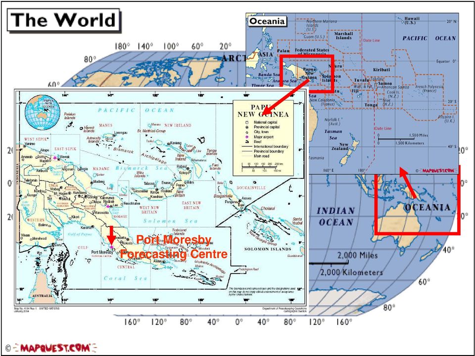
4 Area of Responsibly Port Moresby TCWC Port Moresby is designated as a TCWC with geographic specialization area of responsibly bounded by the EQ 141E, 10S 141E, 09S 144E, 12S 147E, 12S 155E, 08S 155E, 05S 160E, EQ 160E, EQ 141E.

5 ROLE OF FORECASTING & WARNING CENTRE PUBLIC & SEVERE WEATHER (REAL TIME MONITORING & ANALYSIS) (NOWCASTING 0-1 DAY, MID-RANGE 1-5 DAYS & LONG RANGE >5 DAYS) AVIATION WEATHER TROPICAL CYCLONE TRACKING & FORECASTING

6 Forecasting Tools Available Satellite Images Available Numerical Models Near real time observations from satellites RANET, EMWIN, LRIT (Microwave prod.) Real time observations from Observations network SATAID, Dvorak Internet based Models, NOGAPS, JTWC, BOM, ECMWF, UK MET
 Real time observations from Observations network SATAID, Dvorak")
7 TECHNIQUES AND DATA USED OPERATIONALLY DVORAK TECHNIQUE BUT MANUAL NOT MANY YOUNG FORECASTERS ARE FAMILIAR WITH IT. Use satellite and internet communication a real time weather data is downloaded and analysis to write daily weather forecasts and issue of severe weather and TC warnings. Disseminated to users and general public via and fax communication which are then aired by the local media stations.

8 Inter-Tropical Convergence Zone (ITCZ) 1998 Prentice-Hall, Inc. ITCZ -- Moves south in January

9 Inter-Tropical Convergence Zone (ITCZ) 1998 Prentice-Hall, Inc. ITCZ -- Moves north in July

10 Tropical Cyclone Season Annually, from 1 November to 31 May, Port Moresby produces a daily Tropical Cyclone Potential Bulletin for National Disaster Centre (NDC) to keep them abreast of the latest expectations of cyclone activity in the South Pacific and to help them with their disaster relief planning. Additional advisories are also provided as necessary during the life of a tropical cyclone to fill any information gaps. During this same period, a routine weekly forecaster-to-forecaster conference call is carried out between Brisbane TCWC and Port Moresby forecasters to discuss the situation and developments over the next few days. Port Moresby also provided forecasting advice to NDC for disastrous earthquakes and Tsunamis.

11 Seasonal & Monthly Variation of Tropical Cyclones Tropical Cyclones On the average, PNG receives one tropical cyclone a season Many of these have occurred in Jan/ February 2002: TC Upia late in the season, May - June 2007: TC Guba early in the season, Nov

12
13 Tropical Cyclone Products TC Warnings Strong Wind Warnings Track & Treat Maps issued by BOM & JTWC Satellite images.

14

15 Samples of TC WARNING TC ADVISORIES UP TO 48 HRS. WARNINGS ON TROPICAL CYCLONES AND STORM SURGES 24HRS every 6 HRS TSUNAMIS, TIDAL, ADVISORIES OR PRESS RELEASES

16 TIME SERIES & TEMP PROFILE

17 NWS and Disaster Office Disaster Office manages disasters NWS provide technical advice on meteorologically related disasters NWS issue warnings before disasters, bulletins during disasters and conduct post mortem/assessments after disasters

18 Cont After the disaster, officials visit the affected areas and make assessments on the scale of damage/loss and make recommendations for future improvements

19 seasons from 2005/2006 to 2008/2009, In the 4 seasons from 2005/2006 to 2008/2009, 4 out of the 10 tropical depressions that formed in the Coral and Solomon Seas-South Pacific became tropical cyclones and crossed into the Port Moresby area of responsibility. Of these, Ingrid a small intense cyclone formed on 6 th March 2005 as a weak depression in the western Coral Seas and tracked east and become a tropical cyclone. Large sea swells generated by Ingrid were felt along the southern coasts of Papua New Guinea. On 16 April a tropical low developed just to the east of Papua New Guinea, and began to drift southwest into the Coral Sea. It developed into a tropical cyclone on 17 April, and took a more easterly track towards the north Queensland coast. TC Monica continued to develop as it approached Queensland, and crossed the coast just to the south of Lockhart River, as a Category 3 cyclone, on the afternoon of 19 April. TC Kate formed as a Tropical Depression on the 22 February 2006, rreached Category 2 on the 23rd February and slipped into the Papua New Guinea waters later that afternoon. TC Piere formed as a tropical depression in the south eastern Solomon Seas on the 15 th May 2006 and tracked west into PNG. It developed into a category 1 on the 17 th May and made landfall on the 19 th May. There were no casualties. Guba formed on November 13, 2007 in the northern Solomon Sea, close to the island of New Britain, and reached tropical cyclone intensity the next day by the Tropical Cyclone Warning Centre (TCWC) in Brisbane, with the TCWC in Port Moresby assigning the name Guba. It meandered in the northern Coral Sea for the next week, strengthening to a Category 3 severe tropical cyclone on November 16. It posed a threat to the Australian Cape York Peninsula, but remained offshore, and finally dissipated on November 20. Guba was a classical example of the split system due to the mountain (Owen Stanley range) barrier. TC Guba was in the Coral Sea and not over Oro, however, due to the maintain range barrier, a large cloud build was observed to the north eastern sector and was over Oro Province for 3-4 days and caused the flooding there. Flooding in Papua New Guinea led to at least 200 deaths. In the Oro Province, about 2,000 people were evacuated as a result of the flooding. Roads, bridges and 40 houses were washed away, as tides in the area reached two metres high. In the provincial capital, Popondetta, the water supply and electrical infrastructure was damaged, and road access was blocked. Papua New Guinea's national airline, Air Niugini, suspended flights to Popondetta's main airport. The Rabaraba district in Milne Bay Province was also hit by flooding, with 30 houses and food gardens washed away, and forcing the evacuation of about 100 people. The government in Papua New Guinea reported that an estimated 145,000 people were affected from the flooding in Oro Province. Six days of torrential rain led to a damage total of 200 million kina ($71.4 million USD). The torrential rain was the worst seen in the region in 30 years, according to the local people.

20 Meteorological Satellites, CONT

21 Research & Training Importantly, PNG National Weather Service is primarily focused on operational forecasting, and the research and development work undertaken is focused in the area of improving tools, knowledge and skills of forecasters, and the quality and efficiency of the output. Port Moresby conducts annual mentoring workshops for forecasters and pre seasonal briefings in preparation for the coming cyclone season. The input to these workshops and briefings has been given added value with the help of very experienced forecasters from Brisbane TCWC who have had vast experience in forecasting and tracking of tropical cyclones. WMO, Pacific Desk in Hawaii US, JICA, Meteo-France, Generic BOM Training.
22 Biblical El Nino Years Vs Observed El Nino Years Biblical Predictions Observed Events Remarks 1899/ /1901 Exact 1913/ /1915 Exact 1927/ /1926 Occurred 1 year before predictions 1941/ /1942 Exact 1955/ /1958 After 1 year 1969/ /1970 Exact 1983/ /1983 Exact 1997/ /1998 Exact 2011/2012???? 2025/2026???? 2039/2040????
23 Biblical La Nina Years Vs Observed La Nina Years Biblical Predictions Observed Events Remarks 1906/ /1907 Exact 1920/ /1921 Exact 1934/ / years before predictions 1948/ /1950 Exact 1962/ / year after 1976/ /1976 Exact 1990/ / year before 2004/ /2006 Exact 2018/2019???? 2032/2033???? 2046/2047????
24
25 EL Nino/ La Nina Closer Look 7 years of Drought 7 years of Plenty
26 Port Moresby TC March 2005
27
28
29
30
31 TC Kate February 2006 Tropical Cyclone Kate formed as a Tropical Depression at UTC Reached Category 2 at UTC on Monday 23rd February Slipped into the Papua New Guinea waters at UTC on Monday 23rd February 2006.
32 TC Kate Track Track of Tropical Cyclone Kate Date/ Time (UTC) Position Central Pressure (hpa) Category Distance from nearest town Latitude Longitude (km) Feb S E 1002 TD (Daru) Feb l S E 1000 TD (Daru) Feb S E 1000 TD (Daru) Feb l S E (Port Moresby) Feb S E (Port Moresby) Feb S E (Port Moresby) Feb S E (Port Moresby) Feb S E (Port Moresby) Feb S E 1000 Ex TC (Port Moresby) Feb S E 1001 Ex TC (Port Moresby)
33 91H GHz image of Kate near peak intensity at 2248UTC 22 February 2006 (left) and 81H at 1045UTC showing exposed low level circulation well to the west of the deep convection.
34
35
36
37
38
39 TC ANALYSIS Kate formed very close to the boarder of Australia and Papua New Guinea and tracked eastward eventually crossed into its area of responsibility as Category 2. Much of the area of strong and gale winds remained on the southwest of the centre of TC Kate and therefore only strong winds were felt along the southern coast line of Papua New Guinea. However, following lesions can be learnt from Kate; 1. Weakening was due to differential steering between 850 hpa and 500 hpa levels. 2. Differential steering currents at low and mid levels brought about the position of the low level centre well west of the deep convection. 3. Warm air advection wrapped around the eastern side as did the convection, thereby strengthening and weakening the system. 4. Near border formation and dissipation of Kate was quiet difficult on when to issue a cyclone watch and handover responsibilities so it was jointly monitored.
40 Tropical Cyclone GUBA, Nov 2007
41 Flooding in Papua New Guinea led to at least 200 deaths. In the Oro Province, about 2,000 people were evacuated as a result of the flooding. Roads, bridges and 40 houses were washed away, as tides in the area reached two metres high. In the provincial capital, Popondetta, the water supply and electrical infrastructure was damaged, and road access was blocked. Papua New Guinea's national airline, Air Niugini, suspended flights to Popondetta's main airport. The Rabaraba district in Milne Bay Province was also hit by flooding, with 30 houses and food gardens washed away, and forcing the evacuation of about 100 people. The government in Papua New Guinea reported that an estimated 145,000 people were affected from the flooding in Oro Province. Six days of torrential rain led to a damage total of 200 million kina ($71.4 million USD). The torrential rain was the worst seen in the region in 30 years, according to the local people.
42
43 Current & Future Improvements 2007/ 08: Installation of new Forecaster Workstations 2009: Installation of LIRT System & Digital Atmosphere Future: Upgrade of Forecasting Tools Manual to Semi/ automated Forecasting workstations
44 THANK YOU ALL
Tropical Cyclogenesis Monitoring at RSMC Tokyo Mikio, Ueno Forecaster, Tokyo Typhoon Center Japan Meteorological Agency (JMA)
") JMA/WMO Workshop on Effective Tropical Cyclone Warning in Southeast Asia 11 14 March, 2014 Tropical Cyclogenesis Monitoring at RSMC Tokyo Mikio, Ueno Forecaster, Tokyo Typhoon Center Japan Meteorological
JMA/WMO Workshop on Effective Tropical Cyclone Warning in Southeast Asia 11 14 March, 2014 Tropical Cyclogenesis Monitoring at RSMC Tokyo Mikio, Ueno Forecaster, Tokyo Typhoon Center Japan Meteorological
Disaster Risk Reduction through people centered National Multi-hazard Early Warning System in the context of Maldives
 Disaster Risk Reduction through people centered National Multi-hazard Early Warning System in the context of Maldives Abdul Muhusin, Deputy Director Department of Meteorology, Maldives Fourth Technical
PACIFIC CATASTROPHE RISK ASSESSMENT AND FINANCING INITIATIVE
 PACIFIC CATASTROPHE RISK ASSESSMENT AND FINANCING INITIATIVE NIUE SEPTEMBER 11 COUNTRY RISK PROFILE: NIUE Niue is expected to incur, on average,.9 million USD per year in losses due to earthquakes and
Head 168 HONG KONG OBSERVATORY
 Controlling officer: the Director of the Hong Kong Observatory will account for expenditure under this Head. Estimate... $203.4m Establishment ceiling (notional annual mid-point salary value) representing
Cyclone Testing Station Preliminary Damage Report Tropical Cyclone Olwyn, WA, Australia March 11-14 th, 2015
 Cyclone Testing Station Preliminary Damage Report Tropical Cyclone Olwyn, WA, Australia March 11-14 th, 2015 (Reference: Perth Weather Live) Daniel J. Smith, Ph.D. daniel.smith8@jcu.edu.au Geoff Boughton,
MEDIA RELEASE No.4 SEVERE TROPICAL CYCLONE ULA AND TROPICAL DEPRESSION 07F A TROPICAL CYCLONE ALERT IS NOW INFORCE FOR THE LAU GROUP.
 MEDIA RELEASE No.4 SEVERE TROPICAL CYCLONE ULA AND TROPICAL DEPRESSION 07F 4pm Friday 01 st January 2016 A TROPICAL CYCLONE ALERT IS NOW INFORCE FOR THE LAU GROUP. At 1pm today, Severe Tropical Cyclone
Hurricanes. Characteristics of a Hurricane
 Hurricanes Readings: A&B Ch. 12 Topics 1. Characteristics 2. Location 3. Structure 4. Development a. Tropical Disturbance b. Tropical Depression c. Tropical Storm d. Hurricane e. Influences f. Path g.
IGAD CLIMATE PREDICTION AND APPLICATION CENTRE
 IGAD CLIMATE PREDICTION AND APPLICATION CENTRE CLIMATE WATCH REF: ICPAC/CW/No.32 May 2016 EL NIÑO STATUS OVER EASTERN EQUATORIAL OCEAN REGION AND POTENTIAL IMPACTS OVER THE GREATER HORN OF FRICA DURING
Heavy Rainfall from Hurricane Connie August 1955 By Michael Kozar and Richard Grumm National Weather Service, State College, PA 16803
 Heavy Rainfall from Hurricane Connie August 1955 By Michael Kozar and Richard Grumm National Weather Service, State College, PA 16803 1. Introduction Hurricane Connie became the first hurricane of the
Tropical Cyclone Report Hurricane Fausto (EP072008) 16-22 July 2008. John L. Beven II National Hurricane Center 19 November 2008
 16-22 July 2008. John L. Beven II National Hurricane Center 19 November 2008") Tropical Cyclone Report Hurricane Fausto (EP072008) 16-22 July 2008 John L. Beven II National Hurricane Center 19 November 2008 Fausto was a category 1 hurricane on the Saffir-Simpson Hurricane Scale that
Tropical Cyclone Report Hurricane Fausto (EP072008) 16-22 July 2008 John L. Beven II National Hurricane Center 19 November 2008 Fausto was a category 1 hurricane on the Saffir-Simpson Hurricane Scale that
Department of Commerce National Oceanic & Atmospheric Administration National Weather Service
 Department of Commerce National Oceanic & Atmospheric Administration National Weather Service NATIONAL WEATHER SERVICE WESTERN REGION SUPPLEMENT 17-2003 APPLICABLE TO NWSI 10-701 MARCH 16, 2015 Operations
Monsoon Variability and Extreme Weather Events
 Monsoon Variability and Extreme Weather Events M Rajeevan National Climate Centre India Meteorological Department Pune 411 005 rajeevan@imdpune.gov.in Outline of the presentation Monsoon rainfall Variability
The IPCC Special Report on Managing the Risks of Extreme Events and Disasters to Advance Climate Change Adaptation
 The IPCC Special Report on Managing the Risks of Extreme Events and Disasters to Advance Climate Change Adaptation A changing climate leads to changes in extreme weather and climate events 2 How do changes
Basic Climatological Station Metadata Current status. Metadata compiled: 30 JAN 2008. Synoptic Network, Reference Climate Stations
 Station: CAPE OTWAY LIGHTHOUSE Bureau of Meteorology station number: Bureau of Meteorology district name: West Coast State: VIC World Meteorological Organization number: Identification: YCTY Basic Climatological
1 In this report, "tropical cyclone (TC)" is used as a generic term that includes "low pressure area (LPA)", "tropical depression
 is used as a generic term that includes low pressure area (LPA), tropical depression") Comparative Study on Organized Convective Cloud Systems detected through Early Stage Dvorak Analysis and Tropical Cyclones in Early Developing Stage in the Western North Pacific and the South China Sea
Comparative Study on Organized Convective Cloud Systems detected through Early Stage Dvorak Analysis and Tropical Cyclones in Early Developing Stage in the Western North Pacific and the South China Sea
ENSO Cycle: Recent Evolution, Current Status and Predictions. Update prepared by Climate Prediction Center / NCEP 9 May 2011
 ENSO Cycle: Recent Evolution, Current Status and Predictions Update prepared by Climate Prediction Center / NCEP 9 May 2011 Outline Overview Recent Evolution and Current Conditions Oceanic Niño Index (ONI)
Damage Potential of Tropical Cyclone
 Damage Potential of Tropical Cyclone Regional Specialised Meteorological Centre (RSMC)- Tropical Cyclone, New Delhi Cyclone Warning Division India Meteorological Department Mausam Bhavan, Lodi Road, New
DIURNAL CYCLE OF CLOUD SYSTEM MIGRATION OVER SUMATERA ISLAND
 DIURNAL CYCLE OF CLOUD SYSTEM MIGRATION OVER SUMATERA ISLAND NAMIKO SAKURAI 1, FUMIE MURATA 2, MANABU D. YAMANAKA 1,3, SHUICHI MORI 3, JUN-ICHI HAMADA 3, HIROYUKI HASHIGUCHI 4, YUDI IMAN TAUHID 5, TIEN
Queensland rainfall past, present and future
 Queensland rainfall past, present and future Historically, Queensland has had a variable climate, and recent weather has reminded us of that fact. After experiencing the longest drought in recorded history,
2013 Annual Climate Summary for the Southeast United States
 Months of heavy rain forced the U.S. Army Corp of Engineers to open the spillways at Lake Hartwell, located at the headwaters of the Savannah River along the South Carolina-Georgia border, on July 9,.
How To Predict Climate Change In Tonga
 Niuatoputapu Niuafo'ou Late Island Vava u Group South Pacific Ocean Tofua Island Kotu Group Nomuka Group Ha apai Group NUKU ALOFA Eua Island Tongatapu Group Current and future climate of Tonga > Tonga
SESSION TWO: MID-LATITUDE AND TROPICAL CYCLONES
 SESSION TWO: MID-LATITUDE AND TROPICAL CYCLONES TOPIC 1: MID-LATITUDE CYLONES KEY CONCEPTS: In this session we will focus on summarising what you need to know about: Mid-Latitude Cyclones: - Introduction
Emergency Plan of Action (EPoA) Kiribati: Tropical Cyclone Pam
 Kiribati: Tropical Cyclone Pam") Emergency Plan of Action (EPoA) Kiribati: Tropical Cyclone Pam DREF operation n o MDRKI001 Date of issue: 16 March 2015 Date of disaster: 11 March 2015 Manager responsible for this DREF operation: Laura
Emergency Plan of Action (EPoA) Kiribati: Tropical Cyclone Pam DREF operation n o MDRKI001 Date of issue: 16 March 2015 Date of disaster: 11 March 2015 Manager responsible for this DREF operation: Laura
sample The IPCC Special Report on Managing the Risks of Extreme Events and Disasters to Advance Climate Change Adaptation
 sample The IPCC Special Report on Managing the Risks of Extreme Events and Disasters to Advance Climate Change Adaptation A changing climate leads to changes in extreme weather and climate events 2 Impacts
How to analyze synoptic-scale weather patterns Table of Contents
 How to analyze synoptic-scale weather patterns Table of Contents Before You Begin... 2 1. Identify H and L pressure systems... 3 2. Locate fronts and determine frontal activity... 5 3. Determine surface
IDC infrasound search for missing flight Malaysian Airlines MH370
 IDC infrasound search for missing flight Malaysian Airlines MH370 Summary This brief report summarizes the analysis and findings using IMS infrasound data and IDC bulletins on the search for the missing
8.5 Comparing Canadian Climates (Lab)
") These 3 climate graphs and tables of data show average temperatures and precipitation for each month in Victoria, Winnipeg and Whitehorse: Figure 1.1 Month J F M A M J J A S O N D Year Precipitation 139
These 3 climate graphs and tables of data show average temperatures and precipitation for each month in Victoria, Winnipeg and Whitehorse: Figure 1.1 Month J F M A M J J A S O N D Year Precipitation 139
Chapter Overview. Seasons. Earth s Seasons. Distribution of Solar Energy. Solar Energy on Earth. CHAPTER 6 Air-Sea Interaction
 Chapter Overview CHAPTER 6 Air-Sea Interaction The atmosphere and the ocean are one independent system. Earth has seasons because of the tilt on its axis. There are three major wind belts in each hemisphere.
Quadrant 1 Sea Breeze: Routing Considerations Table of Contents
 Quadrant 1 Sea Breeze: Routing Considerations Table of Contents Introduction Quadrant 1 Sea Breeze Description 2 3 Introduction Four Sea Breeze Quadrants (Figure 1) When considering a sea breeze and its
Application of Space Technology for Disaster monitoring and assessment current state in Vietnam
 Application of Space Technology for Disaster monitoring and assessment current state in Vietnam Lai Anh Khoi SPACE TECHNOLOGY INSTITUTE 8th GEOSS Asian Pacific Symposium Beijing, Sep. 09-11, 2015 Types
Snapshots DISASTER REDUCTION PROGRAMME
 Snapshots DISASTER REDUCTION PROGRAMME Snapshot 71 September 2011 The Applied Geoscience and Technology Division (SOPAC) through the Disaster Reduction Programme is committed to working with officials
Real-time Ocean Forecasting Needs at NCEP National Weather Service
 Real-time Ocean Forecasting Needs at NCEP National Weather Service D.B. Rao NCEP Environmental Modeling Center December, 2005 HYCOM Annual Meeting, Miami, FL COMMERCE ENVIRONMENT STATE/LOCAL PLANNING HEALTH
1. Incredible India. Shade the map on the next page, to show India s relief. The correct shading is shown on the final page! Incredible India India
 1. Incredible India Shade the map on the next page, to show India s relief. The correct shading is shown on the final page! Incredible India India The DCSF supported Action plan for Geography is delivered
PGK178 million Required for response
 PNG National Disaster Centre Situation Report No. 08 Impacts of Drought Situation & Frost Report in Papua New Guinea Port Moresby, 26 October, 2015 This report was compiled based on information received
Hurricanes and Storm Surge www.hcfcd.org/tropicalweather
 Hurricanes and Storm Surge www.hcfcd.org High-level winds fl ow outward Strong surface winds spiral inward EYE Calm, sometimes cloudfree, sinking air Air sinks in calm area at the storm s eye THUNDERSTORMS
Hazard Detection, Monitoring, Modeling, Assessment and Warning in the Asia Pacific Region
 Chengdu Forum on UN-GGIM Global Map for Sustainable Development: Development and Applications in Urban Hazard Mapping Chengdu, Sichuan Province, China 15-17 Oct 2013 Hazard Detection, Monitoring, Modeling,
Antecedent Conditions:
 Antecedent Conditions: Record to Near Record Heat occurred across Northeast & North Central Colorado September 2-8. A cold front moved across Northeast Colorado the morning of the 9 th, and deeper subtropical
Natural Disasters & Assessing Hazards and Risk. Natural Hazards and Natural Disasters
 Page 1 of 9 EENS 3050 Tulane University Natural Disasters Prof. Stephen A. Nelson Natural Disasters & Assessing Hazards and Risk This page last updated on 19-Aug-2014 Natural Hazards and Natural Disasters
Communications Systems Used in the USA TARNS. Chris Hill, Meteorologist in Charge (ret) National Weather Service Seattle, Washington, USA
 National Weather Service Seattle, Washington, USA") Communications Systems Used in the USA TARNS Chris Hill, Meteorologist in Charge (ret) National Weather Service Seattle, Washington, USA Washington Faces Many Non-Weather Hazards Earthquakes Tsunamis Terrorism
Communications Systems Used in the USA TARNS Chris Hill, Meteorologist in Charge (ret) National Weather Service Seattle, Washington, USA Washington Faces Many Non-Weather Hazards Earthquakes Tsunamis Terrorism
Follow That Hurricane!
 Discover Your World With NOAA Follow That Hurricane! What You Will Do Devastating damage expected A most Track a hurricane on the same powerful hurricane with unprecedented type of chart used at the strength
ENVIRONMENTAL STRUCTURE AND FUNCTION: CLIMATE SYSTEM Vol. II - Low-Latitude Climate Zones and Climate Types - E.I. Khlebnikova
 LOW-LATITUDE CLIMATE ZONES AND CLIMATE TYPES E.I. Khlebnikova Main Geophysical Observatory, St. Petersburg, Russia Keywords: equatorial continental climate, ITCZ, subequatorial continental (equatorial
Our Antarctic Facilities
 Our Antarctic Facilities Australian Activities in Antarctica Tony Worby IICWG Chile, October 2014 3 days Macquarie Island Wilkins aerodrome Hobart is Australia s Gateway to East Antarctica and the Southern
Development of an Integrated Data Product for Hawaii Climate
 Development of an Integrated Data Product for Hawaii Climate Jan Hafner, Shang-Ping Xie (PI)(IPRC/SOEST U. of Hawaii) Yi-Leng Chen (Co-I) (Meteorology Dept. Univ. of Hawaii) contribution Georgette Holmes
Basics of weather interpretation
 Basics of weather interpretation Safety at Sea Seminar, April 2 nd 2016 Dr. Gina Henderson Oceanography Dept., USNA ghenders@usna.edu Image source: http://earthobservatory.nasa.gov/naturalhazards/view.php?id=80399,
CRS 610 Ventura County Flood Warning System Website
 CRS 610 Ventura County Flood Warning System Website Purpose This document gives instructions and a description of the information available via the Ventura County Watershed Protection District s (VCWPD)
Daily Operations Briefing Monday, June 20, 2016 8:30 a.m. EDT
 Daily Operations Briefing Monday, June 20, 2016 8:30 a.m. EDT Significant Activity: June 19-20 Significant Events: None Tropical Activity: Atlantic Tropical Storm Danielle formed; no new tropical cyclones
Pacific Catastrophe Risk Assessment and Financing Initiative. Better Information for Smarter Investments
 Pacific Catastrophe Risk Assessment and Financing Initiative Better Information for Smarter Investments Main Outputs Pacific disaster risk assessment Probabilistic assessment of major perils Pacific Risk
Situation Report #2 Hurricane Irene impact on Turks and Caicos Islands and The Bahamas (as at 5:00 p.m.)
") Situation Report #2 Hurricane Irene impact on Turks and Caicos Islands and The Bahamas (as at 5:00 p.m.) Hurricane Irene impacting the Turks and Caicos Islands and Bahamas Message: Hurricane Irene a Category
Situation Report #2 Hurricane Irene impact on Turks and Caicos Islands and The Bahamas (as at 5:00 p.m.) Hurricane Irene impacting the Turks and Caicos Islands and Bahamas Message: Hurricane Irene a Category
How To Recover From A Flood In Bundaberg
 BUNDABERG FLOODS NOW THE MUD HAS DRIED FLOOD RECOVERY AT MILLBANK Paper Presented by: Kym Kneebone Author: Kym Kneebone, Assistant Coastal Treatment Co-ordinator, Bundaberg Regional Council 37th Annual
New Marine Pollution Laws for PNG
 Page 1 of 6 New Marine Pollution Laws for PNG Paper March 2008 1. Introduction - the need for new laws Marine resources are of utmost importance to Papua New Guinea (PNG): which has some of the highest
Climate Extremes Research: Recent Findings and New Direc8ons
 Climate Extremes Research: Recent Findings and New Direc8ons Kenneth Kunkel NOAA Cooperative Institute for Climate and Satellites North Carolina State University and National Climatic Data Center h#p://assessment.globalchange.gov
Armenian State Hydrometeorological and Monitoring Service
 Armenian State Hydrometeorological and Monitoring Service Offenbach 1 Armenia: IN BRIEF Armenia is located in Southern Caucasus region, bordering with Iran, Azerbaijan, Georgia and Turkey. The total territory
Weather, Climate and Water Services for the Least Developed Countries
 Weather, Climate and Water Services for the Least Developed Countries The WMO Programme for the Least Developed Countries (LDCs) was established in 2003 in response to the call of the Third United Nations
Storm Insurance Costs:
 Storm Insurance Costs: How have weather conditions impacted recent profitability? Prepared by Tim Andrews & David McNab Presented to the Institute of Actuaries of Australia XVth General Insurance Seminar
2015 Global Risk Assessment. Sahar Safaie Program Officer, UNISDR Risk Knowledge Section
 2015 Global Risk Assessment Sahar Safaie Program Officer, UNISDR Risk Knowledge Section Outline Global Assessment Report (GAR) evolution Global Risk Assessment for GAR15 Objective Scope Audience/Users
THE STRATEGIC PLAN OF THE HYDROMETEOROLOGICAL PREDICTION CENTER
 THE STRATEGIC PLAN OF THE HYDROMETEOROLOGICAL PREDICTION CENTER FISCAL YEARS 2012 2016 INTRODUCTION Over the next ten years, the National Weather Service (NWS) of the National Oceanic and Atmospheric Administration
NOAA Big Data Project. David Michaud Acting Director, Office of Central Processing Office Monday, August 3, 2015
 NOAA Big Data Project David Michaud Acting Director, Office of Central Processing Office Monday, August 3, 2015 Central Processing Portfolio Benefits and Scope Central Processing Portfolio Benefits Ensures
Perth Academy. Geography Department
 Perth Academy Geography Department Natural Hazards Tropical Storms Natural Hazards Natural Hazards affect a large percentage of the world s population. Despite the damage and destruction caused, there
Tropical Cyclone Climatology
 Tropical Cyclone Climatology Introduction In this section, we open our study of tropical cyclones, one of the most recognizable (and impactful) weather features of the tropics. We begin with an overview
Survey and Mapping Activities in Vietnam *
 UNITED NATIONS E/CONF.100/CRP.1 ECONOMIC AND SOCIAL COUNCIL Eighteenth United Nations Regional Cartographic Conference for Asia and the Pacific Bangkok, 26-29 October 2009 Item 7(a) of the provisional
JASPERS Networking Platform
 JASPERS Networking Platform Promoting climate change adaptation, risk prevention and management in the Water Sector UK Emergency Warning System Rachel Brisley, Technical Director & Sophie Dusting, Analyst
Home Insurance, Extreme Weather and Storms - The Australian Scenario
 Media Brief Buyers beware: home insurance, extreme weather and climate change 5 June 2014 Australia has always been a land of extremes. Now, the climate is changing, with extreme events such as fire, flood,
NWS Melbourne Flood Briefing for Event Ending Today
 NWS Melbourne Flood Briefing for Event Ending Today Saturday March 6, 2010 900 AM Scott Spratt; Warning Coordination Meteorologist TRAINING SCENARIO FOR DISASTER RESISTANT COMMUNITIES GROUP TRAINING SCENARIO
RISD Hurricane Preparedness
 RISD Hurricane Preparedness Hurricane It is the policy of RISD to view each hurricane threat as an extremely hazardous condition. As such, our goal is to minimize the risk to personnel consistent with
NATHAN world map of natural hazards. 2011 version
 world map of natural hazards 2011 version World Map of Natural Hazards Geointelligence for your business A new name but the recipe for success is the same: In the 2011 version, we are offering both proven
ATMS 310 Jet Streams
 ATMS 310 Jet Streams Jet Streams A jet stream is an intense (30+ m/s in upper troposphere, 15+ m/s lower troposphere), narrow (width at least ½ order magnitude less than the length) horizontal current
DISASTER DISASTER MANAGEMENT CRISIS INFORMATICS GIS IN DIFFEERENT STAGES OF DISASTER MANAGEMENT
 APPLICATION OF GIS AND REMOTE SENSING IN DISASTER PRONE AREAS: A CASE STUDY IN COASTAL KERALA DISASTER Disaster is an unpleasant event than occurs with little or no warning which results in economic disruption,
Weather Briefing for Southeast Texas October 24 th, 2015
 Weather Briefing for Southeast Texas October 24 th, 2015 Dangerous Flash Flood Event Saturday through Sunday 8:16 AM Overview Ongoing: record deep moisture in place, elevated seas, rip currents, high surf,
Department of Commerce National Oceanic & Atmospheric Administration National Weather Service
 Department of Commerce National Oceanic & Atmospheric Administration National Weather Service NATIONAL WEATHER SERVICE WESTERN REGION SUPPLEMENT 2-2009 APPLICABLE TO INSTRUCTION NWSI 10-602 May 17, 2013
Wind vs. Water and Unique Monroe County Mitigating Factors for Wind Damage
 Wind vs. Water and Unique Monroe County Mitigating Factors for Wind Damage A Presentation to the Florida Commission on Hurricane Loss Projection Methodologies Prepared by the Grassroots Organization FIRM
Nowcasting of significant convection by application of cloud tracking algorithm to satellite and radar images
 Nowcasting of significant convection by application of cloud tracking algorithm to satellite and radar images Ng Ka Ho, Hong Kong Observatory, Hong Kong Abstract Automated forecast of significant convection
Name Period 4 th Six Weeks Notes 2015 Weather
 Name Period 4 th Six Weeks Notes 2015 Weather Radiation Convection Currents Winds Jet Streams Energy from the Sun reaches Earth as electromagnetic waves This energy fuels all life on Earth including the
Exploring Florida: Teaching Resources for Science 1 of 6
 Exploring Florida: Teaching Resources for Science 1 of 6 Tropical Cyclones This document describes tropical cyclones and the dangers they pose to coastal populations. It is intended to help teachers improve
The Future of Marine Weather Forecasting
 The Future of Marine Weather Forecasting Joe Sienkiewicz Chief, Ocean Applications Branch www.opc.ncep.noaa.gov 1 11/16/2010 ASTA 2010, Long Beach, CA Outline Ocean Prediction Center Graphical Product
Forecast-Informed Reservoir Operations: A Concept Supporting Water Supply and Flood Control
 16 inches of rain in 1 day in Central California Forecast-Informed Reservoir Operations: A Concept Supporting Water Supply and Flood Control Developed by the Center for Western Weather and Water Extremes
Daily Operations Briefing Sunday, May 24, 2015 8:30 a.m. EDT
 Daily Operations Briefing Sunday, May 24, 2015 8:30 a.m. EDT Significant Activity May 23-24 Significant Events: Flooding Southern Plains Tropical Activity: Atlantic Tropical cyclone activity not expected
How To Understand Cloud Radiative Effects
 A Climatology of Surface Radiation, Cloud Cover, and Cloud Radiative Effects for the ARM Tropical Western Pacific Sites. Chuck Long, Casey Burleyson, Jennifer Comstock, Zhe Feng September 11, 2014 Presented
How To Manage A Flood In Mozambique
 Flood Risk Management in Mozambique and Sub-regional Trans-boundary Issues UNFCCC regional expert meeting on loss and damage in Addis Ababa, Ethiopia from 13 to 15 June 2012 Ron Cadribo, UNISDR DRR Advisor,
7) Coastal Storms: Multi-Hazard Analysis for New York City
 Coastal Storms: Multi-Hazard Analysis for New York City") 7) Coastal Storms: Multi-Hazard Analysis for New York City a) Hazard Profile i) Hazard Description Coastal storms, including nor'easters, tropical storms, and hurricanes, can and do affect New York City.
7) Coastal Storms: Multi-Hazard Analysis for New York City a) Hazard Profile i) Hazard Description Coastal storms, including nor'easters, tropical storms, and hurricanes, can and do affect New York City.
Jessica Blunden, Ph.D., Scientist, ERT Inc., Climate Monitoring Branch, NOAA s National Climatic Data Center
 Kathryn Sullivan, Ph.D, Acting Under Secretary of Commerce for Oceans and Atmosphere and NOAA Administrator Thomas R. Karl, L.H.D., Director,, and Chair of the Subcommittee on Global Change Research Jessica
AFTER PHAILIN: UNDERSTANDING CYCLONE RISK IN INDIA
 AIR WHITE PAPER AFTER PHAILIN: UNDERSTANDING CYCLONE RISK IN INDIA In 2013, Phailin, the first major tropical cyclone to hit India since 1999, made landfall as a Category 4 storm near Gopalpur on India
SECTOR ASSESSMENT (SUMMARY): CLIMATE CHANGE. 1. Sector Performance, Problems, and Opportunities
: CLIMATE CHANGE. 1. Sector Performance, Problems, and Opportunities") Climate Resilience Sector Project (RRP TON 46351) Sector Road Map SECTOR ASSESSMENT (SUMMARY): CLIMATE CHANGE 1. Sector Performance, Problems, and Opportunities 1. Tonga is being affected by climate change,
Climate Resilience Sector Project (RRP TON 46351) Sector Road Map SECTOR ASSESSMENT (SUMMARY): CLIMATE CHANGE 1. Sector Performance, Problems, and Opportunities 1. Tonga is being affected by climate change,
FLOOD FORECASTING PRACTICE IN NORTHERN CALIFORNIA
 FLOOD FORECASTING PRACTICE IN NORTHERN CALIFORNIA California Department of Water Resources Post Office Box 219000, Sacramento, California 95821 9000 USA By Maurice Roos, Chief Hydrologist ABSTRACT Although
the weather and middle
 U Mekong River Commission Regional Flood Management and Mitigation Centre Weekly Flood Situation Report for the Mekong River Basin Prepared at: //, covering the week from the rd August to the th August
Pre-Kyle Severe Flooding Across Southeastern Puerto Rico
 Althea Austin-Smith Service Hydrologist San Juan, Puerto Rico Notes I want to acknowledge members of our staff for assistance with graphics photos etc. Inland Flooding While storm surge is always a potential
Texas Department of Public Safety Texas Division of Emergency Management. Texas State Operations Center
 Texas Department of Public Safety Texas Division of Emergency Management Texas State Operations Center Situation Awareness Brief Saturday, July 20 th 2013 As of 0900 CDT Tropical Weather Outlook For the
List 10 different words to describe the weather in the box, below.
 Weather and Climate Lesson 1 Web Quest: What is the Weather? List 10 different words to describe the weather in the box, below. How do we measure the weather? Use this web link to help you: http://www.bbc.co.uk/weather/weatherwise/activities/weatherstation/
Ensuring the Preparedness of Users: NOAA Satellites GOES R, JPSS Laura K. Furgione
 Ensuring the Preparedness of Users: NOAA Satellites GOES R, JPSS Laura K. Furgione U.S. Permanent Representative with the WMO Deputy Director, NOAA s s National Weather Service WMO Executive Council 65
Hazards of the Jamaican Coastline ERODING BEACHES: A RESPONSE TO RISING SEA LEVEL?
 Hazards of the Jamaican Coastline ERODING BEACHES: A RESPONSE TO RISING SEA LEVEL? This is the fourth in a series of articles on Hazards of the Jamaican Coastline contributed by the Marine Geology Unit,
Outline of the Storm Surge Prediction Model at the Japan Meteorological Agency
 Outline of the Storm Surge Prediction Model at the Japan Meteorological Agency Masakazu Higaki, Hironori Hayashibara, Futoshi Nozaki Office of Marine Prediction, Japan Meteorological Agency Abstract Japan
SOGGY PAWS 44 CSY Walkthru Cutter 5.3 draft September 2010 Subject Area: Pacific Crossing Considerations and Options
 SOGGY PAWS 44 CSY Walkthru Cutter 5.3 draft September 2010 Subject Area: Pacific Crossing Considerations and Options In September 2008 we had just passed through the Panama Canal on Soggy Paws, after a
HAITI: Re-Establishment of Warning Services After the January 2010 Earthquake
 HAITI: Re-Establishment of Warning Services After the January 2010 Earthquake Aftermath of the January 2010 earthquake in Haiti. Photo by World Food Programme This case study: - Corresponds well to the
TOPIC 4 Disaster Risks, Mitigation, Warning Systems & Socio-Economic Impacts. Jim Davidson
 TOPIC 4 Disaster Risks, Mitigation, Warning Systems & Socio-Economic Impacts Jim Davidson Richard Murnane Bill Read Lixion Avila - ST Chan Linda Anderson-Berry David King - Ryan Crompton IWTC-VII November
Tropical Cyclones. This document last updated on 17-Nov-2014
 Page 1 of 14 EENS 3050 Tulane University Natural Disasters Prof. Stephen A. Nelson Tropical Cyclones This document last updated on 17-Nov-2014 We have already discussed the factors involved in the circulation
Scholar: Elaina R. Barta. NOAA Mission Goal: Climate Adaptation and Mitigation
 Development of Data Visualization Tools in Support of Quality Control of Temperature Variability in the Equatorial Pacific Observed by the Tropical Atmosphere Ocean Data Buoy Array Abstract Scholar: Elaina
MIAMI-SOUTH FLORIDA National Weather Service Forecast Office http://www.weather.gov/miami
 MIAMI-SOUTH FLORIDA National Weather Service Forecast Office http://www.weather.gov/miami November 2014 Weather Summary Cooler and Drier than Normal December 1, 2014: Cooler than normal temperatures was
How To Develop An Early Warning System
 149 SECTION AREA Saving lives through early warning systems and emergency preparedness Maryam Golnaraghi Ph.D, chief; James Douris, technical officer and Jean-Baptiste Migraine, junior professional officer,
UNFCCC expert meeting on loss and damage 9 11 November, 2012 Barbados pcrafi.sopac.org
 Disaster Risk Assessment Tools and Applications UNFCCC expert meeting on loss and damage 9 11 November, 2012 Barbados pcrafi.sopac.org Main Outputs Pacific disaster risk assessment Probabilistic assessment
Comparative Evaluation of High Resolution Numerical Weather Prediction Models COSMO-WRF
 3 Working Group on Verification and Case Studies 56 Comparative Evaluation of High Resolution Numerical Weather Prediction Models COSMO-WRF Bogdan Alexandru MACO, Mihaela BOGDAN, Amalia IRIZA, Cosmin Dănuţ