Highland City Refuge Church CPA /- acres Applicant Initiated Small Scale. Residential Low (RLX) to Institutional (INSTX) in US Highway 98 SAP
|
|
|
- Laura Dickerson
- 7 years ago
- Views:
Transcription
 to")
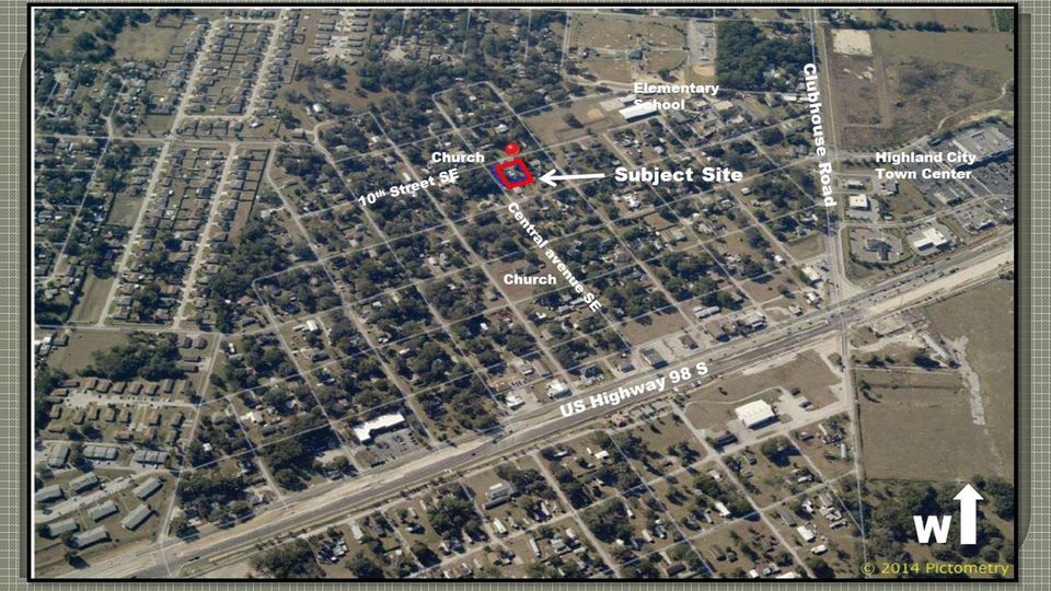
1 Highland City Refuge Church CPA /- acres Applicant Initiated Small Scale Residential Low (RLX) to Institutional (INSTX) in US Highway 98 SAP
 in US Highway")
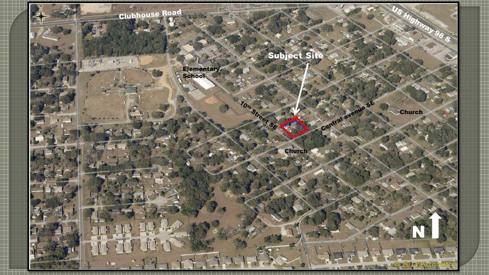
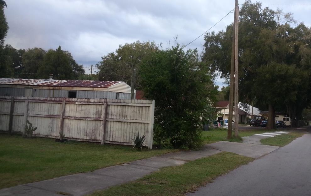
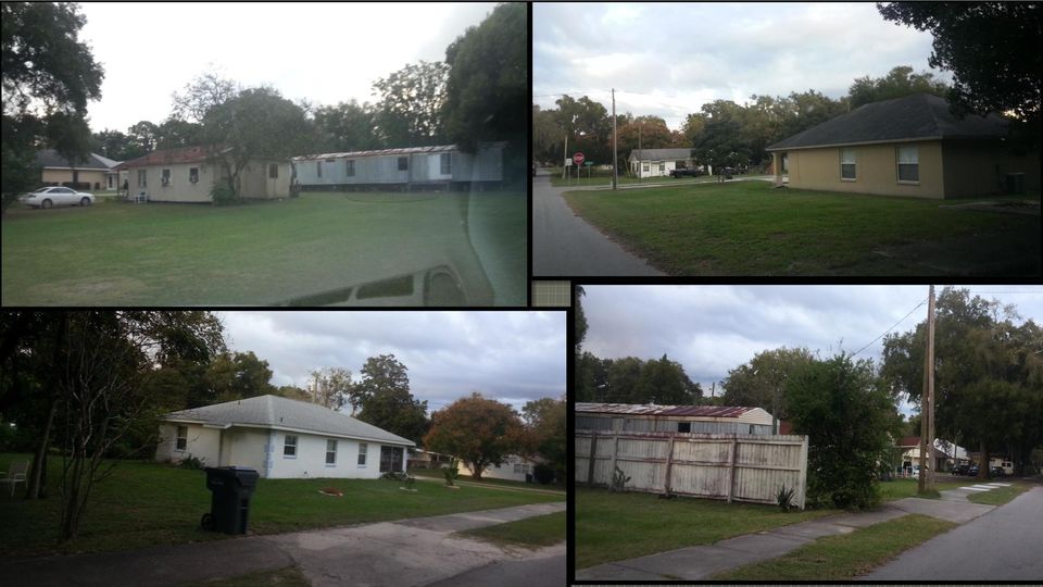
2 Location Map The subject property is located northeast corner of 10 th street SE and Central Avenue SE, approximately 1600 feet west of US Highway 98 South, in Highland City. in Section 14, Township 29 and Range 24.


3 Current Future Land Use: Residential Low (RLX) Proposed Future Land Use: Institutional (INSTX)

4

5
6

7


8 S S E S
9
10 FLU PERMITTED (BY RIGHT) CONDITIONAL USE LEVEL 1 OR 2 REVIEW (STAFF REVIEW ONLY) CONDITIONAL USE LEVEL 3 REVIEW (1 PUBLIC HEARING REQUIRED) CONDITIONAL USE LEVEL 4 REVIEW (2 PUBLIC HEARINGS REQUIRED) RLX Single Family Detached Home and Subdivision, Utilities I Family Farm, Family Homestead, Small Group Home (less than 6 residents), Large Group Home (7-14 residents), Mobile Homes (Individual), Residential Infill, Duplex (Two Family Attached), Small Bed and Breakfast, Emergency Shelter (6 or less residents), Medium Emergency Shelter (7-14 residents), Golf Course, Recreation Passive, Recreation Low- Intensity, Schools (Elementary/Middle) Utilities II Fly-in Communities, Group Living Facility (15 or more residents), Seasonal Farm Worker Housing, Mobile Home Parks and Subdivisions, Multifamily, Planned Development, Residentially Based Mixed Use Development, Adult Day Care (7 or more clients), Childcare Center, Community Center, Cultural Facility, Emergency Shelter (15 or more residents), Government Facility, Helistops, Mining Non-Phosphate, Recreation (High Intensity), Recreation Vehicle Oriented, Religious Institution, Schools (/High), School Leisure/Special, Transitional Area Development, Utilities III INSTX Childcare Center, Government Facilities, Institutional Campgrounds, Lodges and Retreats, Schools (Elementary/Middle), School, Leisure/ Special Interest, Utilities, Class I and Utilities, Class II Group Home Large (7 to 14 residents), Group Living Facility (15 or more residents), Adult Daycare, (7 or more Clients), Cemetery, Clinic & Medical Offices, Communication Towers, Community Center, Cultural Facility, Emergency Shelter (7-14 residents), Emergency Shelter (15 or more residents), Heliports, Helistops, Nursing Homes, Office,, Office Park, Recreation - Passive, Recreation High Intensity, Recreation Low intensity, Religious Institution, Research and Development, Solar Electric-Power Generating Facility Multifamily, Planned Development, Agricultural Support (On Site), Financial Institution - Drive thru, Hospitals, Lime Stabilization Facilities, Mining Non-Phosphate,, Residential treatment Facilities, Printing and Publishing, Schools (High), School, Technical/ Vocational/Trade, School, Training, School University/ College, Sea Plane Base, Transit Facility, Water Ski School.. Utilities, Class III Source: Polk County Land Development Code Chapter 4, Table 4.12
 Utilities II Fly-in Communities, Group Living Facility (15 or more residents), Seasonal Farm Worker Housing, Mobile Home Parks and Subdivisions,")
11 Schools Parks Sheriff Fire EMS Water Sewer Transportation Urban Sprawl Impact Assessment Development in the INST is not expected to increase the number of students Supported by a Regional Park 2.3 +/- miles from site 2,500 +/- feet from site 3.2 +/- miles from site Provided by City of Lakeland; Capacity is available Septic tank; Capacity is available Capacity is available This is not urban sprawl because surrounding area is already developed

 - Transit Supportive Development Area (TSDA) Appendix 2.131-R US Highway 98 SAP Section 2.")
12 Consistency to Comprehensive Plan Section (Policies A1 thru A15) - General Growth Management policies Section (Policies A1 thru A6) - Transit Supportive Development Area (TSDA) Appendix R US Highway 98 SAP Section Institutional Polk Vision Increase in intensity occurs where infrastructure is available Sense of Community and Social Service, Compatible with surrounding residential neighborhood The Development Review Committee, based on the information provided for this request, as well as, a recent site visit to the subject site, finds the proposed request IS COMPATIBLE with the surrounding land use designations and IS CONSISTENT with the Comprehensive Plan and recommends APPROVAL of CPA 16S-03.

R-40 Single-Family Residential
 October 7, 2013 R-40 Single-Family Residential Description: This low-density district allows single-family structures on lots of at least 40,000 square feet (0.92 acres). Properties zoned R-40 are typically
FUTURE LAND USE ELEMENT
 GOALS, OBJECTIVES AND POLICIES FUTURE LAND USE ELEMENT GOAL A THE CITY OF FORT WALTON BEACH WILL PLAN FOR AND PROVIDE A HIGH QUALITY OF LIFE TO MEET THE NEEDS OF THE CURRENT AND FUTURE POPULATION, PROVIDING
A. Permitted uses. The following uses are permitted by right in the C-2 zone, subject to the limitations specified:
 1 of 8 4/6/2015 1:11 PM Sacramento City Code Up Previous Next Main Collapse Search Print No Frames Title 17 PLANNING AND DEVELOPMENT CODE Division II ZONING DISTRICTS AND LAND USE REGULATIONS Chapter 17.216
NYE COUNTY, NV PAHRUMP REGIONAL PLANNING COMMISSION REGULAR MEETING JANUARY 15, 2014
 NYE COUNTY, NV PAHRUMP REGIONAL PLANNING COMMISSION REGULAR MEETING JANUARY 15, 2014 Staff Report Agenda Item No. 11 CASE DESCRIPTION(S): LOCATION: APPLICANT(S): For possible action - Bill No. 2014-01:
Attached (townhouses) SC P P 4.2.3(A)1 Duplex SE SE P Accessory Dwelling Unit (ADU) to a primary residence SC SC SC SC P 4.2.3(A)2
 SC P P 4.2.3(A)1 Duplex SE SE P Accessory Dwelling Unit (ADU) to a primary residence SC SC SC SC P 4.2.3(A)2") TABLE 1: ERMITTED USES BY ZONING DISTRICT Land Use : ermitted C: ermitted, subject to conditions SE: Special Exception SC: Special Exception, subject to conditions Zoning Districts NC 1,2,3,4 R I CMU GC
TABLE 1: ERMITTED USES BY ZONING DISTRICT Land Use : ermitted C: ermitted, subject to conditions SE: Special Exception SC: Special Exception, subject to conditions Zoning Districts NC 1,2,3,4 R I CMU GC
Class Rate Percentages of Real and Personal Property by Property Type Taxes Payable 2014 and 2015
 Class Rate Percentages of Real and Personal Property by Property Type Taxes Payable 2014 and 2015 Payable 2014 Payable 2015 1a Residential homestead Residential homestead 1b Blind/Disabled homestead Blind/Disabled
Zoning Districts, Gwinnett County, Georgia
 Zoning Districts, Gwinnett County, Georgia The zoning district descriptions in this section should be used as a guide only for the unincorporated areas of Gwinnett County. Before buying or selling property,
INTRODUCTION TO ZONING DISTRICT REGULATIONS
 INTRODUCTION TO ZONING DISTRICT REGULATIONS Classification of Zoning Districts Zoning districts in Dorchester County are categorized as Suburban Urban, Suburban Transition, or Rural. These districts are
APPENDIX 2.134 - ADOPTED NEIGHBORHOOD PLANS. Overview
 APPENDIX 2.134 - ADOPTED NEIGHBORHOOD PLANS Overview With the adoption of the Comprehensive Plan in 1991, the County recognized up to two dozen communities that were to be studied to encourage revitalization
HALFWAY HOUSES. Presented to the City Council. By the Planning and Development Department
 HALFWAY HOUSES Presented to the City Council By the Planning and Development Department June 4, 2013 1 Purpose Review State regulations for halfway houses. Review regulations and locations in Fort Worth
PLANNING COMMISSION REPORT Regular Agenda - Public Hearing Item
 Z-15-00063 Item No. 1-1 PLANNING COMMISSION REPORT Regular Agenda - Public Hearing Item PC Staff Report 04/20/2015 ITEM NO. 1 Z-15-00063 CS TO RS5; 832 Ohio Street (BJP) Z-15-00063: Consider a request
A PPENDICES C OLLIERVILLE 2040 LAND USE PLAN UPDATE
 A PPENDICES C OLLIERVILLE 2040 LAND USE PLAN UPDATE Traditional Neighborhood Character Study with a Neighborhood Center Commercial Node Aldi s is appropriate in a Neighborhood Center School Greenbelt Trail
(3) CATEGORY III means a permanent heliport facility. (4) COMMISSION means the City of Austin Airport Advisory Commission.
 CATEGORY III means a permanent heliport facility. (4) COMMISSION means the City of Austin Airport Advisory Commission.") 13-1-171 DEFINITIONS. (A) Terms not otherwise defined in this article have the meaning prescribed by applicable aviation law, including Federal Aviation Administration Advisory Circular 150/5390-2A (Heliport
13-1-171 DEFINITIONS. (A) Terms not otherwise defined in this article have the meaning prescribed by applicable aviation law, including Federal Aviation Administration Advisory Circular 150/5390-2A (Heliport
The intent of this chapter in establishing the R-G Residential General District is as follows:
 Atlanta, Georgia, Code of Ordinances >> PART III - CODE OF ORDINANCES LAND DEVELOPMENT CODE >> Part 16 - ZONING >> CHAPTER 8. - R-G RESIDENTIAL GENERAL DISTRICT REGULATIONS >> CHAPTER 8. - R-G RESIDENTIAL
COUNTY OF ELBERT. 18 September, 2014 For the Planning Commission meeting of 25 September, 2014 ELBERT COUNTY PLANNING COMMISSION
 COMMUNITY & DEVELOPMENT SERVICES OFFICE P.O. BOX 7 215 COMANCHE STREET KIOWA, COLORADO 80117 303-621-3136 FAX: 303-621-3165 COUNTY OF ELBERT 18 September, 2014 For the Planning Commission meeting of 25
Neighborhood Planning Guide To Zoning
 City of Austin Neighborhood Planning Guide To Zoning City of Austin Planning & Development Review Department 505 Barton Springs Road One Texas Center Austin, TX 78704 June 2014 DISCLAIMER: This Guide is
A-2, RURAL ESTATE-AGRICULTURE DISTRICT
 CHAPTER 52 A-2, RURAL ESTATE-AGRICULTURE DISTRICT SECTION: 10-52-1: Purpose 10-52-2: Permitted Uses 10-52-3: Accessory Uses 10-52-4: Conditional Uses 10-52-5: Interim Uses 10-52-6: Lot Area, Density, and
Chapter 7 ZONING PLAN
 Chapter 7 ZONING PLAN Introduction This Chapter opens with a general description of a zoning plan. It is followed by a brief explanation of the relationship between this Growth Management Plan and the
KEYPORT COMMUNITY PLAN
 PLANNING COMMISSION TASKS Collect Public Comments on Draft Plan. Provide Clear Direction for: Preferred LAMIRD Boundary Lot Clustering Provision View Protection Recommendation to Board of County Commissioners.
TOWN OF CARY CONDITIONAL USE ZONING PERMIT. 412 Rutherglen Cary, NC 27511-6437. 412 Rutherglen Cary, NC 27511-6437
 TOWN OF CARY CONDITIONAL USE ZONING PERMIT PETITION: PETITIONER(S): OWNER(S): LOCATION: 01-REZ-16 204 N. Dixon Avenue, Cary, NC PARCEL IDENTIFICATION: 076418218784 REALID: 0031004 AREA: APPROVED ZONING:
Appendix A: Affordable Housing Site Inventory
 Appendix A: Affordable Housing Site Inventory Following is a brief summary of the various sites considered for the Affordable Housing Project. Each site is provided with a photo when available and a concise
The Metropolitan Planning Commission. DATE: May 19, 2015
 TO: FROM: The Metropolitan Planning Commission MPC Staff DATE: May 19, 2015 SUBJECT: Petition of LLC, Owner Harold Yellin, Agent PIN: 2-0015-01-002 & 003 Lot Size:.85 Acres (approximately) Aldermanic District:
ALACHUA COUNTY COMPREHENSIVE PLAN 2011-2030
 ALACHUA COUNTY COMPREHENSIVE PLAN 2011-2030 Adopted April 5, 2011 (Ordinance 11-01, Effective July 22, 2011; Housing Element effective August 23, 2011) Updated through January 21, 2016 Alachua County Growth
LAND USE ELEMENT APPENDIX
 II LAND USE ELEMENT APPENDIX Arnold Community Plan CHART C CONSISTENT ZONES, POPULATION DENSITY, BUILDING INTENSITY Land use designation Consistent Dwellings Persons Zone per acre per acre Single family
SACRAMENTO COUNTY SUMMARY OF ZONING CLASSIFICATIONS
 SACRAMENTO COUNTY SUMMARY OF ZONING CLASSIFICATIONS This document provides a brief overview of zoning designations only. Inaccuracies may be present. Please consult the Sacramento County Zoning Code for
Bed & Breakfast Facilities Criteria. / Questionnaire. Definition (per Section 56.10): SECTION 56.20 - CONDITIONAL USE:
: SECTION 56.20 - CONDITIONAL USE:") Bed Bed & Breakfast Facilities Criteria / Questionnaire The intent of the Hood river County Zoning Ordinance Article 56 and Breakfast Facilities is to protect the character of single family residential
Bed Bed & Breakfast Facilities Criteria / Questionnaire The intent of the Hood river County Zoning Ordinance Article 56 and Breakfast Facilities is to protect the character of single family residential
October 2009. Water Demand Factor Update Report, October 2009 Page 1
 WATER DEMAND FACTOR UPDATE REPORT Prepared by Water Resources Division, City of Santa Barbara, in conjunction with the Planning Division, City of Santa Barbara October 2009 Background In 1989, the City
Senior Housing Plan Comprehensive Plan Update. Village of Lombard Department of Community Development. October 2011
 Senior Housing Plan Comprehensive Plan Update Village of Lombard Department of Community Development October 2011 This page intentionally left blank. Introduction The purpose of the Senior Housing Plan
28.0 Development Permit Area #2 (Neighbourhood District)
") 28.0 Development Permit Area #2 (Neighbourhood District) Goals and Objectives To provide a guide for infill and new development in the Neighbourhood District. To outline the nature, form and character
28.0 Development Permit Area #2 (Neighbourhood District) Goals and Objectives To provide a guide for infill and new development in the Neighbourhood District. To outline the nature, form and character
Sec. 26-88-120. - Vacation Rentals.
 Sec. 26-88-120. - Vacation Rentals. (a) Purpose. This section provides requirements and standards for the operation of vacation rentals. These standards are intended to ensure that vacation rentals are
SECTION ONE CHAPTER 2: A LAND USE PROFILE OF MANCHESTER
 SECTION ONE CHAPTER 2: A LAND USE PROFILE OF MANCHESTER Land use is the central element of a comprehensive plan because it establishes the overall physical configuration of the city, including the mix
SEC. 37-7.4. R-4 SINGLE FAMILY RESIDENCE DISTRICT
 SEC. 37-7.4. R-4 SINGLE FAMILY RESIDENCE DISTRICT The R-4 Single Family Residence District is established to preserve and maintain existing single family areas of the County and permit the continued development
d. Building permits may only be approved if consistent with the approved development plan and land division for all units with common walls.
 Section 20.920.060 Tier 2 Infill Standards. In addition to the Tier 1 standards and incentives, Tier 2 infill parcels and land divisions and the subsequent development on those Tier 2 infill parcels shall
7.0 INTRODUCTION 7.1 BACKGROUND
 Section 7: Economic Development 7.0 INTRODUCTION A community s character is a function of its residential neighborhoods, its open spaces, and its commercial districts. Commercial uses also play another
ARTICLE 323. PD 323. Urbandale Area Special Purpose District
 ARTICLE 323. PD 323. Urbandale Area Special Purpose District SEC. 51P-323.101. LEGISLATIVE HISTORY. PD 323 was established by Ordinance No. 20485, passed by the Dallas City Council on October 25, 1989.
TOWN BOARD OF THE TOWN OF NORTH SALEM WESTCHESTER COUNTY, NEW YORK LOCAL LAW # OF THE YEAR 2012
 TOWN BOARD OF THE TOWN OF NORTH SALEM WESTCHESTER COUNTY, NEW YORK LOCAL LAW # OF THE YEAR 2012 CHAPTER 250, ZONING ORDINANCE AMENDMENTS - PD-CCRC DISTRICT Section 1. Purpose: The purpose of this Local
Section 13 Urban Residential Zones
 Section 13 Urban Residential Zones 13.1 RU1 Large Lot Housing RU1c Large Lot Housing with Carriage House RU1h Large Lot Housing (Hillside Area) RU1hc Large Lot Housing (Hillside Area) with Carriage House
Schedule A. Residential and Seasonal Dwellings. for estimating value of construction in the Township of North Kawartha
 Schedule A Classification of buildings used for estimating value of construction in the Township of North Kawartha Estimated cost of Construction per square foot Residential and Seasonal Dwellings Single
Rezoning case no. RZ15-08: Adam Development Properties, LP
 PLANNING AND ZONING COMMISSION STAFF REPORT June 4, 2015 Rezoning case no. RZ15-08: Adam Development Properties, LP CASE DESCRIPTION: LOCATION: a request to amend the development plan of a previously-approved
Prepared by: Samuel Dennis Date prepared: December 21, 2011
 Hillsborough County City-County Planning Commission EXECUTIVE SUMMARY Meeting Date: Agenda Item: January 9, 2012 - Planning Commission Public Hearing Tampa: Text Amendment to Public/Semi-Public Land Use
Table of Uses Residential Development
 Table of Uses Residential Development This chart is intended as a reference guide. Refer to Land Development Code additional information. ZONING DISTRICT Residential Uses (primary) Agricultural- Residential
A REQUEST FOR A CONDITIONAL USE PERMIT BY:
 A REQUEST FOR A CONDITIONAL USE PERMIT BY: National Outdoor Leadership School (NOLS), FOR: The expansion of their existing education facility, WHERE: Darby Townsite (1830 S 1750 E) Prepared for the Public
Table 200.5.10.1 PARKING SPACE RATES AND PARKING SPACE OCCUPANCY
 Table 200.5.10.1 PARKING SPACE RATES AND PARKING SPACE OCCUPANCY. AM = 6 a.m. to Noon. Adult Education School Adult Entertainment (A) in Policy Area 1 (PA1), Policy Area 2 (PA2) Policy Area 3 (PA3) at
Multifamily Housing: Sustainable Development in Efficient, Walkable Communities
 Multifamily Housing: Sustainable Development in Efficient, Walkable Communities by the Greater Charlotte Apartment Association Multifamily rental housing is a critical piece of the housing market in the
Restoration. a brief look at
 Copyright 2009 Canin Associates, Inc. All rights reserved. No part of this publication may be reproduced or transmitted by any means without written permission from Canin Associates, Inc. a brief look
PA-14-04/ORDINANCE 14-34 (DTS# 20140263) 24/7 DEVELOPMENT HOLDINGS, LLC BAYSHORE BLACKROCK
 24/7 DEVELOPMENT HOLDINGS, LLC BAYSHORE BLACKROCK") PC: 9-11-2014 PA-14-04/ORDINANCE 14-34 (DTS# 20140263) 24/7 DEVELOPMENT HOLDINGS, LLC BAYSHORE BLACKROCK Adoption of a Plan Amendment of the Board of County Commissioners of Manatee County, Florida, regarding
PC: 9-11-2014 PA-14-04/ORDINANCE 14-34 (DTS# 20140263) 24/7 DEVELOPMENT HOLDINGS, LLC BAYSHORE BLACKROCK Adoption of a Plan Amendment of the Board of County Commissioners of Manatee County, Florida, regarding
ICMA Insights TM Key Performance Indicators
 ICMA Insights TM Key Performance Indicators While the ICMA Insights program as a whole enables the tracking of more than 900 performance measures, a subset of these are used in pre-formatted reports and
MOBILE HOME LAW. Revised November 2001
 MOBILE HOME LAW Revised November 2001 TABLE OF CONTENTS: SECTION 1: SECTION 2: SECTION 3: SECTION 4: SECTION 5: SECTION 6: SECTION 7: SECTION 8: SECTION 9: SECTION 10: SECTION 11: SECTION 12: INTENT DEFINITIONS
DOUGLAS COUNTY ZONING RESOLUTION Section 5 RR - Rural Residential District 3/10/99. -Section Contents-
 SECTION 5 RR - RURAL RESIDENTIAL DISTRICT -Section Contents- 501 Intent...5-2 502 Principal Uses...5-2 503 Accessory Uses...5-3 504 Uses Permitted by Special Review...5-4 505 Land Dedication...5-4 506
DRAFT POLICIES COUNTY OF HALIBURTON OFFICIAL PLAN UPDATE
 SETTLEMENT AREAS Introduction Urban Serviced DRAFT POLICIES These urban areas have either full or partial primary urban services, mainly water, sewage and roads. Functionally, they tend to service larger
AREA: 2.37 acres NUMBER OF LOTS: 1 FT. NEW STREET: 0 LF. Single-family, Non-conforming machine shop
 FILE NO.: Z-8958 NAME: Rock Structure Repair Short-form PID LOCATION: Located at 8024 Stanton Road DEVELOPER: Rock Structure Repair Attn. Rudy Gutierrez 3 Kipling Court Little Rock, AR 72209 ENGINEER:
BOROUGH COUNCIL BOROUGH OF SELLERSVILLE BUCKS COUNTY, PENNSYLVANIA ORDINANCE NO. 685
 BOROUGH COUNCIL BOROUGH OF SELLERSVILLE BUCKS COUNTY, ENNSYLVANIA ORDINANCE NO. 685 "MR-1 District Ordinance and Map Amendment" AN ORDINANCE AMENDING THE CODE OF THE BOROUGH OF SELLERSVILLE, CHATER 160
APPENDIX B. Farmville Airport Access and Land Use Study. Individual Land Use Policy Reviews August 2008
 Introduction APPENDIX B Individual Land Use Policy Reviews August 2008 A land use policy review was undertaken to understand the land use and other inter-related policy issues that may influence the Farmville
Warehouse & Parcel Adjoining Lumpkin County Airport
 SOLD!!! Warehouse & Parcel Adjoining Lumpkin County Airport $ 229,000 1730 Camp Wahsega Road, Dahlonega, GA 30533 WEB: LumpkinCountyAirportParcel.com» Commercial» 4.23 Acres Adjoining Lumpkin County Airport»
CITY OF SANTA ROSA DEPARTMENT OF COMMUNITY DEVELOPMENT STAFF REPORT FOR PLANNING COMMISSION SEPTEMBER 13, 2012 APPLICANT FILE NUMBER CUP12-042
 ITEM NO. 10 CITY OF SANTA ROSA DEPARTMENT OF COMMUNITY DEVELOPMENT STAFF REPORT FOR PLANNING COMMISSION SEPTEMBER 13, 2012 PROJECT TITLE Turning Point Residential Treatment Center ADDRESS/LOCATION 440
CITY OF KELOWNA BYLAW NO. 10515
 SUMMARY: The Development Cost Charge Bylaw sets out the charges imposed for roads, water, sanitary sewer, drainage and public park when subdividing or constructing, altering or extending a building, pursuant
FILING REQUIREMENTS EXCERPTS FROM THE ZONING ORDINANCE SOLAR ENERGY SYSTEMS
 County of San Diego, Planning & Development Services APPLICANT S GUIDE FOR A SOLAR ENERGY SYSTEM ZONING DIVISION These guidelines provide information on how to apply for a Solar Energy System. Review the
Note: The following are informal notes based on information received during this public meeting.
 Town of Colonie, New York Housing and Neighborhoods Focus Group Meeting Notes October 7, 2004 The Crossings at Colonie T H E S A R A T O G A A S S O C I A T E S LANDSCAPE ARCHITECTS, ARCHITECTS, ENGINEERS,
REZONING 16-000009 & PRELIMINARY PLAT 16-000005
 REZONING 16-000009 & PRELIMINARY PLAT 16-000005 REZONING REQUEST AND REVISED PRELIMINARY PLAT FOR THE BLUFFS AT WINDCASTLE - 4165 FAREDALE LANE Application: Engineer: Developer: Property Owner: Current
For Sale Apartment Site
 $2,995,000 LOCATION SUMMARY 1/4 mile from Huntersville Business Park 1 mile south of Exit 23 and close proximity to Presbyterian Hospital PROPERTY SUMMARY 18.48 Acres 1,800+ feet of frontage on I 77 and
Near West Side Comprehensive Plan Executive Summary (Revised) April 2004 City of Milwaukee DCD
 April 2004 City of Milwaukee DCD") Near West Side Comprehensive Plan Executive Summary (Revised) April 2004 City of Milwaukee DCD Boundaries The Near West Side Comprehensive Plan covers a broad area immediately west of Milwaukee s downtown.
Near West Side Comprehensive Plan Executive Summary (Revised) April 2004 City of Milwaukee DCD Boundaries The Near West Side Comprehensive Plan covers a broad area immediately west of Milwaukee s downtown.
Eureka Township Strategic Vision
 Working Draft Eureka Township Strategic Vision This is a working draft of a land use plan for Eureka Township. It is being presented to the public by the Citizens Advisory Committee to promote discussion
Baker County Comprehensive Plan. A Future Land Use Element Goals, Objectives, and Policies Appendices
 GOALS, OBJECTIVE, AND POLICIES Baker County A Future Land Use Element Goals, Objectives, and Policies Appendices Baker County 2020 Future Land Use Element A GOALS, OBJECTIVE, AND POLICIES This page intentionally
EAST MANCHESTER TOWNSHIP ZONING ORDINANCE
 EAST MANCHESTER TOWNSHIP ZONING ORDINANCE 2007 Comprehensive Update ORDINANCE NO. 2007-6 December 13, 2007 Includes Amendments Dated December 27, 2006 November 13, 2007 December 11, 2007 Prepared For East
Churches and Schools Development Standards
 Uses Code Provisions Site Development Standards RS-4 Sec.24-44 RD Sec. 24-45 RM-23 Sec. 24-48 Residential Single Family Residential Two- Family (Duplex) Residential Mid- Rise Multifamily (High Density)
REPORT OF THE PLANNING AND DEVELOPMENT DEPARTMENT FOR APPLICATION FOR REZONING ORDINANCE 2015-0183 TO PLANNED UNIT DEVELOPMENT APRIL 9, 2015
 AWH REPORT OF THE PLANNING AND DEVELOPMENT DEPARTMENT FOR APPLICATION FOR REZONING ORDINANCE 2015-0183 TO PLANNED UNIT DEVELOPMENT APRIL 9, 2015 The Planning and Development Department hereby forwards
INVENTORY OF CITY FACILITIES
 The City of Sachse operates and maintains its public buildings to serve the citizens of the community. Identification of the purpose, function and current use of each of these buildings is necessary to
VANDERBILT COMPARISON
 Village of Vanderbilt Comparison One County, One Vision Master Plan (2000) 1 15 Improve recreation in Otsego County by assessing the availability and need to improve bike paths, county recreation facilities,
ECONOMIC DEVELOPMENT, NEIGHBORHOODS, AND STRATEGIC PLANNING DEPARTMENT M E M O R A N D U M
 ECONOMIC DEVELOPMENT, NEIGHBORHOODS, AND STRATEGIC PLANNING DEPARTMENT M E M O R A N D U M DATE: February 27, 2008 TO: FROM: SUBJECT: Ray Giometti, Planning Commission Chair Members of the Planning Commission
How American Homes Vary By the Year They Were Built
 How American Homes Vary By the Year They Were Built By Mousumi Sarkar Demographic Directorate Housing and Household Economic Statistics Working Paper No. 2011-18 U.S. Census Bureau Washington, DC 20233
County of San Diego, Planning & Development Services SECOND DWELLING UNIT
 County of San Diego, Planning & Development Services ZONING DIVISION The Zoning Ordinance, Section 6156.x, allows the addition of a second dwelling unit to those properties zoned to allow the Family Residential
AGENDA LARIMER COUNTY PLANNING COMMISSION Wednesday, April 20, 2016/6:30 P.M./Commissioners' Hearing Room
 AGENDA LARIMER COUNTY PLANNING COMMISSION Wednesday, April 20, 2016/6:30 P.M./Commissioners' Hearing Room A. CALL TO ORDER B. PLEDGE OF ALLEGIANCE C. PUBLIC COMMENT ON THE COUNTY LAND USE CODE D. PUBLIC
Submit a copy of your license issued by the Department of Social and Health Services.
 Skamania County Community Development Department Building/Fire Marshal Environmental Health Planning Skamania County Courthouse Annex Post Office Box 1009 Stevenson, Washington 98648 Phone: 509-427-3900
CHAPTER SIXTEEN PLANNING STANDARDS AND RATIOS
 CHAPTER SIXTEEN PLANNING STANDARDS AND RATIOS INTRODUCTION To the maximum extent possible, the Update proposes to incorporate the planning standards and ratios used in the Nevada County General Plan. This
How To Improve Service In Arundel
 Draft of Economic Development Strategy - Town of Arundel Chapter 3.3 - Infrastructure, Transportation and Zoning 1. Infrastructure The lack of infrastructure in Arundel could present significant problems
ARTICLE II: LAND USE REGULATIONS
 Section 98-201 Purpose Section 98-203 Tables of Land Uses ARTICLE II: LAND USE REGULATIONS Section 98-201 Purpose The purpose of this Article is to indicate which land uses may locate in each zoning district
FIRE & LAW ENFORCEMENT IMPACT FEE UPDATE STUDY
 FIRE & LAW ENFORCEMENT IMPACT FEE UPDATE STUDY FINAL REPORT June 24, 2014 (with minor revisions in ) Prepared for: 228 S. Massachusetts Avenue Lakeland, FL 33801 (863) 834-6000 Prepared by: 1000 N. Ashley
Town of Mt. Crested Butte Five Year Financial/Business Plan
 Town of Mt. Crested Butte Five Year Financial/Business Plan 2014-2018 1 TABLE OF CONTENTS INTRODUCTION 3 CHAPTER 1: CURRENT FINANCIAL STATUS 5 CHAPTER 2: GOALS AND OBJECTIVES 8 CHAPTER 3: FINANCING THE
IF THEN SURVEY RESULTS
 IF THEN SURVEY RESULTS BUILDING TOWARDS A REGIONAL VISION Survey Summary April 2013 BACKGROUND In the spring of 2011, the Piedmont Triad undertook an ambitious, 3-year planning effort designed to strengthen
AREA: 0.16 acres NUMBER OF LOTS: 1 FT. NEW STREET: 0 LF
 FILE NO.: Z-9020 NAME: Hometown Tax Service Short-form PD-O LOCATION: Located at 3008 West 12 th Street DEVELOPER: Mark Green 65 Westfield Loop Little Rock, AR 72210 SURVEYOR: Kittler-Roberts Group, LLP
9.0 Alta Vista/Faircrest Heights/Riverview Park (Key Principles)
") 9.0 Alta Vista/Faircrest Heights/Riverview Park (Key Principles) Official Plan Consolidation for the City of Ottawa 1 9.1 Location This Chapter applies to Alta Vista/Faircrest/Riverview Park, which corresponds
9.0 Alta Vista/Faircrest Heights/Riverview Park (Key Principles) Official Plan Consolidation for the City of Ottawa 1 9.1 Location This Chapter applies to Alta Vista/Faircrest/Riverview Park, which corresponds
CITY OF GREEN COVE SPRINGS COMPREHENSIVE PLAN 2025
 CITY OF GREEN COVE SPRINGS COMPREHENSIVE PLAN 2025 Adopted August 2, 2011 CITY OF GREEN COVE SPRINGS COMPREHENSIVE PLAN 2025 ADOPTED 8/2/2011 TABLE OF CONTENTS Future Land Use Element... 1 Transportation
Town of Mt. Crested Butte Five Year Financial/Business Plan
 Town of Mt. Crested Butte Five Year Financial/Business Plan 2016-2020 TABLE OF CONTENTS INTRODUCTION 3 CHAPTER 1: CURRENT FINANCIAL STATUS 5 CHAPTER 2: GOALS AND OBJECTIVES 8 CHAPTER 3: FINANCING THE PLAN
City of Berkley, MI Historical Timeline
 City of Berkley, MI Historical Timeline 1815 Before 1815, the area along the Saginaw Trail, north of Twelve Mile Road (now Roseland Cemetery) was the site of Ottawa Indian Gardens. The Gardens included
City Code of ANN ARBOR, MICHIGAN Chapter 55 Zoning
 ARTICLE II. USE REGULATIONS 5:10.2. R1A, R1B, R1C, R1D single family dwelling district (1) Intent. (a) These single family residential districts are designed to provide an environment of predominantly
Information Packet SOLAR ENERGY SYSTEM (SES) WHEN IS A SOLAR ENERGY SYSTEM ZONEING PERMIT NECESSARY? Application for Solar Energy System
 WHEN IS A SOLAR ENERGY SYSTEM ZONEING PERMIT NECESSARY? Application for Solar Energy System") 1 Information Packet Land Use Management 509 W 5th Street Suite 103 Red Wing, MN 55066 s could require more than one application approval: Residential-Building Permit Commercial-SES Zoning Permit and Building
1 Information Packet Land Use Management 509 W 5th Street Suite 103 Red Wing, MN 55066 s could require more than one application approval: Residential-Building Permit Commercial-SES Zoning Permit and Building
Michigan State University Ingham County Health Department Tri- County Regional Planning Commission Land Use and Health Resource Team
 HEALTH IMPACT ASSESSMENT OF THE URBAN AND RURAL SERVICES MANAGEMENT POLICY Mid- Michigan Region Health In All Project Michigan State University Ingham County Health Department Tri- County Regional Planning
ARTICLE 619. PD 619. PD 619 was established by Ordinance No. 24960, passed by the Dallas City Council on June 12, 2002. (Ord.
 ARTICLE 619. PD 619. SEC. 51P-619.101. LEGISLATIVE HISTORY. PD 619 was established by Ordinance No. 24960, passed by the Dallas City Council on June 12, 2002. (Ord. 24960) SEC. 51P-619.102. PROPERTY LOCATION
ARTICLE 4 COMMERCIAL DISTRICT REGULATIONS TABLE OF CONTENTS
 ARTICLE 4 COMMERCIAL DISTRICT REGULATIONS TABLE OF CONTENTS PART 1 4-100 C-1 LOW-RISE OFFICE TRANSITIONAL DISTRICT SECTION 4-101 Purpose and Intent 4-102 Permitted Uses 4-103 Special Permit Uses 4-104
RM-1 Zoning Guide. The Anastasio Law Firm
 The Anastasio Law Firm THE 600 BLOCK OF PINE STREET RM-1 Zoning Guide The Anastasio Law Firm 1221 Locust Street, Suite 201 Philadelphia, Pa. 19107 (215) 609-4165 info@phillyzoning.com RM-1 RM-1 is a residential
ARTICLE 595. PD 595. SOUTH DALLAS/FAIR PARK SPECIAL PURPOSE DISTRICT
 ARTICLE 595. PD 595. SOUTH DALLAS/FAIR PARK SPECIAL PURPOSE DISTRICT SEC. 51P-595.101. LEGISLATIVE HISTORY. PD 595 was established by Ordinance No. 24726, passed by the Dallas City Council on September
Public Notice for Waiver of Aeronautical Land-Use Assurance. Indianapolis International Airport, Indianapolis, Indiana.
 This document is scheduled to be published in the Federal Register on 02/19/2015 and available online at http://federalregister.gov/a/2015-03485, and on FDsys.gov [4910-13] DEPARTMENT OF TRANSPORTATION
WESTFIELD-WASHINGTON ADVISORY PLAN COMMISSION December 7, 2015 1512-SPP-24 & 1512-ODP-24
 Petition Number: Subject Site Address: Petitioner: Request: East side of Oak Road, north of 151 st Street Langston Development Co. Primary Plat and Overall Development Plan amendment review for Mapleridge
Presentation of DISTRICT OF HOUSTON. 2010 TO 2014 Financial Plan
 Presentation of DISTRICT OF HOUSTON 2010 TO 2014 Financial Plan What is a Financial Plan? Why? 1) Prudent Planning! 2) Legal Requirement, Community Charter (s165 & s166) First year of the plan is the budget
Staff Report General Development Plan/Master Plan Aldermanic District: 1 County Commission District: 2 MPC File No. 16-000526-PLAN February 23, 2016
 Staff Report General Development Plan/Master Plan Aldermanic District: 1 County Commission District: 2 MPC File No. 16-000526-PLAN February 23, 2016 1101 Bull Street One West Park Avenue 1107 Bull Street
THREE MILE PLAN/URBAN GROWTH BOUNDARY INTERGOVERNMENTAL AGREEMENT
 THREE MILE PLAN/URBAN GROWTH BOUNDARY INTERGOVERNMENTAL AGREEMENT THIS INTERGOVERNMENTAL AGREEMENT, entered into by and between the BOARD OF COUNTY COMMISSIONERS OF THE COUNTY OF GUNNISON, COLORADO, a
Major General Plan Amendment. Project Narrative
 Major General Plan Amendment BARNEY FARMS Project Narrative NEC of Signal Butte and Queen Creek Roads Prepared: Submitted to: TOWN OF QUEEN CREEK PLANNING DEPARTMENT 22350 South Ellsworth Road Queen Creek,
STAFF REPORT SUBJECT:
 STAFF REPORT SUBJECT: PRS 12-0781 PLANNING AREA: Town & Country REQUEST: Minor Modification to an Approved PD SECTOR Northwest APPLICANT: Sunforest Holdings, LLC Existing Zoning & Density/Intensity : PD
City of El Paso City Plan Commission Staff Report
 City of El Paso City Plan Commission Staff Report Revised Case No: SUSU14-00124 Fresno Place Replat A Application Type: Resubdivision Combination CPC Hearing Date: February 12, 2015 Staff Planner: Joaquin
Community Planning Development Overview of Development and Entitlement Processes. April 20, 2015
 Community Planning Development Overview of Development and Entitlement Processes April 20, 2015 1 Overview 1. Introduction to Community Planning & Development 2. Citywide and Small Area Plans What they