Warren Geissler, CAD-1 Geospatial Technical Specialist Training Center Manager. Background:
|
|
|
- Cecily Morgan
- 7 years ago
- Views:
Transcription
1 Migrating CAD into GIS Best Practices Warren Geissler, ACI Training Center Manager Geospatial Technical Specialist

2 Warren Geissler, CAD-1 Geospatial Technical Specialist Training Center Manager Background: Civil Engineering & Surveying 10 Years U.S.A.F CADD Manager in Colorado 15+ Years Instructor and Support Tech in Autodesk Channel

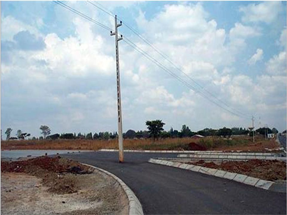
3 Why am I here? Engineers and Designers need more data earlier in the There is a huge disconnect between CAD and GIS. design process to make better decisions. More and more people are relying on data that is inaccurate, Developers needout more of complete date or incomplete. presentations and exhibits for plan review submittals. GIS needs This makes more BAD accurate THINGS and complete HAPPEN design as-built data for data stores.

4
5
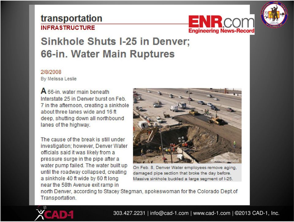
6 Bulldozer hits gas line; worker killed Joey Bunch and John Epperson The Denver Post November 12, 2006; Page C-01 Section: DENVER AND WEST Cheyenne - A jet-black, 300-acre burn site surrounded the skeletal hulk of a bulldozer that struck a natural-gas pipeline Saturday morning and produced a powerful explosion 2 miles north of the Wyoming-Colorado line. The bulldozer's operator, Bobby Ray Owens Jr., 52, of Louisiana was killed in the blast, but 13 pipeline workers escaped, authorities said

7 Why is this becoming an issue? Historically: ESRI (Environmental Systems Research Institute) has been the leading software development company for GIS desktop and enterprise level applications. Autodesk has been the leading software development company for Engineering, Design and Drafting (CAD) applications. Recently: Both industries (GIS and CAD) have become more integrated. Surveyors, Engineers and Designers are utilizing GIS data during planning stages and for bid preparation. GIS data is free (mostly) and readily accessible. GIS analysts are absorbing as-built CAD data for generating database layers. CAD data has survey-level spatial accuracy as well as important attribute information.
 have become more integrated. Surveyors, Engineers and Designers are utilizing GIS data during planning stages and for bid preparation.")
8 Some important notes about the tools The applications are not so dissimilar Both are used to compile maps of real-world conditions Both can input and create survey-level data Both are susceptible to GIGO Each tool has it s uses, strong and weak points CAD is used for DESIGN and DRAFTING Great for designing to survey level precision Useful for Construction Documentation Intelligent Design (BIM) tools GIS is used for DATA GATHERING, DISPLAY and ANALYSIS Adding attribution to features Display (Theme) mapping Data Analysis
 tools GIS is used for DATA GATHERING, DISPLAY and ANALYSIS Adding attribution to features Display (Theme) mapping")
9 On to the definitions In order to better integrate these two industries you need to learn how to speak both languages. Missteps could lead to wrong datasets, incorrectly geo-referenced files, bad decision making and wasted resources. BASIC TERMS: Data Store - A collection of feature data in a single storage location (a file or database such as Oracle). [AutoCAD=DRAWING] Feature Class - A category of features with rules that define the allowable data types, default values, and constraints for its member features. For example, you might have feature classes for a set of roads, utility poles, and so on. [AutoCAD=LAYER with no color or linetype] Schema A schema is the structure of the database that defines the objects in the database. [AutoCAD=Drawing Template with predefined layers, styles, etc.] Feature - The spatial representation of a real-world entity, such as a specific road or an individual utility pole, that specifies the geometry and other properties of the feature [AutoCAD=ENTITY] For example, you might use a data store such as Oracle, which can encompass multiple schemas. The database might define the utilities for a town, with schemas for different types of utilities, such as electrical and water. The electrical schema would include feature classes for utility poles and boxes, while the water schema would include feature classes for pipes and hydrants, each feature class would contain one or more features.

10 More definitions Feature Type GIS supports three distinct feature types Point (Node), Line (Curve) and Polygon (Surface). Points are any feature defined by one location (text, hatch, blocks). Polygons must be closed areas defined by one object. Only a few datastores will allow multiple feature types in one database. Spatial Database Any database type (Oracle, SQL, Access, etc) that can store spatial data (lines) Enterprise Database Large database type which allows for multiple-user access (via versioning) and management. (Oracle, SQL Server) Layer A Feature Class with stylization applied.[autocad=layer with color and linetype assigned] Attribute A property of a feature (manhole type, road width) [AutoCAD=ATTRIBUTE or TEXT LABEL] Metadata Information about a GIS database (coordinate system, attribute definitions, etc.) typically held in an HTML or XML document. Version A file which maintains a list of all of the edits made to a GIS datastore (by a particular person.) The datastore is not updated until all of the versions are checked in. Versions are incorporated into the datastore through rules. Constraints / Domains Drop-down lists for adding attributes. Transform The act of moving an existing map to a known coordinate system. Typically this involves moving, rotating, and sometimes scaling of the existing map. Two known coordinates (or locations) are required. (This term is often mixed up with Translate) Translate The act of moving data from a datastore from one coordinate system into another. Unlike transform (above) this requires a high level of math to shift each node of the data from one coordinate to another. (This term is often mixed up with Transform)
 Layer A Feature Class with stylization applied.")
11 Data Formats Data formats (How many?) GIS (ESRI) Shape file SHP DBF SHX PRJ DELETE.IDX FILES GDB (File Geodatabase) AutoCAD CANNOT use this without 3rd party software FME from SAFE Software AutoCAD DWG Can contain Point, Line and Polygon Can include attributes Can be exported to SHP Civil 3D Can export design data

12 GIS into CAD Workflow GIS into CAD Workflow Build list of required data. Start with one type of data and begin searching. Have a good idea where to look. Don t just look blindly. Understand that you may need multiple sources to combine into one datastore for all of the information you need. Check each type before moving on Import data and compile base map. Look at which data sets can be combined and/or migrated into a data store (Optional) Migrate into RDBMS AutoCAD Drawing Import and Evaluate GIS Data Compile Base Map (Optional) Extract AutoCAD Geometry

13 How to get GIS Data into CAD Enough with On to

14 GIS Needs Defined Data must be clean no drafting errors Data must be pertinent no extra layers Data must be transformed a real coordinate system Can be in ground units but needs the grid scaling factor supplied (also called a project scaling factor) Can be in grid units but this makes design and cost estimating in real-world units difficult Data must have metadata list of what is being supplied(layers, attributes, coordinate system, etc.) Data must have standards applied organization is the key. Data must have attributes Object Data, text labels, link templates. Layers and linetypes can be used but afford very limited attribution.
 Data must have standards applied organization is the key. Data must have attributes Object Data, text labels, link templates.")
15 Drawing Cleanup Clean Objects Layer Standards Coordinate Systems

16 CAD into GIS CAD into GIS Workflow Clean CAD data drafting errors Map Cleanup Purge Audit Remove attachments TRANSFORM data Change layers Layer Manager Remove unnecessary data Layer Delete MAPEXPORT to SDF file (Easier to attribute) Map any properties (Layer, Linetype, etc.) available Quickest method to move a large amount of data Add attribution as needed Export to SHP or use other tools for entry into GIS Mapexport Clean Drawing Organize data FDO Transfer
 available Quickest method to move a large amount of data Add attribution as needed Export to SHP or use other")
17 How to get GIS Data into CAD Enough with On to

18 Important notes on coordinate systems Coordinate systems are a mathematical means used to translate the somewhat round shape of the Earth to a flat medium (Paper maps). There are several coordinate systems in use. Coordinate systems can be (and have been) developed to account for GRID to GROUND translation. Both GIS and CAD have tools to translate data from one coordinate system to another The biggest hurdle in coordinate system management is getting the correct information from the source. A coordinate system designation has a minimum of TWO and up to FOUR distinct attributes. 1. DATUM: NAD 27, NAD 83, WGS 84, HARN/HPGN 2. PROJECTION: Lat/Long, UTM, State Plane 3. ZONE: UTM Zone 13, State Plane CENTRAL zone 4. LOCAL CONDITIONS: Units, Scaling Factor, Directions EXAMPLES: WGS 84.is NOT a coordinate system NAD 83 Colorado State Plane Central Zone US Foot IS a coordinate system Modified State Plane HOW IS IT MODIFIED?? HOW IS THE SCALE FACTOR APPLIED?? And Lastly.5000,5000,5000 IS NOT A PROPER COORDINATE SYSTEM!!!!

19 A quick check-up on Coordinate Systems What do they consist of? Datum (where am I measuring from?) Projection (How am I flattening the Earth?) Parameters (Where am I?) Grid vs. Ground? Survey Level Accuracy ~ 2cm /0.79 (ALTA 1999) Hand-Help GPS? ~ 3m Lat-Long DMS What is 1 second? Denver~ 90 AutoCAD supported precision? Floating Decimal (16 places) What do we design and as-built to? 0.01

20 Grid to Ground Issues Scale factors How are they acquired How are they applied Single point of reference Two Reference Points MAP 3D Coordinate systems New 2007 & 2011 adjustment system issues GIS Coordinate systems New 2007 & 2011 adjustment system issues

21 A word on Civil 3D and Proxy Graphics Much of what was shown today will NOT WORK ON CIVIL 3D OBJECTS!!! EXPORT: SDF Linear Data DEM Surface DWG Other EXPORT to AUTOCAD Note: The ESRI Data Interoperability Extension (FME) can absorb almost any data formats
22 Award Winning CAD-1 Services Classroom Training for upcoming schedule, visit Custom, In-Person, Mentoring Programs training programs tailored to your firm s specific needs. Implementation Assisting you in the addition of new software and workflows into your organization Online Mentoring Live mentoring and problem solving assistance delivered over the web. Online Training Live training delivered via web just like classroom training. All you need is an Internet connection. Support Excellent Telephone Support from CAD-1 Can Now be Combined with Web Based Tools for Fast Problem Resolution.. Call CAD-1 at for More Information on These Services info@cad-1.com
23 If you would like more information about the content provided here today, please contact us at: (Office)
Pennsylvania Geospatial Data Sharing Standards (PGDSS) V 2.5
 V 2.5") Submitted to: Pennsylvania Geospatial Data Sharing Standards (PGDSS) V 2.5 Spatial Data Migration Tools Report May 2, 2007 Table of Contents 1.0 Document Purpose...B-1 2.0 Overview of Spatial Data Migration
Submitted to: Pennsylvania Geospatial Data Sharing Standards (PGDSS) V 2.5 Spatial Data Migration Tools Report May 2, 2007 Table of Contents 1.0 Document Purpose...B-1 2.0 Overview of Spatial Data Migration
Questions and Answers for Citrix Ready Software
 AutoCAD Map 3D 2009 Questions and Answers for Citrix Ready Software AutoCAD Map 3D software is one of the leading engineering platforms for creating and managing spatial data. Bridging the gap between
GS 440 - It s Not Just a Smallworld Anymore
 GS 440 - It s Not Just a Smallworld Anymore Pat Reid Spatial Business Systems Autodesk Business Unit Director Dennis Beck Spatial Business System CEO Class Summary Overview of integration issue Solutions
Software: AutoCAD Civil 3D 2014, NRCS C3D 2014 template, ESRI ArcMap. Notation:Button to Press Displayed Text Icon Action {Text to Enter} Menu Item
 Overview: Use the following processes for exchanging georeferenced data between AutoCAD Civil 3D 2014 and ArcMap. The work must be based in any real world coordinate system. (This example uses NAD 83 UTM
Using CAD Data in ArcGIS
 Esri International User Conference San Diego, California Technical Workshops July 27, 2012 Using CAD Data in ArcGIS Jeff Reinhart & Phil Sanchez Agenda Overview of ArcGIS CAD Support Using CAD Datasets
Abstract. Introduction
 Data Replication and Data Sharing Integrating Heterogeneous Spatial Databases Mark Stoakes and Katherine Irwin Professional Services, Safe Software Inc. Abstract Spatial data warehouses are becoming more
Bentley ArcGIS. Connector
 Bentley ArcGIS Connector Introduction ESRI, as a GIS software products company, and Bentley Systems, Incorporated, as a developer of solutions for architecture/engineering/construction (AEC) professionals,
Data Integration for ArcGIS Users Data Interoperability. Charmel Menzel, ESRI Don Murray, Safe Software
 Data Integration for ArcGIS Users Data Interoperability Charmel Menzel, ESRI Don Murray, Safe Software Product overview Extension to ArcGIS (optional) Jointly developed with Safe Software Based on Feature
GEOGRAPHIC INFORMATION SYSTEMS
 GIS GEOGRAPHIC INFORMATION SYSTEMS FOR CADASTRAL MAPPING Chapter 6 2015 Cadastral Mapping Manual 6-0 GIS - GEOGRAPHIC INFORMATION SYSTEMS What is GIS For a long time people have sketched, drawn and studied
GIS Spatial Data Standards
 GIS Spatial Data Standards Manatee County, FL GIS Section, Information Services Department TABLE OF CONTENTS I. Introduction 2 A. Purpose 2 B. Reference 2 II. Spatial Reference Information 2 A. Projection:
GEOGRAPHIC INFORMATION SYSTEMS
 GIS GEOGRAPHIC INFORMATION SYSTEMS FOR CADASTRAL MAPPING Chapter 7 2015 Cadastral Mapping Manual 7-0 GIS - GEOGRAPHIC INFORMATION SYSTEMS What is GIS For a long time people have sketched, drawn and studied
From CAD to GIS: Editing and Distributing Geographic Information from CAD Software
 From CAD to GIS: Editing and Distributing Geographic Information from CAD Software Tzvika EL-AZ, Israel Key words: GIS, GeoERP, FELIS, GIS-ERP, Land and property system SUMMARY One of the challenges related
GIS Based Risk Analysis Simplifying the Risk Assessment Process
 GIS Based Risk Analysis Simplifying the Risk Assessment Process David Adler Principal Engineer System Integrity NiSource Gas Transmission and Storage John Beets Principal GIS Technologist Willbros Engineering
Data Interoperability Extension Tutorial
 Data Interoperability Extension Tutorial Copyright 1995-2010 Esri All rights reserved. Table of Contents About the Data Interoperability extension tutorial...................... 3 Exercise 1: Using direct-read
13/10/2011. Data Integration and Interoperability. Gordon Sumerling & Maree Wilson
 Data Integration and Interoperability Gordon Sumerling & Maree Wilson 1 Agenda Seamless integration between GIS and CAD CAD Support in ArcGIS Using GIS Data in CAD Editing GIS Data in CAD Introduction
Request for Proposal Autodesk CAD Support
 Request for Proposal Autodesk CAD Support Introduction Denver Water is inviting your firm to submit a proposal to provide Autodesk product-based services and support to meet the requirements of Denver
Certified Instructors & Curriculum
 Our Promise. TPM is dedicated to provide the most extensive and high-quality training programs to help you maximize your investment. Although the investment in time and money may seem substantial, it will
Autodesk Civil 3D Styles: A Guide to the Fundamentals
 AUTODESK CIVIL 3D WHITE PAPER Autodesk Civil 3D Styles: A Guide to the Fundamentals About the Author: Mark Scacco, PE, is the founder and president of Engineered Efficiency, Inc., a technology consulting
GEOGRAPHIC INFORMATION SYSTEMS CERTIFICATION
 GEOGRAPHIC INFORMATION SYSTEMS CERTIFICATION GIS Syllabus - Version 1.2 January 2007 Copyright AICA-CEPIS 2009 1 Version 1 January 2007 GIS Certification Programme 1. Target The GIS certification is aimed
CITY OF POWAY REQUEST FOR PROPOSALS (RFP) FOR GEOGRAPHIC INFORMATION SYSTEM (GIS) WATER / WASTEWATER SYSTEM DATA CONVERSION PROJECT ADDENDUM SIX
 FOR GEOGRAPHIC INFORMATION SYSTEM (GIS) WATER / WASTEWATER SYSTEM DATA CONVERSION PROJECT ADDENDUM SIX") CITY OF POWAY REQUEST FOR PROPOSALS (RFP) FOR GEOGRAPHIC INFORMATION SYSTEM (GIS) WATER / WASTEWATER SYSTEM DATA CONVERSION PROJECT ADDENDUM SIX In reference to the Request for Proposals for Geographic
CITY OF POWAY REQUEST FOR PROPOSALS (RFP) FOR GEOGRAPHIC INFORMATION SYSTEM (GIS) WATER / WASTEWATER SYSTEM DATA CONVERSION PROJECT ADDENDUM SIX In reference to the Request for Proposals for Geographic
ArcGIS Data Models Practical Templates for Implementing GIS Projects
 ArcGIS Data Models Practical Templates for Implementing GIS Projects GIS Database Design According to C.J. Date (1995), database design deals with the logical representation of data in a database. The
Coordinating and Sharing Information with Revit Architecture and Revit Structure Best Practices!
 Revit Architecture and Revit Structure Best Practices! Erleen Hatfield Thornton-Tomasetti Uk Jung SE304-1 This class identifies best practices using Revit Architecture and Revit Structure for sharing and
Guidelines to create Building Information Modelling (BIM) models for AAP, P1, SOM & SPC
 models for AAP, P1, SOM & SPC") Appendix 5 Guidelines to create Building Information Modelling (BIM) models for AAP, P1, SOM & SPC Preparation for Architectural Assessment Panel(AAP) Submission (Same details requirements on Revit models
Appendix 5 Guidelines to create Building Information Modelling (BIM) models for AAP, P1, SOM & SPC Preparation for Architectural Assessment Panel(AAP) Submission (Same details requirements on Revit models
Explore. Analyze. Optimize. AutoCAD. Civil 3d
 Explore. Analyze. Optimize. AutoCAD Civil 3d A Powerful Building Information Modeling Solution for Civil Engineering Use an integrated process built on a coordinated, consistent, digital model for design,
Explore. Analyze. Optimize. AutoCAD. Civil 3d
 Explore. Analyze. Optimize. AutoCAD Civil 3d A Powerful Building Information Modeling Solution for Civil Engineering Use an integrated process built on a coordinated, consistent, digital model for design,
Introduction to GIS. http://libguides.mit.edu/gis
 Introduction to GIS http://libguides.mit.edu/gis 1 Overview What is GIS? Types of Data and Projections What can I do with GIS? Data Sources and Formats Software Data Management Tips 2 What is GIS? 3 Characteristics
Geodatabase Programming with SQL
 DevSummit DC February 11, 2015 Washington, DC Geodatabase Programming with SQL Craig Gillgrass Assumptions Basic knowledge of SQL and relational databases Basic knowledge of the Geodatabase We ll hold
Lecture 2. Map Projections and GIS Coordinate Systems. Tomislav Sapic GIS Technologist Faculty of Natural Resources Management Lakehead University
 Lecture 2 Map Projections and GIS Coordinate Systems Tomislav Sapic GIS Technologist Faculty of Natural Resources Management Lakehead University Map Projections Map projections are mathematical formulas
SECTION 01 78 29 AS-BUILT DOCUMENTATION
 SECTION 01 78 29 AS-BUILT DOCUMENTATION PART 1: GENERAL 1.01 AS-BUILTS Where identified as a product of the Work, provide as-built drawings adhering to the criteria provided here and in the special conditions.
GIS Databases With focused on ArcSDE
 Linköpings universitet / IDA / Div. for human-centered systems GIS Databases With focused on ArcSDE Imad Abugessaisa g-imaab@ida.liu.se 20071004 1 GIS and SDBMS Geographical data is spatial data whose
Workflow improvement with FME in Skedsmo municipality
 Workflow improvement with FME in Skedsmo municipality Anders Hveem Malum (Geodata AS) and Turid Brox Nilsen (Skedsmo municipality) 16.05.2014 Skedsmo Kommune, Teknisk sektor 1 Skedsmo municipality Situated
Geospatially Enabling the World: The Convergence of Geospatial and Architectural and Engineering Design
 Geospatially Enabling the World: The Convergence of Geospatial and Architectural and Engineering Design Geoff Zeiss Director of Technology Autodesk Map Middle East Dubai 2007 1 Overview Geospatial inflection
INTRODUCTION TO ARCGIS SOFTWARE
 INTRODUCTION TO ARCGIS SOFTWARE I. History of Software Development a. Developer ESRI - Environmental Systems Research Institute, Inc., in 1969 as a privately held consulting firm that specialized in landuse
Guidelines on Information Deliverables for Research Projects in Grand Canyon National Park
 INTRODUCTION Science is playing an increasing role in guiding National Park Service (NPS) management activities. The NPS is charged with protecting and maintaining data and associated information that
GIS Architecture and Data Management Practices Boone County GIS Created and Maintained by the Boone County Planning Commission GIS Services Division
 GIS Architecture and Data Management Practices Boone County GIS Created and Maintained by the Boone County Planning Commission June 2008 Background Boone County s GIS program has been in existence for
Creating Figure Ground Maps in ArcMap 10.x: Basic procedures to download, open, manipulate and print spatial data
 Creating Figure Ground Maps in ArcMap 10.x: Basic procedures to download, open, manipulate and print spatial data These procedures outline: A. Retrieving Property Data B. Uncompressing the Downloaded Files
Subdivision Mapping: Making the Pieces Fit David P. Thaler, GIS Analyst A geographit White Paper, June 2009
 Subdivision Mapping: Making the Pieces Fit P David P. Thaler, GIS Analyst A geographit White Paper, June 2009 1525 Oregon Pike, Suite 202 Lancaster, PA USA 17601-7300 Phone: 717-399-7007 Fax: 717-399-7015
{ { { Meeting Date 08/03/10. City of Largo Agenda Item 24. Leland Dicus, P.E., City Engineer
 City of Largo Agenda Item 24 Form Revision Date: 10/19/09: Meeting Date 08/03/10 Presenter: Leland Dicus, P.E., City Engineer Department: CD Community Development TITLE: GIS PROGRAM UPDATE The implementation
BIM Department. BIM Modeling Using Faro Focus3D Laser Scanner
 BIM Modeling Using Faro Focus3D Laser Scanner Contents What is Laser Scanning? Advantages of Laser Scanning BIM Workflow Process Scanner Unit Set-up and Scanning Processing Scan Files BIM Software Creating
City of Grand Junction and inframap Software Mobile Field Application
 1 City of Grand Junction and inframap Software Mobile Field Application City Of Grand Junction Grand Junction Colorado Scott List inframap Software Adam Hagee Colin Kennedy Grand Junction Background 2
http://www.esri.com/bia
 ArcGIS for Tribal Transportation Management David Gadsden Federal Account Manager dgadsden@esri.com d d 1 David Gadsden GIS Background UW Geography (1995) Peace Corps Tanzania Environmental Social Science
A GIS helps you answer questions and solve problems by looking at your data in a way that is quickly understood and easily shared.
 A Geographic Information System (GIS) integrates hardware, software, and data for capturing, managing, analyzing, and displaying all forms of geographically referenced information. GIS allows us to view,
INTEGRATING BIM AND GIS FOR ASSET MANAGEMENT
 INTEGRATING BIM AND GIS FOR ASSET MANAGEMENT Andy Chan MHKIBIM Project Manager Spatial Technology Limited Agenda Introduction of Asset Management Why GIS is not sufficient for Asset Management Data model
LACKLAND AFB INVENTORY & CONDITION ASSESSMENT BASE SEWER COLLECTION &WATER DISTRIBUTION SYSTEMS
 LACKLAND AFB INVENTORY & CONDITION ASSESSMENT BASE SEWER COLLECTION &WATER DISTRIBUTION SYSTEMS Presenter: Ann Quinn ARCADIS / Malcolm Pirnie Date: May 12, 2011 Background Key Drivers AF implementation
GIS Data Models for INSPIRE and ELF
 GIS Data Models for INSPIRE and ELF Paul Hardy Roberto Lucchi EuroSDR/ELF Copenhagen Data Modelling and Model Driven Implementation of Data Distribution 28 Jan 2015 ArcGIS for INSPIRE Extends ArcGIS for
REQUEST FOR PROPOSALS
 REQUEST FOR PROPOSALS Solicitation Number: R-14-007-MR Transfer and Implementation of Data Records to GIS Ready Files ADDENDUM #2 05:00 PM Central June 5, 2014 This addendum answers questions submitted
Using GIS to Develop a Control Map and Database
 PENN STATE UNIVERSITY Using GIS to Develop a Control Map and Database SUR-351 Geodetic Models Brian E. Halchak & Rich Cebrick 12/2/2013 Table of Contents Abstract... 2 What is a GIS?... 2 Development of
ESRI Technical Certification Overview. Amy Daniels Instructor, Greenville Tech
 ESRI Technical Certification Overview Amy Daniels Instructor, Greenville Tech Why have certification by ESRI? It communicates your proficiency in ESRI software Similar to Microsoft Certification, it can
Getting Started with BIM (Building Information Modeling)
") Getting Started with BIM (Building Information Modeling) Curt Egli Synergis Building Solutions Engineer Session Summary This session will walk you through issues you should consider when strategizing,
Getting Started with BIM (Building Information Modeling) Curt Egli Synergis Building Solutions Engineer Session Summary This session will walk you through issues you should consider when strategizing,
Converting GIS Datasets into CAD Format
 Ball State University Libraries GIS Research and Map Collection Converting GIS Datasets into CAD Format Author: Angela Gibson, 6/13/2014 Overview: One of the most common requests from students is for GIS
Transition to 3D Fabrication Workflows
 Autodesk Autodesk Fabrication Solutions Transition to 3D Fabrication Workflows Autodesk is committed to the use of Building Information Modeling (BIM) to drive integrated and connected data across the
Applications & Operations - Resource Stewardship & Major Projects
 Temporary GIS Technician (12 Months) BC Oil & Gas Commission, Fort St John Grid 18 - $55,294.14 - $62,886.67* * Posted salary includes a JFMM Allowance of 10% & a Location Allowance of 3% Applications
Autodesk Solutions for Environmental Engineering. Engineering a better environment
 Autodesk Solutions for Environmental Engineering Engineering a better environment Better Engineering, Faster Design and deliver environmental engineering projects better, faster, and more economically.
GEOGRAPHIC INFORMATION SYSTEMS Lecture 20: Adding and Creating Data
 Adding Existing Data Into ArcGIS - there are many different ways to get data into ArcGIS GEOGRAPHIC INFORMATION SYSTEMS Lecture 20: Adding and Creating Data Add Data - normally we use the Add Data button
THURSTON COUNTY PUBLIC WORKS DEPARTMENT Design and Construction Division. CADD & Civil 3D User Guidelines. v2.0_12_12_09
 THURSTON COUNTY PUBLIC WORKS DEPARTMENT Design and Construction Division CADD & Civil 3D User Guidelines v2.0_12_12_09 THURSTON COUNTY PUBLIC WORKS DEPARTMENT DESIGN AND CONSTRUCTION DIVISION CADD & Civil
Database Production and Map Series Management. Using. The Production Line Tool Set
 Database Production and Map Series Management Using The Production Line Tool Set Dewey Marino - ESRI Redlands Production Line Tool Set ArcGIS Solution for high volume database and map creation Creates
NatureServe s Environmental Review Tool
 NatureServe s Environmental Review Tool A Repeatable Online Software Solution for Agencies For More Information, Contact: Lori Scott Rob Solomon lori_scott@natureserve.org rob_solomon@natureserve.org 703-908-1877
The user forum is an excellent community in which to bounce questions off other professional users, like you.
 INTRODUCTION Thank you for your interest in MicroSurvey Point Prep Point Prep is a simple to use desktop based product designed specifically for the construction layout professional. Point Prep is used
BIM Test At ASHRAE HQ
 This article was published in ASHRAE Journal, April 2011. Copyright 2011 American Society of Heating, Refrigerating and Air-Conditioning Engineers, Inc. Posted at www.ashrae.org. This article may not be
National Register of Historic Places: GIS Webinar Cultural Resource GIS Facility National Park Service June 2012
 National Register of Historic Places: GIS Webinar Cultural Resource GIS Facility National Park Service June 2012 In February and March 2012 the National Register of Historic Places held webinars in conjunction
City of Tigard. GIS Data Standards
 City of Tigard GIS Data Standards City of Tigard 13125 SW Hall Blvd Tigard, Oregon 97223 503 639-4171 Page 1 of 5 1.0 Purpose The purpose of these standards is to provide guidance for geospatial data development
A WORKFLOW ANALYSIS FOR BIM SOFTWARE: ARCHITECTURAL AND MECHANICAL ENGINEERING DEPARTMENT OF ARUP TURKEY
 ISTANBUL TECHNICAL UNIVERSITY FACULTY OF ARCHITECTURE DEPARTMENT OF DESIGN COMPUTING BIM 2037 / BUILDING INFORMATION MODELS INSTRUCTOR: Salih OFLUOĞLU A WORKFLOW ANALYSIS FOR BIM SOFTWARE: ARCHITECTURAL
Use this translator to save ArchiCAD layouts/views in DXF/DWG format if you plan to continue
 Tip Sheet ArchiCAD 11 Mark Horrocks Graphisoft New Zealand May 2007 DWG Translator In Architectural practice you often send and receive content from co-working Structural, Mechanical or Electrical Engineers.
1. We assume the mentioned inaccuracies refer to the at least one foot in ten thousand standard described in point three.
 RFQ GIS Parcel Boundary Correction Services BD 2015-035 Questions and Answers December 31st December 10 th 1. We assume the mentioned inaccuracies refer to the at least one foot in ten thousand standard
ADWR GIS Metadata Policy
 ADWR GIS Metadata Policy 1 PURPOSE OF POLICY.. 3 INTRODUCTION.... 4 What is metadata?... 4 Why is it important? 4 When to fill metadata...4 STANDARDS. 5 FGDC content standards for geospatial metadata...5
What s New in Autodesk Revit 2014
 Building Design Suite 2014 What s New in Revit 2014 * Revit 2014 software is only available as part of the Building Design Suite 2014 Premium and Ultimate Editions. New & Enhanced Features Platform & For
Civil Engineering Informatics Specialist
 Ministry of Communications and Information Technology Information Technology Institute Civil Engineering Informatics Specialist Engineering Informatics Intake 35 Historical Background! The Engineering
The Spatial Data Standards for Facilities, Infrastructure, and Environment Online (SDSFIE Online) Web Site. http://www.sdsfieonline.
 Web Site. http://www.sdsfieonline.") The Spatial Data Standards for Facilities, Infrastructure, and Environment Online (SDSFIE Online) Web Site http://www.sdsfieonline.org Mr. Kurt Buehler DISDI Program Support Image Matters LLC July 22,
The Spatial Data Standards for Facilities, Infrastructure, and Environment Online (SDSFIE Online) Web Site http://www.sdsfieonline.org Mr. Kurt Buehler DISDI Program Support Image Matters LLC July 22,
Best practice use of GI within utility companies From Desktop to the Field
 Best practice use of GI within utility companies From Desktop to the Field Agenda IMGS Introduction Historical Use of GI in utilities New Utility Trends GI - Moving off the island into the enterprise Integrated
TABLE OF CONTENTS. INTRODUCTION... 5 Advance Concrete... 5 Where to find information?... 6 INSTALLATION... 7 STARTING ADVANCE CONCRETE...
 Starting Guide TABLE OF CONTENTS INTRODUCTION... 5 Advance Concrete... 5 Where to find information?... 6 INSTALLATION... 7 STARTING ADVANCE CONCRETE... 7 ADVANCE CONCRETE USER INTERFACE... 7 Other important
Using Geocoded TIFF & JPEG Files in ER Mapper 6.3 with SP1. Eric Augenstein Earthstar Geographics Web: www.es-geo.com
 Using Geocoded TIFF & JPEG Files in ER Mapper 6.3 with SP1 Eric Augenstein Earthstar Geographics Web: www.es-geo.com 1 Table of Contents WHAT IS NEW IN 6.3 SP1 REGARDING WORLD FILES?...3 WHAT IS GEOTIFF
Managing Imagery and Raster Data in ArcGIS
 Technical Workshops Managing Imagery and Raster Data in ArcGIS Hong Xu, Sangeet Mathew, Mark Harris Presentation Overview ArcGIS raster data models Which model to use Mosaic dataset storage and properties
Creating 2D Drawings from 3D AutoCAD Models
 Creating 2D Drawings from 3D AutoCAD Models David Piggott CrWare, LP GD205-2P This class explores the various techniques in creating 2D part and assembly drawings from 3D AutoCAD models. As part of the
Suggested Application Options Settings for Autodesk Inventor
 Suggested Application Options Settings for Autodesk Inventor TEL: 0165 666 24 14 support@envisageuk.com PLEASE NOTE, THIS IS ONLY A GUIDE ANY QUESTIONS AT ALL PLEASE RING The following are suggested application
Quality Assessment in the framework of Map Generalization
 1/22/2015 1 Quality Assessment in the framework of Map Generalization Lysandros Tsoulos - Natalia Blana NATIONAL TECHNICAL UNIVERSITY OF ATHENS 1/22/2015 2 Contents Introduction Components of Map/Chart
<Insert Picture Here> Oracle BI Standard Edition One The Right BI Foundation for the Emerging Enterprise
 Oracle BI Standard Edition One The Right BI Foundation for the Emerging Enterprise Business Intelligence is the #1 Priority the most important technology in 2007 is business intelligence
5.2 Drawing Information. 0400 Consultants Procedure Manual. 5.2 Drawing Information: 5.2.2 Large Format Document Standards: Page 1 of 5
 Page 1 of 5 5.2 : 5.2.1 General Information:.1 Final drawings for all projects shall be one of the following sizes: 11" x 17", 24" x 36" or 30" x 42". The dimensions refer to the outside edge or cut line.
CAD Standards Guideline For Facility Documentation and Construction Projects
 CAD Standards Guideline For Facility Documentation and Construction Projects Implemented March 2010 Page 1 of 9 Table of Contents A. Software B. CAD Methods 1. Layer Standards 2. Font 3. Lineweights 4.
Gunnison County Web Map
 Gunnison County Web Map Find Data - Find data - Navigate tools - Mouse over tooltip Make Maps - Layers - Legend - Drawing tools - Printing Analysis - Measurement - Selecting - Queries Spatial SQL - Basic
CAD Standards Guideline For Facility Documentation and Construction Projects
 CAD Standards Guideline For Facility Documentation and Construction Projects Page 1 of 12 Table of Contents A. Software B. CAD Methods 1. Layer Standards 2. Font 3. Lineweights 4. External References 5.
Basic Understandings
 Activity: TEKS: Exploring Transformations Basic understandings. (5) Tools for geometric thinking. Techniques for working with spatial figures and their properties are essential to understanding underlying
Earth Coordinates & Grid Coordinate Systems
 Earth Coordinates & Grid Coordinate Systems How do we model the earth? Datums Datums mathematically describe the surface of the Earth. Accounts for mean sea level, topography, and gravity models. Projections
An Esri White Paper October 2010 Esri Production Mapping Product Library: Spatially Enabled Document Management System
 An Esri White Paper October 2010 Esri Production Mapping Product Library: Spatially Enabled Document Management System Esri, 380 New York St., Redlands, CA 92373-8100 USA TEL 909-793-2853 FAX 909-793-5953
TELECOM FIBER EDITING TOOLS REFERENCE GUIDE Version 1.2
 TELECOM FIBER EDITING TOOLS REFERENCE GUIDE Version 1.2 Prepared by: Esri 380 New York Street Redlands, California 92373-8100 Phone: (909) 793-2853 Table of Contents 1. Overview and Getting Started...
LNG Terminals. File Geodatabase Feature Class. Tags natural gas, lng, liquid natural gas, terminals
 LNG Terminals File Geodatabase Feature Class Tags natural gas, lng, liquid natural gas, terminals Summary This layer can be used to identify the location of existing and proposed LNG Terminals. Description
Kingdom Of Bahrain Ministry of Works. Enterprise Asset Management System A Geocentric Approach. Presented By Hisham Y.
 Kingdom Of Bahrain Ministry of Works Enterprise Asset Management System A Geocentric Approach Presented By Hisham Y. Sater April 2012 Ministry Of Works Bahrain MOW The construction arm of the Kingdom of
How To Improve Gis Data Quality
 An Esri White Paper July 2011 GIS Data Quality Best Practices for Water, Wastewater, and Stormwater Utilities Esri, 380 New York St., Redlands, CA 92373-8100 USA TEL 909-793-2853 FAX 909-793-5953 E-MAIL
Subject: Using Google Earth, Google Earth Pro, and Google Maps for FWS activities
 Subject: Using Google Earth, Google Earth Pro, and Google Maps for FWS activities Page 1 of 5 As an FWS employee, can I use Google mapping software or applications to help me with my job? The short answer
Tutorial 8 Raster Data Analysis
 Objectives Tutorial 8 Raster Data Analysis This tutorial is designed to introduce you to a basic set of raster-based analyses including: 1. Displaying Digital Elevation Model (DEM) 2. Slope calculations
An Introduction to Coordinate Systems in South Africa
 An Introduction to Coordinate Systems in South Africa Centuries ago people believed that the earth was flat and notwithstanding that if this had been true it would have produced serious problems for mariners
Introduction to GIS (Basics, Data, Analysis) & Case Studies. 13 th May 2004. Content. What is GIS?
 & Case Studies. 13 th May 2004. Content. What is GIS?") Introduction to GIS (Basics, Data, Analysis) & Case Studies 13 th May 2004 Content Introduction to GIS Data concepts Data input Analysis Applications selected examples What is GIS? Geographic Information
Introduction to GIS (Basics, Data, Analysis) & Case Studies 13 th May 2004 Content Introduction to GIS Data concepts Data input Analysis Applications selected examples What is GIS? Geographic Information
SECTION 5 DRAFTING STANDARDS
 SECTION 5 DRAFTING STANDARDS 1 SECTION FIVE TABLE OF CONTENTS Description Page TABLE OF CONTENTS... 5-2 GENERAL... 5-3 DRAFTING STANDARDS... 5-5 DRAFTING MINIMUM REQUIREMENTS HANDOUT... 5-8 2 GENERAL 1.
Request for Proposals for Topographic Mapping. Issued by: Teton County GIS and Teton County Engineering Teton County, Wyoming
 Request for Proposals for Topographic Mapping Issued by: Teton County GIS and Teton County Engineering Teton County, Wyoming Proposals due: 2:00PM MDT July 1, 2015 Proposals may be delivered to: Teton
A Comparison of ArcIMS to MapServer
 A Comparison of ArcIMS to MapServer Brock Anderson Refractions Research www.refractions.net 1 Refractions Research Victoria, BC, Canada Spatial Systems Consulting Open Source Software PostGIS udig / GeoTools
City of West Sacramento
 City of West Sacramento Request for Proposals Professional Consulting Services for a Geographical Information System (GIS) Strategic Plan Table of Contents RFP Section Background and Project Information
 Advanced ArcSDE Administration for SQL Server Shannon Shields Tony Wakim Workshop Format Three topics What's New In-depth Database Administration Trouble-shooting / Performance Selection varies year to
ArcGIS 10.1 Geodatabase Administration. Gordon Sumerling & Christopher Brown
 ArcGIS 10.1 Geodatabase Administration Gordon Sumerling & Christopher Brown Key Improvements at ArcGIS 10.1 1. Easier Administration through Graphic Interfaces 2. Greater Seamless integration with Open
Spanish examples IPR: Up to Date & Zones
 Spanish examples IPR: Up to Date & Zones 1 Spanish IPR examples We have chosen the open source option: Python Why Python? Easy to learn and understand for not it people and code can be freely used and
Is Your GIS Smart Grid Ready?
 Is Your GIS Smart Grid Ready? A State-of-the-Industry Report 2010 Prepared by ESRI Is Your GIS Smart Grid Ready? Survey Overview In the fourth quarter of 2009, ESRI conducted a smart-grid-readiness survey
Spatial Database Support
 Page 1 of 11 Spatial Database Support Global Mapper can import vector data from and export vector data to the following spatial databases: Esri ArcSDE Geodatabase Esri File Geodatabase Esri Personal Geodatabases