Ufs. No Notices to Mariners, SWEDEN Swedish Maritime Administration.
|
|
|
- Gwendolyn Simmons
- 7 years ago
- Views:
Transcription


1 Ufs No Notices to Mariners, SWEDEN Swedish Maritime Administration Editorial office Swedish Maritime Administration Ufs NORRKÖPING Sweden tel: Publisher: Hydrographer Patrik Wiberg

2 No 559 Affected charts and Notices Underrättelser för sjöfarande (Ufs) is an official Swedish publication which provides information pertaining to shipping in the Baltic Sea Area and Kattegat, as well as Skagerrak east of a line drawn between Hanstholm and Lindesnes. The information on foreign waters is largely confined to significant occurrences which may affect Swedish charts. Ufs is thus wholly unsuited for the purpose of keeping BAcharts and/or other national charts updated. An asterisk (*) in front of the number denotes that the notice is based on information obtained from Swedish source material and that the details contained therein affect Swedish waters. When the letter (P) is adjacent to the notice number it serves as an indication that the notice is of a preliminary nature. Such notices will later be replaced by corresponding ones containing definitive information. Similarly, when the letter (T) is placed adjacent to the notice number it denotes that the notice is of a temporary nature. In case no period of validity is given, this type of notice will be rendered invalid either when a new Temporary Notice is promulgated or if pertaining conditions cease to exist. Bearings are true and given clockwise from 000 to 360 and, when given in conjunction with lights, indicate a direction from seaward. Featured chartlets are primarily intended to simplify chart correction work and are not always true to scale. In general, they show the largest charted scale available for respective area. Responsibility for the factual content published in Ufs rests with the informant. Affected charts Notice no Sign (T) (T) (T) (T) (T) (T) (T) Chart corrections and other information attributed to a specific geographical area can be found under NOTICES. Other information is found under ANNOUNCEMENTS, starting on pg. 3. The periodical Ufs is normally published every Thursday and can be downloaded as a PDF-file from the homepage of the Swedish Maritime Administration. Note that as the file is automatically generated from a database unintentional page breaks may occur at random. Further information on the use of Ufs can be found in the annual publication Ufs A. Reporting dangers and errors All observations concerning floating aids to navigation, unlit beacons and lights, objects adrift or any other occurrence which may have a detrimental impact on safety at sea are to be forwarded to MSI Sweden at the earliest possible opportunity. Call: MSI Sweden VHF Channel: Appropriate working channel Phone: (24/7) msi@sjofartsverket.se
 in front of the number denotes that the notice is based on information obtained from Swedish source material and that the details contained therein affect Swedish waters.")
3 No 559 ANNOUNCEMENTS No Announcements in this booklet. NOTICES Bay of Bothnia * (T) Chart: 41, 421 Sweden. Bay of Bothnia. E of Byske. Tåme. Gunnery exercises August 18-30, Position: Approx N E Tåme Firing Restriction Area Gunnery exercises will be carried out from Tåme Firing range. The current extension of the closed area is given in the table. During firing a red balloon is shown from the observation towers. Further information on VHF channel 16, call Tåme skjutfält, or phone +46 (0) August Time Range from shore ,6 M ,5 M ,5 M ,5 M ,6 M Not shown in ENC. Bsp Bottenviken 2014/s06, s37 Försvarsmakten, Tåme skjutfält. Publ. 13 augusti 2015 Sea of Bothnia * Chart: 514 Sweden. Sea of Bothnia. Nordmaling. Port of Rundvik. Buoy marker. See: 2013:475/9183, 2014:476/9203 An orange-coloured buoy marker, indicated in which direction the anchor chain lies, has been deployed some 150 metres in NW-ly direction from the bow of the permanently moored barge. Insert buoy marker as shown 63-32,2N ,5E Bsp Bottenhavet N 2013/s25 Rundvik - Nordmaling Marinegroup AB. Publ. 13 augusti 2015 Northern Baltic * Chart: 6142 Sweden. Northern Baltic. Stockholm. Lidingö. Käppala. Sewage pipe.

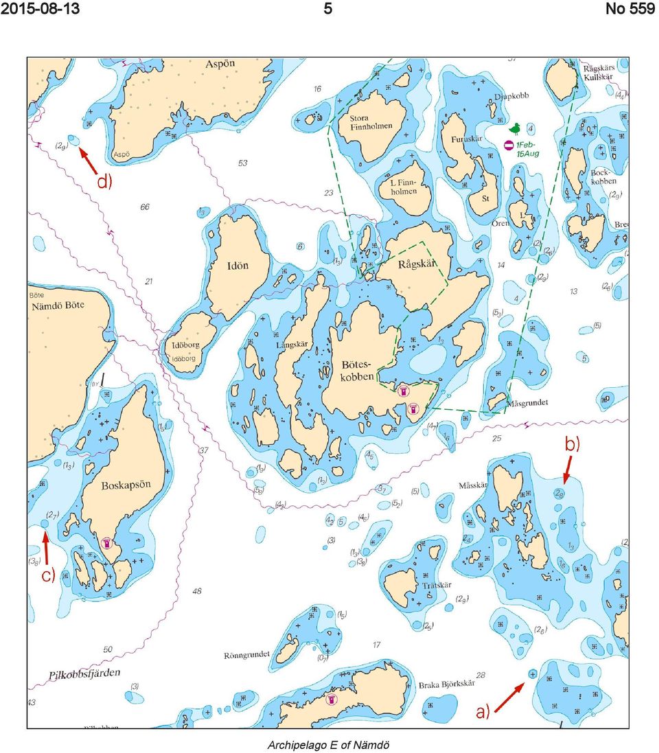
4 No 559 A sewer pipe has been established in Käppala marina. The sewer pipe serving the facility to empty septic tanks that has been established. Insert sewer pipe 59-20,9N ,5E Bsp Stockholm M 2013/s11 Käppala Käppala Båtsällskap Publ. 13 augusti 2015 * Chart: 6144, 6145 Sweden. Northern Baltic. E of Nämdö and Runmarö. Updated information in the depth range 0-3 m. New shoals have been found in the archipelago east of islands Nämdö and Runmarö. Insert underwater rock a) 59-11,13N ,76E SW of Tärnsörarna Insert shoal 2,8 m b) 59-11,74N ,01E E of Måsskär Insert shoal 2,7 m c) 59-11,74N ,60E W of Boskapsön Insert shoal 2,9m d) 59-13,04N ,91E SW of Aspön Insert shoal 3 m e) 59-14,22N ,30E N of St Bäckskär Insert shoal 3,8 m f) 59-14,21N ,46E W of Skötkobben Insert shoal 2,8 m g) 59-14,52N ,68E E of Krokholmen Insert shoal 3 m h) 59-14,51N ,22E W of Granholmen Insert shoal 2,8 m i) 59-15,53N ,98E NE of Långholmen Insert shoal 2,7 m j) 59-15,71N ,78E NNW of Alkobben Insert underwater rock k) 59-14,87N ,02E SW of Lill-Runö Insert shoal 5 m l) 59-15,11N ,96E W of Runö Insert shoal 4 m m) 59-15,32N ,04E SE of Barrskär Insert shoal 2,4 m n) 59-15,57N ,56E E of Halvan Insert shoal 2,2 m o) 59-15,56N ,73E E of Halvan Bsp Stockholm M 2013/s30, s31, s37, s38
 59-11,13N 018-47,76E SW of Tärnsörarna Insert shoal 2,8 m b) 59-11,74N 018-48,01E E of Måsskär Insert shoal 2,7 m c) 59-11,74N 018-44,60E W of Boskapsön Insert shoal 2,9m d)")
5 No 559 Archipelago E of Nämdö
6 No 559 Archiplego SE of Runmarö

7 No 559 Archipelago S of Runmarö Hydrographica. Publ. 6 augusti 2015 * (T) Chart: 616, 6163 Sweden. Northern Baltic. E of Utö. Gunnery exercise. Aug 19-23, Position: Approx N E Utö Firing Danger Area Gunnery exercise will be carried out within Utö firing range. The current extention of the closed area is given in the table. Information during practice times VHF channel 16, call Utö skjutfält, or phone +46 (0) Information about upcoming practice times, phone: Day Time Range from shore Aug M Aug M Aug M Not shown in ENC. Bsp Stockholm S 2013/s18, s37 Försvarsmakten, Utö. Publ. 12 augusti 2015 Lake Mälaren and Södertälje kanal * Chart: 111 Sweden. Lake Mälaren and Södertälje kanal. Lovön. Mörbyfjärden. Underwater rocks. Insert underwater rock a) 59-18,75N ,82E Amend 3 m depth contour b) BSP Mälaren 2014/s49

8 No 559 Underwater rock Sjöfartsverket, Norrköping. Publ. 13 augusti 2015 * Chart: 6141 Sweden. Lake Mälaren and Södertälje kanal. Stockholm. Gröndalsbron. Pile fendering. Expired notices: 2014:517/9902(P), 2015:534/10152(T) Construction of pile fenderings in the passage under Gröndalsbron bridge is completed. Due to this, the temporary restrictions regarding maximum breadth for passing ships is cancelled, as well as the prohibition to pass if visibility is less than 400 m. Insert pile fendering according to chartlet 59-19,1N ,9E Delete text Under construction BSP Mälaren 2014/s50 Bridge Gröndalsbron Sjöfartsverket, Norrköping. Publ. 12 augusti 2015 * (T) Chart: 111 Sweden. Lake Mälaren and Södertälje kanal. Lake Albysjön. Recreational area Flottsbro Friluftsområde. European Championship for Hovercraft. Restricted area. Time: September 4-6, daily between and LT. During the European Championship for Hovercraft an area in the south-eastern part of Albysjön is restricted for all unauthorised vessels. Officiating vessels and units taking part in the event are exempt. Albysjön 59-13,97N ,79E Not shown in ENC. BSP Mälaren 2014/s49

9 No 559 Southern Baltic Time: September 12, LT At the following locations the passing of swimmers can be expected; by the marina at Handelshamnen, Saltösund, Dragöviken, Prästsundet, E of Högaholm and northern part of Långö to the mainland. Not shown in ENC. Bsp Hanöbukten 2014/s40, s42, s43 Albysjön. Restricted area. Länsstyrelsen i Stockholms län. Publ. 13 augusti 2015 * (T) Chart: 7411, 7413 Sweden. Southern Baltic. Karlskrona. Running and swimming event. Marina at Handelshamnen a) 56-10,11N ,58E Saltösund b) 56-09,75N ,17E Dragöviken c) 56-10,20N ,08E Prästsundet d) 56-10,48N ,33E E of Högaholm e) 56-10,51N ,68E Northern part of Långö f) 56-11,00N ,24E
 56-10,11N 015-35,58E Saltösund b) 56-09,75N 015-34,17E Dragöviken c) 56-10,20N 015-34,08E Prästsundet d) 56-10,48N 015-34,33E E of Högaholm e) 56-10,51N")
10 No 559 Swimming event Swimrun 2015 Karlskrona kommun. Publ. 12 augusti 2015 Kattegat * Chart: 8, 92, 93, 931, 9313 Sweden. Kattegat. SW of Göteborg. Light Trubaduren. New character and range. Character and range are amended on Trubaduren main- and subsidiary light as follow. Amend range to 14M 57-35,68N ,98E Trubaduren, main light Amend character and range to Iso R 4s 9M 57-35,68N ,98E Trubaduren, subsidiary light ALL Vol C: 0569 Bsp Västkusten S 2014/s18, s48, s49

11 No 559 Light Trubaduren Sjöfartsverket, Norrköping. Publ. 13 augusti 2015 Skagerrak * Chart: 934 Sweden. Skagerrak. W of Hamburgö and SW of Otterön. Mussel farms. Buoyage. Insert mussel farm a) 58-38,48N ,98E Insert special spar buoy b) 58-38,36N ,33E Insert mussel farm c) 58-33,54N ,48E Insert special spar buoy d) 58-33,55N ,50E Bsp Västkusten N 2014/s11, s13 SW of Otterön
 58-38,48N 011-12,98E Insert special spar buoy b) 58-38,36N 011-13,33E Insert")
12 No 559 W of Hamburgö Saltea AB. Publ. 12 augusti 2015 Lake Vänern and Trollhätte kanal * Chart: 1352, 931 Sweden. Lake Vänern and Trollhätte kanal. River Nordre älv. Kungälv. N of Tjuvholmen. Changes to depths. A hydrographic depth survey has been performed in connection with works done on the northern embankment. New depth contours are shown in updated ENCs and will be included in the next edition of respective chart. Tjuvholmen, Kungälv 57-51,852N ,001E Bsp Göta kanal 2011/s56, Bsp Västkusten S 2014/s62 River Nordre älv - Kungälv Sjöfartsverket, Norrköping. Publ. 13 augusti 2015

Ufs. No 500 2014-06-26. Notices to Mariners, SWEDEN Swedish Maritime Administration. www.sjofartsverket.se
 Ufs No 500 2014-06-26 Notices to Mariners, SWEDEN Swedish Maritime Administration Editorial office Swedish Maritime Administration Ufs/BALTICO 601 78 NORRKÖPING Sweden tel: 0771 630 605 e-mail: ufs@sjofartsverket.se
WATERWAYS in Finland
 WATERWAYS in Finland The efficient and economical running of Finland s vital international transport demands a comprehensive and safe network of fairways. The mission of the Finnish Maritime Administration
Notices to Mariners NR. 18
 Notices to Mariners + OSTEND august 30th 2012 NR. 18 1 FRANCE >18/259 APPROACH NNW ZUYDCOOTE - RESTRICTED AREA - CHART CORRECTION Delete the coordinates of the restricted area between: (a) (b) (c) (d)
Hydrographic Surveying using High Resolution Satellite Images
 Hydrographic Surveying using High Resolution Satellite Images Petra PHILIPSON and Frida ANDERSSON, Sweden Key words: remote sensing, high resolution, hydrographic survey, depth estimation. SUMMARY The
World Vessel Traffic Services Guide - United Kingdom - Port of London
 World Vessel Traffic Services Guide - United Kingdom - Port of London Approaches The Port of London is normally approached using one of three channels. The main Deep Water route is from the North East
1.1 The primary function of the ECDIS is to contribute to safe navigation.
 IMO RESOLUTION A.817 (19) PERFORMANCE STANDARDS FOR ELECTRONIC CHART DISPLAY AND INFORMATION SYSTEMS (ECDIS) Note: The IMO Performance Standards for ECDIS are reproduced in this publication for convenience,
Beacon to Beacon Northern & Southern Maps
 Beacon to Beacon Northern & Southern Maps Disclaimer: When using the Beacon to Beacon Guide booklets and/or the maps contained therein for commercial or non-commercial purposes, the Department of Transport
Final Report RS 2014:01e
 Final Report RS 2014:01e Serious accident at sea on 15 October 2012 involving the vessel Liva Greta at Nockeby Bridge in the County of Stockholm, Sweden. Diary No: S-165/12 2014-03-12 SHK investigates
World Vessel Traffic Services Guide - Australia - Melbourne
 World Vessel Traffic Services Guide - Australia - Melbourne VHF Procedures Port of Melbourne VTS Area is divided into two Sectors. Sector 1: Lonsdale VTS (LVTS) Located at: POINT LONSDALE SIGNAL STATION
KOTKA VTS MASTER'S GUIDE
 1 (5) KOTKA VTS MASTER'S GUIDE Vessel Traffic Services The provisions on vessel traffic services are laid down in the Vessel Traffic Service Act 623/2005 and in the Government Decree on Vessel Traffic
Swedish Search and Rescue Services. Management Mission Co-ordination Mobile Facilities
 Swedish Search and Rescue Services Management Mission Co-ordination Mobile Facilities Administration Organization and Management Swedish Maritime Search and Rescue (SAR) Maritime Policy and Public Affairs
HELLENIC NOTICES TO MARINERS
 HELLENIC NOTICES TO MARINERS Monthly edition 10 31 OCTOBER 2013 Notices 188-203 CONTENTS Page Ι Index of Hellenic Notices to Mariners 3 ΙΙ Notices to Mariners of new Nautical Charts and publications 4
Notices to Mariners. OSTEND MARCH 27th 2014 NR. 07
 Notices to Mariners + OSTEND MARCH 27th 2014 NR. 07 1 >07/118 CANCELLED NOTICES NtM nr. Cancelled Charts 2013-16/258 (T) Approach Western Scheldt - Vicinity Blighbank and Lodewijkbank - ELIA project BelgianOffshore
Classic Fyn Rundt. Sailing Instructions
 Kerteminde Sejlklub Classic Fyn Rundt Sailing Instructions Kerteminde June 3' rd -5 th 2016 DH/IOMR/TEXEL 7 K E R T E M I N D E S E J L K L U B CLASSIC FYN RUNDT Kerteminde Yacht Club June 3 'rd -5 'th
Harbourmaster s Office Operation of Emergency Response Vessels within the Auckland Region. Navigation Safety Operating Requirements 2014
 Harbourmaster s Office Operation of Emergency Response Vessels within the Auckland Region Navigation Safety Operating Requirements 2014 Auckland Council Harbourmaster s Office Operation of Emergency Response
International Maritime Pilots Assoication Association Internationale des Pilotes Maritimes Asociascisn Internacional de Practicos Maritime-portuarios
 International Maritime Pilots Assoication Association Internationale des Pilotes Maritimes Asociascisn Internacional de Practicos Maritime-portuarios INTERNATIONAL MARITIME ORGANIZATION ORGANISATION MARITIME
NEW ZEALAND CHARTING AND NOTICES TO MARINERS
 General Information 1. In accordance with agreements between New Zealand (NZ), Australia (AU) and the British Admiralty (BA) for reducing duplication in charting activities, New Zealand has a defined Charting
London Array. Operations and Maintenance
 London Array londonarray.com London Array Operations & Maintenance Base Port of Ramsgate Military Road Ramsgate CT11 9LG Registered in England and Wales No 04344423 Operations and Maintenance 1 2 Operations
Oregon Administrative Rules Oregon Department of Fish and Wildlife
 DIVISION 023 COLUMBIA RIVER ZONE AND SNAKE RIVER ZONE 635-023-0080 Purpose and Scope (1) The purpose of Division 023 is to provide for management of sport fisheries in the Columbia River Zone and in the
REPUBLIC OF CROATIA MINISTRY OF TOURISM
 REPUBLIC OF CROATIA MINISTRY OF TOURISM NAUTICA New legal regulations Sojourn Tax Act (Official Gazette 152/08 and 59/09 corrigendum) - Frequently asked questions - General 1. What are the advantages of
Information about discontinuation of certain ships routes in the Kattegat from 1 October 2010
 To: See enclosed mailing list 12 July 2010 DANISH MARITIME AUTHORITY Vermundsgade 38 C 2100 Copenhagen Ø DANISH MARITIME SAFETY ADMINISTRATION Overgaden oven Vandet 62 B 1023 Copenhagen K NATIONAL SURVEY
Swedish Law as an Example The Nairobi Convention Summary. Wreck Removal. Jhonnie Kern University of Gothenburg
 Wreck Removal Jhonnie Kern University of Gothenburg 13 October 2015 WRECK REMOVAL Swedish Law as an Example The Nairobi Convention Purposes of the Convention Scope of the Convention Definitions of Ship
Söderströmtunnel: immersion in downtown Stockholm, Sweden
 Söderströmtunnel: immersion in downtown Stockholm, Sweden J. Glückert Dipl.-Ing, Züblin Ground Engineering, Stuttgart, Germany N.H.J. Vink MSe, M. Reijm BSc, P.T. van Westendorp BSc Strukton Immersion
U.S. Statutes Relating to Piracy. (1) In general.--a person who unlawfully and intentionally--
 In general.--a person who unlawfully and intentionally--") U.S. Statutes Relating to Piracy 18 U.S.C. 2280. Violence against maritime navigation (a) Offenses.-- (1) In general.--a person who unlawfully and intentionally-- (A) seizes or exercises control over a
U.S. Statutes Relating to Piracy 18 U.S.C. 2280. Violence against maritime navigation (a) Offenses.-- (1) In general.--a person who unlawfully and intentionally-- (A) seizes or exercises control over a
Law of Ukraine on the exclusive (marine) economic zone of 16 May 1995
 economic zone of 16 May 1995") Page 1 Law of Ukraine on the exclusive (marine) economic zone of 16 May 1995 Taking into consideration the relevant provisions of the 1982 United Nations Convention on the Law of the Sea, Ukraine hereby
Page 1 Law of Ukraine on the exclusive (marine) economic zone of 16 May 1995 Taking into consideration the relevant provisions of the 1982 United Nations Convention on the Law of the Sea, Ukraine hereby
IHO Commission on the Promulgation of Radio Navigational Warning (CPRNW) International Hydrographic Bureau, Monaco
 International Hydrographic Bureau, Monaco") IHO Commission on the Promulgation of Radio Navigational Warning (CPRNW) CPRNW9-3.2.1-V International Hydrographic Bureau, Monaco Origin: Brazil MSI Self Assessment - NAVAREA V Submitted by: Brazil 1.
IHO Commission on the Promulgation of Radio Navigational Warning (CPRNW) CPRNW9-3.2.1-V International Hydrographic Bureau, Monaco Origin: Brazil MSI Self Assessment - NAVAREA V Submitted by: Brazil 1.
REPORT Dry cargo ship STEEL QUEEN - PBDM grounding on 20 March 2005
 Dry cargo ship STEEL QUEEN - PBDM grounding on 20 March 2005 2005-04-15 Dry Cargo Ship -STEEL QUEEN - PBDM grounding on 20 March 2005 Our reference: 080202-05-15553 Maritime Casualty Sten Anderson Investigation
Notices to Mariners. OSTEND AUGUST 28th 2014 NR. 18
 Notices to Mariners + OSTEND AUGUST 28th 2014 NR. 18 1 >18/255 GENERAL NOTICE - PRELIMINARY ANNOUCEMENT OF NEW PUBLICATION Chart 104 Westerschelde - Zeeschelde: Monding Westerschelde tot monding Rupel
Maritime and Coastguard Agency LogMARINE INFORMATION NOTE
 Maritime and Coastguard Agency LogMARINE INFORMATION NOTE MIN 499 (M+F) Wreck Removal: Liability and Compulsory Insurance for the locating, marking and removing of wrecks Notice to all ship owners, operators,
Removal of Wrecks Directive 2015
 Removal of Wrecks Directive 2015 Directive 01-2015 The Director of the Department of Marine Services and Merchant Shipping (ADOMS), in exercise of the powers conferred by Section 7, sub-section (3) of
Southwick Conservation Commission
 1.0 Jurisdiction 1.1 The (Town) annual permitting program is authorized pursuant to 310 CMR 9.07(3) and the DEP letter to the dated January 13, 2010. In the event of any discrepancy between these guidelines
The Paddle Steamer Eric Nordevall II 2010 edition 2
 Background The Association Forsvik Shipyard a non-profit organization was founded in 1995 with the aim of building the paddle steamer Eric Nordevall II. The paddle steamer will be a replica of Eric Nordevall,
HYDROGRAPHIC DEPARTMENT MARITIME AND PORT AUTHORITY OF SINGAPORE (MPA) (Version: July 2015)
 (Version: July 2015)") HYDROGRAPHIC DEPARTMENT MARITIME AND PORT AUTHORITY OF SINGAPORE (MPA) (Version: July 2015) GENERAL SPECIFICATIONS FOR THE CONDUCT OF HYDROGRAPHIC SURVEYS 1 Engagement of Commercial Hydrographic Surveyor
HYDROGRAPHIC DEPARTMENT MARITIME AND PORT AUTHORITY OF SINGAPORE (MPA) (Version: July 2015) GENERAL SPECIFICATIONS FOR THE CONDUCT OF HYDROGRAPHIC SURVEYS 1 Engagement of Commercial Hydrographic Surveyor
IMO ROUTEING OF SHIPS, SHIP REPORTING AND RELATED MATTERS
 INTERNATIONAL MARITIME ORGANIZATION E IMO SUB-COMMITTEE ON SAFETY OF NAVIGATION 51st session Agenda item 3 NAV 51/3/6 3 March 2005 Original: ENGLISH ROUTEING OF SHIPS, SHIP REPORTING AND RELATED MATTERS
Guidance on vessel traffic services (VTS) in Danish waters
 in Danish waters") Translation. Only the Danish document has legal validity. Guidance no. 9680 of 16 December 2010 issued by the Danish Maritime Authority Guidance on vessel traffic services (VTS) in Danish waters Purpose
Translation. Only the Danish document has legal validity. Guidance no. 9680 of 16 December 2010 issued by the Danish Maritime Authority Guidance on vessel traffic services (VTS) in Danish waters Purpose
IMO. RESOLUTION A.817(19) adopted on 23 November 1995 PERFORMANCE STANDARDS FOR ELECTRONIC CHART DISPLAY AND INFORMATION SYSTEMS (ECDIS)
 adopted on 23 November 1995 PERFORMANCE STANDARDS FOR ELECTRONIC CHART DISPLAY AND INFORMATION SYSTEMS (ECDIS)") INTERNATIONAL MARITIME ORGANIZATION E IMO A 19/Res.817 15 December 1996 Original: ENGLISH ASSEMBLY 19th session Agenda item 10 RESOLUTION A.817(19) adopted on 23 November 1995 PERFORMANCE STANDARDS FOR
INTERNATIONAL MARITIME ORGANIZATION E IMO A 19/Res.817 15 December 1996 Original: ENGLISH ASSEMBLY 19th session Agenda item 10 RESOLUTION A.817(19) adopted on 23 November 1995 PERFORMANCE STANDARDS FOR
Seil Sound, Argyll UKS799231 Last Edited 01/06/11 Page 1. Seil Sound, Argyll. Report Reference Number 31
 31 Seil Sound, Argyll Name Seil Sound, Argyll Report Reference Number 31 WFD Code UKS7992331 Local Information An area bounded by the lines drawn between the points NM7641714700 (Rubha na Moine) and NM7787814700
Passenger Terminal Amsterdam
 Fact sheet large cruise ships to Passenger Terminal Amsterdam Port of Amsterdam Amsterdam-IJmond Pilot Organization 2009 Version: November 6 th 2009 This fact sheet provides information on the passage
Marine Accidents SØULYKKESRAPPORT FRA OPKLARINGSENHEDEN
 Marine Accidents 2009 SØULYKKESRAPPORT FRA OPKLARINGSENHEDEN The Danish Maritime Authority 2009, Vermundsgade 38C, 2100 Copenhagen Ø Telephone 39 17 44 00 - Fax 39 17 44 01 www.sofartsstyrelsen.dk sfs@dma.dk
GUIDELINES AND CRITERIA FOR VESSEL TRAFFIC SERVICES ON INLAND WATERWAYS (VTS Guidelines 2006)
") GUIDELINES AND CRITERIA FOR VESSEL TRAFFIC SERVICES ON INLAND WATERWAYS (VTS Guidelines 2006) 1. INTRODUCTION 1.1 These Guidelines are compatible with SOLAS regulation V/8-2 and IMO Assembly Resolution
GUIDELINES AND CRITERIA FOR VESSEL TRAFFIC SERVICES ON INLAND WATERWAYS (VTS Guidelines 2006) 1. INTRODUCTION 1.1 These Guidelines are compatible with SOLAS regulation V/8-2 and IMO Assembly Resolution
Mandatum Life Helsinki-Tallinna Race 2013 SAILING INSTRUCTIONS
 1. RULES 1.1. Governing rules and definitions The race will be governed by the rules as defined in the Racing Rules of Sailing 2013-2016 (RRS) including the FinLYS Rule with the exceptions mentioned in
How To Navigate The Ocean In The Pacific Coastline
 BookletChart El Segundo and Approaches NOAA Chart 18748 A reduced-scale NOAA nautical chart for small boaters When possible, use the full-size NOAA chart for navigation. Published by the National Oceanic
ORDINANCE NO.: 2008-01
 ORDINANCE NO.: 2008-01 AN ORDINANCE OF THE BOARD OF HERNANDO COUNTY COMMISSIONERS CREATING A SECfION OF THE HERNANDO COUNTY CODE RELATING TO THE MOORING OR DOCKING OF COMMERCIAL VESSELS AS DEFINED; PROVIDING
MARINE HULL GLOBAL TRADING LIMITS
 MARINE HULL GLOBAL TRADING LIMITS A study of the Institute warranties 1976, American Institute Trade Warranties (1972) and International Navigating Conditions (2003). During this inter-active presentation,
Introduction to AIS White Paper
 Introduction to AIS White Paper 1. Background AIS (Automatic Identification System) is the mariner s most significant development in navigation safety since the introduction of radar. The system was originally
Small Craft Used Exclusively for Pleasure Navigation
 ECONOMIC COMMISSION FOR EUROPE INLAND TRANSPORT COMMITTEE Working Party on Inland Water Transport Geneva Small Craft Used Exclusively for Pleasure Navigation Resolution No. 41 UNITED NATIONS New York and
DEPARTMENT OF MARINE SERVICES AND MERCHANT SHIPPING (ADOMS) Boatmaster s Licenses
 Boatmaster s Licenses") CIRCULAR Local 2013-001 DEPARTMENT OF MARINE SERVICES AND MERCHANT SHIPPING (ADOMS) Boatmaster s Licenses Ref SCV Code. Companies operating SCV certificated vessels under the flag of Antigua and Barbuda.
CIRCULAR Local 2013-001 DEPARTMENT OF MARINE SERVICES AND MERCHANT SHIPPING (ADOMS) Boatmaster s Licenses Ref SCV Code. Companies operating SCV certificated vessels under the flag of Antigua and Barbuda.
THESE INSTRUCTIONS ARE INTENDED FOR MARINERS CARRYING OUT THE IHO ENC/ECDIS DATA PRESENTATION AND PERFORMANCE CHECKS
 THESE INSTRUCTIONS ARE INTENDED FOR MARINERS CARRYING OUT THE IHO ENC/ECDIS DATA PRESENTATION AND PERFORMANCE CHECKS The checks and the accompanying dataset are not intended for, and are not suitable to
E-navigation, process, results, status and delivery
 E-navigation, process, results, status and delivery Chile, October 2013 John Erik Hagen, Regional Director NCA Coordinator of IMO Correspondence Group on e-navigation Shipping moves into the digital world
Code of conduct Safe on-water conduct on the Brisbane River
 Code of conduct Safe on-water conduct on the Brisbane River Introduction The safe operation of passive craft on Queensland s waterways is a priority for state and local government authorities, commercial
BookletChart. San Francisco Bay Southern Part NOAA Chart 18651. A reduced-scale NOAA nautical chart for small boaters
 BookletChart San Francisco Bay Southern Part NOAA Chart 18651 A reduced-scale NOAA nautical chart for small boaters When possible, use the full-size NOAA chart for navigation. Included Area Published by
Audit of Port Marine Safety Code compliance
 DUCHY OF CORNWALL ST MARY S HARBOUR Audit of Port Marine Safety Code compliance October 15 Marine Safety Management System by sections 1. POLICY Policy Development and Communication Approved by the Board
Regulation concerning the prevention of transfer of alien organisms via ballast water and sediments from ships (the Ballast Water Regulation)
") Regulation concerning the prevention of transfer of alien organisms via ballast water and sediments from ships (the Ballast Water Regulation) Laid down by the Ministry of the Environment on 7 July 2009
Regulation concerning the prevention of transfer of alien organisms via ballast water and sediments from ships (the Ballast Water Regulation) Laid down by the Ministry of the Environment on 7 July 2009
REHABILITATION AND EXTENSION PROJECT FOR PORT OF LOBITO
 REHABILITATION AND EXTENSION PROJECT FOR PORT OF LOBITO Advantages of Port Lobito (1) Predominant geological locations Facing the Atlantic, Port Lobito locates around 30km north to Beguela City, and it
Welcome to Göteborg Open sea Race, 2015.
 Welcome to Göteborg Open sea Race, 2015. Notice of Race. Event: Göteborg Open Sea Race Date: August 7 8, 2015. Organizer: Göteborg Quinnliga Segelsällskap (GQSS) 1. RULES 1.1 The regatta will be governed
THE JONES ACT ONE MORE VARIABLE IN THE OFFSHORE WIND EQUATION
 THE JONES ACT ONE MORE VARIABLE IN THE OFFSHORE WIND EQUATION By Douglas Burnett and Michael Hartman 1 Of the many pieces to the offshore wind puzzle for the United States, the Jones Act and other statutory
Statistical Summary Marine Occurrences 2013
 Statistical Summary Marine Occurrences 2013 Foreword This document provides Canadians with an annual summary of selected maritime safety data. It covers commercial vessels, which include all vessels registered
NSW MARINE PILOTAGE CODE VOLUME ONE GENERAL
 NSW MARINE PILOTAGE CODE VOLUME ONE GENERAL Revised 23 October 2015 TABLE OF CONTENTS NSW MARINE PILOTAGE CODE VOLUME ONE GENERAL Contents NSW MARINE PILOTAGE CODE VOLUME ONE GENERAL... 2 PART 1 PRELIMINARY...
CODES OF CONDUCT FOR VESSELS AND CRAFT USING THE CATTEWATER
 PORT OF PLYMOUTH CATTEWATER HARBOUR COMMISSIONERS 2 The Barbican, Plymouth, PL1 2LR Tel: 01752 665934 Fax: 01752 253624 e-mail: info@plymouthport.org.uk PLYMOUTH PILOTAGE SERVICE 2 The Barbican, Plymouth,
TANZANIA HARBOURS AUTHORITY PO Box 9184 DAR-ES-SALAAM TANZANIA
 TANZANIA HARBOURS AUTHORITY PO Box 9184 DAR-ES-SALAAM TANZANIA Phone: +255 22 211 0401 Fax: +255 22 211 3938 E-mail: dg@tanzaniaports.com Website: www.tanzaniaports.com The Tanzania Harbours Authority
1. SLACK TIDES refer to tide with strength not exceeding 0.5 knots.
 DEFINITIONS 1. SLACK TIDES refer to tide with strength not exceeding 0.5 knots. 2. SLACK WATER refers to the interval when the strength of the tidal stream is very weak or at zero knots. This is usually
Industry Recommendations for ECDIS Familiarisation
 ECDIS November 2012 Industry Recommendations for ECDIS Familiarisation Background Being aware that the implementation of Electronic Chart Display and Information Systems (ECDIS) has given rise to confusion
Swedish Search and Rescue Services. Management Mission Co-ordination
 Swedish Search and Rescue Services Management Mission Co-ordination Mobile Facilities Administration Co-ordination and Management Maritime and Aeronautical SAR Service Organization in the Swedish Maritime
Emergency Response Plan. at sea also valid in case of Flooding, where applicable
 Plan 1. Grounding, Stranding at sea also valid in case of Flooding, where applicable 2. Application Shorebased Organisation All Ships prepared: approved: released: Revision 0 HLS Management 2006-11-24
CONCEPT FOR ACTIVITY 1: DYNAMIC & PROACTIVE ROUTES OR GREEN-ROUTES
 TEN-T PROJECT NO: 2010-EU-21109-S CONCEPT FOR ACTIVITY 1: DYNAMIC & PROACTIVE ROUTES OR GREEN-ROUTES January 2012 TABLE OF CONTENTS 1 INTRODUCTION... 3 1.1 Scope and purpose... 3 1.2 Objectives and expected
RYA Guide to the River Medina
 RYA Guide to the River Medina Past the hustle and bustle of Cowes on the Isle of Wight, the upper reaches of the Medina River often go unexplored. But it offers with great waterside pubs, a clench of interesting
STATUTORY INSTRUMENT. No. of 2007. Merchant Shipping (Safe Ship Management Systems) Regulation 2007. ARRANGEMENT OF SECTIONS.
 Regulation 2007. ARRANGEMENT OF SECTIONS.") STATUTORY INSTRUMENT. No. of 2007. Merchant Shipping (Safe Ship Management Systems) Regulation 2007. ARRANGEMENT OF SECTIONS. PART I. INTRODUCTION. 1. Interpretation accident Act approved safe ship management
STATUTORY INSTRUMENT. No. of 2007. Merchant Shipping (Safe Ship Management Systems) Regulation 2007. ARRANGEMENT OF SECTIONS. PART I. INTRODUCTION. 1. Interpretation accident Act approved safe ship management
AIS Overview. Evans Starzinger
 AIS Overview by Evans Starzinger Background AIS (Automatic Identification System) is a VHF radio system which automatically communicates vessel information (vessel identity, position, speed, etc) between
Merchant Shipping (Registration, etc) Act 1993 Instructions to Surveyors Tonnage Measurement of Ships Revised Chapter 11 -Registration
 Act 1993 Instructions to Surveyors Tonnage Measurement of Ships Revised Chapter 11 -Registration") MERCHANT SHIPPING NOTICE No. M.1675 Merchant Shipping (Registration, etc) Act 1993 Instructions to Surveyors Tonnage Measurement of Ships Revised Chapter 11 -Registration Notice to Shipowners, Masters,
MERCHANT SHIPPING NOTICE No. M.1675 Merchant Shipping (Registration, etc) Act 1993 Instructions to Surveyors Tonnage Measurement of Ships Revised Chapter 11 -Registration Notice to Shipowners, Masters,
Piers, Wharves & Docks
 Piers, Wharves & Docks Exposures and Concerns By: Christopher L. Pesce May 10, 2011 Piers, Wharves & Docks Statistics Why underwriters love to write docks Estimated industry losses for 2010: $30,000,000
Failing Coastal Wood Infrastructure on the Great Lakes
 University of Wisconsin Sea Grant Institute Contact Gene Clark grclark@aqua.wisc.edu 715-392-3246 Failing Coastal Wood Infrastructure on the Great Lakes Gene Clark/UW Sea Grant Institute Introduction Many
Trade Show Prospectus 3-6 PM, January 29, 2015 Moore Building SC State Fairgrounds
 Trade Show Prospectus 3-6 PM, January 29, 2015 Moore Building SC State Fairgrounds Show Date, Time, Place, Show Colors Thursday, January 29, 2015 3:00-6:00 p.m. - Exhibit Hours Moore Building, South Carolina
Using the ADMIRALTY Vector Chart Service with PC Maritime ECDIS. This guide is based on the PC Maritime NAVMASTER ECDIS Version 7.1.0.
 Using the ADMIRALTY Vector Chart Service with PC Maritime ECDIS This guide is based on the PC Maritime NAVMASTER ECDIS Version 7.1.0.16 User Guide V1.1 2 1 Introduction 3 2 Data Management 4 3 The User
MARINE INSURANCE CONDITIONS COVERING LOSS OF INCOME OF SEA-GOING VESSELS
 These clauses are for illustrative purposes only and different terms and conditions may be agreed in particular where any clause excludes losses or makes cover subject to certain conditions. MARINE INSURANCE
GUIDANCE NOTES ON RISK ASSESSMENT FOR EVENTS IN HARBOUR AUTHORITY AREAS NOTIFICATION AND STANDARD EVENT PLANNING RISK ASSESSMENT GUIDANCE NOTE
 GUIDANCE NOTES ON RISK ASSESSMENT FOR EVENTS IN HARBOUR AUTHORITY AREAS NOTIFICATION AND STANDARD EVENT PLANNING RISK ASSESSMENT GUIDANCE NOTE The DfT (Department for Transport) Port Marine Safety Code
Cruise Shipping Policy for the Great Barrier Reef Marine Park
 for the Great Barrier Reef Marine Park October 1999 Contents SUMMARY OF S...1 INTRODUCTION... 2 MANAGEMENT OVERVIEW... 3 ACT AND REGULATIONS... 3 ZONING PLANS... 3 Far Northern Section... 3 Cairns Section...
LAW No. 57. Of 6 August 2008. The General Merchant Marine THE NATIONAL ASSEMBLY DECREES: Title I. Enrollment. Chapter I. Registration of Vessels
 LAW No. 57 Of 6 August 2008 The General Merchant Marine THE NATIONAL ASSEMBLY DECREES: Title I Enrollment Chapter I Registration of Vessels Section 1 General Provisions Article 1. The registration of a
Development of Oil Combating in the Gulf of Bothnia
 Development of Oil Combating in the Gulf of Bothnia BRISK Final Seminar Marina Congress Centre, Helsinki 8 December 2011 Jorma Rytkönen Finnish Environment Institute (SYKE) / Marine Pollution Response
Safe carriage of oil in extreme environments
 Safe carriage of oil in extreme environments Stena Aframax. 117,100 DWT. Swedish-Finnish Ice Class 1A Super Stena Panamax. 74,999 DWT. Swedish-Finnish Ice Class 1A Stena P-MAX. 49,900 DWT. Swedish-Finnish
U.S. Coast Guard. America s Maritime Guardian
 U.S. Coast Guard America s Maritime Guardian Nov. 2009 A few armed vessels, judiciously stationed at the entrances of our ports, might at a small expense be made useful sentinels of the laws. Alexander
SUMMARY: The Coast Guard is establishing a temporary safety zone within the Coast Guard
 This document is scheduled to be published in the Federal Register on 06/23/2016 and available online at http://federalregister.gov/a/2016-14908, and on FDsys.gov 9110-04-P DEPARTMENT OF HOMELAND SECURITY
DNVGL-RU-0050 Edition October 2014
 RULES FOR CLASSIFICATION DNVGL-RU-0050 Edition October 2014 The content of this service document is the subject of intellectual property rights reserved by ( DNV GL ). The user accepts that it is prohibited
IDNM Nr.17 Nr. 203 216 / 2015 April 17 th 2015 SECTION I
 SECTION I EXPLANATORY NOTES. NOTICE TO MARINERS GUIDANCE 1. Indonesian Notices to Mariners using dual languages Indonesian and English. 2. Asterisk (*) Indicates that Notices to Mariners are based on original
INVESTIGATION OF THE GROUNDING OF MV FULL CITY IMO No. 9073672 AT SASTEIN JULY 31st 2009
 1 PRELIMINARY REPORT INVESTIGATION OF THE GROUNDING OF MV FULL CITY IMO No. 9073672 AT SASTEIN JULY 31st 2009 Released August 26th 2009 INTRODUCTION At 0044 hrs local time on July 31st the Accident Investigation
SEA Europe input on future EU-US Transatlantic Trade and Investment Partnership
 SEA Europe input on future EU-US Transatlantic Trade and Investment Partnership SEA Europe is the Association for Ships and Maritime Equipment. Originating from the fusion of EMEC, the European Marine
Chairman s Decision No. (37) of 2013 concerning the licensing, hire, and usage of Personal Watercrafts (Jet Ski)
 of 2013 concerning the licensing, hire, and usage of Personal Watercrafts (Jet Ski)") Date: /7/2013 Chairman s Decision No. (37) of 2013 concerning the licensing, hire, and usage of Personal Watercrafts (Jet Ski) Chairman:- Having reviewed: - law No. (1) of 1974 concerning the reorganization
Date: /7/2013 Chairman s Decision No. (37) of 2013 concerning the licensing, hire, and usage of Personal Watercrafts (Jet Ski) Chairman:- Having reviewed: - law No. (1) of 1974 concerning the reorganization
ASA 105: Coastal Navigation Curriculum
 (784) 456-9526 www.barefootoffshore.com info@barefootoffshore.com ASA 105: Coastal Navigation Curriculum Prerequisites: None General Description: Able to demonstrate the navigational theory required to
27. SEA CHARTS EXERCISES ADMIRALTY GUIDE TO ELECTRONIC CHARTING
 27. SEA CHARTS EXERCISES ADMIRALTY GUIDE TO ELECTRONIC CHARTING 1. Supply the correct multi-word term from those in the brackets: (Electronic Navigational Charts, marine survey data, route planning, positioning
AYAK GUIDE ISLAND STATE PARKS. NEW YORK STATE George E. Pataki, Governor
 AYAK & C KAYAK AYAK & CANOE GUIDE TO LONG ISLAND STATE PARKS NEW YORK STATE George E. Pataki, Governor NEW YORK STATE OFFICE OF PARKS, RECREATION AND HISTORIC PRESERVATION Bernadette Castro, Commissioner
Maritime and Coastguard Agency LogMARINE INFORMATION NOTE
 Maritime and Coastguard Agency LogMARINE INFORMATION NOTE MIN 498 (M) Seafarer Training and Certification: Using Yacht Sea Service Towards Unlimited Merchant Navy Certificates of Competency Applications
Passage Planning made efficient and cost-effective
 Passage Planning made efficient and cost-effective Captain Sam Mead, Shell UK Ltd 1. Abstract The purpose of this paper is to describe how the Shell UK Coastal Fleet determined its criteria and principles
ACQUIRING MINERAL RIGHTS IN THE NORTHWEST TERRITORIES
 ACQUIRING MINERAL RIGHTS IN THE NORTHWEST TERRITORIES Introduction Establishing and maintaining strong working relationships between the mineral industry and Northwest Territories (NWT) residents and community
Section A: Ship s Details
 MSD/MRCS/004/2012 Application Form for a Ship Station Licence (applicable only to SOLAS ships) With regard to radiocommunications equipment, in terms of the Electronic Communications (Regulation) Act (Cap.399),
Notice of Annual General Meeting
 Notice of Annual General Meeting Notice is hereby given that the Annual General Meeting of will be held at SKF Kristinedal, Byfogdegatan 4, Göteborg, Sweden, at 14.30 on Thursday, 28 April 2011. The doors
Annex IV of MARPOL 73/78. Regulations for the Prevention of Pollution by Sewage from Ships
 Annex IV of MARPOL 73/78 Regulations for the Prevention of Pollution by Sewage from Ships Annex IV of MARPOL 73/78* Regulations for the Prevention of Pollution by Sewage from Ships Regulation 1 Definitions
LP News. New ECDIS mandatory requirements Part 2: A key to safe operation UK P&I CLUB
 UK P&I CLUB LP News MARCH 2011 New ECDIS mandatory requirements Part 2: A key to safe operation The mandatory requirement and introduction of electronic chart display and information systems is seen as
Florida Lawmakers Amend Vessel Safety Regulations
 Anchoring Restrictions Florida Lawmakers Amend Vessel Safety Regulations In May 2005, the City of Miami Beach joined a number of other Florida municipalities in passing ordinances to regulate anchoring
SECTION II CORRECTIONS TO C. G. LIGHT LIST, VOLUME I ATLANTIC COAST,
 CORRECTIONS TO C. G. LIGHT LIST, VOLUME I ATLANTIC COAST, 2013 625 15980 Narragansett-Buzzards Bay Approach Lighted Whistle Buoy A 15495 - Daybeacon 2 41-27-33.93N 70-35-25.46W 15980 625 Narragansett-Buzzards
Baltic Marine Environment Protection Commission
 Baltic Marine Environment Protection Commission Helsinki Commission Helsinki, Finland, 3-4 March 2015 HELCOM 36-2015 Document title Special Report from a Cruise - Great Inflow to the Baltic Sea Code 6-1
Notice to all Ship Owners and Operators; Masters, and Deck Officers of Merchant Ships; Manufacturers, and Suppliers of Voyage Data Recorders.
 MARINE GUIDANCE NOTE MGN 272 (M) VOYAGE DATA RECORDER S (VDRs) PERFORMANCE TESTING Notice to all Ship Owners and Operators; Masters, and Deck Officers of Merchant Ships; Manufacturers, and Suppliers of