ArcGIS for Mobile Solution. Harkeerat Kang GIS Specialist Senior King County May 14 th, 2014 WAURISA Conference, 2014
|
|
|
- Josephine Hancock
- 7 years ago
- Views:
Transcription
1 ArcGIS for Mobile Solution Harkeerat Kang GIS Specialist Senior King County May 14 th, 2014 WAURISA Conference, 2014

2 What is Mobile GIS Extends GIS beyond the office Allows staff to collect data, inspect and maintain data in the field

3 ArcPad Mobile Solutions ArcGIS for Windows Mobile Collector for ArcGIS Handheld receivers with proprietary software Smartphone apps non Esri

4 Licensing One mobile deployment is included with each ArcGIS for Desktop license Or buy additional mobile deployments in 5 or 50 packs

5 Architecture Option Server ArcGIS Server ArcSDE ArcGIS Mobile

6 Software installation Mobile Project Center ArcGIS Mobile

7 Mobile Workflow 1. Build mobile geodatabase 2. Author mobile map 3. Publish mobile service 4. Customize mobile project 5. Deploy mobile project

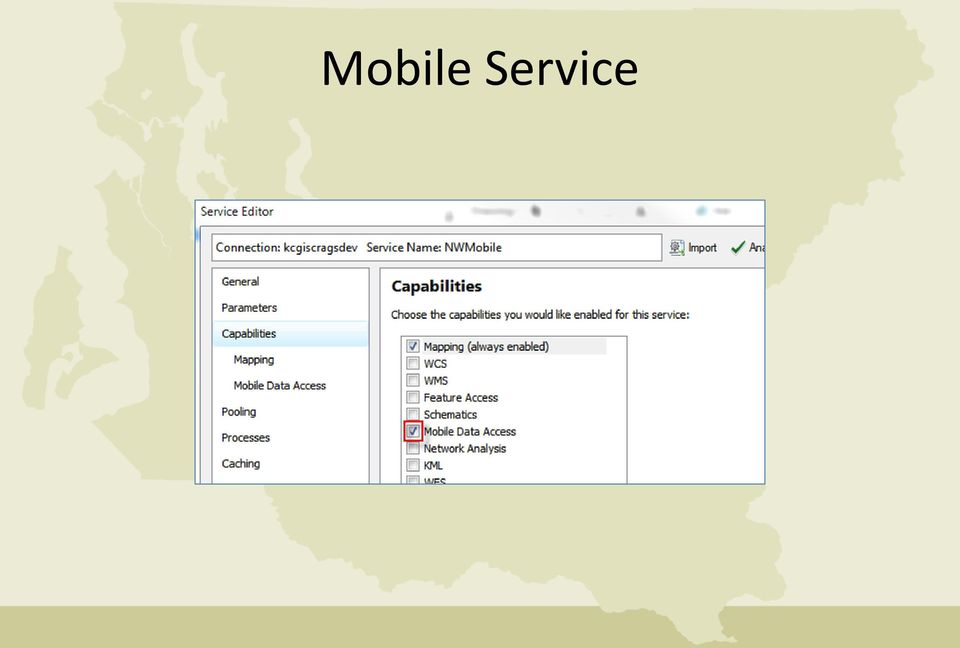
8 Mobile Service
9 Environment Connected: basemap and mobile service layer caches are not needed, data synchronized in the field Disconnected: need access to a mobile cache and map cache on the devices

10 Project Map Layers/Services Basemap Operational layers

11 Mobile Basemap Types Basemap type Data type Connectivity Notes Cached map tiles ArcGIS Server map services Image tiles conf.xml file conf.cdi file Disconnected Reference the folder that stores the conf.xml file Service URL Connected Use any security credentials that apply to the service ArcGIS.com Service URL Connected Operational data must use the same reference as ArcGIS.com service Street map for Mobile Tile packages and tiled datasets Vector based.sdc files.navmap schema file Disconnected Reference the folder that stores the.navmap file.tpk extension Disconnected Inside a tile package is a tiled dataset

12 Caches Map Cache: are image tiles created from the map service Mobile Cache: are local copies of the map schema and the operational data for the mobile project

13 Deployment Models Disconnected no connectivity Nomadic partially connected environment, server load increases On-demand complete connected environment, server load is high

14 Mobile Project Center

15 Mobile Project Center

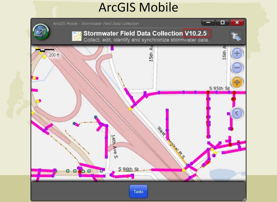
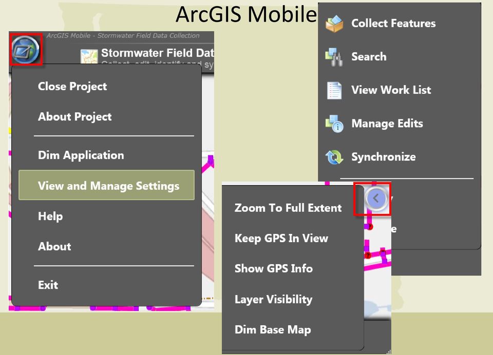
16 ArcGIS Mobile
17 ArcGIS Mobile
18 Deployment Folder structure of mobile project deployment should be consistent Store map caches and mobile caches correctly Update deployment files with schema updates Synchronize data before disconnecting devices Basemap map cache updates are infrequent

19 Folder Structure

20 Data Synchronization Use two databases for Office editing Mobile field data collection Use replication Synchronize data daily

21 Stormwater Datasets
22 Equipment Lenovo Thinkpad Helix tablet running ArcGIS Mobile 10.2 Intel Core i7-3667u 2.00 GHz processor 8.00 GB RAM 64 bit Windows 8 Operating System 256 GB storage Bluetooth and Docking Station Trimble GPS Pathfinder ProXT Garmin Glow GPS
23 Supported Devices ArcPad ArcGIS for Windows Mobile Collector for ArcGIS Smartphones N N Y Tablets, Laptops Y Y Tablets - Y Operating Systems Windows Mobile 5, 6, Vista, 7, 8 Network Connectivity Windows Mobile 5, 6 Windows XP, Vista, 7 Android and ios Wi-FI, Cell, Bluetooth Y Y Y In-Field Functionality Task and Workflow Driven N Y Y Disconnected Editing Y Y Y Ad Hoc Data Collection Y N N Editing of Layer Display Properties Y N N Map Services Y Y Y ArcGIS Online Services Y Y Y Customization ArcPad Studio ArcGIS Runtime SDK for Windows Mobile License Fee Y Free with ArcGIS Desktop license Comes with Organization ArcGIS Online account N
24 Best Practices Use GDB aliases and domains Use saved extents for mobile caching Use ESRI optimized symbology, scale dependencies, map extents Use minimum layers to be edited in a project If possible use disconnected environment for fast data collection
25 Benefits of ArcGIS for Mobile Rapidly deploy field GIS applications without custom development Offline (a.k.a. disconnected ) data collection Collect attachments One service, many clients Replace paper-based workflows Make timely and informed decisions
26 ArcGIS for Mobile Challenges GPS accuracy requires extra equipment, processes Limited user interface customization Imagery base maps storage size Standard field computer hassles (battery, rain, software/hardware glitches, etc.) Table relationships are not supported Related tables are not supported No ad hoc data collection Cannot modify symbology in the field
27
28 Upcoming Changes ArcGIS for Mobile will be replaced by Collector for ArcGIS
29 Thank you! Harkeerat Kang
Making Your Mobile Workforce More Efficient
 ArcGIS for Mobile Making Your Mobile Workforce More Efficient What Is Mobile GIS? Mobile geographic information system (GIS) technology extends GIS beyond the office and allows organizations to make accurate,
Making Your Mobile Workforce More Efficient
 ArcGIS for Mobile Making Your Mobile Workforce More Efficient What Is Mobile GIS? Mobile geographic information system (GIS) technology extends GIS beyond the office and allows organizations to make accurate,
ESRI Mobile GIS Solutions Overview. Shane Clarke ESRI
 ESRI Mobile GIS Solutions Overview Shane Clarke ESRI Agenda Overview of mobile GIS ESRI mobile GIS Solutions Selecting a mobile GIS solution Q & A 2 Mobile GIS Overview 3 What is mobile GIS? Extension
Esri s ArcPad vs. ArcGIS Mobile vs. Trimble s TerraSync vs. TerraFlex Comparison By: Electronic Data Solutions
 Esri s ArcPad vs. ArcGIS Mobile vs. Trimble s TerraSync vs. TerraFlex Comparison By: Electronic Data Solutions ArcPad is mobile field mapping and data collection software designed for GIS professionals.
Mobile Solutions in ArcGIS. Justin Fan
 Mobile Solutions in ArcGIS Justin Fan Agenda Introducing Mobile GIS Esri Mobile GIS solutions Selecting the right Mobile GIS solution Resources Q&A Introducing Mobile GIS What is Mobile GIS? Extends the
Mobile Solutions for Data Collection. Sarah Croft and Laura Pierik
 Mobile Solutions for Data Collection Sarah Croft and Laura Pierik Presentation Overview Project Overview Benefits of using Mobile Technology Mobile Solutions- two different approaches Results and Recommendations
Implementing a Mobile GIS. Tom Brenneman Esri
 Implementing a Mobile GIS Tom Brenneman Esri Agenda Mobile GIS Overview ESRI Mobile GIS Solutions - ArcPad - ArcGIS Mobile - ArcGIS for ios Select a Mobile GIS Solution Q&A Mobile GIS Overview ArcGIS 10
White Paper. Freeance Mobile for Cityworks
 White Paper Freeance Mobile for Cityworks Version 1.1 May 2012 Freeance Mobile for Cityworks Freeance Mobile for Cityworks 2012.1 is a mobile application for the following smartphones and tablets: iphone
Portal for ArcGIS. Satish Sankaran Robert Kircher
 Portal for ArcGIS Satish Sankaran Robert Kircher ArcGIS A Complete GIS Data Management Planning & Analysis Field Mobility Operational Awareness Constituent Engagement End to End Integration Collect, Organize,
The advantages of high accuracy GIS field data collection in the Transportation Industry. MGIS Overview Sergio Hernández
 The advantages of high accuracy GIS field data collection in the Transportation Industry. MGIS Overview Sergio Hernández The big question: Where are our assets? Where do we need improvements? WHERE? Where
ESRI and Xplore Technologies 2008 Mobile Government Demonstration Project Grant Program Final Report
 ESRI and Xplore Technologies 2008 Mobile Government Demonstration Project Grant Program Final Report Introduction and Project Purpose The ESRI and Xplore Technologies Mobile Government Demonstration Project
GIS Architecture and Data Management Practices Boone County GIS Created and Maintained by the Boone County Planning Commission GIS Services Division
 GIS Architecture and Data Management Practices Boone County GIS Created and Maintained by the Boone County Planning Commission June 2008 Background Boone County s GIS program has been in existence for
Android Tablet GIS Solution Transforms Well Inspection for Bucks County Health Department
 Android Tablet GIS Solution Transforms Well Inspection for Bucks County Health Department A Case Study Problem Statement The Bureau of Environmental Health (BEH) within the Bucks County Health Department
A Workflow for Creating and Sharing Maps
 A Workflow for Creating and Sharing Maps By Keith Mann, Esri What You Will Need Item Source ArcGIS Online for Organizations subscription ArcGIS 10.1 for Desktop (Any license level) ArcGIS Spatial Analyst
Building Applications with ArcGIS Runtime SDK for ios Part II. Eric Ito and Scott Sirowy
 Building Applications with ArcGIS Runtime SDK for ios Part II Eric Ito and Scott Sirowy Building Applications with ArcGIS Runtime SDK for ios Part II Eric Ito and Scott Sirowy 2011 Dev Summit Dodgeball
The Landscape of Mobile Apps for Cityworks
 The Landscape of Mobile Apps for Cityworks It s not a one size fits all world February 2015 What We Will Show You Today Your options for taking Cityworks out to field. The mobile options on different size
GeoManitoba Spatial Data Infrastructure Update. Presented by: Jim Aberdeen Shawn Cruise
 GeoManitoba Spatial Data Infrastructure Update Presented by: Jim Aberdeen Shawn Cruise Organization Overview Manitoba Innovation Energy and Mines Business Transformation and Technology (BTT) Application
Developing Mapping Applications with ArcGIS Runtime SDK for Windows Mobile. Jay Chen Justin Colville
 Developing Mapping Applications with ArcGIS Runtime SDK for Windows Mobile Jay Chen Justin Colville Agenda What is ArcGIS Runtime for Windows Mobile Software Development Kit Application SDK - Introduction
Using ArcGIS for ios with Data on ArcGIS Online
 Using ArcGIS for ios with Data on ArcGIS Online Article ID : TT100038 Software : ArcGIS for ios, ArcGIS.com Platform : Windows XP, Windows Vista, Windows 7 Date : 1 st July, 2011 Introduction This Smart
Enterprise GIS Architecture Deployment Options. Andrew Sakowicz
 Enterprise GIS Architecture Deployment Options Andrew Sakowicz Audience Audience - Architects - Developers - Administrators - Project Managers Level: - Beginner / Intermediate Introduction Andrew Sakowicz
Extending Enterprise GIS Into The Field with Mobile GIS Technology
 Extending Enterprise GIS Into The Field with Mobile GIS Technology A White Paper January 10, 2014 1525 Oregon Pike Suite 202 Lancaster, PA 17601-7300 Phone (717) 399-7007 Fax (717) 399-7015 www.geographit.com
ArcGIS Web Mapping. Sam Berg, esri sberg@esri.com
 ArcGIS Web Mapping Sam Berg, esri sberg@esri.com Agenda ArcGIS and WebMaps The APIs ArcGIS for Flex Viewer ArcGIS for Silverlight Builder ArcGIS for Sharepoint ArcGIS Application Templates ArcGIS Runtime
RESPONSE TO GIS SERVICES RFP. 1. What version of ArcGIS software are you using? If it is not the latest, is there a plan to upgrade?
 RESPONSE TO GIS SERVICES RFP 1. What version of ArcGIS software are you using? If it is not the latest, is there a plan to upgrade? We are currently using ArcGIS 10.x as follows: ArcGIS for Desktop - Mixed
Note: Hands On workshops are Bring Your Own Laptop (BYOL), unless otherwise noted. Some workshops are Bring Your Own Mobile Device(BYOD).
, unless otherwise noted. Some workshops are Bring Your Own Mobile Device(BYOD).") 2015 MN GIS/LIS Consortium Pre Conference Workshops The Minnesota GIS/LIS Consortium is pleased to offer a diverse list of workshops on Wednesday, October 7th, 2015 at the DECC, Duluth, Minnesota Charting
2015 MN GIS/LIS Consortium Pre Conference Workshops The Minnesota GIS/LIS Consortium is pleased to offer a diverse list of workshops on Wednesday, October 7th, 2015 at the DECC, Duluth, Minnesota Charting
Building Applications with the ArcGIS Runtime SDK for Windows Mobile
 Esri International User Conference San Diego, California Technical Workshops July 25th Building Applications with the ArcGIS Runtime SDK for Windows Mobile Jay Chen Justin Colville What we will cover today
Manitoba Dutch Elm Disease (DED) Field Data Capture using Collector for ArcGIS and ArcGIS Online
 Field Data Capture using Collector for ArcGIS and ArcGIS Online") Manitoba Dutch Elm Disease (DED) Field Data Capture using Collector for ArcGIS and ArcGIS Online ESRI Regional User Conference Winnipeg, Manitoba April 21, 2015 1 Presentation Outline Business Problem
Manitoba Dutch Elm Disease (DED) Field Data Capture using Collector for ArcGIS and ArcGIS Online ESRI Regional User Conference Winnipeg, Manitoba April 21, 2015 1 Presentation Outline Business Problem
Developing Apps with the ArcGIS Runtime SDK for Android. Ben Ramseth Esri Inc. Instructor Technical Lead
 Developing Apps with the ArcGIS Runtime SDK for Android Ben Ramseth Esri Inc. Instructor Technical Lead Ben Ramseth Instructor Technical Lead Esri Inc USA, Charlotte, NC bramseth@esri.com @EsriMapNinja
ArcPad 7.1.1 System Requirements
 ArcPad 7.1.1 System Requirements This PDF contains system requirements information, including hardware requirements, best performance configurations, and limitations, for ArcPad 7.1.1. Windows CE 4.2 Windows
ArcGIS 10.1 Web Apps and APIs. John Hasthorpe & Kai Hübner
 ArcGIS 10.1 Web Apps and APIs John Hasthorpe & Kai Hübner Overview Options for leveraging ArcGIS Server using Esri s Web APIs Alternatives to the Web ADF application builder (Gone in 10.1) When and how
How to Setup and Manage Spatial Assets with ArcGIS Online for a Mobile Workforce
 How to Setup and Manage Spatial Assets with ArcGIS Online for a Mobile Workforce W A U R I S A 2 0 1 4 Presented By Engineer Technician II Pierce County Public Works and Utilities Road Operations Division
Welcome to Esri's Software Export Control Classification Number (ECCN) Matrix
 Matrix") Welcome to Esri's Software Export Control Classification Number (ECCN) Matrix Updated September 30, 2015 This portion of the Esri web site is to provide information regarding the export control classification
Welcome to Esri's Software Export Control Classification Number (ECCN) Matrix Updated September 30, 2015 This portion of the Esri web site is to provide information regarding the export control classification
Customizing ArcPad solutions
 Esri International User Conference San Diego, California Technical Workshops 25 July 2012 Customizing ArcPad solutions Marika Vertzonis, Gareth Walters, Stephen Quan Session Outline What can be customized?
Esri ArcGIS Server 10 for VMware Infrastructure
 Esri ArcGIS Server 10 for VMware Infrastructure October 2011 DEPLOYMENT AND TECHNICAL CONSIDERATIONS GUIDE Table of Contents Introduction... 3 Esri ArcGIS Server 10 Overview.... 3 VMware Infrastructure
Benefits of Mobile GIS for Public Works
 Benefits of Mobile GIS for Public Works Freese and Nichols, Inc. NCAFPM 2013 Agenda General GIS Concepts Mobile GIS Overview Benefits of Mobile GIS Mobile GIS Project Examples Questions What is GIS? Geographic
MAY 18, 2015 ARCGIS 10.3.1 FOR SERVER FUNCTIONALITY MATRIX
 MAY 18, 2015 ARCGIS 10.3.1 FOR SERVER FUNCTIONALITY MATRIX Copyright 2015 Esri All rights reserved. Printed in the United States of America. The information contained in this document is the exclusive
MobileMap and Spatial Content Management: Integrating Field Data Collection, Document Management and Enterprise GIS for Natural Resources
 MobileMap and Spatial Content Management: Integrating Field Data Collection, Document Management and Enterprise GIS for Natural Resources BRIAN GRASS MASON, BRUCE & GIRARD The Mobile Revolution Proliferation
ADMINISTRATOR S GUIDE
 ADMINISTRATOR S GUIDE Trimble Positions software suite: Trimble Positions Desktop add-in Introduction Installing the Trimble Positions Desktop add-in Setting up the Trimble Positions database Setting up
Addendum 1 RFP #154D-16F CityWorks System Cloud Hosting
 Addendum 1 CityWorks System Cloud Hosting This addendum is issued to answer questions submitted via email and to make the following revisions to this solicitation. All information provided herein is hereby
NETWRIX CHANGE NOTIFIER
 NETWRIX CHANGE NOTIFIER FOR SQL SERVER QUICK-START GUIDE Product Version: 2.6.194 February 2014. Legal Notice The information in this publication is furnished for information use only, and does not constitute
Prepare Data ArcMap Open Trees.mpk Chrome ArcGIS Online New Map Chrome Esri Blogs Chrome Local Government Resources Reflector Phone Connected
 Prepare Data ArcMap Open Trees.mpk Chrome ArcGIS Online New Map Chrome Esri Blogs Chrome Local Government Resources Reflector Phone Connected Kate Firefox http://doc.arcgis.com/en/operations dashboard/
ArcGIS Server in Practice Series: Best Practices for Creating an ArcGIS Server Web Mapping Application for Municipal/Local Government
 An Esri White Paper August 2009 ArcGIS Server in Practice Series: Esri, 380 New York St., Redlands, CA 92373-8100 USA TEL 909-793-2853 FAX 909-793-5953 E-MAIL info@esri.com WEB www.esri.com Copyright 2009
Editing Strategies for Enterprise Geodatabase
 Federal GIS Conference February 9 10, 2015 Washington, DC Editing Strategies for Enterprise Geodatabase Ty Fabling Esri Solution Engineer A Complete Platform Enabling GIS Everywhere Desktop Web Device
Mobile GIS Guide. About The Author. Getting your mobile GIS project off the ground
 About The Author Matt Sheehan is a mobile GIS pioneer. He and his staff at WebMapSolutions have been providing clients with mobile GIS solutions since the earliest days of smartphones and tablets. We live
13/10/2011. Data Integration and Interoperability. Gordon Sumerling & Maree Wilson
 Data Integration and Interoperability Gordon Sumerling & Maree Wilson 1 Agenda Seamless integration between GIS and CAD CAD Support in ArcGIS Using GIS Data in CAD Editing GIS Data in CAD Introduction
Essential Mapping Apps
 Essential Mapping Apps 74% of adults use their smartphone to look at maps or other information based on their current location (of the 58% that own a smart phone) Pew Research Center Maps for Directions
Technical Aspects to GIS in the Cloud
 Technical Aspects to GIS in the Cloud Nathan Watermeier State GIS Coordinator State of Nebraska OCIO Michael Schonlau GIS Manager Douglas County 2013 NSGIC Annual Meeting October 30, 2013 NebraskaMAP.gov
Custom ArcGIS Mobile Development for Field Data Management. Ron Bruder Applied Data Consultants, Inc. Eau Claire, WI
 Custom ArcGIS Mobile Development for Field Data Management Ron Bruder Applied Data Consultants, Inc. Eau Claire, WI Session Agenda Business Problem Definition Applied Mobile Solution Component Overview
Esri GIS Mobile Solutions. John Sharrard jsharrard@esri.com
 Esri GIS Mobile Solutions John Sharrard jsharrard@esri.com If I had asked people what they wanted, they would have said faster horses. Henry Ford Trend: Increase demand for location services Pew Research
ArcGIS 9. Installation Guide: Workgroup for Microsoft SQL Server Express
 ArcGIS 9 Installation Guide: Workgroup for Microsoft SQL Server Express Copyright 2006 ESRI All Rights Reserved. Printed in the United States of America. The information contained in this document is the
Chapter 1: Introduction to ArcGIS Server
 Chapter 1: Introduction to ArcGIS Server At a high level you can think of ArcGIS Server as software that helps you take your geographic information and make it available to others. This data can be distributed
ArcGIS Data Models Practical Templates for Implementing GIS Projects
 ArcGIS Data Models Practical Templates for Implementing GIS Projects GIS Database Design According to C.J. Date (1995), database design deals with the logical representation of data in a database. The
I N F O R M A T I O N T E C H N O L O GY. GIS Program. GIS Program plans for migration to web GIS
 C O E U R D A L E N E T R I B E I N F O R M A T I O N T E C H N O L O GY GIS Program Summer 2015 Volume 2; Issue 1 GIS Program plans for migration to web GIS Inside this issue: Web GIS/Portal 1 Collector
Mobile 4.0 Solutions Requirements
 Introduction The solution platform consists of the following main components: The technical requirements to successfully deploy depend on your choice of field device(s), the number of field users who will
GIS Databases With focused on ArcSDE
 Linköpings universitet / IDA / Div. for human-centered systems GIS Databases With focused on ArcSDE Imad Abugessaisa g-imaab@ida.liu.se 20071004 1 GIS and SDBMS Geographical data is spatial data whose
The increasing popularity of mobile devices is rapidly changing how and where we
 Mobile Security BACKGROUND The increasing popularity of mobile devices is rapidly changing how and where we consume business related content. Mobile workforce expectations are forcing organizations to
Spontania User Setup Guide
 Spontania User Setup Guide ClearOne 5225 Wiley Post Way Suite 500 Salt Lake City, UT 84116 Telephone 1.800.945.7730 1.801.975.7200 Spontania Support 1.801.974.3612 TechSales 1.800.705.2103 FAX 1.801.977.0087
Trimble Yuma Rugged Tablet Computer: FAQ for Customers
 4 August 2009 Trimble Yuma Rugged Tablet Computer: FAQ for Customers What is the Trimble Yuma rugged tablet? The Trimble Yuma rugged tablet computer is an all-in-one outdoor computing solution that can
What is GIS. What is GIS? University of Tsukuba. What do you image of GIS? Copyright(C) ESRI Japan Corporation. All rights reserved.
 ESRI Japan Corporation. All rights reserved.") What is GIS University of Tsukuba Graduate School of Life and Environmental Science April 21 st, 2011 What is GIS? What do you image of GIS? Gas Insulated Switch Groupe Interventional Speciale Geographic
What is GIS University of Tsukuba Graduate School of Life and Environmental Science April 21 st, 2011 What is GIS? What do you image of GIS? Gas Insulated Switch Groupe Interventional Speciale Geographic
Hardware, Software & Network Requirements
 Hardware, & Network Requirements System requirements for the Enterprise application, including Business Objects, are provided in this document. These requirements include hardware, software, and network
System Requirements. Maximizer CRM Enterprise Edition System Requirements
 System Requirements A typical Maximizer CRM implementation consists of a server and one or more workstations. The hardware and software requirements for each type of Maximizer installation are listed in
ESRI Technical Certification Overview. Amy Daniels Instructor, Greenville Tech
 ESRI Technical Certification Overview Amy Daniels Instructor, Greenville Tech Why have certification by ESRI? It communicates your proficiency in ESRI software Similar to Microsoft Certification, it can
AuditMatic Enterprise Edition Installation Specifications
 Enterprise Edition Installation Specifications Version: 4.0 Copyright 2005 F.A.S., Inc. All rights reserved. Copyright 2008 F.A.S., Inc. All rights reserved. Copyright Notice Information contained in this
RELEASE NOTES. Introduction. New in this release. Trimble Positions Mobile extension
 RELEASE NOTES Trimble Positions Mobile extension These release notes provide important information about the Trimble Positions Mobile extension version 10.2.0.1. Please read these release notes carefully.
Enforce AD RMS Policies for PDF documents in SharePoint Environments... 5. Enforce AD RMS Policies for PDF documents in Exchange Environments...
 1 Contents Introduction... 4 Foxit PDF Security Suite Environments... 5 Enforce AD RMS Policies for PDF documents in SharePoint Environments... 5 Enforce AD RMS Policies for PDF documents in Exchange Environments...
Web Editing Tutorial. Copyright 1995-2010 Esri All rights reserved.
 Copyright 1995-2010 Esri All rights reserved. Table of Contents Tutorial: Creating a Web editing application........................ 3 Copyright 1995-2010 Esri. All rights reserved. 2 Tutorial: Creating
Embracing ArcGIS for Local Government. Robert Parsons Delaware County, Ohio Auditor s Office Steve Koenig Bruce Harris & Associates
 Embracing ArcGIS for Local Government Robert Parsons Delaware County, Ohio Auditor s Office Steve Koenig Bruce Harris & Associates Background Project began in April 2013 At that time ArcIMS 9.2 was the
AssetWise Performance Management. APM Installation Prerequisites
 AssetWise Performance Management APM Installation Prerequisites Trademark Notice Bentley, the B Bentley logo, AssetWise, Ivara, the Ivara EXP logo, Ivara Work Smart, Aladon and RCM2 are either registered
Getting Started With LP360
 Getting Started With LP360 10/30/2014 1 Contents What is LP360?... 3 System Requirements... 3 Installing LP360... 4 How to Enable the LP360 Extension... 4 How to Display the LP360 Toolbar... 4 How to Import
Kaseya IT Automation Framework
 Kaseya Kaseya IT Automation Framework An Integrated solution designed for reducing complexity while increasing productivity for IT Professionals and Managed Service Providers. The powerful, web-based automation
INFORMATION MANAGERS ROUNDTABLE SHELLEY COOKE, WHITNEY WEBER MONDAY APRIL 23, 2012 1:30 3:00 PM PST
 INFORMATION MANAGERS ROUNDTABLE SHELLEY COOKE, WHITNEY WEBER MONDAY APRIL 23, 2012 1:30 3:00 PM PST I. Biotics 4 Session Topics Compatibility issues, other common challenges, support for Biotics 4 (Informational,
Best practices building multi-platform apps. John Hasthorpe & Josh Venman
 Best practices building multi-platform apps John Hasthorpe & Josh Venman It s good to have options Android 4.3 10 Tablet Windows 7 14 Laptop Windows 7 15 Laptop Mac OSX 15 Laptop ios 6 4.6 Phone Android
TNC s Weed Information Management System (WIMS 3) Installation Guide & Checklist Updated February 2008
 Installation Guide & Checklist Updated February 2008") TNC s Weed Information Management System (WIMS 3) Installation Guide & Checklist Updated February 2008 This WIMS Installation Guide & Checklist guide you through the installation process of WIMS on both
TNC s Weed Information Management System (WIMS 3) Installation Guide & Checklist Updated February 2008 This WIMS Installation Guide & Checklist guide you through the installation process of WIMS on both
Enterprise Architectures for Large Tiled Basemap Projects. Tommy Fauvell
 Enterprise Architectures for Large Tiled Basemap Projects Tommy Fauvell Tommy Fauvell Senior Technical Analyst Esri Professional Services Washington D.C Regional Office Project Technical Lead: - Responsible
Operations Dashboard for ArcGIS
 Federal GIS Conference 2014 February 10 11, 2014 Washington DC Operations Dashboard for ArcGIS Joe Bayles Agenda Esri Strategy toward mobility ios Extend the reach of Web GIS Platform agnostic Native apps/web
Finding Your Assets:
 Finding Your Assets: City of Des Moines Sign Inventory Steve Schunzel GIS Administrator City of Des Moines, WA 2010 WAURISA GIS Conference April 21, 2010 The Problem (Where are our signs?) The Solution
Conservation Workshop ArcGIS Explorer
 Conservation Workshop ArcGIS Explorer Bern Szukalski bszukalski@esri.com Topics for this session Introduction Overview of features Using ArcGIS Explorer effectively New features & capabilities Customization
Using Mobile GIS Technology Tools to Support Asset Management and System Operations
 Using Mobile GIS Technology Tools to Support Asset Management and System Operations Andrew Baranowski GISP, CDM Smith June 08, 2015 SFLUC 2015 Boca Raton, SFLUC FL Presentation 2015 Boca Raton, FL We are
WINNEBAGO COUNTY INFORMATION TECHNOLOGY STANDARDS 2014/2015
 WINNEBAGO COUNTY INFORMATION TECHNOLOGY STANDARDS 2014/2015 Platform Architecture Standards: End User Software Platform Architecture Standards: End User Hardware Platform Architecture Standards: Hand Held
Deploying ArcGIS for Server Using Managed Services
 Deploying ArcGIS for Server Using Managed Services Andrew Sakowicz Erin Ross Sridhar Karra Agenda Introduction Program Overview - Overview - Methodology - Tools Customer Deployments - Architecture and
Enterprise Deployment
 Enterprise Deployment Deployment Overview Version 1.1 Contents 1. Deployment Overview... 3 1.1 System Requirements... 3 2. ES1 Email Invite... 3 3. Web Based Method... 4 4. USB or Network Drive... 4 5.
Application of GIS Analyzes with Cloud Computing
 ion of GIS Analyzes with Cloud Computing Sevket BEDIROGLU, Volkan YILDIRIM and Selcuk ERBAS (Turkey) Key words: GIS, Cloud Computing, Spatial Cloud Computing SUMMARY Usage of Cloud Computing (CC) has been
Leica Zeno 20 More than GPS
 Leica Zeno 20 More than GPS TECHNOLOGIES Leica Zeno 20 does so much more The Leica Zeno 20 is so much more than just GPS it is a fusion of great technologies. Powerful and easy, it s the ultimate geospatial
Introduction to ArcPad: Mobile GIS. Originally prepared by Gregory Vandeberg, Ph.D. Department of Geography
 Introduction to ArcPad: Mobile GIS Originally prepared by Gregory Vandeberg, Ph.D. Department of Geography Outline Introduction What is ArcPad? What can you do with ArcPad? What do you need to run it?
ArcGIS for Server in the Amazon Cloud. Michele Lundeen Esri
 ArcGIS for Server in the Amazon Cloud Michele Lundeen Esri What we will cover ArcGIS for Server in the Amazon Cloud Why How Extras Why do you need ArcGIS Server? Some examples Publish - Dynamic Map Services
Desktop and Professional Editions
 YOUR AUTOMATED EMPLOYEE Foxtrot Deployment Guide Desktop and Professional Editions Introduction This Deployment Guide is intended for administrators in charge of planning, implementing and maintaining
AND. 2015 Bowman Systems L.L.C. All Rights Reserved.
 SERVICEPOINT 5 AND WEB BROWSERS 2015 Bowman Systems L.L.C. All Rights Reserved. This document and the information contained herein are the property of Bowman Systems L.L.C. and should be considered business
Empowering the Field Users in a Utility Enterprise. Lee Nelson PE 3-GIS
 Empowering the Field Users in a Utility Enterprise Lee Nelson PE 3-GIS Introducing 3-GIS Founded in May 2006 2010 Esri s Strategic Gold Partner Award 2011 Esri s Partners Choice Award GTI Strategic Development
A. System. City of Perrysburg, Ohio URISA EXEMPLARY SYSTEMS IN GOVERNMENT AWARD
 A. System 1. Name of System and ESIG Category Single Process System Sidewalk Maintenance and Repair Tracking application 2. Letter from the Executive Administrator See Appendix A 3. One Page Summary Every
CRM Outlook Plugin Installation
 CRM Outlook Plugin Installation Last Modified on 01/15/2016 4:51 pm EST Hardware Requirements Component Minimum Recommended Processor Intel Pentium III 750-MHz CPU, or comparable Dual-core 1.8-GHz CPU
Storgrid EFS Access all of your business information securely from any device
 Datasheet Storgrid EFS Access all of your business information securely from any device September 2014 2014 STORGRID International Holding BV. This document is created with the utmost care. To prevent
Publishing geospatial data to the web using the EEA infrastructure
 Publishing geospatial data to the web using the EEA infrastructure *Note: Map Services should be published using the EEA Map Services Tick Sheet for guidance. Contact Sebastien Petit (Sebastien.Petit@eea.europa.eu)
QHR Accuro EMR IT Hardware Requirements
 QHR Accuro EMR IT Hardware Requirements Hardware Requirements for Accuro EMR Table of Contents Local Install Platform:... 3 Server Requirements:... 3 Workstation Requirements:... 4 Peripheral Requirements:...
Big Data and Analytics: Getting Started with ArcGIS. Mike Park Erik Hoel
 Big Data and Analytics: Getting Started with ArcGIS Mike Park Erik Hoel Agenda Overview of big data Distributed computation User experience Data management Big data What is it? Big Data is a loosely defined
System Requirements for Microsoft Dynamics GP 2015
 System Requirements for Microsoft Dynamics GP 2015 This document contains the minimum client hardware requirements, server recommendations and Terminal Server minimum hardware requirements supported by
ArcGIS for Server Deployment Scenarios An ArcGIS Server s architecture tour
 ArcGIS for Server Deployment Scenarios An Arc s architecture tour Ismael Chivite Product Manager at Esri Concepts Single Machine Configurations Basic Basic with Proxy Fail-Over Load Balanced or Siloed
Improving Access to GIS Data With Targeted Web Apps. Joyce Green, City of Norman John McIntosh, City of Norman
 Improving Access to GIS Data With Targeted Web Apps Joyce Green, City of Norman John McIntosh, City of Norman Improving Access to GIS Data with Targeted Web Apps Background Objective Development Environment
AT&T Connect System Requirements for End Users v9.5. March 2013
 AT&T Connect System Requirements for End Users v9.5 March 2013 Product: AT&T Connect Title: System Requirements for End Users Version: v9.5 Publication date: 3/6/2013 Reference number: CONSYSCL01012 Revision
ArcGIS 9. Installation Guide: ArcSDE for SQL Server Express licensed through ArcGIS Server Workgroup
 ArcGIS 9 Installation Guide: ArcSDE for SQL Server Express licensed through ArcGIS Server Workgroup Copyright 2006-2008 ESRI All Rights Reserved. Printed in the United States of America. The information
Prepare your data in ArcGIS for Desktop
 Collector for ArcGIS (ios) Tutorials Prepare your data in ArcGIS for Desktop Create and share a map for data collection Track where collectors went Additional help FAQs Supported data Configure map capabilities
Quick Start Guide to. ArcGISSM. Online. for Public Accounts
 Quick Start Guide to ArcGISSM Online for Public Accounts Using ArcGIS Online with a Public Account ArcGIS SM Online is a cloud-based mapping platform that allows you to easily and quickly make maps, collaborate,