Turbulence and local winds
|
|
|
- Adele Benson
- 7 years ago
- Views:
Transcription
1 Turbulence and local winds

2 Scales of Atmospheric Motion vs. Lifespan The general circulation Atmospheric oscillations We ve already started to investigate some of the synoptic scale features Topics for today s discussion Basically here s our roadmap for the rest of the course.

3 The smallest type of atmospheric motion is turbulence it is defined as small scale changes in wind speed or direction(wind shear) It is chaotic, changes rapidly, and occurs over small distances This makes it hard to predict although we cannot predict individual gusts or eddies, we can identify some locations where turbulence usually occurs

4 From the flight deck please return to your seats and fasten your seatbelts, there is a bit of weather ahead and we might get a couple bumps

5

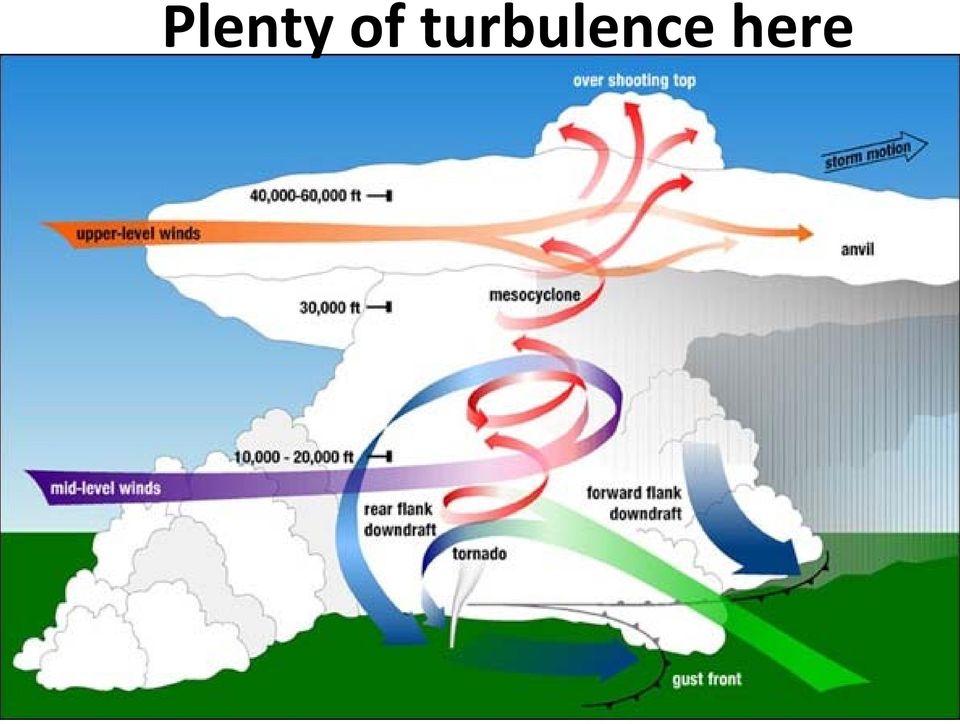
6 Typical types of turbulence Mechanical Mountain waves Convection Air mass boundaries(some fronts, jet stream)

7 Mechanical Turbulence Occurs near the surface Caused by friction, and obstructions to wind flow Obstacles include trees, buildings, and terrain. The stronger the wind or the larger obstruction, the stronger the turbulence

8

9 Add a really large obstacle

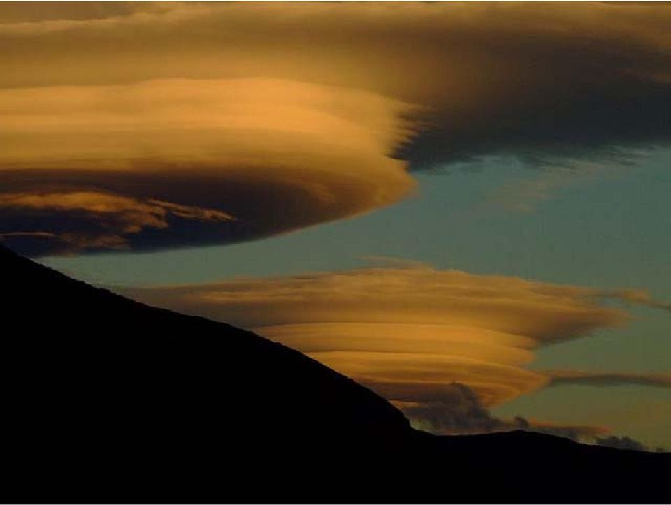
10 Mountain wave turbulence Mountain wave turbulence is amongst the strongest on earth

11

12
13 British Overseas Airways Flight 911, departing Tokyo, March

14 Thermal Turbulence (Free Convection) Formed by rising thermals due to surface heating during the day. These may form convective clouds by afternoon. So if you want the smoothest ride, take the morning flight!

15 Plenty of turbulence here
16 Air France 447, June In the early morning hours of June , Air France maintenance computers began recording a series of automated text messages from one of their aircraft on a nightly flight across the Atlantic between Rio de Janeiro and Paris. Lasting 4 minutes, the text messages indicated a host of system failures... After these messages ceased, no further contact with the aircraft was ever made.

17 This is the most direct route between Rio and Paris. The actual route of flight would be very close to this.

18

19

20 Autopilot disengage Autothrust disengage Flight control computers multiple failures resorting to alternate profile Rudder limiter fault TCAS fault Flight envelope warning Guidance 1 fault Guidance 2 fault Guidance 3 fault Standby instruments 1 fault Standby instruments 2 fault air data computer fail Remaining air data computers disagree Flight management computers fault Primary flight display fault Secondary flight display fault Cabin Depressurizing >End of messages< While the official investigation is ongoing, it is fairly clear that the scope of system failures indicates that following some initial shock, the aircraft is unable to be flown. Pieces of flight controls, possibly large sections of the plane, have likely detached. The final message probably indicates the fuselage is breaking up, or perhaps it is the last gasp of the failing computer

21
22 Delta 191, DFW, August
23 Typical microburst Airport
24
25 Wind shear creating turbulent eddies Sample jet stream 150mb 75 knots 250mb 130 knots 350mb 100 knots 450mb 80 knots Man its too bumpy up here to take a nap, call up Denver center and see if the ride gets smoother ahead Ya, but check out this tailwind
26 Turbulence Detection
27 Local Winds: Sea-Land Breeze Mountain-Valley Circulation Basically the same physical idea for each one: 1. A direct thermal circulation which occurs a small enough scale that the pressure gradient is the dominant force which drives the wind. 2. Driven by the diurnal cycle of solar heating.
28 Sea-Land Breeze DAYTIME NIGHTIME PGF PGF Water is relatively cool Land is relatively warm Onshore flow at the surface Offshore flow aloft. Water is relatively warm Land is relatively cool Offshore flow at the surface Onshore flow aloft. Occurs because water has a high heat capacity, so it heats and cools more slowly than the land.
29 Sea Breeze Circulation and Sea Breeze Front Sea breeze forces air to converge over land, leading to upward motion and formation of clouds and storms.
30 Sea Breeze Front: North Carolina Example EARLY MORNING MID AFTERNOON MID MORNING LATE AFTERNOON (University of Wisconsin)
31 Florida Peninsula Sea breeze is blowing the smoke from a forest file away from the Gulf of Mexico side (FL Dept. of Forestry).
32 Mountain-Valley Winds DAYTIME NIGHTTIME Air is heated along mountain slopes Warmed air is locally less dense than the surrounding air above the valley. Upslope flow. Air is cooled along mountain slopes Cooled air is locally more dense than the surrounding air above the valley. Downslope flow.
33 Local Topography of Tucson, AZ CATALINA MTNS. TUCSON MTNS. TUCSON MTNS. We re surrounded by mountains on three sides, so mountain valley circulations play a BIG role in our weather especially during the monsoon! X University of AZ RINCON MTNS.
How Do Oceans Affect Weather and Climate?
 How Do Oceans Affect Weather and Climate? In Learning Set 2, you explored how water heats up more slowly than land and also cools off more slowly than land. Weather is caused by events in the atmosphere.
WEATHER THEORY Temperature, Pressure And Moisture
 WEATHER THEORY Temperature, Pressure And Moisture Air Masses And Fronts Weather Theory- Page 77 Every physical process of weather is a result of a heat exchange. The standard sea level temperature is 59
This chapter discusses: 1. Definitions and causes of stable and unstable atmospheric air. 2. Processes that cause instability and cloud development
 Stability & Cloud Development This chapter discusses: 1. Definitions and causes of stable and unstable atmospheric air 2. Processes that cause instability and cloud development Stability & Movement A rock,
Chapter 7 Stability and Cloud Development. Atmospheric Stability
 Chapter 7 Stability and Cloud Development Atmospheric Stability 1 Cloud Development - stable environment Stable air (parcel) - vertical motion is inhibited if clouds form, they will be shallow, layered
8.5 Comparing Canadian Climates (Lab)
") These 3 climate graphs and tables of data show average temperatures and precipitation for each month in Victoria, Winnipeg and Whitehorse: Figure 1.1 Month J F M A M J J A S O N D Year Precipitation 139
These 3 climate graphs and tables of data show average temperatures and precipitation for each month in Victoria, Winnipeg and Whitehorse: Figure 1.1 Month J F M A M J J A S O N D Year Precipitation 139
UNIT VII--ATMOSPHERIC STABILITY AND INSTABILITY
 UNIT VII--ATMOSPHERIC STABILITY AND INSTABILITY The stability or instability of the atmosphere is a concern to firefighters. This unit discusses how changes in the atmosphere affect fire behavior, and
Basics of weather interpretation
 Basics of weather interpretation Safety at Sea Seminar, April 2 nd 2016 Dr. Gina Henderson Oceanography Dept., USNA ghenders@usna.edu Image source: http://earthobservatory.nasa.gov/naturalhazards/view.php?id=80399,
Quadrant 1 Sea Breeze: Routing Considerations Table of Contents
 Quadrant 1 Sea Breeze: Routing Considerations Table of Contents Introduction Quadrant 1 Sea Breeze Description 2 3 Introduction Four Sea Breeze Quadrants (Figure 1) When considering a sea breeze and its
Southern AER Atmospheric Education Resource
 Southern AER Atmospheric Education Resource Vol. 9 No. 5 Spring 2003 Editor: Lauren Bell In this issue: g Climate Creations exploring mother nature s remote control for weather and Climate. g Crazy Climate
Lecture 4: Pressure and Wind
 Lecture 4: Pressure and Wind Pressure, Measurement, Distribution Forces Affect Wind Geostrophic Balance Winds in Upper Atmosphere Near-Surface Winds Hydrostatic Balance (why the sky isn t falling!) Thermal
Hurricanes. Characteristics of a Hurricane
 Hurricanes Readings: A&B Ch. 12 Topics 1. Characteristics 2. Location 3. Structure 4. Development a. Tropical Disturbance b. Tropical Depression c. Tropical Storm d. Hurricane e. Influences f. Path g.
MiSP WEATHER WIND SPEED AND DIRECTION Teacher Guide, L1 L3. Introduction
 MiSP WEATHER WIND SPEED AND DIRECTION Teacher Guide, L1 L3 Introduction This MiSP unit can be included in a standard weather and climate unit. Some teachers may like it as part of the introduction. Others
Chapter 3: Weather Map. Weather Maps. The Station Model. Weather Map on 7/7/2005 4/29/2011
 Chapter 3: Weather Map Weather Maps Many variables are needed to described weather conditions. Local weathers are affected by weather pattern. We need to see all the numbers describing weathers at many
Storms Short Study Guide
 Name: Class: Date: Storms Short Study Guide Multiple Choice Identify the letter of the choice that best completes the statement or answers the question. 1. A(n) thunderstorm forms because of unequal heating
ATMS 310 Jet Streams
 ATMS 310 Jet Streams Jet Streams A jet stream is an intense (30+ m/s in upper troposphere, 15+ m/s lower troposphere), narrow (width at least ½ order magnitude less than the length) horizontal current
7613-1 - Page 1. Weather Unit Exam Pre-Test Questions
 Weather Unit Exam Pre-Test Questions 7613-1 - Page 1 Name: 1) Equal quantities of water are placed in four uncovered containers with different shapes and left on a table at room temperature. From which
5 th Grade Science Vocabulary Words
 5 th Grade Science Vocabulary Words abiotic factor A nonliving part of an ecosystem. acceleration Change in velocity with respect to time. action The force one object applies to a second, as in Newton
Turbulence: The Invisible Hazard presented by Scott Miller PIA Symposium 2005 Jacksonville, Florida, USA
 1300 E. International Speedway Blvd DeLand, FL 32724 USA Tel: +1.386.738.2224 Fax: +1.734.8297 www.performancedesigns.com Turbulence: The Invisible Hazard presented by Scott Miller PIA Symposium 2005 Jacksonville,
Lab Activity on Global Wind Patterns
 Lab Activity on Global Wind Patterns 2002 Ann Bykerk-Kauffman, Dept. of Geological and Environmental Sciences, California State University, Chico * Objectives When you have completed this lab you should
Takeoff Tools TM Crosswind Calculator Instructions Copyright 2005 by Eric C. King. All rights reserved. Rev. 11Sep05. How to Use
 Takeoff Tools TM Crosswind Calculator Instructions Copyright 2005 by Eric C. King. All rights reserved. Rev. 11Sep05 Takeoff Tools TM Suppose you re arriving at, or about to depart from, an airport. You
WeatherBug Vocabulary Bingo
 Type of Activity: Game: Interactive activity that is competitive, and allows students to learn at the same time. Activity Overview: WeatherBug Bingo is a fun and engaging game for you to play with students!
6.4 THE SIERRA ROTORS PROJECT, OBSERVATIONS OF MOUNTAIN WAVES. William O. J. Brown 1 *, Stephen A. Cohn 1, Vanda Grubiši 2, and Brian Billings 2
 6.4 THE SIERRA ROTORS PROJECT, OBSERVATIONS OF MOUNTAIN WAVES William O. J. Brown 1 *, Stephen A. Cohn 1, Vanda Grubiši 2, and Brian Billings 2 1 National Center for Atmospheric Research, Boulder, Colorado.
How to analyze synoptic-scale weather patterns Table of Contents
 How to analyze synoptic-scale weather patterns Table of Contents Before You Begin... 2 1. Identify H and L pressure systems... 3 2. Locate fronts and determine frontal activity... 5 3. Determine surface
6 th Grade Science Assessment: Weather & Water Select the best answer on the answer sheet. Please do not make any marks on this test.
 Select the be answer on the answer sheet. Please do not make any marks on this te. 1. Weather is be defined as the A. changes that occur in cloud formations from day to day. B. amount of rain or snow that
Chapter 3: Weather Map. Station Model and Weather Maps Pressure as a Vertical Coordinate Constant Pressure Maps Cross Sections
 Chapter 3: Weather Map Station Model and Weather Maps Pressure as a Vertical Coordinate Constant Pressure Maps Cross Sections Weather Maps Many variables are needed to described dweather conditions. Local
CHAPTER 2 Energy and Earth
 CHAPTER 2 Energy and Earth This chapter is concerned with the nature of energy and how it interacts with Earth. At this stage we are looking at energy in an abstract form though relate it to how it affect
Texas Department of Public Safety Texas Division of Emergency Management. Texas State Operations Center
 Texas Department of Public Safety Texas Division of Emergency Management Texas State Operations Center Situation Awareness Brief Saturday, July 20 th 2013 As of 0900 CDT Tropical Weather Outlook For the
Exploring Florida: Teaching Resources for Science 1 of 6
 Exploring Florida: Teaching Resources for Science 1 of 6 Tropical Cyclones This document describes tropical cyclones and the dangers they pose to coastal populations. It is intended to help teachers improve
Chapter Overview. Seasons. Earth s Seasons. Distribution of Solar Energy. Solar Energy on Earth. CHAPTER 6 Air-Sea Interaction
 Chapter Overview CHAPTER 6 Air-Sea Interaction The atmosphere and the ocean are one independent system. Earth has seasons because of the tilt on its axis. There are three major wind belts in each hemisphere.
Satellite Weather And Climate (SWAC) Satellite and cloud interpretation
 Satellite and cloud interpretation") Satellite Weather And Climate (SWAC) Satellite and cloud interpretation Vermont State Climatologist s Office University of Vermont Dr. Lesley-Ann Dupigny-Giroux Vermont State Climatologist ldupigny@uvm.edu
Satellite Weather And Climate (SWAC) Satellite and cloud interpretation Vermont State Climatologist s Office University of Vermont Dr. Lesley-Ann Dupigny-Giroux Vermont State Climatologist ldupigny@uvm.edu
Chapter 2. Aviation Weather Hazards. Icing. Introduction
 LAKP-Ontario and Quebec 9 Chapter 2 Aviation Weather Hazards Introduction Throughout its history, aviation has had an intimate relationship with the weather. Time has brought improvements - better aircraft,
Name: OBJECTIVES Correctly define: WEATHER BASICS: STATION MODELS: MOISTURE: PRESSURE AND WIND: Weather
 Name: OBJECTIVES Correctly define: air mass, air pressure, anemometer, barometer, cyclone, dew point, front, isobar, isotherm, meteorology, precipitation, psychrometer, relative humidity, saturated, transpiration
SIXTH GRADE WEATHER 1 WEEK LESSON PLANS AND ACTIVITIES
 SIXTH GRADE WEATHER 1 WEEK LESSON PLANS AND ACTIVITIES WATER CYCLE OVERVIEW OF SIXTH GRADE WATER WEEK 1. PRE: Evaluating components of the water cycle. LAB: Experimenting with porosity and permeability.
2. The map below shows high-pressure and low-pressure weather systems in the United States.
 1. Which weather instrument has most improved the accuracy of weather forecasts over the past 40 years? 1) thermometer 3) weather satellite 2) sling psychrometer 4) weather balloon 6. Wind velocity is
Robb Kaczmarek NWS FAA Chicago Air Route ATC (Aurora)
") Mike Bardou NWS WFO Chicago (Romeoville) Robb Kaczmarek NWS FAA Chicago Air Route ATC (Aurora) Chicago Aviation Support National Weather Service 1 Chicago Aviation Support National Weather Service 2 Center
Mike Bardou NWS WFO Chicago (Romeoville) Robb Kaczmarek NWS FAA Chicago Air Route ATC (Aurora) Chicago Aviation Support National Weather Service 1 Chicago Aviation Support National Weather Service 2 Center
Clouds for pilots. Ed Williams. http://williams.best.vwh.net/
 Clouds for pilots Ed Williams http://williams.best.vwh.net/ Clouds are important to pilots! Many of our weather problems are associated with clouds: Fog Thunderstorms Cloud In flight icing Cloud physics
Atmospheric Dynamics of Venus and Earth. Institute of Geophysics and Planetary Physics UCLA 2 Lawrence Livermore National Laboratory
 Atmospheric Dynamics of Venus and Earth G. Schubert 1 and C. Covey 2 1 Department of Earth and Space Sciences Institute of Geophysics and Planetary Physics UCLA 2 Lawrence Livermore National Laboratory
Climates are described by the same conditions used to describe
 58 The Causes of Climate R E A D I N G Climates are described by the same conditions used to describe weather, such as temperature, precipitation, and wind. You now know that oceans have an important effect
Partnerships Implementing Engineering Education Worcester Polytechnic Institute Worcester Public Schools
 Partnerships Implementing Engineering Education Worcester Polytechnic Institute Worcester Public Schools Supported by: National Science Foundation Weather: 4.H.3 Weather and Classical Instruments Grade
Seasonal & Daily Temperatures. Seasons & Sun's Distance. Solstice & Equinox. Seasons & Solar Intensity
 Seasonal & Daily Temperatures Seasons & Sun's Distance The role of Earth's tilt, revolution, & rotation in causing spatial, seasonal, & daily temperature variations Please read Chapter 3 in Ahrens Figure
Project Title: Quantifying Uncertainties of High-Resolution WRF Modeling on Downslope Wind Forecasts in the Las Vegas Valley
 University: Florida Institute of Technology Name of University Researcher Preparing Report: Sen Chiao NWS Office: Las Vegas Name of NWS Researcher Preparing Report: Stanley Czyzyk Type of Project (Partners
Convective Clouds. Convective clouds 1
 Convective clouds 1 Convective Clouds Introduction Convective clouds are formed in vertical motions that result from the instability of the atmosphere. This instability can be caused by: a. heating at
Read and study the following information. After reading complete the review questions. Clouds
 Name: Pd: Read and study the following information. After reading complete the review questions. Clouds What are clouds? A cloud is a large collection of very tiny droplets of water or ice crystals. The
We already went through a (small, benign) climate change in The Netherlands
 climate change in The Netherlands") We already went through a (small, benign) climate change in The Netherlands 15-16 October 1987, gusts till 220 km/h, great damage 2004, almost 1400 tornado s December (!!) 2001, Faxai, 879 mbar 27 December
We already went through a (small, benign) climate change in The Netherlands 15-16 October 1987, gusts till 220 km/h, great damage 2004, almost 1400 tornado s December (!!) 2001, Faxai, 879 mbar 27 December
IBM Big Green Innovations Environmental R&D and Services
 IBM Big Green Innovations Environmental R&D and Services Smart Weather Modelling Local Area Precision Forecasting for Weather-Sensitive Business Operations (e.g. Smart Grids) Lloyd A. Treinish Project
defined largely by regional variations in climate
 1 Physical Environment: Climate and Biomes EVPP 110 Lecture Instructor: Dr. Largen Fall 2003 2 Climate and Biomes Ecosystem concept physical and biological components of environment are considered as single,
CGC1D1: Interactions in the Physical Environment Factors that Affect Climate
 Name: Date: Day/Period: CGC1D1: Interactions in the Physical Environment Factors that Affect Climate Chapter 12 in the Making Connections textbook deals with Climate Connections. Use pages 127-144 to fill
WEATHERING, EROSION, AND DEPOSITION PRACTICE TEST. Which graph best shows the relative stream velocities across the stream from A to B?
 NAME DATE WEATHERING, EROSION, AND DEPOSITION PRACTICE TEST 1. The diagram below shows a meandering stream. Measurements of stream velocity were taken along straight line AB. Which graph best shows the
Wind shear - poses challenges and dangers at the most critical stages of flight
 Wind shear - poses challenges and dangers at the most critical stages of flight Authored and illustrated by Sari Jay June 2009 Introduction Over 40 years ago, in the 1960s, low level wind shear was just
Climate of Illinois Narrative Jim Angel, state climatologist. Introduction. Climatic controls
 Climate of Illinois Narrative Jim Angel, state climatologist Introduction Illinois lies midway between the Continental Divide and the Atlantic Ocean, and the state's southern tip is 500 miles north of
Using a Concept Definition Map
 Lesson Plan Using a Concept Definition Map 1. Set Expectations Print Disaster on the board. Tell students, You are going to come up with as many words as you can that are related to the word disaster,
A SEVERE WEATHER CLIMATOLOGY FOR THE WILMINGTON, NC WFO COUNTY WARNING AREA
 A SEVERE WEATHER CLIMATOLOGY FOR THE WILMINGTON, NC WFO COUNTY WARNING AREA Carl R. Morgan National Weather Service Wilmington, NC 1. INTRODUCTION The National Weather Service (NWS) Warning Forecast Office
Storm tide is the water level rise during a storm due to the combination of storm surge and the astronomical tide.
 INTRODUCTION TO STORM SURGE Introduction to Storm Surge BOLIVAR PENINSULA IN TEXAS AFTER HURRICANE IKE (2008) What is Storm Surge? Inland Extent Storm surge can penetrate well inland from the coastline.
Stability and Cloud Development. Stability in the atmosphere AT350. Why did this cloud form, whereas the sky was clear 4 hours ago?
 Stability and Cloud Development AT350 Why did this cloud form, whereas the sky was clear 4 hours ago? Stability in the atmosphere An Initial Perturbation Stable Unstable Neutral If an air parcel is displaced
Making Aviation Safer: Results of the National Aviation Weather Program s 10-Year Goal to Reduce Weather- Related Accidents by 80 Percent
 1 Making Aviation Safer: Results of the National Aviation Weather Program s 10-Year Goal to Reduce Weather- Related Accidents by 80 Percent Friends/Partners of Aviation Weather October 9, 2008 Jud Stailey,
Storm tide is the water level rise during a storm due to the combination of storm surge and the astronomical tide.
 INTRODUCTION TO STORM SURGE Introduction to Storm Surge National Hurricane Center Storm Surge Unit BOLIVAR PENINSULA IN TEXAS AFTER HURRICANE IKE (2008) What is Storm Surge? Inland Extent Storm surge can
AIRCRAFT PERFORMANCE Pressure Altitude And Density Altitude
 Performance- Page 67 AIRCRAFT PERFORMANCE Pressure Altitude And Density Altitude Pressure altitude is indicated altitude corrected for nonstandard pressure. It is determined by setting 29.92 in the altimeter
Heat Transfer and the Movement of Air
 LESSON 4 Heat Transfer and the Movement of Air INTRODUCTION How can a hang glider stay up in the air for hours without a motor? How can a bird soar over an open field without flapping its wings? They can
6.E.2.2 Plate Tectonics, Earthquakes and Volcanoes
 Name: Date: 1. The road shown below was suddenly broken by a natural event. 3. The convergence of two continental plates would produce Which natural event most likely caused the crack in the road? island
California Standards Grades 9 12 Boardworks 2009 Science Contents Standards Mapping
 California Standards Grades 912 Boardworks 2009 Science Contents Standards Mapping Earth Sciences Earth s Place in the Universe 1. Astronomy and planetary exploration reveal the solar system s structure,
1. Theoretical background
 1. Theoretical background We consider the energy budget at the soil surface (equation 1). Energy flux components absorbed or emitted by the soil surface are: net radiation, latent heat flux, sensible heat
CLIMATE OF RWANDA. Overview. Linked to other lessons
 Geography S6 GENERAL PHYSICAL GEOGRAPHY OF RWANDA Lesson 75 Developed by (Niwagaba Innocent) Subtopic Climate and factors influencing it in Rwanda Specific Objectives The learners must be able to: Describe
Geography affects climate.
 KEY CONCEPT Climate is a long-term weather pattern. BEFORE, you learned The Sun s energy heats Earth s surface unevenly The atmosphere s temperature changes with altitude Oceans affect wind flow NOW, you
Air Masses and Fronts
 Air Masses and Fronts Air Masses The weather of the United States east of the Rocky Mountains is dominated by large masses of air that travel south from the wide expanses of land in Canada, and north from
Georgia Performance Standards Framework for Natural Disasters 6 th Grade
 The following instructional plan is part of a GaDOE collection of Unit Frameworks, Performance Tasks, examples of Student Work, and Teacher Commentary. Many more GaDOE approved instructional plans are
Mid latitude Cyclonic Storm System. 08 _15 ab. jpg
 Mid latitude Cyclonic Storm System 08 _15 ab. jpg Mid Latitude Cyclone Storm System (MLCSS) It has several names. Cyclone, Cyclonic Storm, Cyclonic System, Depression. Cyclonic Storms are the weather maker
Chapter 6: Cloud Development and Forms
 Chapter 6: Cloud Development and Forms (from The Blue Planet ) Why Clouds Form Static Stability Cloud Types Why Clouds Form? Clouds form when air rises and becomes saturated in response to adiabatic cooling.
Meteorology: Weather and Climate
 Meteorology: Weather and Climate Large Scale Weather Systems Lecture 1 Tropical Cyclones: Location and Structure Prof. Roy Thompson Crew building Large-scale Weather Systems Tropical cyclones (1-2) Location,
APPENDIX 3-B Airplane Upset Recovery Briefing. Briefing. Figure 3-B.1
 APPENDIX 3-B Airplane Upset Recovery Briefing Industry Solutions for Large Swept-Wing Turbofan Airplanes Typically Seating More Than 100 Passengers Briefing Figure 3-B.1 Revision 1_August 2004 Airplane
Anticyclones, depressions, hot & drought, cold & snow
 AS/A2-Level Geography Anticyclones, depressions, hot & drought, cold & snow Learning Objectives: To describe and explain the weather associated with high and low pressure systems and their links to extreme
The Ideal Gas Law. Gas Constant. Applications of the Gas law. P = ρ R T. Lecture 2: Atmospheric Thermodynamics
 Lecture 2: Atmospheric Thermodynamics Ideal Gas Law (Equation of State) Hydrostatic Balance Heat and Temperature Conduction, Convection, Radiation Latent Heating Adiabatic Process Lapse Rate and Stability
VOCALS-CUpEx: The Chilean Upwelling Experiment
 VOCALS-CUpEx: The Chilean Upwelling Experiment René D. Garreaud 1, José Rutllant 1,2, Ricardo Muñoz 1, David Rahn 1, Marcel Ramos 2 and Dante Figueroa 3 (1) Department of Geophysics, Universidad de Chile;
Humidity, Condensation, Clouds, and Fog. Water in the Atmosphere
 Humidity, Condensation, Clouds, and Fog or Water in the Atmosphere The Hydrologic Cycle Where the Water Exists on Earth Evaporation From the Oceans and Land The Source of Water Vapor for the Atmosphere
DIURNAL CYCLE OF CLOUD SYSTEM MIGRATION OVER SUMATERA ISLAND
 DIURNAL CYCLE OF CLOUD SYSTEM MIGRATION OVER SUMATERA ISLAND NAMIKO SAKURAI 1, FUMIE MURATA 2, MANABU D. YAMANAKA 1,3, SHUICHI MORI 3, JUN-ICHI HAMADA 3, HIROYUKI HASHIGUCHI 4, YUDI IMAN TAUHID 5, TIEN
UNIT IV--TEMPERATURE-MOISTURE RELATIONSHIP
 UNIT IV--TEMPERATURE-MOISTURE RELATIONSHIP Weather is the most variable and often the most critical determinant of fire behavior. This is the first of several units that will deal with weather and its
Indian Ocean and Monsoon
 Indo-French Workshop on Atmospheric Sciences 3-5 October 2013, New Delhi (Organised by MoES and CEFIPRA) Indian Ocean and Monsoon Satheesh C. Shenoi Indian National Center for Ocean Information Services
Fog and Cloud Development. Bows and Flows of Angel Hair
 Fog and Cloud Development Bows and Flows of Angel Hair 1 Ch. 5: Condensation Achieving Saturation Evaporation Cooling of Air Adiabatic and Diabatic Processes Lapse Rates Condensation Condensation Nuclei
ENVIRONMENTAL STRUCTURE AND FUNCTION: CLIMATE SYSTEM Vol. II - Low-Latitude Climate Zones and Climate Types - E.I. Khlebnikova
 LOW-LATITUDE CLIMATE ZONES AND CLIMATE TYPES E.I. Khlebnikova Main Geophysical Observatory, St. Petersburg, Russia Keywords: equatorial continental climate, ITCZ, subequatorial continental (equatorial
Energy & Conservation of Energy. Energy & Radiation, Part I. Monday AM, Explain: Energy. Thomas Birner, ATS, CSU
 Monday AM, Explain: Energy MONDAY: energy in and energy out on a global scale Energy & Conservation of Energy Energy & Radiation, Part I Energy concepts: What is energy? Conservation of energy: Can energy
Flight Operations Briefing Notes
 Flight Operations Briefing Notes I Introduction Flight crew awareness and alertness are key factors in the successful application of windshear avoidance and escape / recovery techniques. This Flight Operations
SECOND GRADE PLATE TECTONICS 1 WEEK LESSON PLANS AND ACTIVITIES
 SECOND GRADE PLATE TECTONICS 1 WEEK LESSON PLANS AND ACTIVITIES PLATE TECTONIC CYCLE OVERVIEW OF SECOND GRADE VOLCANOES WEEK 1. PRE: Investigating the parts of a volcano. LAB: Comparing the parts of a
The Atmosphere and Winds
 Oceanography 10, T. James Noyes, El Camino College 8A-1 The Atmosphere and Winds We need to learn about the atmosphere, because the ocean and atmosphere are tightly interconnected with one another: you
AVIATION INVESTIGATION REPORT A04A0111 LOSS OF CONTROL - COLLISION WITH TERRAIN
 Transportation Safety Board of Canada Bureau de la sécurité des transports du Canada AVIATION INVESTIGATION REPORT A04A0111 LOSS OF CONTROL - COLLISION WITH TERRAIN CANADIAN HELICOPTERS LIMITED AEROSPATIALE
Name Period 4 th Six Weeks Notes 2015 Weather
 Name Period 4 th Six Weeks Notes 2015 Weather Radiation Convection Currents Winds Jet Streams Energy from the Sun reaches Earth as electromagnetic waves This energy fuels all life on Earth including the
climate science A SHORT GUIDE TO This is a short summary of a detailed discussion of climate change science.
 A SHORT GUIDE TO climate science This is a short summary of a detailed discussion of climate change science. For more information and to view the full report, visit royalsociety.org/policy/climate-change
Unit 4 Lesson 2 Plate Tectonics. Copyright Houghton Mifflin Harcourt Publishing Company
 Puzzling Evidence What evidence suggests that continents move? In the late 1800s, Alfred Wegener proposed his hypothesis of continental drift. According to this hypothesis, the continents once formed a
Earth Science Landforms, Weathering, and Erosion Reading Comprehension. Landforms, Weathering, and Erosion
 Reading Comprehension Name 1 How many people have been to the Rocky Mountains or the Grand Canyon? When people go to visit these natural wonders, they may not realize that it took millions of years for
Earth Sciences -- Grades 9, 10, 11, and 12. California State Science Content Standards. Mobile Climate Science Labs
 Earth Sciences -- Grades 9, 10, 11, and 12 California State Science Content Standards Covered in: Hands-on science labs, demonstrations, & activities. Investigation and Experimentation. Lesson Plans. Presented
Geography Gr 10 to Gr 12
 Gr 10 to Gr 12 From Grade 10 to Grade 12 the subject of is offered in The NSC stream at the DSJ. In this regard the school has to follow the requirements and syllabii of the CAPS document for as set out
Low Level Windshear Alert System (LLWAS) An integral part of the U.S. FAA Wind-shear safety program
 An integral part of the U.S. FAA Wind-shear safety program") Low Level Windshear Alert System (LLWAS) An integral part of the U.S. FAA Wind-shear safety program Low-level windshear is a hazard to aircraft in the airport runway corridors. With Climatronics LLWAS,
Low Level Windshear Alert System (LLWAS) An integral part of the U.S. FAA Wind-shear safety program Low-level windshear is a hazard to aircraft in the airport runway corridors. With Climatronics LLWAS,
Dynamics IV: Geostrophy SIO 210 Fall, 2014
 Dynamics IV: Geostrophy SIO 210 Fall, 2014 Geostrophic balance Thermal wind Dynamic height READING: DPO: Chapter (S)7.6.1 to (S)7.6.3 Stewart chapter 10.3, 10.5, 10.6 (other sections are useful for those
FOURTH GRADE WEATHER
 FOURTH GRADE WEATHER 1 WEEK LESSON PLANS AND ACTIVITIES WATER CYCLE OVERVIEW OF FOURTH GRADE WATER WEEK 1. PRE: Comparing different reservoirs of water. LAB: Experimenting with surface tension and capillary
Motion & The Global Positioning System (GPS)
") Grade Level: K - 8 Subject: Motion Prep Time: < 10 minutes Duration: 30 minutes Objective: To learn how to analyze GPS data in order to track an object and derive its velocity from positions and times.
Grade Level: K - 8 Subject: Motion Prep Time: < 10 minutes Duration: 30 minutes Objective: To learn how to analyze GPS data in order to track an object and derive its velocity from positions and times.
Pressure. Curriculum for Excellence. Weather and Climate Cross-curricular project Section 2. Background Information:
 Curriculum for Excellence Weather and Climate Cross-curricular project Section 2 Pressure Background Information: Air pressure is the force exerted by air particles. The air around us pushes on us and
Goal: Understand the conditions and causes of tropical cyclogenesis and cyclolysis
 Necessary conditions for tropical cyclone formation Leading theories of tropical cyclogenesis Sources of incipient disturbances Extratropical transition Goal: Understand the conditions and causes of tropical
Analyze Weather in Cold Regions and Mountainous Terrain
 Analyze Weather in Cold Regions and Mountainous Terrain Terminal Learning Objective Action: Analyze weather of cold regions and mountainous terrain Condition: Given a training mission that involves a specified
TIDES. 1. Tides are the regular rise and fall of sea level that occurs either once a day (every 24.8 hours) or twice a day (every 12.4 hours).
 or twice a day (every 12.4 hours).") TIDES What causes tides? How are tides predicted? 1. Tides are the regular rise and fall of sea level that occurs either once a day (every 24.8 hours) or twice a day (every 12.4 hours). Tides are waves
TIDES What causes tides? How are tides predicted? 1. Tides are the regular rise and fall of sea level that occurs either once a day (every 24.8 hours) or twice a day (every 12.4 hours). Tides are waves
Satellite Derived Dynamic Ocean Currents in the Arctic. Jens Olaf Pepke Pedersen Polar DTU / DTU Space www.polar.dtu.dk www.space.dtu.
 Satellite Derived Dynamic Ocean Currents in the Arctic Jens Olaf Pepke Pedersen Polar DTU / DTU Space www.polar.dtu.dk www.space.dtu.dk Benefits of exploiting ocean currents Benjamin Franklins map of the
PUSD High Frequency Word List
 PUSD High Frequency Word List For Reading and Spelling Grades K-5 High Frequency or instant words are important because: 1. You can t read a sentence or a paragraph without knowing at least the most common.
Environmental Sensitivity of Tropical Cyclone Outflow
 DISTRIBUTION STATEMENT A. Approved for public release; distribution is unlimited. Environmental Sensitivity of Tropical Cyclone Outflow Principal Investigator: Sharanya J. Majumdar Department of Atmospheric