STABILIZA 4.1 INTRODUCTION 4.2 OBJECTIVES
|
|
|
- Jemimah Lang
- 7 years ago
- Views:
Transcription
1 SECTION 4: RESTORATION TION AND BANK STABILIZA ABILIZATION TREATMENTS TMENTS AND PLANS 4.1 INTRODUCTION This Master Plan defines the range of bank stabilization and revegetation techniques that are most appropriate for San Francisquito Creek. The Master Plan emphasizes minimizing structural approaches or adapting them to include revegetation techniques (non-native species removal, native planting), where possible. The comprehensive stabilization and revegetation plan set forth in the Master Plan builds upon an Existing Conditions Report 1 that details the current state of San Francisquito Creek, and is based upon systematic documentation and analyses of existing conditions. Bank stabilization and revegetation techniques in this Master Plan are described at a conceptual level of detail. A landowner who elects to implement one of the techniques would also need to conduct a sitespecific, detailed study to verify the appropriateness and suitability of a technique to adapt the treatment to conditions specific to the property. The detailed design could be developed by a team of professionals hired by the landowner. The final design team may include a professional civil engineer, geomorphologist, geotechnical engineer, revegetation specialist, and fish/wildlife biologist. The design would then be reviewed and subject to approval by the entity administering the Master Plan. 4.2 OBJECTIVES The primary goal of the Master Plan is to develop stabilization schemes for eroding banks that allow vegetation establishment for habitat development, streamside shading, and fisheries enhancement. Where bank protection currently exists, the plan provides a range of approaches, from complete removal and replacement to partial vegetation cover establishment using planting collars and other plant installation techniques. Where bank erosion is severe and close to existing structures, fewer approaches generally apply and tend to be less habitat-friendly. Given the urbanized nature of the stream corridor, there are many constraints to bank stabilization and enhancement of riparian habitat. The guiding principles of the Master Plan are: To preserve and/or enhance the natural character of the urbanized 1 It is not necessary to have a copy of the Existing Conditions Report to understand and use the Master Plan. However, the Existing Conditions Report does provide additional background data useful for revegetation and bank stabilization design. A copy of the Existing Conditions Report is available for review at the main libraries of the Cities of Menlo Park, Palo Alto, and East Palo Alto, on city web pages ( or and at the Peninsula Conservation Center library. 31

2 San Francisquito Creek by increasing the presence of native vegetation. This will improve overall habitat value and stabilize banks - while protecting or improving creek conditions for state- and federally-listed species. To stabilize banks to protect property without reducing floodwater conveyance of the creek. To enhance the value of the creek as a community amenity through access to public areas, interpretation and educational opportunities, and improved visual connections. To develop a unified approach to implementation of the plan within the project area as a means of creating consistency across jurisdictions, and to streamline the permitting process for participating landowners. 4.3 EXISTING CONDITIONS The natural habitats along the creek in the study area are mostly degraded. Bank instability is driven in large part by the predominant high banks, which range between 15 to 30 vertical feet in the study reach. Steep banks are a natural condition for a deep arroyo cut into an alluvial fan (Palou, P., 1926). The high banks are primarily a matter of concern due to their instability, coupled with the presence of nearby buildings and infrastructure. High banks that we see today are a result of this geomorphic setting, as well as anthropogenic changes in the watershed within the last century. Bank conditions range from stable and well vegetated to nearly vertical and eroding. Most of the existing banks in the project reach are partially to mostly vegetated with native and non-native species, with the exception of those reaches with bank protection. Many sparsely vegetated banks are failing, either partially or completely. Bank protection has generally been the responsibility of the individual landowner, except where large channel modifications were implemented. Agencies and individual property owners have responded with a variety of engineered and non-engineered bank protection schemes, some of which are failing or are incompatible with the upstream and downstream bank protection structures (see Existing Conditions Report data). 4.4 METHODS GEOMORPHIC APPROACH In the development of this Master Plan, a geomorphic approach to river management was adopted. This approach applies a holistic view of the watershed and river system, and interprets channel change in relation to basin-wide processes. This perspective was employed in the Existing 32

3 Conditions report to develop the context for bank instability in the study reach. In a more natural stream environment, the geomorphic approach could be applied through the Master Plan stage to characterize and predict at-risk banks based on existing and likely future geomorphic processes. However, due to the superimposition of human development on the geologic context, bank stability cannot be easily predicted based on current fluvial processes alone. Instead, future bank instability will be a result of the interplay of the patchwork of bank stabilization projects in time and space, fluvial processes, and existing and future land uses. Therefore, the bank stabilization methods suggested in this Master Plan are based primarily upon existing bank conditions and adjacent land uses rather than long-term geomorphic processes. This decision-making process was selected for the following reasons: 1) Bank stabilization structures currently line most of the areas where the most extreme bank instability was observed in the 1950s (CRMP, 1998), including along the outside of meander bends in the study reach. Therefore, many of these areas actually are well protected and overall less prone to erosion. 2) Banks are so steep and high that bank erosion potential is pronounced along the majority of the study reach, rather than simply concentrated in areas where hydraulic forces are maximized. 3) City and County representatives requested specific help in identifying priority sites for bank stabilization and revegetation for existing conditions, given the current pronounced bank erosion problems. 4) Erosion risks in the future will depend strongly on the interrelation of individual projects implemented along the study reach. Because it is unknown which methods of bank stabilization and revegetation projects ultimately will be implemented and in what order, it is impossible to project where risks will increase with time in a meaningful way FIELD WORK The existing geomorphic and vegetation conditions of the banks were documented during field inventories of bank, channel, and vegetation conditions. Using extensive site investigation and detailed field mapping, the following items were recorded by location on the topographic maps: 1) geomorphic conditions of the creek banks and bed, 2) existing bank stabilization projects, eroded areas, and sediment types, and 3) existing vegetation along the banks, including habitat types, dominant native and non-native, invasive species. 33

4 Maps displaying key observations appear in the Existing Conditions Report. The record of existing physical and vegetation conditions laid the groundwork for bank stabilization and revegetation recommendations made in this Master Plan report. 4.5 RESULTS Ten bank stabilization and revegetation treatment alternatives are presented in this Master Plan. The treatments are adapted to the conditions found within the project reach to address the current range of physical and biological constraints. The treatments are at the conceptual level of detail. The treatments are described in order of increasing structural complexity and grading requirements. In general, costs increase as well. To the extent possible, a treatment should consider the establishment of some riparian habitat in the design. A description of the structural and vegetation components of each alternative is provided in Section These treatment alternatives include the following: No Action Vegetation Only Repair Protection Vegetate Structure Remove Structure Regrade and Replant Terrace Riprap Toe Vegetated Riprap Vegetated Wall The Master Plan also identifies: 1) those areas where bank stabilization is a priority (Section 4.5.2), and 2) which of the 10 stabilization techniques are possible at each site given the existing land use and topography (Section 4.5.2). 34

5 4.5.1 TREATMENT ALTERNATIVES NO ACTION ALTERNATIVE (A) Conceptual Description This treatment alternative includes leaving existing vegetation and/or structural bank protection in place with no revegetation. While in general the removal of exotics is recommended along San Francisquito Creek, there may be certain mature, well-established species that are not invasive, provide moderate habitat, and help to stabilize the existing banks. For these reasons, in some locations existing vegetation should be retained even if composed of non-native species. Where Appropriate This alternative is appropriate where: 1) bank erosion is not sufficiently serious and threatening to adjacent property to warrant bank improvements or changes, 2) existing structural bank protection does not readily permit revegetation and 3) replacement of existing structural bank protection would be too costly, and/or 4) certain mature, well-established species are not invasive, provide good habitat, or stabilize banks. The prioritization of bank stabilization projects is based upon the erosion severity rating given for segments of the study reach, as outlined in Appendix E. Specifically, those 200-foot sub-reaches of the study reach that received low erosion severity ratings from 3 to 5 were assigned this no-action alternative as a possibility. How to Implement No action will be taken. Existing vegetation and structural bank protection will be left in place. Non-native species will not be removed if they are deemed not invasive or provide limited wildlife habitat. Advantages No short-term costs. Preserves existing habitat. No disturbance to soil, thus preventing erosion. Special access is not required. Disadvantages Does not actively improve bank stability. Eroded areas may worsen with time. Additional Considerations Obviously, if funding is available, it would be possible to replace any existing structures with types permitting native vegetation growth. In addition, as structures degrade with time or as funding becomes available, existing structures can be replaced, preferably with treatment alternatives that incorporate native vegetation. 35

6 VEGETATION ONLY ALTERNATIVE (B) Conceptual Description This treatment alternative includes removal of non-native species and/or revegetation with native species according to restoration guidelines (Section 5.0). This is a purely vegetative treatment and widely recommended where structural bank protection is unnecessary. Where Appropriate This alternative would be implemented in those reaches where banks are stable and erosion is not a serious problem (such as along the Stanford Golf Course). In many areas, this effort will be at the top of bank to provide shade, rather than along the face of the bank. How to Implement Specific non-native removal and revegetation approaches are described in detail in Vegetation Restoration Guidelines, Section 5.0. The removal of non-native vegetation will need to be designed cautiously so as not to result in a large-scale reduction of channel shading or increase erosion potential. For example, phased removal of non-native vegetation (e.g., staggered over several seasons) and concurrent replanting with native species, as appropriate, would minimize the reduction in shade levels over the creek which is important to maintaining steelhead habitat. Advantages Reduces non-native vegetation populations. Relatively inexpensive provided that the native plantings can be collected within the vicinity of the site and contract grown by a native plants nursery. Straightforward. Most operations can be carried out by hand. The use of live materials ensures a long-lasting effectiveness with generalized habitat benefits. Disadvantages This alternative is only feasible in areas with good access when slopes are safe to work upon. May initially reduce bank stability following nonnative removal; not viable where bank stability is expected to worsen considerably. Common Reasons for Failure Lack of maintenance to control non-native species re-establishment or native plant establishment. Additional Considerations Although much revegetation under this alternative is aimed at the top of the channel bank, some planting should also be placed along the face of 36

7 the slope and close to the wetted channel, if possible, so as to increase the amount of shading and vegetation. However, because extensive revegetation (large tree and shrub plantings) may reduce the transport capacity of the channel by slowing and thereby deepening flow, care should be taken in the planting design to minimize these adverse effects on channel conveyance or allow for additional conveyance by increasing the channel cross-sectional area. 37

8 REPAIR PROTECTION ALTERNATIVE (C) Conceptual Description Existing structural bank protection would be repaired. This approach is strictly structural and recommended only in local problem zones. It does not include non-native species removal or native revegetation as vegetation is not typically present at these sites. If not addressed, these erosion hotspots may significantly reduce the lifetime of the existing structure. Where Appropriate This treatment would be applied in those areas where existing structural bank protection is in good condition overall but small erosion problems have developed along the upstream or downstream end or toe of the existing revetment. How to Implement In these cases, the existing revetment can be fixed by reforming the damaged area and extending the structure an adequate distance back into the bank or bed to prevent repeated, local problems. Because no significant change will occur to the structure s position and form, revegetation and non-native species removal is typically not feasible with this type of treatment. However, in some cases it may be feasible to combine this alternative with the Vegetate Structure alternative. Advantages Extends lifetime of existing structure. Requires only local labor. Disadvantages May require complex implementation techniques. Common Reasons for Failure Structure not securely keyed into banks and bottom or adjacent structures. Incompatible techniques juxtaposed. Additional Considerations Where local erosion hotspots are proposed to be fixed along existing bank protection that otherwise appears stable, the installation of instream structures such as wing deflectors is discouraged. Modifying channel characteristics along such reaches may further compromise the integrity of bank protections that are already prone to erosion. 38

9 VEGETATE STRUCTURE ALTERNATIVE (D) Conceptual Description This treatment alternative includes leaving existing bank protection in place and revegetating using planting collars or cuttings inserted between existing bank protection near the toe of the slope, if possible. This treatment is a cost-effective approach to providing some vegetation cover and creek shading without removing the existing bank protection. Where Appropriate This treatment is appropriate where sacked concrete (or some other articulated structural bank stabilization) currently exists, provided that the structure would remain stable if altered. How to Implement The existing bank protection (riprap, sacked concrete, etc.) is removed at a specific location, a planting collar is inserted and backfilled, and vegetation is planted. Planting collars are described in the section entitled Vegetation Restoration Guidelines (Section 5). They can be designed from a variety of materials including wooden beams and concrete boxes. Specific collars should be tailored to each individual site based on the unique needs and conditions of that site. However, only small trees and shrubs will be planted within the planting collars to minimize disturbing the existing bank protection. Where possible, planting areas up to 6-feet long, 3-feet wide, and 2-feet deep are preferable over smaller planting areas to encourage the development of larger habitat pockets. Soil addition and/or decompaction and scarification of the edges of the planting area should be performed to foster vegetation establishment. Some type of irrigation, as outlined in the Vegetation Restoration Guidelines (Section 5.0), would be initially required. Cuttings may be planted along the upstream and downstream edges of sacked concrete to prevent erosion along the existing structure. Installation may be difficult, and equipment (backhoe, crane) may be needed to remove sections of the existing bank protection. Advantages Provides a means of incorporating vegetation in pre-existing structure. Disadvantages This is considered a very constrained revegetation technique, for a number of reasons. The planting collar site is unlikely to be naturally colonized by desirable native trees after the eventual death of the original planting. Replanting of the collars from time to time would thus be necessary. The alteration of existing structural bank protection could 39
 currently exists, provided that the structure would remain stable if")
10 40

11 compromise the stability of the protection. This treatment is more likely to be successful where there is no filter or geotextile fabric underlying existing structural bank protection that would prevent root penetration into the soil below. Where riprap forms a thick layer, this method is not advisable since planting would be difficult. As a result of these numerous limitations, this treatment is not preferable and may not be possible in most situations. Common Reasons for Failure Vegetation mortality. Additional Considerations As with the Vegetation Only Alternative, placing plantings close to the wetted part of the channel would be preferable if the structural integrity of the existing bank protection or flow conveyance is not compromised in the process. 41

12 REMOVE STRUCTURE ALTERNATIVE (E) Conceptual Description This alternative includes removal (and replacement) of existing structural bank protection. In general, this will be a more expensive option than previous replanting approaches. It would involve the extensive use of some hard labor and heavy equipment (backhoes, cranes, etc.) to remove the structures. Where Appropriate This alternative would be implemented where an alternative form of bank protection is strongly preferred and/or existing structural bank protection is in poor condition or has failed. In all cases, this alternative is recommended along with another treatment to replace the existing structure. How to Implement The existing structural bank protection would be removed manually and/ or by heavy equipment. Advantages Maximizes opportunities for revegetation. Disadvantages Labor-intensive. May require dumpsite for materials that cannot be recycled or reused. Additional Considerations Revegetation and non-native species removal can also be performed concurrently if non-native species removal does not require extensive phasing. If existing material is suitable (high quality riprap, for instance), it can be reused elsewhere on the project for bank or channel work. Other types of material (sackrete, broken concrete, etc.) would be hauled offsite. The type of alternative bank treatment chosen would be based on the constraints posed by each site. 42

13 REGRADE AND REPLANT ALTERNATIVE (F) Conceptual Description This alternative uses regrading and biological techniques to provide bank stabilization. Existing vertical or near-vertical banks would be modified to a moderate (3H:1V or less) angle and replanted with native species. Roots of riparian vegetation, rather than structural measures, would provide bank stability. This regrading will disturb some existing vegetation, but will provide a more stable long-term riparian setting and will improve local hydraulic conveyance. This method is considered a preferred method for enhancing aquatic and terrestrial habitat. Where Appropriate Where sufficient right of way exists, a regraded bank is desirable. Regrading and replanting is most appropriate on higher portions of the banks, less frequently affected by high flows, or along lower banks where the water velocities are sufficiently low (less than 5 to 7 feet per second) during the design flow event. Regrading would be necessary where existing slopes are too steep (>3H:1V) to allow vegetation to become established. How to Implement Banks will be regraded, so that the top of bank is located back from the current top of bank. In no cases, should the toe of the regraded slope extend into the existing channel. Vegetation re-establishment can be accomplished using fabrics, cuttings, seed material, or planting containers as per the Vegetation Restoration Guidelines in Section 5.0. Plastic netting, which can trap birds and other animals, is not to be used. Advantages Provides extensive aesthetically pleasing revegetation and habitat enhancement opportunities. Future root growth will perpetuate slope stability. Disadvantages Disturbance of existing vegetation and soil. Only feasible in areas with good access. Lag time between implementation and stability from established root networks. Common Reasons for Failure Occurrence of large flood before vegetation is well-colonized. Inadequate maintenance of plantings which can lead to plant mortality. Additional Considerations Regrading stream banks to achieve a less steep angle and replanting 43

14 44

15 native riparian vegetation is a preferred stabilization alternative with regards to aquatic and terrestrial habitat as it avoids the use of fixed structures. Less steeply graded banks allow for the establishment of a more natural riparian zone. Stabilizing the banks with the roots of riparian vegetation also allows for naturally undercut banks, which provide important steelhead habitat without compromising the overall integrity of the bank. Thus, this stabilization alternative will have beneficial impacts on aquatic habitats in itself. 45

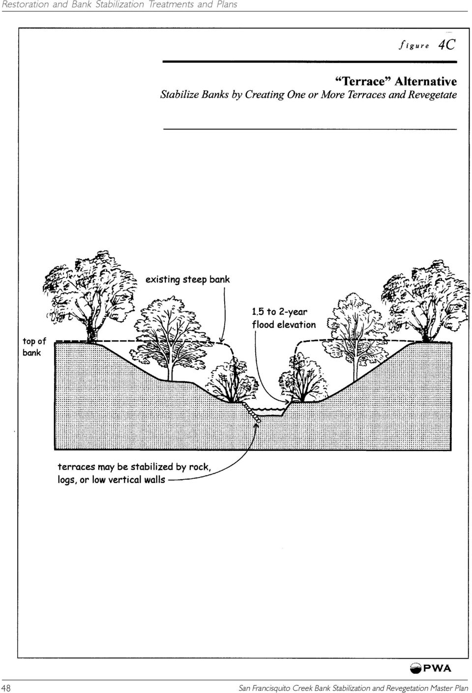
16 TERRACE ALTERNATIVE (G) Conceptual Description This alternative includes stabilizing banks by creating one or more terraces wide benches cut into the streambank. The slope will be excavated and backfilled, as appropriate, to form the terraces. Revegetation techniques will be used to provide habitat and stability to the new bank surface. During floods, water will inundate the terrace(s) and interact with vegetation. This method is considered a preferred method for enhancing aquatic and terrestrial habitat. Where Appropriate Where sufficient right-of-way exists, a terraced bank is desirable. Terraces are often preferred over the creation of a smooth slope to the toe of bank as described in the Regrade and Replant alternative. Terraces are constructed without disturbing the lowest portion of the bank, which is often desirable for habitat reasons. How to Implement One or more terraces are created at increasing elevations above the channel bed, each one supporting a different mix of vegetation species suited to the corresponding inundation frequency, physical setting, and biological conditions. The existing channel is not disturbed below a 1.5- to 2.0-year flow event, thereby maintaining a more confined low flow channel. During floods of greater magnitude, waters flows over the bank onto a wide terrace. The toe of the created terrace must not extend into the existing active channel or impinge upon the 1.5 to 2-year flow. The terrace should be gently sloped (e.g., 2% grade) to drain to the main channel. Riparian vegetation shall be planted on all terraces, including the lowest one, in order to increase shading and the penetration of root masses into the low-flow channel. These features can increase the value of the creek for aquatic and terrestrial wildlife species by providing habitat and mitigating water temperatures. Advantages Long lasting protection. Permits maximum interaction between high flows and riparian vegetation. Mimics channel shape likely in a less incised stream and can facilitate access for maintenance. Disadvantages Labor-intensive. Terrace design constrained by available setback distance. Common Reasons for Failure Mobilization of terrace materials by high flow before vegetation is well 46

17 established. Inadequate sizing of terrace. Additional Considerations If necessary, terrace slopes can be stabilized by large rock, vertical walls (rock, timber, concrete) or logs. If sufficiently long and wide, terraces often provide benefits in terms of flood conveyance and revegetation opportunities. Hydraulic roughness due to revegetation can be offset by the additional conveyance of terraces cut into the pre-existing banks. 47

18 48
19 RIPRAP TOE ALTERNATIVE (H) Conceptual Description This technique combines a biotechnical approach to bank stabilization with toe placement of sufficiently large rocks to prevent bank washout and toe scour. This alternative includes backfilling of the slope and revegetation within and above the riprap. Where Appropriate This technique is recommended where erosion problems are pronounced at the toe of the bank and may compromise overall bank stability if not addressed. It may also be a suitable approach to reducing potential damage due to borrowing of mitten crabs. How to Implement Excavate portions of bank, as necessary. Regrade lower portion of bank to consistent slope. Slopes of 1.5H:1V are acceptable only if rock is placed meticulously to achieve three-point contact between each rock (not dumped); otherwise, more gradual grading is required. The stones should be at the same angle as the slope of the designed streambank, and the total thickness of the stone layer should be at least the thickness of two times the rock diameter, with design diameter depending on the velocity of the design flow event at that location. If desired, the riprap can be extended up the bank to the elevation of the design flow event. The riprap should extend below the predicted scour level and be on a solid foundation. The rock is underlain with filter layer or geotextile fabric, which also extends below the scour level and is secured around the lowest rocks. The entire installation should be keyed into the bank at each end to prevent upstream and downstream scour. Vegetation should be planted on the top of the bank, as well as among the riprap. During rock placement, cuttings are placed between the rock close to the stream channel as per the Vegetation Restoration (Section 5.0) and earth backfill is used to fill voids between the rocks. The riprap would be carefully fitted with planting collars during installation to establish suitable areas for later planting of larger plant materials. The planting collars would provide a barrier between the rock riprap to allow the plants to access native soils below the riprap. Cutting can also be placed between the riprap. Biodegradable erosion control fabric and plantings extend above the rock to the elevation of the 100-year flood level. Advantages Immediate stabilizing effect. Does not involve more rock than necessary for stabilization. 49

20 Disadvantages Could be expensive if rock is not available locally. Labor-intensive; requires use of machinery for rock placement. Common Reasons for Failure Rock too small. Not securely keyed into banks and bottom or adjoining structures. Rocks dumped, not placed. Rocks impinge upon preconstruction channel. Poor maintenance of plantings leading to vegetation mortality. Additional Considerations A number of variations of this alternative are feasible. The rock along the banks can be continued into the channel at some locations to create riffle-pool sequences or form scour pools for resting fish, where conditions on the opposite bank permit. In addition, where the cost of access or slope stability issues make the removal of existing bank protection works impractical or inadvisable, a steep section of large rock could be used to build a wall, which could then be backfilled and planted. Planting collars and/or the selective removal of the underlying bank protection could be used to introduce vegetation. Since bank erosion is generally more extensive, this option was recommended only at one location along the Stanford Golf Course, given existing conditions. Additional locations may become appropriate for this treatment with time. It should be noted that the placement of large rocks at the toe of a bank is considered generally nonbeneficial to aquatic habitats, as it does not generally allow for bank undercutting or other natural variations in bank structure. However, large rock can provide cover and hiding for some fish species. As discussed in Section 6.0, it may be possible to incorporate cover structures to provide some protected pools in underbank areas. 50

21 51
22 52
23 VEGETATED RIPRAP ALTERNATIVE (I) Conceptual Description This alternative involves placing large riprap along the streambank to stabilize the bank surface, backfilling, and revegetating. The technique is effective in immediately securing a bank, and it provides stability while plants become established. Where Appropriate This alternative can also be applied where open space at the top of bank permits regrading of the channel banks to a slope of less than 1.5H:1V and steeper than 3H:1V. (For banks at 3H:1V or less, other, more desirable treatments are appropriate.) In locations where banks are steep (up to 1.5H:1V) and the proximity of existing buildings/roads precludes the wider corridor necessary for regrading at a milder slope or terracing, this alternative represents the preferred methods of structural bank protection. In addition, where flow strongly impinges upon an eroding bank, riprap can be used to minimize erosion hazards by directly armoring the bank. How to Implement Excavate portions of bank, as necessary for construction surface and to maintain flow conveyance. Regrade bank to consistent slope. Slopes of 1.5H:1V are possible only if rock is placed meticulously for three-point contact between rocks. Dumping of rock is not recommended. The stones should be at the same angle as the slope of the designed streambank, and the total thickness of the stone layer should be at least the thickness of two times the design rock diameter, with design diameter depending on the velocity of the design flow event at that location. The uppermost riprap should reach above the elevation of the design flow event. The riprap should extend to the bottom of the bank and be on a solid foundation. The rock is underlain with filter or geotextile fabric, which also extends below the scour level and is secured around the lowest rocks. The entire installation should be inserted into the bank at each end to prevent upstream and downstream scour. Vegetation should be planted on the top of the bank, as well as among the riprap. During rock placement, cuttings are placed between the rock close to the stream channel as per the Vegetation Restoration Guidelines (Section 5.0) and earth backfill is used to fill voids between the rocks. The riprap would be carefully fitted with planting collars during installation to establish suitable areas for later planting of larger plant materials. The planting collars would provide a barrier between the rock 53
24 riprap to allow the plants to access native soils below the riprap. Erosion control fabric and plantings extend above the rock to the elevation of the 100-year flood level. Advantages Immediate stabilizing effect. Disadvantages Poor aesthetics. Could be expensive if rock is not available locally. Labor-intensive; requires use of machinery for rock placement. Common Reasons for Failure Rock too small. Not securely keyed into banks and bottom or adjoining structures. Rocks dumped, not placed. Rocks impinge upon preconstruction channel. Poor maintenance of plantings leads to plant mortality. Additional Considerations Long-term habitat restoration under this scenario would be somewhat difficult due to the limited surface soil available for the plants to root in. The placement of large rocks at the toe of a bank is considered generally nonbeneficial to aquatic habitats, as it does not allow for bank undercutting or other natural variations in bank structure. As discussed in Section 5.0, it may be possible to incorporate cover structures to provide some overhanging features at the toe of the bank. 54
25 VEGETATED WALL ALTERNATIVE (J) Conceptual Description This alternative involves stabilizing near-vertical to vertical banks using planted cribwall, planted gabion baskets, or vertical retaining wall. The slope would be backfilled to the design grade, structural elements constructed, and then soil areas revegetated. A planted cribwall is a rectangular framework of logs or other columnar members and woody cuttings designed to protect an eroding streambank. Gabions are large, rock-filled wire cages that can be used to stabilize steep, badly eroding streambanks. Gabions are constructed from wire, filled with rock and interspersed soil, and embedded into the streambank. Vertical retaining walls are constructed of grouted rock blocks, stacked and anchored timber beams, or concrete. A wall can consist of one feature or several offset, smaller walls. Each of these alternatives would incorporate non-native species removal and revegetation, where possible, to promote local habitat enhancement. Plant selection would have to consider available planting and bank locations and abiotic conditions. Of the three wall approaches described here, the planted cribwall is considered a preferred method for enhancing aquatic and terrestrial habitat. Where Appropriate Steep banks caused by erosion, slumping or undercutting by the current will require additional stabilizing elements before planted vegetation can become firmly established. In locations where banks are exceptionally steep (>1.5H:1V) and the available setback distance is limited, these more intensive structural elements should be applied to protect the banks. High vertical walls should be avoided, except where an important feature (e.g., road or home) is located directly on the edge of the creek bank. Of the three types of walls described here, vegetated cribwalls are generally preferred due to their greater aesthetic value, inclusion of adequate soil for plant growth, and habitat value. A timber or log cribwall may deteriorate more rapidly than walls constructed using metal or concrete materials. However, during this time period, planted riparian vegetation may become established, leaving a bank stabilized primarily by roots. How to Implement: Cribwalls Cribwalls would be constructed using timber or redwood logs, with openings between logs backfilled with soil and planted. Logs should be selected for soundness, durability, uniformity of size, and ease of handling 55
26 and delivery. Timber can be interlocked progressively up the designed elevation along the bank. Concrete cribbing is also available, though less aesthetically pleasing than logs. Cribbing should be embedded below the streambed. The cribwall base is dug parallel to the bank and below the existing streambed. The base log(s) (or other appropriate materials) are placed within this toe trench below stream grade to prevent undercutting of the structure. Base logs should be as long as can be manipulated while conforming to the contour of the stream bank. A good base log is necessary to ensure stability and durability of the treatment. The next series of logs ( tieback logs ) is placed at right angles to the first log. The ends of each log overlap the right angle log below. Each log is secured in place by cutting notches in the wood. Holes can be drilled through the overlapping logs, and steel pins are used to hold them securely. The openings are filled with cuttings and soil. Tieback logs are embedded into the slope 4 to 6 feet, at grade with the base log. There should be at least two tiebacks per base log. Tiebacks can be secured to the base log using threaded rebar. Approximately halfway up the backside of the base log, geotextile fabric is stapled every six inches, and placed to seal the bedding of the structure. Once the first row of logs has had tiebacks and geotextile fabric installed, and has been backfilled to the top of the log, a second face log is placed on top of the tiebacks. This log is set back approximately 6 inches. The same procedure is repeated until desired height is reached. Stacked face-logs used in cribbing must be secured together. A live vegetated cribwall can be built as either single or double walled structures. The double crib wall has far greater resistance to flows. As with most stabilization methods, cribwall works best when used with vegetation. As each lift of the crib wall is installed, long cuttings of riparian plants are inserted on top of each fill layer. The live branches must reach through the crib and into the soil of the bank to ensure rooting. The tips of the branches should protrude from the crib wallface. The tips should stick out from the wall no more than one quarter of the cuttings total length. They must not be packed too closely and bedded in soil for their total length in the crib in order to facilitate rooting over their whole length. The live plants function to replace the crib logs as they decay with time. Riparian plants can grow very rapidly and provide stream shade canopy and wildlife habitat during their first growing season. How to Implement: Gabions Gabion baskets should be filled with a mixture of soil and rock, and then planted with planting collars installed between gabions. Gabion backets that do not incorporate vegetation are discouraged. Implementation of 56
27 57
28 gabion baskets should follow manufacturer specifications. How to Implement: Vertical Retaining Wall While generally undesirable due to habitat considerations, in some locations vertical walls are the necessary or preferred form of bank stabilization. In general, a series of low walls are preferred to a single high wall, as shown in the schematic cross section. Vertical retaining walls can be stepped progressively so that areas between walls could be backfilled and planted. The walls can be constructed of rock, timber beams, or concrete. Concrete walls can (and should where cost permits) be faced with stone or textured to look like rock. This can improve aesthetics and provide more roughness to slow erosive flood flows. Each of these treatments should be installed during the stream s low water periods to prevent disturbance to the stream and simplify construction logistics. Each treatment must include keying the bottom and ends of the structure into the bed and banks. Advantages Provides immediate protection from erosion. Reinforcing action when plants take root results in the formation of a stable rows of mixed vegetation. In some cases of the timber cribwall, ultimately the established vegetation will completely replace the function of the crib wall when after many years, it finally decays. However, where the banks are nearly vertical, the stability provided by root systems may be insufficient to secure the bank alone. Disadvantages Long-term habitat establishment under this alternative may be difficult depending upon the amount of soil available for plant establishment with the treatment chosen. Provision of extensive vegetation cover after completion is almost impossible. Vegetated walls can be expensive if materials (rock, timber) are not available locally. Creating and installing vertical walls can be expensive, complicated, and labor-intensive. Compared with previous alternatives, this approach has a hard or developed appearance, and is more appropriate where a more urbanized look is acceptable. Of the three types of vegetated walls suggested here, the vegetated timber cribwall offers the best aesthetics. Gabion baskets are prone to overall breakage once the structure is locally disturbed. Over time, the wire from gabions may corrode and fall apart. Once broken, the smaller rock inside the wire baskets is subject to washout. In addition, where wire mesh breaks, hazardous conditions 58
29 may exist for fish, other wildlife species, and children. In general, vertical retaining walls do not enhance aquatic or riparian habitat and can create redirected flows and excessive water velocities. Therefore, vertical retaining walls are not preferred. Common Reasons for Failure Not securely keyed into banks and bottom. For timber walls, poor quality wood used. Poor maintenace of installed plantings can lead to plant mortality. Additional Considerations In each case, cover structures may be incorporated to provide some protected areas for use by fish. 59
30 4.5.2 MASTER PLAN MAPS These detailed maps were developed to illustrate the recommended application of the conceptual treatment alternatives. Suggested treatment alternatives are shown superimposed on the existing topography of the project reach and listed by letter. In cases where erosion is not extreme, the No Action alternative is listed generally along with one or more other alternatives. These areas are considered relatively lowpriority bank stabilization sites. The worst erosional hotspots have generally been assigned as the Vegetated Riprap and/or Vegetated Wall alternatives with the No Action alternative not listed as a possibility. These areas are high priority bank stabilization sites. The Master Plan uses existing and potential slope conditions and native and non-native vegetation cover to outline appropriate revegetation alternatives, such as non-native species removal, by location. A detailed description of the step-by-step process by which appropriate treatments were selected is provided in Appendix E. As creek conditions change in the future, it may be necessary to re-evaluate which treatments are appropriate at a given location. It should be noted that in-channel structures can also be used in combination with the bank stabilization methods presented in this Master Plan. In San Francisquito Creek, the main fisheries concern is that of migration (Section 6.0). Wing deflectors are commonly used in-channel structures that act to narrow and deepen flow locally. Stream reaches where bank stability and riparian habitat are sound enough to leave untreated also may be appropriate areas to install wing deflectors in the channel, primarily because it is unlikely that they will cause significant changes to the channel. Wing deflectors would help concentrate low flows into a narrower channel that would facilitate steelhead smolt migration. The structures are discussed in more detail in Section 6.0. As with any structure, wing deflectors would need to be designed and installed with caution so as to avoid creating new erosion problems or exacerbating existing ones. 60
31 4.5.3 GENERAL OBSERVATIONS In the Existing Conditions report, the study reach was divided into four sections of generally similar physical condition. Those reaches are summarized in Table 4A. Table 4A. Subreach categories Subreach Extent of Sub-reach (in feet by station notation) Downstream Extent Description A Station to Upstream face of U.S. Highway 101 B Station to Upstream face of Pope/Chaucer Street Bridge C Station to Downstream of a pedestrian bridge over the Creek. D Station to Downstream of Sand Hill Road. Upstream Extent Description Upstream face of Pope/Chaucer Street Bridge Downstream of a pedestrian bridge over the Creek Downstream of Sand Hill Road Just downstream of USGS gage along Stanford Golf Course The maps showing treatment recommendations (Section 4.5.2) show similar patterns at the sub-reach spatial scale. In Sub-reach A, it is generally recommended that either the No Action alternative or an alternative emphasizing revegetation or non-native species removal ( Vegetation Only or Vegetate Structure ) be applied at present. This is due to the prevalence of sacked concrete along the majority of the streambanks, and the assumption that stabilization of less stable banks will have a higher priority than replacement of existing bank structures. As the sacked concrete deteriorates in the future, other alternatives will also be appropriate. Sufficient funding could permit the complete replacement of sacked concrete with a more habitat-friendly alternative at any time. In Sub-reach B, bank conditions are highly variable. Most banks are not currently protected and are very steep and eroded, with insufficient setback to allow regrading. In the absence of regrading, vegetation is unlikely to re-establish along the entire bank. However, where dense vegetation is present, banks are secured by networks of roots and do not currently require structural stabilization. As a result, the No Action and Vegetated Wall alternatives are recommended at different locations along the banks. The creek is at its greatest sinuosity in this sub-reach, which may also contribute to the highly variable conditions. In Sub-reach C, the following alternatives are the most commonly recommended: No Action, Vegetation Only, and Vegetated Wall. In addition, from STA to , the absence of adjacent development currently permits regrading or terracing of the right bank ( Regrade and Replant and Terrace alternatives). However, future development along the creek in this area could pose additional constraints on bank stabilization alternatives. Alternatively, if the property is de- 61
32 clared open space, it would be appropriate to take No Action and allow erosion natural erosion processes to continue. In Sub-reach D, there are no areas urgently requiring bank stabilization. There are zones where removal of non-native species could be undertaken to improve habitat conditions. 4.6 OPPORTUNITIES Given the existing conditions of the study reach, there are several locations that should first be targeted for bank stabilization and revegetation and offer the greatest opportunity to preclude future erosion hazards REGRADING The right bank of San Francisquito Creek from Station to STA poses the greatest opportunity to enhance physical processes and reduce bank erosion. The left bank (when facing downstream) along this stretch is very steep and eroded. The Master Plan calls for regrading and/or terracing the right bank in this area. This would stabilize the right bank, enhance riparian vegetation, improve the conveyance of the channel in these sections, and diminish shear stresses along the adjacent banks. The feasibility of regrading the bank will depend in part upon the future land use and stewardship of this area, and the potential to remove mature, non-native eucalyptus trees from the top of the bank. As such, there are alternate recommendations for this bank if regrading and/or terracing are not feasible REVEGETATION Because revegetation will frequently occur in tandem with bank stabilization, it is difficult to predict the top priority areas for revegetation. In general, revegetation priority should be given to large, contiguous areas where adequate space at the top-of-bank enables steep, eroding banks to be laid back and a gentler, planting slope created ( Regrade and Replant and Terrace alternatives). Revegetation efforts could then occur on the resulting large, planting surface. Opportunities for this type of revegetation work exist along areas upstream of El Camino Real. Specifically, the area between stations and and between and on the right bank facing downstream offer the best opportunities for this type of large-scale habitat restoration. The portion of San Francisquito Creek traversing the Stanford Golf Course also presents high revegetation opportunities on both banks. These areas are between stations to NON-NATIVE SPECIES REMOVAL The San Francisquito Creek project area has a high component of invasive, non-native species. Generally, non-native species removal efforts should be prioritized starting from upstream locations and moving 62
33 downstream since dispersal of non-native seeds, stems, and roots occurs in that direction. In addition, priorities should be set with the aim of minimizing the total, long-term workload and preserving existing high quality habitat. Non-native management actions are most cost-effective when efforts are focused on detecting and eradicating small colonies of invaders before they alter ecosystem function and degrade native communities. Eradication of islands of noxious, non-native species occurring within areas dominated by native species should be the first priority. 4.7 REFERENCES Palou, P., Memoirs of California, as translated by Bolton, Vol. 3, UC Press, 264 p. CRMP (Flood and Erosion Control Task Force), Reconnaissance Investigation Report of San Francisquito Creek, March. 63
1.7.0 Floodplain Modification Criteria
 1.7.0 Floodplain Modification Criteria 1.7.1 Introduction These guidelines set out standards for evaluating and processing proposed modifications of the 100- year floodplain with the following objectives:
The Teton Creek Restoration Project Summary:
 The Teton Creek Restoration Project Summary: The Teton Creek Restoration Project area extends for approximately one mile upstream from the Cemetery Road Bridge and includes the Aspen Pointe, The Aspens
Chapter 3 CULVERTS. Description. Importance to Maintenance & Water Quality. Culvert Profile
 Chapter 3 CULVERTS Description A culvert is a closed conduit used to convey water from one area to another, usually from one side of a road to the other side. Importance to Maintenance & Water Quality
BRIDGES ARE relatively expensive but often are
 Chapter 10 Bridges Chapter 10 Bridges Bridg Bridges -- usually the best, but most expensive drainage crossing structure. Protect bridges against scour. BRIDGES ARE relatively expensive but often are the
RIPRAP From Massachusetts Erosion and Sediment Control Guidelines for Urban and Suburban Areas http://www.mass.gov/dep/water/laws/policies.
 RIPRAP From Massachusetts Erosion and Sediment Control Guidelines for Urban and Suburban Areas http://www.mass.gov/dep/water/laws/policies.htm#storm Definition: A permanent, erosion-resistant ground cover
Various options are discussed below.these low cost, low impact interventions can also be applied as general erosion control methods.
 Week 10 River Hydraulics Rehabilitating Urban Waterways (From http://hubpages.com/hub/river-bank-erosion-control-methods) See also the resources placed on Moodle. Water channels should be viewed as a resource
GLOSSARY OF TERMS CHAPTER 11 WORD DEFINITION SOURCE. Leopold
 CHAPTER 11 GLOSSARY OF TERMS Active Channel The channel that contains the discharge Leopold where channel maintenance is most effective, sediment are actively transported and deposited, and that are capable
Prattsville Berm Removal Project. 1.0 Project Location
 Prattsville Berm Removal Project 1.0 Project Location The project site is located between the New York State Route 23 Bridge over the Schoharie Creek and the Schoharie Reservoir. The restoration plan encompassed
CITY UTILITIES DESIGN STANDARDS MANUAL
 CITY UTILITIES DESIGN STANDARDS MANUAL Book 2 (SW) SW9 June 2015 SW9.01 Purpose This Chapter provides information for the design of open channels for the conveyance of stormwater in the City of Fort Wayne.
General Permit for Activities Promoting Waterway - Floodplain Connectivity [working title]
![General Permit for Activities Promoting Waterway - Floodplain Connectivity [working title]](/thumbs/39/18645965.jpg "General Permit for Activities Promoting Waterway - Floodplain Connectivity [working title]") General Permit for Activities Promoting Waterway - Floodplain Connectivity [working title] Purpose These rules set forth the conditions under which a person may, without an individual removal-fill permit
General Permit for Activities Promoting Waterway - Floodplain Connectivity [working title] Purpose These rules set forth the conditions under which a person may, without an individual removal-fill permit
Neversink River East Branch
 Neversink River East Branch Management Unit 10 Summary of Post-Flood Recommendations Intervention Level Full restoration of the stream reach including the eroding bank site between Station 38380 and Station
How To Plan A Buffer Zone
 Backyard Buffers Protecting Habitat and Water Quality What is a buffer? A buffer (also called a riparian buffer area or zone) is the strip of natural vegetation along the bank of a stream, lake or other
Outlet stabilization structure
 Overview of Sedimentation and Erosion Control Practices Practice no. 6.41 Outlet stabilization structure Erosion at the outlet of channels, culverts, and other structures is common, and can cause structural
SECTION 5.4 LOGJAM REMOVAL AND RIVER RESTORATION. Overview. Logjam Removal Using Heavy. Tools. Machinery. Large-Scale River Restoration
 SECTION 5.4 LOGJAM REMOVAL AND RIVER RESTORATION Overview Practice 401 Practice 402 Practice 403 Logjam Removal Using Hand-held Tools Logjam Removal Using Heavy Machinery Large-Scale River Restoration
THE OBJECTIVES OF ROUTINE ROAD CUTS AND FILLS
 Chapter 11 Slope Stabiliza bilization and Stability of Cuts and Fills THE OBJECTIVES OF ROUTINE ROAD CUTS AND FILLS are 1) to create space for the road template and driving surface; 2) to balance material
Index. protection. excavated drop inlet protection (Temporary) 6.50.1 6.51.1. Block and gravel inlet Protection (Temporary) 6.52.1
 6.50.1 6.51.1. Block and gravel inlet Protection (Temporary) 6.52.1") 6 Index inlet protection excavated drop inlet protection (Temporary) 6.50.1 HARDWARE CLOTH AND GRAVEL INLET PROTECTION Block and gravel inlet Protection (Temporary) sod drop inlet protection ROCK DOUGHNUT
6 Index inlet protection excavated drop inlet protection (Temporary) 6.50.1 HARDWARE CLOTH AND GRAVEL INLET PROTECTION Block and gravel inlet Protection (Temporary) sod drop inlet protection ROCK DOUGHNUT
Floodplain Connectivity in Restoration Design
 Floodplain Connectivity in Restoration Design 2015 Symposium on Restoration in a Contaminated Environment: Lessons Learned and Challenges in Moving Forward Part II April 2015 Karin Boyd Applied Geomorphology,
Land Disturbance, Erosion Control and Stormwater Management Checklist. Walworth County Land Conservation Department
 Land Disturbance, Erosion Control and Stormwater Management Checklist Walworth County Land Conservation Department The following checklist is designed to assist the applicant in complying with the Walworth
Appendix C. Project Opportunities. Middle Twisp River (RM 7.8 18.12)
") Appendix C Project Opportunities Middle Twisp River (RM 7.8 18.12) This table describes project opportunities by project area. Locator maps of the project opportunities are included below the table. Reach
Appendix C Project Opportunities Middle Twisp River (RM 7.8 18.12) This table describes project opportunities by project area. Locator maps of the project opportunities are included below the table. Reach
Emergency Spillways (Sediment basins)
") Emergency Spillways (Sediment basins) DRAINAGE CONTROL TECHNIQUE Low Gradient Velocity Control Short-Term Steep Gradient Channel Lining Medium-Long Term Outlet Control Soil Treatment Permanent [1] [1]
Emergency Spillways (Sediment basins) DRAINAGE CONTROL TECHNIQUE Low Gradient Velocity Control Short-Term Steep Gradient Channel Lining Medium-Long Term Outlet Control Soil Treatment Permanent [1] [1]
CHAPTER 3A Environmental Guidelines for STREAM CROSSING BY ALL-TERRAIN VEHICLES
 GOVERNMENT OF NEWFOUNDLAND AND LABRADOR DEPARTMENT OF ENVIRONMENT AND LABOUR CHAPTER 3A Environmental Guidelines for STREAM CROSSING BY ALL-TERRAIN VEHICLES WATER RESOURCES MANAGEMENT DIVISION Water Investigations
SANTA BARBARA COUNTY COMPREHENSIVE PLAN LOMPOC AREA
 SANTA BARBARA COUNTY COMPREHENSIVE PLAN LOMPOC AREA A. LAND USE ELEMENT INTERPRETIVE GUIDELINES B. COMMUNITY BENEFITS C. COUNTY ACTION ITEMS Adopted by the Board of Supervisors November 9, 1999 A. Santa
Carlton Fields Memorandum
 Carlton Fields Memorandum TO: FROM: RE: DAN WEEDE FRED RUSHING RIPARIAN BUFFER DATE: JULY 26, 2013 BACKGROUND Both the state of Georgia and the city of Atlanta 1 have certain guidelines that must be followed
Chapter 3 SENSITIVE AREAS AND VEGETATED CORRIDORS
 Chapter 3 3.01 General Provisions 3.01.1 Introduction 3.01.2 Application and Interpretation of Chapter 3.01.3 Unbuildable Lots 3.01.4 Other Permits 3.01.5 Prohibited Activities 3.02 Service Provider Letter
Flood Hazard Area Technical Manual Section 8 Bank Stabilization and Stream Restoration
 Flood Hazard Area Technical Manual Section 8 Bank Stabilization and Stream Restoration Prepared by: New Jersey Section American Water Resources Association Stream Restoration Committee FHA Subcommittee
Safe & Sound Bridge Terminology
 Safe & Sound Bridge Terminology Abutment A retaining wall supporting the ends of a bridge, and, in general, retaining or supporting the approach embankment. Approach The part of the bridge that carries
Interim Technical Guidelines for the Development of Environmental Management Plans for Underground Infrastructure Revised - July 2013.
 Interim Technical Guidelines for the Development of Environmental Management Plans for Underground Infrastructure Revised - July 2013 Rationale Underground infrastructure may be at risk from valley, streambank
River Wensum Restoration Strategy Swanton Morley Restoration Scheme Reach 14a
 River Wensum Restoration Strategy Swanton Morley Restoration Scheme Reach 14a At a glance River restoration benefits: Improved planform, channel cross-section, flow variation and sediment process. Improved
Mission Creek Flood Control & Restoration Project. City of Fremont, Alameda County
 Mission Creek Flood Control & Restoration Project City of Fremont, Alameda County Agenda Background Why are proposed improvements necessary? Proposed project components Challenges Construction schedule/phasing
Appendix C. Municipal Planning and Site Restoration Considerations
 Appendix C Municipal Planning and Site Restoration Considerations 67 68 Appendix C - Municipal Planning and Site Restoration Considerations This appendix contains best practice standards for site planning
DRAFT SOUTH FORK SKYKOMISH RIVER
 DRAFT SOUTH FORK SKYKOMISH RIVER 9 levees and revetments / Approximately 1.1 miles of river bank are armored Revetments provide limited, localized erosion protection, but impact habitat Frequent and costly
Post-Wildfire Clean-Up and Response in Houston Toad Habitat Best Management Practices
 Post-Wildfire Clean-Up and Response in Houston Toad Habitat Best Management Practices Purpose The purpose of this document is to provide guidance and recommendations for minimizing potential impacts to
3. Design Procedures. Design Procedures. Introduction
 Design Procedures 3. Design Procedures Introduction This chapter presents a procedure for the design of natural channels. The chapter primarily focuses on those physical properties of the channel required
DOÑA ANA COUNTY DESIGN STORM CRITERIA GUIDELINES FOR COMMERCIAL AND RESIDENTIAL SITES. Run-off Analysis Methods
 DOÑA ANA COUNTY DESIGN STORM CRITERIA GUIDELINES FOR COMMERCIAL AND RESIDENTIAL SITES Run-off Analysis Methods This document sets forth the minimum design, technical criteria and specifications for the
BMP-7. A sediment filter or an excavated impounding area around a storm drain drop inlet or curb inlet.
 BMP-7 BMP: STORM DRAIN INLET PROTECTION Definition A sediment filter or an excavated impounding area around a storm drain drop inlet or curb inlet. To prevent sediment from entering storm drainage systems
The students will be working in and alongside the stream, so safety is a consideration. Suitable sites should have the following characteristics:
 Measuring Stream Banks: Height and Slope Stream bank heights and slopes are of interest because they yield information relevant to bank erosion and stability. A high, steep bank is likely to be unstable
Monitoring Riparian Areas With a Camera
 Monitoring Riparian Areas With a Camera By Michael DeLasaux 1, Holly George 2, and Philip Mainwaring 3 Riparian areas are next to streams, springs, rivers, ponds and lakes. Physical characteristics that
Table 4.9 Storm Drain Inlet Protetion Applicable for
 BMP C220: Storm Drain Inlet Protection Purpose To prevent coarse sediment from entering drainage systems prior to permanent stabilization of the disturbed area. Conditions of Use Type of Inlet Protection
Ruby River Grayling - Gravel Spawning Beds Monitoring Report January 2008
 Ruby River Grayling - Gravel Spawning Beds Monitoring Report January 2008 In partnership with Montana Department of Fish, Wildlife, and Parks (FWP), American Wildlands, and Wildlife Forever, the Madison
DEPARTMENT OF THE ARMY SECTION 404 REGIONAL GENERAL PERMIT CHANNEL AND BANK PROTECTION STRUCTURES ON THE SOUTH PLATTE RIVER
 DEPARTMENT OF THE ARMY SECTION 404 REGIONAL GENERAL PERMIT CHANNEL AND BANK PROTECTION STRUCTURES ON THE SOUTH PLATTE RIVER Permit Expires: December 31, 2017 Regional General Permit No. 87-01 Issuing Office:
Stream Restoration Post-Implementation Annual Monitoring Report Year 2: 2013 Covering the Period of July 2012 to July 2013
 NCDA&CS - North Carolina Forest Service Stream Restoration Post-Implementation Annual Monitoring Report Year 2: 2013 Covering the Period of July 2012 to July 2013 For the N.C. Division of Water Quality
Storm Drain Inlet Protection - IP
 Storm Drain Inlet Protection - IP DEFINITION A temporary protective device formed around a storm drain drop inlet to trap sediment. PURPOSE To prevent sediment from entering storm drainage systems, prior
The purpose of this meeting is to inform the public of the updates to the project, and to get input before the finalization of the project.
 The purpose of this meeting is inform the public of the updates the project, and get input before the finalization of the project. The following panels describe the purpose and hisry of the project, along
Watershed Works Manual
 National Rural Employment Guarantee Act Watershed Works Manual DRAINAGE LINE TREATMENT: GABION STRUCTURE Baba Amte Centre for People s Empowerment Samaj Pragati Sahayog September 2006 Drainage Line Treatment:
Riprap-lined Swale (RS)
") Riprap-lined Swale (RS) Practice Description A riprap-lined swale is a natural or constructed channel with an erosion-resistant rock lining designed to carry concentrated runoff to a stable outlet. This
Riprap-lined Swale (RS) Practice Description A riprap-lined swale is a natural or constructed channel with an erosion-resistant rock lining designed to carry concentrated runoff to a stable outlet. This
EFFECTS OF ARUNDO DONAX ON RIVER HYDRAULICS, SEDIMENT TRANSPORT, AND GEOMORPHOLOGY, SANTA MARGARITA RIVER, CALIFORNIA
 EFFECTS OF ARUNDO DONAX ON RIVER HYDRAULICS, SEDIMENT TRANSPORT, AND GEOMORPHOLOGY, SANTA MARGARITA RIVER, CALIFORNIA René Leclerc Geomorphologist Robert C. MacArthur, Ph.D., P.E. Principal Headwaters
MULTI-AGENCY COMPENSATORY MITIGATION PLAN CHECKLIST 1
 MULTI-AGENCY COMPENSATORY MITIGATION PLAN CHECKLIST 1 Mitigation Goals and Objectives o Describe functions lost at impact site o Describe functions to be gained at mitigation site o Describe overall watershed
Prepared By: Tom Parker Geum Environmental Consulting, Inc.
 Prepared By: Tom Parker Geum Environmental Consulting, Inc. Topics covered: Definition of riparian and floodplain restoration Floodplain attributes as a basis for developing criteria for restoration designs
Vermont Economic Resiliency Initiative (VERI) Community Forum Barre City & Barre Town
 Community Forum Barre City & Barre Town") Vermont Economic Resiliency Initiative (VERI) Community Forum Barre City & Barre Town MEETING NOTES April 16, 2015 6:00 8:00 PM VERI Project Overview With funding from the US Economic Development Administration
Vermont Economic Resiliency Initiative (VERI) Community Forum Barre City & Barre Town MEETING NOTES April 16, 2015 6:00 8:00 PM VERI Project Overview With funding from the US Economic Development Administration
Rhode Island NRCS received approximately $2.4 million in ARRA funds to implement four floodplain easement projects.
 American Recovery and Reinvestment Act (ARRA) Emergency Watershed Protection Program Floodplain Easements Rhode Island Natural Resources Conservation Service Rhode Island NRCS received approximately $2.4
Elevating Your House. Introduction CHAPTER 5
 CHAPTER 5 Elevating Your House Introduction One of the most common retrofitting methods is elevating a house to a required or desired Flood Protection Elevation (FPE). When a house is properly elevated,
Final Report. Dixie Creek Restoration Project. Funded by Plumas Watershed Forum
 Final Report Dixie Creek Restoration Project Funded by Plumas Watershed Forum Plumas Corporation January 2009 1 Background FR-CRM staff presented this project to the Dixie Valley Landowners Association
STANDARD AND SPECIFICATIONS FOR STORM DRAIN INLET PROTECTION
 STANDARD AND SPECIFICATIONS FOR STORM DRAIN INLET PROTECTION Design Criteria Drainage Area The drainage area for storm drain inlets shall not exceed one acre. The crest elevations of these practices shall
INNOVATIONS IN STREAM RESTORATION AND FLOOD CONTROL DESIGN MEETING FLOOD CAPACITY AND ENVIRONMENTAL GOALS ON SAN LUIS OBISPO CREEK 1
 INNOVATIONS IN STREAM RESTORATION AND FLOOD CONTROL DESIGN MEETING FLOOD CAPACITY AND ENVIRONMENTAL GOALS ON SAN LUIS OBISPO CREEK 1 Wayne Peterson 2 Abstract: Can a natural flowing creek be increased
Crossing creeks Stream crossings on farms
 Crossing creeks Stream crossings on farms Looking after all our water needs Crossing creeks Stream crossings on farms Looking after all our water needs Department of Water 168 St Georges Terrace Perth
EMERGENCY HOME PROTECTION. Homeowner's Guide for Emergency Flood Control. Contents INTRODUCTION
 EMERGENCY HOME PROTECTION Homeowner's Guide for Emergency Flood Control Contents Discussion or Section Page Number Introduction 3 Potential Flooding Periods 4 General Rules and Control Aids 5,6 Sandbags
SE-10 STORM DRAIN INLET PROTECTION. Objectives
 STORM DRAIN INLET PROTECTION SE-10 Objectives Erosion Control - EC Sediment Control - SE Tracking Control - TC Wind Erosion Control - WE Non-Storm Water Management - NS Waste and Materials Management -
Jackson Gulch Outlet Canal Rehabilitation Project
 Jackson Gulch Outlet Canal Rehabilitation Project Preliminary Budgetary Estimate for Rehabilitation February 2004 Prepared for the Mancos Water Conservancy District Jackson Gulch Reservoir 42888 County
Stormwater/Wetland Pond Construction Inspection Checklist
 : Construction Inspection ChecklistsTools Stormwater/Wetland Pond Construction Inspection Checklist Project: Location: Site Status: Date: Time: Inspector: SATISFACTORY/ UNSATISFACTORY COMMENTS Pre-Construction/Materials
March 2008. Prepared by: Irvine Ranch Water District. 15600 Sand Canyon Avenue. Irvine, CA 92618. Contact: Natalie Likens (949) 453-5633
 453-5633") ADDENDUM TO THE MICHELSON WATER RECLAMATION PLANT PHASE 2 & 3 CAPACITY EXPANSION PROJECT FEBRUARY 2006 FINAL ENVIRONMENTAL IMPACT REPORT AND THE SAN JOAQUIN FRESHWATER MARSH ENHANCEMENT PLAN REVISED SEPTEMBER
ADDENDUM TO THE MICHELSON WATER RECLAMATION PLANT PHASE 2 & 3 CAPACITY EXPANSION PROJECT FEBRUARY 2006 FINAL ENVIRONMENTAL IMPACT REPORT AND THE SAN JOAQUIN FRESHWATER MARSH ENHANCEMENT PLAN REVISED SEPTEMBER
Earth Science. River Systems and Landforms GEOGRAPHY 1710. The Hydrologic Cycle. Introduction. Running Water. Chapter 14.
 Earth Science GEOGRAPHY 1710 River Systems and Landforms DAVID R. SALLEE Robert W. Christopherson Charlie Thomsen Chapter 14 Introduction Rivers and streams are dynamic systems that continually adjust
Thank you to all of our 2015 sponsors: Media Partner
 Thank you to all of our 2015 sponsors: Media Partner Channel Naturalization: Planning and Implementation in Peel Region TRIECA March 25 & 26, 2015 Peel Region Channel Remediation Strategy An Urban Context
A Stream Restoration Case Study in the California Central Coast
 International Erosion Control Association Annual Conference 2009, Reno, Nevada Case Study Technical Presentation A Stream Restoration Case Study in the California Central Coast Justin S. Rogers, P.E.,
Storm Drain Inlet Protection
 Categories EC Erosion Control SE Sediment Control TC Tracking Control WE Wind Erosion Control Non-Stormwater NS Management Control Waste Management and WM Materials Pollution Control Legend: Primary Category
 Coldwater Heritage Partnership Implementation Grant Final Report Morrison Run Watershed Restoration Project Western Pennsylvania Conservancy Project Summary The goal of the Morrison Run Watershed Restoration
San Diego Integrated Regional Water Management Implementation Grant Proposal Economic Analysis Flood Damage Reduction Costs and Benefits
 Attachment 9 San Diego Integrated Regional Water Management Economic Analysis Flood Damage Reduction Costs and Benefits Attachment 9 consists of the following items: Flood Damage Reduction Costs and Benefits.
Gold Ray Dam Interagency Technical Team Meeting
 Gold Ray Dam Interagency Technical Team Meeting Agenda Public Outreach, Funding, Monitoring EA/BA/Permit Updates Deconstruction Plans Fish Passage & Salvage Plan Hydraulic Modeling Next Steps Public Outreach,
Welded Mesh Gabions and Mattresses River Protection Design Guide HY-TEN GABION SOLUTIONS Dunstall Hill Trading Estate, Gorsebrook Road,
 Welded Mesh Gabions and Mattresses River Protection Design Guide HY-TEN GABION SOLUTIONS Dunstall Hill Trading Estate, Gorsebrook Road, Wolverhampton, WV6 0PJ Tel 01902 712200 Fax 01902 714096 e-mail sales@hy-tengabions.com
DELAWARE COUNTY STREAM CORRIDOR MANAGEMENT PROGRAM TWO-YEAR ACTION PLAN FOR THE WEST BRANCH DELAWARE RIVER CANNONSVILLE RESERVOIR BASIN
 DELAWARE COUNTY STREAM CORRIDOR MANAGEMENT PROGRAM TWO-YEAR ACTION PLAN FOR THE WEST BRANCH DELAWARE RIVER CANNONSVILLE RESERVOIR BASIN May 2011 - April 2013 1. Introduction 2. Recommendations Table of
Mission Reach Self-Guided Tour Mission Concepción Portal Loop and Mission Reach Phase II Embayment Loop
 Mission Reach Self-Guided Tour Mission Concepción Portal Loop and Mission Reach Phase II Embayment Loop Welcome to the Mission Reach! The Mission Reach Ecosystem Restoration and Recreation Project is transforming
City of Shelbyville Site Inspection Checklist
 City of Shelbyville Site Inspection Checklist General Information Project Name: KYR10 Permit Number: Date: Project Location: Contractor: Conractor Representative: Inspector's Name: Title: Signature : Weather
A Developer s Guide: Watershed-Wise Development
 A Developer s Guide: Watershed-Wise Development Environmental Protection What is a watershed? It does not matter how far away you build from a creek, lake, or the ocean, you are in a watershed. Another
720 Contour Grading. General. References. Resources. Definitions
 720 Contour Grading General Contour grading directs water to a desired point, prevents erosion, provides noise deflection, provides visual fit of the facility into the landscape, and protects desirable
Storm Drain Inlet Protection
 Objectives EC Erosion Control SE Sediment Control TR Tracking Control WE Wind Erosion Control Non-Stormwater NS Management Control Waste Management and WM Materials Pollution Control Legend: Primary Objective
Scheduling Maintenance for Infiltration Basins and Trenches
 Visual Inspection for Infiltration Practices Visual inspection is a rapid assessment procedure for qualitatively evaluating the functionality of a stormwater best management practice (BMP). Visual inspections
5.14 Floodplains and Drainage/Hydrology
 I-70 East Final EIS 5.14 Floodplains and Drainage/Hydrology 5.14 Floodplains and Drainage/Hydrology This section discusses floodplain and drainage/hydrology resources and explains why they are important
Environmental Case Study Decatur, Georgia, DeKalb County A Suburban Creek Resists Channelization
 Introduction A visual examination of Doolittle Creek in a highly developed suburban county in Georgia yielded telltale signs of a creek whose original streambed had been altered. Examination of official
A CASE-STUDY OF CUA_DAT CFRD IN VIETNAM
 A CASE-STUDY OF CUA_DAT CFRD IN VIETNAM Giang Pham Hong, Michel Hotakhanh, Nga Pham Hong, Hoai Nam Nguyen, Abstract:Dams have been taken an important role in time and surface redistribution of water for
SEDIMENT/STORMWATER MANAGEMENT BASIN CONSTRUCTION CHECKLIST
 SEDIMENT/STORMWATER MANAGEMENT BASIN CONSTRUCTION CHECKLIST For permanent structures per Delaware SCS Pond Code 378 and Delaware Sediment and Stormwater Regulations KEY PROJECT INFORMATION Item meets standard
Alternative (Flexible) Mitigation Options Proposed Rule - Revised
 Mitigation Options Proposed Rule - Revised") Alternative (Flexible) Mitigation Options Proposed Rule - Revised NC Association of Environmental Professionals June 9, 2011 Background Purposes Update rules due to required changes from statutes Put all
Alternative (Flexible) Mitigation Options Proposed Rule - Revised NC Association of Environmental Professionals June 9, 2011 Background Purposes Update rules due to required changes from statutes Put all
SITE-SPECIFIC BEST MANAGEMENT PRACTICES (BMP) PLAN REVIEW CHECKLIST
 PLAN REVIEW CHECKLIST") This checklist may be used by applicants for encroachment permits, and contractors in development of Site- Specific BMP Plans for projects. plan reviewers will use this checklist to review the Site-Specific
This checklist may be used by applicants for encroachment permits, and contractors in development of Site- Specific BMP Plans for projects. plan reviewers will use this checklist to review the Site-Specific
Fisheries and Oceans Canada-Saskatchewan District 2011 Post-Flood Shoreline Restoration and Stabilization Protocol
 Fisheries and Oceans Canada Pêches et Océans Canada Fisheries and Oceans Canada-Saskatchewan District 2011 Post-Flood Shoreline Restoration and Stabilization Protocol 1.0 Introduction Valid until March
June 2007 CHAPTER 7 - CULVERTS 7.0 CHAPTER 7 - CULVERTS 7.1 GENERAL
 7.0 7.1 GENERAL For the purpose of this manual, culverts are defined as structures that are completely surrounded by soil and located below the surface of the roadway parallel to the general direction
1. Carry water under the canal 2. Carry water over the canal 3. Carry water into the canal
 Lecture 21 Culvert Design & Analysis Much of the following is based on the USBR publication: Design of Small Canal Structures (1978) I. Cross-Drainage Structures Cross-drainage is required when a canal
Proposed General Plan Update Goals, Policies, and Implementation Actions
 Proposed General Plan Update Goals, Policies, and Implementation Actions The construction and maintenance of infrastructure is necessary to support existing and planned land uses and to achieve Environmental
Stream Rehabilitation Concepts, Guidelines and Examples. Objectives. Pierre Y. Julien. Three Laws of Stream Restoration
 Stream Rehabilitation Concepts, Guidelines and Examples Pierre Y. Julien Wuhan 2005 Objectives Part I - Stream restoration and rehabilitation: 1. Present and discuss important concepts, laws, criteria
Temporary Erosion-Control Measures
 A Guide to Temporary Erosion-Control Measures for Contractors, Designers and Inspectors June 2001 North Dakota Department of Health Division of Water Quality A Guide to Temporary Erosion-Control Measures
Proposal to the Trinity Adaptive Management Working Group (TAMWG)
") Proposal to the Trinity Adaptive Management Working Group (TAMWG) Request that the TAMWG recommend that the Trinity River Restoration Program fund BLM to purchase the Weigel parcel at Gold Bar (river mile
Proposal to the Trinity Adaptive Management Working Group (TAMWG) Request that the TAMWG recommend that the Trinity River Restoration Program fund BLM to purchase the Weigel parcel at Gold Bar (river mile
agrees to replace at no charge any tree that dies and subsequent inspection shows that the wire basket was not properly removed.
 Adopted 12/5/00; revised as of 1/2/07 Marietta Tree Commission Rules and Regulations I. Tree Planting A. Planting Specifications 1. Trees must be: A) of a minimum 1¼ inches caliper; B) single stem, straight,
Malibu Creek Subwatershed Cost Estimation Overall Cost Estimate Assumptions
 Overall Cost Estimate This cost estimate is based on several assumptions: These types of projects are extremely variable in their costs, depending on biological, political, and logistical issues encountered.
OSU Extension FACT SHEET
 OHIO STATE UNIVERSITY EXTENSION! OSU Extension FACT SHEET Ohio State University Extension, 2120 Fyffe Road, Columbus, OH 43210 Shale Oil and Gas Development Fact Sheet Series A Landowner s Guide to Understanding
PRIVATE TREATMENT CONTROL BMP OPERATION AND MAINTENANCE VERIFICATION FORM BIORETENTION FACILITIES, VEGETATED SWALES & HIGHER RATE BIOFILTERS
 BIORETENTION FACILITIES, VEGETATED SWALES & HIGHER RATE BIOFILTERS Check here for Address or phone number change the fiscal year (July 1 June 30), and date(s) maintenance was performed. Under Inspection,
6 RETROFITTING POST & PIER HOUSES
 Retrofitting Post & Pier Houses 71 6 RETROFITTING POST & PIER HOUSES by James E. Russell, P.E. 72 Retrofitting Post & Pier Houses Retrofitting Post & Pier Houses 73 RETROFITTING POST AND PIER HOUSES This
DESIGN GUIDELINES FOR EARTH RETENTION
 DESIGN GUIDELINES FOR EARTH RETENTION Strata Systems, Inc. 380 Dahlonega Rd., Suite 200 Cumming, GA 30040 USA www.geogrid.com TABLE OF CONTENTS MECHANICS OF RETAINING WALLS... 3 THE STRATAWEB SOLUTION...4
Appendix H Dredging and Stream Channel Restoration
 Appendix H Dredging and Stream Channel Restoration Mankind s intrusion into the natural environment in West Virginia began in earnest following the Civil War when extractive industries and settlement all
Flood Recovery Stampede Pathway along Elbow River
 Submission for: Flood Recovery Stampede Pathway along Elbow River Project Overview Calgary, Alberta encompasses approximately 230 kilometres of stream bank along the Bow River, Elbow River, Nose Creek
Community Workshop 5. Overarching Goals for Machado Lake Ecosystem and Wilmington Drain Multi-Use Projects
 City of Los Angeles Department of Public Works Bureau of Engineering Machado Lake Ecosystem Rehabilitation Project & Wilmington Drain Multi-Use Project Community Workshop 5 February 24, 2009 In association
ROSE CREEK WATERSHED HYDROLOGIC, HYDRAULIC, SEDIMENT TRANSPORT, AND GEOMORPHIC ANALYSES TASK 1 EXISTING DATA AND INFORMATION SUMMARY REPORT BACKGROUND
 ROSE CREEK WATERSHED HYDROLOGIC, HYDRAULIC, SEDIMENT TRANSPORT, AND GEOMORPHIC ANALYSES TASK 1 EXISTING DATA AND INFORMATION SUMMARY REPORT BACKGROUND The Rose Creek Watershed (RCW) consists of three planning
As stewards of the land, farmers must protect the quality of our environment and conserve the natural resources that sustain it by implementing
 N A T U R A L R E S O U R C E C O N S E R V A T I O N As stewards of the land, farmers must protect the quality of our environment and conserve the natural resources that sustain it by implementing conservation
SECTION 5. Sediment Control Measures
 SECTION 5 Sediment Control Measures 60. STORM DRAIN INLET PROTECTION When Runoff from earth change activities will discharge to a catch basin or storm drain inlet. A newly constructed catch basin or storm