Dunn Loring/Merrifield
|
|
|
- Harry Powers
- 7 years ago
- Views:
Transcription
1 Section 6 Dunn Loring/Merrifield

2 6 2

3 Dunn Loring/Merrifield The Dunn Loring/Merrifield activity center study area consists of the area between I- 66, Old Gallows Road, Arlington Boulevard, and Prosperity Avenue/State Route 699. Some areas south of Route 50, specifically the Exxon-Mobil headquarters and the Inova Fairfax Hospital complex, were considered as part of the field investigation for this study. Located in Fairfax, Virginia, the Dunn Loring/Merrifield area is an employment activity center characterized by relatively high-density existing and proposed office development in several locations. Bounded by the Exxon-Mobil headquarters and the Fairview Business Park on the south and the Prosperity Business Campus and new residential and office development surrounding the Merrifield/ Dunn Loring Metro Station on the north, the area is being redeveloped from a light industrial/strip development to a more upscale and higher-density environment. The area on Lee Highway west of Gallows Road still contains many light industrial businesses, including a large USPS facility. Truck traffic in the area is moderate to heavy. Figure 6-1 shows existing and proposed land use. According to the 2000 census as analyzed by the Metropolitan Washington Council of Government s (COG) 2002 Regional Activity Centers report, there were 2,200 households in the study area and 36,000 jobs, a significant employment center. COG predicts a 40 percent increase in jobs to 51,000 in 2025, and a more modest increase in households to 3,500. Dunn Loring/Merrifield is expected to be the site of significant job growth in the next twenty years. It has received planning attention from Fairfax County in its comprehensive plan. Objectives of that plan include revitalization of the study area into a more pedestrian-friendly and transit-oriented environment. There is significant effort related to focusing development with a more urban feel and density at the transit station area and serving the new development with transit options in order to mitigate traffic impacts. Additionally, a transportation goal in the County s Policy Plan calls for at least 15 percent of the commuter trips to Suburban Centers and Transit Station Areas, such as Dunn Loring/Merrifield, to be made by modes other than single-occupancy vehicles. Consequently, there is strong attention to demand management in the study area, including a very active transportation committee consisting of area business representatives. Private developers have submitted joint development proposals to WMATA for the Dunn Loring station area. Several office and condominium buildings are under construction across from the station. Summary characteristics of the center: High employment area, not concentrated, with some residential. Connection to Metrorail station could be significantly improved. 6 3

4 Potential future transit oriented development site. Potential for new ridership with improvements to existing service is high. Mode share data for the Dunn Loring/Merrifield study area demonstrates that for work end, driving alone is the predominate mode. Home end, although driving alone is still significant at 62 percent, there is some gain for transit which constitutes 20 percent of the mode share. This may reflect the proximity of medium-density housing to the Metrorail station. Table 6-1 Dunn Loring/Merrifield Mode Share Home End Work End Transit Drive Alone Walk/Bike Transit Drive Alone Walk/Bike Dunn Loring/Merrifield 20% 62% 0% 3% 85% 1% Source: 2000 Census Transportation Planning Package 6 4

5 Figure 6-1 Dunn Loring / Merrifield Land Use Proposed Joint Development of Dunn Loring Metrorail Station New Office Development Prosperity Business Campus Dunn Loring/Merrifield Metrorail Station Office Upscale Residential Light Industrial Medium Density Residential USPS Lakeford Business Park Office Park Exxon/Mobil Fairview Business Park Hospital 6 5

6 Transportation System Characteristics Traffic congestion is moderate on Lee Highway as well as US 50 during off-peak hours. During observed peak hours, traffic was congested, particularly at the intersection with Old Gallows Road. Traffic quequed behind Metrobuses and typically did not clear the intersection in a single cycle. Moderate traffic volumes also exist during peak periods on Gallows Road from the I-66 interchange to US 50. Pedestrian Environment The current land use, light-industrial intermixed with auto-oriented retail, and physical layout of the study area discourage pedestrian activity. In addition, although there are pedestrian connections between the Dunn Loring Metrorail station and nearby residential and office areas (eight-minute walk) along Gallows Road, the pedestrian connection to the new office uses along Prosperity Avenue is incomplete. Waiting for the signal at Gallows Road and Prosperity Avenue is long and encourages crossing without a signal during non-peak hours. Other than along Prosperity Avenue, there are relatively few trees and little grass, and no buffer for pedestrians from the traffic along either Lee Highway or Gallows Road. Lighting is adequate along the major roads within the center for pedestrian visibility and safety, and lighting within the Metrorail station area meets WMATA s design standards. The intersection of Lee Highway and Gallows Road is ranked 18 th among intersections in Fairfax County for pedestrian crashes. There were five at this intersection between 1995 and In addition, multiple curb cuts interrupt sidewalks throughout most of the study area, contributing still further to the inhospitable pedestrian environment. Transit Facilities and Operations The primary streets within the study area contain approximately 19 bus stops as shown on Figure 6-2. Of those, only seven stops have shelters. The two bus stops with the highest passenger volume, at the intersection of Lee Highway at Gallows Road, do not have shelters, and waiting patrons have very little space. Transit services include the WMATA s Orange line rail service at the Dunn Loring/Merrifield Metrorail station, two Metrobus routes with several sub-routings, and two Fairfax Connector routes. The Dunn Loring/Merrifield Metrorail station is at the north end of the study area. From the station, Fairfax Hospital, on the south side of study area, is a 10-minute bus ride on Fairfax Connector route FC401. WMATA operates two bus lines through the study area, with several routings along Lee Highway and Arlington Boulevard. The Fairfax Connector routes operate along Gallows Road and within Prosperity Business Park. Bus lines and routings within the study area are shown in Table 6-2 and Figure

7 6 7

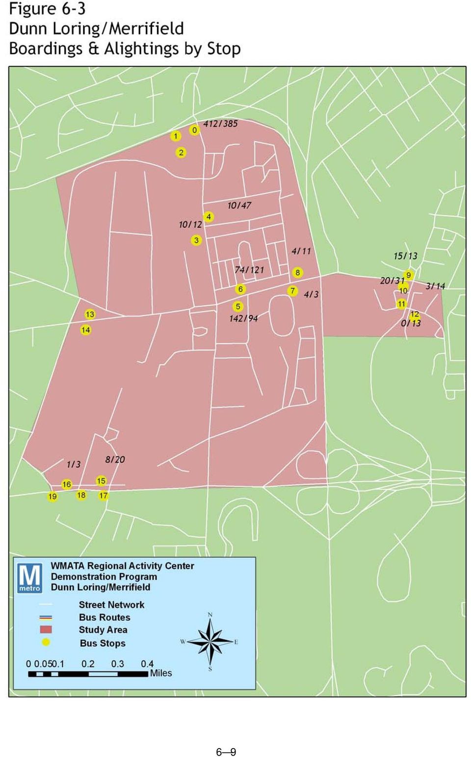
8 WMATA Table 6-2 Existing Bus Service within the Merrifield Study Area Headway Peak Off-Peak Line 1 -Wilson Boulevard-Fairfax Line 1B/D - Ballston Metro/US 50/Fairview Bus. Pk/Dunn Loring Metro C/Z/F - Ballston Metro/US 50/Inova Fairfax Hospital/ Inova Fair Oaks Hospital Line 2 - Washington Blvd. Line 2A/C - Ballston/US 29/Dunn Loring Metro/Tysons Corner B/G - US Fairfax Connector Line Backlick-Gallows Road Line Franconia-Springfield Metro/Fairfax Hospital/ Gallows Road/Dunn Loring Metro/Tysons Corner Line Vienna Metro/Dunn Loring Metro/Prosperity Bus. Park 30 n/a Transit Ridership The heaviest bus passenger volumes in the study area occur at the Dunn Loring/Merrifield Metro Station. The second highest is at the intersection of Lee Highway and Gallows Road with about 220 daily boardings. Other than these locations, transit ridership within the study area is relatively light. The Fairview Business Park has modest ridership with 50 daily boardings. The majority of remaining stops have fewer than 20 daily boardings. Figure 6-3 shows daily weekday ridership at each stop. Ridership information for the Fairfax Connector routes was provided for each line in the center as shown in Table 6-3. This data was provided by Fairfax County Department of Transportation for

9 6 9
10 Table 6-3 Bus Ridership by Route within the Dunn Loring/Merrifield Study Area WMATA Route 1B,C,D,E,F,Z Eastbound 1B,C,D,E,F,Z Westbound 2A,B,C,G Eastbound 2A,B,C,G Westbound Average Percentage Daily Weekday Riders During Ridership AM Peak Riders PM Peak Riders Peak Check Date 1, % February ,147 2, % February , % January , % January 2000 Fairfax Connector 401 2, / Ridership from July 1, 2003-June 30, 2004 Table 6-4 Rail Ridership, Trip Purpose, and Mode of Access for Dunn Loring/Merrifield Ridership AM Peak PM Peak Total Dunn Loring/ 2, ,468 Merrifield Reason for Trip Work Home Dunn Loring/ 17% 71% Merrifield Mode Access Metrobus Fairfax Connector Other Bus Walk Bike Auto Dropped Off Dunn Loring/ Merrifield 4% 6% 3% 16% 1% 51% 14% 6 10

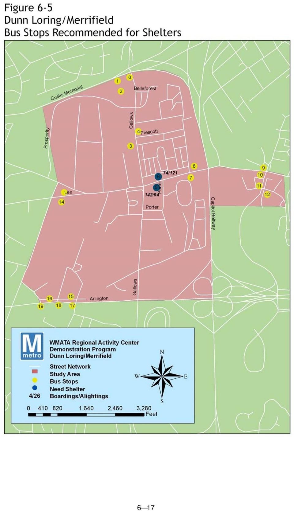
11 Needs and Opportunities The Dunn Loring/Merrfield area possesses a high-quality transit asset, the Dunn Loring/Merrfield Metrorail station, that should serve as an anchor for mobility within the activity center. The center s specific characteristics, and specific needs, as determined in the Regional Bus Study and the field review undertaken for this demonstration program, suggest a few opportunities for improving transit service. The following significant needs and opportunities were identified in the field review and stakeholder interviews: Capital Issues Many of the bus stops with the highest number of boardings have insufficient information, incomplete schedules or no map, or do not have a shelter. Pedestrian connections between the Metrorail station and surrounding development are incomplete and existing pedestrian paths to the station are poorly marked. Transit Operational Issues No serious operational issues were observed, though truck traffic does back up on some left turns, creating congestion that slows bus travel times. 6 11

12 Recommended Actions Dunn Loring/Merrifield is a classic suburban area with land use leaning away from its light industrial past and toward a more transit-oriented, mixed use future. As with most of the centers identified in this demonstration program, in addition to service and capital enhancements, there are some demand management tools that could play a significant part in improving transit ridership. As mentioned earlier in this report, improving service, the lynchpin of transit agency strategies for capturing riders, should contribute to improved ridership at Dunn Loring/Merrifield. In particular, as described below, the circulator path could prove the best opportunity for improving mobility for center users, and improving the accessibility of the Dunn Loring/Merrifield Metrorail Station. Proposed Bus Service and Capital Enhancements Service Metrobus Route 1B, D Test Metrobus routes 1B and 1D at higher frequencies during peak hours in order to establish better accessibility through the Dunn Loring Metrorail station. Currently routes 1B and 1D offer service throughout the week during normal service hours and 1B also offers service on Saturdays. It is recommended to test increasing the frequency of service offered during the weekday peak hours from 30-minute headways to 15- minute headways. No recommendations are suggested for off-peak and weekend service, other than to continue providing such service. Metrobus Route 2C Increase the frequency of service from 30-minute headways to 15-minute headways during weekday peak periods to facilitate better connectivity at the Dunn Loring Metrorail station. Currently the Metrobus 2C service is offered seven days a week during normal service hours. No revisions are suggested for off-peak and weekend service. Metrobus Route 2T Metrobus route 2T currently provides service seven days a week during normal service hours. In order to provide better connectivity at the Dunn Loring Metrorail station, it is proposed to test increased service frequency of the Metrobus 2T route during weekday peak periods. Increase the peak frequency from 30-minute headways to 15- minute headways. Off-peak and weekend service should continue. Fairfax Connector Route 401 This popular route is currently provided weekdays and weekends during normal operating hours. An extended peak service is offered during the week at 30-minute headways and 60-minute headways off-peak. It is recommended to test increasing the peak and off-peak service on weekdays to 15-minute and 30-minute headways respectively to better facilitate the connections at the Dunn Loring Metrorail Station. 6 12

13 Fairfax Connector Route 402/403 Route 402 service is currently offered eastbound during the weekday morning peak and westbound during the weekday evening peak. Route 403 is currently offered westbound during the weekday morning peak and eastbound during the weekday evening peak. The existing service operates on about 30-minute headways. It is proposed to increase the frequency of service to 15-minutes to increase service at the Dunn Loring/Merrifield Metrorail station. Dunn Loring/Merrifield Circulator This circulator, proposed in the Regional Bus Study, would improve transit access to Merrifield employment opportunities, especially for reverse commuters. It would provide a direct connection between Dunn Loring/Merrifield Metrorail station and area employers via Prosperity Avenue and Gallows Road. Service would operate six days a week. During the peak hours the service would be provided at 12-minute headways. All other times service would be provided at 24-minute headways. This report recommends greater coverage than that included in the Regional Bus Study. As shown in Figure 6-4, the extended routing would serve all major business centers as well as several residential areas. If the travel times are excessive to the farthest destinations, the route could be operated bi-directionally or split into two routes, each terminating at the Dunn Loring/Merrifield Metrorail station. 6 13

14 6 14

15 Figure 6-4 Detail of Revised Circulator Route I-66 Dunn Loring/Merrifield Metrorail Station Merrifield Circulator Counter-clockwise in AM Clockwise in PM Serving major business parks and residentiial I-495 Lee Highway Gallows Rd US

16 Regional Bus Study Recommendations Springfield Tysons Center Limited Stop Introduce a new peak-period, limited-stop service, as recommended by the Regional Bus Study. It would provide premium service in the Springfield- Annandale-Tysons Corner corridor. The proposed route would run every 15 minutes during the peak periods only with no weekend service. Capital Current boarding numbers indicate that there are significant numbers of patrons waiting at these stops. During field observations, it was noted that between 5-10 patrons were waiting, usually sitting on the grass swale separating the stop from adjacent parking. There is little space where patrons can wait, and no shelter from weather. Shelters should be provided at: Stop #5 EB Lee Highway at Gallows Road Stop #6 WB Lee Highway at Gallows Road Service and capital improvements are shown on Figure

17 6 17
18 Summary The recommended bus service improvements in the Dunn Loring/Merrifield activity center include higher-frequency service on several existing routes. In addition, a limited-stop service and a circulator are recommended to provide premium service in the heavily traveled corridor and better accessibility to employment opportunities. The enhancements described above would provide an additional 56,000 annual vehicle revenue hours at a cost of about $5.4 million annually, and 24 additional peak buses would be required for a total capital investment of about $8 million. The service improvements operations matrix is shown on the next page. Costs shown are in 2005 dollars. 6 18

19 Dunn Loring/Merrifield Operating Plan Matrix Proposed Service Enhancements Additional Annual Vehicle Revenue Hours (VRH) Additional Daily Peak Vehicles Additional Annual Operating Cost Additional Annual Operating Cost/VRH Annual Ridership Change Additional Capital Cost Buses Service Effectiveness: Ridership/ Revenue hours Metrobus 1B/1D : Only peak hour service calculated Proposed Service 6,000 3 $480,000 $80 227,400 $1,090, Metrobus 2C: Only peak hour service calculated Proposed Service 6,000 3 $480,000 $80 69,700 $1,090, Metrobus 2T: Only peak hour service calculated Proposed Service 6,000 3 $480,000 $80 33,500 $1,090,100 6 Fairfax Connector 401: Peak and Off- Peak service calculated Proposed Service 4,750 1 $380,000 $80 263,700 $363, Fairfax connector 402/403 : Only peak hour service calculated Proposed Service 3,000 2 $240,000 $80 19,100 $726,700 6 Springfield-Tysons Center Limited Stop Regional Bus Study Enhancement 7,500 5 $1,109,100 $ ,800 $1,816, Merrifield-Dunn Loring Circulator Regional Bus Study Enhancement 23,000 7 $1,798,500 $79 243,900 $1,855, Center Total 56, $5,040,000 $90 981,100 $8,032,

20 Supportive policies to promote transit usage As noted, the most significant way to improve transit usage is to upgrade existing service. However, there are several supportive policies that, as a package with service and capital improvements, would promote transit usage in Dunn Loring /Merrifield. These include information and programmatic strategies that might be appropriate for Dunn Loring/ Merrifield. Ensure that existing information at all area bus stops and signage and directions within the Dunn Loring/Merrifield station are up to date and accurate. Improve pedestrian and bike facilities at Dunn Loring/Merrifield station. The most direct pedestrian connection from new development along Prosperity Avenue is directly across from the station parking entrance, where there are no sidewalks. Currently the grass alongside the vehicle entrance is worn, indicating impromptu pedestrian activity through the parking lot and onto Prosperity Avenue. Improve utilization of SmarTrip cards by cross-section of workers in area. The use of SmarTrip for boarding area buses, including Fairfax Connector buses, would improve boarding times. Work with existing local business transportation committee as they develop into a transportation management association and assist with potential shuttle operations. Work with new developers to create transit incentive programs at both employment and residential sites. Coordinate with new development to encourage pedestrian access to bus and rail transit facilities. Partner with Fairfax County to serve transit oriented development with transit service. Advocate that Fairfax County ensure a seamless sidewalk network from new development and redevelopment in the study area to the Metrorail station. Phasing and Timing of Activities The service and capital improvements can be implemented as soon as funding is identified. The new shuttle, in particular, would help improve center transit usage by bringing patrons from the disparate center nodes to the principle transit asset, the Dunn Loring-/Merrifield station. These activities, combined with information at shelters and marketing campaigns to area employers and new residential communities should happen in the near term. Additionally, in the near term, coordination should continue with the existing business organization, including providing technical expertise concerning shuttle operations. 6 20

21 Short-Term Actions Implement service improvements in next round of operations 2006 adjustments Implement shelter improvement with the next round of capital improvements Provide updated route maps and schedules at all area bus 2006 stops Improve pedestrian and bicycle facilities at Dunn Loring 2006 station Develop and execute and outreach campaign with area employers to educate area residents and employees about 2007 transit use, specifically SmarTrip and MetroChek programs Work with area transportation committee as they consider forming a TMA, provide operations expertise Long-Term Actions As development progresses in the center, coordination should take place with area developers, Fairfax County, and the existing local business transportation committee to ensure that new development is served with transit, and that pedestrian connections are maintained and enhanced. In particular, new premium service from between the Dunn Loring/Merrifield activity center and Tysons Corner would, in the long-term, help to adjust the mode split in favour of transit. 6 21
22 Potential Costs and Jurisdictional Responsibilities As stated above, the probable costs associated with the enhancements described would provide an additional 56,000 annual VRH at a cost of about $5.4 million annually, and 24 additional peak buses would be required for a total capital investment of about $8 million. The capital improvements would cost in a range described below: Table 6-5 Potential Costs Improvements unit Unit cost Estimated Dollar Amount WMATA Fairfax County Private Capital Vehicles 24 buses 260,000 $ 6,240,000 x New Shelters 2 shelters 10,000 $ 20,000 x Maps & Signs at bus stops 20 bus stops 500 $ 10,000 x ITS displays 10 displays 25,000 $ 250,000 x Crosswalk painting 6 crosswalks 120 $ 720 x Traffic calming 4 neckdowns 240 $ 960 x total $ 6,521,680 $ 6,500,000 $ 1,680 $ 20,000 Maintenance -- annual Shelters $ 400 x Information $ 2,000 x Crosswalk & traffic calming $ 1,200 total $ 3,600 $ 2,000 $ 1,200 $ 400 TOTAL $ 6,525,280 $ 6,502,000 $ 2,880 $ 400 x Measuring Performance Establish base level ridership for each stop and Dunn Loring/Merrifield station. Do counts after improved information and signage are carried out. Determine base level participation in the MetroChek program. Recount after information campaign and MetroChek outreach to new employers in the area. Measure ridership on new circulator. 6 22
23 Conclusion Like Largo Town Center, the Dunn Loring/Merrifield activity center is poised for substantial change. And like Largo Town Center, Dunn Loring/Merrifield already possesses a high-quality transit facility that should be capitalized upon, its Metrorail station. Implementing a well-routed circulator could do much to capture new riders and improve mobility n the center. Redevelopment of various parcels within the immediate vicinity of the Dunn Loring/Merrifield Metrorail station indicates the level and intensity of development that Fairfax County is eager to pursue in this study area in the future. More dense, more transit-oriented development will be easier for WMATA to match with tailored bus transit service. Another opportunity at Dunn Loring/Merrifield is the growing interest among the business community to implement shuttle service for the burgeoning growth. WMATA should form partnerships to supply operations and other technical expertise with area transportation committees and business organizations. However, the most significant opportunity for enhancing transit service in the corridor and demonstrating WMATA s commitment to customer service consists of supplying shelters at the two highvolume boarding stops. Although shelters were recommended for all of the centers in the demonstration program, these particular shelters would not only serve as a passenger amenity, but should act as an indicator to motorists of pedestrian activity in the area, and hopefully, improve the safety of pedestrians at this intersection. 6 23
FAIRFAX CUE TRANSIT DEVELOPMENT PLAN: FISCAL YEARS 2011 2016
 FAIRFAX CUE TRANSIT DEVELOPMENT PLAN: FISCAL YEARS 2011 2016 Updated October 2010 (Final) Prepared by: Under Sub Contract to: Under Contract to: Table of Contents 1.0 OVERVIEW OF FAIRFAX, VA TRANSIT SERVICES...
30 Years of Smart Growth
 30 Years of Smart Growth Arlington County s Experience with Transit Oriented Development in the Rosslyn-Ballston Metro Corridor A Presentation by the Arlington County Department of Community Planning,
Downtown Tampa Transportation Vision
 Downtown Tampa Transportation Vision Executive Summary August 1, 2006 Hillsborough County Metropolitan Planning Organization County Center, 18 th Floor Tampa, Florida 33602 813-272-5940 www.hillsboroughmpo.org
Florida Avenue Multimodal Transportation Study. June 19, 2013
 Florida Avenue Multimodal Transportation Study June 19, 2013 Today s Agenda Team & project introduction Project Timeline What you said Tools we use Mapped data and what clues it can provide Highlights
Measuring the Street:
 Measuring the Street: New Metrics for 21st Century Streets 1 Measuring the Street: New Metrics for 21st Century Streets New York City s streets are constantly called on to the meet new and varied needs
A Presentation by the Project Managers: Rick Canizales Prince William County. Jana Lynott, AICP Northern Virginia Transportation Commission
 A Presentation by the Project Managers: Rick Canizales Prince William County & Jana Lynott, AICP Northern Virginia Transportation Commission for the: Public Open House and Hearing December 6, 2005 George
Appendix J Santa Monica Travel Demand Forecasting Model Trip Generation Rates
 Appendix J Santa Monica Travel Demand Forecasting Model Trip Generation Rates SANTA MONICA TRAVEL DEMAND FORECASTING MODEL TRIP GENERATION RATES SUBMITTED BY: 201 Santa Monica Blvd., Suite 500 Santa Monica,
6 REGIONAL COMMUTE PATTERNS
 6 REGIONAL COMMUTE PATTERNS INTRODUCTION One of the challenges for this study, which has a primary goal of looking at commute opportunities in MnDOT District 3, is that in some portions of the study area,
TRANSPORTATION SERVICE STANDARDS ELEMENT GOALS, OBJECTIVES & POLICIES
 TRANSPORTATION SERVICE STANDARDS ELEMENT GOALS, OBJECTIVES & POLICIES Background One of the most critical public services provided by a community is the community s transportation system. An effective
Residential Development Travel Plan
 Residential Development Travel Plan A Template for Developers Name of Development (Address) Name of Developer (Contact Details) Date of Travel Plan For office use: Planning reference.. /.. /.. Residential
College of Southern Maryland. Hughesville Transportation Study
 College of Southern Maryland Project Overview Existing Conditions Transit Service Land Use CSM Student Demographics Recommendations Methodology Transit Recommendations Transportation Demand Management
Doing a little can accomplish a lot. Proposed Change of Municipal Class Environmental Assessment from Schedule from B to A+
 Doing a little can accomplish a lot. Proposed Change of Municipal Class Environmental Assessment from Schedule from B to A+ Erin Mills Parkway Intersections at Dundas Street and Burnhamthorpe Road Index
VRE SYSTEM PLAN SUMMARY
 VRE System Plan Summary January 2014 VRE SYSTEM PLAN SUMMARY VRE A Cost-Effective Contributor to Regional Mobility During the last decade, VRE has demonstrated its ability to accommodate a rapid and substantial
Median Bus Lane Design in Vancouver, BC: The #98 B-Line
 Li 1 Median Bus Lane Design in Vancouver, BC: The #98 B-Line Simon Li, P.Eng. PTOE Acting Program Manager, Road and Bridge Projects TransLink (Greater Vancouver Transportation Authority) 1600 4720 Kingsway
Improving Access in Florida International University Biscayne Bay Campus Executive Summary
 EXECUTIVE SUMMARY Improving Access in Florida International University Biscayne Bay Campus Executive Summary Prepared for: Miami-Dade County Metropolitan Planning Organization (Miami-Dade MPO) Prepared
Transit Service Assessment
 Technical Memorandum #1 Transit Service Assessment June 213 Table of Contents 1. Existing Service Summary... 1 1.1 Service Overview... 1 1.2 Service Characteristics... 1 2. Ridership and Productivity...
Managing the Transit Network A Primer on Key Concepts
 Managing the Transit Network A Primer on Key Concepts translink.ca Introduction As the integrated, multi-modal transportation authority for Metro Vancouver, TransLink plans and delivers the transit network
 Walkable Communities Florida Department of Transportation State Safety Office Pedestrian and Bicycle Program April 1995 www.dot.state.fl.us/safety Twelve Steps for an Effective Program Page 1 Twelve Steps
Near Westside Neighborhood and University Avenue Corridor Transportation Study. Public Workshop #2. September 12 and 23, 2013
 Near Westside Neighborhood and University Avenue Corridor Transportation Study Public Workshop #2 September 12 and 23, 2013 Presentation Outline: Brief Review of Study Scope, Background, and Current Conditions
WMATA Regional Benefits of Transit Executive Summary
 WMATA Executive Summary November 2011 Acknowledgements Lead Agency: Prepared By: Washington Metropolitan Area Transit Authority Office of Long Range Planning 600 5 th Street NW Washington, DC 20001 AECOM
NEW BLUE LINE CONNECTIONS
 Washington Metropolitan Area Transit Authority NEW BLUE LINE CONNECTIONS 3/31/2014 A Major Capital Project of Momentum s Metro 2025 Program In support of its new strategic plan, Metro has considered the
Washington Metropolitan Area Transit Authority Board Action/Information Summary
 Washington Metropolitan Area Transit Authority Board Action/Information Summary Action Information MEAD Number: 200212 Resolution: Yes No TITLE: Connecting Communities KPI PRESENTATION SUMMARY: This presentation
for the National Capital Transportation Element
 for the National Capital Transportation Element N A T I O N A L C A P I T A L P L A N N I N G C O M M I S S I O N for the National Capital for the National Capital 77 Federal Elements Transportation contents
GTA Cordon Count Program
 Transportation Trends 2001-2011 Executive Summary Project No. TR12 0722 September 2013 1.0 Introduction The Cordon Count program was established to collect traffic data as a tool for measuring travel trends
GOALS, OBJECTIVES, AND EVALUATION MEASURES
 GOALS, OBJECTIVES, AND EVALUATION MEASURES The Tallahassee-Leon County MPO is developing its first Bicycle and Pedestrian Master Plan, a 20- year plan that provides guidance for the development of facilities
Proposed Service Design Guidelines
 Proposed Service Design Guidelines July 2015 I. Introduction During Phase II of the Reimagining CityBus project, feedback from public outreach and data analysis conducted during Phase I of the project
Master Transportation Plan Demand and System Management Element. Transportation Demand Management (TDM) Transportation System Management (TSM)
 Transportation System Management (TSM)") Master Transportation Plan Demand and System Management Element Transportation Demand Management (TDM) Transportation System Management (TSM) Adopted December 13, 2008 Table of Contents I. Introduction
Master Transportation Plan Demand and System Management Element Transportation Demand Management (TDM) Transportation System Management (TSM) Adopted December 13, 2008 Table of Contents I. Introduction
1. REPORT CONTEXT Description of the development (include all of the following that are known at the time of the application):
:") Transportation Assessment and Management Study Guidelines for Consultants INTRODUCTION This document is intended to provide guidelines for transportation consultants who produce Transportation reports
Transportation Assessment and Management Study Guidelines for Consultants INTRODUCTION This document is intended to provide guidelines for transportation consultants who produce Transportation reports
Light Rail Transit in Phoenix
 4. Presentation and Discussion: Phoenix Light Rail Implementation Wulf Grote Planning and Development Director, Phoenix Valley Metro Light Rail Transit in Phoenix Broadway Citizen s Task Force February
TCRP Report 153: Guidelines for Providing Access to Public Transportation Stations. Part 2: Station Typology and Mode of Access Planning Tool
 TCRP Report 153: Guidelines for Providing Access to Public Transportation Stations Part 2: Station Typology and Mode of Access Planning Tool Jamie Parks, AICP Kittelson & Associates, Inc. Acknowledgements
Executive Summary. Transportation Needs CHAPTER. Existing Conditions
 CHAPTER 1 Executive Summary The City of Forest Grove Transportation System Plan (TSP) was updated to keep it consistent with recent growth trends in the city and other transportation planning efforts in
Needs Analysis. Long Beach Bicycle Master Plan. Bicycle Commuter Needs. LONG BEACH BICYCLE MASTER PLAN Needs Analysis
 Long Beach Bicycle Master Plan Needs Analysis The purpose of reviewing the needs of commuter and recreational bicyclists is twofold: (1) it is instrumental when planning a system which must serve both
INTEGRATION OF PUBLIC TRANSPORT AND NMT PRINCIPLES AND APPLICATION IN AN EAST AFRICAN CONTEXT
 INTEGRATION OF PUBLIC TRANSPORT AND NMT PRINCIPLES AND APPLICATION IN AN EAST AFRICAN CONTEXT MARK BRUSSEL CONTENTS Examples of integration from the Netherlands Rationale and principles of integration
The financial plan was prepared in conjunction with the Technical Working Group. Refer to Table 3-1: Funding and Implementation Plan.
 3 Financial Plan The purpose of the financial plan is to identify funding options that would be likely sources of money to advance recommendations made by this study. The Capitol Region Transportation
Integrated Public Transport Service Planning Guidelines. Sydney Metropolitan Area
 Integrated Public Transport Service Planning Guidelines Sydney Metropolitan Area December 2013 CONTENTS 1. INTRODUCTION 3 1.1 Purpose 3 1.2 Background 3 1.3 Travel in Sydney Metropolitan Area 5 1.4 Objectives
Bus Priority Measures in Calgary: Past, Present and Future. Chris Jordan, M.Sc., P.Eng., Coordinator, Strategic Transit Planning, Calgary Transit
 Bus Priority Measures in Calgary: Past, Present and Future Chris Jordan, M.Sc., P.Eng., Coordinator, Strategic Transit Planning, Calgary Transit Nora Kajdy, P.Eng., Transit Priority Engineer, Calgary Transit
6: LANE POSITIONS, TURNING, & PASSING
 6: LANE POSITIONS, TURNING, & PASSING BASIC LANE POSITIONS Traffic law says that slower vehicles should stay to the right. But where exactly should bicycles ride? Here are some basics. Never Ride Against
Arlington County FY12 Summary Report on Capital Bikeshare
 Arlington County FY12 Summary Report on Capital Bikeshare Arlington County Commuter Services Department of Environmental Services Arlington County, Virginia October 2012 Introduction Capital Bikeshare
New Jersey SRTS Travel Plan Guide
 New Jersey SRTS Travel Plan Guide Prepared For: Funded By: Prepared By: New Jersey Department of Transportation Federal Highway Administration Alan M. Voorhees Transportation Center Edward J. Bloustein
Evergreen Line Rapid Transit Project Business Case Executive Summary. February 2008. Reviewed by
 Evergreen Line Rapid Transit Project Business Case Executive Summary February 2008 Reviewed by Recommendation and Executive Summary The business case for the Evergreen Line Rapid Transit Project (the Project)
Tier 1 Strategies. WV Route 14 Corridor Management Plan
 1.1 1.2 1.3 1.4 Signal timing optimization system improvements. Improve geometry traffic control at high crash intersections. Construct intersection capacity improvement projects. Widen longer sections
University of Guelph Transportation Demand Management (TDM) Plan Changing Our Travel Habits 2009/10 2019/20
 Plan Changing Our Travel Habits 2009/10 2019/20") University of Guelph Transportation Demand Management (TDM) Plan Changing Our Travel Habits 2009/10 2019/20 Introduction: Over the years our society s dependence on the private automobile as the primary
University of Guelph Transportation Demand Management (TDM) Plan Changing Our Travel Habits 2009/10 2019/20 Introduction: Over the years our society s dependence on the private automobile as the primary
STOP CONSOLIDATION TRANSIT STRATEGIES
 TRANSIT STRATEGIES STOP CONSOLIDATION Transit stops are the places where people access transit service, and greatly impact many elements of passengers transit experiences. They are typically thought of
Goals & Objectives. Chapter 9. Transportation
 Goals & Objectives Chapter 9 Transportation Transportation MISSION STATEMENT: TO PROVIDE A TRANSPORTATION NETWORK CAPABLE OF MOVING PEOPLE AND GOODS EFFICIENTLY AND SAFELY. T he transportation system
Mayors Welcome Strong Surrey Votes Yes Coalition Support. Yes Vote Would Vastly Improve Transit and Transportation in Fast Growing City
 Mayors Welcome Strong Surrey Votes Yes Coalition Support Yes Vote Would Vastly Improve Transit and Transportation in Fast Growing City February 11, 2015 Vancouver, BC The Mayors Council on Regional Transportation
Addendum to the Arterial Transitway Corridors Study
 January 2013 1 Addendum to the Arterial Transitway Corridors Study The Arterial Transitway Corridors Study (ATCS) evaluated and prioritized arterial bus rapid transit (BRT) improvements to nine corridors
Lincoln Downtown Master Plan Update
 Lincoln Downtown Master Plan Update Table of Contents Executive Summary........................................... 1 Complete Streets Framework.................................... 3 Promenade Creating
Miami-Dade Transit Service Standards
 Miami-Dade Transit Service Standards Presentation to RTC November 10, 2005 Roosevelt Bradley 1 MDT Service Standards Primer Background Standards: Old & New Best Practices: Comparison Denver RTD ChicagoCTA
MEMORANDUM. Robert Nichols, Acting Corridor Design Manager Northgate Link Extension
 MEMORANDUM DATE: September 23, 2014 TO: Robert Nichols, Acting Corridor Design Manager Northgate Link Extension FROM: SUBJECT: COPIES: Katherine Casseday, PE, PTOE, Casseday Consulting Tony Lo, PE, Parsons
Submission from Living Streets Aotearoa Wellington City Public Transport Spine Study
 Submission from Living Streets Aotearoa Wellington City Public Transport Spine Study Contact person: Ellen Blake Email: wellington@livingstreets.org.nz Phone: 021 1067139 Date: 30 September 2013 About
Evanston Main Street Station TOD Plan and Study. Appendix A.1: Station Area Existing Conditions
 Evanston Main Street Station TOD Plan and Study Appendix A.1: Station Area Existing Conditions EvanstonMainStreetStation TODPlanandStudy A 1 AppendixA.1: ExistingConditions Table of Contents Station Locations
Measuring Success: Transportation Improvements along Sandy Boulevard between NE 13 th and NE 47 th Avenues
 Measuring Success: Transportation Improvements along Sandy Boulevard between NE 13 th and NE 47 th Avenues FINAL REPORT pared by Dan Bower and Scott Cohen City of Portland, Office of Transportation January
Where Do We Want to Go? How Can We Get There?
 Where Do We Want to Go? How Can We Get There? The BRTB has adopted nine goals, with supporting strategies, performance measures, and performance targets. Together, these goals, strategies, measures, and
Advantages and Disadvantages of One Way Streets October 30, 2007
 Advantages and Disadvantages of One Way Streets October 30, 2007 0 P age Background As the revitalization of the Central Waterfront area moves forward, one issue that might need closer analysis is the
Questions and Answers about the Orange Bus/Rail Investment Plan
 Why are transit improvements needed? Questions and Answers about the Orange Bus/Rail Investment Plan The Triangle Region is now home to 1.5 million people. The U.S. Census and the 2035 Joint Long Range
City of Rockville Regional Development Impacts: Transportation Capacity Analysis. June, 2013
 City of Rockville Regional Development Impacts: Transportation Capacity Analysis June, 2013 Purpose and Need Response to Council and Public Evaluate use of more advanced traffic analysis methodology and
Southwest Light Rail Transit Minneapolis-St. Paul, Minnesota New Starts Project Development (Rating Assigned November 2014)
") Southwest Light Rail Transit Minneapolis-St. Paul, Minnesota New Starts Project Development (Rating Assigned November 2014) Summary Description Proposed Project: Light Rail Transit 15.7 Miles, 17 Stations
Southwest Light Rail Transit Minneapolis-St. Paul, Minnesota New Starts Project Development (Rating Assigned November 2014) Summary Description Proposed Project: Light Rail Transit 15.7 Miles, 17 Stations
Transitways and the RouteAhead for Calgary Transit
 Transitways and the RouteAhead for Calgary Transit Chris Jordan, P.Eng., M.Sc., Manager, Strategic Planning, Calgary Transit, Transportation, City of Calgary Jen Malzer, P.Eng., M.Sc., Senior Transit Planner,
Inova Fairfax Medical Campus Hotel Guide
 Below is a listing of local hotels, many of which offer discounted rates for Inova Fairfax Medical Campus patients and family members. Rates change seasonally, are based on availability, and can be obtained
The partnership has selected three intersections where enforcement, education, and engineering initiatives are being implemented to improve safety:
 Hamilton-Finn Suite 310 Tel. (403) 207-6000 Road Safety 3016 5th Avenue N.E. Fax. (403) 273-3440 Consultants Ltd. Calgary, Alberta dawatt.dawatt.com www.hamiltonfinn.ca January 19, 2005 Mr. Don Szarko,
Nearly 38,000 vehicles cross the Shinnecock Canal on Sunrise Highway (NYS Route 27) daily, during peak summer months.
 daily, during peak summer months.") 2. Traffic Characteristics Traffic volumes have increased in concert with population growth in the Towns of Southampton and East Hampton. The New York State Department of Transportation (NYSDOT) maintains
2. Traffic Characteristics Traffic volumes have increased in concert with population growth in the Towns of Southampton and East Hampton. The New York State Department of Transportation (NYSDOT) maintains
TRANSPORT PLAN COMMUNICATION Cape Town Stadium: Soccer Cape Town City FC vs. Kaiser Chiefs
 TRANSPORT PLAN COMMUNICATION Cape Town Stadium: Soccer Cape Town City FC vs. Kaiser Chiefs Date: 2016-08-26 (Friday) Gates Open: 17:30 Supporting Act(s) / Game(s): none Main Act / Game: 19:30 End: 21:15
Comment #1: Provide an interchange at Route 7 and Farm Market Road/White Gate Road. This was studied in the late 1990 s.
 Proposed Truck Climbing Lane Route 7 Westbound Between West Market Street and Route 9 UPC# 58599, Project # 6007-053-133, P101 Date of Meeting: August 24, 2010 Time: 6:00PM to 8:00PM Location: Rust Library
2013 Ridership: RAIL 209,000,000 trips (approx.) BUS 136,000,000 trips (approx.)
 BUS 136,000,000 trips (approx.)") Metro facts 2013 Ridership: RAIL 209,000,000 trips (approx.) BUS 136,000,000 trips (approx.) Metro is the transit provider for the National Capital Region, providing safe, clean and reliable service to
Metro facts 2013 Ridership: RAIL 209,000,000 trips (approx.) BUS 136,000,000 trips (approx.) Metro is the transit provider for the National Capital Region, providing safe, clean and reliable service to
Comprehensive Plan Policies that support Infill and Mixed Use
 Comprehensive Plan Policies that support Infill and Mixed Use Introduction A comprehensive plan provides a broad vision for the future growth of a community. It is often formulated using community visioning
Transportation Policy and Design Strategies. Freight Intensive. Level of Freight Presence
 Appendix G Transportation Policy and Design Strategies CONTEXT SENSITIVE SOLUTIONS To address the need to describe freight systems which account for the population distress which may result, an analysis
Examples of Transportation Plan Goals, Objectives and Performance Measures
 Examples of Transportation Plan Goals, Objectives and Performance Measures The next step in the Long Range Transportation Plan (LRTP) process is to develop goals, objectives, and performance measures.
Commuter Choice Certificate Program
 Commuter Choice Certificate Program Current course offerings (subject to change) Core 1 Commuter Choice Toolbox Required Courses Rideshare Options Audience: This 2 credit required course is targeted to
Chapter 9: Transportation
 Chapter 9: Transportation What is this chapter about? The goals and policies in this chapter convey the City s intent to: Create a coordinated, efficient, and more affordable multimodal transportation
Seattle Streetcar Center City Connector Seattle, Washington Small Starts Project Development (Rating Assigned November 2015)
") Seattle Streetcar Center City Connector Seattle, Washington Small Starts Project Development (Rating Assigned November 2015) Summary Description Proposed Project: Streetcar 1.3 Miles, 4 Stations otal Capital
Seattle Streetcar Center City Connector Seattle, Washington Small Starts Project Development (Rating Assigned November 2015) Summary Description Proposed Project: Streetcar 1.3 Miles, 4 Stations otal Capital
Context Sensitive Design for Urban Transportation in West Philadelphia
 Context Sensitive Design for Urban Transportation in West Philadelphia Transportation Research Board 85 th Annual Meeting 24 January 2006 Jeffrey M. Casello University of Waterloo Robert Wright City of
A Bicycle Accident Study Using GIS Mapping and Analysis
 A Bicycle Accident Study Using GIS Mapping and Analysis Petra Staats, Graduate Assistant, Transportation Policy Institute, Rutgers University, New Brunswick, NJ, USA pstaats@eden.rutgers.edu Summary Surveys
ExpressLanes CAG Summit. March 2, 2010
 ExpressLanes CAG Summit March 2, 2010 1 Project Goals Move More People, Not More Vehicles > Increase Throughput of HOT lanes > Effectiveness (Mode Shift) > Efficiency (Cost of Project Relative to Benefits)
Photo credit: City of Denver DENVER UNION STATION-CHERRY CREEK-GLENDALE CORRIDOR FEASIBILITY STUDY RECOMMENDATIONS REPORT
 Photo credit: City of Denver DENVER UNION STATION-CHERRY CREEK-GLENDALE CORRIDOR FEASIBILITY STUDY RECOMMENDATIONS REPORT January 2014 CONTENTS Study Purpose 4 Data Sources 5 Existing Conditions 5 Market
ORANGE COUNTY TRANSPORTATION AUTHORITY. Final Long-Range Transportation Plan - Destination 2035. Attachment A
 ORANGE COUNTY TRANSPORTATION AUTHORITY Final Long-Range Transportation Plan - Destination 2035 Attachment A DESTINATION 2035 DESTINATION 2035 EXECUTIVE SUMMARY ATTACHMENT A Moving Toward a Greener Tomorrow
CITY OF ROANOKE AND TOWN OF VINTON, VIRGINIA. RSTP Funds Joint Application FOR
 CITY OF ROANOKE AND TOWN OF VINTON, VIRGINIA RSTP Funds Joint Application FOR Tinker Creek Pedestrian Bridge: Tinker Creek and Glade Creek Greenways Connection Date: September 15, 2014 RSTP Project Profile
System Access Issue Paper (Draft)
") Regional Transit Long-Range Plan Update System Access Issue Paper (Draft) 401 South Jackson Street Seattle, WA 98104-2826 October, 2014 Sys tem Acc ess Iss ue Pape r (Dra ft) Contents 1 Executive Summary
Regional Transit Long-Range Plan Update System Access Issue Paper (Draft) 401 South Jackson Street Seattle, WA 98104-2826 October, 2014 Sys tem Acc ess Iss ue Pape r (Dra ft) Contents 1 Executive Summary
Topic 2 11/28/2012 Blocks & Street Network
 TOPIC 2 Blocks & Street Network Implementation Note: 1. Some recommendations are summarized in the tables herein. For complete recommendation language, please see the. 2. Recommendations referenced in
Performance Measures for a Sustainable Transportation Network Pasadena s Approach Frederick C. Dock, Ellen Greenberg, Mark Yamarone
 Performance Measures for a Sustainable Transportation Network Pasadena s Approach Frederick C. Dock, Ellen Greenberg, Mark Yamarone Abstract. As California cities move into the second decade of the 21st
The mission of the Division of Transit Services is to provide an effective mix of public transportation services in Montgomery County.
 Transit Services MISSION STATEMENT The mission of the Division of Transit Services is to provide an effective mix of public transportation services in Montgomery County. BUDGET OVERVIEW The total approved
Overview of the Travel Demand Forecasting Methodology
 Overview of the Travel Demand Forecasting Methodology Prepared by the Central Transportation Planning Staff (CTPS) Authors: Scott A. Peterson, Manager Ian Harrington, Chief Planner March 29, 2008 1 OVERVIEW
Appendix E Transportation System and Demand Management Programs, and Emerging Technologies
 Appendix E Transportation System and Demand Management Programs, and Emerging Technologies Appendix Contents Transportation System Management Program Transportation Demand Management Program Regional Parking
Corridor Goals and Objectives
 Corridor Goals and Objectives This chapter presents the goals and objectives, developed by the Corridor Study Committee, that serve as the purpose and intent of the Corridor Plan. This plan covers a twenty
chapter 3 Community Outreach
 3 Community Outreach The framework of this Plan is the input and support of the community and stakeholder agencies. Staff from SamTrans and City of San Mateo partnered to involve residents, community-based
Transportation Management Plan. for. The University of North Carolina at Chapel Hill
 Transportation Management Plan for The University of North Carolina at Chapel Hill December 2015 Prepared by: UNC - Chapel Hill Transportation & Parking 1.0 INTRODUCTION The University of North Carolina
TRANSIT DEVELOPMENT PLAN
 Arlington County Capital Bikeshare TRANSIT DEVELOPMENT PLAN Fiscal Years 2013 to 2018 executive summary Executive Summary ARLINGTON COUNTY CAPITAL BIKESHARE TRANSIT DEVELOPMENT PLAN Fiscal Years 2013 to
APPLICATION LAFAYETTE METROPOLITAN PLANNING ORGANIZATION (MPO) SURFACE TRANSPORTATION PROGRAM (STP) FUNDS TRANSPORTATION IMPROVEMENT PROGRAM (TIP)
 SURFACE TRANSPORTATION PROGRAM (STP) FUNDS TRANSPORTATION IMPROVEMENT PROGRAM (TIP)") APPLICATION LAFAYETTE METROPOLITAN PLANNING ORGANIZATION (MPO) SURFACE TRANSPORTATION PROGRAM (STP) FUNDS TRANSPORTATION IMPROVEMENT PROGRAM (TIP) To be considered for STP funding, a proposed project must
APPLICATION LAFAYETTE METROPOLITAN PLANNING ORGANIZATION (MPO) SURFACE TRANSPORTATION PROGRAM (STP) FUNDS TRANSPORTATION IMPROVEMENT PROGRAM (TIP) To be considered for STP funding, a proposed project must
Ne w J e r s e y Tr a f f i c Co n g e s t i o n :
 Ne w J e r s e y Tr a f f i c Co n g e s t i o n : A Growing Crisis January 2008 Cover photo : Route 3, Passaic County introduction A rising tide of traffic congestion threatens to increase roadway gridlock,
1. Land Use. Chapter 1: Land Use 1-1 Adopted 10/2/09 Amended 3/22/11, 8/16/11
 1. Land Use Minneapolis will develop and maintain a land use pattern that strengthens the vitality, quality and urban character of its downtown core, commercial corridors, industrial areas, and neighborhoods
CROYDON MAJOR ACTIVITY CENTRE PARKING STUDY
 CROYDON MAJOR ACTIVITY CENTRE PARKING STUDY December 2011 EXECUTIVE SUMMARY Strategic Context The Croydon Town Centre has been classified as a Major Activity Centre (MAC) in the Melbourne 2030 metropolitan
Comprehensive Mobility Project Development Process Capital Metro ¼-Cent Fund Analysis
 Comprehensive Mobility Project Development Process Capital Metro ¼-Cent Fund Analysis Transportation & Mobility projects that meet the following criteria: enhances regional mobility; supports public transit;
and 7 Queensland Transport, Moving People Connecting Communities: A Passenger Transport Strategy for Queensland 2007 2017, 2006
 and 7 Key result area 1 Shaping the future Developing new products and services, planning and behavioural change 1. Change behaviour to encourage sustainable transport choices To develop an awareness of
Ticketing and user information systems in Public Transport in Thessaloniki area
 Ticketing and user information systems in Public Transport in Thessaloniki area ChrysaVizmpa, Transport Planner Engineer Thessaloniki Public Transport Authority «Technology, Mobility governance and Public
Citizen Advisory Group Meeting #1 December 8, 2011 6:00 p.m.
 Citizen Advisory Group Meeting #1 December 8, 2011 6:00 p.m. Meeting Agenda 1. Background Information 2. Policy Framework 3. Plan Development Process 4. Public Input Results 5. Vision Statement 6. Group
Review of Shuttle Bus Operations
 Report of The President s Advisory Committee on Transportation and Parking (PACT&P) August 30, 2005 Table of Contents 2 1.0 Introduction...3 2.0 Existing Service...4 2.1 The Users of Zones 6 & 7... 4 2.2
Guidelines for the Preparation of Transportation Impact Studies 8 th Revision
 Guidelines for the Preparation of Transportation Impact Studies 8 th Revision Halifax Regional Municipality Traffic and Right of Way Transportation and Public Works P.O. Box 1749 Halifax, Nova Scotia B3J
Transportation Master Plan DRAFT POLICIES FOR DISCUSSION ONLY
 City of Regina Transportation Master Plan DRAFT POLICIES FOR DISCUSSION ONLY Prepared for City of Regina by IBI Group April 2014 C. Transportation Directions C.1 Offer a range of sustainable transportation
11. Monitoring. 11.1 Performance monitoring in LTP2
 178 11. Monitoring 11.1 Performance monitoring in LTP2 Performance against the suite of indicators adopted for LTP2 is shown in the following table. This shows progress between 2005/06 and 2009/10 (the
U.S. Department of Homeland Security Nebraska Avenue Complex Master Plan DRAFT ENVIRONMENTAL IMPACT STATEMENT APPENDIX C
 U.S. Department of Homeland Security Nebraska Avenue Complex Master Plan DRAFT ENVIRONMENTAL IMPACT STATEMENT APPENDIX C January 14, 2011 This page intentionally left blank Transportation Management Plan
North Avenue Corridor Study. Advisory Committee Meeting #5 June 11, 2014
 North Avenue Corridor Study Advisory Committee Meeting #5 June 11, 2014 Agenda Welcome and introductions Concept refinement and evaluation: Public meeting and web survey General cross-section concepts