For: The Trustees of the Estate of the Late Ronald Marsland Heap
|
|
|
- Carmella Cameron
- 7 years ago
- Views:
Transcription
1 DESK STUDY AND SITE INVESTIGATION REPORT Site at Fowlers Farm Black Lane Nateby Nr. Preston. Survey Date: 06 th April Weather Conditions: Mixed sun/showers For: The Trustees of the Estate of the Late Ronald Marsland Heap CONTENTS 1 SCOPE 2 SITE LOCATION & PROPOSALS 3 SITE HISTORY 4 EXISTING CONDITIONS 5 SUB-SOIL SURVEYS 6 CONTAMINATION/RADON/FLOOD RISK 7 PRELIMINARY CONCEPTUAL SITE MODEL (CSM) 7.1 GENERAL 7.2 GROUND CONDITIONS 7.3 CONTAMINATION 7.4 HAZARDOUS SOILS & GASES 7.5 SUMMARY OF POTENTIAL POLLUTANT LINKAGES 8 FOUNDATION PROPOSALS 9 RECOMMENDED FURTHER WORKS AND INVESTIGATIONS. 10 APPENDICES

2 Dear Sirs, 1. SCOPE In accordance with your verbal instructions, we confirm that we have undertaken a desk study and walk-over survey of the above proposed development site The purpose of these investigations are to obtain preliminary information as to the presence /level of contaminants and harmful gases within the sub-soil and to identify whether any specific precautions need to be taken to isolate the buildings from toxic/dangerous chemicals and gases. 2. SITE LOCATIONS AND PROPOSALS 2.1. The site is situated in a rural setting within a plot bounded by open farmland and accessed directly off the main carriageway, Black Lane, to the north. The land slopes down towards the north with the nearest significant watercourse being Pilling Water 500m to the West of the site The proposals are to carry out conversion works to the existing building to form a new dwelling No new carriageway works are associated with the development of the buildings It is likely that any re-development of the buildings will include garden areas attached to the dwelling.

3 3. SITE HISTORY 3.1. Historical information from maps and aerial photographs together with verbal reports indicate that no definite evidence existed for significant ground contamination at the site From historical maps, the application site has remained largely unaltered in the nature of its use since 1847 although there is evidence of the removal and addition of buildings over the past 150 years We have referred to records published by Lancashire County Council and observed historic maps and photographs of the area. The 1:10,560 (6-inch) first edition O.S. map surveyed (published ) shows a single building in the location of the farmhouse and adjoining barn. It is likely that the building shown is the existing dwelling. That building which existed in 1847 also appears on the :2500 O.S. map and a further building had been constructed to the south of the farmhouse which is likely to be the existing brick barn A building is evident within the location of the existing shippon (north-east of the farmhouse) in an aerial photograph taken in the 1940 s. The existing shippon is of more recent construction and appears to be slightly larger than the structure shown on the 1940 s and it is assumed that the shippon has been constructed on the site of that former building The most significant development within the vicinity of the site since the first edition O.S. map is the alterations and expansion of Sullom Side Farm 140m to the South of the site boundary. The farmhouse at Sullom Side Appears to be similar in size, appearance and age as the existing house on the application site The aerial photograph from the 1960 s shows the site largely as it is today There was no evidence of any other significant development within close proximity of the site.
 shows a single building in the location of the farmhouse and adjoining barn. It is likely that the building shown is the existing dwelling.")
4 3.8. Agricultural vehicles or machinery were not stored in the buildings and land forming part of the application, nor were any materials that are likely to give rise to the presence of contamination That area of the site to the South of the existing buildings was laid out as a garden and there is no indication that it had been put to any other use or previously developed Ordnance Survey Map - Dated This map indicates that the land was occupied by a building of a residential scale which is annotated on the map as Fowlers Farm. This building was evident on the later O.S. map of 1890 and the existing brick two-storey barn has appeared by this date Aerial Photographs 1940s and 1960s These maps show the site was developed with the addition of several buildings and by the 1960 s it appeared largely as it exists today.. 4. EXISTING CONDITIONS (Refer To Photographic Records) During our walk-over survey of the site it was noted that the yard to the North and East of the existing dwelling was concreted. The concrete does not appear to have been laid recently and there is no indication that the form of the yard and access way have changed over the years. There is no evidence of recent disturbance of the yard area The land beyond the farm buildings to the East, West and South is agricultural grassland.

5 4.3. It was evident that the site was used for residential purposes and has operated as a small farming unit. There was no evidence that the site had been used for any other purposes in the recent past There are ponds within the vicinity of the site indicated on the historical maps and the likelihood of landfill being present cannot be excluded Grid Reference No: SD Altitude approx. 8.5m AOD 4.7. The site is approximately rectangular. There are a variety of walls, trees, fencing and hedgerows surrounding the site This site slopes downwards from the South towards the North A walk-over survey was undertaken and revealed nothing to indicate that the land has been used for anything other than agricultural grazing or that the buildings have been put to any use other than agricultural storage and housing livestock. There were no signs of contamination or disturbance The site occupies a position which is elevated in relation to the carriageway to the North. The Agricultural land to the South falls towards the site. Adjacent land is not considered to pose any risk of contamination to the site. No contaminants from adjacent land are expected to enter the site other than the potential from small-scale infilling of pits as mentioned earlier.

6 5. SUB-SOIL 5.1. The Institute of Geological Sciences Survey Drift Map of the area - sheet 67 indicates that the sub-soil below the site is likely to be glacial till/ clay, Till, Devensian - Diamicton. Superficial Deposits formed up to 2 million years ago in the Quaternary Period. Local environment previously dominated by ice age conditions. Formed in cold periods with Ice Age glaciers scouring the landscape and depositing moraines of till with outwash sand and gravel deposits from seasonal and post glacial meltwaters. The substrate is Sandstone. Sedimentary Bedrock formed approximately 229 to 271 million years ago in the Triassic and Permian Periods. Local environment previously dominated by rivers. These rivers depositing mainly sand and gravel detrital material in channels to form river terrace deposits, with fine silt and clay from overbank floods forming floodplain alluvium, and some bogs depositing peat; includes estuarine and coastal plain deposits mapped as alluvium The farm and associated land is almost surrounded by land with a peat sub-soil.

7 6. CONTAMINATION/RADON/FLOOD RISK 6.1. The historic maps and photographs do not suggest that the land has been used for any purpose that may have caused significant direct contamination of the subsoil From historical maps, the use of application site has remained largely unaltered since 1847, the risk assessments indicate that there are no potential contaminated additional sites within 500m of the site, nor are there any indications of any registered recorded landfill sites, waste transfer or regulated industrial sites within 500m of the site The historical maps of the area do not suggest that the land has been used for any purpose that may have caused significant direct contamination of the subsoil With reference to the Health Protection Agency (formerly the National Radiological Protection Board) published data; the site is outside any areas at risk of radon gas - copy of map attached The Building Research Establishment published data indicates that a basic level of Radon gas protection is required. -copy of map attached Enquiries made to the Environment Agency reveal that the site is not located within an area at risk of flooding.

8 7. PRELIMINARY CONCEPTUAL SITE MODEL (CSM) 7.1. General This conceptual site model describes the significant characteristics and processes at the site which have relevance to the likely risk of contamination related to the proposed development work and future site use The site consists of a historical and present use that has involved no recent development. Activities on the site appear to have been restricted to historical minor agricultural use and associated storage of livestock and fodder with a purely residential use in the recent past The main target receptors for this project will be that of human health of the occupiers of the buildings, the buildings themselves and the natural environment Minor uncertainties exist these are: The occurrence and concentration of any significant contamination at the site due to activities from the initial occupation of the land. The presence of any concealed contamination beneath the concrete floor slabs It should be emphasised that no evidence of contamination exists and the possibility of significant contamination having occurred is expected to be relatively low A summary of the potential pollution linkages at the site with regard to the proposed development and end use is presented in the following table referenced Table 7.1.

9 7.2. Ground Conditions The geological map indicates the site to be underlain by boulder clay over Mercia mudstones. The sections are not of sufficient accuracy to predict the clay depths The historic maps indicate that the site may have been used for agricultural activity at one time with a residential use during the recent past Contamination At this stage no contamination testing has been carried out There was no indication of any debris or deleterious waste that would give cause for concern There are no industrial buildings within close perimeter of the site Based on the findings of the desk study review it is not anticipated there will be any significant contamination on the site. The only issue could be deposition of contaminated materials / fluids from fertilizer etc from surrounding farmland, together with the possibility of minor landfill where ponds have been in-filled The boulder clay sub-soil will provide a barrier to prevent leakage of contaminants from sources away from the site. Therefore there is a low risk setting with regard to controlled waters Hazardous Soils/Gases.

10 The site lies outside an area where radon protective measures are required. Naturally occurring radioactive radon gas is a breakdown product of radioactive uranium in the Earth's crust. It is a known carcinogen and poses a chronic toxicity hazard to man. Geological studies and maps can only provide a rough guide to heavy pockets of the gas and never an accurate figure on the radon level in any one specific home or workplace Based on the recorded ground conditions, it is considered that the potential for Landfill type gases in association with the natural soils on the site is considered to be low Pathways Underground: The British Geological Survey drift map sheet 67 suggests that the site is located on till (boulder clay). There are no fault lines indicated within the vicinity of the site Above ground: Above ground pathways exist as direct contact with onsite personnel and via run-off to the fields at the southern, western and eastern boundary of the site or to the carriageway at the northernern boundary of the site Air-borne movement of dust on and off site could constitute a pathway Receptors On site: During site development, on-site receptors could include construction workers. Following development on-site receptors could include residents of the dwelling Off site: Off-site receptors could include: Waters within the drainage ditches of the adjacent farmland Residents of dwellings in the locality of the site.

11 7.5. Summary Of Potential Pollutant Linkages Table 1: Summary of Potential Pollutant Linkages Target / receptor Potential source / pathway Potential linkage identified by desk study? Human health Uptake of contaminants by food plants grown in YES (proposal is for residential use with domestic garden) contaminated soil Human health Ingestion YES (as above) Human health Dermal contact YES (as above) Human health Inhalation of soil derived dusts YES (as above) Human health Inhalation of vapours LIMITED (potential for localised hydrocarbon contamination but believed to be diesel range organic compounds) Human health Irradiation NO Human health Fire and explosion NO Buildings Fire and explosion NO Buildings Chemical attack on building NO materials and services including risk to potable water supplies Natural Environment Phytotoxicity YES (proposal is for residential use with domestic garden) Natural Contamination of surface water NO Environment Natural Environment Contamination of ground water NO Note: The transient risks to construction workers will be addressed by the adoption of appropriate health and safety measures in accordance with the Health and Safety at Work Act 1974 and regulations falling under the Act (eg. COSHH regulations)
 Human health Irradiation NO Human health Fire and explosion NO Buildings Fire and explosion NO Buildings Chemical attack on building NO materials and services")
12 Qualitative Risk Assessment Risk interpretation and evaluation The risk of adverse effects on all possible receptors related to current site use is considered to be very low However, given the uncertainties as to the risk of contamination and possible pathways, the proposed development work could result in an elevated risk of adverse effects from contamination during the construction phase This would be specifically due to the exposure and subsequent mobilisation of material within the ground that may be contaminated. The limited degree of development or activity upon the site reduces the likelihood of such material being present Following the construction phase, the risk of longer-term infiltration of methane gas within the completed building is possible owing to the apparent proximity of in-filled ponds Accordingly a gas-proof membrane should be installed within the floor construction and any voids within the structure must be ventilated to prevent accumulation of gas Risk reduction operations should consider the following points: Excavations should be restricted to periods with little or no rainfall. Monitor the material beneath any concrete floor slabs when removing the concrete for signs of concealed contaminants. If contamination is found to exist a further quantitative risk assessment using the results of the CLEA model and soil analysis should be undertaken in order to ascertain procedures to follow during construction and to establish subsequent risk reduction measures to adopt given the intended use of the site.

13 RECOMMENDED FURTHER WORKS AND INVESTIGATIONS Based on the findings of the desktop study revue, only a negligible potential for contamination exists within the proposed development site According to the published data from the Building Research Establishment and the Health Protection Board there is no potential risk of radon gas being present.

14 8. APPENDICES

15 Appendix 1 : Location Plan (not to scale)
")
16 Appendix 2 : First Edition Ordnance Survey Map extract (not to scale)

17 Appendix 3: 1890s Ordnance Survey Map extract (not to scale)

18 Appendix 4: 1940s Aerial Photograph

19 Appendix 5: 1960s Aerial Photograph

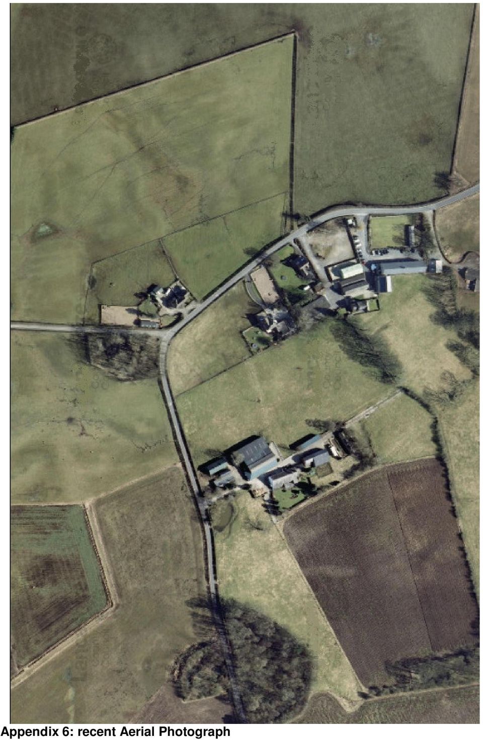
20 Appendix 6: recent Aerial Photograph
21 Appendix 7: Health Protection Agency Radon Map
22 Appendix 8: Building Research Establishment Radon Map 17
23 Appendix 9: Environment agency Data showing historic landfill presence at North Woods Hill Farm approximately 900m from the application site
Defence College of Technical Training. Former RAF Lyneham Geo-Environmental Report 32655 Appendix D: Preliminary Qualitative Risk Assessment
 Item No. Area/ Building Pathway to 1 Identified areas of / (redevelopment Ingestion Inhalation Severe Likely High SKM Enviros desk study highlights several known areas of significant historical. Areas
NATURAL RESOURCES & NATURAL FEATURES
 A3 NATURAL RESOURCES & NATURAL FEATURES INTRODUCTION This chapter will discuss the topography, geology, soils, and other natural features found in Casco Township. The identification of the natural features
Land contamination Information requirements for planning applications Version 0.05
 Land contamination Information requirements for planning applications Version 0.05 May 2015 Table of contents Introduction Outlines the intent of this guidance and defines key terms Required information
WEST LONDON PIPELINE AND STORAGE LIMITED AND UNITED KINGDOM OIL PIPELINES LIMITED
 WEST LONDON PIPELINE AND STORAGE LIMITED AND UNITED KINGDOM OIL PIPELINES LIMITED WLPS BUNCEFIELD REBUILD Flood Risk Assessment Green Lane Hemel Hempstead Hertfordshire HP2 7HZ September 2009 Prepared
Soil and Materials Engineers, Inc. Mark J. Quimby Project Consultant
 Soil and Materials Engineers, Inc. Mark J. Quimby Project Consultant Michigan Indiana Ohio www.sme-usa.com consultants in the environment, geosciences and materials OVERVIEW Site Description and History
1 Introduction. 1.1 Key objective. 1.2 Why the South Esk
 1 Introduction 1.1 Key objective The aim of this study is to identify and assess possible options for improving the quality of the river channel and habitats in the River South Esk catchment whilst helping
About Pure Earth and the Toxic Site Identification Program
 About and the Toxic Site Identification Program is a New York based not-for-profit organization that partners with governments, NGOs and community groups to solve life-threatening pollution problems in
FINAL PLAN OF REMEDIAL ACTION
 FINAL PLAN OF REMEDIAL ACTION 1000 FRENCH STREET SITE Wilmington, Delaware DE 1115 June 1999 Department of Natural Resources and Environmental Control Division of Air and Waste Management Site Investigation
Taylor Wimpey UK Ltd. December 2007
 Taylor Wimpey UK Ltd December 2007 QM Issue/revision Issue 1 Revision 1 Revision 2 Revision 3 Remarks Draft For Planning Date 3 August 2007 20 December 2007 Prepared by D Gooding P Barton Signature Checked
INFORMATION SHEET ORDER NO. R5-2011-XXXX TRIANGLE ROCK PRODUCTS, INC. FLORIN ROAD AGGREGATE PLANT SACRAMENTO COUNTY
 ORDER NO. R5-2011-XXXX INFORMATION SHEET Background Triangle Rock, Inc. (Discharger) submitted a Report of Waste Discharge (RWD) on 23 August 2010. The Discharger is expanding the mining operations at
APPLICATION FOR PLANNING PERMISSION FOR A SOIL TREATMENT FACILITY AT KINGS CLIFFE LANDFILL SITE, STAMFORD, NORTHAMPTONSHIRE
 APPLICATION FOR PLANNING PERMISSION FOR A SOIL TREATMENT FACILITY AT KINGS CLIFFE LANDFILL SITE, STAMFORD, NORTHAMPTONSHIRE DESIGN AND ACCESS STATEMENT Report Reference: AU/KC/SPH/1449/01/D&A/FIN Baddesley
STORMWATER POLLUTION PREVENTION PLAN TEMPLATE. 1.0 SITE DESCRIPTION 1.1 Project Name and Location Date
 STORMWATER POLLUTION PREVENTION PLAN TEMPLATE Disclaimer: This template was developed for guidance purposes only in an effort to assist Construction Storm Water permit applicants in meeting state and local
Vital Earth Composting Facility Flood Risk and Drainage Statement
 Vital Earth Flood Risk and Drainage Statement Final December 2011 Prepared for Vital Earth Ltd Revision Schedule Flood Risk and Drainage Statement December 2011 Rev Date Details Prepared by Reviewed by
Chapter 9: Water, Hydrology and Drainage Land West of Uttoxeter
 Chapter 9: Water, Hydrology and Drainage Land West of Uttoxeter ENVIRONMENTAL STATEMENT: VOLUME 1 9.1 INTRODUCTION 9.1.1 This Chapter considers the effects of the Project on surface water and groundwater
FLOOD RISK ASSESSMENT AND DRAINAGE STRATEGY
 FLOOD RISK ASSESSMENT AND DRAINAGE STRATEGY London Rd. WATERLOOVILE FOR McCarthy & Stone Ltd. July 2010 Such Salinger Peters Ltd 30558-1- Flood Risk Assessment & Drainage Strategy Contents Paragraph Page
Flood Risk Assessment and Drainage Impact Assessment: Planning Guidance for Developers
 Flood Risk Assessment and Drainage Impact Assessment: Planning Guidance for Developers Development and Regeneration Services Glasgow City Council 229 George Street Glasgow G1 1QU May 2011 1. Introduction...-
ENVIRONMENTAL REVIEW SCREENING QUESTIONS
 ENVIRONMENTAL REVIEW SCREENING QUESTIONS All applications to WHEDA are required to meet the Department of Housing and Urban Development s environmental compliance standards listed in 24 CFR Part 58. Your
STRATFORD CAMPUS, UNIVERSITY OF EAST LONDON ARCHAEOLOGICAL DESKTOP STUDY
 STRATFORD CAMPUS, UNIVERSITY OF EAST LONDON ARCHAEOLOGICAL DESKTOP STUDY TQ3945 8475 By Jo Udall Project Manager, Mark Turner 1/6/96 CONTENTS 1. INTRODUCTION 2. HISTORICAL AND ARCHAEOLOGICAL BACKGROUND
Settlement of Foundations on Expansive Clays Due to Moisture Demand of Trees CIGMAT 2008
 Settlement of Foundations on Expansive Clays Due to Moisture Demand of Trees CIGMAT 2008 Kenneth E. Tand, P.E. Practicing Geotechnical Engineer FRIEND OR FOE Trees are our friends. They extract carbon
Guidelines for Control of Water Runoff on Small Lots. Revised 6/09
 Guidelines for Control of Water Runoff on Small Lots Revised 6/09 Table of Contents Introduction and Purpose 3 Administrative Procedures 3 Plan Submittal Requirements 3 General Design Criteria 4 Dry Wells
(http://www.molevalley.gov.uk/media/pdf/c/r/srfa_-_updated_jnauary_2012.pdf
 Possible Submission about Water and Flooding (See maps 3a and 3b) From Mole Valley Local Development Framework: Strategic Flood Risk Assessment Update 2012 (http://www.molevalley.gov.uk/media/pdf/c/r/srfa_-_updated_jnauary_2012.pdf
FLOOD PLAIN DESIGNATION AND PROTECTION
 CITY OF RICHMOND FLOOD PLAIN DESIGNATION AND PROTECTION BYLAW NO. 8204 EFFECTIVE DATE - SEPTEMBER 8, 2008 CONSOLIDATED FOR CONVENIENCE ONLY This is a consolidation of the bylaws listed below. The amendment
COMMONWEALTH OF KENTUCKY CITY OF LONDON ORDINANCE NO. 2006-19 AN ORDINANCE ESTABLISHING EROSION AND STORM WATER CONTROL
 COMMONWEALTH OF KENTUCKY CITY OF LONDON ORDINANCE NO. 2006-19 AN ORDINANCE ESTABLISHING EROSION AND STORM WATER CONTROL For health, safety and welfare reasons, particularly due to problems experienced
THE RESULTS OF THE LITHUANIAN RADON SURVEY. Gendrutis Morkunas 1, Gustav Akerblom 2
 Radon in the Living Environment, 008 THE RESULTS OF THE LITHUANIAN RADON SURVEY Gendrutis Morkunas 1, Gustav Akerblom 2 1 Radiation Protection Centre, Kalvariju 153, LT-2042, Vilnius, Lithuania Tel. 3702
Former Barn, Pincents Manor Hotel, Pincents Lane, Tilehurst, West Berkshire
 Former Barn, Pincents Manor Hotel, Pincents Lane, Tilehurst, West Berkshire An Archaeological Watching Brief For Mr M Webb by Jennifer Lowe Thames Valley Archaeological Services Ltd Site Code PMH08/105
Preliminary Assessment
 Preliminary Assessment Bonebrake Theological Seminary Site Dayton Unit III Dayton, Ohio Prepared by: U.S. Army Corps of Engineers Buffalo District 1776 Niagara Street Buffalo, NY 14207-3199 September 5,
Prattsville Berm Removal Project. 1.0 Project Location
 Prattsville Berm Removal Project 1.0 Project Location The project site is located between the New York State Route 23 Bridge over the Schoharie Creek and the Schoharie Reservoir. The restoration plan encompassed
Assessment. Ian Uglow Technical Director, SLR Consulting iuglow@slrconsulting.com. 7 th October 2010
 Peat Stability Risk and Hazard Assessment Ian Uglow Technical Director, SLR Consulting iuglow@slrconsulting.com 7 th October 2010 What goes into a Peat Stability Risk Assessment? You will need: An understanding
CITY OF VINCENT CONSTRUCTION MANAGEMENT PLAN GUIDELINES
 CITY OF VINCENT CONSTRUCTION MANAGEMENT PLAN GUIDELINES INTRODUCTION What is a Construction Management Plan? The City of Vincent requires careful management of construction involving excavation and retention
WEATHERING, EROSION, AND DEPOSITION PRACTICE TEST. Which graph best shows the relative stream velocities across the stream from A to B?
 NAME DATE WEATHERING, EROSION, AND DEPOSITION PRACTICE TEST 1. The diagram below shows a meandering stream. Measurements of stream velocity were taken along straight line AB. Which graph best shows the
SECTION 31 20 00 EARTH MOVING
 SECTION 31 20 00 PART 1 - GENERAL 1.01 DESCRIPTION A. This Section describes the requirements for excavating, filling, and grading for earthwork at Parking Structure, new exit stair and as required to
FLOOD RISK AND SURFACE WATER DRAINAGE ASSESSMENT HILLHOUSE RESTORATION SITE, OFF JAMESON ROAD, THORNTON CLEVELEYS ON BEHALF OF NPL ESTATES
 FLOOD RISK AND SURFACE WATER DRAINAGE ASSESSMENT HILLHOUSE RESTORATION SITE, OFF JAMESON ROAD, THORNTON CLEVELEYS ON BEHALF OF NPL ESTATES Integra Consulting Engineers Limited NS / 2543 Fountain House
INFORMATION BULLETIN BUSINESS FLOOD PLANNING AND MITIGATION GUIDE ACE GLOBAL RISK ENGINEERING. Flood risk assessment. Introduction
 ACE GLOBAL RISK ENGINEERING INFORMATION BULLETIN BUSINESS FLOOD PLANNING AND MITIGATION GUIDE Introduction The most common cause of flooding is due to established water storage areas (natural and man-made)
In addition to the terms defined in this By-law, the following terms shall have the corresponding meanings for the purposes of this Section:
 Click here to access definitions SECTION 12 FLOODPLAIN LANDS 12.1 INTERPRETATION In addition to the terms defined in this By-law, the following terms shall have the corresponding meanings for the purposes
AGRICULTURAL BUILDING WITH PHOTOVOLTARIC SOLAR PANELS TO SOUTH FACING ROOF
 DC/2015/00494 AGRICULTURAL BUILDING WITH PHOTOVOLTARIC SOLAR PANELS TO SOUTH FACING ROOF LAND AT ONEN, ADJACENT TO B4233, NP25 5EN. RECOMMENDATION: APPROVE Case Officer: Elizabeth Bennett Date Registered:
LIQUID WASTE TREATMENT FACILITY MENDIS ROAD, HUDSON CREEK DRAFT GUIDELINES FOR A PUBLIC ENVIRONMENTAL REPORT
 LIQUID WASTE TREATMENT FACILITY MENDIS ROAD, HUDSON CREEK DRAFT GUIDELINES FOR A PUBLIC ENVIRONMENTAL REPORT Introduction The purpose of this Public Environmental Report (PER) is to provide the Government
Flash Flood Science. Chapter 2. What Is in This Chapter? Flash Flood Processes
 Chapter 2 Flash Flood Science A flash flood is generally defined as a rapid onset flood of short duration with a relatively high peak discharge (World Meteorological Organization). The American Meteorological
GUIDE TO SETTLEMENT OF CANTERBURY FLAT LAND CLAIMS
 GUIDE TO SETTLEMENT OF CANTERBURY FLAT LAND CLAIMS April 2013 i Introduction This guide focuses on repair methods for some of the types of land damage that occurred on flat residential land as a result
November 2006. General Notes. Tree Protection. Tree Protection and New Development Guidance Note
 Tree Protection and New Development Guidance Note November 2006 General Notes The retention and planting of trees within a development can add to the character and aesthetic value of a site whilst maintaining
SLOPE AND TOPOGRAPHY
 SLOPE AND TOPOGRAPHY What are Slope and Topography? Slope and topography describe the shape and relief of the land. Topography is a measurement of elevation, and slope is the percent change in that elevation
Risk-Based Decision Making for Site Cleanup
 July 2013 Risk-Based Decision Making for Site Cleanup The Oklahoma Department of Environmental Quality (DEQ) has adopted a risk based decision making process to provide a framework for determining cleanup
approval of matters specified in conditions; and The Town and Country Planning (Development Management Procedure) (Scotland) Regulations 2013
 (Scotland) Regulations 2013") Application for: planning permission; planning permission in principle; further applications; approval of matters specified in conditions; and mineral workings (if the planning authority do not have a
Application for: planning permission; planning permission in principle; further applications; approval of matters specified in conditions; and mineral workings (if the planning authority do not have a
WESTFIELD-WASHINGTON ADVISORY PLAN COMMISSION December 7, 2015 1512-SPP-24 & 1512-ODP-24
 Petition Number: Subject Site Address: Petitioner: Request: East side of Oak Road, north of 151 st Street Langston Development Co. Primary Plat and Overall Development Plan amendment review for Mapleridge
SUSTAINABLE URBAN DRAINAGE SYSTEMS
 overflow can lead into a permeable conveyance system to increase further the benefit and reduce the need for pipe systems. Pollutant removal rates have been shown to be high, with some pollutants being
1. Michigan Geological History Presentation (Michigan Natural Resources)
") 1. Michigan Geological History Presentation (Michigan Natural Resources) The Michigan Geological History Presentation provides an overview of the approximately 3 billion years of Earth Processes that the
1. Michigan Geological History Presentation (Michigan Natural Resources) The Michigan Geological History Presentation provides an overview of the approximately 3 billion years of Earth Processes that the
Guide to agrichemical use in Resource Management Plans Northland Region as at October 2011
 Guide to agrichemical use in Resource Management Plans Northland Region as at October 2011 Northland Regional Air Quality Plan Note: This guide is intended to assist users and applicators understanding
A guide to preventing structural damage
 A guide to preventing structural damage Home owners guide to planning landscaping and maintenance of foundations Structural damage can result from movement in clay soils caused by varying moisture conditions
COMPREHENSIVE PLAN SECTION B, ELEMENT 4 WATER RESOURCES. April 20, 2010 EXHIBIT 1
 COMPREHENSIVE PLAN SECTION B, ELEMENT 4 WATER RESOURCES April 20, 2010 EXHIBIT 1 ELEMENT 4 WATER RESOURCES TABLE OF CONTENTS 4.1 INTRODUCTION 4.2 GOALS AND POLICIES 4.2.A General Goals and Policies 1 4.2.B
The application site is on the edge of flood zones 1 and 2 with flood zone boundary cutting across part of the southern boundary of the site.
 Flood Risk Assessment Erection of Masjid/ Place of Worship, extended car parking following demolition of 11a Grafton Street & boundary treatment Land adjacent 11/ 11a Grafton Street, Preston, PR1 8JB 0723/
Liquid Effluent Treatment Plant (LETP) Land Clean-Up
 Land Clean-Up") Liquid Effluent Treatment Plant (LETP) Land Clean-Up Frequently Asked Questions What is proposed? Magnox Ltd is proposing to remove the redundant Liquid Effluent Treatment Plant (LETP) at Harwell and to
Liquid Effluent Treatment Plant (LETP) Land Clean-Up Frequently Asked Questions What is proposed? Magnox Ltd is proposing to remove the redundant Liquid Effluent Treatment Plant (LETP) at Harwell and to
Improper storage of fuel on construction sites will increase the risk of water pollution that may occur as a result of leaks or spills.
 WQ-10 Best Management Practice (BMP) Water Quality Protection Guideline Secondary Containment Design Standards Fuel Storage on Construction Sites According to the EPA, the majority of water pollution in
HEDDERMAN ENGINEERING, INC. www.heddermanengineering.com Office 281-355-9911, Fax 281-355-9903 office@heddermanengineering.com
 HEDDERMAN ENGINEERING, INC. www.heddermanengineering.com Office 281-355-9911, Fax 281-355-9903 office@heddermanengineering.com, 2011 TO: Mr. REF: CONDITION OF PROPERTY SURVEY Dear Mr. : At your request,
2. determining that land is not contaminated land and is suitable for any use, and hence can be removed from the CLR or EMR, as relevant.
 1. Purpose The Environmental Protection Act 1994 (EP Act) enables listing of land on the environmental management register (EMR) if either a notifiable activity has been or is being conducted, or the land
Sample Drawing Package for One and Two Family Dwelling Applications
 Sample Drawing Package for One and Two Family Dwelling Applications For a full list of submission requirements, refer to the relevant checklist for your application found on our website: http://vancouver.ca/home-property-development/application-forms-and-checklists.aspx
1800 Washington Boulevard, Baltimore, MD 21230-1718 www.mde.maryland.gov 410-537-3000 800-633-6101 TTY Users 800-735-2258 Larry Hogan, Governor Boyd
 ENVIRONMENTAL SITE DESIGN (ESD) REDEVELOPMENT EXAMPLES OCTOBER 2010 1800 Washington Boulevard, Baltimore, MD 21230-1718 www.mde.maryland.gov 410-537-3000 800-633-6101 TTY Users 800-735-2258 Larry Hogan,
How To Prepare A Geotechnical Study For A Trunk Sewer Project In Lincoln, Nebraska
 APPENDIX B Geotechnical Engineering Report GEOTECHNICAL ENGINEERING REPORT Preliminary Geotechnical Study Upper Southeast Salt Creek Sanitary Trunk Sewer Lincoln Wastewater System Lincoln, Nebraska PREPARED
Agricultural & Farm Development - The Planning Issues
 Agricultural & Farm Development - The Planning Issues Generally, smaller developments of an agricultural or forestry nature are exempt, however, larger developments do require planning permission. In addition,
N O T E S. Environmental Forensics. Identification of Natural Gas Sources using Geochemical Forensic Tools. Dispute Scenarios
 Environmental Forensics N O T E S V o l u m e 2 9 Identification of Natural Gas Sources using Geochemical Forensic Tools By Paul Boehm, Ph.D. and Tarek Saba, Ph.D. F o r m o r e i n f o r m a t i o n o
Proposed Terms of Reference for EIA studies
 1 Proposed Terms of Reference for EIA studies Base line data collection will be collected for the Post-Monsoon season 2016 (September to November 2016) in study area and 10 kms radius from project site.
BASIN MANAGEMENT OBJECTIVES CHEROKEE SUBINVENTORY UNIT
 BASIN MANAGEMENT OBJECTIVES CHEROKEE SUBINVENTORY UNIT Butte County Water Advisory Committee Member John Scott Contact Information Phone Number: (530) 533-8394 Email Address: john_lewis_scott@msn.com Description
Earth Science Landforms, Weathering, and Erosion Reading Comprehension. Landforms, Weathering, and Erosion
 Reading Comprehension Name 1 How many people have been to the Rocky Mountains or the Grand Canyon? When people go to visit these natural wonders, they may not realize that it took millions of years for
16. Storm water drainage
 16. Storm water drainage There are three principal ways to dispose of rainwater from roofs, courtyards and paved areas: storm water sewers, soakaways and collection in storage tanks. Storm water sewers,
THE APPRAISAL OF REAL ESTATE 3 RD CANADIAN EDITION BUSI 330
 THE APPRAISAL OF REAL ESTATE 3 RD CANADIAN EDITION BUSI 330 REVIEW NOTES by CHUCK DUNN CHAPTER 10 Copyright 2010 by the Real Estate Division and Chuck Dunn. All rights reserved ARE 3 rd EDITION REVIEW
Emergency Spillways (Sediment basins)
") Emergency Spillways (Sediment basins) DRAINAGE CONTROL TECHNIQUE Low Gradient Velocity Control Short-Term Steep Gradient Channel Lining Medium-Long Term Outlet Control Soil Treatment Permanent [1] [1]
Emergency Spillways (Sediment basins) DRAINAGE CONTROL TECHNIQUE Low Gradient Velocity Control Short-Term Steep Gradient Channel Lining Medium-Long Term Outlet Control Soil Treatment Permanent [1] [1]
Building Permit Application Packet. BUILDING CODES Adopted by La Plata County For Enforcement In The Unincorporated Areas Of La Plata County
 Building Permit Application Packet The purpose of Building Codes is to establish the minimum requirements to safe guard the public health, safety and general welfare through structural strength, means
APPENDIX F. RESIDENTIAL WATER QUALITY PLAN: ALLOWABLE BMP OPTIONS
 APPENDIX F. RESIDENTIAL WATER QUALITY PLAN: ALLOWABLE BMP OPTIONS The following section provides descriptions, advantages, limitations, and schematics of allowable best management practices (BMPs) for
BASILDON BOROUGH COUNCIL
 BASILDON BOROUGH COUNCIL Report to: Planning Committee December 05 PLANNING APPLICATION NO. 5/00699/FULL DEMOLITION OF ALL EXISTING OUTBUILDINGS AND REMOVAL OF ASSOCIATED LAWFUL USES AND TWO NO. RESIDENTIAL
ENVIRONMENTAL CODE OF PRACTICE FOR CONCRETE BATCH PLANT & ROCK WASHING OPERATIONS
 ENVIRONMENTAL CODE OF PRACTICE FOR CONCRETE BATCH PLANT & ROCK WASHING OPERATIONS PREPARED BY: DEPARTMENT OF ENVIRONMENT AND LANDS INDUSTRIAL ENVIRONMENTAL ENGINEERING DIVISION APRIL 16, 1992 - TABLE OF
FLOOD DAMAGE PREVENTION ORDINANCE
 FLOOD DAMAGE PREVENTION ORDINANCE SECTION 1.0 STATUTORY AUTHORIZATION, FINDINGS FO FACT, PURPOSE, AND OBJECTIVES 1.1 STATUTORY AUTHORIZATION The Legislature of the State of Washington has in RCW delegated
OSU Extension FACT SHEET
 OHIO STATE UNIVERSITY EXTENSION! OSU Extension FACT SHEET Ohio State University Extension, 2120 Fyffe Road, Columbus, OH 43210 Shale Oil and Gas Development Fact Sheet Series A Landowner s Guide to Understanding
ORDINANCE NO. 2013 -
 ORDINANCE NO. 2013 - AN ORDINANCE OF BREVARD COUNTY, FLORIDA AMENDING CHAPTER 62, LAND DEVELOPMENT REGULATIONS SECTION 62-2891, LOT DRAINAGE, AND CHAPTER 22 BUILDINGS AND BUILDING REGULATIONS, SECTION
Guidance Notes: GARDEN FLOODING
 Page 1 of 7 Guidance Notes: GARDEN FLOODING If you are unsure about anything within these notes then please contact the Flood Risk Management (FRM) team using the details at the end of this document. Water
Soil Cleanup Goals. Minnesota Department of Agriculture Pesticide and Fertilizer Management Division. Guidance Document 19
 This document is made available electronically by the Minnesota Legislative Reference Library as part of an ongoing digital archiving project. http://www.leg.state.mn.us/lrl/lrl.asp Minnesota Department
Igneous rocks formed when hot molten material (magma) cools and hardens (crystallizes).
 cools and hardens (crystallizes).") Objectives You will learn about how the land of North Dakota was formed. Introduction North Dakota is a wonderful place to live. Have you ever though about how it was formed? To answer that question, you
Objectives You will learn about how the land of North Dakota was formed. Introduction North Dakota is a wonderful place to live. Have you ever though about how it was formed? To answer that question, you
RESOURCE RECYCLING SOLUTIONS LTD
 RESOURCE RECYCLING SOLUTIONS LTD Iron House Farm, Lancaster Road, Out Rawcliffe, Preston, Lancashire, PR3 6BP Accident Management Plan Issue 01 Walker Resource Management Ltd - www.walkerom.com QC Document
Pollution Incident Response Plan
 Pollution Incident Response Plan Introduction Schmidt Quarries is committed to ensuring all aspects of our quarrying activities comply with the environmental legislative requirements in NSW. This Pollution
Recommendations for future developments
 C Recommendations for future developments C.1 Reducing flood risk through site layout and design C.1.1 C.1.2 Flood risk should be considered at an early stage in deciding the layout and design of a site
Proposed Construction of Basement Flood Risk Assessment. 35 Edwardes Square London W8 6HH
 Proposed Construction of Basement Flood Risk Assessment 35 Edwardes Square London W8 6HH 1 Introduction This FRA has been carried out in accordance with the National Planning Policy Statement (NPPF), the
Holly Lodge, Nuneaton Road, Mancetter PAP/2015/0659. 8 Harpers Lane, Mancetter PAP/2015/0669
 Oak Tree Farm PAP/2015/0436 Agricultural Building to provide stock pen for Alpacas. Permission Granted Holly Lodge, Nuneaton Road, Mancetter PAP/2015/0659 Part of 21 day experiment No objection Pitched
CHAPTER 2 HYDRAULICS OF SEWERS
 CHAPTER 2 HYDRAULICS OF SEWERS SANITARY SEWERS The hydraulic design procedure for sewers requires: 1. Determination of Sewer System Type 2. Determination of Design Flow 3. Selection of Pipe Size 4. Determination
A. Describe the existing drainage patterns on-site as shown on Map I, including any potential flooding and erosion problems.
 19. STORMWATER MANAGEMENT A. Describe the existing drainage patterns on-site as shown on Map I, including any potential flooding and erosion problems. The majority of the approximately ±500 acre Property
Storm Water Management Requirements for Construction Projects Less than One Acre
 Storm Water Management Requirements for Construction Projects Less than One Acre Purpose: UC Irvine s Phase II Small MS4 Storm Water Permit requires construction projects less than one acre in size to
Sustainable Drainage Systems (SUDS) A guide for developers
 A guide for developers") Sustainable Drainage Systems (SUDS) A guide for developers We are the Environment Agency. It s our job to look after your environment and make it a better place for you, and for future generations. Your
Sustainable Drainage Systems (SUDS) A guide for developers We are the Environment Agency. It s our job to look after your environment and make it a better place for you, and for future generations. Your
Land Disturbance, Erosion Control and Stormwater Management Checklist. Walworth County Land Conservation Department
 Land Disturbance, Erosion Control and Stormwater Management Checklist Walworth County Land Conservation Department The following checklist is designed to assist the applicant in complying with the Walworth
Mechanical Biological Treatment Facility
 Mechanical Biological Treatment Facility Former Britannia Zinc Site, Avonmouth Environmental Statement Non Technical Summary Non Technical Summary July 09 New Earth Solutions Group Ltd Mechanical Biological
Format for scrutinising the Hill Station Building Applications ( Current File No. 24911/2001-HSBA) The application shall be accompanied by
 The application shall be accompanied by") Format for scrutinising the Hill Station Building Applications ( Current File No. 24911/2001-HSBA) 1 2 3 4 5 I. Tamil Nadu Districts Municipalities (Hill Stations) Building Rules 1993. Rules Required Available
Format for scrutinising the Hill Station Building Applications ( Current File No. 24911/2001-HSBA) 1 2 3 4 5 I. Tamil Nadu Districts Municipalities (Hill Stations) Building Rules 1993. Rules Required Available
PLANNING SERVICES UNIT
 SUPPLEMENTARY PLANNING GUIDANCE DEVELOPMENT INVOLVING HORSES PLANNING SERVICES UNIT 1. INTRODUCTION 1.1 This document provides supplementary planning guidance on development involving horses, which is
City of Valdosta Land Development Regulations. Table of Contents
 TITLE 1 ADMINISTRATION Chapter 102 General Provisions 102-1 Title 102-2 Purpose 102-3 Authority 102-4 Jurisdiction 102-5 Application of Ordinance 102-6 Relationship to Existing Ordinances 102-7 Powers
MEMORANDUM. Further discussion regarding the Community s solid waste facility is described further in this memorandum.
 MEMORANDUM File: Sanikiluaq Improvement of the Existing Wastewater Treatment Facility To: Government of Nunavut Department of Community and Government Services Attention: Mr. Grigor Hope,, Project Officer
DOÑA ANA COUNTY DESIGN STORM CRITERIA GUIDELINES FOR COMMERCIAL AND RESIDENTIAL SITES. Run-off Analysis Methods
 DOÑA ANA COUNTY DESIGN STORM CRITERIA GUIDELINES FOR COMMERCIAL AND RESIDENTIAL SITES Run-off Analysis Methods This document sets forth the minimum design, technical criteria and specifications for the
RADON AND HEALTH. INFORMATION SHEET October 2002. What is radon and where does it come from?
 INFORMATION SHEET October 2 FINAL RADON AND HEALTH What is radon and where does it come from? Radon is a natural radioactive gas without odour, colour or taste. It cannot be detected without special equipment.
UNDERGROUND TELECOMMUNICATIONS CABLES ACROSS PRIVATE LAND
 FACT SHEET TELEPHONE 0800 327 646 I WEBSITE WWW.FEDFARM.ORG.NZ UNDERGROUND TELECOMMUNICATIONS CABLES ACROSS PRIVATE LAND BACKGROUND The Rural Broadband Initiative envisages substantially improved broadband
Standard Operating Procedures for Flood Preparation and Response
 Standard Operating Procedures for Flood Preparation and Response General Discussion Hurricanes, tropical storms and intense thunderstorms support a conclusion that more severe flooding conditions than
Weathering, Erosion, and Soils. Weathering and Erosion. Weathering and Erosion
 Weathering, Erosion, and Soils 1 The Grand Canyon, a landscape shaped by weathering and erosion 2 Weathering vs. erosion Types of weathering Physical Chemical Rates of weathering and erosion Climate Rock
1 in 30 year 1 in 75 year 1 in 100 year 1 in 100 year plus climate change (+30%) 1 in 200 year
 1 in 200 year") Appendix C1 Surface Water Modelling 1 Overview 1.1 The Drain London modelling was designed to analyse the impact of heavy rainfall events across each London borough by assessing flow paths, velocities
Appendix C1 Surface Water Modelling 1 Overview 1.1 The Drain London modelling was designed to analyse the impact of heavy rainfall events across each London borough by assessing flow paths, velocities
GLOSSARY OF TERMS CHAPTER 11 WORD DEFINITION SOURCE. Leopold
 CHAPTER 11 GLOSSARY OF TERMS Active Channel The channel that contains the discharge Leopold where channel maintenance is most effective, sediment are actively transported and deposited, and that are capable
QUATERNARY DATING METHODS 1: RELATIVE DATING TECHNIQUES
 QUATERNARY DATING METHODS 1: RELATIVE DATING TECHNIQUES Objectives: In this lab we will examine relative dating methods used to date Quaternary glacial deposits. After this lab you should be able to: 1)
PREVENTION. City of Orem FLOOD DAMAGE PREVENTION 10-1-1
 City of Orem FLOOD DAMAGE PREVENTION 10-1-1 CHAPTER 10. Article 10-1. Article 10-2. Article 10-3. Article 10-4. Article 10-5. FLOOD DAMAGE PREVENTION Purposes Definitions General Provisions Administration
SITE-SPECIFIC BEST MANAGEMENT PRACTICES (BMP) PLAN REVIEW CHECKLIST
 PLAN REVIEW CHECKLIST") This checklist may be used by applicants for encroachment permits, and contractors in development of Site- Specific BMP Plans for projects. plan reviewers will use this checklist to review the Site-Specific
This checklist may be used by applicants for encroachment permits, and contractors in development of Site- Specific BMP Plans for projects. plan reviewers will use this checklist to review the Site-Specific
Outlet stabilization structure
 Overview of Sedimentation and Erosion Control Practices Practice no. 6.41 Outlet stabilization structure Erosion at the outlet of channels, culverts, and other structures is common, and can cause structural