Utilising the Virtual World for Urban Planning and Development
|
|
|
- Dana Abigail Johnston
- 7 years ago
- Views:
Transcription
1 FIG 2014 Utilising the Virtual World for Urban Planning and Development David JONAS, Australia

2 Paper Outline 7 steps in the Virtual Urban Citymodel Process: 1. User Needs Assessment 2. Data Quality 3. Data Acquisition 4. Visualisation 5. Functionality 6. Maintenance 7. Proposal Dissemination Case Studies.

3 1. User Needs Assessment 1. Identify potential users 2. Understand their needs 3. Clarify their intended functionality Utilise User Stories: I am a [user definition] and I would like to Classify User Stories into: Must have, Should have, Could have, Wont have Get signoff by Project Sponsors.

4 2. Data Quality Review the Data required to meet User Needs: 1. Accuracy 2. Precision 3. Reliability 4. Currency 5. Completeness 6. Reality.

5 2. Data Quality Reality and Accuracy: Everybody wants higher degrees of Reality, but some users need higher degrees of Accuracy. Higher Accuracy User Stories dominate with references to court hearings, legal planning decisions, measurement functionality, references to other datasets and other applications where it has to be right. Higher Reality User Stories dominate with references to visual appeal, aesthetics, public consultation, visual amenity, and other applications where it has to look right.

6 2. Data Quality Reality and Accuracy: Everybody wants higher degrees of Reality, but some users need higher degrees of Accuracy.

7 3. Data Acquisition Review the Data Acquisition methodologies against the Data Quality criteria: 1. Satellite imagery 2. Aerial photography 3. Oblique aerial photography 4. Airborne LiDAR 5. Terrestrial LiDAR 6. Terrestrial imagery 7. Existing building footprints 8. As built plans 9. UAVs.

8 3. Data Acquisition Satellite Imagery Pros: Little (or no) site access required Significant archives available Often cost efficient Cloudy areas can be captured without paying standby aircraft charges Aerial Photography Pros: very high resolution available archives may be available versatility with bespoke capture rapid and efficient capture once on site Cons: Low resolution (0.5m at best) poor resolution for capturing façades archive imagery may be out of date Cons: ATC & possibly military permits reqd poor geometry for capturing façades archive imagery may be out of date higher startup costs
 poor resolution for capturing façades archive imagery may be out of date Cons: ATC & possibly military permits reqd poor geometry for")
9 3. Data Acquisition Oblique Aerial Photography Pros: simultaneous nadir & oblique imagery defines façade textures and geometry supports crisp vector definition good definition of upper building parts access to all sides of every building rapid and efficient capture once on site Airborne LiDAR Pros: simultaneous LiDAR and imagery good definition of upper building parts access to all sides of every building rapid and efficient capture once on site Cons: ATC & possibly military permits many flightlines for dense definition poor definition of lower building parts higher startup costs Cons: geometry inferred from point data building lines confused by data noise crisp building lines need high density poor definition of lower building parts higher startup costs

10 3. Data Acquisition Terrestrial LiDAR Pros: simultaneous LiDAR and imagery efficient mobile (vehicle) capture good definition of lower building parts high point density available lower startup costs Cons: less access to rear side of buildings may require entering private property lower accuracy in urban canyons poor definition of upper building parts buildings obscured by fences or trees facades obscured by traffic Terrestrial Imagery Pros: inexpensive GPS/attitude cameras skilled labor not required can access buildings by foot or vehicle lower startup costs Cons: provides poor building geometry less access to rear side of buildings may require entering private property buildings obscured by fences or trees

11 3. Data Acquisition Existing Building footprints Pros: no site access required low cost ensure consistency with other data layers Cons: footprints may have variable accuracy no shape in the building upper stories building height required from elsewhere building texture required from elsewhere As built Plans Pros: no site access required (for this project) lower cost Cons: rarely complete dataset available often inaccurate building location building texture required from elsewhere

12 3. Data Acquisition Design Plans Pros: no site access required allows proposals to be assessed good for maintaining existing citymodels Cons: doesn t support building existing cities Pros: small areas can be updated inexpensively UAVs Cons: Public safety / liability concerns of UAVs in cities Can become expensive over larger areas

13 3. Data Acquisition Aerial versus Terrestrial Cityscape Capture 1. Aerial Capture provides: 1. Greater access to more building facades 2. Greater efficiency in data capture 3. Definition of rooflines 4. More perspectives on more facades 5. Required perspective for more planning purposes 2. But is limited by: 1. Shadows 2. Building awnings 3. Vegetation 4. Urban canyon.

14 3. Data Acquisition Aerial versus Terrestrial Cityscape Capture 1. Terrestrial Capture provides: 1. Clearer access to prominent facades 2. Higher resolution 2. But is limited by: 1. Facades accessible by vehicle or on foot 2. Poor building geometry definition (other than streetscape) 3. Building awnings 4. Vegetation 5. Less efficiency in data capture over large areas 6. traffic.
 3. Building awnings 4. Vegetation 5.")
15 3. Data Acquisition Aerial versus Terrestrial Cityscape Capture

16 3. Data Acquisition Aerial versus Terrestrial Cityscape Capture Capture geometry and overall textures from the air Supplement aerial geometry with terrestrial textures.

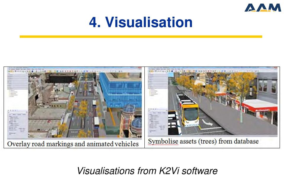
17 4. Visualisation Allows stakeholders to understand complex environments and attributes:

18 4. Visualisation Allows stakeholders to understand complex environments and attributes:

19 4. Visualisation Allows stakeholders to understand complex environments and attributes:

20 4. Visualisation Visualisations from K2Vi software
21 5. Functionality Allows stakeholders to understand complex environments and attributes:
22 5. Functionality Allows stakeholders to understand complex environments and attributes:
23 5. Functionality Allows stakeholders to understand complex environments and attributes:
24 6. Maintenance Need to maintain confidence in Urban Model: 1. Planning Process mandate planning applications include new models 2. Specific Update use planning process to identify changes for survey 3. Complete Remap remap city at periodic intervals 4. Partial Remap remap highly dynamic areas (between complete remap)
25 7. Proposal Dissemination City of Melbourne uses Facebook to help disseminate planning schemes to stakeholders:
26 Managing Urbanisation Case Studies
27 Urban Landuse Planning Case Studies
28 Closing Work from the Whole to the Part: so that each component can play an appropriate role in achieving the agreed result. Process: uncover and clarify the needs to be met design a Virtual World to meet those needs define the functionality to utilise the Virtual World outline the data to support the functionality establish maintenance programs to provide enduring confidence in the Virtual World.
3D GIS: It s a Brave New World
 3D GIS: It s a Brave New World Reida ELWANNAS, United Arab Emirates Key words: 3D Models, CityGML, GIS SUMMARY For the past several decades we have been enjoying the power of GIS. The introduction of 2.5D
RESOLUTION MERGE OF 1:35.000 SCALE AERIAL PHOTOGRAPHS WITH LANDSAT 7 ETM IMAGERY
 RESOLUTION MERGE OF 1:35.000 SCALE AERIAL PHOTOGRAPHS WITH LANDSAT 7 ETM IMAGERY M. Erdogan, H.H. Maras, A. Yilmaz, Ö.T. Özerbil General Command of Mapping 06100 Dikimevi, Ankara, TURKEY - (mustafa.erdogan;
3D Point Cloud Analytics for Updating 3D City Models
 3D Point Cloud Analytics for Updating 3D City Models Rico Richter 25 th May 2015 INSPIRE - Geospatial World Forum 2015 Background Hasso Plattner Institute (HPI): Computer Graphics Systems group of Prof.
RIEGL VZ-400 NEW. Laser Scanners. Latest News March 2009
 Latest News March 2009 NEW RIEGL VZ-400 Laser Scanners The following document details some of the excellent results acquired with the new RIEGL VZ-400 scanners, including: Time-optimised fine-scans The
OBLIQUE AERIAL PHOTOGRAPHY TOOL FOR BUILDING INSPECTION AND DAMAGE ASSESSMENT
 OBLIQUE AERIAL PHOTOGRAPHY TOOL FOR BUILDING INSPECTION AND DAMAGE ASSESSMENT A. Murtiyoso 1, F. Remondino 2, E. Rupnik 2, F. Nex 2, P. Grussenmeyer 1 1 INSA Strasbourg / ICube Laboratory, France Email:
Understanding Raster Data
 Introduction The following document is intended to provide a basic understanding of raster data. Raster data layers (commonly referred to as grids) are the essential data layers used in all tools developed
High Resolution RF Analysis: The Benefits of Lidar Terrain & Clutter Datasets
 0 High Resolution RF Analysis: The Benefits of Lidar Terrain & Clutter Datasets January 15, 2014 Martin Rais 1 High Resolution Terrain & Clutter Datasets: Why Lidar? There are myriad methods, techniques
Specialised Data Specifications
 Version 4.6.0 26 01 March 2015 SPECIALISED DATA SPECIFICATION have been created to document standards for specific types of spatial data that have requirements that may differ from, or be additional, to
COMPARISON OF AERIAL IMAGES, SATELLITE IMAGES AND LASER SCANNING DSM IN A 3D CITY MODELS PRODUCTION FRAMEWORK
 COMPARISON OF AERIAL IMAGES, SATELLITE IMAGES AND LASER SCANNING DSM IN A 3D CITY MODELS PRODUCTION FRAMEWORK G. Maillet, D. Flamanc Institut Géographique National, Laboratoire MATIS, Saint-Mandé, France
The following was presented at DMT 14 (June 1-4, 2014, Newark, DE).
.") DMT 2014 The following was presented at DMT 14 (June 1-4, 2014, Newark, DE). The contents are provisional and will be superseded by a paper in the DMT 14 Proceedings. See also presentations and Proceedings
DMT 2014 The following was presented at DMT 14 (June 1-4, 2014, Newark, DE). The contents are provisional and will be superseded by a paper in the DMT 14 Proceedings. See also presentations and Proceedings
REGISTRATION OF LASER SCANNING POINT CLOUDS AND AERIAL IMAGES USING EITHER ARTIFICIAL OR NATURAL TIE FEATURES
 REGISTRATION OF LASER SCANNING POINT CLOUDS AND AERIAL IMAGES USING EITHER ARTIFICIAL OR NATURAL TIE FEATURES P. Rönnholm a, *, H. Haggrén a a Aalto University School of Engineering, Department of Real
Teaching and Learning Strategies for 3D Urban and Landscape Modelling
 Teaching and Learning Strategies for 3D Urban and Landscape Modelling Martin SMITH, Andrew BURTON, and Nikolaos KOKKAS, United Kingdom Key words: 3D modelling, visualization, teaching, learning SUMMARY
Statistical Bulletin. Internet Access - Households and Individuals, 2012. Key points. Overview
 Statistical Bulletin Internet Access - Households and Individuals, 2012 Coverage: GB Date: 24 August 2012 Geographical Area: Country Theme: People and Places Key points In 2012, 21 million households in
Pima Regional Remote Sensing Program
 Pima Regional Remote Sensing Program Activity Orthophoto GIS Mapping and Analysis Implementing Agency Pima Association of Governments (Tucson, Arizona area Metropolitan Planning Organization) Summary Through
MAPPING MINNEAPOLIS URBAN TREE CANOPY. Why is Tree Canopy Important? Project Background. Mapping Minneapolis Urban Tree Canopy.
 MAPPING MINNEAPOLIS URBAN TREE CANOPY Why is Tree Canopy Important? Trees are an important component of urban environments. In addition to their aesthetic value, trees have significant economic and environmental
Remote Sensing Method in Implementing REDD+
 Remote Sensing Method in Implementing REDD+ FRIM-FFPRI Research on Development of Carbon Monitoring Methodology for REDD+ in Malaysia Remote Sensing Component Mohd Azahari Faidi, Hamdan Omar, Khali Aziz
IMPERVIOUS SURFACE MAPPING UTILIZING HIGH RESOLUTION IMAGERIES. Authors: B. Acharya, K. Pomper, B. Gyawali, K. Bhattarai, T.
 IMPERVIOUS SURFACE MAPPING UTILIZING HIGH RESOLUTION IMAGERIES Authors: B. Acharya, K. Pomper, B. Gyawali, K. Bhattarai, T. Tsegaye ABSTRACT Accurate mapping of artificial or natural impervious surfaces
Urban Land Use Data for the Telecommunications Industry
 Urban Land Use Data for the Telecommunications Industry Regine Richter, Ulla Weingart & Tobias Wever GAF AG Arnulfstr. 197 D-80634 Munich & Ulrike Kähny E-Plus Mobilfunk GmbH & Co. KG E-Plus Platz D-40468
Lidar 101: Intro to Lidar. Jason Stoker USGS EROS / SAIC
 Lidar 101: Intro to Lidar Jason Stoker USGS EROS / SAIC Lidar Light Detection and Ranging Laser altimetry ALTM (Airborne laser terrain mapping) Airborne laser scanning Lidar Laser IMU (INS) GPS Scanning
GIS DATA CAPTURE APPLICATIONS MANDLI COMMUNICATIONS http://www.mandli.com
 GIS DATA CAPTURE APPLICATIONS MANDLI COMMUNICATIONS http://www.mandli.com Mandli Communications is a leader in specialized digital imaging equipment. Since 1983, the company has produced a range of imaging,
IP-S2 HD. High Definition 3D Mobile Mapping System
 IP-S2 HD High Definition 3D Mobile Mapping System Integrated, turnkey solution High Density, Long Range LiDAR sensor for ultimate in visual detail High Accuracy IMU and DMI Odometry for positional accuracy
Photogrammetric Point Clouds
 Photogrammetric Point Clouds Origins of digital point clouds: Basics have been around since the 1980s. Images had to be referenced to one another. The user had to specify either where the camera was in
WHAT IS GIS - AN INRODUCTION
 WHAT IS GIS - AN INRODUCTION GIS DEFINITION GIS is an acronym for: Geographic Information Systems Geographic This term is used because GIS tend to deal primarily with geographic or spatial features. Information
Submitted to: Submitted by: Department of Geology and Mineral Industries 800 NE Oregon Street, Suite 965 Portland, OR 97232
 LIDAR REMOTE SENSING DATA COLLECTION DEPARTMENT OF F GEOLOGY AND MINERAL INDUSTRIES CRATER LAKE, OREGON NOVEMBER 30, 2010 Submitted to: Department of Geology and Mineral Industries 800 NE Oregon Street,
2002 URBAN FOREST CANOPY & LAND USE IN PORTLAND S HOLLYWOOD DISTRICT. Final Report. Michael Lackner, B.A. Geography, 2003
 2002 URBAN FOREST CANOPY & LAND USE IN PORTLAND S HOLLYWOOD DISTRICT Final Report by Michael Lackner, B.A. Geography, 2003 February 2004 - page 1 of 17 - TABLE OF CONTENTS Abstract 3 Introduction 4 Study
Geospatial Cloud Computing - Perspectives for
 Geospatial Cloud Computing - Perspectives for Startups and Open Source Projects The Cases of OpenWebGlobe and 3D Vision Mobile Mapping for Urban Infrastructure Management Prof. Dr. Stephan Nebiker FHNW
IMPLICIT SHAPE MODELS FOR OBJECT DETECTION IN 3D POINT CLOUDS
 IMPLICIT SHAPE MODELS FOR OBJECT DETECTION IN 3D POINT CLOUDS Alexander Velizhev 1 (presenter) Roman Shapovalov 2 Konrad Schindler 3 1 Hexagon Technology Center, Heerbrugg, Switzerland 2 Graphics & Media
'Developments and benefits of hydrographic surveying using multispectral imagery in the coastal zone
 Abstract With the recent launch of enhanced high-resolution commercial satellites, available imagery has improved from four-bands to eight-band multispectral. Simultaneously developments in remote sensing
Table of Contents 1. INTRODUCTION 2 2. DEFINITION 4 3. UAS CLASSIFICATION 6 4. REGULATORY PRINCIPLES 16 5. INTERACTION WITH AIR TRAFFIC CONTROL 16
 FOREWORD Table of Contents 1. INTRODUCTION 2 2. DEFINITION 4 3. UAS CLASSIFICATION 6 4. REGULATORY PRINCIPLES 16 5. INTERACTION WITH AIR TRAFFIC CONTROL 16 6. SENSE AND AVOID ( required for applicants
Visual Sensing and Analytics for Construction and Infrastructure Management
 Visual Sensing and Analytics for Construction and Infrastructure Management Academic Committee Annual Conference Speaker Moderator: Burcu Akinci, Carnegie Mellon University 2015 CII Annual Conference August
AUTOMATIC CLASSIFICATION OF LIDAR POINT CLOUDS IN A RAILWAY ENVIRONMENT
 AUTOMATIC CLASSIFICATION OF LIDAR POINT CLOUDS IN A RAILWAY ENVIRONMENT MOSTAFA ARASTOUNIA March, 2012 SUPERVISORS: Dr. Ir. S.J. Oude Elberink Dr. K. Khoshelham AUTOMATIC CLASSIFICATION OF LIDAR POINT
Wildfires pose an on-going. Integrating LiDAR with Wildfire Risk Analysis for Electric Utilities. By Jason Amadori & David Buckley
 Figure 1. Vegetation Encroachments Highlighted in Blue and Orange in Classified LiDAR Point Cloud Integrating LiDAR with Wildfire Risk Analysis for Electric Utilities Wildfires pose an on-going hazard
ADVANTAGES AND DISADVANTAGES OF THE HOUGH TRANSFORMATION IN THE FRAME OF AUTOMATED BUILDING EXTRACTION
 ADVANTAGES AND DISADVANTAGES OF THE HOUGH TRANSFORMATION IN THE FRAME OF AUTOMATED BUILDING EXTRACTION G. Vozikis a,*, J.Jansa b a GEOMET Ltd., Faneromenis 4 & Agamemnonos 11, GR - 15561 Holargos, GREECE
Application of airborne remote sensing for forest data collection
 Application of airborne remote sensing for forest data collection Gatis Erins, Foran Baltic The Foran SingleTree method based on a laser system developed by the Swedish Defense Research Agency is the first
How To Make An Orthophoto
 ISSUE 2 SEPTEMBER 2014 TSA Endorsed by: CLIENT GUIDE TO DIGITAL ORTHO- PHOTOGRAPHY The Survey Association s Client Guides are primarily aimed at other professionals such as engineers, architects, planners
Photogrammetry and 3D Car Navigation
 Strassenburg-Kleciak 309 Photogrammetry and 3D Car Navigation MAREK STRASSENBURG-KLECIAK, Hamburg ABSTRACT The technological development of recent hardware systems of car navigation systems allows the
5. project evaluation
 5. project evaluation CONTENTS 5.1 EVALUATION...5.2 5.2 TIMING...5.2 5.3 UNDERTAKING EVALUATION...5.3 5.4 EVALUATION METHODS...5.3 5.4.1 Asking people...5.3 5.4.2 Physical methods...5.5 COASTAL PLANNING
LIDAR and Digital Elevation Data
 LIDAR and Digital Elevation Data Light Detection and Ranging (LIDAR) is being used by the North Carolina Floodplain Mapping Program to generate digital elevation data. These highly accurate topographic
Big Data and Analytics: Getting Started with ArcGIS. Mike Park Erik Hoel
 Big Data and Analytics: Getting Started with ArcGIS Mike Park Erik Hoel Agenda Overview of big data Distributed computation User experience Data management Big data What is it? Big Data is a loosely defined
SIAMA. SIAMA Asset Management Technologies Advanced Inspection Technology
 Prolonging Infrastructure Assets Life Asset Management Technologies Advanced Inspection Technology Smart Infrastructure Asset Management Australia () Research and Development Research & Development company
How To Fuse A Point Cloud With A Laser And Image Data From A Pointcloud
 REAL TIME 3D FUSION OF IMAGERY AND MOBILE LIDAR Paul Mrstik, Vice President Technology Kresimir Kusevic, R&D Engineer Terrapoint Inc. 140-1 Antares Dr. Ottawa, Ontario K2E 8C4 Canada paul.mrstik@terrapoint.com
Get Your Business on Google Maps - It's Easy
 Feature Get your business on the map 70 Issue 44 Quarter Four 2013 In this social, local, mobile world we live in, being able to pinpoint where we are, what is in our immediate vicinity and how to get
The YellowScan system: A test on the oppida of Nages/Roque de Viou (Languedoc, France) Tristan Allouis, PhD Research and Development, L'Avion Jaune
 Tristan Allouis, PhD Research and Development, L'Avion Jaune") The YellowScan system: A test on the oppida of Nages/Roque de Viou (Languedoc, France) Tristan Allouis, PhD Research and Development, L'Avion Jaune L'Avion Jaune : Earth observation data provider UAVs
The YellowScan system: A test on the oppida of Nages/Roque de Viou (Languedoc, France) Tristan Allouis, PhD Research and Development, L'Avion Jaune L'Avion Jaune : Earth observation data provider UAVs
ACCURACY ASSESSMENT OF BUILDING POINT CLOUDS AUTOMATICALLY GENERATED FROM IPHONE IMAGES
 ACCURACY ASSESSMENT OF BUILDING POINT CLOUDS AUTOMATICALLY GENERATED FROM IPHONE IMAGES B. Sirmacek, R. Lindenbergh Delft University of Technology, Department of Geoscience and Remote Sensing, Stevinweg
Point clouds colorized by elevation of downtown Detroit, MI.
 Point clouds colorized by elevation of downtown Detroit, MI. Mobile Mapping: Fact, Fiction, or Fad? If the question What is mobile mapping and when did it start? was asked to ten different people in the
House Code. House Code
 1 Application This Code will apply in assessing material change of use and/or building work for a house. 2 Using this Code In using this Code reference should also be made to Section 1.1 How to use the
The process components and related data characteristics addressed in this document are:
 TM Tech Notes Certainty 3D November 1, 2012 To: General Release From: Ted Knaak Certainty 3D, LLC Re: Structural Wall Monitoring (#1017) rev: A Introduction TopoDOT offers several tools designed specifically
Resolution Enhancement of Photogrammetric Digital Images
 DICTA2002: Digital Image Computing Techniques and Applications, 21--22 January 2002, Melbourne, Australia 1 Resolution Enhancement of Photogrammetric Digital Images John G. FRYER and Gabriele SCARMANA
Image Analysis CHAPTER 16 16.1 ANALYSIS PROCEDURES
 CHAPTER 16 Image Analysis 16.1 ANALYSIS PROCEDURES Studies for various disciplines require different technical approaches, but there is a generalized pattern for geology, soils, range, wetlands, archeology,
POLICY P350.5 Trees on Development Sites and Street Verges. Relevant Management Practice Nil Relevant Delegation Delegations DC 342 and DM 342
 POLICY P350.5 Trees on Development Sites and Street Verges Strategic Plan Goal 3 Environmental Management Relevant Management Practice Nil Relevant Delegation Delegations DC 342 and DM 342 Rationale Trees
CITY OF SUFFOLK, VIRGINIA GIS DATA DISTRIBUTION AND PRICING POLICY
 CITY OF SUFFOLK, VIRGINIA GIS DATA DISTRIBUTION AND PRICING POLICY 1 The City of Suffolk has invested a large amount of effort into the development of a Citywide Geographic Information System (GIS). The
Technology Trends In Geoinformation
 Technology Trends In Geoinformation Dato Prof. Sr Dr. Abdul Kadir Bin Taib Department of Survey and Mapping Malaysia (JUPEM) Email: drkadir@jupem.gov.my www.jupem.gov.my NGIS 2008 3 rd. National GIS Conference
IP-S2 Compact+ 3D Mobile Mapping System
 IP-S2 Compact+ 3D Mobile Mapping System 3D scanning of road and roadside features Delivers high density point clouds and 360 spherical imagery High accuracy IMU options without export control Simple Map,
Methane to Markets Oil and Natural Gas Technology Transfer Workshop
 Methane to Markets Oil and Natural Gas Technology Transfer Workshop Airborne Differential Absorption Lidar (DIAL) Detection and Measurement of Fugitive Emissions Steven Stearns ANGEL Service ITT Space
(1) define the objectives and intended use of the maps and spatial data and
 define the objectives and intended use of the maps and spatial data and") Mapping coastal seabed habitats in Tasmania: development and integration of remote sensing techniques within a hierarchical framework Alan Jordan Vanessa Halley Miles Lawler Richard Mount Project Planning
Mapping coastal seabed habitats in Tasmania: development and integration of remote sensing techniques within a hierarchical framework Alan Jordan Vanessa Halley Miles Lawler Richard Mount Project Planning
EVALUATION OF AIRBORNE LIDAR DIGITAL TERRAIN MAPPING FOR HIGHWAY CORRIDOR PLANNING AND DESIGN
 Waheed Uddin Director, Center for Advanced Infrastructure Technology, Carrier Hall 203 The University of Mississippi, University, MS 38677-1848, USA cvuddin@olemiss.edu KEY WORDS: Terrain, mapping, airborne,
COMPARISON OF OBJECT BASED AND PIXEL BASED CLASSIFICATION OF HIGH RESOLUTION SATELLITE IMAGES USING ARTIFICIAL NEURAL NETWORKS
 COMPARISON OF OBJECT BASED AND PIXEL BASED CLASSIFICATION OF HIGH RESOLUTION SATELLITE IMAGES USING ARTIFICIAL NEURAL NETWORKS B.K. Mohan and S. N. Ladha Centre for Studies in Resources Engineering IIT
Section 2: Ordnance Survey Large Scales Map Data
 Section 2: Ordnance Survey Large Scales Map Data The Quality of Ordnance Survey Large Scales Data How good is an Ordnance Survey map? How much can it be relied upon to show what is really on the ground?
Digital Remote Sensing Data Processing Digital Remote Sensing Data Processing and Analysis: An Introduction and Analysis: An Introduction
 Digital Remote Sensing Data Processing Digital Remote Sensing Data Processing and Analysis: An Introduction and Analysis: An Introduction Content Remote sensing data Spatial, spectral, radiometric and
Landsat Monitoring our Earth s Condition for over 40 years
 Landsat Monitoring our Earth s Condition for over 40 years Thomas Cecere Land Remote Sensing Program USGS ISPRS:Earth Observing Data and Tools for Health Studies Arlington, VA August 28, 2013 U.S. Department
Information Contents of High Resolution Satellite Images
 Information Contents of High Resolution Satellite Images H. Topan, G. Büyüksalih Zonguldak Karelmas University K. Jacobsen University of Hannover, Germany Keywords: satellite images, mapping, resolution,
automatic road sign detection from survey video
 automatic road sign detection from survey video by paul stapleton gps4.us.com 10 ACSM BULLETIN february 2012 tech feature In the fields of road asset management and mapping for navigation, clients increasingly
Map World Forum Hyderabad, India Introduction: High and very high resolution space images: GIS Development
 Very high resolution satellite images - competition to aerial images Dr. Karsten Jacobsen Leibniz University Hannover, Germany jacobsen@ipi.uni-hannover.de Introduction: Very high resolution images taken
DATA INTEGRATION FROM DIFFERENT SOURCES TO CREATE 3D VIRTUAL MODEL
 DATA INTEGRATION FROM DIFFERENT SOURCES TO CREATE 3D VIRTUAL MODEL A. Erving, P. Rönnholm, and M. Nuikka Institute of Photogrammetry and Remote Sensing, Department of Surveying, Helsinki University of
3.0 Table of Development Note: This table must be read in conjunction with the explanation provided in Part 5, Division 1, Chapter 2 Using Domains.
 Part 5 Division 2 Chapter 2 Domains Domains Park Living 1.0 Intent The purpose of this domain is to provide a variety of opportunities for low density residential activity within areas of semi-rural landscapes,
Community Tree Inventory: Data Collection
 USDA FOREST SERVICE NORTHEAST CENTER FOR URBAN & COMMUNITY FORESTRY www.umass.edu/urbantree Community Tree Inventory: Data Collection An Introduction - July 2002 United States Department of Agriculture
Mobile Network Base Station Design Guide User Manual
 Mobile Network Base Station Design Guide User Manual Prepared for the Mobile Carriers Forum and the Design and Innovation Programme Taskforce February 2008 Consultant Contact: Nicole Halsey, Director Urban
Digital Image Increase
 Exploiting redundancy for reliable aerial computer vision 1 Digital Image Increase 2 Images Worldwide 3 Terrestrial Image Acquisition 4 Aerial Photogrammetry 5 New Sensor Platforms Towards Fully Automatic
Learn How to Fly a Gatewing X-100 and Why
 The Trimble Gatewing Rapid mapping tool. TSA Discussion Group, 7 Nov 2012 Anthony Mills, Trimble Agenda: Why UAS? Gatewing Results Deliverables Accuracy UK Regulation Why UAS? Economic Hazardous & Hard-to-Reach
USING MOBILE LIDAR TO SURVEY A RAILWAY LINE FOR ASSET INVENTORY INTRODUCTION
 USING MOBILE LIDAR TO SURVEY A RAILWAY LINE FOR ASSET INVENTORY a Michael Leslar, Sales and Marketing Support Engineer b Gordon Perry, Senior Project Manager b Keith McNease, Principal a Optech Incorporated
Living Options Varsity Lakes, Australia
 Living Options Varsity Lakes, Australia Summary Varsity Lakes is a master planned community located at the Gold Coast, Queensland that comprises 4,500 homes. The development is based around Lake Orr and
Projeto Redentor White Paper
 Projeto Redentor White Paper Projeto Redentor: High-resolution 3D modelling of large, hard-to-reach objects How can one create a highly accurate 3D model of large objects, in hard-to-reach locations, for
Files Used in this Tutorial
 Generate Point Clouds Tutorial This tutorial shows how to generate point clouds from IKONOS satellite stereo imagery. You will view the point clouds in the ENVI LiDAR Viewer. The estimated time to complete
3D City Modelling of Istanbul Historic Peninsula by Combination of Aerial Images and Terrestrial Laser Scanning Data
 4th EARSel Workshop on Remote Sensing for Developing Countries/GISDECO 8, Istanbul, Turkey, June 4-7, 2008 3D City Modelling of Istanbul Historic Peninsula by Combination of Aerial Images and Terrestrial
LiDAR REMOTE SENSING
 LiDAR REMOTE SENSING LOS OSOS CALIFORNIA 5/18/2011 (Updated 2/19/2013) Prepared for: Prepared by: WSI Corvallis Office 517 SW 2 nd St, Suite 400 Corvallis, OR 97333 LIDAR REMOTE SENSING DATA COLLECTION:
The Use of Geographic Information Systems in Risk Assessment
 The Use of Geographic Information Systems in Risk Assessment With Specific Focus on the RiVAMP Methodology Presented by Nadine Brown August 27, 2012 Climate Studies Group Mona Climate Change Workshop Presentation
Synthetic Aperture Radar: Principles and Applications of AI in Automatic Target Recognition
 Synthetic Aperture Radar: Principles and Applications of AI in Automatic Target Recognition Paulo Marques 1 Instituto Superior de Engenharia de Lisboa / Instituto de Telecomunicações R. Conselheiro Emídio
Keystone Image Management System
 Image management solutions for satellite and airborne sensors Overview The Keystone Image Management System offers solutions that archive, catalogue, process and deliver digital images from a vast number
The Chillon Project: Aerial / Terrestrial and Indoor Integration
 The Chillon Project: Aerial / Terrestrial and Indoor Integration How can one map a whole castle efficiently in full 3D? Is it possible to have a 3D model containing both the inside and outside? The Chillon
Supporting Online Material for Achard (RE 1070656) scheduled for 8/9/02 issue of Science
 scheduled for 8/9/02 issue of Science") Supporting Online Material for Achard (RE 1070656) scheduled for 8/9/02 issue of Science Materials and Methods Overview Forest cover change is calculated using a sample of 102 observations distributed
Supporting Online Material for Achard (RE 1070656) scheduled for 8/9/02 issue of Science Materials and Methods Overview Forest cover change is calculated using a sample of 102 observations distributed
SESSION 8: GEOGRAPHIC INFORMATION SYSTEMS AND MAP PROJECTIONS
 SESSION 8: GEOGRAPHIC INFORMATION SYSTEMS AND MAP PROJECTIONS KEY CONCEPTS: In this session we will look at: Geographic information systems and Map projections. Content that needs to be covered for examination
INTEGRATED GEOPHYSICAL AND REMOTE SENSING STUDIES ON GROTTA GIGANTE SHOW CAVE (TRIESTE ITALY) P. Paganini, A. Pavan, F. Coren, A.
 P. Paganini, A. Pavan, F. Coren, A.") INTEGRATED GEOPHYSICAL AND REMOTE SENSING STUDIES ON GROTTA GIGANTE SHOW CAVE (TRIESTE ITALY) P. Paganini, A. Pavan, F. Coren, A. Fabbricatore Aerial lidar survey - strumentation Piper Seneca II - PA34
INTEGRATED GEOPHYSICAL AND REMOTE SENSING STUDIES ON GROTTA GIGANTE SHOW CAVE (TRIESTE ITALY) P. Paganini, A. Pavan, F. Coren, A. Fabbricatore Aerial lidar survey - strumentation Piper Seneca II - PA34
Opportunities for Mapping Rooftop Solar Energy using LiDAR
 Opportunities for Mapping Rooftop Solar Energy using LiDAR An Introduction for BC Local Governments March 2013 Thoreau Rory Tooke Opportunities for Mapping Rooftop Solar Energy using LiDAR An Introduction
VCS REDD Methodology Module. Methods for monitoring forest cover changes in REDD project activities
 1 VCS REDD Methodology Module Methods for monitoring forest cover changes in REDD project activities Version 1.0 May 2009 I. SCOPE, APPLICABILITY, DATA REQUIREMENT AND OUTPUT PARAMETERS Scope This module
Laserscanning experiments and experiences in Norway. Håvard Tveite NOF & UMB Jan R. Lien UiB
 Laserscanning experiments and experiences in Norway Håvard Tveite NOF & UMB Jan R. Lien UiB 1 Experiences WOC 2010, Trondheim Special purpose laser scanning by Terratec Contours only 1.25 meter contour
Databases for 3D Data Management: From Point Cloud to City Model
 Databases for 3D Data Management: From Point Cloud to City Model Xavier Lopez, Ph.D. Senior Director, Spatial and Graph Technologies Oracle Program Agenda Approach: Spatially-enable the Enterprise Oracle
One Survey One Hundred Solutions. TLidar in Africa
 TLidar in Africa Africa Geospatial Forum The Survey Profession 35 Years of Change Johannesburg 19 August 2015 Norman Banks Change & Progress! The reasonable man adapts himself to the world; the unreasonable
Architectural Design Standards Example Guide DESIGN STANDARDS EXAMPLE GUIDE
 Architectural Design Standards Example Guide DESIGN STANDARDS EXAMPLE GUIDE Commercial, Professional Office, and Public Facility Developments Purpose This Guide offers examples to clarify and explain the
Optimisation of complex LIDAR & oblique imagery for real time visualisation of cityscapes.
 y Optimisation of complex LIDAR & oblique imagery for real time visualisation of cityscapes. Karl Jones Cassidian Ltd Karl. Jones @ Cassidian. com Abstract. 2 subsidiaries of EADS, CASSIDIAN and ASTRIUM
The use of Satellite Remote Sensing for Offshore Environmental Benchmarking
 The use of Satellite Remote Sensing for Offshore Environmental Benchmarking Michael King Fugro NPA Limited Fugro NPA (Formerly Nigel Press Associates) World leading Satellite Remote Sensing & Geoscience
LiDAR for vegetation applications
 LiDAR for vegetation applications UoL MSc Remote Sensing Dr Lewis plewis@geog.ucl.ac.uk Introduction Introduction to LiDAR RS for vegetation Review instruments and observational concepts Discuss applications
LAR-IAC4 Status and User Group Meeting. October 8, 2015
 LAR-IAC4 Status and User Group Meeting October 8, 2015 Agenda LARIAC Imagery Update LARIAC Status Update LARIAC Update and Training Schedule LARIAC Data Access Methods Additional Derived Data User Presentations
Pros and Cons of Alternative Origin- Destination Passive Data Collection Methods
 Pros and Cons of Alternative Origin- Destination Passive Data Collection Methods presented by Robert G. Schiffer, AICP, Stantec Consulting, Inc. December 8, 2015 Background Methods Pros & Cons Acknowledgements
Improving Land Administration in Brazil From Rural to National Cadastre
 Improving Land Administration in Brazil From Rural to National Cadastre Thiago Marra thiago.marra@incra.gov.br Kilder Barbosa kilder.barbosa@bhe.incra.gov.br Eduardo Aguilar de Oliveira (presenter) eduardo.oliveira@mda.gov.br
The 7 th International Scientific Conference DEFENSE RESOURCES MANAGEMENT IN THE 21st CENTURY Braşov, November 15 th 2012
 The 7 th International Scientific Conference DEFENSE RESOURCES MANAGEMENT IN THE 21st CENTURY Braşov, November 15 th 2012 COMMUNICATION ISSUES OF UAV 1 INTEGRATION INTO NON 1 st. Lt. Gábor Pongrácz, ATM
THE OBJECT-BASED APPROACH FOR URBAN LAND USE CLASSIFICATION USING HIGH RESOLUTION SATELLITE IMAGERY (A CASE STUDY ZANJAN CITY)
") Proceedings of the 4th GEOBIA, May 7-9, 2012 - Rio de Janeiro - Brazil. p.678 THE OBJECT-BASED APPROACH FOR URBAN LAND USE CLASSIFICATION USING HIGH RESOLUTION SATELLITE IMAGERY (A CASE STUDY ZANJAN CITY)
Proceedings of the 4th GEOBIA, May 7-9, 2012 - Rio de Janeiro - Brazil. p.678 THE OBJECT-BASED APPROACH FOR URBAN LAND USE CLASSIFICATION USING HIGH RESOLUTION SATELLITE IMAGERY (A CASE STUDY ZANJAN CITY)
3D MODELING OF LARGE AND COMPLEX SITE USING MULTI-SENSOR INTEGRATION AND MULTI-RESOLUTION DATA
 3D MODELING OF LARGE AND COMPLEX SITE USING MULTI-SENSOR INTEGRATION AND MULTI-RESOLUTION DATA G. Guidi 1, F. Remondino 2, 3, M. Russo 1, F. Menna 4, A. Rizzi 3 1 Dept.INDACO, Politecnico of Milano, Italy
Mapping Solar Energy Potential Through LiDAR Feature Extraction
 Mapping Solar Energy Potential Through LiDAR Feature Extraction WOOLPERT WHITE PAPER By Brad Adams brad.adams@woolpert.com DESIGN GEOSPATIAL INFRASTRUCTURE November 2012 Solar Energy Potential Is Largely
3D Data Management From Point Cloud to City Model GeoSmart Africa 2016, Cape Town
 3D Data Management From Point Cloud to City Model GeoSmart Africa 2016, Cape Town Albert Godfrind Spatial Solutions Architect ORACLE Corporation April 13, 2016 Copyright 2014 Oracle and/or its affiliates.
12-Step Guidance for NPS Vegetation Inventories Updated March 1 2013
 Executive Summary 12-Step Guidance for NPS Vegetation Inventories Updated March 1 2013 The Vegetation Inventory is a cooperative effort between the NPS I&M Program and the U.S. Geological Survey to classify,