Developing Squaw Valley. Another Approach. Judy Carini
|
|
|
- Kristina Short
- 7 years ago
- Views:
Transcription
1 Developing Squaw Valley Another Approach By Judy Carini

2 Table of Contents Introduction Population Visual Analysis The Village Land Use Districts and Height Restrictions Project #1 The Shirley Canyon Parcels: Project #2 The Olympic Plaza Parcel and Surrounding Area Project #3 The Village Parcels Project #4 The Entrance Parcel Traffic, Parking and Circulation A Specific Plan was not intended for Squaw Valley The Specific Plan - Appendix A, B, C, D and E

3 Introduction I am currently a member of the Squaw Valley Design Review Committee. However, the comments and suggestions below are my own. I am exercising my right to speak as a Squaw Valley property owner and concerned citizen. Although these opinions are my own, they are shared by many within the community. Squaw Valley Real Estate, LLC and Squaw Valley Resort, LLC, hereafter called KSL, have taken legal ownership of the parcels discussed in this document. Nonetheless, they have an obligation to be responsible stewards of their land, and to respect the history, lifestyle and visual characteristics that make Squaw Valley a desirable place to visit, to own property and to live. Below I offer alternatives to KSL s proposal and Specific Plan that are in compliance with the 1983 Squaw Valley General Plan and Land Use Ordinance and are appropriate and sensitive to the needs of our community and our delicate environment. My approach allows for the development of approximately acres in four project areas. Statements included in this document that are direct quotes, either from the Placer County General Plan, the Placer County Zoning Ordinance or the 1983 Squaw Valley General Plan and Land Use Ordinance will be highlighted in blue. Thank you for taking the time to read my proposal. Judy Carini The Placer County General Plan is says; The Placer County General Plan consists of two types of documents: the Countywide General Plan and a set of more detailed community plans covering specific areas of the unincorporated county. Community plans, adopted in the same manner as the Countywide General Plan, provide a more detailed focus on specific geographic areas within the unincorporated County. The goals and policies contained in the community plans supplement and elaborate upon, but do not supersede, the goals and policies of the Countywide General Plan. The 1983 Squaw Valley General Plan and Land Use Ordinance is Squaw Valley s Community Plan. Squaw Valley is more than just a community; it s also a ski area and a resort. The three need to work together. One part cannot succeed without the other. While the 1983 SVGPLUO is over 30 years old, it addresses all three aspects of the Valley and most of what is included still applies today. Minor changes and additions could easily bring the plans up-to-date. During the planning process leading to the 1983 Squaw Valley General Plan and Land Use Ordinance there was a clear consensus that a sense of pride and involvement in maintaining and improving the visual and environmental quality of the Valley must be developed at a local level. As a result, the SV Municipal Advisory Committee and the SV Design Review Committee were developed as a long-term mechanism to ensure a high degree of local home rule. Placer County committed itself to cooperating and working with the MAC and DRC to assure that no new developments within the valley were permitted without the opportunity for a full evaluation by and recommendation from the MAC and/or the DRC. 1

4 The SVDRC was created to guide and influence further development with a goal to maintain and protect the visual and environmental quality of the valley. To aid the DRC, a set of design guidelines were developed by the Squaw Valley MAC and Placer County to be used as a standard against which all projects will be evaluated during the design review process. The Design Guidelines provide a far greater degree of direction to the project proponents and at the same time allow for greater input from the local people. My goal with this proposal is to: 1. Provide KSL and Placer County with alternative ideas, comments and suggestions for development that are in compliance with the Placer County Zoning Ordinance and the 1983 Squaw Valley General Plan and Land Use Ordinance. 2. Encourage KSL to create a project that complies with the intent of the SVGPLUO while incorporating new ideas and concepts, such as water conservation, drought and fire resistant plants, areas dedicated to open space, and a plan that is a more realistic approach for future development. 3. Address the January 2014 Draft of the Specific Plan, concentrating on some but not all areas that either include incorrect information, material that does not apply to Squaw or a process that may be in conflict with the SVGPLUO. 4. Ensure that, as required by the SVGPLUO, the spirit of Squaw Valley isn t undermined by arbitrary, unthoughtful design and/or negatively impacted by over population. 5. Remind Placer County of its commitment, as stated in the SVGPLUO, to cooperate and work with the MAC and the DRC to assure that no new developments within the valley are permitted without the opportunity for a full evaluation by and recommendation from the MAC and/or DRC. Population The 1983 SVGPLUO states, On page 5, The plan allows growth in Squaw Valley to reach a seasonal-peak, overnight residential population of about 11-12,000. On page 64, It has been found by the County that the total number of bedrooms in a project is a more accurate determinant of potential impacts on public services and resources than are dwelling units due to the wide variation in size of a single dwelling unit. For the purpose of calculating the number of bedrooms in a project, rooms which potentially serve as bedrooms shall be counted as such (including dens, studies, libraries, lofts, etc.). The Village at Squaw Valley Specific Plan January 2014 Draft States: On page 3.8, that the Plan proposes 771 additional units. It is not clear if they have included dens, studies, libraries, or lofts, etc., in their conversion rate of 2.0 bedrooms/unit. Therefore, to calculate a more accurate additional population under their proposal, I will assume that each unit will have a sofa bed, so the conversion rate shall be 3.0 bedrooms per unit with two people per bedroom. This will result in an increase to the current peak overnight population of 4626 people. 2

5 Before any development plan can be approved by Placer County, a study should be made to determine the existing seasonal-peak, overnight residential population in the Valley. Calculating the current existing peak overnight population is difficult. I have taken two approaches. 1. Beginning in 1972, with a population of 2800, I have used a 3.96% yearly growth rate and have calculated in ten year intervals. The result is a 2014 estimated peak overnight population of 11,476 people. 2. When adding the number of condos, homes, apartment, and other housing units in the valley along with an estimated bedroom count, the result is a 2014 estimated peak overnight population of 12,348 people. Taking the average of the two and adding 4626 people from the KSL project will result in a peak overnight population in the Valley of approximately 16,538. Again, the SVGPLUO allows for a growth rate to reach a seasonal peak residential overnight population of 11-12,000. Therefore, it s reasonable that any further development within the Valley could result in over population. Visual Analysis The SVGPLUO states, on page 17, The visual characteristics of the Squaw Valley environment are one of its most important attributes. Visually, there are at least 5 critical view areas in Squaw that need protecting. The parcel height limits included in the SVGPLUO were intended to protect, among other things, the wonderful mountain and valley views within the valley. However, further protections could now be justified, including stronger restrictions on Forest Recreation and Conservation Preserve Zoning areas. The 5 areas are: 1. The Entrance area is the gateway to the Valley. It is our visitor s first impression. It is critical that development on the north side of the road be exceptionally attractive and inviting. 2. The view looking down the meadow toward the ski hill is the most photographed view in the valley. This view is an icon of Squaw Valley. Even KSL uses photos from this view point in their advertisements. It is essential that this view be protected. 3. The view along the Squaw Valley Main Road, looking across the meadow to the mountains and up the ski hill is also critical to maintain visual continuity within the valley. 4. The view from the intersection of Squaw Valley Road and Christy Lane, through the intersection of Squaw Valley Road and Chamonix Court is also critical because it gives our visitors their first real view at the village and a closer look at the ski hill beyond. 5. The view of the ski hill, Granite Chief, Shirley Canyon and the mountains from various locations within the existing and proposed Village is also important to maintain the visual continuity within the Valley. 3

6 The SVGPLUO states, On page 18, Development should not be visually dominant in any area outside the commercial core. On page 19, No further encroachments of buildings, impervious surfaces, or other development activity (other than that permitted in the Land Use Ordinance) should occur on the lands designated in the Plan as Conservation Preserve. On page 20, State Highway 89 and Squaw Valley Road were both designated as scenic roadways. The Village In the past 30 years, there have been substantial changes within the Truckee/North Lake Tahoe area, including Squaw Valley. The SVGPLUO focused on development within the Valley and did not consider the development of destination resorts outside the Valley. Squaw is geographically handicapped, while other areas, like Northstar, have a far greater potential for a destination resort type development simply because of their available land. The Village in Squaw Valley, though not as grand as some may want, may be the perfect fit for Squaw. It is a year around village, with activities throughout the summer and fall and skiing through the winter and spring. A true village is not defined by how many or how high its buildings are. It s defined by its visual and environmental quality. More development may be possible but it should be based on quality, not quantity. Squaw is a special place and deserves more than a cookie cutter mass and scale development. Land Use Districts and Height Restrictions The SVGPLUO established eight specific Land Use Districts in Squaw Valley, which are briefly described below. 1. Conservation Preserve Land Use District Maximum permitted height of structures is 30 feet On page 99 it says, In order to accomplish the goals of the SVGP it is necessary to recognize areas within the plan where the intent is to maintain the land in as near its natural state as is reasonable and to carefully regulate the use of these areas. 2. Forest Recreation District Maximum permitted height of structures is 30 feet On page 98 it says, This land use district is intended to retain the general character of the forest environment while at the same time permitting active recreational development. 3. Low Density Residential Maximum permitted height of structures is 30 feet On page 94 it says, The intent of this district is to create areas within which land uses are restricted to single-family dwellings and related uses. 4

7 4. High Density Residential Maximum average height of a building is 35 feet On page 95 it says, In creating this district it is the intent of the County to provide for a variety of residential development relying on the planned unit development concept to create desirable living environments. 5. Alpine Commercial Land Use District Maximum average height of a building is 35 feet On page 93 it says, This Land Use District is intended to provide lands for commercial use as a part of ski-related recreation uses on the ski mountain. 6. Heavy Commercial District Maximum average height of a building is 35 feet On page 92 it says, This district is necessary to provide areas specifically for heavy equipment maintenance and storage as well as construction related shop space. Such uses should not be visually obtrusive. The land in this district is not located adjacent to major travelled ways, but is located to conveniently serve the ski area and adjoining developed areas. 7. Entrance Commercial District Maximum average height of a building is 35 feet On page 89, it says, The entrance to Squaw Valley is important because it will provide the visitor with their first impression of the quality of development and the activities and opportunities that lie within. 8. Village Commercial District On page 87 it says, There shall be no specific height limitations in this district, but height limits shall be set for particular developments through the design review process. On page 84 it says, Development occurring within this district must be equally oriented to the ski hill and the major pedestrian/vehicular access points. 5

8
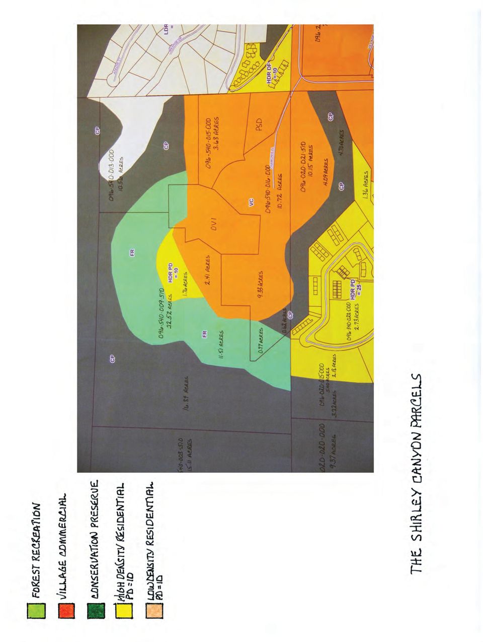
9 Project #1 The Shirley Canyon Parcels: Acres 4.70 Acres CP 4.09 Acres VC 1.36 Acres HDR PD= Acres 9.33 Acres VC 0.77 Acres FR 0.62 Acres CP Acres VC Acres 2.41 Acres VC 1.76 Acres HDR PD= Acres FR Acres CP There are approximately acres in the Shirley Canyon area that are available for development. The Shirley Canyon parcels are at the west end of the Valley and are generally defined as the parcels near OVI and adjacent to Chanomix Place. This location has a great deal of potential for a creative, exclusive development. It s not as windy as the Village and main parking lot area, has great sun, and is away from the music, noise and hustle bustle of the Village and ski area yet close enough to be part of the action within minutes. There are a number of zoning designations on these parcels, and some development restrictions could be beneficial for the protection of the nearby delicate environment. There are old growth trees, areas with streams and delicate springs that feed into the aquifer, and the Shirley Canyon trailheads leading to one of the most popular and beautiful hikes in Placer County. Zoning changes, as noted below, could protect this sensitive and beautiful area for generations to come. Parcel is approximately acres acres are zoned Conservation Preserve and should be maintained in as near its natural state as is reasonable acres of this parcel is zoned HDR PD=25. This area is environmentally sensitive and rezoning to Conservation Preserve is recommended acres are zoned Village Commercial and are available for development. Parcel is approximately acres acres are zoned Forest Recreation. Re-zoning to Conservation Preserve is recommended acres are zoned Conservation Preserve and should be maintained in as near its natural state as is reasonable acres are zoned Village Commercial and are available for development. 6

10 Parcel is approximately acres are zoned Village Commercial and are available for development. Parcel is approximately acres acres are zoned Conservation Preserve and should be maintained in as near its natural state as is reasonable acres are zoned Forest Recreation. Re-zoning to Conservation Preserve is recommended acres are zoned HDR PD=10. Although presently zoned for development, this area is environmentally sensitive. Re-zoning to Conversation Preserve is recommended acres are zoned Village Commercial and are available for development. Again, there are approximately acres in the Shirley Canyon area that are available for development. This area provides an opportunity to develop a true Planned Unit Development. The focus here could be on families and amenities designed specifically for their enjoyment. This area should be self-contained. It could provide a strong family friendly and activity oriented atmosphere, and be a place where families can settle in and be comfortable. It should be skier friendly too, with ski tuning and equipment storage, a shuttle to access the lifts, and tickets available on site. In the summer there could be an activities director on site whose job it is to plan fun and exciting adventures outside the valley or up on the mountain. This area could include the Recreation Center or MAC, but rather than the large elaborate plan KSL now has, it could be just large enough to accommodate the guests in this development and others from within the Valley. A membership arrangement could be incorporated so the residential community of the Valley can also access the facilities. It would not be open to the public but would be available to visitors staying in the valley. (It would be worth a trip to Old Greenwood to see their recreation center.) To complement and enhance the public enjoyment of this area, building heights could vary, depending on the style and location of the buildings. Low rooflines and a contemporary style could be utilized to keep the structures as low as possible. Final approval of the heights of the buildings rests with the Squaw Valley DRC. Squaw Creek, which borders this area, could be enhanced so it can be accessed and enjoyed. The small maintenance buildings and yard at the back corner of this area, along the creek, could be re-located to the Heavy Commercial District at the base of Red Dog, or, could be re-zoned to Heavy Commercial, as long as the creek is protected from contamination. The four main hiking trailheads going up the north side of Shirley Canyon should be enhanced and better maintained. Public bathrooms at one or two of these trailheads would be a valuable addition. 7

11

12 Project #2 The Olympic Plaza Parcel and Surrounding Area Acres 0.38 Acres VC 0.74 Acres FR Acres VC Acres 0.24 Acres VC 1.33 Acres FR Acres 0.41 Acres FR 0.40 Acres VC Acres VC Acres 3.23 Acres VC 4.29 Acres FR There are 4.33 acres in the Olympic Plaza area available for development. This area is truly in the heart of the village and could substantially contribute to the creation of a true village atmosphere. Parcel is approximately 1.12 acres acres are zoned Village Commercial. The current use is appropriate for this zoning acres are zoned Forest Recreation. The current use is appropriate for this zoning. Parcel is approximately 0.03 acres and is zoned Village Commercial. Parcel is approximately 1.57 acres acres are zoned Village Commercial. The current use is appropriate acres are zoned Forest Recreation. The current use is appropriate. Parcel is 0.81 acres acres is zoned Forest Recreation. The current use is appropriate acres is zoned Village Commercial. The current use is appropriate. Parcel is approximately 0.05 acres and is zoned Village Commercial. Parcel is approximately 7.52 acres acres are zoned Village Commercial. The current use is appropriate acres are zoned Forest Recreation. The current use is appropriate. 8

13 Again, there are 4.33 acres in this area that are available for development. Parcel , which is 3.23 acres, is where The Olympic House is located. This area is in the heart of the action, both summer and winter. The Olympic House is old and functionally absolute yet KSL has no plans to redevelop this area. Plumbjack, which is next door, has come forward with a plan that includes demolishing their existing buildings, rebuilding their hotel and adding condos in the back. KSL is encouraged to consider doing something similar on this parcel. This is the perfect location for a hotel, ski services, a day lodge with a food court, a relocated Le Chamois, and a small ice rink in the center courtyard. The ice rink could be open to the Village and if the buildings are kept low, would protect the great view looking up the ski hill. There is an abundance of open space in the surrounding area, which works nicely for activities and events. KSL has done a good job with the KT Deck area. The open area by the Funitel is large, attractive and useful. Not far away is the smaller, more intimate gathering area by Starbucks and Fireside. Adding another courtyard with the ice rink, the day lodge and the food court in the Olympic House area, with tables and chairs everywhere, will pull it all together. The doctor s offices could be relocated to the west end of Kids World, leaving that area open and a perfect spot for a children s play area, with swings and slides, etc. The area by the Funitel, where the lovely Toyotas are now, could be turned into a permanent stage, with heaters, speakers and lights. Bands could be brought in on a regular basis, during ski season and during the summer, day and night and not just on the weekends. This would draw people in, encourage them to grab a snack at the food court, ice skate to the music and maybe stay for dinner. With the trampoline close by and a kid s play area by the member s locker rooms, you could have everything you need to create a real village atmosphere. 9

14

15 Project #3 The Village Parcels Acres Acres FR 0.27 Acres HC Acres 2.67 Acres FR 3.19 Acres VC Acres 5.34 Acres FR 4.06 Acres VC Acres VC Acres VC Acres CP Acres VC Acres Acres VC 1.11 Acres HC Acres VC Acres Acres FR 1.19 Acres HC Acres VC Acres 1.32 Acres VC 0.65 Acres FR There are approximately acres in the Village parcels area. Of the acres, there are approximately 5.75 acres available for development. These parcels are defined generally as the parcels in the main parking lot, around the existing Village and up the ski hill and are generally in the Village Commercial Land Use District. The zoning in this area includes Village Commercial (VC), Forest Recreation (FR), Heavy Commercial (HC) and Conservation Preserve (CP). The focus of this area is and should remain the ski mountain and skiing activities. The skiing terrain is the single most important recreational attraction in Squaw Valley. The land near the ski lifts and ski hill should be developed in a way that compliments and enhances the skier experience. 10

16 In the summer, the focus for this area shifts to weekend events, large sport events, concerts and other crowd pleasing activities. The general layout of the Village and adjacent ski hill compliments these activities. This should not change. There is also a Heavy Commercial Land Use District, zoned Heavy Commercial (HC) in this area, located at the base of Red Dog. This is an appropriate location for the maintenance yard and storage area for ski related maintenance and equipment storage, and the snow making facility. This also should not change. The California and Nevada buildings, because of their history with the 1960 Olympics and their classic mid-century modern architecture, should be preserved. Removing one will diminish their significance and compromise the historic value of the remaining building. Together, they create a visual bond with the past that is architecturally attractive and unique. Signs explaining their architecture and history would enhance their importance and create more interest in the Olympic Heritage of the valley. Development in this general area needs to be carefully planned. There are two very important concerns. The first is the view, which is extremely important for the preservation of the soul of Squaw Valley. The second is the surface parking, which is extremely important for the preservation of the day skiers and the survival of the ski area. Parcel is approximately acres acres are zoned Forest Recreation. The height limit for this area is 30. This land is intended to retain the general character of the forest environment while at the same time permitting active recreational development acres are zoned Heavy Commercial. The height limit for this area is 35. It is the County s intent in creating this district to establish areas within Squaw where primarily service oriented commercial uses and uses specifically related to the operation of a major ski resort can be carried out. Parcel is approximately 5.86 acres acres are zoned Forest Recreation. The height limit for this area is 30. This land is intended to retain the general character of the forest environment while at the same time permitting active recreational development acres are zoned Village Commercial. Currently, this area houses the SnoZone along with some surface parking. The current activities are appropriate. If structures are necessary for the added convenience of the current activities, a 20 height limit is suggested to protect the valley view corridor from being impacted. A parking structure on the northern ½ of this area could be acceptable, again with a height limit of 20 to protect the valley view corridor. 11

17 Parcel is approximately 9.40 acres acres are zoned Forest Recreation. Re-zoning this area to Conservation Preserve is suggested to protect it from future development. The SVGPLUO says on page 18, Development has taken place in this area, or has been approved in a manner which should not be repeated. Generally, this area should be retained in a natural condition acres are zoned Village Commercial. The half of this parcel that is on the northern side of the creek should be re-zoned to Conservation Preserve. The half of this parcel that is on the southern side of the creek is available for development but with a height limit of 20 to protect the valley view corridor. This could also be an appropriate location for a parking structure. Parcel is approximately 0.94 acres acres are zoned Village Commercial. This parcel is currently being utilized for overflow parking and the current use is appropriate. Structures should not be allowed on this parcel to protect the view of the mountains and village. Parcel is approximately 0.64 acres acres are zoned Village Commercial. Re-zoning this parcel to Conservation Preserve would be appropriate to create consistency with the adjacent parcel. Parcel is approximately 2.46 acres acres are zoned Conservation Preserve. The current use is appropriate. Parcel is approximately 7.24 Acres Acres are zoned Village Commercial. This parcel is currently being utilized for surface parking and this use is appropriate. Construction of buildings or a parking structure on this parcel is not recommended because any structure of any height would block the view of the village. First impressions are critical and blocking the view of the tram building and the village would negatively impact a visitor s first impression of the Village and its atmosphere. This parcel should be dedicated to surface parking. Parcel is approximately acres acres are zoned Heavy Commercial and the current use is appropriate. The height limit for this area is acres are zoned Village Commercial. This parcel is currently being utilized for surface parking and this use is appropriate. Construction of buildings or a parking structure on this parcel is not recommended because any structure of any height would block the view of the village. First impressions are critical and blocking the view of the tram building and the village would negatively impact a visitor s first impression of the Village and its atmosphere. The southern end of this parcel is also valuable for maintenance and improvements on the ski hill. Building structures in this area will eliminate a needed staging area for the preparation of new lifts and for safe helicopter transport of towers to their new location on the hill. This parcel should be dedicated to surface parking. 12

18 Parcel is approximately 1.31 acres acres are zoned Village Commercial. This parcel is the present location of the Nevada Building with surface parking surrounding the building. The SVGPLUO states, on page 85, It is the intent of these regulations to preserve existing attractions in this district The Nevada Building, being part of the 1960 Olympics, qualifies as an existing attraction and should be preserved. Its current use as a day lodge is appropriate for the area. Parcel is approximately acres acres are zoned Forest Recreation. The height limit is 30. The current use is appropriate. A plan to annex the doctor s offices to the west side of the Kids Zone building could be appropriate for the area acres are zoned Heavy Commercial. The height limit on this area is 35. The current use is appropriate. Parcel is approximately 0.56 acres acres are zoned Village Commercial. This parcel is available for development. The height limit shall be set through the design review process. Parcel is approximately 1.97 acres acres are zoned Village Commercial. The current use is appropriate acres are zoned Forest Recreation. The height limit for this area is 30. The current use is appropriate. 13

19

20 Project #4 The Entrance Parcel Acres 6.15 Acres EC 0.5 Acres CP 1.48 Acres HDR DF=20 Entrance Commercial Land Use District: acres are zoned Entrance Commercial. The maximum average height of a building within the Entrance Commercial Zoning shall not exceed 35. Design requirements must apply to development in this area with particular attention to the view of the development from Squaw Valley Road and adjoining residential properties acres are zoned Conservation Preserve. There are currently no structures on this area. The intent is to maintain the land in as near its natural state as is reasonable acres are zoned High Density Residential with a maximum density factor not to exceed 25 bedrooms per acre and an average height limit not to exceed 35. The Planned Unit Development concept is required. This parcel consists of approximately 8.13 acres, with approximately 8.08 acres available for development. This area is important because it is our visitor s first impression of Squaw Valley. Any development on this parcel should include a creative plan for landscaping along the frontage of Squaw Valley Road. The landscaping plan could include an attractive berm, boulders, shrubs and flowers and should be high enough to provide adequate screening. The Entrance Commercial Land Use District was intended to provide for commercial areas outside the village core that could serve the residents and provide some tourist related uses. There are 6.15 acres on this parcel zoned Entrance Commercial. KSL is proposing a 30 thousand Sq. Ft. food store and a package depot on this area. We now have 2 supermarkets in Tahoe City, 2 supermarkets in Truckee, a 7-11 at the entrance of Squaw and a small market in the Village. Introducing another food store doesn t make sense. Additionally, a food store at the entrance of Squaw will not decrease traffic along Squaw Valley Road and will negatively impact the existing markets in Squaw, Tahoe City and Truckee. A traffic study should be required with any proposal to develop this parcel. This section of Squaw Valley road has had its share of traffic accidents. There is a curve at both ends of the parcel and the road there is very wide, with one lane coming in, a center two directional turning lane and two lanes going out. Also, with the Squaw Valley Public Service District offices, Fire Station, school and condos across the road, plus the winter ice and snow that is often present, this stretch of Squaw Valley Road is challenging and sometimes dangerous. 14

21 It has been suggested that a rotary at the intersection of Squaw Valley Road and Squaw Creek Road could improve traffic flow in that area. If there is enough available space for a two lane rotary, it would be worth considering. Whether a rotary is possible or not, commercial uses that produce added traffic congestion, such as a grocery stores and package depots, may not be suitable for this parcel. The SVGPLUO has rejected the concept of a parking structure in this parcel because it failed a number of feasibility tests. However, employee parking could be a consideration. The employees would presumably be picked up and returned by a shuttle bus. The only time there may be a traffic conflict would be at the end of the day, when the traffic is heavy going out of the Valley and the employees would be merging into that traffic. Presently, the parcel is being used by KSL to store snow that has been removed from the village core area, along with snow removal equipment. More development in the core area will require more snow storage and at some point this parcel will become inadequate for that purpose. It s conceivable that this parcel could be used for employee parking and equipment storage, but not snow storage. The Entrance Commercial zoning for this parcel does not allow for a parking structure (garages), but surface parking is acceptable. This parcel is surrounded by homes and parking structures tend to be noisy. Snow that is removed from the core area does not benefit our aquifer, which is fed by the snow that falls on the valley floor. KSL should be required to designate areas in the core area that are large enough to store all the snow that is removed from the Village and parking lot areas. This would allow the snow to eventually work its way into our aquifer. Conservation Preserve: This zoning consists of approximately 0.05 acres. No buildings should be allowed in this zoning area. It should remain in a natural state. Landscaping and berms may be necessary to protect the neighboring homes from impacts related to development on this parcel. High Density Residential Density Factor = 20 This zoning consists of approximately 1.48 acres, with a density factor of 20 bedrooms per acre. A small condominium project or apartment building could be built here, but not specifically employee housing, as is defined in the SVGPLUO. 15
22 Traffic, Parking and Circulation One basic assumption of the SVGPLUO is that no additional routes into the Valley will be constructed. This causes the traffic capacity of the intersection of State Highway 89 and Squaw Valley Road to be a limiting factor to the development in the Valley. The SVGPLUO states, On page 41, Improved roadway connections shall not be allowed on the southwesterly side of the meadow between the Glenborough property and the core area. On page 43, uncertainty exists regarding the traffic characteristics of destination resorts particularly if located within driving distance of a metropolitan area. On page 38, Assuming that present types of development continue and that the Squaw Valley Road/State Highway intersection is signalized, the level of service during peak hours will fall below an acceptable C level before even half of presently allowable development has occurred. Build out of either of the following would result in undesirable levels of service: a) Approximately 1700 additional occupied residential units, or b) Approximately 500,000 square feet of additional commercial gross floor area. A number of years ago, Placer County widened the Squaw Valley main road and the Squaw Creek Bridge. This made coning on ski days easier and safer. Ski Corp was able to successfully cone and lowered the ski traffic impacts in the Valley. But coning didn t solve all the problems. One of the conditions was for Ski Corp to man each intersection with a traffic controller, whose job it was to make it easier for cars coming from the subdivisions to access the main road. That condition has not worked well. There are still complaints from the community that it is difficult to get onto the main road when coning is present. The other problem with coning is that it only works when you actually do it. Now that KSL has taken over, they seem to have changed the policy on coning. Ski Corp was very consistent with their coning, whereas KSL appears to have a let s wait and see policy. Day skiers are only a small part of the traffic picture in Squaw. There are 365 days in a year. Traffic in Squaw can come from a variety of sources, from skiers, employees and locals traffic to visitor and vacationers, from school busses and school related traffic to delivery trucks, from construction projects to special events. There could be 60 to 120 or more days a year of moderate to heavy traffic, depending on the length of the ski year and the summer activities. Although a transit system is in place, the North Lake Tahoe and Truckee area may be too rural, with too many areas inaccessible by a transit system, for it to work well. 16
23 There are things that could be done within Squaw that would improve the traffic flow. If land is available, a two lane rotary at the intersection of Squaw Valley Road and Squaw Creek Road, plus a two lane rotary at the intersection of Squaw Valley Road and Christy Lane could improve the flow of traffic in and out of the Valley. The KSL Specific Plan does include a rotary at the intersection of Squaw Valley Road and Chamonix Place. This could reduce some congestion; however the other two locations may be more favorable. The current roadway network within the main parking lot appears adequate. Placer County could review and update the requirements for coning, including the use of professional traffic personnel at the residential intersections rather than ski employees. Day skiers are a key part of the Truckee/ North Lake Tahoe population, work force, and economy. Eliminating day skiers in Squaw Valley could impact the economic growth of the greater Truckee/North Lake Tahoe and Squaw Valley area. Accepting the fact that day skier traffic will continue is an important element in the planning process for any development in Squaw Valley. Maintaining adequate parking to accommodate Truckee/North Tahoe residents and other visitors is important for the success of the ski area. The existing surface parking appears to be adequate to accommodate the current parking demand. Parking structures could be considered in some areas but restrictions should be put in place to protect against impacts to the existing view corridors, including views of the mountain and the village. First impressions are critical. A parking structure should not be the first thing a visitor sees when driving into the Valley or to the Core area. A proposal to restrict development of the existing surface parking on parcels , and , would protect against future view impacts and guarantee that there will be enough parking for future day skiers and visitors. It s also important to mention that the parking lot provides the open space needed to attract desirable events like the Ironman Competition, the Tough Mudder, the Kids Adventure and others. 17
24 A Specific Plan was not intended for Squaw Valley. KSL has presented their plan in the form of a Specific Plan. They have stated in their plan that it will supersede our Community Plan and our DRC Guidelines. This claim is in conflict with the Placer County Zoning Ordinance, which says on page 354 and 355, the adoption of a proposed specific plan is entirely at the discretion of the Board of Supervisors. The Board shall adopt a specific plan only if it first determines that the plan: Is consistent with the Placer County General Plan and any applicable community plans The Placer County Zoning Ordinance states: On page 142, The purpose of the Specific Plan district is to allow unique zone districts to be established consistent with an adopted specific plan, providing more flexibility in the designation of allowable uses, development standards, and other regulations than would be possible through application of other base and combining zone districts. On page 56, Zone and Combining Districts Established In order to classify and regulate the use of land, buildings and structures, and to establish appropriate minimum regulations and standards for the development of land within Placer County that will consistently implement the general plan, the unincorporated area of Placer County (except for the area covered by the Squaw Valley Land Use Ordinance) shall be divided into the following zone and combined districts. The 1983 SVGPLUO states: On page 58, In order to implement the provisions of the1983 Squaw Valley General Plan, this land use ordinance is being simultaneously adopted as a part of the General Plan. This Land Use Ordinance establishes special zoning and land use districts and restrictions applicable within the Squaw Valley General Plan area, and sets forth criteria and standards for development. The land use districts, criteria, and standards set forth in this ordinance supersede previous zoning district standards applicable to the Plan area. On page 84, Sections of this Ordinance establish a number of Land Use Districts as a part of the 1983 SVGP. The Land Use District on any given parcel in the plan area shall also be the General Plan Designation for that parcel. Only those uses listed under each Land Use District are allowed in such district. On page 56, Areas which were previously (prior to the adoption of the 1983 Plan) within a Development Reserve Zone District, which required Specific Plans or Rezoning, are now in Districts which eliminate the Specific Plan Process. 18
25 Placer County should require that KSL comply with the terms of the 1983 SVGPLUO and present their project in the form of a PUD/PRD. The 1983 Squaw Valley General Plan and Land Use Ordinance repeatedly strengthen the position that a Specific Plan is not appropriate for Squaw Valley: On page 86, Section 220 Village Commercial District: Permitted Principle Uses and Structures Planned Unit Development. On page 87, Planned Unit Development: The standards contained in Chapter 30, Subchapter 10, Section of the Placer county Zoning Ordinance shall apply in this district except where the requirements noted in this Ordinance are more restrictive. (Chapter 30, Subchapter 10 Section has been updated. See Placer County Zoning Ordinance, Chapter 17, Planning and Zoning, Planned Residential Developments, ) On page 90, Section 224, Entrance Commercial District, under Permitted Principle Uses and Structures Planned Unit Developments. On page 94, Section 242, Low Density Residential District: This district provides for the traditional lot and block subdivision containing single-family detached homes as well as low-density Planned Unit Developments. On page 95, Planned Unit Development: The standards contained in Chapter 30, Subchapter 10, Section of the Placer county Zoning Ordinance shall apply in this district except where the requirements noted in this Ordinance are more restrictive. (Chapter 30, Subchapter 10 Section has been updated. See Placer County Zoning Ordinance, Chapter 17, Planning and Zoning, Planned Residential Developments, ) On page 95, Section 246, High Density Residential District: The Planned Unit Development concept is required. On page 97, Planned Unit Development: The standards contained in Chapter 30, Subchapter 10, Section of the Placer county Zoning Ordinance shall apply in this district except where the requirements noted in this Ordinance are more restrictive. (Chapter 30, Subchapter 10 Section has been updated. See Placer County Zoning Ordinance, Chapter 17, Planning and Zoning, Planned Residential Developments, ) A planned unit development (PUD) is a type of building development and also a regulatory process. As a building development, it is a designed grouping of both varied and compatible land uses, such as housing, recreation, commercial centers, and industrial parks, all within one contained development or subdivision. A planned unit development (PUD) is a large, integrated development, developed under unified control according to a master plan, and located on a single (or contiguous) tract of land. Local PUD development regulations provide more planning flexibility than traditional zoning, and contain a mix of complementary uses. Some jurisdictions provide for planned residential developments (PRDs) which also are master-plans, and typically clustered development. As the name implies, PRD's are primarily residential developments, but some contain limited convenience commercial uses or other accessory uses and services. 19
26 The Specific Plan - Appendix A, B, C, D and E Appendix A - Definitions This section is not necessary and should be completely eliminated from the Specific Plan document. A number of the definitions included here will create confusion as to what is and what is not appropriate for Squaw Valley. For example, Community Care Homes, Financial Institutions, Helicopter Skiing, Seasonal Camp Facilities, Service Establishments, and Service Stations are not considered proper, needed or environmentally acceptable for this area. Where definitions are necessary to clarify comments made on a page, they could be added at the bottom of that page as a footnote. Appendix B Development Standards and Design Squaw Valley is a very small place and one Design Review Committee and one Design Review Guideline for the entire Valley could eliminate a lot of confusion in future years. Also, finding unbiased volunteers to fill two committees could be difficult. Maintaining only one Design Review Committee would also help to protect the community against arbitrary unthoughtful design and development. Appendix B could become an addendum to the existing SVDRC Guidelines. The focus of Appendix B would be only the Village Commercial District, and could include guidelines that are specific to that area and not currently covered in the DRC Guidelines. The DRC Guidelines could easily be amended to include Appendix B. This could eliminate potential conflicts between the two documents. The Entrance Commercial District should remain under the SVDRC Guidelines. Appendix C Approved Plant List One general landscaping plan may not be appropriate for all areas. A landscape plan should be developed for each individual area and proposal. The SVDRC Guidelines Plant list and a Fire Resistant Plant list should be incorporated into any project proposal. Appendix D Existing Assessors Parcels, APN Numbers and Existing Ownership It is not clear how the information provided here is necessary or helpful. The parcels are represented differently and some of the parcels listed are not in the Specific Plan area. One parcel listed is in Hidden Lake and one parcel listed is not in Squaw Valley. It is not clear exactly how the parcels are being defined, how many acres are in each parcel or exactly what part of those parcels are intended to be built on. This section should be eliminated. Appendix E Sustainability Index This section could be eliminated because it adds to the confusion within the Specific Plan document. These recommendations could be included in the section and on the page where they apply. If necessary, they could be listed as a footnote at the bottom of the appropriate page. 20
INTRODUCTION TO ZONING DISTRICT REGULATIONS
 INTRODUCTION TO ZONING DISTRICT REGULATIONS Classification of Zoning Districts Zoning districts in Dorchester County are categorized as Suburban Urban, Suburban Transition, or Rural. These districts are
Newsletter Jumbo Glacier Alpine Resort Proposal
 Newsletter Jumbo Glacier Alpine Resort Proposal August 1995 - Number 1 - Environmental Assessment Office Province of British Columbia The Jumbo Glacier Alpine Resort Proposal Pheidias Project Management
TOWN BOARD OF THE TOWN OF NORTH SALEM WESTCHESTER COUNTY, NEW YORK LOCAL LAW # OF THE YEAR 2012
 TOWN BOARD OF THE TOWN OF NORTH SALEM WESTCHESTER COUNTY, NEW YORK LOCAL LAW # OF THE YEAR 2012 CHAPTER 250, ZONING ORDINANCE AMENDMENTS - PD-CCRC DISTRICT Section 1. Purpose: The purpose of this Local
WESTFIELD-WASHINGTON ADVISORY PLAN COMMISSION December 7, 2015 1512-SPP-24 & 1512-ODP-24
 Petition Number: Subject Site Address: Petitioner: Request: East side of Oak Road, north of 151 st Street Langston Development Co. Primary Plat and Overall Development Plan amendment review for Mapleridge
SACRAMENTO COUNTY SUMMARY OF ZONING CLASSIFICATIONS
 SACRAMENTO COUNTY SUMMARY OF ZONING CLASSIFICATIONS This document provides a brief overview of zoning designations only. Inaccuracies may be present. Please consult the Sacramento County Zoning Code for
Kirkland Zoning Code 113.25
 Kirkland Zoning Code 113.25 Chapter 113 COTTAGE, CARRIAGE AND TWO/THREE-UNIT HOMES Sections: 113.05 User Guide 113.10 Voluntary Provisions and Intent 113.15 Housing Types Defined 113.20 Applicable Use
Chapter 7 ZONING PLAN
 Chapter 7 ZONING PLAN Introduction This Chapter opens with a general description of a zoning plan. It is followed by a brief explanation of the relationship between this Growth Management Plan and the
Corridor Goals and Objectives
 Corridor Goals and Objectives This chapter presents the goals and objectives, developed by the Corridor Study Committee, that serve as the purpose and intent of the Corridor Plan. This plan covers a twenty
CHAPTER 5 - "R1" SINGLE-FAMILY RESIDENTIAL DISTRICT
 CHAPTER 5 - "R1" SINGLE-FAMILY RESIDENTIAL DISTRICT Section 5-1. Regulations: The regulations set forth in this chapter, or set forth elsewhere in this ordinance when referred to in this chapter, are the
Zoning Districts, Gwinnett County, Georgia
 Zoning Districts, Gwinnett County, Georgia The zoning district descriptions in this section should be used as a guide only for the unincorporated areas of Gwinnett County. Before buying or selling property,
DENSITY AND PUBLIC SPACE AT BISHOP STREET
 DENSITY AND PUBLIC SPACE AT BISHOP STREET Niehoff Urban Studio Senior Planning Capstone Spring 2015 Justin M. Lightfield U N I V E R S I T Y O F C I N C I N N A T I Table of Contents Overview... 3 Design
Assisted Living & Memory Care
 SACRAMENTO ASSISTED LIVING & MEMORY CARE 8685 GREENBACK LANE SACRAMENTO CALIFORNIA APN 261-0210-005 DESIGN REVIEW NARRATIVE PROPOSAL Rood Investments proposes to develop a 92,816 square foot Assisted Living
TABLE OF CONTENTS. INTRODUCTION...1 Purpose of a Comprehensive Plan...1 McKenzie County Comprehensive Plan...1 Definitions...2 Goal...2 Vision...
 MCKENZIE COUNTY COMPREHENSIVE PLAN TABLE OF CONTENTS INTRODUCTION...1 Purpose of a Comprehensive Plan...1 McKenzie County Comprehensive Plan...1 Definitions...2 Goal....2 Vision...3 ECONOMIC DEVELOPMENT...4
STAFF REPORT. December 20, 2004. North District Community Council. Director of Community Planning - North
 STAFF REPORT December 20, 2004 To: From: Subject: North District Community Council Director of Community Planning - North Preliminary Report Respecting Revised Application OPA & Rezoning Application 01
KEYPORT COMMUNITY PLAN
 PLANNING COMMISSION TASKS Collect Public Comments on Draft Plan. Provide Clear Direction for: Preferred LAMIRD Boundary Lot Clustering Provision View Protection Recommendation to Board of County Commissioners.
Application No.: 14.074 Steve Rush, representing Rocky Mountain Power Rocky Mountain Power Project Location: approximately 1600 N. 6800 E.
 Planning Commission Staff Report Planning and Development Services Croydon Substation Conditional Use Permit Public Meeting August 28, 2014 Application No.: 14.074 Applicant: Steve Rush, representing Rocky
Neighborhood Planning Guide To Zoning
 City of Austin Neighborhood Planning Guide To Zoning City of Austin Planning & Development Review Department 505 Barton Springs Road One Texas Center Austin, TX 78704 June 2014 DISCLAIMER: This Guide is
Town of Snowmass Village. PO Box 5010. Or Delivered To: 1 P a g e
 The Town of Snowmass Village invites qualified consultants to submit a proposal to develop a Request Community for Connectivity Proposals Plan for the Town. Proposals must be submitted by 4:00 pm Friday
FUTURE LAND USE ELEMENT
 GOALS, OBJECTIVES AND POLICIES FUTURE LAND USE ELEMENT GOAL A THE CITY OF FORT WALTON BEACH WILL PLAN FOR AND PROVIDE A HIGH QUALITY OF LIFE TO MEET THE NEEDS OF THE CURRENT AND FUTURE POPULATION, PROVIDING
VANDERBILT COMPARISON
 Village of Vanderbilt Comparison One County, One Vision Master Plan (2000) 1 15 Improve recreation in Otsego County by assessing the availability and need to improve bike paths, county recreation facilities,
PREPARATION WORK SKI HOTEL MONIKA STENHOLM MASTER THESIS IN ARCHITECTURE NTNU SPRING 2015 SUPERVISOR: TORBJØRN TRYTI
 PREPARATION WORK SKI HOTEL MONIKA STENHOLM MASTER THESIS IN ARCHITECTURE NTNU SPRING 2015 SUPERVISOR: TORBJØRN TRYTI CONTENTS introduction 3 the task 4 background 5 situation 6 regulation plan 8 the site
COUNTY OF ALBEMARLE PLANNING STAFF REPORT SUMMARY. Staff: Claudette Grant
 COUNTY OF ALBEMARLE PLANNING STAFF REPORT SUMMARY Project Name: ZMA 2013-00004 Hollymead Town Center Block VI Planning Commission Public Hearing: July 29, 2014 Staff: Claudette Grant Board of Supervisors
SANTA BARBARA COUNTY COMPREHENSIVE PLAN LOMPOC AREA
 SANTA BARBARA COUNTY COMPREHENSIVE PLAN LOMPOC AREA A. LAND USE ELEMENT INTERPRETIVE GUIDELINES B. COMMUNITY BENEFITS C. COUNTY ACTION ITEMS Adopted by the Board of Supervisors November 9, 1999 A. Santa
Revere Beach Transit-Oriented Development Parcels Revere, Massachusetts. Design and Development Guidelines. Part Two.
 Revere Beach Transit-Oriented Development Parcels Revere, Massachusetts Design and Development Guidelines Request for Qualifications and Expressions of Interest with Preliminary Development Plans Part
COASTAL DEVELOPMENT PERMIT
 COASTAL DEVELOPMENT PERMIT ZONE CODE SECTIONS 12.20.2 prior to LCP certification. The MASTER LAND USE APPLICATION INSTRUCTION SHEET 500' RADIUS should also be followed, except that a 100-foot radius map
City Code of ANN ARBOR, MICHIGAN Chapter 55 Zoning
 ARTICLE II. USE REGULATIONS 5:10.2. R1A, R1B, R1C, R1D single family dwelling district (1) Intent. (a) These single family residential districts are designed to provide an environment of predominantly
FIRST STREET NORTH CREATING PLACES FOR PEOPLE
 About This Consultation Manchester City Council and Ask Property Developments are seeking to develop First Street North, a 2.2 acre site to the north of the Number One Building, within the 20 acre First
PLANNED UNIT DEVELOPMENT & SIDEWALK WAIVER REQUEST STAFF REPORT Date: November 7, 2013
 PLANNED UNIT DEVELOPMENT & SIDEWALK WAIVER REQUEST STAFF REPORT Date: November 7, 2013 NAME LOCATION Audubon Properties, LLC. 4700 & 4960 Dauphin Island Parkway West side of Dauphin Island Parkway, 580
Citizen Advisory Group Meeting #1 December 8, 2011 6:00 p.m.
 Citizen Advisory Group Meeting #1 December 8, 2011 6:00 p.m. Meeting Agenda 1. Background Information 2. Policy Framework 3. Plan Development Process 4. Public Input Results 5. Vision Statement 6. Group
Cabarrus County Zoning Ordinance Chapter 14 Nonconformities
 Chapter 14 Nonconformities Section 14-1 Introduction Understanding nonconformities When zoning ordinances are enacted for the first time or substantially modified, "nonconformities" occur. While passage
Opal Service District Plan
 8 The Opal Service District includes a variety of planned land uses including commercial, mixed-use, flex office, industrial, and hospitality. This Plan seeks to simplify the land use categories to allow
Appendix N: Bicycle Parking Ordinance
 Appendix N: Bicycle Parking Ordinance ORDINANCE NO. #1-13. AN ORDINANCE AMENDING CHAPTER 40 OF THE MUNICIPAL CODE OF THE CITY OF DAVIS TO ADD ARTICLE 40.25A ESTABLISHING BICYCLE PARKING STANDARDS WHEREAS,
BASSETT CREEK VALLEY MASTER PLAN OPEN HOUSE
 BASSETT CREEK VALLEY MASTER PLAN OPEN HOUSE February 23, 2006 PROJECT INTRODUCTION Project Area 230 acres $50 million estimated market value (approximately) 50 acres parkland 100 residences (estimated)
ARTICLE VIII SECTION 8.1 O-I OFFICE INSTITUTIONAL DISTRICT
 ARTICLE VIII SECTION 8.1 O-I OFFICE INSTITUTIONAL DISTRICT 8.1.1. O-I DISTRICT SCOPE AND INTENT. Regulations in this section are the O-I district regulations. Article XIX should be consulted to determine
CALIFORNIA AMERICAN WATER LOS ANGELES DISTRICT 2009 GENERAL RATE CASE CHAPTER: 1 INTRODUCTION AND SUMMARY OF APPLICATION
 DISCUSSION OF INFORMATION PRESENTED IN THIS CHAPTER This chapter contains information regarding the operation of the Los Angeles District of California American Water as well as tables that summarize the
REPORT OF THE PLANNING AND DEVELOPMENT DEPARTMENT FOR APPLICATION FOR REZONING ORDINANCE 2015-0183 TO PLANNED UNIT DEVELOPMENT APRIL 9, 2015
 AWH REPORT OF THE PLANNING AND DEVELOPMENT DEPARTMENT FOR APPLICATION FOR REZONING ORDINANCE 2015-0183 TO PLANNED UNIT DEVELOPMENT APRIL 9, 2015 The Planning and Development Department hereby forwards
PLANNING FOR NEW DEVELOPMENT AT THE COTTONWOOD MALL SITE
 APPENDIX F PLANNING FOR NEW DEVELOPMENT AT THE COTTONWOOD MALL SITE Table of Contents The Setting Background Planning Objectives Neighborhood Protection The Concept Plan Exhibits Cottonwood Mall Site 1
28.0 Development Permit Area #2 (Neighbourhood District)
") 28.0 Development Permit Area #2 (Neighbourhood District) Goals and Objectives To provide a guide for infill and new development in the Neighbourhood District. To outline the nature, form and character
28.0 Development Permit Area #2 (Neighbourhood District) Goals and Objectives To provide a guide for infill and new development in the Neighbourhood District. To outline the nature, form and character
Division 51-4.400. Yard, Lot, and Space Regulations.
 Division 51-4.400. Yard, Lot, and Space Regulations. SEC. 51-4.401. MINIMUM FRONT YARD. (a) General provisions. (1) Required front yards must be open and unobstructed except for fences. Except as otherwise
2010 Salida Community Priorities Survey Summary Results
 SURVEY BACKGROUND The 2010 Salida Community Priorities Survey was distributed in September in an effort to obtain feedback about the level of support for various priorities identified in the draft Comprehensive
Planning should achieve high quality urban design and architecture that: Contributes positively to local urban character and sense of place.
 15 BUILT ENVIRONMENT AND HERITAGE 15/07/2013 VC100 Planning should ensure all new land use and development appropriately responds to its landscape, valued built form and cultural context, and protect places
County of San Diego, Planning & Development Services SECOND DWELLING UNIT
 County of San Diego, Planning & Development Services ZONING DIVISION The Zoning Ordinance, Section 6156.x, allows the addition of a second dwelling unit to those properties zoned to allow the Family Residential
APPENDIX G. California Coastal Commission & Conservancy Accessibility Standards
 APPENDIX G California Coastal Commission & Conservancy Accessibility Standards STANDARDS AND RECOMMENDATIONS FOR ACCESSWAY LOCATION AND DEVELOPMENT These standards provide guidelines for the location,
Rezoning case no. RZ15-08: Adam Development Properties, LP
 PLANNING AND ZONING COMMISSION STAFF REPORT June 4, 2015 Rezoning case no. RZ15-08: Adam Development Properties, LP CASE DESCRIPTION: LOCATION: a request to amend the development plan of a previously-approved
Revised General Plan Amendment Report (GPAR) PAA 05-017 GPA 06-003 BC 05-0104 R06-006 ER06-08-024 APN # 268-130-43 APN # 268-130-42
 PAA 05-017 GPA 06-003 BC 05-0104 R06-006 ER06-08-024 APN # 268-130-43 APN # 268-130-42") LAW OFFICES OF VATCHE CHORBAJIAN ATTORNEYS AT LAW 655 North Central Avenue 17 th Floor Glendale, CA 91203 phone 818.409.6700 fax 858.923.2124 12707 High Bluff Dr, Ste 100 San Diego, CA 92130 phone 858.259.5577
LAW OFFICES OF VATCHE CHORBAJIAN ATTORNEYS AT LAW 655 North Central Avenue 17 th Floor Glendale, CA 91203 phone 818.409.6700 fax 858.923.2124 12707 High Bluff Dr, Ste 100 San Diego, CA 92130 phone 858.259.5577
PROFFER STATEMENT REZONING TLZM 2013-0001 LEEGATE November 1, 2013
 PROFFER STATEMENT REZONING TLZM 2013-0001 LEEGATE November 1, 2013 Leegate LLC and Stanley Martin Companies, LLC, owner and applicant, (the Applicant ) of certain property described as Loudoun County Tax
City of Tampa Zoning Districts
 City of Tampa Zoning Districts The city is divided by chapter 2 into zoning districts, the boundaries and designations of which are shown in a series of maps, covering in combination the entire land and
CITY OF WINTER GARDEN
 CITY OF WINTER GARDEN CITY COMMISSION REGULAR MEETING MINUTES A REGULAR MEETING of the Winter Garden City Commission was called to order by Mayor Rees at 6:30 p.m. at City Hall, 300 West Plant Street,
REZONING 16-000009 & PRELIMINARY PLAT 16-000005
 REZONING 16-000009 & PRELIMINARY PLAT 16-000005 REZONING REQUEST AND REVISED PRELIMINARY PLAT FOR THE BLUFFS AT WINDCASTLE - 4165 FAREDALE LANE Application: Engineer: Developer: Property Owner: Current
ECONOMIC DEVELOPMENT, NEIGHBORHOODS, AND STRATEGIC PLANNING DEPARTMENT M E M O R A N D U M
 ECONOMIC DEVELOPMENT, NEIGHBORHOODS, AND STRATEGIC PLANNING DEPARTMENT M E M O R A N D U M DATE: February 27, 2008 TO: FROM: SUBJECT: Ray Giometti, Planning Commission Chair Members of the Planning Commission
Sec. 44-615. Home occupation.
 Sec. 44-615. Home occupation. Purpose: A home occupation may be located in any residential district, recognizing that certain residential and nonresidential uses can co-exist in the same structure. It
Appendix C. Sign Design Guidelines. Sign Types and Placement
 Appendix C Sign Design Guidelines Because signage is intended to be visible and attract attention, it has significant visual impact on the area in which it is placed, particularly in a community that is
CITY MANAGER $175,000 - $195,000. Plus Excellent Benefits. Apply by March 20, 2016 (open until filled)
") CITY MANAGER $175,000 - $195,000 Plus Excellent Benefits Apply by March 20, 2016 (open until filled) WHY APPLY? Located in south Lake Washington, just 10 minutes east of Seattle and 10 minutes west of
CITY MANAGER $175,000 - $195,000 Plus Excellent Benefits Apply by March 20, 2016 (open until filled) WHY APPLY? Located in south Lake Washington, just 10 minutes east of Seattle and 10 minutes west of
Article 20. Nonconformities
 Article 20. Nonconformities 20.1 PURPOSE 20.2 GENERAL STANDARDS OF APPLICABILITY 20.3 NONCONFORMING USE 20.4 NONCONFORMING STRUCTURES 20.5 NONCONFORMING LOTS OF RECORD 20.6 NONCONFORMING SIGNS 20.1 PURPOSE
Kendell Keith, RLA, AICP, LEED AP Executive Vice President RELEVANT EXPERIENCE
 EDUCATION Master of Business Administration, Rollins College, Winter Park, Florida (2006) Master of City Planning, Georgia Institute of Technology, Atlanta, Georgia (1991) Graduate Certificate in Real
Development Variance Permit Application Package
 When do I need a Development Variance Permit? Development Variance Permit Application Package If my proposed development does not meet the standards set out in the Zoning Regulation Bylaw on matters that
How To Get A Free Ski Wax At Tahoe Xci
 SKI RESORT NEWS! TAHOE X-C Free Glide Wax Clinic with Swix Tech Rep Mark Nadell This Saturday, December 17th, 2pm at Tahoe XC. Learn how to choose the right glide wax for your skis. Learn how to properly
Exempted Development - Frequently Asked Questions
 Exempted Development - Frequently Asked Questions Important Pre-Conditions Please note all exempted development is subject to certain restrictions as set out in Articles 6, 7, 8, 9 and 10 of the Regulations.
PLANNING COMMISSION REPORT Regular Agenda - Public Hearing Item
 Z-15-00063 Item No. 1-1 PLANNING COMMISSION REPORT Regular Agenda - Public Hearing Item PC Staff Report 04/20/2015 ITEM NO. 1 Z-15-00063 CS TO RS5; 832 Ohio Street (BJP) Z-15-00063: Consider a request
2229-2245 Kingston Rd Removal of a Holding Provision (H) Application Final Report
 Application Final Report") STAFF REPORT ACTION REQUIRED 2229-2245 Kingston Rd Removal of a Holding Provision (H) Application Final Report Date: May 29, 2015 To: From: Wards: Reference Number: Scarborough Community Council Director,
STAFF REPORT ACTION REQUIRED 2229-2245 Kingston Rd Removal of a Holding Provision (H) Application Final Report Date: May 29, 2015 To: From: Wards: Reference Number: Scarborough Community Council Director,
Downtown Core Sub-district
 3-10 Land Use Downtown Core Sub-district District development will be most intense and most urban in character in the Downtown Core. The objective is to establish this area as a citywide and regional retail
CITY OF LEHI, UTAH GENERAL PLAN MODERATE INCOME HOUSING ELEMENT
 CITY OF LEHI, UTAH GENERAL PLAN MODERATE INCOME HOUSING ELEMENT Prepared by: Lehi City Planning Department and Mountainland Association of Governments Adopted by Lehi City Council August 14, 2012 Recommended
Shaping Whanganui. Have your say, korero mai
 Shaping Whanganui Have your say, korero mai Outer Commercial Design Guidelines Discussion Document Background The Outer Commercial zone of the District Plan sits on the outside of the central shopping
Legislative Counsel s Digest: Sections 1-8 Section 9
 Assembly Bill No. 352 Assemblymen Mortenson, Segerblom; Bobzien, Claborn, Horne, Kihuen, Kirkpatrick, Manendo, Munford, Ohrenschall, Parnell, Pierce, Smith and Spiegel CHAPTER... AN ACT relating to the
Appendix A: Affordable Housing Site Inventory
 Appendix A: Affordable Housing Site Inventory Following is a brief summary of the various sites considered for the Affordable Housing Project. Each site is provided with a photo when available and a concise
SPECIAL USE PERMIT 22-01. JCSA Groundwater Treatment Facility Staff Report for the November 5, 2001, Planning Commission Public Hearing
 SPECIAL USE PERMIT 22-01. JCSA Groundwater Treatment Facility Staff Report for the November 5, 2001, Planning Commission Public Hearing This report is prepared by the James City County Planning Division
ARTICLE 22. AKB ARTHUR K. BOLTON PARKWAY OVERLAY ZONE
 ARTICLE 22. AKB ARTHUR K. BOLTON PARKWAY OVERLAY ZONE Sec. 2201. Purpose. AKB is an overlay zone which governs the development of property located along the Arthur K. Bolton Parkway (Georgia Highway 16
Section 13 Urban Residential Zones
 Section 13 Urban Residential Zones 13.1 RU1 Large Lot Housing RU1c Large Lot Housing with Carriage House RU1h Large Lot Housing (Hillside Area) RU1hc Large Lot Housing (Hillside Area) with Carriage House
FAMILY DAY ACTIVITIES
 GUIDED WINTER ADVENTURES - OFFERED DAILY FROM FEBRUARY 12-15, 2015 JOHNSTON CANYON ICEFALLS 8:15 a.m. 12:30 p.m. Adults $59, Children 8-12 $29 Marvel at stilled waterfalls and dazzling pillars of blue
AGENDA LARIMER COUNTY PLANNING COMMISSION Wednesday, April 20, 2016/6:30 P.M./Commissioners' Hearing Room
 AGENDA LARIMER COUNTY PLANNING COMMISSION Wednesday, April 20, 2016/6:30 P.M./Commissioners' Hearing Room A. CALL TO ORDER B. PLEDGE OF ALLEGIANCE C. PUBLIC COMMENT ON THE COUNTY LAND USE CODE D. PUBLIC
Four key factors in billboard site selection. Putting your message in a big, outdoor context can grab attention if you find the right spot
 Four key factors in billboard site selection Putting your message in a big, outdoor context can grab attention if you find the right spot PUTTING YOUR MESSAGE IN A BIG, OUTDOOR CONTEXT CAN GRAB ATTENTION
Land Use and Zoning. Land Use Within the Port Madison Indian Reservation
 Land Use and Zoning Land Use Within the Port Madison Indian Reservation A portion of the Suquamish Rural Village is Trust land, owned either by the Tribe or individual tribal members. The following list
Model Subdivision and Land Development (SALDO) Subdivision/ Land Development Presentation Overview. Why Subdivision and Land Development Regulations?
 Subdivision/ Land Development Presentation Overview. Why Subdivision and Land Development Regulations?") Model Subdivision and Land Development (SALDO) Subdivision/ Land Development Presentation Overview Purpose of Subdivision/ Land Development Ordinances (SALDO) Municipalities Planning Code Process Design
Model Subdivision and Land Development (SALDO) Subdivision/ Land Development Presentation Overview Purpose of Subdivision/ Land Development Ordinances (SALDO) Municipalities Planning Code Process Design
Transcription of comments from Reinvestment Tools Public Meeting May 11, 2016
 Attachment B Transcription of comments from Reinvestment Tools Public Meeting May 11, 2016 Responses in red A. General Comments 1. I would prefer using a special exception process which respected the current
I I I I I I. 8. Encourage equitable taxation and assessment policies for
 6. Encourage the establishment of appropriate Agriculture Security Areas, under Act 43, as amended, consistent with local and county Comprehensive Plans. Care should be taken not to designate farmland
12 February 8, 2012 Public Hearing APPLICANT:
 12 February 8, 2012 Public Hearing APPLICANT: PROPERTY OWNER: VIRGINIA BEACH ASSOCIATES, LC REQUEST: Conditional Change of Zoning (I-1 to Conditional A-36) STAFF PLANNER: Faith Christie ADDRESS / DESCRIPTION:
Town of Mt. Crested Butte Five Year Financial/Business Plan
 Town of Mt. Crested Butte Five Year Financial/Business Plan 2016-2020 TABLE OF CONTENTS INTRODUCTION 3 CHAPTER 1: CURRENT FINANCIAL STATUS 5 CHAPTER 2: GOALS AND OBJECTIVES 8 CHAPTER 3: FINANCING THE PLAN
William S. Null Enclosures cc: Hon. Susanne Donnelly, Supervisor; Mr. Glen Vetromile; and Ms. Nanette Bourne
 November 5, 2015 BY EMAIL (SANELLI@TOWNOFOSSINING.COM) & FEDERAL EXPRESS Ms. Sandy Anelli Secretary to the Planning Board Town of Ossining 16 Croton Avenue Ossining, NY 10562 Re: Application of Stony Lodge
Tier 1 Strategies. WV Route 14 Corridor Management Plan
 1.1 1.2 1.3 1.4 Signal timing optimization system improvements. Improve geometry traffic control at high crash intersections. Construct intersection capacity improvement projects. Widen longer sections
METROPOLITAN REDEVELOPMENT PLAN II OLD ALBUQUERQUE HIGH SCHOOL
 METROPOLITAN REDEVELOPMENT PLAN II OLD ALBUQUERQUE HIGH SCHOOL Preface This revised plan for redevelopment of the Old Albuquerque High School Metropolitan Redevelopment Area has been prepared pursuant
Welcome to the future of Terwillegar Park a Unique Natural Park
 Welcome to the future of Terwillegar Park a Unique Natural Park 1 Introduction The Terwillegar Park Concept Plan study will develop an overall concept plan, management objectives and development guidelines
Ward: Purley DELEGATED BUSINESS MEETING Lead Officer: Head of Planning Control week of 23/03/2009
 Ward: Purley DELEGATED BUSINESS MEETING Lead Officer: Head of Planning Control week of 23/03/2009 Application No. 09/00389/LP - 51-61 Whytecliffe Road South, Purley, CR8 1. SUMMARY 1.1 This report concerns
ASSESSMENT OF LANDCAPE PROVISIONS FOR PROPOSED PLAN CHANGE 1. Inner Business Zone. Outer Business Zone PALMERSTON NORTH CITY COUNCIL
 A division of Hudson Group Ltd ASSESSMENT OF LANDCAPE PROVISIONS FOR PROPOSED PLAN CHANGE 1 Inner Business Zone Outer Business Zone PALMERSTON NORTH CITY COUNCIL 1 2 A division of Hudson Group Ltd Prepared
Schenk-Atwood Neighborhood Business District Master Plan
 Schenk-Atwood Neighborhood Business District Master Plan Prepared for the Schenk-Atwood Revitalization Association (SARA) and the City of Madison SCHREIBER/ANDERSON ASSOCIATES, INC. BEST Real Estate Group,
The Metropolitan Planning Commission. DATE: May 19, 2015
 TO: FROM: The Metropolitan Planning Commission MPC Staff DATE: May 19, 2015 SUBJECT: Petition of LLC, Owner Harold Yellin, Agent PIN: 2-0015-01-002 & 003 Lot Size:.85 Acres (approximately) Aldermanic District:
Township of Georgian Bluffs POLICY USE OF UNOPENED ROAD ALLOWANCES
 Township of Georgian Bluffs POLICY USE OF UNOPENED ROAD ALLOWANCES 1.0 Background An unopened road allowance as defined by the Municipal Act is a public highway that has not been opened and assumed for
CONCEPT PLAN APPLICATION
 TOWN OF CHAPEL HILL CONCEPT PLAN APPLICATION Applicant Information Name: Jack L. Smyre, The Design Response, Inc. Address: 1014 High House Road, Suite 100 City: Cary State: North Carolina Zip: 27513 Phone
Draft Goals and Objectives Wadena Comprehensive Plan City of Wadena, Minnesota. Land Use Goals:
 Draft Goals and Objectives Wadena Comprehensive Plan City of Wadena, Minnesota Land Use Goals: 1. Growth in Wadena will be undertaken in such a manner as to create a full range of living, working, shopping,
Restoration. a brief look at
 Copyright 2009 Canin Associates, Inc. All rights reserved. No part of this publication may be reproduced or transmitted by any means without written permission from Canin Associates, Inc. a brief look
5. Specific Use Regulations
 5. Specific Use Regulations 5.1 Application 5.1.1 The specific use regulations shall apply to all development unless otherwise exempted in this section. 5.1.2 Where these regulations may be in conflict
think ahead CITY CENTER
 think ahead think ahead Location As a capital of Kosova, Prishtina is located in the central part of Kosova covering an area of 572 km2. It is the administrative, political, economic and cultural centre
Best Practice For Selecting Bus Stop Locations
 Best Practice For Selecting Bus Stop Locations There is no perfect school bus stop, because it is impossible to eliminate all potential hazards, but guidelines and training are still necessary to ensure
Executive Director s Recommendation Commission Meeting: July 11, 2013
 Executive Director s Recommendation Commission Meeting: July 11, 2013 PROJECT Russell Road Widening Phase 2 United States Marine Corps Base Quantico Prince William County, Virginia SUBMITTED BY United
Town of Mt. Crested Butte Five Year Financial/Business Plan
 Town of Mt. Crested Butte Five Year Financial/Business Plan 2014-2018 1 TABLE OF CONTENTS INTRODUCTION 3 CHAPTER 1: CURRENT FINANCIAL STATUS 5 CHAPTER 2: GOALS AND OBJECTIVES 8 CHAPTER 3: FINANCING THE
APPENDIX B: TRAIL DEVELOPMENT AND MANAGEMENT STANDARDS
 APPENDIX B: TRAIL DEVELOPMENT AND MANAGEMENT STANDARDS This section provides guidance on a variety of trail issues for planners and developers of the Ice Age NST across the state. It also provides introductory
Welcome to the GeoVisions Work and Travel Program!
 Summer Work/Travel Program An Introduction to your J1 Cultural Exchange Welcome to the GeoVisions Work and Travel Program! On the next few pages, you ll find valuable information to help you have a successful
Prepared by: Samuel Dennis Date prepared: December 21, 2011
 Hillsborough County City-County Planning Commission EXECUTIVE SUMMARY Meeting Date: Agenda Item: January 9, 2012 - Planning Commission Public Hearing Tampa: Text Amendment to Public/Semi-Public Land Use
 Planning & Zoning 12300 Forest Hill Blvd., Wellington, FL 33414 (561) 791-4000 pzapplications@wellingtonfl.gov PART 2: ZONING TEXT AMENDMENT I. SUBMITTAL CHECKLIST STAFF USE ONLY Intake Date: By: Petition
HELPING YOU CREATE SUCCESSFUL EVENTS. THAT S OUR PROMISE TO YOU.
 HELPING YOU CREATE SUCCESSFUL EVENTS. THAT S OUR PROMISE TO YOU. At Crowne Plaza Hotels & Resorts, we partner with you to plan and create a uniquely tailored event. Our services and expertise are designed
Site Deliverability Statement Development at: Beech Lane, Kislingbury. Persimmon Homes Midlands March 2015
 Site Deliverability Statement Development at: Beech Lane, Kislingbury Persimmon Homes Midlands March 2015 Contents Site Deliverability Statement Development at: Beech Lane, Kislingbury 1.INTRODUCTION 1.1