How To Determine Hazards In The United States
|
|
|
- Gervase Bryan
- 3 years ago
- Views:
Transcription
1 Risk Assessment 1
2 Risk Assessment Table of Contents Executive Summary... 2 Section 1 Risk Assessment... 9 Section 2 Franklin County Profile Section 3 Hazard Identification Section 4 Franklin County Hazards Appendix A
3 Executive Summary Franklin County Emergency Management and Homeland Security (FCEM&HS) is a local government agency in Franklin County, Ohio, responsible for coordinating county-wide emergency/disaster planning, education, warning, response and recovery to minimize the adverse impact of disasters on people and property in the county. Performing a risk assessment for Franklin County provides FCEM&HS with the basis for planning and implementing measures to reduce the risks associated with the greatest threats and hazards confronting the county. The 2013 Franklin County Risk Assessment is an update of the 2010 Franklin County Risk Assessment which was the first risk assessment completed for Franklin County since This 2013 Franklin County Risk Assessment, funded by the Ohio Emergency Management Agency (OEMA) and the U.S. Department of Homeland Security (DHS), is a detailed study of the hazards most likely to impact Franklin County. Eighteen threats and hazards dangerous events such as winter storms, floods and terrorist attacks were analyzed and ranked according to the potential risk they pose. PURPOSE: The purpose of the 2013 Franklin County Risk Assessment is to enhance the County s decision-making process in regards to homeland security and emergency management by providing decision-makers with risk-based information that differentiates various decision options under consideration. Thus, the primary users of the Risk Assessment are those government officials within the County who are responsible for managing the risks related to natural disasters, technological failures and man-made acts of terrorism. The U.S. DHS publication titled DHS Risk Lexicon, September 2008, defines risk as the potential for an unwanted outcome resulting from an incident, event, or occurrence, as determined by its likelihood and the associated consequences. Risk assessment is described as the product or process which collects information and assigns values to risks for the purpose of informing priorities, developing or comparing courses of action, and informing decision making. In summary, an assessment of the community s threats, hazards and risks provides the basis for planning and implementing measures to reduce the negative consequences of a disaster or catastrophic event. Directly eliminating threats or hazards is usually very difficult or even impossible. Risk reduction is more likely to be achieved by either addressing the community s vulnerabilities to the threats and hazards or by controlling their associated risks by strengthening the community s prevention, protection, mitigation, response and recovery capabilities. METHODOLOGY: FCEM&HS worked over an extended period to collect and assess information related to 18 potential natural, technological and human-caused threats and 2
4 hazards that might occur in the future. A workgroup of representatives within the County estimated the risks posed by these threats and hazards according to a pre-determined relative risk scoring methodology based on the probability of occurrence and associated negative consequences. The relative risk scoring methodology does not calculate absolute risk values; rather, it is a more user-friendly screening tool for estimating the level of risk that can be used to support planning and decision-making efforts. The information used to estimate the likelihood that each threat or hazard might occur included: A Likelihood of Occurrence Factor: The frequency at which an event has happened in the past or may happen in the future based on available intelligence. A Special Circumstance Factor: A condition or factor expected to have some bearing on the occurrence of a particular threat or hazard (i.e., mitigation efforts which decrease the number of homes in a floodplain, acts of terrorism directed at particular infrastructure sites, etc.). Should the threat or hazard occur, the information used to estimate the resulting negative consequences included: Loss of Life Factor: The number of likely fatalities in the impacted area. Injury Factor: The number of likely casualties in the impacted area requiring hospitalization/outpatient care. Relocation Factor: The number of people likely to be relocated from their homes. Property Damage Factor: The amount of property damage expected in an impacted area. Economic Impact Factor: The potential total economic impact of the event including any loss in commerce, employment incomes, as well as reconstruction and recovery costs. Speed of Onset Factor: The length of warning time that may be expected prior to the impact of the event. Table 1: Weight Factors Factor Weight Likelihood of Occurrence 15 Special Circumstance 10 Loss of Life 30 Injuries 25 Property Damage 15 Economic Impact 15 Relocation 10 Speed of Onset 10 In addition, weighted factors were used by the Workgroup to reflect the relative importance they assigned to each of the above likelihood and consequence factors. THREAT AND HAZARD IDENTIFICATION: In response to the events of September 11, 2001, federal guidance regarding hazard mitigation planning has emphasized the need for 3
5 local governments to add the threat of terrorist acts to the list of hazards evaluated as part of the risk assessment in support of a FEMA- mandated Hazard Mitigation Plan. The Workgroup assessed three terrorist events: a weapon of mass destruction (WMD) attack where an improvised explosive device (IED) was detonated at a sporting event, the detonation of an IED within a county agency by a lone-wolf terrorist, and a cyberintrusion attack that successfully disrupted the power grid for a prolonged period. These types of events are referred to as low probability, high consequence events because 1) the likely occurrence of any one of these terrorist attacks within Franklin County is low in comparison to natural disasters and technological failures and 2) should either of these events occur, the consequences could be catastrophic. Because of the extremely low likelihood of occurrence, without some adjustment in the scoring methodology terrorist events would be of Figure 1: Franklin County Ranked Threats and Hazards lowest priority when ranked with non-terrorist disasters suggesting that no preventive, protective, 1. Tornadoes response or recovery 2. Dam Failure preparedness activities 3. Flooding would be warranted. 4. WMD Terrorist Incident Additionally, like most 5. Cyber-Terrorism counties, Franklin County 6. Infectious Disease has historically devoted 7. Severe Winter Weather considerable resources to 8. Hazardous Material Incident addressing natural disasters. 9. Transportation Accident - Aircraft However, since the World Trade Center attacks on 9/11, the overall federal direction has been to place an increased emphasis on domestic and international acts of terrorism. Thus, based on the need to provide added emphasis on acts of 10. Severe Summer Weather 11 Utility Interruptions or Failures 12 Civil Disturbance 13 Lone-Wolf Terrorist 14 Air and Water Pollution/Contamination 15 Extreme Heat 16 Drought 17 Invasive Species 18 Earthquakes terrorism, FCEM&HS chose to modify the risk scoring methodology to 1) have the likelihood factors outnumber the number of consequence factors and 2) have the consequence factors be associated with slightly higher weighted factors. Figure 1 provides the risk ranking for the 18 threats and hazards evaluated by the Workgroup. The higher the numerical order for a threat or hazard, the greater the relative risk based on the likelihood and consequence factors. 4
6 No. 1: Tornadoes are nature s most violent windstorms; even weak tornadoes can cause significant damage and fatalities. A tornado is defined as a violently rotating column of air, often visible as a funnel cloud, in contact with both the ground and the cloud base. Franklin County experienced 26 tornadoes from 1954 through 2008, all of which were rated F3 (i.e., EF3) and under. F4 tornadoes have occurred in other parts of Ohio and neighboring states. Only one F5 tornado has been reported and that was in the southernmost portions of the State. No. 2: Dam Failure is a catastrophic mishap characterized by the sudden, rapid and uncontrolled release of impounded water. Dam failure can occur with little or no warning and may occur for a number of reasons including: overtopping, seepage (i.e., water percolating through the dam and its foundation) and structural failure due to earthquakes, slope instability, faulty construction, etc. Two dams serving Franklin County are on the OEMA s list of the ten most potentially hazardous dams in the state. No. 3: Flooding is basically the accumulation of water in too little time in too small a place. From 1999 to 2008, Franklin County received as many as 10 flood warnings in a single year. Flooding is the No. 1 severe weather related killer in the U.S. A number of mitigation measures have been implemented since During that year, approximately 100 people died in Columbus when the Scioto River reached record levels and poured 9 to 17 feet of water through neighborhoods. No. 4: WMD Terrorist Incident refers to the detonation of an improvised explosive device (IED); release of a biological, chemical or radioactive agent; or detonation of an improvised nuclear device (IND) within an area that will produce the desired effects (e.g., casualties, fatalities, property damage, etc.). Franklin County is home to many sporting, entertainment and political venues that attract a large number of people into a relatively confined area which could be viewed as a lucrative target by would-be terrorists. No. 5: Cyber-Terrorism typically involves threats that are directed at data storage sites or at software applications that control and operate critical infrastructure such as a water treatment plant or the power grid. Cyberattacks have the capacity to have far-ranging and cascading negative consequences within the County. Cyber threats are becoming more sophisticated, numerous and targeted, while the explosion of new Internetconnected devices will further increase the private and public sector s vulnerability to a cyber-attack. Ohio is taking a proactive stance on cyber security and has developed an action plan for dealing with cyber security threats within the State. 5
7 No. 6: Infectious Diseases are illnesses caused by the entrance into the body of harmful microbial organisms which grow and multiply. The diseases of most concern to the health and welfare of communities are those that are communicable; that is, those caused by microorganisms such as bacteria, viruses and parasites able to be transmitted from one person, animal or organism to another. Franklin County residents may be exposed to many common infectious diseases, such as seasonal flu, as well as emerging diseases such as the H1N1 Influenza. No. 7: Severe Winter Weather includes snow, ice and extreme cold. Winter storms are events in which the dominant varieties of precipitation are those that occur only at cold temperatures. There were reports of 32 snow and ice events for Franklin County from January 1994 through March 2009, with five deaths, eight injuries and more than $16 million in damages. No. 8: Hazardous Materials Incident is the unintentional release of a hazardous material from its container or package in a sufficient concentration to pose a threat. Hazardous materials may be explosive, flammable, combustible, corrosive, reactive, poisonous, biological or radioactive as well as solid, liquid or gaseous. In 2012, Franklin County had 672 facilities required to report their hazardous materials inventory and more than 200 spills were reported to the Ohio Environmental Protection Agency (EPA). No. 9: Transportation Accident Aircraft is an occurrence associated with the operation of an aircraft and a possible crash site within Franklin County. Franklin County has four operational airports, all located in densely populated areas. There have been only two reported air crashes in the County. No. 10: Severe Summer Weather includes thunderstorms, hail, lightning and damaging wind. All four can occur in one storm system causing more extensive damage than each hazard would have alone. Based on data from 1999 to 2008, Franklin County can undergo as many as 15 severe thunderstorm warnings each year. No. 11: Utility Interruptions or Failures may involve electrical power, natural gas, public water or communications systems. These systems are vulnerable to natural hazards as well as human-caused and technologically caused disruptions. Franklin County has experienced interruptions and failures of various kinds; remnant winds of Hurricane Ike in 2008, for example, caused over one-third of the County to lose power. No. 12: Civil Disturbance is the planned or random unrest or disturbance of ordinary community life by persons choosing to ignore laws, often to bring 6
8 attention to a cause, concern or agenda. Franklin County has seen many types of civil disturbances through the years, from prison riots to university campus disturbances to political rallies. No. 13: Lone-Wolf Terrorist Act refers to an independent act of a single individual directed at the public or an institution for the purposes of making a statement or gaining notoriety. Lone-wolf attacks are often difficult for law enforcement to intercept because the perpetrator works alone and evades surveillance as he/she often plans the attack without the assistance of others. In November 2003, Nuradin M. Abdi plotted to bomb a Columbus shopping mall. In June 2008, Christopher Paul (aka Abdul Malek) was arrested in Ohio and pleaded guilty to conspiring to blow up targets in the U.S. and Europe. No. 14: Air and Water Pollution/Contamination is the contamination of water, land or the air by substances that can adversely impact the environment and human health. Franklin County is subject to point and nonpoint water pollution of streams, has experienced high-levels of ozone in the air at ground level ozone and has a number of current or former industrial sites that have levels of contaminated soil. No. 15: Extreme Heat events are prolonged periods of excessively hot weather which may be accompanied by high humidity. There were three heat-related deaths in Franklin County reported to the Centers for Disease Control and Prevention (CDC) from 2000 to Extreme heat is the number one non severe weather related killer in the U.S. No. 16: Drought is a prolonged period of abnormally dry weather where the lack of sufficient precipitation causes a serious hydrologic imbalance with economic and/or social consequences. Franklin County is primarily impacted by drought relating to shortages in the water supply as well as occasionally due to a decrease in overall water quality. A particular point of interest is that drought has greatly impacted the 24% of the County which is primarily used for crop production or as pastureland. No. 17: Invasive Species include any species that are not native to an ecosystem and whose introduction causes or is likely to cause harm to the economy, environment or human health. An increasing threat of exotic diseases, such as the dangerous West Nile virus, exists because of increased transportation and encroachment of humans into previously remote ecosystems. Two events that have caused substantial economic and environmental damage in Ohio are the introduction of zebra mussels into waterways causing waterline pipelines to foul and the incursion of the emerald ash borer responsible for killing ash trees across the state. No. 18: Earthquakes are caused by a sudden movement of the earth's crust caused by the release of stress accumulated along geologic faults or by 7
9 volcanic activity. Franklin County is not located on a fault line, nor have any epicenters been located here. Although earthquakes occurring in other areas have been felt in Franklin County, no damage has been reported within the county. 8
10 Section 1 Risk Assessment Contents Risk Assessment Concept and Purpose Risk Assessment Model Risk Assessment Methodology Risk Scoring Uncertainty Analysis Risk Management Taxonomy Definitions References
11 Risk Assessment Concept and Purpose Risk Assessment Concept Risk has always been and always will be part of our lives. There is no universally valid definition of risk because risk perception and level of risk acceptance varies from one individual to another. As could be expected, approaches, concepts, methods and terminology for risk assessment found in literature and in practice are very diverse, and in some cases contradictory. The National Strategy for Homeland Security states: The assessment and management of risk underlies the full spectrum of our homeland security activities We must apply a risk-based framework across all homeland security efforts in order to identify and assess potential hazards (including their downstream effects), determine what levels of relative risk are acceptable, and prioritize and allocate resources among all homeland security partners We as a Nation must organize and help mature the profession of risk management by adopting common risk analysis principles and standards, as well as a professional lexicon. National Fire Prevention Association 1600, A.5.3 states: A comprehensive risk assessment identifies the range of possible hazards, threats, or perils that have or might impact the entity, surrounding area, or critical infrastructure supporting the entity. The potential impact of each hazard, threat, or peril is determined by the severity of each and the vulnerability of people, property, operations, the environment, and the entity to each threat, hazard or peril. The risk assessment should categorize threats, hazards, or perils by both their relative frequency and severity, keeping in mind there might be many possible combinations of frequency and severity for each. The entity should attempt to mitigate, prepare for, plan to respond to, and recover from those threats, hazards, or perils that are able to significantly impact people, property, operations, the environment, or the entity itself. Presidential Policy Directive 8 (PPD-8): National Preparedness PPD-8 was signed by the President on March 30, 2011 and is based on the concept that when the whole community comes together to tackle a challenge and everyone plays a role the end result is more effective. The policy requires that entire communities, and not just the government, plan for emergencies in a systematic effort to keep the nation safe from harm and resilient when struck by hazards such as natural disasters, acts of terrorism and pandemics. 10
12 This policy directive is comprised of six elements: The National Preparedness Goal states the goal the president has set for the nation: A secure and resilient nation with the capabilities required across the whole community to prevent, protect against, mitigate, respond to, and recover from the threats and hazards that pose the greatest risk. Included in the National Preparedness Goal is a set of core capabilities that are needed within each community in order to reach the national goal The National Preparedness System outlines the approach to be taken in reaching the goal, including an analysis of the greatest risks confronting the community and an analysis of any gaps between the community s current and needed core capabilities. National Planning Frameworks (one for each mission area: prevention, protection, response, recovery, and mitigation) define how all levels of government will best work together to achieve the National Preparedness Goal. Federal Interagency Operational Plans serve as the federal government s concept of operations for each of the five mission areas and how the federal government can work to support state and local plans. The Building and Sustaining Preparedness effort will support the entire program through grants, outreach programs, technical assistance as well as research and development. Threat and Hazard Identification A hazard event is a natural or man-made source or cause of harm or difficulty (Risk Lexicon, 2008). A hazard is often measured and described by its nature (type of hazard), location and extent, scope and intensity (potential negative consequences) as well as frequency of occurrence. A threat event is associated with an individual, entity or action that has harmed or indicates the potential to harm life, information, operations, the environment and/or property (Risk Lexicon, 2008). A threat is often measured by or described by the adversary, method of attack, intended target and probability of occurrence. For the purpose of calculating risk, the threat of a terrorist act is generally estimated as the likelihood of an attack being both attempted and successfully carried out. The difference between a hazard and a threat is that a threat is directed at an entity, asset, system, network, or geographical areas, while a hazard is not directed. 11
13 Communities face a variety of threats and hazards that can generally be categorized as one of three types: Natural Hazards: Natural hazards are those resulting from acts of nature such as hurricanes, earthquakes or tornadoes as well as disease outbreaks or epidemics. Technological Hazards: Technological hazards are those resulting from accidents or the failure of systems and structures such as hazardous material spills or dam failures. In technological hazards, the source of harm or difficulty is created by negligence, error or unintentional structural or system failure. Threats or Human Caused Hazard: Threats or human-caused hazards include those resulting from the intentional actions of an adversary such as a threatened or actual chemical, biological or cyber-attack. Threat and hazard identification is the process of finding, recognizing and describing actual or potential threats and hazards confronting a community. For example, tornados, floods and power outages due to technological failures as well as various acts of terrorism can be identified as potential hazards of concern because of their potentially high consequences or because of some particular vulnerability. The purpose of the threat and hazard identification is to ascertain those that are deemed most severe and warrant further assessment of the associated risks. FCEM&HS identified 18 hazards that will comprise the updated risk assessment. Of these 18 hazards, nine are natural hazards, four are technological hazards and five are predominantly man-made hazards. Tornadoes Severe Summer Weather Extreme Heat Invasive Species Drought Earthquakes The 18 evaluated hazards include (in no particular order): Natural Hazards Technological Hazards Threats or Man-Made Hazards Flooding Dam Failure Lone-Wolf Terrorist Severe Winter Weather Hazardous Material Cyber Terrorism Incident Infectious Disease Transportation accident- A WMD Terrorist Incident aircraft Utility Interruptions or Failures Civil Disturbance Air and Water Pollution/Contamination 12
14 The threat and hazard identification process includes the following steps, the details of which are presented in Section 3 for each hazard: 1. Identification and classification of the hazards 2. Identification of the causes and impact chains (i.e., torrential rain can have a direct impact on poorly constructed roofs, but the consequences of torrential rain flooding, landslides, erosion, etc. can create a more severe and far reaching impact) 3. Identification and characterization of hazard prone locations and vulnerabilities (i.e., structures in low lying areas are more vulnerable to flooding) 4. Identification of the historical frequency of occurrence (pertaining to natural disasters and technological failures) or probability of occurrence (pertaining to acts of terrorism) 5. Estimation of the possible magnitude or severity of the threat or hazard event Threat and hazard identification takes into account the source or cause of the hazard, the likelihood of occurrence in the context of location and time, the intensity and duration of the event, and any vulnerabilities in regards to the general population, property, the economy, and/or the environment. Purpose of the Risk Assessment The overarching purpose of the 2013 Franklin County Risk Assessment is to enhance the County s decision-making process in regards to homeland security and emergency management by providing decision-makers with risk-based information that differentiates various decision options under consideration. Thus, the primary users of the Risk Assessment are those government officials within the County that are responsible for managing the risks related to natural disasters, technological failures, and man-made acts of terrorism. The following table identifies potential uses for the 2013 Risk Assessment and the associated users; factors that are important in designing an appropriate risk assessment methodology. 13
15 Table 2: Risk Assessment Uses and Users Uses Serves as the foundation of homeland security and emergency management planning and programs within the County; provides information to key decision-makers for the evaluation, prioritization and treatment of risks. Provides an awareness of threats and hazards as well as the resulting risks confronting local governments and the general public in Franklin County. Provides justification for the commitment of funding and resources needed to address the County s greatest risks. Identifies opportunities for risk mitigation by describing the County s greatest risks from the threats and hazards facing the County. Promotes the concept of identifying protection, prevention, mitigation, response and recovery capabilities that can effectively reduce the County s greatest risks. Instill public confidence in the County having exercised due diligence in identifying and addressing the greatest risks facing the County. Users Emergency Management Personnel Local Government Officials Public Safety and Public Works Civic Associations Local Government Officials Emergency Response Agencies Private Industry Emergency Management Personnel Budget and Logistics Planners Emergency Management Personnel Land Use Planners Public Safety and Public Works Emergency Management Personnel Emergency Response Agencies Civic Associations Public Information Officials In summary, the 2013 Franklin County Risk Assessment is the foundation of the county s emergency management program, providing information for the evaluation, prioritization, and treatment of the County s threats and hazards. The risk assessment allows elements of the County s emergency management program to be based on a realistic appraisal of the types of natural, technological and man-made threats and hazards in terms of the probability and consequences of their occurrence. Users of the risk assessment can find many other uses beyond the assessments primary objective of providing risk-based information to local government decision-makers, including: Creating an awareness of the threats and hazards and the resulting risks confronting the County, Providing a confident basis for emergency management planning, 14
16 Providing information to be used in crafting a strategy for using limited resources to address the greatest risks first, Identifying who and what may be at risk, Providing justification for the commitment of funding and resources, Highlighting opportunities for mitigation efforts, Identifying gaps and weaknesses in current protective measures, Improving existing capabilities, Developing effective warning and evacuation systems, Contributing to land use planning and Enhancing public confidence. Vulnerability and Consequence Assessments A vulnerability assessment is the process for identifying physical features or operational attributes that render an entity, asset, system, network or geographical area susceptible or exposed to a threat or hazard. Although the community s vulnerabilities were not a specific component of the semi-quantitative risk scoring methodology, they were considered in estimating the potential consequences of an event. The types of direct or indirect vulnerabilities considered were: Sensitive geographical location Close proximity to potential adversaries or adversarial groups Response capabilities Warning and notification times Lack of resilience or redundancy in infrastructure systems Relatively high historical frequency or projected occurrence General lack of security systems Proportion of County likely impacted A consequence assessment is the process for identifying or evaluating the potential or actual effects of an event, incident or occurrence. Typically, the consequence assessment includes at a minimum the impacts on human health and the environment, physical property damage and any impacts on the economy. Consequences may also be assessed on the basis of an entity or organization s ability to carry out its mission, the number of people to be relocated from their homes, the social or psychological impacts on the public, the amount of warning time residents have in regards to the event or the public s confidence that government is able to govern. 15
17 Loss of life, injury, relocation from homes, property damage, economic impact and speed of onset were risk factors in the semi-quantitative risk scoring methodology used to rank Franklin County s risks. Loss of Life: The greater the number of projected lives lost from an event the greater the risk associated with a particular hazard or threat. The estimated loss of lives is based on the expected number of residents or occupants impacted as well as visitors and workers. Injuries: Similarly, the greater the number of injuries incurred because of the event, the greater its assigned level of risk. The number of injured individuals refers to the number of individuals requiring emergency room care, hospitalization or outpatient treatment. Relocation: The greater the number of residents that require relocation to shelters or alternative housing for an extended period of time, the greater the risk associated with the particular threat or hazard. This includes those who may decide to seeking shelter from relatives or friends, which is more often the case. Property Damage: The greater the extent of projected property damage, typically measured in dollars, the greater the assigned risk. Property damage may include replacement or restoration costs needed to return the damaged property and/or environment to its condition and/or operational capacity before the event occurred. Economic Impact: The greater the impact to the economy the greater the risk associated with the threat or hazard. The impact on the economy is often determined in terms of the lost revenue from closed establishments, the lost wages of those losing their jobs, any loss in tax revenues or the impact on gross domestic product (GDP). Speed of Onset: The shorter the length of warning time between when a community is first made aware of an impending threat or hazard, and the onset of negative consequences resulting from the threat or hazard, the more severe the negative consequences are likely to be and the greater the risk. This will generally be a function of time as those being warned will not have sufficient time to fully implement protective measures. Probability Assessment A probability assessment refers to an estimation of the likelihood that a specific threat or hazard will occur. Historical or projected frequency of occurrence and special circumstances that can increase the probability of occurrence were two risk factors in the semi-quantitative risk scoring methodology used to rank Franklin County s risks. Frequency of Occurrence: The assumption is made that threats and hazards that have occurred with relatively high frequency in the past are more likely to occur in the future. Similarly, intelligence information suggesting that adversaries are targeting assets similar to those found in 16
18 the community and have the resources and skills to successfully carry out the threat suggest a successful attack against the community is more likely. Special Circumstances: The assumption is also made that special circumstances or conditions can increase the likelihood that the community would experience a particular threat or hazard. For example, climate change is expected to result in more severe storms, an aging infrastructure could lead to more technological failures and knowledge that terrorists are targeting a particular asset found within the community all suggest the greater possibility of occurrence. Risk Assessment A risk assessment estimates the level of risk associated with a particular threat or hazard. Risk is directly proportional to the probability of occurrence of an event and the consequences associated with the event. A semi-quantitative risk assessment uses a system of scales and weighted factors to assign a numerical relative risk value to each threat and hazard being evaluated. The threat or hazard being evaluated is typically defined in terms of a plausible worse-case scenario. Representatives from the community, commonly those with backgrounds in emergency management, then assign a value from ranking from 0 to 5 for each probability and each consequence factor based on a pre-defined scale (see section on Risk Factors). The selected scale value for each factor is then multiplied to its respective weighted value. The product of all of the scale and weighted values are then summed across all factors to produce the relative risk value. 17
19 Risk Assessment Model The Department of Homeland Security (DHS) offers several considerations in developing a risk assessment model (Risk Management Fundamentals, DHS, 2011): No one risk scoring methodology fits all risk assessments; the most important factor in designing the risk scoring methodology is determining the types of decisions the risk assessment is to inform. Homeland security risks are assessed in terms of their likelihood (i.e., probability of occurrence) and consequences where care is taken to ensure risk factors are relatively independent so as not to overestimate the risk. As a rule, simple but defensible methodologies are preferred over more complicated methods as they are less prone to error. Risks that are highly unlikely, but carry relatively high consequences (e.g. acts of terrorism), should be identified and incorporated into the risk assessment when possible. A discussion of uncertainty regarding any data assumptions is an important part of a risk assessment. One option is to not just provide an average of any risk scores, but to provide a range (low, high, and average) of values so that end-users reviewing the estimates can get a sense of the variability in the raw data. An alternative option is to score the hazard based on a plausible worst-case scenario. Justification for this option is based, in part, on the premise that by addressing a reasonable worse-case scenario you are addressing all less intense scenarios. This is particularly relevant when discussing the needed capabilities to prevent, protect, mitigate, respond and recover from an event. In the 2006 to 2007 time period DHS risk analysis approach (in support of grant funding) switched from an additive model to a multiplicative model. Justification seems to have been, in part, because 1) vulnerability and consequence assessments often seemed to overlap causing an overestimation of the risk and 2) by multiplying vulnerability and consequence scores one was in effect causing a weighting of the consequence score, which seemed scientifically more justifiable. By the end of 2007 DHS further altered its risk analysis approach upon observing the difficulty of comparing the vulnerabilities in one location with another. Ultimately the decision was made to assign the vulnerability component of the risk evaluation a value of one, thus reducing the calculation of risk to the product of two factors: the probability of occurrence and the consequences of an event. In the Franklin County assessment, the community s vulnerabilities were not totally discarded but considered as a special circumstance that would influence the probability of occurrence. 18
20 The above concepts (as detailed in the Department of Homeland Security: Risk Management Fundamentals (2011) ; a CRS Report: Department of Homeland Security s Risk Assessment Methodology, Evolution, Issues, and Options for Congress (2007) ; and the National Research Council: Review of the Department of Homeland Security s Approach to Risk Analysis (2010) were considered in the design of the 2013 Franklin County Risk Assessment. Figure 2: Risk Assessment Model RISK Probability of Occurrence Likelihood Special Circumstances Consequences Loss of Life Injury Property Damage Economic Impact Relocation of Residents Speed of Onset 19
21 Risk Assessment Methodology The purpose of this risk assessment is not to predict the occurrence of a particular threat or hazard, but to quantify the risk of one compared to another in a manner that enhances the identification of relative risk being provided to local decision-makers for consideration. In this regard, the risk assessment prioritizes the threats and hazards facing the County in terms of their relative risk (i.e. the probability of their occurrence and the magnitude of the associated consequences). The relative risk score of any single threat or hazard is not as important as how it compares to the scores of the other threats and hazards. Comparing the scores of all threats and hazards provides a method for their prioritization based on where the relative risk is greatest. That is, the relative risk scores derived from a semi-quantitative risk assessment based on the use of scales and weighted factors do not represent actual risk values. Actual risk is based on precise numbers representing the probability of occurrence and the consequences of the event. Relative risk scores indicate that one hazard or threat is greater than or less than another, and a relative risk score twice that of another does not necessarily indicate that the actual risk is twice as great. In essence, relative risk yields a prioritization of threats and hazards for consideration by decision-makers. Threat and Hazard Scenarios Determining the relative risk posed by each threat and hazard facing the community requires the development of a planning scenario that provides the basis for determining the consequences of the event. The scenario describes the situation and conditions under which the particular threat or hazard is projected to occur. Such conditions may include the location, severity of the event, time of day or season, etc. The developed scenario is intended to represent a plausible worse case event in terms of the projected negative consequences. The justification for using a worse-case scenario is based upon the concept that, in developing the response and recovery capabilities needed to address a worse-case event, the likelihood exists that all less intense events will be addressed also. The 2013 Franklin County Risk Assessment is based on the following scenarios (not in priority sequence): Flooding: A large storm producing heavy rain, high winds and hail is followed by several additional storms causing continued downpours lasting for several days. The result is an unprecedented amount of rainfall that leads to severe flooding across the region; in some areas water levels exceed the 500-year flood predictions. Tornadoes: An F4 category tornado coming out of the Southwest traverses the northern portion of Franklin County leaving an 800 yard wide path of destruction. Hazardous Material Incidents: A large release of a toxic substance in Franklin County. 20
22 Cyber-Terrorism: Cyber intrusion into systems controlling the electrical power grid results in a massive loss of electrical power and internet capability for much of central Ohio and neighboring states for a prolonged period. Dam Failure: A major dam breach occurs with little or no warning, impacting multiple downstream communities. Utility/Energy Interruption or Failure: A utility interruption causes a power outage for a period of five days. Infectious Diseases: A highly infectious disease epidemic resulting in a large number of severe illnesses and deaths as well as causing disruption to schools and businesses. Severe Winter Weather: A serious ice storm brings high winds and covers most of Franklin County in as much as two (2) inches of ice. Extreme Heat: A heat event with a heat index of at least 105 F for more than three (3) hours per day occurs over a five (5) consecutive day period. Severe Summer Weather: A severe thunderstorm with hail and winds over 50 miles per hour lasts over several hours with total rainfall of three (3) inches. Air and Water Pollution/Contamination: An incident occurs in which sewage contaminates drinking water supplies. Transportation Accident-Aircraft: An incident occurs where a passenger airplane crashes into a Franklin County neighborhood. Invasive Species: An infestation of Ash Borer impacts multiple communities throughout the county. Drought: An 8-week period with no rain severely impacts the growing season. Earthquakes: A magnitude five (5) earthquake in Southeast Ohio causes minor to moderate damage to several communities within Franklin County. Lone Wolf Terrorist Incident: A single domestic terrorist detonates an improvised explosive device (IED) within a Franklin County agency. WMD Terrorist Incident: An IED is exploded at a major sporting event. Civil Disturbance: Civil unrest resulted in mass protests at several Franklin County government facilities 21
23 Risk Factors Each risk factor is scored on a scale of 0 5. Benchmark descriptions for each rating s numerical value are shown in the tables below. The ratings are based largely on historical data in regards to natural disasters, whereas man-made threats are largely based on intelligence information. The objective of scoring the threats and hazards is to obtain ordinal data so the threats and hazards can be compared to one another, in accordance with the FCEM&HS stated objectives. Likelihood Factor: For natural hazards the historical incidence, when readily available, was used to estimate the likelihood of an event occurring in Franklin County. For acts of terrorism, the likelihood factor was based on the historical occurrence of similar acts within the United States (when available) and in consideration of the act being both attempted and successfully carried out. When data was not readily available, the Workgroup s collective opinion was used to estimate the likelihood of the threat or hazard occurring. Likelihood Factor: The frequency at which an event has happened in the past or may happen in the future based on available intelligence. Rating Description 0 Very Low Probability: Natural/Technological Hazards: Where the natural hazard or infrastructure failure historically happens at a frequency of one every 125 years or more. Manmade/Terrorist Threats: Where the potential threat to an act of sabotage, terrorism or criminal intent is directed against an inconsequential target. 1 Low Probability Event: Natural/Technological Hazards: Where the anticipated frequency of a natural hazard or infrastructure failure within the County is once every 26 to 124 years. Manmade/Terrorist Threats: Where a potential threat involves an existing but unlikely target by terrorists (foreign or domestic). 2 Relatively Low Probability Event: Natural/Technological Hazards: Where the anticipated frequency of a natural hazard or infrastructure failure within the County is once every 5 to 25 years. Manmade/Terrorist Threats: Where there is some indication that an act of sabotage, terrorism or criminal intent (foreign or domestic, external or internal) directed against similar targets within the United States. 3 Relatively Moderate Probability Event: Natural/Technological Hazards: Where the anticipated frequency of a natural hazard or infrastructure failure within the County is once every 1 to 4 years. Manmade/Terrorist Threats: Where there exists direct intelligence information that an act of sabotage, terrorism or criminal intent (foreign or domestic, external or internal) is being directed towards similar targets in the United States. 22
24 4 Relatively High Probability Event: Natural/Technological Hazards: Where a natural hazard or infrastructure failure within the County is expected to occur more than twice but no more than 5 times a year. Manmade/Terrorist Threats: Where there is some indication of an act of sabotage, terrorism, or criminal intent being planned or directed against targets located within the County. 5 Relatively Very High Probability Event: Natural/Technological Hazards: Where the anticipated frequency of a natural hazard or infrastructure failure within the County is greater than 5 times a year. Manmade/Terrorist Threats: Where there is direct intelligence information that there is an act of sabotage, terrorism, or criminal intent being directed against targets within the County. Special Circumstance Factor: Specifically for acts of terrorism, while such an event is considered as a very low frequency, high consequence event, the ability for a terrorist element to successfully reach its target and then being capable of carrying out a successful attack are important modifying risk factors. For nonterrorist hazards, events or conditions that may increase the historical occurrence of natural disasters (e.g. climate change) or technological failures (aging infrastructure) are also important risk modifying factors. Incorporating these factors into the risk scoring methodology is based, in part, on a policy decision to emphasize relatively new threats (i.e. acts of terrorism) as opposed to more traditional hazards (e.g. natural disasters) where Franklin County has historically undertaken considerable effort to address these types of risks. Special Circumstance Factor: A condition or factor having some bearing on an event, potentially either decreasing or increasing the impact (i.e. moving homes out of a floodplain, climate change, an aging infrastructure). Rating Description 0 Actual reduction in likelihood of negative consequences. Natural/Technological Hazards: For natural disaster and technological failures where mitigation measures (e.g. relocation of homes in flood plain) have been implemented that greatly minimize the potential for negative consequences. Manmade/Terrorist Threats: Regarding acts of sabotage where there is demonstrated evidence that there is likely to be a sufficient deterrent force to stop an adversary (foreign or domestic, internal or external) from achieving their mission. 1 No Special Circumstances Natural/Technological Hazards: There is no expected change in the historical incidence or severity of a natural disaster or technological failure. Manmade/Terrorist Threats: There is no evidence to suggest a specific act of sabotage is expected. 23
25 2 Slight increase in the likelihood of negative consequences. Natural/Technological Hazards: For natural disasters & technological failures there exist circumstances (e.g. climate change, aged infrastructure) that are likely to slightly (1-5%) increase the frequency or severity of an event. Manmade/Terrorist Threats: Where intelligence information suggests a possible heightened level of terrorist activities, in general. 3 Moderate increase in the likelihood of negative consequences: Natural/Technological Hazards: Where there are factors that are expected to result in a moderate increase (6-10%) in the frequency or severity of a natural disaster or an infrastructure failure. Manmade/Terrorist Threats: Where terrorists (foreign or domestic, internal or external) have relatively open access to an intended target. 4 Significant increase in the likelihood of negative consequences Natural/Technological Hazards: Where there are factors that are expected to result in a significant increase (11-20%) in the historical frequency or severity of a natural disaster or an infrastructure failure. Manmade/Terrorist Threats: Where terrorists (foreign or domestic, internal or external) have open access to the target and are believed to possess the skills and resources needed to carry out their mission. 5 Substantial increase in the likelihood of negative consequences. Natural/Technological Hazards: Where there are factors or a multiple of factors that are expected to result in a substantial increase (>20%) in the historical frequency or severity of a natural disaster or technological failure. Mamade/Terrorist Threats: Where terrorists (foreign or domestic, internal or external) have open access to the target, have the skills and resources needed to carry out their mission, and where evidence exists of terrorists having specifically planned this type of event. Loss of Life Factor: An estimation of the number of lives lost, based on the severity of the event, historical data, and the maximum amount of workers, visitors, and general public that are expected to be at the location of an event at the time of its proposed occurrence. Loss of Life Factor: The number of people in a given area who are likely to die during an event. Rating Description 0 None: No expected loss of life 1 Very Few: Where loss of life from a natural disaster, technological failure or manmade/terrorist act is expected to be between 1 and Minimal: Where the estimated loss of life from a natural disaster, technological failure or manmade/ terrorist act is greater than 10 but less than or equal to
26 3 Moderate: Where the estimated loss of life from a natural disaster, technological failure or manmade/terrorist act is greater than 100 but less than or equal to Significant: Where the estimated loss of life from a natural disaster, technological failure or manmade/terrorist act is greater than 1000 but less than or equal to 10, Substantial: Where the estimated loss of life from a natural disaster, technological failure or manmade/terrorist act is greater than 10,000. Injury Factor: An estimation of the total number of individuals (workers, visitors, and general public) that are likely to require hospitalization and/or outpatient care until full recovery. Injury Factor: The number of people in a given area who are likely to be injured and need hospitalization/outpatient care during an event. Rating Description 0 Virtually none: few or injuries that are only minor in severity 1 Relatively Few: Where the number of individuals requiring hospitalization or outpatient care from a natural disaster, technological failure or manmade/terrorist act is greater than 1 but less than or equal to Minimal: Where the number of individuals requiring hospitalization or outpatient care from a natural disaster, technological failure or manmade/terrorist act is greater than 50 but less than or equal to Moderate: Where the number of individuals requiring hospitalization or outpatient care from a natural disaster, technological failure or manmade/terrorist act is greater than 250 but less than or equal to 1, Significant: Where the number of individuals requiring hospitalization or outpatient care from a natural disaster, technological failure or manmade/terrorist act is greater than 1,250 but less than or equal to 62, Substantial : Where the number of individuals requiring hospitalization or outpatient care from a natural disaster, technological failure or manmade/terrorist act is greater than 65,
27 Property Damage Factor: An estimation in dollars of the total cost for the restoration of damaged property, including replacement of physical structures, demolition and waste removal, and any restoration activities following any event. Property Damage Factor: The likely amount of damage that will occur to property in the impacted area due to a given event. Rating Description 0 Virtually None: Where property damages are likely to be less than $1, Relatively Little: Property damages are likely greater than $1,000, but less than or equal to $25, Minimal: Property damages are likely to be greater than b$25,000 - $625,000, but less than or equal to $625, Moderate: Property damages are likely to be greater than between $625,000, but less than or equal to $15 million. 4 Significant: Property damages are likely to be greater than $15 million - $375 but less than or equal to $375 million. 5 Substantial: Property damages are likely to be greater than $ 375 million. Economic Impact Factor: An estimation of the impact, expressed in terms of dollars, on the local economy is based on a loss of business revenue, worker wages and local tax revenues or on the impact on the local gross domestic product (GDP). Economic Impact Factor Rating Description 0 Virtually None: Where economic impact is less than $100, Relatively Little: Total economic impact is likely to be greater than $100,000, but less than or equal to $ 1 million. 2 Minimal: Total economic impact is likely to be greater than $1 million, but less than or equal to $10 million 3 Moderate: Where the total economic impact is likely to be greater than $10 million, but less than or equal to $100 million. 4 Significant: Where the total economic impact is likely to be greater than $100 million, but less than or equal to $1 billion. 5 Substantial : Where the total economic impact is likely to be greater than $1 billion. 26
28 Relocation Factor: An estimation of the total number of households (not individuals) requiring relocation for more than a week from their primary residence. Households falling within this category will likely experience psychological stress attributable to the event. Additionally, the number of household requiring relocation provides an indirect indication of the extent of property damage. Relocation Factor: The number of people likely to be relocated from their homes due to a given event. Rating Description 0 Virtually none: Where anticipated households requiring relocation is less than 5. 1 Relatively Few: The number of households requiring relocation is greater than 5 but less than or equal to Minimal: The number of households requiring relocation is greater than 50, but less than or equal to Moderate: The number of households requiring relocation is greater than 100, but less than or equal to 2, Significant: The number of households requiring relocation is greater than 2,000, but less than or equal to 40, Substantial : The number of households requiring relocation is greater than 40,000. Speed of Onset: An estimation of the duration in time from when those impacted by the event are first warned of the event and the time for when the associated negative consequences cannot be avoided. It is presumed that the greater the speed of onset, the more severe the likely negative consequences. Speed of Onset: The length of warning time that may be expected prior to the impact of a hazard. Longer lead time for protecting lives and property allows the community to be prepared versus reacting to a no-notice event. Rating Description 0 Substantial: Warning given over 48 hours prior to the event. 1 Significant: Warning given is between 25 and 48 hours prior to the event. 2 Moderate: Given is given between 13 and 24 hours prior to event 3 Minimal: Warning is given between 7 and 12 hours prior to event. 4 Relatively Little: Warning is given is between 1 hour and 6 hours prior to event 27
29 5 Virtually None: Warning is given is less than 1 hour prior to event, or no warning is given. Weighted Factors Each of the risk factors were then weighted according to their perceived importance by the FCEM&HS Workgroup that was requested to conduct the risk evaluations. The weighed value represents how significant the specific risk factor is relative to the overall risk rating. The weighted risk values for each risk factor are as follows: Risk Factor Weighted Factor Likelihood of Occurrence 15 Special Circumstance 10 Loss of Life 30 Injuries 25 Property Damage 15 Economic Impact 15 Relocation 10 Speed of Onset 10 28
30 Risk Scoring The overall relative risk score for a particular threat or hazard scenario is then determined by multiplying the 0 to 5 scaled risk factor value (RF) by the appropriate weighted value (W) and then summing the resulting product across all eight risk factors, as follows: Relative Risk Score = RF1 x W1 + RF2 x W2+.+ RF8 x W8 For example, the tornado scenario received the highest relative risk score (425) as calculated in the following table: Risk Factor Risk Factor Score (RF) Weighted Value (W) RF x W Likelihood of Occurrence Special Circumstances Loss of Life Injuries Property Damage Economic Impact Relocation Speed of Onset Relative Risk Score
31 Uncertainty Analysis A description of the uncertainties in any risk assessment is an important component of that assessment. Knowing the uncertainties in the risk assessment is intended to give the reader a sense of the completeness and accuracy of the data upon which any conclusions area reached. Citing the uncertainties is particularly appropriate when attempting to predict what might happen in the future. There are also uncertainties in trying to assess what happened in the past. The source of these uncertainties includes: Incomplete or missing data The statistical variability when quantifying or measuring any one data point A lack of understanding or misinterpretation of the data or of the assumptions used to generate the data and The inability to develop accurate forecasting models. In the case of incomplete or missing data it is common to obtain the opinion of subject matter experts. The fact that the data is incomplete may be attributed to the non-existence of the data, an inability to locate the data or the financial constraints associated with finding the data. It is an accepted practice to substitute human judgment as would be gained from experts, but such judgment is expected to be less accurate than actual physical measurement, thus increasing the uncertainties associated with the assessment s final conclusions. In the 2013 Franklin County Risk Assessment, the Workgroup used semiqualitative scales of 0 to 5 to assess the probability of occurrence and the consequences of an event. The assignment of a scaled value as opposed to using an absolute value creates a degree of uncertainty. Also, the background and level of knowledge of those providing the opinion can contribute to the magnitude of the uncertainty. The variability inherent in the measurement (i.e. averages, means) of any measured endpoint is often statistically conveyed in terms of standard deviations. More sophisticated tools such as probability analysis also can describe the variability in a measured or forecasted value. However, these statistical methods have less utility when employing a semi-qualitative risk scoring methodology as used in the 2013 Franklin County Risk Assessment. The resulting numeric estimates of risk are, therefore, not actual risk estimates but are more relative risk values allowing one to conclude that the risk of one evaluated event is higher or lower depending upon the relative risk score of the event to which it is being compared. These comparisons are valid only within the context of this particular assessment and have little meaning when used outside the context of this assessment. They do, however, allow for a meaningful prioritization of the risks associated with various threats and hazards; a comparison that decision-makers can use within the County as justification as to why they might consider an investment in risk reduction for one threat or hazard over another. 30
32 A lack of understanding of the underlying science or processes involved in assessing the probability or consequences of an event can also lead to uncertainties. For example, when assessing the risk to an event, the event needs to be specific in regards to its magnitude, time of day, associated demographics, etc. when estimating the negative consequences of the event. As it is common to describe a plausible worse-case scenario for an event, it is important that the scenario be well conceived otherwise there could be an underestimation or overestimation of the relative risk score. Again, the human judgment used to develop an event scenario can contribute to uncertainties associated with the final conclusion of the assessment. Similarly, when looking at the consequences of an event, uncertainties in the conclusion can arise if the assessment does not include a thorough evaluation of those consequences. For example, in estimating the impact of a power outage, an event that has the potential to affect many other critical infrastructures located within the community as well as essential services provided by the community, it is important that these effects be considered insofar as their impact on human health and property damage as well as economic impact. Finally, the choice of models supporting the risk assessment can lead to uncertainties. In the 2013 Franklin County Risk Assessment, a model was employed for estimating relative risks based on eight Risk Factors. The choice of risk factors, the degree of independence between Risk Factors and whether to use a multiplicative or additive model to estimate the risk each in their own way can contribute to the assessments uncertainties. An initial risk analysis conducted by FCEM&HS in 2010 was based on an additive model where the probability and consequence factors were multiplied by a weighted factor and then summed to arrive at a relative risk value. Historically, the Department of Homeland Security (DHS) has promoted similar models; more recently, DHS has proposed the use of multiplicative models. In 2010, the DHS risk analysis approach was evaluated by a committee of experts (Review of the Department of Homeland s Security s Approach to Risk Analysis, National Academies Press, 2010). The committee pointed out that the DHS approach to risk analysis has evolved over time from a model based strictly on impacted population; to an additive model where the sum of threat, critical infrastructure vulnerability and population density ; to finally a multiplicative model where Risk = Threat x Vulnerability x Consequence. The evaluating committee points out that the R=T x V x C model has many unresolved issues. The committee concluded that the multiplicative formula, Risk = T V C, is not an adequate calculation tool for estimating risk for the terrorism domain, within which independence of threats, vulnerabilities, and consequences does not typically hold. The committee went on to say: While the basic structure of the R = f(t,v,c) framework is sound, its operationalization by DHS has been seriously deficient in a number of respects. In particular, problems exist with how each term of the equation has been conceptualized and measured, beginning with defining and estimating the probabilities of particular threats in the case of terrorism. The variables, indicators, and measures 31
33 employed in calculating T, V, and C can be crude, simplistic, and misleading. While DHS works to resolve these issues it was deemed premature to fully endorse the R=T x V x C model. Largely on this basis FCEM&HS will retain the additive model, a model which is relatively straightforward and understandable as a relative risk model. In addition, the final ranking is plausible and well serves as a management tool in screening the County s potential hazards and threats. 32
34 Risk Management Taxonomy Risk assessment, the specific process that is at the core of this document, is part of the larger discipline of risk management, described in the U.S. Department of Homeland Security publication DHS Risk Lexicon, September 2008 as the process of identifying, analyzing, assessing, and communicating risk and accepting, avoiding, transferring or controlling it to an acceptable level at an acceptable cost Risk management principles acknowledge that, while risk often cannot be eliminated, actions can usually be taken to reduce risk. The DHS Risk Lexicon provides a series of taxonomy charts intended to show conceptual relationships among key risk management terms and foster better understanding of which concepts are broad and which are more specific. Toward that same end, two of those charts are displayed below. 33
35 34
36 35
37 Definitions Department of Homeland Security Risk Lexicon defines the following terms: Hazard: A natural or man-made source or cause of harm or difficulty (e.g. tornado, chemical spill). Threat: A natural or man-made occurrence, individual, entity, or action that has or indicates the potential to harm life, information, operations, the environment and/or property (e.g. an act of domestic or international terrorism). Risk: Risk is the potential for an unwanted outcome resulting from an incident, event, or occurrence, as determined by its likelihood and the associated consequences. (In the classical sense, risk associated with a particular threat or a hazard is directly proportional to the likelihood of the hazard or threat actually occurring and the consequences of that occurrence.) Vulnerability: An asset s vulnerability refers to a physical feature or operational attribute that renders an entity open to exploitation or susceptible to a given hazard. (In those instances where the community displays a particular vulnerability to an event, this third factor could be considered in the calculation of risk.) Risk Assessment: A risk assessment is the product or process which collects information and assigns values to risks for the purpose of informing priorities, developing or comparing courses of action, and informing decision making. (Prioritization of the risk scores is a means by which decision-makers are informed about the greatest risks confronting the community and where investments in risk reduction are likely to be of most benefit.) Risk Management: Risk management is the process of identifying, analyzing, assessing, and communicating risk and accepting, avoiding, transferring or controlling it to an acceptable level at an acceptable cost. (By looking at the level of risk reduction achieved with each alternative, decision-makers are better able to identify the optimal risk reduction effort for the dollar expended.) Semi-Quantitative Risk Scoring Methodology: A semi-quantitative risk scoring methodology is a set of methods, principles, or rules to assess risk that uses bins, scales, or representative numbers whose values and meanings are not maintained in other context. (A semi-quantitative assessment uses an approach avoiding more costly and labor-intensive quantitative assessments while still providing for a meaningful prioritization of relative risks versus actual risks.) Residual Risk: Residual risk is the level of risk that remains after risk management measures have been implemented. 36
38 Risk-Informed Decision Making: Risk-informed decision making is the determination of a course of action predicated on the assessment of risk, the expected impact of that course of action on that risk, as well as other relevant factors. (The ultimate objective is for the community s key decision makers to be made aware of the risks confronting the community, and to select the best option for reducing the risk given the available resources and resulting residual risk.) 37
39 References Brnich, Michael J., Jr., CMSP, Mallett, Launa G., Ph.D. (2003) Focus on Prevention: Conducting a Hazard Risk Assessment. U.S. Department of Health and Human Services Covello, Vincent T., Mumpower, Jeryl (1985) Risk Analysis and Risk Management: A Historical Prospective. Risk Analysis Vol. 5 (2) pp CRS Report: Department of Homeland Security s Risk Assessment Methodology, Evolution, Issues, and Options for Congress, February, 2007 Emergency Management Australia (2004) Emergency Risk Management Applications Guide Manual 5 Federal Emergency Management Agency (2001) State and Local Mitigation Planning Howto Guide: Understanding your Risks. Version 1.0 Federal Ministry for Economic Cooperation and Development (2004) Risk Analysis A Basis for Disaster Risk Management. Duetsche Gesellechaff fur Technische Zusammenarbeit Homeland Security Grant Program Risk Based Distribution Methods (2008) Presentation to Congressional Committees International Journal of Health Geographics (2008) Spatial Patterns of Natural Hazards Mortality in the United States Louisville/Jefferson County Metro Emergency Management Agency (2005) Louisville Metro Hazard Mitigation Plan, Section 3.3, Risk Assessment Michigan State Police Emergency Management Division (2003) Hazard Mitigation Planning Workbook National Fire Prevention Association (2007) NFPA 1600 Section 5.3 National Research Council: Review of the Department of Homeland Security s Approach to Risk Analysis, 2010 Ohio Emergency Management Agency (2007) Hazard Identification and Risk Assessment Update Ohio Emergency Management Agency (2008) State of Ohio Mitigation Plan Presidential Policy Directive 8: National Preparedness 38
40 Review of the Department of Homeland s Security s Approach to Risk Analysis (2010), National Academies Press SHELDUS/Spatial Hazard Events and Losses Database for the United States. State of Colorado, Division of Emergency Management (2004) Natural Hazards Risk Assessment for the State of Colorado U.S. Department of Homeland Security, Lessons Learned Information Sharing. Risk Assessment: Overview [Online] 19 Feb U.S. Department of Homeland Security, Risk Management Fundamentals, April, 2011 U.S. Department of Homeland Security Risk Steering Committee (September 2008) DHS Risk Lexicon Washtenaw County, Michigan (2004) Hazard Mitigation Plan 39
41 Section 2 Franklin County Profile Contents History Geography Climate Demographics Land Use Transportation Economy Critical Facilities Major Events Franklin County Profile References
42 History The earliest history of the region describes evidence of Native American mound-building societies near the confluence of the Scioto and Olentangy rivers. Mound Street in Columbus was so named because of proximity to a large burial mound. The ancient civilizations were later followed by the people of the Miami, Delaware, Wyandot, Shawnee, and Mingo nations--all familiar names today in Central Ohio. These nations resisted the expansion of the United States as explorers began moving into the region south of Lake Erie. After years of bitter conflict, the decisive battle at Fallen Timbers resulted in the Treaty of Greenville, which finally opened the way for new settlements. In 1797 a new settlement, founded by a young surveyor from Virginia, Lucas Sullivant, flourished on the west bank of the forks of the Scioto River. Sullivant named his new settlement Franklinton, after Benjamin Franklin. His success was short lived when in 1798 the first of many floods wiped out the new settlement. Sullivant persevered and rebuilt the village, again in the same place so as to be near the navigable rivers. Over the years, Franklinton was flooded repeatedly until the building of the Franklinton Flood Wall, finished in Ohio achieved statehood in Shortly after, Franklin County was created. Originally part of Ross County, it extended north to Lake Erie until Ohio further subdivided into more counties. The state capital was originally in Chillicothe, moved to Zanesville, then back to Chillicothe. The legislature finally decided a new capital would be located in the middle of the state. As a result, Columbus was founded in February Lessons had been learned, however, and the new city was located on the high banks opposite Franklinton at the forks of the Scioto known as Wolf s Ridge. The National Road, now known as US Route 40, reached Columbus from Baltimore in 1831, complementing the city s new link to the 308 mile Ohio and Erie Canal system. During the Ohio and Erie Canal Era ( ), many factories, warehouses and homes were built along both banks of the Scioto. Columbus was officially chartered as a city on March 3, Rail service reached Columbus in 1850, further enhancing the city as a transportation center. From March 23 to March 27, 1913, a catastrophic flood reaching 22 feet inundated Franklinton, leaving 96 dead and thousands homeless. To stem future flooding, the Army Corps of Engineers recommended widening the Scioto through downtown and building a retaining wall along its banks. The only bridge to survive the flood was the new earth-filled concrete arch bridge at King Avenue. The survival of this bridge changed the way bridges were built throughout Franklin County. The devastating flood also led to several urban renewal projects, including the building of the O Shaughnessy Dam and Reservoir and many structures that are now downtown landmarks. Rapid suburban development in the county started in 1948 with the building of the Town and Country Shopping Center in Whitehall. The arrival of the interstate highway system 41
43 led to continued growth of the suburbs. Widespread urbanization of the county has continued, as well as revitalization efforts in downtown Columbus. 42

44 Geography Franklin County is located near the geographic center of the state, in the Till Plains and the Appalachian Plateau land regions. Franklin County s major drainage basin is the Scioto River, fed by major tributaries: the Olentangy River, Alum Creek, Big Darby Creek and Big Walnut Creek. It contains approximately 339 linear miles of major streams and rivers. The confluence of the Scioto and Olentangy rivers is just west of downtown Columbus. The county has relatively flat topography due to large glacial coverage during the Wisconsin Ice Age. The highest point in Franklin County is 1132 feet above sea level, near New Albany, and the low point is 670 feet, where the Scioto River leaves the county near Lockbourne. The county does have some variety in landscape due to numerous ravine areas near the creeks and rivers. Tributaries to Alum Creek and the Olentangy River cut through shale, while tributaries to the Scioto cut through limestone. Topographical Land Cover in acres: Land Cover by percentage use: (Statistics in this section are from Ohio County Profiles, Ohio Department of Development) 43

45 Climate Franklin County is located in an area of changeable weather with four distinct seasons. Cold air masses from central and northwest Canada frequently invade the region. Tropical Gulf air masses reach central Ohio often during the summer and to a lesser extent in fall and winter. Annual averages are: Rainfall Snow Temperature High Temperature Low Temperature 37 inches 28 inches 54 degrees 73 degrees 38 degrees The hottest temperature ever recorded was 106 o F, which occurred twice during the Dust Bowl drought of the 1930s. The coldest temperature ever recorded was -22 o F on January 19, The county is subject to severe weather typical in the Midwest. Tornadoes are possible, as are floods, blizzards and severe thunderstorms. 44

46 Demographics Franklin County has experienced steady population growth to 1,118,107, according to the U.S. Census Bureau s 2007 Population Estimates. This makes it the second largest county in Ohio after Cuyahoga, and the 34 th largest county in population in the country. Columbus makes up about 66.5% of the population of the county, the rest being provided by various suburbs and townships. 45
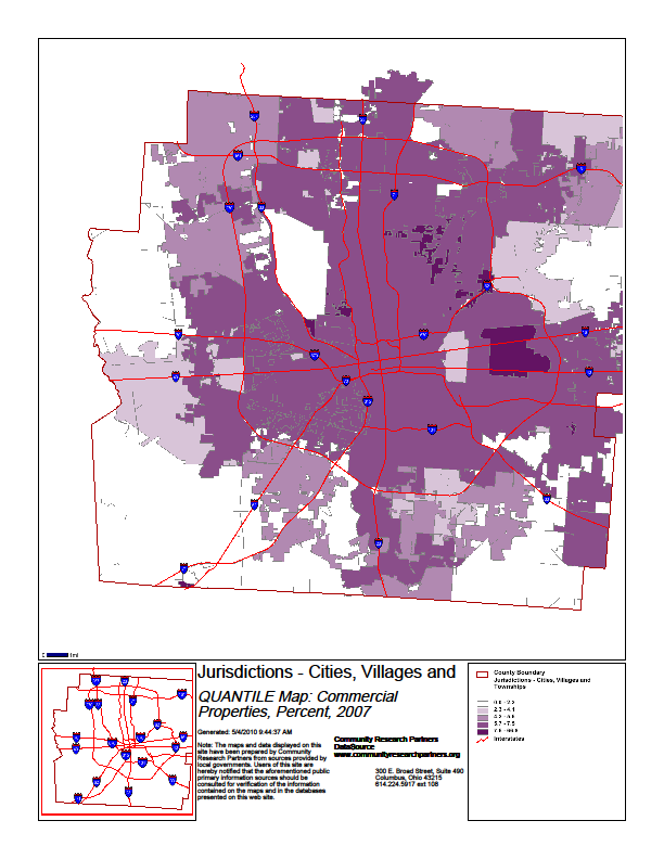
47 Land Use Categories of land use by percentages: residential, commercial, industrial, government. 46
48 47
49 48

50 49

51 Transportation The county has interstate highway miles, U.S. highway miles, state highway miles and 4, county, township and municipal road miles. Franklin County is bisected by two major interstate highways, Interstate 70 running eastwest, and Interstate 71 running north to southwest. The two highways run together for 1.5 miles through the city, creating a major traffic congestion point. The Interstate 270 Outerbelt encircles the vast majority of the city, providing traffic flow to and from suburban communities and surrounding counties. The Interstate 670 spur on the north side of the city continues to the east past the airport and west to a merger with I-70. These highways are commuting routes for people in surrounding counties. In 2000, 101,256 commuters traveled into Franklin County from Delaware, Madison, Licking, Fairfield and Pickaway Counties. Due to its central location within the state, the abundance of outbound roadways makes nearly all of the state s destinations within a 2-hour drive. The county is also within 550 miles of half the U.S. population, making it a major transportation hub. Map source: experiencecolumbus.org In addition to commuters, Franklin County has the largest daily truck volume of any county in the state. Sixty-six per cent of the truck traffic passes through the county, to and from external destinations. In addition to Interstates 70 and 71, I-270 has very heavy truck traffic, especially in the Northwest quadrant. This area draws a large number of trucks due to the Buckeye Intermodal Yard and the large volume of warehouses in the area. 50
52 Franklin County is also considered a hub for rail activity in Ohio. The county has two intermodal rail facilities, CSX Buckeye Yard and Norfolk Southern Discovery Park Yard. There are also two classification yards, one at Buckeye Yard and one on Parsons Avenue. These are switching yards and serve the two major railroads plus regional and short-line railroads. The Central Ohio Transit Authority provides bus service for limited routes throughout Franklin County. Commuter points are located in outlying suburbs to encourage the use of bus service to downtown businesses. The county is served by two major airports. Port Columbus, on the east side of the county, provides passenger service and is a hub for NetJets, the world s largest fractional ownership carrier. Rickenbacker, in southern Franklin County, is a major cargo facility and services the Ohio National Guard. Don Scott OSU Airport and Bolton Field are significant general aviation facilities. The county also has several small airstrips and heliports. 51
53 Economy Columbus has historically had strong and diverse economy. In 2006, Business First reported Columbus as having the strongest economy in Ohio and the seventh strongest in the country. It remains to be seen how the economic downturn will affect Columbus and Franklin County in the long term. Franklin County has a large government presence, providing the largest single source of employment in the county, 16% of all workers. This includes the State Capitol as well as city, county and federal facilities and the Ohio State University. One of the largest facilities is the Defense Finance and Accounting Service. Other sources of employment in the county are banking, insurance, research and development, manufacturing and technology. The Mid-Ohio Regional Planning Commission (MORPC) projects the majority of growth in retail and office development will occur in the northern tier of the region, while new industrial warehouse and distribution centers will be located in the southern half of the county near Rickenbacker Airport. The Franklin County Department of Development published the following statistics. 52

54 53

55 Government The Franklin County Board of Commissioners serves as the administrative head of Franklin County Government. The three-member board manages county funds, oversees more than 130 county-owned buildings and serves as the county s sole contracting and taxing authority. The following is the organization of county government. Franklin County is currently made up of 12 cities, 12 villages and 17 townships. Cities Bexley Grove City Worthington Columbus Hilliard Whitehall Dublin Reynoldsburg Gahanna Upper Arlington Grandview Heights Westerville 54
56 Villages Brice Canal Winchester Groveport Harrisburg Lockbourne Marble Cliff Minerva Part New Albany Obetz Riverlea Urbancrest Valleyview Townships Blendon Jefferson Pleasant Brown Madison Prairie Clinton Mifflin Sharon Franklin Norwich Truro Hamilton Perry Washington Jackson Plain Franklin County Cities, Villages, Townships Source: Ohio County Profiles - ODOD 55
57 Critical Facilities The following is a generic list of critical facilities in Franklin County. For security purposes specific addresses and descriptions are not included. While not all inclusive, the list illustrates the multitude of critical sites that could be affected in a disaster. Emergency Response Facilities Hospitals/Medical Clinics Communications/Emergency Operations Centers Other Direction and Control Operations Centers Essential Government Buildings Fire Departments/EMS Services Law Enforcement/Sheriff, Police Jails/Correction Centers Emergency Shelters Disaster Recovery Centers/Disaster Field Offices Public Health Departments Public Services and Utilities Emergency Alert System Stations and Towers: Radio, Television and Cable Other Radio and Television Stations and Towers Government Communications Towers and Repeaters Telephone System Distribution Points and Towers: Land Line, Cellular, Microwave Sewage Treatment and Plants Potable Water Distribution Systems, Treatment Plants, and Lift Stations Electrical Power Generating Plants and Electrical Substations Major Electrical Distribution Systems/Routes Essential Public Service Offices Vital Private/Commercial Facilities Private Potable Water Treatment and Distribution Systems Private Sewage Treatment and Waste Systems Commercial Distribution Centers Building/Construction Materials Potable Water and Ice Suppliers Food Retailers Power Generators Suppliers of Fuels (Gasoline, Diesel, Propane, Natural Gas, etc.) Suppliers of Light Equipment (Chain Saws, Shovels, Barricades, etc.) Suppliers of Heavy Equipment (Bulldozers, Forklifts, etc.) Medical Supply Companies Food Processing Plants Restaurants/Cafeterias Community Centers/Auditoriums 56
58 Vital Private/Commercial Facilities (cont) Major Fuel Pipelines and Terminals Fuel Storage and Tank Farms Transportation Facilities Airports/Heliports Response Operations Staging Areas Critical Transportation Routes High Risk Intersections/Critical Links/Bridges Railroad Stations Other Facilities Churches/Synagogues Fellowship and Recreation Halls Colleges/Universities Public and Private Schools Motels/Hotels Nursing/Convalescent/Group Homes Animal Care/Animal Shelters Hazardous Materials Facilities Flood Control Stations and Devices 57
59 Major Events There are several locations and facilities in Franklin County that are venues for many major festivals and events. As large congregate areas, these sites are of major consideration in emergency planning. Downtown Columbus is the site of several events that draw huge crowds in the midst of the major State government center, as well as city, county and federal government facilities. These events include: Red, White and Boom; Columbus Arts Festival; Columbus Jazz and Ribs Festival and several others. Some of these events draw as many as 500,000 people to the center of Columbus. Downtown Columbus is also the site of the Columbus Convention Center, Nationwide Arena, Veterans Memorial Auditorium and several theaters which host large crowds regularly. In addition to the events in Columbus, several suburban communities also hold annual large-scale events, including the Dublin Irish Festival, the Tomato Festival in Reynoldsburg, and the Franklin County Fair in Hilliard. Franklin County hosts a number of sporting events throughout the year. Ohio Stadium, with a capacity of over 100,000, is home to the Ohio State Buckeye football games. The Columbus Crew professional soccer team facility and the Ohio Expo Center are located along I-71 north of downtown Columbus. The Schottenstein Center on the Ohio State University Campus and Nationwide Arena in Columbus host sporting events, family shows and touring productions throughout the year. 58
60 Franklin County Profile References Central Ohio Indicators (2008) Central Ohio Data Access Tools Franklin County Emergency Management and Homeland Security (2003) Natural Hazards Mitigation Plan Community Profile Franklin County Emergency Management and Homeland Security (2006) Franklin County Basic Emergency Operations Plan Franklin County Government Website Mid Ohio Regional Planning Commission. Demographic Fact Sheet for Franklin County Mid Ohio Regional Planning Commission (2004) Central Ohio Freight Fact Book Rail Operations - Central Ohio Mid Ohio Regional Planning Commission. Truck Freight Overview Central Ohio Office of Policy, Research and Strategic Planning, Ohio Department of Development (2007) Ohio County Profiles Franklin County Ohio History Central Ohio Historical Society. Franklin County [Online] 19 Feb Ohio State University. The OSU Extension Fact Sheet: Water Resources of Franklin County [Online] 23 Feb U.S. Census Bureau. Franklin County Ohio [Online] 26 Feb
61 Section 3 Hazard Identification Contents Section 3 Hazard Identification Hazard Identification Hazard Relationships Types of Hazards Ohio Hazards Disasters and Declarations Hazard Identification References
62 Hazard Identification A hazard is a source of harm to a community, including its population, environment, private and public property, infrastructure and businesses. In the days of Civil Defense, hazards were thought of in two categories: natural hazards and enemy attack. Later, as hazardous materials began to be a problem, technological hazards were added as a category. Since the end of the Cold War, hazards have been classified into three groups: natural, technological, and human-caused. NFPA 1600 A describes the following types of hazards: Naturally occurring hazards that can occur without influence of people and have potential direct or indirect impact on the entity (people, property, the environment). Human-caused events, accidental or intentional. Technological-caused events that can be unrelated to natural or human-caused events. Hazards in one category may cause a secondary hazard or disaster in the same or another category that increases the impact. Some examples: A hurricane may produce tornadoes. A major flood may cause a dam to break. A highway accident may lead to a hazardous materials spill. A train derailment may produce a wildfire. Excessive flooding may result in infectious disease. A bombing may lead to a fire. Computer sabotage may lead to a power failure. A terrorist attack may spread deadly disease. Almost any combination of hazards is possible. The relationships between many types of hazards may become complex. One or more secondary, tertiary, or even further events may occur. The following table illustrates these relationships. The table also shows that an event may be either a primary or secondary event depending on circumstances. 61
63 Secondary Events Aircraft Accident Animals-Loss/injured/dead Crop Damage Dam/Dike Failure Epidemic Explosion Fallout Fire Flash Flood Food Shortage Fuel Shortage Hazardous Materials Incident Housing Shortage Human Injured/Dead Industrial Accident Power/Gas Failure Radiological Incident Structural Collapse Train Derailment Vehicular Wreck Water Shortage Risk Assessment For Hazard Relationships Primary Event Natural Flood River X X X X X X X X X X X X X X Creeks X X X X X X X X X X X X X X Flash X X X X X X X X X X X X X X Tornadoes X X X X X X X X X X X X X X X X Storms Lightning X X X X X X X X X Hail X X X X X X X Wind X X X X X X X X X X X Blizzard Heavy Snow X X X X X X X X X X X X X X X X X Ice X X X X X X X X X X X X Drought X X X X X X Earthquake X X X X X X X X X X X X X X Fog X X X X X Infectious Disease X X X Human-caused Hazardous Materials Transportation Vehicular Wreck X X X X X X X X Train Derailment X X X X X Downed Aircraft X X X X X Industrial Explosion X X X X X X X X X Fire X X X X X X X X Accidental Release X X X X X X Theft/Loss X X Nuclear Emergencies X X X X X X X X X X X X X X X X X X X Infectious Disease X X X Fire High Rise X X X Multiple Buildings X X X X X 62
64 Secondary Events Aircraft Accident Animals-Loss/injured/dead Crop Damage Dam/Dike Failure Epidemic Explosion Fallout Fire Flash Flood Food Shortage Fuel Shortage Hazardous Materials Incident Housing Shortage Human Injured/Dead Industrial Accident Power/Gas Failure Radiological Incident Structural Collapse Train Derailment Vehicular Wreck Water Shortage Risk Assessment For Primary Event Fire (cont) Industrial X X X X X X X X Gas Lines X X X X X X Chemical Plant X X X X X X X Health Care Facility X X X X X Explosion Pipelines X X X X X X X X X Industrial X X X X X X X X X Chemical X X X X X Dam Failure X X X X X X X X X X X X Transportation Accidents Highway X X X X X X X X X X Rail X X X X X X X X X Air X X X X X X X Civil Disturbance Riot X X X X X X X Bomb Threat X X X X X X X X X Terrorism/Sabotage X X X X X X X X X X X X X X X X X X X X X Technological-Caused Computer Related X X X X X X X X Telecommunications X X X X Utility Power/Light X X X X Natural Gas X X X X X X Water System Water Plant X X X Water Mains X Storm Drainage Sanitary Drainage Disposal Plant X X X Mains X X Lift Stations X X Adapted from Sedgwick, Kansas Hazard Analysis
65 Types of Hazards Natural Hazards Natural hazards are an ever present risk to life and property throughout the United States. Often, natural hazards can be predicted. They tend to occur repeatedly in the same geographical locations because they are related to weather patterns or physical characteristics of an area. Natural hazards can be classified into three groups: Geological Hazards related to the geographical characteristics or natural earth processes of the area, e.g. earthquakes, volcano, landslides. Meteorological Hazards natural processes or phenomena of an atmospheric, hydrological or oceanographic nature, including weather patterns of the area, e.g. floods, tornadoes, winter storms. Biological Hazards processes of organic origin or those conveyed by biological vectors, including exposure to pathogenic microorganisms, toxins and bioactive substances; these include epidemics and insect infestations. May be intentionally caused. Human-caused Events Human-caused events are divided into two groups: accidental and intentional. Accidental human-caused events include hazardous material spills, transportation accidents, air/water pollution and dam failure. Intentional human-caused events include civil disturbances, criminal activity and terrorism. Technological Hazards Technological hazards are events that can be unrelated to natural or human-caused events, such as central computer, mainframe, software or application failure; telecommunication system failure; and energy, power or utility failure. 64
66 Ohio Hazards There is a wide range of hazards and disasters to consider when preparing a risk assessment for a specific area. Many hazards are large and obvious; however, there are many everyday emergency situations at the local level that need attention. Ohio EMA reviewed the hazard analysis literature and identified nearly sixty hazards. These hazards include those listed in NFPA 1600, the 15 National Planning Scenarios, the National Plan Review and Ohio EMA s Enhanced Mitigation Plan. These hazards are listed in the following table. Those not considered by OEMA as Ohio hazards are not considered as hazards for Franklin County. Some Ohio hazards are not germane to Franklin County and not likely enough a scenario to warrant consideration. Those that are identified for Franklin County are included in this risk assessment. 65
67 Hazards Identified in OEMA s Hazard Identification and Risk Analysis: Update 2007 Natural Hazards/Events Biological Animal or Insect Infestation or Damage Emerging Disease Geological Earthquake Landslide, Mudslide, Subsidence Meteorological Drought Extreme Temperatures Fire Flood, Flash Flood, Seiche Lightning Strikes Snow, Ice, Hail, Sleet Windstorm, Tornado Technological Hazards/Events Central Computer, Mainframe, Software or Application Failure Energy/Power/Utility Telecommunications Human Caused Events Accidental Air/Water Pollution, Contamination Building/Structure Collapse Communications System Interruptions Energy/Power/Utility Failure Explosion/Fire Fuel/Resource Shortage Hazardous Material Transportation Accident Water Control Structure Intentional Civil Disturbance, Public Unrest, Mass Hysteria Criminal Activity Product Defect Terrorism Not Analyzed for OEMA HIRA Ancillary Support Equipment Failure (support and lab-based equipment) Avalanche Discrimination Disinformation (deliberate) Dust Storm Electromagnetic Pulse (intensely fluctuating magnetic field) Enemy Attack/War Famine Financial Issues (Economic Depression, Inflation, Financial System Collapse) Geomagnetic Storm (temporary disturbance of atmosphere, causing communications disruption, among other things) Glacier Harassment Hurricane Iceberg Insurrection (revolt) Misinformation (non-deliberate) Sabotage Sand Storm Strike or Labor Dispute Tidal Surge Tropical Cyclone Tsunami Water Spout Workplace Violence Volcano 66

68 Disasters and Declarations 67
69 The following table illustrates Presidential Declarations by FEMA Region from January 10, 2000 to January 8,
70 Franklin County Declarations March 24, 1964 June 5, 1968 April 4, 1974 January 26, 1978 June 10, 1989 June 6, 1990 August 4, 1992 June 30, 1998 November 18, 2002 March 24, 2003 August 1, 2003 January 26, 2004 January 11, 2005 February 15, 2005 September 13, 2005 September 2008 Heavy rains and flooding Heavy rains and flooding Tornadoes and high winds Severe blizzard Severe storms and flooding Severe storms, tornadoes, and flooding Severe storms, tornadoes, and flooding Flash flooding, flooding, high winds and tornadoes Tornadoes, severe storms Ice/snow storm Severe storms, tornadoes and flooding Severe storms and landslides Snow removal and response Severe winter storms, ice and mudslides Hurricane Katrina Emergency Shelter Operations Hurricane Ike, severe wind damage Source: Ohio Emergency Management Agency Declarations were for multiple events in multiple counties in the state. 69
71 NOAA s National Climatic Data Center reported the following meteorological hazards for Franklin County from January 1, 1950 to March 31,
72 Hazard Identification References Absolute Astronomy. Disaster. [Online] 5 Mar FEMA, State and Local Mitigation Planning, how-to Guide: Hazard Identification, Version 1.0. August 2001 Franklin County Emergency Management and Homeland Security, Hazard Analysis for Franklin County Franklin County Emergency Management and Homeland Security, Natural Hazards Mitigation Plan General Accounting Office. Natural Hazard Mitigation. [Online] 5 Mar National Fire Prevention Association. NFPA , Section 5.3 NOAA, NWS, General Hazard Information OEMA, Hazard Identification and Risk Assessment OEMA, State of Ohio Mitigation Plan Quarantelli, E.L., Catastrophes Are Different from Disasters: Some Implications for Crisis Planning and Managing, Drawn from Katrina. Disaster Research Center, University of Delaware. 11 June 2006 Tulane University, Natural Disasters and Assessing Hazards and Risks. Updated 26 Aug
73 Section 4 Franklin County Hazards Contents Tornadoes - # Dam Failure - # Flooding - # WMD Terrorist Incident - # Cyber-Terrorism - # Infectious Diseases - # Severe Winter Weather: Snow, Ice, Extreme Cold - # Hazardous Material Incidents - # Transportation Accident Aircraft - # Severe Summer Weather: Thunderstorms, Lightning, Wind and Hail - # Utility/Energy Interruption or Failure - # Civil Disturbance - # Lone Wolf Terrorism- # Air and Water Pollution/Contamination -# Extreme Heat - # Drought - # Invasive Species - # Earthquakes - #
74 Tornadoes - #1 Hazard Summary Tornadoes are nature s most violent windstorms even weak ones can cause significant damage and fatalities. A tornado is defined as a violently rotating column of air, often visible as a funnel cloud, in contact with both the ground and the cloud base. Franklin County experienced 26 tornadoes from 1954 through 2008, all of which were rated F3 (or EF3) and under. This hazard was ranked No. 1 out of
75 Hazard Profile According to the Glossary of Meteorology (AMS 2000), a tornado is a violently rotating column of air, pendant from a cumuliform cloud or underneath a cumuliform cloud, and often (but not always) visible as a funnel cloud. In practice, for a vortex to be classified as a tornado, it must be in contact with both the ground and the cloud base. There is some debate, however, as to whether separate touchdowns of the same funnel constitute separate tornadoes, and how close must two or more different tornadic circulations become to qualify as a one multiple-vortex tornado instead of separate tornadoes. A funnel cloud is any rotating cloud pendant from a cumulus or cumulonimbus cloud. A funnel cloud rotates but has no ground contact or debris and creates no damage. A funnel cloud is not associated with strong winds at the surface. Tornadoes often begin as funnel clouds with no associated strong surface winds; however, not all of these funnel clouds evolve into a tornado. Most tornadoes produce strong winds at the surface while the visible funnel is still above ground, so it is difficult to discern the difference between a funnel cloud and a tornado from a distance. Occasionally, a single storm will produce more than one tornado, either simultaneously or in succession. Multiple tornadoes produced by the same storm are referred to as a tornado family. Sometimes, several tornadoes are spawned from the same large-scale storm system. If there is no break in activity, this is considered a tornado outbreak. Unless otherwise noted, all pictures and graphics in this section are from the NOAA National Severe Storms Laboratory 74


76 Tornado Life Cycle Tornadoes often develop from a class of thunderstorms known as supercells. Supercells contain a mesocyclone, an area of organized rotation a few miles up in the atmosphere, usually 1 to 6 miles across. The most destructive and deadly tornadoes occur from supercells. Supercells can also produce damaging hail, severe non-tornadic winds, lightning and flash floods. Source: NOAA 75
77 Thunderstorms develop in warm, moist air in advance of eastward-moving cold fronts. These thunderstorms often produce large hail, strong winds, and tornadoes. Initially, the tornado has a good source of warm, moist inflow to power it, so it grows until it reaches the mature stage. This can last anywhere from a few minutes to more than an hour, and it is during that time that a tornado often causes the most damage. As the tornado enters the dissipating stage, its associated mesocyclone often weakens as well. Even though the tornado is dissipating, it is still capable of causing damage. The storm is contracting into a rope-like tube, and like an ice skater who pulls her arms in to spin faster, winds can increase at this point. Types of Tornadoes Multiple Vortex Tornadoes Multiple vortex tornadoes contain two or more small, intense columns of spinning air orbiting the center of the larger tornado circulation. These vortices may form and die within a few seconds, sometimes appearing to train through the same part of the tornado one after another. They can happen in all sorts of tornado sizes. These vortices often create small areas of heavier damage along the main tornado path. Satellite Tornadoes A satellite tornado develops independently from the primary tornado, not inside it. The tornadoes remain separate and distinct as the satellite tornado orbits its much larger companion within the same mesocyclone. Their cause is unknown but they seem to form most often in the vicinity of exceptionally large and intense tornadoes. Source: NOAA Waterspouts A water spout is simply a tornado over water. They are common along the southeast U.S. coast, especially off southern Florida and the Keys. They can happen over seas, bays, and lakes worldwide. They are smaller and weaker than the most intense Great Plains 76
78 tornadoes but can still be dangerous. They can overturn boats, damage larger ships, and do significant damage when they hit land. Landspout A landspout is officially known as a dust-tube tornado and is not associated with a mesocyclone. They are essentially a fair weather waterspout on land. Landspouts are relatively weak, short lived, small, smooth condensation funnels, which often do not touch the ground. Although usually weaker than classic tornadoes, they will produce strong winds and may cause serious damage. Tornado-like Circulations A gustnado or gust front tornado is a small, vertical swirl associated with a gust front or downburst. Because they are not associated with the cloud base, there is some question as to whether or not gustnadoes are actually tornadoes. They are Source: NOAA formed when fast moving cold, dry outflow air from a thunderstorm is blown through a mass of stationary, warm, moist air near the outflow boundary, resulting in a rolling effect (often exemplified through a roll cloud). If the low level wind shear is strong enough, the rotation can be turned horizontally or diagonally and make contact with the ground. The result is a gustnado. They usually cause small areas of heavier rotational wind damage among areas of straight-line wind damage. A dust devil resembles a tornado in that it is a vertical swirling column of air. However, they form under clear skies and are rarely as strong as even the weakest tornado. They form when a strong convective updraft is formed near the ground on a hot day. They can occasionally result in major damage, especially in arid areas. Fire whirls are tornado-like circulations occasionally occurring near large, intense wildfires. They are not considered tornadoes and are not as strong. However, they can produce significant damage. A steam devil is a rotating updraft that involves steam or smoke. A steam devil is very rare, but they mainly form from smoke emitting from a power plant smoke stack. There have also been reports of cold air steam devils as well. 77
79 Tornado Characteristics Shape Most tornadoes take on the appearance of a narrow funnel, a few hundred yards across, with a small cloud of debris near the ground. However, tornadoes can appear in many shapes and sizes. Large single vortex tornadoes can look like a large wedge stuck into the ground, and so are known as wedge tornadoes. Wedge tornadoes appear to be at least as wide as they are tall from ground to ambient cloud base. A wedge can be so wide that it appears to be a block of dark clouds, making it difficult to tell the difference between a wedge tornado and a low-hanging cloud. Many but not all major tornadoes are wedges. Source: NOAA Rope tornadoes are very narrow or snake-like. Many tornadoes assume the rope shape in their last stage. Rope tornadoes often curl or twist into complex shapes. Even though they may be in the last stage of the tornado, they can still do violent damage of an EF4 or EF5. Tornado shape and size does not say anything about its strength. Size In the United States, tornadoes average around 500 feet across and stay on the ground for five miles. However, there is an extremely wide range of tornado sizes. Weak tornadoes, or strong dissipating tornadoes, can be exceedingly narrow, sometimes only a few feet across. On the other hand, wedge tornadoes can have a damage path a mile wide or more. Source: NOAA As for path length, many tornadoes which appear to have path lengths of 100 miles or longer are actually a family of tornadoes which have formed in quick succession. One exception, the Tri-State Tornado, which affected parts of Missouri, Illinois, and Indiana on March 18, 1925, was officially on the ground continuously for 219 miles. 78
80 Color Tornadoes can have a wide range of colors, depending on the environment in which they are formed. In a dry environment, a tornado can be nearly invisible, marked only by swirling debris at the base of the funnel. Water spouts can turn very white or even blue. Funnels, which move slowly and pick up a lot of debris, are usually darker, taking on the color of the debris. Tornadoes in the Great Plains can turn red from the reddish tint of the soil. Lighting conditions are also a major factor in the appearance of a tornado. A tornado which is backlit (viewed with the sun behind it) appears very dark. The same tornado, viewed with the sun at the observer s back may appear gray or brilliant white. Tornadoes which occur near sunset can be many different colors, appearing in hues of yellow, orange, and pink. Dust, rain, hail, and the darkness of night can reduce the visibility of tornadoes. Tornadoes occurring in these conditions are especially dangerous as only radar observations or possibly the sound of the tornado can provide any warning to those in the storm s path. Fortunately, most tornadoes form in the rain-free base of the storm where there is little or no rain. Most tornadoes occur in the late afternoon, when the bright sun can illuminate the dark clouds. Sound The most common tornado sound reported is a continuous rumble, like a nearby train. Sometimes a tornado will produce a loud whooshing sound, like a waterfall or open car window. Tornadoes moving through densely populated areas may produce all kinds of noises at once, producing a loud roar. Small tornadoes or funnel clouds may produce whistling, humming or buzzing sounds. Direction and Rotation Tornadoes can appear from any direction. Most move from southwest to northeast or west to east. Some have changed direction mid-path or even backtracked. 79
81 Tornadoes normally rotate cyclonically in one direction (counterclockwise in the northern hemisphere, clockwise in the southern). Climatology The United States has the most tornadoes of any country, about 1,000 yearly. This is mostly due to the unique geography of the continent. (Discussed further in the United States Tornadoes section.) Tornadoes are most common in spring and least common in winter. Since fall and spring are transitional seasons (warm to cool and vice versa), there are more chances of cooler air meeting with warmer air, resulting in thunderstorms. However, favorable conditions can occur any time of the year. Tornadoes have been reported in all months. Most tornadoes occur in the late afternoon, between 3 p.m. and 7 p.m., peaking around 5 p.m.. Tornado Intensity and Damage Tornadoes vary in intensity regardless of shape, size, and location. Typically, strong tornadoes are larger than weak tornadoes. For many years scientists had nothing more than educated guesses as to the speed of the winds in a tornado. The only evidence indicating the wind speeds was in the damage left behind. In 1971, Dr. Tetseya Theodore Fujita introduced the idea for a scale of tornado winds. He introduced what came to be known as the Fujita scale in The scale was supposed to relate the intensity of the wind to the degree of damage. Research conducted in the late 1980s and1990s suggested tornado winds were notoriously overestimated, especially in significant and violent tornadoes. In 2006, the American Meteorological Society introduced the Enhanced Fujita Scale to help assign realistic wind speeds to tornado damage. The scale was designed so that a tornado assessed on the Fujita scale would receive the same ranking on the Enhanced Fujita scale. The EF-scale is more specific in detailing the degrees of damage on different types of structures for a given wind speed. It classifies F0-F5 damage as calibrated by engineers and meteorologists across 28 different types of damage indicators. The Enhanced Fujita scale went into effect in the United States in
 Weak Tornadoes The vast majority of tornadoes are designated F0 or F1, also known as weak tornadoes.")

82 Chart from the NOAA Storm Prediction Center (The 28 indicators noted above can be found at Weak Tornadoes The vast majority of tornadoes are designated F0 or F1, also known as weak tornadoes. However, even weak tornadoes can cause significant damage and fatalities. F0 and F1 tornadoes are typically short lived and stay on the ground for one mile or less. Strong Tornadoes Strong Tornadoes, F2 and F3, are stronger than most tropical cyclones, although cyclones affect a much larger area. An F2 tornado can remove the roof of a well-built structure. And 81
83 F3 damage is a serious risk to life and limb. Few parts of affected buildings are left standing. Wooded areas will suffer almost total loss of vegetation. Violent Tornadoes Violent tornadoes are the F4s and F5s. F4 damage typically results in a total loss of the affected structure. No matter how well built, homes are reduced to a pile of debris. Even heavy vehicles can become airborne and flung some distance. F5 damage is almost always total. F5 tornadoes demolish well-built houses and sweep the foundation clean. Since 1950, only 50 F5 tornadoes have been reported in the United States, and yet these have been responsible for more than 1,000 deaths. In recorded history, F5 tornadoes have performed awesome displays of power, including twisting skyscrapers, leveling entire communities, and stripping asphalt from the ground. 82
84 Source: NOAA 83

85 Tornado Forecasting Until the 1950s, you would never see the word tornado in a weather forecast. Tornado watches and warnings were unheard of because of fear that predicting tornadoes might cause panic. Now, the National Weather Service issues more than 1,000 watches and nearly 30,000 warnings for severe storms and tornadoes each year. The average lead time for warnings increased to 13 minutes by NOAA s Storm Prediction Center (SPC) in Norman, Okla., is responsible for hazardous-weather forecasting across the contiguous United States and supports NWS Forecast Offices by providing shortto-medium range guidance and watch products. Every tornado and severe thunderstorm watch issued in the U.S. originates at the SPC. Watches issued by the SPC are disseminated through local National Weather Service Forecast Offices. National Weather Service Forecast Office issues severe weather forecasts and warnings. Warnings are issued when a severe thunderstorm or tornado is occurring or is imminent. Each NWS office uses output from at least one Doppler radar to help determine if a warning is needed. Doppler radar indicates strong winds blowing toward and away from it in a way that tells forecasters an intense circulation probably exists in the storm, and a tornado is possible. Possible doesn t mean certain, so local forecasters also depend on spotter reports. 84

86 When predicting severe weather (including tornadoes) a day or two in advance, the NWS looks for the development of temperature and wind flow patterns in the atmosphere, which can cause enough moisture, instability, lift, and wind shear for tornadic thunderstorms. Those are the four needed ingredients. A tornado watch means that conditions are favorable for the development of a tornado. Watches are issued by the SPC, usually for four to eight hour periods. A tornado warning means a tornado has been sighted or indicated by weather radar. Warnings are issued by the local NWS Forecast Office. The first public tornado warnings were issued in 1950 and the first tornado watches and convective outlooks in In 1953, it was confirmed that hook echoes are associated with tornadoes. By recognizing these radar signatures, meteorologists could detect thunderstorms that were likely producing tornadoes from dozens of miles away. In the mid 1970s, the NWS increased its efforts to train storm spotters to spot severeweather signs indicating hail, damaging winds and tornadoes, as well as flood damage. When severe weather is anticipated, local weather service offices request these spotters observe and report any tornadoes immediately to assist the offices in issuing a timely warning. Storm spotters are trained to identify supercell storms. The vast majority of intense tornadoes occur within a wall cloud on the backside of a supercell. Only wall clouds that rotate spawn tornadoes, and they usually precede the tornado by five to thirty minutes. Tornadoes may also occur without wall clouds, under flanking lines, and on the leading edge. Spotters watch all areas of a storm, as well as the cloud base and surface. 85
87 Tornadoes in the United States The United States has the most tornadoes of any country. Over the last ten years, an average of 1,200 tornadoes occurred across the continental United States. This is mostly due to the unique geography of the continent. North America is a relatively large continent that extends from the tropical south into arctic areas and has no major east-west mountain range to block air flow between these two areas. Nearly a third of the tornadoes occur in Texas, Oklahoma, Kansas, and Nebraska, an area known as Tornado Alley. In this area during the springtime and early summer, conditions combine for the formation of supercell thunderstorms and tornadoes. Over 55% of a year s tornadoes occur between the months of April and June, when cool, dry air from Canada clashes with warm, moist air from the Gulf of Mexico. The most tornadoes in one year occurred in 2004, when 1,819 tornadoes were reported. The deadliest tornado in the United States was the Tri-state tornado of March 18, It killed 695 people as it raced along at mph in a 219 mile long track across parts of Missouri, Illinois and Indiana. This tornado also holds the record for the most tornado fatalities in a single city; at least 234 people died in Murphysboro, Illinois. The largest tornado outbreak occurred on April 3 and 4, This tornado outbreak, known as the Super Outbreak, produced 148 tornadoes in less than 24 hours from Michigan to Alabama. Ohio was one of the hardest hit states. The Super Outbreak is discussed in more detail in the Ohio Tornado History section of this document. One of the largest known tornados is the Hallam, Nebraska, F4 tornado of May 22, It is the record holder for width at 2.5 miles. The Tri-state tornado holds the record for longest path, 219 miles. The strongest tornado wind speed ever recorded was 318 mph at Bridge Creek, Oklahoma. However, ground speeds of the most violent tornadoes have never been directly measured because they destroyed weather instruments. Tornadoes routinely cause millions of dollars in property damage; the 10 costliest tornadoes alone have caused nearly $6 billion in damage. The costliest tornado outbreak occurred in 1999 in Oklahoma. From May 3 to May 6, more than 66 tornadoes tore through the state. The largest one destroyed more than 10,500 buildings, killed 42 people, and caused $1.1 billion in damages. This is the tornado mentioned above that struck Bridge Creek, Oklahoma. American tornadoes are still killers, but they cause significantly fewer deaths today than in the previous century. The last tornado to kill more than 100 people happened over 50 years ago in Flint, Michigan. Forecast and warning systems have improved over the years, and with increased awareness and education have saved lives. 86
88 87


89 Tornadoes in Ohio Ohio is no stranger to tornadoes. Located on the eastern edge of Tornado Alley, Ohio averages 16 tornadoes a year. The peak tornado season for Ohio is April through July. June has the most tornado occurrences, but many of the state s major tornado outbreaks have taken place in April and May. Most tornadoes occurred between 2 and 10 p.m. However, history has proven that tornadoes can occur during any month of the year at any time of the day or night. Significant Tornado Events in Ohio May 14, 1886 was a deadly month in Ohio weather. Floods killed 28 people at Xenia on May 12, and two days later, on May 14, Ohio s deadliest tornado outbreak of the 19 th century occurred. Three separate tornadoes cut a path 110 miles long, killing 17 people, in Mercer, Wyandot and Seneca counties. Notice the headline from the Cleveland Plain Dealer. The storm was called a cyclone, not a tornado. At that time the word tornado was not used for fear of causing panic. March 28, 1920 was the first of two Palm Sunday tornado outbreaks to hit Ohio. This outbreak of 30 tornadoes across eight states killed 153 people. Four killer tornadoes moved into western Ohio from Indiana and another moved across Wood and Ottawa Counties. There were 29 deaths in Ohio from these tornadoes. June 28, 1924, the deadliest tornado in Ohio history struck Lorain and Sandusky. It struck an urban area where 85 people were killed, 72 in Lorain. Buildings were damaged for 35 blocks along Broadway and at least 200 automobiles were buried in bricks and rubble. More than 1,000 homes were damaged and 500 destroyed in Lorain. The death toll of 15 in the State Theater is the most ever killed by a tornado in one building in Ohio. 88
90 April 11, 1965 was the second Palm Sunday tornado outbreak. Thirty-seven tornadoes killed 256 people, mostly in Ohio, Michigan, and Indiana. The 55 people killed in Ohio made this the second deadliest tornado day in Ohio history, after the 1924 Lorain tornado. Nineteen tornadoes in this outbreak were of F4 or F5 intensity, with the strongest tornadoes occurring in Elkhart, Indiana and Strongsville, Ohio. Damage estimates were over $200 million for the event. April 3-4, 1974 the most intense and widespread tornado outbreak in recorded history occurred. Known as the Super Outbreak, a total of 148 tornadoes spanned 13 states, producing about 900 square miles of tornado damage in less than 18 hours. This tornado outbreak represented a rare occurrence. Several factors came together at the right time to allow for the magnitude of the outbreak. These factors include: (1) the location and energy of the upper level wave (disturbance) with respect to the surface low pressure region; (2) the relatively warm Gulf region providing an abundance of warm, moist surface air; (3) the extent of the upper level dry air and the resulting subsidence (lid effect); and (4) the extent of the solar heating. Take away one or more of these factors and the enormity of the outbreak would likely have been greatly reduced. Speculation is that it might be several hundred years before such a confluence of factors occurs again. The most deadly tornado in the entire Super Outbreak devastated Xenia (pop 25,000) in Greene County, Ohio, shortly after 3:30 p.m. Thirty-four people were killed and more than 1,600 injured. The F5 tornado destroyed around 1,300 buildings and damaged 2,000 others, causing losses of over $130 million. The Xenia tornado was rated an F5. It was one of two F5s that affected Ohio during the outbreak, the other struck the Cincinnati area and was known as the Sayler Park tornado. 89
91 In Ohio, 12 tornadoes touched down, killing 36 people. The last tornado in the outbreak touched down in Franklin County, just west of New Albany (number 39 on the map). This tornado destroyed one home and three barns and damaged 20 houses along a 25 mile path. Twenty-six years later, on September 20, 2000, Xenia was hit again. This time an F4 tornado struck at an unusual time, in autumn after dark. This tornado cut a path roughly parallel to and just north of the 1974 tornado, killing one, injuring nearly 100, and damaging over 300 homes. Some homes damaged or destroyed in the 1974 tornado were hit again. Xenia, named after the Greek word for hospitality, has a long history of severe storms going back to the early 1800s. Local records show 20 tornadoes in Greene County since It is said that before the area now known as Xenia was settled, the Shawnee tribe who lived close by referred to the area as the Land of Devil Winds and refused to settle there. 90

92 The 1974 Super Outbreak was especially significant for several reasons. Prior to the 1974 Super Outbreak, researchers were unable to characterize the intensity distribution within a tornado s path. Fujita s extensive aerial survey after the outbreak provided the necessary data to develop an empirical relationship for the width of each F-scale damage area within a tornado path. This survey data provided a new means for assessing tornado intensity probabilities that accounted for the gradation of damage within the tornado path. To this day, this relationship remains the basis for estimating the intensity distribution within tornadoes. (RMS special report) Research from the 1974 event also provided further evidence of intense vortices embedded inside a tornado and led to the discovery of downbursts (small scale damaging downdrafts) that were recognized as the cause of several major airline accidents in the following decade. In addition to the scientific advances, the outbreak also led to NOAA s rapid expansion of its weather radio network. During the 1974 event, tornado warnings were being posted so frequently, they could not be transmitted from the NWS offices fast enough using teletype. Commercial radio stations also had difficulty re-transmitting the information. After the outbreak, NOAA initiated an immediate expansion of its weather radio network across the country, along with a modernization program that allowed the National Weather Service to adopt new technology, improving weather warning lead-times and accuracy. There have also been great advances in weather radar capabilities since At that time, NWS forecasters could see only green blobs on their radar scopes and relied on visual confirmation to issue tornado warnings. The NWS depended on 1950s and 1970s vintage radar technology to operate a combination of network and local warning radars to monitor weather systems. They were obsolete and difficult to service, and large areas were not served by any NWS radar. After a $4.5 billion modernization program and explosive growth in technology, today s NWS has significantly advanced its warning capabilities. NWS forecasters now warn of severe weather events threatening life and property using Doppler Weather Source: NWS Wilmington OH Surveillance Radars. Doppler radar observes the presence and calculates the speed and direction of severe weather elements such as tornadoes and thunderstorms. They also provide quantitative area precipitation measurements, important in hydrologic forecasting of potential flooding. The severe weather and motion detection capabilities offered by radars contribute toward an increase in the accuracy and timeliness of NWS warning services. (NOAA and the 1974 Tornado Outbreak Radar Technology Then and Now) 91
93 May 31, 1985, 14 killer tornadoes struck northeastern Ohio, western Pennsylvania, and southern Ontario. With 11 dead in Trumbull County, Ohio, this was Ohio s deadliest tornado outbreak since the Xenia Tornado of The most famous Ohio tornado of this outbreak touched down in Portage County and cut a 47 mile path through Newton Falls, Niles, and Hubbard before entering Pennsylvania. This was the only F5 tornado in the United States in July 12, 1992, 28 tornadoes occurred in Ohio, the most recorded in a single day. They also contributed to the July 1992 record of 44 tornadoes in one month and a record annual total of 61 tornadoes. Fortunately, summer tornadoes tend to be weaker than spring storms and none of the 44 tornadoes were violent. There were no fatalities and only 36 injuries from this record number of tornadoes. April 9, 1999, a tornado struck the Cincinnati area in the early morning hours. It killed four people in the Blue Ash and Montgomery area. The storm was classified as an F4. Two fatalities were in vehicles and two others in homes. The storm was a quarter mile wide and destroyed 91 homes and apartments and 37 businesses in Hamilton County. Another 674 homes and apartments and 44 businesses were damaged. Several homes, garages and barns were damaged in Warren County. November 10, 2002, an F4 tornado moved through Van Wert, Ohio, destroying the entire northwest corner of the city. This tornado was part of a large outbreak of 70 tornadoes occurring over two days. Four people died and 26 were injured. The storm caused $490 million in damages. The manager of a Van Wert movie theater received a tornado warning through a system directly tied to the Van Wert County siren system. He and his staff got more than 50 people to safety in hallways and restrooms. The theater was destroyed. The county had just become a Storm Ready county on January 22, 2002, which was credited with saving many lives. 92

94 Tornadoes in Franklin County The National Weather Service National Climatic Data Center reported 26 tornadoes in Franklin County from 1954 through There were five tornadoes reported in 1973, the most of any year, followed by 2006 with three tornadoes. 93

95 Map of Franklin County Tornadoes, The Tornado History Project (Note: The tornadoes are scattered throughout the entire county.) The strongest tornadoes reported in the county were F3s. One on February 22, 1971, moved northeast across the east side of Columbus, near Port Columbus through Gahanna. The path of this tornado was 7 miles long and 100 yards wide. Seven people were injured and $2.5M in damage was reported. Below is a map of the path of this tornado. May 8, 1971 tornado, The Tornado History Project 94

96 The other F3 tornado to touch down in Franklin County was two years later on May 10, This tornado entered the county north of Hilliard and moved through the northern suburbs of Columbus, Gahanna and Pataskala, lifting up on the Licking/Perry County line east of Buckeye Lake. This tornado appeared to skip throughout its path. The tornado was 300 yards wide and traveled 90 miles through five counties. Eight people were injured and damage was reported at $5K (map below). Note the direction of tornado path, northwest to southeast. May 10, 1973 Tornado, The Tornado History Project Six F2 tornadoes have been reported in Franklin County. One F2 tornado, on October 11, 2006, was one of the most expensive in damages. The tornado touched down and moved through the Upper Albany West subdivision one mile northwest of New Albany. Sixtyseven homes were damaged, sixteen of them severely, and an additional eight were destroyed. Many homes sustained significant roof, siding and window damage. Property damage was estimated a $50M. 95


97 Franklin County Outdoor Warning System At 172 sirens, Franklin County has one of the largest siren systems in Ohio. The system is complemented by 24 sirens operated by the City of Dublin, the yellow sirens on the map below. The siren system is an outdoor warning system; the sirens are not intended to be heard indoors. The sirens are activated when the National Weather Service issues a tornado warning when a tornado is occurring or imminent in Franklin County. Citizens are also strongly encouraged to purchase and use a Weather Alert Radio for reliable tornado watch and warning notifications when they are indoors. 96
98 Tornadoes References Analysis and Reconstruction of the 1994 Tornado Super Outbreak, Risk Management Solutions Special Report, 2004 Boruff, B.J, Easoz, J.A., Jones, D.D., Landry, H.R., Mitchem, J.D., Cutter, S. L., Tornado Hazards in the United States. Climate Research 24: , 2003 Federal Emergency Management Agency, Ohio Disaster History. [Online] 7 April Franklin County Emergency Management and Homeland Security, Hazard Analysis for Franklin County 1996 Franklin County Emergency Management and Homeland Security, What You Need to Know About Tornadoes NCDC NOAA, Query Results, Tornadoes, Franklin County, Ohio. [Online] 10 Apr NOAA, Advanced Spotters Field Guide NOAA PA NOAA Basic Spotters Field Guide NOAA PA NOAA, Enhanced F Scale for Tornado Damage. [Online] 19 Mar NOAA, Forecasting Tornadoes, [Online] 24 Mar NOAA, Radar Technology Then and Now, [Online] 7 Apr NOAA, The Widespread Tornado Outbreak of April 3-4, 1974, [Online] NSSL NOAA, Tornadoes: Natures Most Violent Storms. USDC, NOAA-NWS, Sept 1992 NWS Norman Oklahoma, Forecasting Tornadoes Today. [Online] 24 Mar NWS Wilmington Ohio, Franklin County Ohio Tornadoes. [Online] 97
99 Ohio Committee for Severe Weather Awareness, When Seconds Count Storm Ready Communities Are Prepared. [Online] 9 Apr OEMA, Hazard Identification and Risk Assessment, 2007 OEMA, State of Ohio Mitigation Plan, 2008 Ohio Insurance Institute, Tornadoes in Ohio and U.S. [Online] 7 Apr Ohio Historical Society, Ohio History Central, Numerous articles on specific tornado events in Ohio. Storm Prediction Center NOAA, The Online Tornado FAQ. [Online] 19 Mar Tornado History Project, Franklin County Query. [Online] 10 Apr Tornado Newspaper Archive, American Tornado History. [Online] 6 Apr
100 Dam Failure - #2 Hazard Summary Dam failure is defined as a catastrophic mishap characterized by the sudden, rapid, and uncontrolled release of impounded water. Dam failure can occur with little or no warning and for one or a combination of reasons, including overtopping, seepage (water percolating through the dam and its foundation) and structural failure caused by earthquakes, sliding and slope instability, or faulty construction. Two dams serving Franklin County are on the Ohio EMA s list of the ten most potentially hazardous dams in the state, based on the possible catastrophic consequences should they fail. This hazard was ranked No. 2 out of
101 Hazard Profile A dam is an artificial barrier usually constructed across a stream channel to impound water. The materials used for construction of dams include earth, rock, tailings from mining or milling, concrete, masonry, steel, timber, and any combination of these materials. Dams provide flood control, water supply for drinking, irrigation for farming, recreational areas and clean, renewable energy through hydropower. Many dams fulfill a combination of the above functions. There are different types of dams classified by the material and design used in construction. Embankment dams are the most common type of dam in use today. Materials used for embankment dams include natural soil or rock, or waste materials obtained from mining or milling operations. An embankment dam is also referred to as an earthfill or rockfill dam, depending on whether it is comprised of compacted earth or mostly compacted or dumped rock. The ability of an embankment dam to resist the reservoir water pressure is primarily a result of the mass weight, type and strength of the materials from which the dam is made. Concrete dams may be categorized into gravity and arch dams according to the designs used to resist the stress due to reservoir pressure. Concrete gravity dams are the most common form of concrete dam. The mass weight of concrete and friction resist the reservoir water pressure. A buttress dam is a specific type of gravity dam in which the large mass of concrete is reduced and the forces are diverted to the dam foundation through vertical or sloping buttresses. Gravity dams are constructed of vertical blocks of concrete with flexible seals in the joints between the blocks. Concrete arch dams are rather thin in cross-section. The reservoir water forces acting on an arch dam are carried laterally into the abutments. Why Dams Fail The Federal Emergency Management Agency defines dam failure as a catastrophic type of failure characterized by the sudden, rapid, and uncontrolled release of impounded water or the likelihood of such an uncontrolled release. Dam failure can occur with little warning and for one or a combination of several reasons: Overtopping accounts for 34% of all dam failures nationally. Overtopping failures result from the erosive action of water on the embankment. Erosion is due to uncontrolled flow of water over, around and adjacent to the dam. Once erosion has begun during overtopping, it is almost impossible to stop. Overtopping is caused by inadequate spillway design, debris blockage of spillway or settlement of dam crest. Seepage accounts for 20% of all dam failures nationally. Seepage failures are caused by uncontrolled seepage from water percolating slowly through the dam and its foundation. Progressively eroding the soil from the embankment or its foundation can result in rapid failure of the dam. The erosion starts on the downstream side of the embankment, eventually develops a pipe, and if fully 100
102 developed is impossible to control and will likely cause failure. Seepage and erosion can occur along hydraulic structures such as outlet conduits or spillways. Structural failure accounts for 30% of all dam failures nationally. Structural failures can occur either in the embankment or the appurtenances such as spillways or lake drains. Cracking, settlement, and slides are the more common signs of structural failure and usually require emergency measures to ensure safety. Structural failures can be caused by earthquakes, sliding and slope instability, or faulty construction. These types of dam failures are often interrelated. For example, uncontrolled seepage may weaken the soil and lead to structural failure. Dam Classification The classification of dams in Ohio is defined in the Ohio Administrative Code. This classification covers dams under the control of the Ohio Department of Natural Resources, Division of Water. The classification system for dams in Ohio was modeled after the Federal Guidelines for Dam Safety and are based on three parameters: height of the dam, storage volume of the pool, and potential downstream hazard. Class I Dams having a total storage volume greater than 5,000 acre-feet or a height of greater than 60 feet. A dam shall be placed in Class I when sudden failure of the dam would result in one of the following conditions. Probable loss of human life. Structural collapse of at least one residence or one commercial or industrial business. Class II Dams having a total storage volume greater than 500 acre-feet or a height of greater than 40 feet. A dam shall be placed in Class II when sudden failure of the dam would result in at least one of the following conditions, but loss of human life is not probable. Disruption of a public water supply or wastewater treatment facility, release of health hazardous industrial or commercial waste or other health hazard. Flooding of residential, commercial, industrial or publicly owned structures. Flooding of high-value property. Damage or disruption to major roads including but not limited to interstate and state highways, and to the only access roads to residential or other critical areas such as hospitals, nursing homes or correctional facilities. Damage or disruption to railroads or public utilities. Damage to downstream Class I, II, or III dams or levees, or other dams or levees of high value. Damage to dams or levees can include but is not limited to overtopping or failure of the structure. 101

103 Class III Dams having a total storage volume greater than 50 acre-feet or a height of greater than 25 feet. A dam shall be placed in Class III when sudden failure of the dam would result in at least one of the following conditions, but loss of human life is not probable. Property losses include but is not limited to rural buildings not otherwise described, and Class IV dams and levees not otherwise listed as high-value property. Damage or disruption to local roads includes but is not limited to roads not otherwise listed as major roads. Class IV Dams which are 25 feet or less in height and have a total storage volume of 50 acre-feet or less. A dam shall be placed in Class IV when sudden failure of the dam would result in property losses restricted mainly to the dam and rural lands, and loss of human life is not probable. The federal classification of dams uses three categories: low, significant, and high, in order of increasing adverse incremental consequences. The classification levels build on each other; the higher order classification levels add to the list of consequences for the lower classification levels. Low Hazard dams where failure or mis-operation results in no probable loss of human life and low economic and/or environmental losses. Losses are principally limited to the dam owner s property. Significant Hazard dams where failure or mis-operation results in no probable loss of human life but can cause economic loss, environmental damage, or disruption of lifeline facilities, or can impact other concerns. Significant-hazard dams are often located in predominately rural or agricultural areas but could be located in areas with population and significant infrastructure. High Hazard dams where failure or mis-operation will probably cause loss of human life. The two classification systems are compared in the table below. Source: State of Ohio Hazard Mitigation Plan 102

104 Dams in the United States There are more than 80,000 dams in the United States, according to the 2007 update to the National Inventory of Dams. Approximately one third of these pose a high or significant hazard to life and property if failure occurs. The majority of dams in the U.S. are privately owned. In general, very large dams are owned and regulated by the federal government. The safety and security of a dam can affect persons and property across local, state and even national borders. As a result, there is a substantial federal role in coordinating federal, state and local dam safety efforts. Despite best efforts to promote dam safety, failures sometimes occur. Some notable dam failures in the United States: Source: National Inventory of Dams, Feb The Kelly Barns Dam, an old earthen dam in Georgia, gave way in the middle of the night, probably as a result of internal erosion. Thirty-nine people were killed at a small Bible college below the dam The Teton Dam, a massive $100 million dollar earthen dam that had just been built by the U.S. government in southeast Idaho, collapsed as it was being filled for the first time. Poor construction had caused the dam face to erode. Water swept into several small towns, destroying thousands of homes and killing eleven people In West Virginia, a coal slurry dam, weakly constructed and with an inadequate spillway, collapsed during a period of moderately heavy rain, killing 125 people in Buffalo Creek Hollow The Baldwin Hills reservoir in Los Angeles gave way, probably due to subsidence caused by a nearby oil field, destroying 277 homes and killing five people By far the most famous dam failure, and one of the worst disasters in U.S. history, was the Johnstown, Pennsylvania, flood of An abandoned earthen dam was restored by a hunting and fishing club to create Lake Conemaugh, a pleasure lake used for sailing and ice boating and stocked with expensive fish. The water outlet at the base of the dam had been filled in, and the emergency spillway had been reduced in size and covered with screens to prevent the fish from escaping, causing a buildup of debris. 103
105 In May of 1889, after several days of extraordinarily heavy rains, the dam overtopped and eventually gave way. Twenty million tons of water crashed down the valley, hit the city of Johnstown, flattening everything in its path until it was stopped by an immense stone bridge at the far end of town. The bridge caused a disaster of its own. It acted like another dam, causing the water to back up over the city. Then the entire debris mass of wires, wood, rail cars and bodies caught fire. More than 2,200 people died. Dams in Ohio There are more than 2,600 dams in Ohio. With the exception of those federally owned, dams in Ohio are subject to regulation through the Ohio Dam Safety Program in the Ohio Department of Natural Resources. There were 1,597 state-regulated dams in Ohio in 2007, with 375 of those classified as High Hazard Class I dams, 543 classified as Significant Hazard Class II dams, and 679 classified as Low Hazard Class III dams. There are nearly 1,000 additional Class IV dams. There is also an undetermined number of mostly small dams for coal mining ponds regulated by ODNR. Ohio EMA lists the following as the top ten dams in Ohio whose failure could have catastrophic consequences. Salt Fork Dam Guernsey County Hoover Dam Franklin County O Shaughnessy Reservoir Dam Delaware County Indian Lake Dam Logan County Grand Lake St. Mary s Dam Auglaize County Mineral Ridge Dam Trumbull County Lake Milton Dam Mahoning County Bridge Creek Dam Geauga County Rocky Fork Lake Dam Highland County Wolf Run Lake Dam Noble County According to ODNR s Dam Safety Program, there has been little property damage that has resulted from a dam failure alone. However, there has been property damage that was a combination of downstream flooding due to excessive precipitation and dam failure. It is difficult to assess which property damage was a direct result of the dam failure and which damage was a result of downstream flooding due to excessive precipitation. There has been some infrastructure loss in terms of roads washing away, but there has been no loss of critical facilities due to dam failure. The Dam Safety Program provides oversight for dam/levee repairs, oversees and issues construction permits, enforces safety standards and mandates, conducts periodic safety inspections, and provides public information to dam and levee owners, engineers, and the general public. This proactive approach to managing dam safety reduces the number of losses to property and life as a result of dam failure or near failure. However, for reasons 104
106 uncontrollable by humans, it is possible a dam can fail at any time, given the right circumstances. Dams in Franklin County The National Performance of Dams Program lists 20 dams in Franklin County. Most are small dams less than 25 feet in height. One Franklin County dam, Hoover Dam, is on Ohio EMA s list of the ten most potentially hazardous dams in the state. In addition to Hoover Dam, there are several other dams in Franklin County and in Delaware County of significant interest. Hoover Dam Hoover Dam, near Westerville, dams Big Walnut Creek to form the Hoover Memorial Reservoir. It is much smaller than the better-known Hoover Dam on the Colorado River. It was not named for President Herbert Hoover, as was the Colorado dam, but for two brothers, Charles and Clarence Hoover, to honor their careers with the City of Columbus Waterworks. Source: City of Columbus Owned by the City of Columbus, construction began in 1953 and was completed in 1956, with spillway gates added in The dam has a concrete gravity overflow spillway section flanked by zoned, rolled earth embankment sections. It is 2,583 feet long and 85.5 feet high. The reservoir has a surface area of 3,373 acres and can hold 20.8 billion gallons of water. It supplies water for the entire northeast portion of Franklin County. In addition to its function as a water supply reservoir, the area is used for recreation. OEMA estimates that discharge from failure of the dam would be at least 10 times greater than the 1% flood discharge. Communities downstream include Gould Park at 4 miles, Gahanna at 7 miles, Whitehall at 10 miles, and Columbus at 12 miles. Inundation is expected to be noticed in Circleville 30 miles downstream. Damage is expected to be extensive and would include many residential structures, state routes, local roads, interstate highways and businesses. Loss of life would be expected. Julian Griggs Dam The Julian Griggs Dam is located on the Scioto River near Upper Arlington, 6.5 miles upstream of the Olentangy River confluence and 9.3 miles downstream of O Shaughnessy Dam. The dam was named after the City s chief engineer, Julian Griggs. The dam is a concrete gravity structure about 983 feet long and 52 feet high at the maximum section. 105
107 Construction was completed in Flashboards were added onto the 500 foot long curved spillway in The reservoir is almost six miles long with a 1.2 billion gallon capacity. It was the first major reservoir supplying drinking water for the City of Columbus and served as the only one for 20 years. Dam failure could result in severe property damage with possible loss of life. Many buildings downstream are within an area which was inundated by the floods of 1959 and The Ohio State University (OSU) Golf Course Dam The OSU Golf Course dam is located on Turkey Run Stream on the OSU Golf Course in Upper Arlington. It was built in as a Works Progress Administration (WPA) project. The dam is an earthen embankment with a spillway system consisting of a concrete drop box connected to concrete box culvert with an asphalt-lined overflow channel. Dam height at maximum section is about 17 feet. The dam is owned by The Ohio State University and supplies water for golf course irrigation. Failure would flood 16 or more dwellings between Kenny Road and the railroad embankment, resulting in possible loss of life. O Shaughnessy Reservoir Dam The O Shaughnessy Dam is located on the Scioto River in Concord and Liberty Townships in Delaware County. The dam is 4 miles upstream from Dublin, 9.3 miles upstream from the Griggs Dam, and 16.5 miles upstream from downtown Columbus. The Columbus Zoo is located on the east bank of the reservoir, near the dam. The dam was constructed between 1922 and 1925 at the urging of Superintendent of Waterworks Jerry O Shaughnessy. He fought efforts to add to Griggs dam, pressing the city to build an additional storage dam further up the river. Upon completion, the dam was said to be the best inland city reservoir and dam in the United States. Unfortunately, Mr. O Shaughnessy did not live to see the completion of the project. In 1990, the dam was placed on the U.S. National Register of Historic Places. Source: City of Columbus The dam is a concrete masonry, gravity overflow structure flanked by rolled earth embankments. The dam is 1,750 feet long, containing a central concrete masonry section of 879 feet in length and 84 feet high. A reinforced concrete bridge with 12 arched supports crosses the dam above the spillway, serving vehicular traffic on Glick Road. 106
108 The reservoir holds 6.3 billion gallons of water covering a surface area of 845 acres. When completed, the reservoir could supply water for half a million people, twice the size of the city at that time. The dam has no flood control function. In 1987, the City of Columbus installed a pair of hydroelectric turbines. They can only be operated when there is sufficient flow, so they can only intermittently provide power, producing up to 5 megawatts. The dam is on Ohio EMA s list of the ten most potentially hazardous dams in the state. Failure of the dam could result in severe property damage with the possible loss of many lives. Significant encroachments on the Scioto River floodplain, including residences, commercial establishments, and the Julian Griggs Dam are located within the first 15 miles downstream. Many of these structures are within the area that was inundated by the floods of 1959 and Delaware Dam The Delaware Dam is located on the Olentangy River in Delaware County, 4 miles upstream of the city of Delaware and 32 miles north of Columbus. Authorized by the Flood Control Act of 1938 for the purposes of flood reduction, lowflow control for pollution reduction, water supply, and recreation, the project was constructed between 1947 and 1951 at a cost of $4,307,000. The project was constructed and is operated by the U.S. Army Corps of Engineers, Source: U.S. Army Corps of Engineers Huntington District. The dam is a rolled earth-fill type with a concrete gated spillway section. It is 3 ½ miles long and 92 feet high. It controls a drainage area of 386 square miles through the use of five gated sluices and six 25 foot by 32 foot tainter/radial gates. The Delaware Dam is a unit in the larger comprehensive flood control plan for the Ohio River Basin. Dam failure would result in extensive property damage and possible loss of life in the many population centers downstream. Alum Creek Dam The Alum Creek Dam is located in Delaware County, between I-71 and U.S. 23, 12 miles southeast of the city of Delaware and 25 miles northeast of Columbus. It was built and is operated by the U.S. Army Corps of Engineers to reduce the flood hazard along Alum and Big Walnut Creeks, the Scioto River and the Ohio River. The City of Columbus shared part of the additional project cost for water supply. The majority of the recreational area is leased to ODNR and operated as a state park. 107
109 The dam was constructed between 1970 and It is a rolled earth-fill embankment, 10,000 feet in length, with a maximum height of 93 feet. The spillway is located high on the right abutment with the raceway dropping off in front of it to the stilling basin below. Control is provided by three 34 by 25 foot tainter gates, supported by 8 foot wide concrete piers resting on concrete ogee sections. In 1978, the dam was retrofitted by installing seven cable anchors deep into the bedrock to secure the concrete monolith. Source: U.S. Army Corps of Engineers Dam failure would result in property damage with possible loss of life, as development continues to grow south of the lake. When the dam was built, it was considered out in the country. Today, homes reach nearly to the base of the dam. January, 2005 Flooding In January of 2005, after record snowfall in December, 2004, a rapid warm-up of temperatures into the upper 50s allowed for rapid melting of snow pack. A frontal boundary brought heavy rain into the region. In Columbus, the monthly rainfall total was 8.95 inches, 6.42 inches above normal. The total rainfall from January 1 to 13 was 8.25 inches. Rivers rose to levels that had not been reached in several years. Record levels were also reached at the U.S. Army Corps of Engineers reservoirs. On January 13, 2005, Delaware Lake was in danger of overtopping. The lake normally sits at 905 feet above sea level. On this day, it peaked at 946 feet, one foot away from overtopping the spillway and requiring main spill gates to be opened. These gates have never been used. On January 16, Alum Creek Reservoir reached its highest level since construction was completed. Control was maintained through the discharge pipe, and it was not necessary to open the three main spillway gates. Source: Sky Scoop, NWS Wilmington, OH, Spring/Summer
110 Dam Failure References American Society of Civil Engineers, 2009 Ohio Infrastructure Report Card. Dam Fact Sheet 2009 Association of Dam Safety Officials, Ohio Dam Safety Program. [Online] 15 July City of Columbus Department of Utilities, Water Sources. [Online] 17 July Dam Safety: Classification of Structures, ODNR-Division of Water Fact Sheet 94-29, 28 June 1994 Dam Safety Coalition, Dam Safety 101. [Online] 15 July Dam Safety: Probable Maximum Flood, ODNR-Division of Water Fact Sheet 95-37, 4 Apr 1995 FEMA, Dam Ownership in the United States. [Online] 15 July FWMA, Dam Failure. [Online[ 15 July National Performance of Dams Program, Query Ohio. [Online] 15 July ODNR, Dam Definition, Classification and Statistics. [Online] 15 July ODNR, Ohio Flood History. [Online] 3 June OEMA, Hazard Identification and Risk Assessment, 2007 OEMA, State of Ohio Mitigation Plan, 2008 Schotts, Walter H., O Shaughnessy Dam. The Ohio State Engineer US Army Corps of Engineers, Delaware Lake. [Online] 20 July
111 Flooding - #3 Hazard Summary Flooding occurs in many forms, from naturally occurring to human-induced. Common to all flooding is the accumulation of too much water in too little time in too small a place. From 1999 to 2008 Franklin County was subject to many different types of flooding and received as many as 10 flood warnings in a single year. Flooding is the No. 3 severe weather related killer in the U.S. This hazard was ranked No. 3 out of
112 Hazard Profile Throughout history, people have found it desirable to live along streams. Streams provide water for consumption, agriculture and industry; transportation routes; energy; and a means of waste disposal. All these resources are essential for sustaining communities. However, streams also put people at risk of the most frequent and costly natural hazard worldwide, flooding. During the 20 th century, floods were the No. 1 natural disaster in the United States in terms of lives lost and property damage. Floods have caused the deaths of more than 10,000 people since Floods can roll boulders the size of cars, tear out trees and destroy buildings and bridges. Flooding happens during heavy rains, when rivers overflow, when ocean waves come onshore, when snow melts too fast or when dams or levees break. The National Flood Insurance Program defines flooding as a general and temporary condition of partial or complete inundation of two or more areas of normally dry land area, or of two or more properties from: overflow of inland or tidal waters; unusual and rapid accumulation or runoff of surface water from any source; a mudflow; or a collapse or subsidence of land along the shore of a lake or similar body of water as a result of erosion or undermining caused by waves or currents of water exceeding anticipated cyclical levels that result in a flood. Three fourths of all presidential disaster declarations are associated with flooding. 111

113 Types of Floods Floods are the result of a multitude of naturally occurring and human-caused factors, but all can be defined as the accumulation of too much water, in too little time, in too small a place. Regional flooding occurs seasonally when winter or spring rains coupled with melting snow fill river basins with too much water too quickly. Excess runoff can be amplified by frozen ground or saturated soil conditions. Regional floods are associated with slow-moving, low-pressure or frontal storm systems, including decaying hurricanes or tropical storms. Persistent, wet meteorological patterns are usually responsible for very large regional floods such as the Mississippi River Basin flood in 1993, with $20 billion in damages reported. Riverine flooding is a high flow or overflow of water from a river or similar body of water. Riverine flooding is a function of excessive precipitation levels and water runoff volumes within the watershed of a stream or river. Riverine flooding can range from minor overbank events to massive, widespread inundation. Such flooding may be caused by excessive rainfall alone or a combination of heavy rainfall and snowmelt, and it occurs over a period of time too long to be considered a flash flood. Flash floods are quick-rising floods that usually occur as the result of heavy rain over a short period of time, often only several hours or less. Flash floods can happen within several seconds to several hours and with little warning. Several factors can contribute to flash flooding: rainfall intensity, rainfall duration, surface conditions and topography and slope of the receiving basin. Year in and year out, flash floods take more lives than any other type of flooding. Flood Terms 100 Year Flood Plain. The area that has a 1% chance, on average, of flooding in any given year. (Also known as the Base Flood) 500 Year Flood Plain. The area that has a 0.2% chance, on average, of flooding in any given year. Base Flood. Represents a compromise between minor floods and the greatest flood likely to occur in a given area. The elevation of water surface resulting from a flood that has a 1% chance of occurring in a given year. Floodplain. The land area adjacent to a river, stream, lake, estuary, or other water body that is subject to flooding. This area, if left undisturbed, acts to store excess floodwater. The floodplain is made up of two sections: The floodway and the flood fringe. Floodway. The NFIP floodway definition is the channel of a river or other watercourse and adjacent land areas that must be reserved, in order to discharge the base flood without cumulatively increasing the water surface elevation more than one foot. The floodway carries the bulk of the floodwater downstream and is usually the area where water velocities and forces are the greatest. NFIP regulations require that the floodway be kept open and free from development or other structures that would obstruct or divert flood flows onto other properties. Flood Fringe. The flood fringe refers to the outer portions of the floodplain, beginning at the edge of the floodway and continuing outward. 112


114 Urban flooding happens when land is converted from fields or woodlands to roads and parking lots, thus losing its ability to absorb rainfall. Urbanization of a watershed changes the hydrologic systems of the basin. Heavy rainfall collects and flows faster on impervious concrete and asphalt surfaces. Water moves from clouds to ground and into streams at a much faster rate in urban areas. Streets can become swift moving rivers, while basements and viaducts can become death traps as they fill with water. Storm drains often back up with vegetative debris, causing additional localized flooding. Ice-jam flooding occurs on rivers that are totally or partially frozen. When rivers clogged with ice rise rapidly due to rainfall and/or snowmelt, the ice breaks up into chunks, some larger than an automobile. These chunks of ice move downstream and can jam at constrictions in rivers such as bends, bridge abutments or shallow areas. The jam can act as a dam, causing water to back up behind it. River levels behind the ice jam can rise rapidly. On occasion, the ice jam can release quickly, sending huge chunks of ice downstream in the torrent, leaving destruction in its wake. National Weather Service, Wilmington OH Snowmelt floods. Snow melts slowly enough that it seldom causes flooding. However, warm, moist conditions and heavy rain can combine with snowmelt to cause dramatic winter and spring flooding. In relatively flat areas in the Midwest, river beds drop very slowly along the length of the river. As a result, the water in the river glides slowly downstream. In such areas, accumulation of melt water from extensive snow-covered areas can cause significant flooding. This situation is often compounded by the effects of ice jams. Debris, landslide, and mudflow flooding is created by the accumulation of debris, mud, rocks, and/or logs in a channel, forming a temporary dam. Flooding occurs upstream as water becomes stored behind the temporary dam and then becomes a flash flood when the dam is breached and rapidly washes away. Landslides can create large waves on lakes or embayments and can also be deadly. 113
115 Flood Monitoring The National Weather Service is responsible for providing our nation s flood warnings and water resource forecasts. These warnings and forecasts are critical to public safety and the economy. The NWS is improving these warnings and forecasts with the Advanced Hydrologic Prediction Service (AHPS). AHPS provides improved river and flood forecasting and water information and has a suite of graphical Internet products to assist community leaders and emergency managers in making better decisions about evacuating people and moving property before a flood occurs. AHPS s major themes include: Short-term through long-term forecasts (from minutes to months) including probabilistic products for risk management decisions. Real-time flood forecast maps depicting a real extent of flooding. More timely and accurate flash flood warnings through the use of enhanced flash flood decision assistance tools. This includes forecast information such as: How high a river will rise When a river will reach its peak Where property will be flooded How long flooding will continue How long a drought will last Flood Severity Categories The NWS characterizes flood severity to more effectively communicate the impact of flooding. It uses the following categories: Minor Flooding minimal or no property damage, but possibly some public threat or inconvenience. Moderate Flooding some inundation of structures and roads near streams. Some evacuation of people and/or transfer of property to higher elevations. Major Flooding extensive inundation of structures and roads. Significant evacuation of people and/or transfer of property to higher ground. This information helps minimize flooding impacts by allowing communities more time to mitigate and prepare for flood events, as well as improve reservoir management and better predict how long drought conditions will affect river levels. For more than 100 years, the U.S. Geological Survey (USGS) has played a critical role in reducing flood losses by operating a nationwide stream-gage network that monitors the water level and flow of the nation s rivers and streams. The USGS works closely with the 114
116 NWS, the Army Corps of Engineers, and other federal agencies and partners in every state, as well as many local governments, to fund and maintain about 7,000 stream-gaging stations. What is a: Flash Flood Watch Issued to indicate current or developing hydrologic conditions that are favorable for flash flooding in and close to the watch area, but the occurrence is neither certain or imminent. Flash Flood Warning Issued to inform the public, emergency management, and other cooperating agencies that flash flooding is in progress, imminent, or highly likely. Flood Watch Issued to inform the public and cooperating agencies that current and developing hydrometeorological conditions are such that there is a threat of flooding, but the occurrence is neither certain nor imminent. Flood Warning In hydrologic terms, a release by the NWS to inform the public of flooding along larger streams in which there is serious threat to life or property. A flood warning will usually contain river stage forecasts. Through satellite and computer technology, stream-gages transmit real-time information, which the National Weather Service uses to issue warnings so local emergency managers can get people out of harm s way, and operators of floodcontrol dams and levees can take action to reduce flood impacts. Stream-gage data can also help in designing structures resilient to flooding and are the basis for the Federal Emergency Management Agency s National Flood Insurance Program. The basic building block for a streamflow data network is the stage-discharge relation that is developed at each gauging station location. Measurements of the flow (discharge) are related graphically to the respective water depths (stage), which then enables discharge to be determined from stage data. USGS streamflow gages in Franklin County are: Alum Creek and Scioto River at Columbus, Scioto River below O Shaughnessy Dam, Big Walnut at Central College and Reese, and the Olentangy River at Worthington. Flooding Impact In most years, flooding causes more deaths and damage than any other hydrometeorological phenomena. In many years, it is common for three-quarters of all federally declared disaster declarations to be due, at least in part, to flooding. Trying to characterize what these losses mean in terms of impacts over time is difficult at best. Loss/damage estimates are reported in many different ways, from several sources. There is usually not enough information to easily determine the degree of overlap among the various sources of loss estimates. For example, NWS flood damage estimates do not include flooding due to winds, such as coastal flooding (e.g. hurricane storm surges). However, there is no question that flooding is one of the most frequent and costly natural hazard in the United States and continues to escalate. According to the National Weather Service, in the 20 year period from 1987 to 2007, an average of $6 million was lost in floods. By far the most costly year was 2005 as a result of Hurricanes Katrina and Rita. By any estimate source, flooding causes about 100 deaths each year. The Centers for Disease 115


117 Control and Prevention reports that over half of all flood-related drownings occur when a vehicle is driven into hazardous floodwater and swept downstream. The next highest percentage of flood-related deaths is due to walking into or near floodwaters. Vehicle related fatalities are shown in red. NWS People underestimate the force and power of water and drive around barriers that warn of a flooded road. mere six inches of fast-moving water can knock over an adult. Most cars can be swept away in inches of water. Trucks and SUVs do not fare much better with an additional 6-12 inches of clearance. In moving water, all that needs to happen is for the vehicle to become buoyant enough for the force of the moving water to push it sideways. Once swept downstream, the vehicle will often roll to one side or flip over entirely. A Many flood fatalities are preventable. To that end, the National Weather Service has developed an awareness campaign to warn people of the hazards of walking or driving a vehicle through flood waters, Turn Around Don t Drown. 116

118 Flooding in the United States Floods are one of the most chronic and costly natural disasters in the United States. Despite advances in flood science and implementation of federal hazard-reduction policies, damage from flooding continues. Flood damage is the result of the great power of flowing water and the concentration of people and property along rivers and streams. In the United States, about 3,800 towns and cities are on floodplains. Water draws people to it. Generations of Americans have continued to settle along waterways, risking periodic floods for the opportunity and convenience that comes with easy access to water. Floods become problems when people occupy space that streams require for their own natural flood patterns. The problems have become so great over the years that the federal government has increasingly become involved in flood control throughout the nation. Starting in 1917, a series of laws known as the Flood Control Acts was passed by Congress. These laws are typically administered by the United States Army Corps of Engineers. The Flood Control Act of 1917 was the first act aimed exclusively at controlling floods and was passed after extensive flooding on the Mississippi and Ohio Rivers. In the late 1950 s and 1960 s, the country moved away from a we can build our way out of almost any problem attitude toward floodplain management, leading to the passage of the National Flood Insurance Program in In Ohio, 733 communities participated in the NFIP. Flooding is the only disaster insured against by the federal government. 117
119 Flooding in Ohio No area in Ohio is free from the threat of flooding. Flooding occurs in Ohio every year, although the location and seriousness vary according to weather and ground conditions. Large floods in Ohio, such as those experienced in 1913, 1937, 1959, 1963, 1964, 1969, 1990, 1997 and 1998 have caused the loss of many lives as well as cost billions of dollars in property damage. Numerous factors can cause flooding in Ohio, including heavy and/or prolonged periods of rainfall, snowmelt, soil saturation, ground freeze, severe wind events and inadequate drainage systems. Ohio floods can be of several types: riverine, flash flooding, coastal flooding and urban flooding. There are two major drainage basins in Ohio, the Lake Erie and Ohio River basins. Streams in the northern third of the state flow into Lake Erie; those in the southern two-thirds of the state flow into the Ohio River. Sources of Riverine Flooding in Ohio Ohio River Scioto River Great Miami River Muskingum River Hocking River Maumee River Sandusky River Cuyahoga River Grand River Little Miami River Mahoning River and their tributaries Ohio s Appalachian Region is particularly vulnerable to flash flooding because of the steep terrain and narrow stream valleys. Ohio has several highly urbanized counties susceptible to urban flooding. Coastal flooding occurs along Lake Erie. Historically Significant Floods in Ohio May 12, 1886: Xenia Flood Runoff from 7 to 9 inches of rain poured into Shawnee Creek and a wall of water several feet high moved through Xenia. The waters rose so quickly that sleeping families had little time to escape. Sixteen people died in two homes that were carried into the flood and collapsed. A total of 28 people were killed. The flood left 300 people homeless. Debris collected at bridges through Xenia and caused a temporary rise in floodwater that washed downstream with renewed vigor when the debris and bridge gave way. After the flood, the city council announced it intended to widen Shawnee Creek and asked residents not to rebuild houses along the creek. March 14-18, 1907 All rivers flowing southward into the Ohio River flooded when more than 4 inches of rain fell across the southern third of Ohio; the heaviest rain was 5 to 6 inches in a band from Cincinnati to Athens and Noble County. There were 32 deaths in Ohio; 15 were along the Hocking River at Athens and Nelsonville. The Scioto washed out every railroad leading into the city of Waverly. Six hundred people were forced from their 118
120 homes in Zanesville. As the waters flowed into the Ohio River, the flood extended from Pittsburgh to past Cincinnati. At Marietta, the Ohio River rose 30 feet in two days, leaving 5,000 homeless. Portsmouth was inundated by the flood. March 23-27, 1913 The Flood of 1913 is known as the greatest natural disaster in Ohio history. The extent of death and destruction exceeds all other weather events in Ohio: 467 deaths and more than 40,000 homes flooded. Heavy rains exacerbated usual spring flooding conditions. Most communities along rivers in the state experienced flooding. The most severe flooding occurred along the Great Miami River. At Dayton, the river flooded 14 square miles of the city, killing 123 people. Downstream on the Miami River, there were about 100 deaths in Hamilton, where water was 10 to 18 feet deep. Approximately 100 died in Columbus when the Scioto River reached record levels and poured 9 to 17 feet of water through neighborhoods. Many Columbus residents escaped to the safety of rooftops and trees. Thirteen people were rescued from a single tree. Downstream, most of Chillicothe was under water. The Muskingum River at Zanesville crested 27 feet above flood stage and water was 20 feet deep at several downtown intersections. The Cuyahoga River washed away docks, lumberyards, trains and rail yards in Cleveland. Seven locks were dynamited on the Ohio Canal at Akron, allowing the floodwaters to pour into the Cuyahoga. Levees along the Ohio River at Portsmouth were topped. The Ohio River at Cincinnati rose 21 feet in 24 hours. After the flood, the Vonderheide Act, also known as the Ohio Conservancy Law, was passed in The law gave the state the authority to establish watershed districts and to raise funds for improvements through taxes. The Miami Conservancy District was created in response to the Vonderheide Act in It became the first major watershed district in the nation. 119
121 January 26, 1937 Ohio-Mississippi Valley Flood All Ohio River communities were flooded on January 26-27, 1937 by the greatest volume of water ever known to pass along Ohio s southern boundary from Gallipolis downstream past Cincinnati. In all, 196 counties in 12 states were flooded. Two hundred and fifty people died-- low for such a devastating flood, compared to the 467 who died in the 1913 flood. January 1937 was the wettest month ever recorded in Ohio. Six to 12 inches of rain fell during January over a large area of Ohio. The Ohio River crested at 80 feet at Cincinnati. The rising river at Portsmouth overtopped a floodwall erected 10 feet above flood stage. Floodgates were opened to allow water to flow into the business district to prevent catastrophic breaching of the floodwall. The river eventually crested at 14 feet over the top of the floodwall. January 21, 1959 Classic winter flood conditions existed across Ohio during January Soil frozen a foot deep was overlain by a snow cover. A band of heavy rain fell across central Ohio on the headwaters of many of the state s largest rivers, causing the snow to melt, and, with frozen ground, nearly all of the water poured into streams. For many of the streams, flood levels were the highest since March Columbus was the most severely affected of Ohio s major cities. One-third of Chillicothe was flooded, and ice jams on the Sandusky River flooded Upper Sandusky, Tiffin and Fremont. Flood-control reservoirs built after 1913 helped reduce deaths and damage. June 14, 1990 Shadyside Flood A deadly flash flood occurred in the steep Appalachian valleys of Belmont County near the town of Shadyside on the evening of June 14, Three to four inches of rain fell in an hour onto the steepsided valleys and saturated soils along Pipe and Wegee Creeks. With the soil already saturated, nearly all the water ran off the slopes directly into the creeks, creating a wall of water, reported by some witnesses at between 10 and 30 feet, rapidly moving downstream about 45 minutes after the onset of the heavy rain. Trees, cars, and collapsed 120

122 buildings carried in the flow created debris dams at bridges along the creeks, causing higher flood levels and greater flows as the dams broke. Most residents lived along the narrow flat land along the creek. About 80 houses were destroyed, 79 sustained major damage and 172 sustained minor damage, according to the National Weather Service. Twenty-six people were killed. Most were found downstream in the Ohio River. March 1-2, 1997 Heavy rains resulted in severe flooding in 18 southern Ohio counties. The largest accumulations of rainfall were in Adams and Brown Counties, ranging from 10 to 12 inches. Parts of Athens and Vinton Counties received about 6 inches of rainfall. Amounts of 4 or more inches fell on most of the counties along or near the southern border of Ohio. The most severe flooding was observed in streams located within miles north of the Ohio River. Flood damage estimates were over $180 million. Nearly 20,000 people were evacuated, and about 6,500 residences and 833 businesses were affected. Five deaths were attributed to the flooding, all the result of attempts to drive through flooded roads. August 19-21, 2007 Heavy rainfall inundated multiple communities across Northern Ohio during a two-day period. The heaviest rains redeveloped each night from August 19 to August 21. The 24-hour rainfall totals at 8 a.m. on August 21 exceeded the 1000/year 24- hour frequency. Peak flood stage of the Blanchard River in Findlay was just 0.04 less than the flood of record in Approximately 2,500 structures were flooded. 121
123 Flooding in Franklin County Franklin County receives approximately 38 inches of precipitation every year. October, December, and February are the months that receive the least amount of precipitation, while January, May, June, and July are the wettest months. The average monthly precipitation recorded is approximately 3.14 inches. Of these 38 inches, about 10 inches become run-off, which moves immediately to surfacewater bodies. Most of the precipitation eventually returns to the atmosphere through evaporation and transpiration. The bulk of the flow of water in streams and rivers is from surface water run-off, augmented to varying degrees by groundwater discharge to these surface waters. Watersheds The area of land over which water runs on its way to a river or stream is a watershed. Every watershed combines with other adjacent watersheds to form a basin, and basins combine to form larger watersheds. In Franklin County, the Scioto River Basin drains into the Ohio River, which in turn drains into the Mississippi, which makes its way south to the Gulf of Mexico. Watersheds are characterized by the pour-point, or mouth, of the main flow of water to which all other points flow. The four major watersheds in Franklin County are the Scioto River, Olentangy River, Alum Creek and Big Walnut Creek. A distinguishing feature of these waterways is the sub-parallel, nearly straight, north-south direction of flow through the county. Another significant stream, the Big Darby, flows diagonally, northwest- southeast through the southwest corner of the county. 122
124 A watershed approach uses hydrologically defined areas (watersheds) to coordinate the management of water resources. The approach is advantageous because it considers all activities within the landscape that affect the watershed. Movement within the watershed is defined by the physical boundaries, hills, ridgelines, valleys; vegetative cover; urbanization; mining; transportation; agriculture; and, construction of dams. Other human impacts on the watershed are largevolume users, primarily municipal Diagram of watershed water systems that divert large quantities of water from the stream on a regular basis, and large releases into the stream by municipal wastewater treatment plants. Floodplains Floodplains along the banks of a river or stream also serve as an important storage site for water during periods of heavy runoff. When the runoff becomes too big, the stream widens its channel by overtopping its banks and flooding the low-lying areas surrounding the stream. The areas that become flooded are called floodplains. Floodplains serve as a storage area for increased water quantities during and after large rain or snow-melt events. A floodplain allows water to slowly infilterate into the ground, recharging groundwater levels. The most important function of floodplains to people is the ability to keep floodwaters away from structures, unless, of course, we have built in the floodplain. Diagram of a floodplain The 100-year flood has become the accepted national standard for regulatory purposes. It is defined as the flood event that has a 1% chance of occurring in any given year or, on average, occurs once in a 100-year period. However, 100-year floods can and do occur more frequently. 123


125 For regulatory purposes, the floodplain is divided into two areas based on water velocity: the floodway and the flood fringe. The floodway includes the channel and the portion of the adjacent floodplain required to pass the 100-year flood without increasing flood heights. Typically, this is the most hazardous portion of the floodplain where the fastest flow of water occurs. Due to the high degree of hazard, most floodplain regulations require that proposed floodway developments do not block the free flow of flood water as this could dangerously increase that water s depth and velocity. The flood fringe is the remainng portion of the floodplain, outside of the floodway, that usually contains slow-moving or standing water. Development in the fringe will not normally interfere as much with the flow of water. Therefore, floodplain regulations for the flood fringe typically allow development to occur but require protection from the flood waters through the elevation of the buildings above the 100-year flood level, or floodproofing buildings so that water cannot enter the structure. 124
126 125
127 Floodplains in Franklin County Source MORPC The National Climatic Data Center reported 84 flood events for Franklin County from 1950 to April of 2009, resulting in $3.83 million in property damage and $890,000 in crop damage. No deaths or injuries were reported. 126
128 Franklin County Watersheds Scioto River Watershed The upper Scioto River begins in west central Ohio and flows southeast to the confluence with the Olentangy River in Columbus. Over 1,000 square miles of drainage flows into the upper Scioto River watershed before completing its journey to the Ohio River. At more than 231 miles in length, the Scioto is one of the largest rivers in the state. The river and its 3,000 miles of tributaries flow 6,300 miles through all or part of 31 central and southern Ohio counties, draining nearly a half million acres before it joins the Ohio at Portsmouth. Scioto River Flood Impacts Frank Road Gage 24.0 While much of the city remains protected at this stage, widespread flooding occurs along the river outside the City of Columbus. This level will cause flooding along the Scioto River in southern Franklin County, mainly in Franklin and Jackson Townships Lowland flooding worsens especially in Marion Township. Columbus erected the Franklinton Floodwall to protect the city itself from flooding. Outside the floodwall moderate flooding occurs with widespread high water throughout Franklin County Major river flooding outside the City of Columbus. The Franklinton Floodwall closes off several roadways.including McKinley, Harmon and Greenlawn Avenues Major river flooding outside the City of Columbus. While the city itself is protected at stages above this level.the Franklinton Floodwall closes off several roadways including potentially State Route 315. Flood Categories (in feet) Major Flood Stage 27 Moderate Flood Stage 25 Flood Stage 24 Action Stage 16 The Scioto River basin is the second largest watershed in Ohio. Flowing almost due north to south, the river collects all the water from Franklin County rivers, streams, and ditches by the time it reaches Circleville. The watershed is home to nearly two million Ohioans and a major source of public drinking water. More than twenty municipal water systems use surface water, while others draw water from wells adjacent to tributaries and the river. Upstream from Columbus, the Scioto River is impounded by two major reservoirs, O Shaughnessy near Dublin and Griggs near Upper Arlington. There are about five miles of free-flowing water between these reservoirs, and a similar stretch between Griggs Dam and the confluence with the Olentangy. The entire Scioto River corridor from the Delaware County line south through Dublin to Trabue Road in Upper Arlington is visible from Riverside Drive. Below the confluence with the Olentangy River, the Scioto serves a drainage area of 1,629 square miles, larger at this point than any other Franklin County stream as it opens out into a wide floodplain. This wide 127
129 floodplain has made the region vulnerable to flooding. Franklinton, the region s first settlement, was built on the floodplain and has suffered flooding on numerous occasions, with 1913 being the most severe. The West Columbus Local Protection Project, better known as the Franklinton Floodwall, began construction in 1993 and is now complete. The floodwall protects downtown s west riverbank area and the Franklinton neighborhood. In the event of a major flooding event along the Scioto River, the wall would serve as a dam to hold back water rising from the river. The river is considerably wider than it would be naturally due to lowhead dams, which make navigation by anything but small craft quite difficult. In its natural state, the Scioto would barely keep a canoe afloat during periods of drought. As it is, the river is difficult to canoe due to numerous impediments and is clearly not conducive to commercial boating uses. Many miles of the Scioto River corridor are owned by the City of Columbus, including lands adjacent to the two reservoirs and the corridor from the Olentangy confluence south to Frank Road. Most of the Columbus acreage is along the east bank of Griggs Reservoir. Dublin also has significant riverfront holdings. Olentangy River Watershed The Olentangy River is 88.5 miles long and spans five counties, including Franklin, Delaware, Marion, Morrow and Crawford. A portion of the Olentangy was dammed in 1948 by the U.S. Corps of Engineers, creating Delaware Lake, a flood control reservoir. The lower Olentangy River is the last 32 mile stretch, extending from the Delaware Dam to the confluence with the Scioto in downtown Columbus. The lower Olentangy flows north to south for 13 miles in Franklin County, connecting the two oldest settled areas in central Ohio, Worthington and Franklinton. The lower Olentangy watershed encompasses about 150 square miles of land that drains into the river and its streams. The watershed is home to 250,000 people, and the population is growing. 128
130 Flood Impacts Worthington Gage 8.0 Flooding of property begins along the river at Mount Air in northern Franklin County Flood waters approach residences along the river in Mount Air. Flooding does not occur in Worthington until stage near 13 feet Flooding worsens in low areas along the river at Mount Air and Worthington experiences flooding. Flood Categories (in feet) Major Flood Stage 18 Moderate Flood Stage 15 Flood Stage 13 Action Stage 7 The Olentangy flows all year long and has a steeper slope than many other central Ohio waterways. Many ravines are formed by the river s tributary streams. Exposed bedrock, steep slopes and in a few cases rock ledges and small waterfalls along these tributaries are unique in the otherwise flat terrain of the region. Stream flow in the Olentangy is directly influenced by rainfall events in the watershed. The lack of forest cover in the Upper Olentangy sub-basin and the high percentage of impermeable surface in the Lower Olentangy sub-basin allow rainfall events to generate short pulses of high surface-water flow. The Delaware Dam also controls downstream flow in the river, mitigating the impact of flood events generated by heavy rainfall events in the Upper Olentangy sub-basin and maintaining a minimum rate of flow during droughts. Six lowhead dams lie along the Olentangy, more than any other stream in Franklin County. Two smaller structures impound the river on the south side of Worthington; three are located in the one-mile stretch between North Broadway and Dodridge Street, and a large lowhead sits just north of 5 th Avenue. Following the national trend of lowhead dam removal, the 5 th Avenue dam has been slated for removal, but the project has faced funding issues. The Alum Creek Watershed The Alum Creek watershed is located in central Ohio, running through portions of Morrow, Delaware, and Franklin Counties. The creek is 55.8 miles long and the watershed basin drains 199 square miles. The lower Alum Creek watershed extends from the Alum Creek Lake Reservoir in southern Delaware County to the creek s mouth and confluence with Big Walnut and Blacklick Creeks in southeastern Franklin County at Three Rivers Park. The lower Alum Creek watershed drains 100 square miles and contains almost 27 miles of Alum Creek. Along the mainstem of Alum Creek, the boundary between the upper and lower sub-watersheds falls near Schrock Road in Westerville. The lower Alum Creek watershed contains portions of 11 political jurisdictions in Franklin County, including the cities of Westerville, Columbus and Bexley. Alum Creek s surface water is the primary source of Westerville s public water system. 129
131 Streamflow in the lower Alum Creek watershed is highly affected by the presence of Alum Creek Lake, a 10½ mile long, 3,400 acre reservoir located in south-central Delaware County between I-71 and US 23. The dam was built in 1974, spurred by the tremendous flood in The reservoir is operated by the Corps of Engineers, which maintains specific pool levels for summer and winter to accommodate seasonal variations in precipitation. The winter pool level is kept lower in anticipation of spring rains and snow melt, while the optimal summer pool is kept higher to maintain drinking water supplies and opportunities for recreation. Often large rain events are passed through the dam, especially in late winter and early spring in preparation for accommodating heavy spring rains. The existence of this structure and its operation in accordance with flood control and water supply needs has dramatically altered Alum Creek stream flow compared with pre-dam flows, both within the current reservoir area and downstream of the reservoir. Water flow has been smoothed out to avoid both flood and drought events. The major impetus for the construction of the dam was the devastating flood of January, Damages were estimated at $37 million (in current dollar value), including about $17 million in the Alum Creek watershed. Compared to average annual flow rates that have ranged from 39.1 cubic feet per second (cfs) in 1934 to 329 cfs in 1979, the 1959 flow of 26,400 cfs was indeed monumental. Instantaneous peak flows associated with 10-year storm events typically range near 6,000 8,000 cfs. Incredibly, the flow associated with this storm was only about half that which could be estimated for a realistic worst-case event for a watershed of its size in Ohio, according to ODNR. Based on geographical interpretation of other severe flood events in Ohio, it is probable that a reasonable 50-year storm event could still cause peak flow rates in the lower watershed portion of the river in the order of 20,000+ cfs. Due to channel constraints and floodplain filling, the potential high water elevations during this type of flood event could conceivably equal or exceed those in Damage from such an event would be undoubtedly severe. Beyond the reservoir, other impoundments within the watershed include five lowhead dams on the Alum Creek mainstem and numerous small dams on tributaries. Two lowhead dams, Nelson Park Dam and Wolfe Park Dam, were removed in
132 The majority of the watershed is now dominated by urban and suburban land uses. The most heavily urbanized portion of the watershed is located roughly along the Interstate 70 corridor, which is close to downtown Columbus. Much of the rest of the watershed is covered by suburban or industrial development. The construction of two large regional shopping centers in the watershed in the past ten years helps illustrate the growth trend: the Polaris Fashion Place and surrounding shopping area, north of I-270, on either side of I- 71, and the Easton Town Center, south of Morse Road between Sunbury Road and I-270. Growth is expected to continue in the watershed, especially in southern Delaware County. Big Walnut Creek Watershed Big Walnut Creek originates near Mount Gilead, Ohio, in Morrow County. The stream flows due south across Morrow County, continues into Delaware County and enters the Hoover Reservoir at Galena. Lower Big Walnut Creek is 37.6 miles long, begins at the Hoover Reservoir Dam and flows south through eastern Franklin County to its confluence with the Scioto River, 0.25 miles south of the Pickaway County line. The creek flows through Gahanna, then to east of Port Columbus before bisecting the communities of Whitehall and Reynoldsburg. Two major tributaries, Alum Creek and Blacklick Creek, conjoin with Big Walnut at Three Rivers Park. Rocky Fork Creek joins Big Walnut in Gahanna. 131
133 Hoover Dam, built in 1955, dams Big Walnut Creek near Westerville. The reservoir holds 20.8 billion gallons of water and has a surface area of 3,272 acres. The reservoir supplies roughly 50% of the region s drinking water. The dam has no flood control function. The land area drained by the Big Walnut system is square miles. The Lower Big Walnut watershed encompasses square miles of drainage area, almost entirely in Franklin County. The stream falls 148 feet or 3.9 feet per mile. The watershed is flanked by rolling elevations that separate it from the watersheds of Blacklick Creek to the east and Alum Creek directly to the west. Six townships in Franklin County have areas in the watershed. Whitehall and Lockbourne are entirely within the watershed. Westerville, Gahanna, Columbus, Obetz, and Groveport are partly within the watershed. The Lower Big Walnut Creek Watershed experiences areas of flooding during high water events. In January 2005, several major precipitation events occurred within a short time period and caused extensive flooding in Franklin County. Within the Big Walnut watershed, the Gould Park subdivision, located west of Cherry Bottom Road in Columbus, was flooded so badly that residents had to be evacuated from their rooftops. The southern portion of the watershed also experienced flooding but, being more agricultural than the north, was affected less severely by floodwaters. The record flood along Big Walnut Creek in January 1959 produced the second highest crests in Columbus. Significant land use activity centering along the Big Walnut includes the Limited Distribution Center, Port Columbus International Airport, several sand and gravel quarries, two Columbus water treatment plants, and Rickenbacker Airport. Rocky Fork and Blacklick Creeks are major tributaries to the Big Walnut. They are located within a mile and a half of each other and are similar in size. Rocky Fork begins as a small rural stream in Harlem Township in Delaware County. It flows about 13 miles until it reaches the confluence with Big Walnut Creek in suburbanized Gahanna, approximately three miles downstream of the intake of the City of Columbus Hap Cremean Water Treatment Plant. It drains approximately 30 square miles. This sub-watershed of the Big Walnut is within the townships of Plain, Jefferson and Harlem and the municipalities of New Albany, Gahanna and Columbus. Blacklick Creek begins in the northwest edge of Licking County and continues south and west until it joins the Big Walnut and Alum Creek confluence at Three Rivers Park. 132
134 Blacklick is a pastoral, meandering stream, 30 miles long and fed by a 63 square mile watershed. It flows through four counties and 17 jurisdictions. The Blacklick Creek watershed forms the eastern-most secondary drainage system for the Upper Scioto River Basin. The Blacklick watershed is the smallest and the highest topographically of the Scioto Basin watersheds. The Big Darby Watershed Another major waterway in Franklin County is Big Darby Creek, which originates in Logan County and flows more than 80 miles before joining the Scioto River near Circleville. It flows along the Madison County Franklin County border, then northwest to southeast across the southwest corner of Franklin County. The entire Darby watershed is 580 square miles in portions of six counties. Historically, land use in the watershed has been mostly row crop agriculture, except for the suburbanized eastern edges along the border of Madison and Franklin counties. Low lying areas along the Big Darby have a history of flooding in Franklin County, particularly at Darbydale in the southwestern part of the county. The Big Darby is part of state and federal wild and scenic river systems, and has long been the focus of protection groups. The watershed contains some of the most biologically diverse streams of their size in the Midwest. It also provides habitat for several state and federally listed endangered species. The most visible threat to the watershed is conversion of farmland to suburban and commercial land uses. 133
135 Flooding References American Rivers. River Facts. [Online] 7 May Changnon, Stanley A., Assessment of Flood Losses in the United States. Journal of Contemporary Water Research and Education 138: 38-44, April 2008 City of Columbus. Franklinton Floodwall. [Online] 4 June Community Based Watershed Management. The OSU School of Natural Resources WS Darby Creek Association. Historical Notes of Darby Creek Association. [Online] 4 June FEMA. Flooding: America s #1 Natural Hazard. News Release , 16 Aug 2004 Flood and Flood Damage Prevention: Ohio s Flood History. ODNR Fact Sheet Flood Insurance and Rate Maps and Flood Insurance Studies. ODNR Fact Sheet 9321 Franklin County Engineers Office. Flood of [Online] 11 June Friends of Alum Creek and Tributaries. Lower Alum Creek Watershed Action Plan Friends of Big Walnut Creek. Lower Big Walnut Creek Action Plan Friends of Blacklick Creek. Newsletter Vol. 1, Spring 2009 Friends of the Lower Olentangy Watershed. Lower Olentangy River Watershed Inventory. March 2002/edited 2003 Jackson, K.S., Vivian, Steven, A., Flood of March 1997 in Southern Ohio. USGS Water Resources Investigations Report , 1997 Kentucky Climate Center. Ohio River Floods. [Online] 6 May LaPenta, K.D., et.al., The Challenge of Forecasting Heavy Rain and Flooding throughout the Eastern Region of the National Weather Service. Part 1: Characteristics and Events. Weather and Forecasting. 10: 78,
136 MORPC, Greenways: A Plan for Franklin County Meyers, Mary Fran, Trends in Floods. Natural Hazards Research and Applications Information Center, University of Colorado NOAA NCDC, Flood Query Results for Franklin County [Online] 6 May NOAA NWS. Turn Around Don t Drown. [Online] 12 May NOAA Watch NWS Advanced Hydrologic Prediction Service (AHPS) Brochure NWS, Flood Hazards A National Threat. Fact Sheet NWS Hydrologic Information Center. Flood Fatalities. [Online] 14 May NWS Hydrologic Information Center. Flood Losses: Compilation of Flood Loss Statistics. [Online] 14 May National Weather Service Wilmington Ohio Advanced Hydrologic Prediction Service. Flood Impact Sheets for Olentangy River, Scioto River, and Big Darby Creek O Connor, Jim E., Costa, John E., Large Floods in the United States: Where They Happen and Why. USGS Circular 1245, 2003 ODNR. About the Floodplain Program. [Online] 9 June ODNR, Ohio Stream Management Guide Introduction to Stream Management. Guide #1 OEMA, State of Ohio Mitigation Plan OEPA, Big Darby Creek Watershed TMDL, 2006 Ohio Historical Society. Numerous articles on Ohio flood events and Perry, Charles A., Significant Floods in the United States During the 20 th Century USGS Measures a Century of Floods. USGS Fact Sheet , March
137 Rocky Fork Creek Watershed Action Plan Scioto River Valley Federation. History of the Scioto River [Online] 7 May Tulane University. River Systems and Causes of Flooding. [Online] 12 May U.S. Army Corps of Engineers. Alum Creek Lake. [Online] 6 June USGS, Flood Hazards A National Threat. Fact Sheet Weather 136
138 WMD Terrorist Incident - #4 Hazard Summary Terrorism is defined as a violent act or an act dangerous to human life, in violation of the criminal laws of the U.S. or any segment, to intimidate or coerce a government, the population or any segment thereof, in furtherance of political or social objectives. Franklin County and the City of Columbus have consistently received federal dollars for projects fostering terrorism preparedness. Franklin County has never been the victim of a direct terrorist attack yet has a history of terrorist activity. This, along with the difficulties in predicting which U.S. cities are future targets and the potential impact of a terrorist attack on the county s population, property and economy, makes terrorism more of a wild card than other hazards and therefore more difficult to prioritize. This hazard was ranked No. 4 out of
139 Hazard Profile The U.S. Department of Justice defines terrorism as: A violent act or an act dangerous to human life, in violation of the criminal laws of the United States or any segment to intimidate or coerce a government, the population or any segment thereof, in furtherance of political or social objectives. Terrorism has become a fact of life in today s society. Terrorists acts may result in the destruction of public confidence in the ability of government to protect its citizens. Mass casualties and fatalities; catastrophic damage to buildings, physical infrastructure, or other types of property; contamination of buildings and property; psychosomatic responses from non-affected citizens; contamination/targeting of first responders all could have a major impact on the county s ability to respond and could place a major burden on the medical system and area hospitals. Local emergency-response agencies frequently train for the reality that terrorists may employ secondary or multiple devices intended to injure responders, impede response actions, or divert attention and resources from other activities. Devices may be employed at numerous locations in any combination or sequence and are often designed with antitampering devices. Historically, terrorist events have occurred at places of special significance, against identifiable segments of the population, on dates of interest to the terrorist or the intended victims, and at special events. However, any place people gather could be a terrorist target. Federal, state and local governments each have a role in terrorism prevention, protection, response and recovery. The federal government is the investigative lead and the prosecutor of terrorism cases. The first responder agencies of Franklin County must be equipped and trained to respond immediately and effectively to any incident. Significant help from the federal government will be 24 to 48 hours, or longer, in arriving. Local and State agencies are the first line of defense when responding to the consequences of terrorism. Terrorism Risk Determining the risk of a terrorist attack requires an assessment of the threat and an evaluation of the probable target s vulnerability to attack. Threat assessment requires cooperation between various local, state and federal agencies to collect, evaluate, and disseminate intelligence concerning terrorist and extremist groups. Such information may include: Terrorist movements or operations in a given geographical area Preferred terrorist targets, methods, tactics, and weapons 138
140 Indications that terrorists have been collecting intelligence in a given area or near a particular target Political, social and economic changes or ongoing criminal or subversive activities which could lead to or support terrorism Such information is law enforcement sensitive. In Franklin County, the Terrorism Early Warning Group, in communication with the Joint Terrorism Task Force, monitors, compiles and evaluates this information continuously. Estimating Terrorism Risk, published by the RAND Center for Terrorism Risk Management Policy, describes three components of terrorism risk: threat, vulnerability and consequences. Threat The Department of Homeland Security s Risk Lexicon defines threat as a natural or manmade occurrence, individual, entity or action that has or indicates the potential to harm life, information, operations, the environment, and/or property. It further states that Threat as defined refers to an individual, entity, action, or occurrence; however, for the purpose of calculating risk, the threat of an intentional hazard is generally estimated as the likelihood of an attack (that accounts for both the intent and capability of the adversary) being attempted by an adversary. For other hazards, threat is generally estimated as the likelihood that a hazard will manifest. Specific information on threat groups or individuals is sensitive and beyond the scope of this document. However, there are some noteworthy generalizations outlined below. Terrorism is divided into two broad categories, domestic terrorism and international terrorism. Domestic terrorism involves groups or individuals whose terrorist activities are directed at elements of the government or population without foreign direction. International terrorism involves groups or individuals whose terrorist activities are foreign based and directed by countries or groups outside the Unites States or whose activities transcend national boundaries. The bombings of the World Trade Center in New York (1993), the Murrah Federal Building in Oklahoma City and the infamous attacks of September 11, 2001 proved the United States is not immune to domestic and international terrorism. Motivation is a key consideration when analyzing the potential for a group or individual to commit an act of terrorism. Motivations provide insight into the specific sites that a terrorist may consider a target. The FBI established four major classifications of terrorist groups: Anti-government-groups want no government or a very weak central government, are pro-socialist or anti-capitalist, desire Nazi/fascist government or are anarchists. 139
141 o Right Wing groups commonly associated with militia movements or groups opposing government control and power. o Left Wing political motivations that are commonly associated with socialist ideology. Religious Radicals terrorist motivated by religious causes, often considered the most dangerous because of their fanaticism and willingness to die for their cause. Racist/Hate-Based often referred to as hate groups. These groups have a belief in a social order based on the supposed superiority of a particular race. Special Interest/ Single Issue includes a variety of causes, each with a single focus not included in the previous categories, e.g., animal rights, antiabortion and environmental extremism. Vulnerability and Consequence Franklin County is a large, heavily populated and diverse jurisdiction. The county has many sites that are potential terrorist targets. There are several ways to address potential targets. Some locations are considered targets because they are associated with common terrorist motives. Terrorist Groups Antigovernment - Right Wing - Extremist Militia Movements - Anti-government Groups - Left Wing - Communist Supporters Religious Radicals - Islamic - Catholic - Protestant - Jewish - Cults Racist/Hate-Based - Separatist Groups Special Interest/ Single Issue - Environmental Protection Groups - Animal Rights Groups - Anti-technology Groups - Anti-abortion Groups Potential Targets - Federal Court House other court houses - Government Buildings - Presidential or other dignitary visits - Opposing religions and houses of worship - Financial institutions - Women s health clinics - Ethnic facilities or symbols - Organizations that promote equality - Places of worship - Mining, logging or oil explorations sites - Construction sites - Sources of water or air pollution - Women s health clinics - University animal research facilities - Animal breeders - Research and technology companies 140
142 Some locations are inherently vulnerable: Locations of special significance In Franklin County this could include the Federal Courthouse, other courts of law, religious buildings, financial centers, Statehouse and other government offices, Battelle and other research and medical facilities, OSU and other universities or schools, and police and fire stations. Transportation infrastructure Particularly significant: Port Columbus, Rickenbacker and OSU Don Scott airports; Interstate Highways 70, 71, 270 & 670, other major roadways, rail yards, and natural gas and petroleum transmission pipelines. Public utilities Electricity, water, natural gas, waste treatment plants, e.g., American Electric Power stations, Dublin Road Water Treatment Plant, Columbia Gas. Health care facilities All hospitals and other public and private health care facilities. Cyber/information technology service facilities Discover Card, Verizon. Defense and defense related sites Defense Supply Center Columbus, military recruiting facilities. Large gathering places Franklin County has many large sports arenas: Schottenstein, on the OSU campus; Nationwide, in downtown Columbus; OSU and other school stadiums. Other venues include the Columbus Convention Center and Veterans Memorial Auditorium, State Fairgrounds, Easton shopping center, and several smaller shopping centers. The area along the river in downtown Columbus is the scene of several festivals and events throughout the year. Any potential target s vulnerability is also affected by the strengths and weaknesses of each location. These include: level of visibility, ingress and egress routes, security, individual systems within the facility such as hazardous materials, and degree of preparedness planning. Potential target populations include: - Religious or ethnic minorities - Political opposition groups - Controversial groups - Government agencies or workers, including first responders Dates or anniversaries of significance may include: - Government holidays - Days of special religious observances 141
143 - Dates related to famous or controversial figures, or celebrated martyrs. - Famous anniversaries such as: April 19 Waco Texas raid and Oklahoma bombing, September 11 World Trade Center and Pentagon Attack, January 22 Roe vs. Wade. Vulnerability can also be time-related when damage would be greatest and response the most difficult: morning or evening rush hour, after OSU football games, during response to a natural disaster, during Presidential or other dignitary visits. Consequence is the magnitude and type of damage resulting from a successful terrorist attack. Consequence can be expressed in terms of fatalities, injuries, economic losses, or other types of damage. In other words, consequence is the impact of the attack on the target. The impact may be limited to a specific target site or may be of a magnitude to affect a large area or community. When analyzing the potential impact of a terrorist event, in addition to considering the characteristics of the target, number of possible victims, criticality of the facility and economic importance, the type of terrorist weapon employed must also be considered. The impact on the community will vary greatly depending on the nature of the weapon employed. CBRNE Weapons DOJ uses the acronym CBRNE to describe the five categories of Weapons of Mass Destruction (WMD): Chemical Biological Radiological Nuclear Explosive (including incendiary devices) Chemical Weapons Chemical weapons are man-made mixtures or compounds used to kill or disable people. The deliberate release of a chemical warfare agent would have a highly debilitating and largely unpredictable impact within a community. The probable target choice would be a densely populated, highly visible site, such as a place of public assembly, public buildings, mass transit system, or a location with historical or symbolic significance. Such a site would put large numbers of people in danger and stress support and infrastructure systems. Victims in the target area could suffer the effects of a chemical agent immediately, or, with some agents, the effects can be delayed, causing casualties hours or days after the initial impact. Introduction of a chemical agent into a vital segment of a community s infrastructure (such as the water distribution system) could be a means of further dissemination of the agent. 142
144 An agent placed inside a ventilation system can be disseminated by the system itself, contaminating an entire structure. The psychological effects of a chemical weapons attack could have a severe impact on the community as well. The implications of such an attack could cause panic among a wider population than actually affected, with greater numbers of people seeking treatment than have been physically harmed. Frightened citizens could clog medical facilities, hampering the treatment of the victims suffering physical effects of the agent and overwhelming emergency medical capabilities. The unpredictability of a chemical attack with regard to the choice of target, the difficulty of agent identification, the danger of widespread contamination, the damage to infrastructure and the reaction of victims and responders all complicate emergency response efforts. There are four ways that chemical (and biological) agents can enter the body: ingestion, inhalation, absorption and injection. Inhalation and absorption are the most effective means of contaminating large numbers of individuals. The process of weaponizing chemical agents is relatively simple compared to the difficult process of weaponizing a biological agent. A biological agent requires a specific particle size to be effective, while a chemical agent does not have to be as precise. Categories of Chemical Agents Nerve Agents effective as military weapons because of their formulation. They are extremely toxic to the intended target but break down rapidly. Chemical agents were used extensively in World War I. Blister Agents also developed and used during World War I. They are capable of causing extreme pain and large blisters on contact. If the vapors are inhaled, lung tissue forms large obstructing blisters. Once the blisters break, a large open wound results that allows the establishment of overwhelming infections, which may cause death. Blood Agents chemicals commercially used by industry for heat treating, plating, fumigation and plastics production. Military applications include hydrogen cyanide and cyanogen chloride. These compounds interfere with the ability of hemoglobin in red blood cells to bond with oxygen for transport to the cells throughout the body, resulting in cellular suffocation. Choking Agents respiratory irritants such as chlorine, phosgene and diphosgene. These agents have a long history of military use and remain in military arsenals around the world. These agents destroy the alveolar tissue in the lungs, resulting in fluid from the bloodstream advancing into the airways. The victim drowns in his own blood. 143
145 Biological Weapons Bioterrorism involves the release of infectious microorganisms or toxins intended to kill or cause disease in a large number of people in an unsuspecting population. The result is not immediate, becoming apparent over several hours or days. Biological agents are a variety of either microorganisms or biological toxins. The deliberate release of a biological agent such as anthrax would have a highly debilitating and largely unpredictable impact within a community. The probable target choice would be a densely populated, highly visible site, similar to that of a chemical attack. The lag time from exposure to the exhibition of initial symptoms, plus the potential for misdiagnosis, could enable widespread dispersion of victims far beyond the initial target area and for an unpredictable period of time after release. A widespread outbreak of an infectious disease would threaten the ability of emergency and medical facilities to respond. Response personnel could be at risk of infection themselves, especially prior to a definitive diagnosis of the disease. The collection and disposal of contaminated material, including human remains, would present additional long-term problems. The psychological effects of a biological agent release could have a severe impact. A panicked response by the population, including widespread psychosomatic reactions, could magnify the crisis by further overwhelming treatment facilities and possibly clogging transportation systems as people search for treatment or escape. Biological agents may be living bacteria, rickettsia or viruses that are able to establish deadly infections in their victims. Biological toxins include poisonous chemical compounds produced by plants, animals or microbes. Categories of Biological Agents Bacterial Agents totally self sufficient, single celled living microorganisms that may infect the body tissue, e.g., anthrax, cholera, plague, tularemia and salmonella. Viral Agents smaller than bacteria and live on or within other cells, e.g., smallpox, viral hemorrhagic fevers, and viral encephalitis. Biological Toxins naturally occurring, poisonous substances produced by an animal, plant or microbe, e.g., Botulinum toxin, Ricin. Rickettsia Viral agents between bacteria and viruses in size with characteristics of both, e.g., Typhus, Rocky Mountain Spotted Fever. Radiological Weapons The use of a radiological dispersion device (RDD), or dirty bomb, is more likely than a thermonuclear fusion bomb or atomic bomb. An RDD is a conventional explosive charge laced with radioactive materials, which are 144
146 dispersed over a wide area upon detonation of the explosive charge. Weapons-grade fissionable material is not required for this type of device. Radioactive materials used to test bridges and buildings and radioactive medical material can be used to contaminate an area. Cesium, a radioactive material used legally for the treatment of cancer, can be weaponized and dispersed by an explosive device to contaminate the surrounding area. Nuclear Weapons A nuclear weapon is one that releases nuclear energy in an explosive manner as a result of a chain reaction involving fusion or fission. Nuclear weapons are considered the most unlikely CBRNE weapon to be used because of extreme expense and enormous amount of technology needed. Few ideas instill as much fear as the thought of nuclear capability in the wrong hands. Considering the difficulty in producing a nuclear warhead, the most feasible, and therefore most likely, form of nuclear terrorism is a direct assault on a nuclear facility, such as a power station. Considering the amount of radiation housed at such a facility, the magnitude of a single attack of this kind could cause thousands of deaths and ruin surrounding land for decades. Explosives Historically, explosives have been the weapons of choice for terrorists. The materials and technology needed are readily available. Instructions to build an explosive device can be found on the internet. These types of bombs, also known as homemade explosives (HMEs), have been detonated in Franklin County as recently as mid Bombs have the potential to generate mass casualties depending on the type, amount and placement of the material. Explosives are defined as unstable chemical compounds and mixtures that, when detonated, undergo a rapid reaction, producing large amounts of gas under pressure. Explosives have the potential for producing mass casualties, depending on several factors, including: Type and amount of explosive Placement of explosive in relation to intended target Secondary chemicals or other hazards that could enhance a device s effectiveness, either as part of the device or present at the target Surrounding structures susceptibility to blast overpressure Immediate surroundings of device that may influence detonation (i.e. containment) Incendiary devices also fall in the explosives category. An incendiary device is any mechanical, electrical or chemical device used to intentionally start a fire, e.g., gasoline, lighter fluid. 145
147 Terrorism in the United States The conclusion of the FBI publication Terrorism gives a good summary terrorism in America. During the first 75 years of its history the FBI encountered a predominatly domestic terrorist threat that underlay larger criminal trends. Between the World Wars, this threat came primarily from right-wing extremists, then shifted to left-wing, socialist-oriented groups beginning in the 1950s and continuing into the 1980s. In the early 1980s, international terrorism sponsored primarily by states or organizations began to impact US interests overseas and led to legislation that extended the FBI s responsbilities to cover terrorist threats originating outside the United States and its territories. The 1990s saw a new era of domestic and international terrorism in which terrorists sought to inflict massive and indiscriminate casualties upon civilian populations. This threat grew as terrorists began to seek out unconventional weapons and weapons of mass destruction. The 1990s also saw the rise of terrorism pursued by looselyaffiliated extremists, with examples ranging from terrorists involved with domestic special interest causes to militants engaged in international jihad. These terrorism trends combined into the September 11, 2001, attack that has set in motion an international effort to counter the global terrorist threat and elevated counterterrorism to the FBI s preeminent mission. The terrorist events of 9/11 in New York, at the Pentagon, and in Pennylvania marked a dramatic escalation toward more detructive attacks. These incidents, coupled with a series of anthrax-related incidents occuring after 9/11, are indicative of an increasing interest in using CBRNE to target the United States. There has been a tremendous increase in the number of hoaxes involving the use of chemical, nuclear, or biological agents perpetrated by individuls and/or terrorists wishing to instill fear and disrupt communities. Umar Farouk Abdulmutallab The most recent attempted attack on the U.S. came on December 25, Al-Qaida in the Arabian Peninsula claimed responsibility for the attack on a U.S. airliner bound for Detroit on Christmas Day, saying it was retaliation for a U.S. operation against the group in Yemen. 23-year-old Nigerian Umar Farouk Abdulmutallab coordinated with members of the group, an alliance of militants based in Saudi Arabia and Yemen, to attempt to detonate an explosive device hidden on his body as the plane approached Detroit on a flight from Amsterdam. Law enforcement officials say he tucked below his waist a small bag holding a potentially deadly concoction of liquid and powder explosive materials. The device burst 146
148 into flames without exploding, according to authorities, and Abdulmutallab was subdued by passengers. The plane landed safely. Officials said he had come to the attention of U.S. intelligence previoiusly when his father, Alhaji Umar Mutallab, a prominent Nigerian banker, reported to the American Embassy in Nigeria about his son's increasingly extremist religious views. He had been placed in a U.S. database of people suspected of terrorist ties in November, but officials say there was not enough information about his activities to place him on a watch list that could have kept him from flying. Terrorism in Ohio Despite the fact that events such as the World Trade Center attacks of 1993 and 2001 and the Oklahoma City bombing in 1995 have not happened in Ohio, based upon historical review of terrorism-related incidents in the state, the threat of terrorism in Ohio is real. There are groups representing all four main FBI terrorist group classifications operating in Ohio. Here are many of them, along with Web sites with information showing the potential threat they pose: Anti-government groups: Posse Comitatus: Common law courts: Sovereign Citizens: Militias: New Black Panther Party: Cat=Extremism_in_America&xpicked=3&item=Black_Panther 147
149 Religious radicals: Christian Identity: SubCat=Extremism_in_America&xpicked=4&item=Christian_ID Phineas Priesthood: World Church of the Creator/Creativity Movement: Church of Jesus Christ Christian: Odinism: Racist/Hate Based Groups: National Socialist Movement: Cat=Extremism_in_America&xpicked=3&item=nsm American Nationalist Socialist Workers Party: ement/national+socialist+movement_update_ htm Blood and Honour: National Alliance:
150 KKK: Skinheads: Aryan Nations: Special Interest/ Single Issue Groups: Stop Huntingdon Animal Cruelty (SHAC): Earth Liberation Front (ELF): Religious Radicals: Islamic Terror Groups al-qaeda: Terrorist Activity in Franklin County Columbus was one of the original 120 cities to receive funding under the Nunn-Lugar- Domenici Domestic Preparedness Program. Additionally, since 2004, Franklin County has received funds from the Urban Area Security Initiative (UASI), designed to better prepare at-risk urban areas. While Franklin County has not suffered a serious terrorist attack to date, the area has a history of terrorist related activity: International Three men from Central Ohio have been charged with terrorism-related acts and linked to al-qaida since September 11: Iyman Faris Iyman Faris was born in Pakistan and was a naturalized US citizen working as a truck driver in Columbus. In 2003, Farris began cooperating with the FBI and admitted to having gone to an Afghan training camp and scouting the Brooklyn Bridge for al-qaida, and was 149
151 linked to Khalid Sheikh Mohammed (one of the 9/11 terrorists). Faris was convicted of material support and conspiracy to provide material support to al-qaida and is serving a 20 year prison sentence. He is no longer cooperating with the FBI. Prosecutors said he provided al-qaida with plane tickets and cell phones and traveled to Afghanistan in 2000 to meet with Osama bin Laden in a terrorist training camp. Faris identified Nuradin Abdi and Christopher Paul as his associates. Nuradin Abdi Nuradin Abdi, a native of Somalia, was arrested in November of 2003 as a national security threat. Until February 2004 he cooperated with the FBI, admitting he falsified travel documents to attend an al-qaida-linked training camp and that he initiated a plot to blow up a Columbus shopping mall. In July 2007 he pled guilty to material support to terrorism and was sentenced to 10 years in prison. Prosecutors said he trained in Ethiopia and supplied Christopher Paul with credit-card numbers stolen from his cell phone business to help fund their activities. Christopher Paul Christopher Paul is a native of Worthington who attended training camps in Pakistan and Afghanistan. Around 1991 he joined al-qaida and was selected for advanced training. Paul returned to the United States and conducted his own trainings in Burr Oak State Park with other co-conspirators. During the investigation of Paul, authorities discovered contact information for al-qaida leaders and associates and materials on how to make explosive devices. Paul pled guilty to conspiring with others to use a weapon of mass destruction, namely explosive devices, against targets in Europe and the United States. He was sentenced to 20 years in prison. Paul was the last of the three Columbus associates to be convicted and sentenced for terrorist plots against the United States. Mahjir Sherif, Abdi s attorney, said in a Columbus Dispatch article in 2007 that the three men were part of a larger group of nine or ten men, several of whom have left the country. All three of these men were radicalized at a mosque in Franklin County and had ties to The Ohio State University. Franklin County currently operates two separate Joint Terrorism Task Forces (JTTF). One task force deals solely with issues related to the Horn of Africa, while the other focuses on all other terrorism related issues. The task force dealing with the Horn of Africa was developed out of a need for close monitoring and careful attention to a growing population with the potential for radical behaviors in Central Ohio. Domestic Environmental Extremist Activity Franklin County is not immune to environmental extremists. These groups use violence to end what they perceive as degradation of the environment. In the recent past, roughly 100 members of the group Earth First! deployed to the office of American Municipal Power 150
152 (AMP) Ohio in Columbus. In protest of the construction of a new coal-fired power plant in Meigs County, members of this group demonstrated in the lobby while others locked themselves together with a home-made device known as sleeping dragon, designed to make it difficult for law enforcement to separate them. During this protest, two members attempted to climb flagpoles in order to hang a protest banner but were stopped by an AMP Ohio employee. Eight members were arrested. The Ohio State University The Ohio State University home football games are held at Ohio Stadium. This venue is seen as one of the largest vulnerabilities in the state as there are over 105,000 fans in attendance on any given game day and an additional 40,000 fans within close proximity of the stadium. Subscribing to the National Incident Management System (NIMS) model, the Homeland Security contingency for OSU football is made up of many different elements. The team consists of members from the Ohio State University Police Division, the Columbus Division of Police, the Ohio Highway Patrol, the FBI JTTF, the US Army 52 nd Civil Support Division, the Columbus Division of Fire, the Ohio State University Environmental Health and Safety, the Ohio State University Department of Public Safety and the Department of Homeland Security. This program has been viewed as a model program by federal, state, and other university agencies. OSU DPS recently completed a best-practices video that will be used to train other agencies on large-venue event management. 151
153 Terrorism References Al-Qaida Claims Responsibility for Attempted Bombing of U.S. Plan, Associated Press. 28 Dec Andes, Jodi, Mayhood Kevin, (2005) Assessing and Managing the Terrorism Threat. Bureau of Justice Assistance FBI Terrorism Report FEMA, Integrating Manmade Hazards Into Mitigation Planning FEMA Version FEMA, Threat And Risk Assessment, First Responder Training Manual, 2008 Futty, John, Et.al., Al-Qaida Conspirator 20 Years Scolding for Local Terrorist. The Columbus Dispatch 27 Feb 2009 Mayhood, K., Futty, J., Local al-qaida Bomb Suspect Appears I Court. The Columbus Dispatch. 12 Apr 2007 National Counterterrorism Center, 2008 Report on Terrorism. 30 Apr 2009 Ohio Man Pleads Guilty to Conspiracy to Bomb Targets in Europe and the United States. US Department of Justice Press Release. 3 June 2008 Press Conference by Attorney General Alberto R. Gonzales on Ohio Terrorism Indictments, 22 Feb 2006 Willis, H.H., Morral, A.R., Kelly, T.K., Medby, J.J., (2005) Estimating Terrorism Risk. Rand Center for Terrorism Risk Policy Dolasinski, Amanda, Utility protest ends in arrests. The Columbus Dispatch, 7 July =101 Azweil, Sarah, Lockdown at American Municipal Power: The Ohio Rendezvous Action. Earth First! Journal. Mabon 2008, Volume 28, Issue
154 Cyber-Terrorism - #5 Hazard Summary A sharp increase in the number of cyber intrusions into government and corporate computer networks has caused the United States to launch a number of new initiatives in cyber security. Many of the initiatives have focused on protecting critical infrastructure control and command systems, preventing access to sensitive government information, and thwarting acts of fraud and theft targeting business financial systems. This hazard was ranked No. 5 out of
155 Hazard Profile "America must face the rapidly growing threat from cyber-attacks. We know hackers steal people s identities and infiltrate private s. We know foreign countries and companies swipe our corporate secrets. Now our enemies are also seeking the ability to sabotage our power grid, our financial institutions, and our air traffic control systems. We cannot look back years from now and wonder why we did nothing in the face of real threats to our security and our economy." President Barack Obama February 12, 2013 In February 2011, the Director of National Intelligence indicated that since 2009 there had been a 3-fold increase in malicious cyber activity targeting U.S. computers and networks. Cyber threats can be unintentional or intentional. Unintentional threats can be caused when businesses and organizations attempt to upgrade their software or maintenance procedures and inadvertently disrupt their systems when no malice had been intended. Intentional threats include both targeted and untargeted attacks from a variety of sources, including criminal groups, hackers, disgruntled employees, foreign nationals engaged in espionage, and terrorists intent on inflicting mass causalities or destroying critical infrastructure. The sources of cyber-attacks can use various means to exploit system vulnerabilities in compromising a particular computer, a software application, an IT network, or military and critical infrastructure command and control systems. Individuals or groups may intentionally target a specific cyber asset or indiscriminately attack a broad range of assets using a virus, worm, or malware distributed over the Internet. Thus, connectivity to the Internet poses a significant vulnerability and amplifies the threat to our telecommunication, electrical power grid, transportation and other systems providing essential services to the nation. Types of Cyber Attack Cyber-attacks are largely achieved through one of three means: 1) through wired and wireless Internet connections, 2) through the uploading of malicious software, and 3) through hardware transfer devices such as thumb drives. The following list comprises the various types of cyber-attacks. Distributed Denial of Service Attack (DdosS): Used by Anonymous and other activist groups whereby followers are instructed to direct tools, such as the low orbit ion cannon (LOIC), at a specific targeted website with the intent to generate sufficient traffic on the website so that normal users cannot gain access. Doxing: The practice whereby an activist organization will gain access to personal information on a targeted individual or organization and then publish, or threaten to 154
156 publish, the information over the Internet with the intent to harass, intimidate, or blackmail. Passive Wiretapping: The collecting of data, such as passwords, by attackers monitoring communication links. Phishing: The act of issuing an authentic looking but fake to request information from users or to direct them to a fake website that requests such information. Website Hacking: The practices of accessing a corporate or business website with the intent of either defacing the site, stealing credit card or account information and/or deleting the site. Cross-Scripting: This occurs when a browser visits a malicious website or link. Thirdparty web resources are used to install a script within the victim s web browser to exploit additional vulnerabilities that enable the attacker to steal cookies (data exchanged between a web server and browser), log key strokes, capture screen shots, collect network information and/or remotely control the victim s computer. Logic Bombs: The installation of programming into a software application such that when one or more pre-defined conditions or actions are met, a malicious function occurs. SQL (Structured Query Language) Injection: The unauthorized access to a sensitive database by injection of code altering a database search in a web-based application. Spamming: Spamming involves flooding the Internet with as many copies of the same message as possible in order to force people to receive the message that otherwise would not have chosen to receive the message. Most spam is commercial advertising, often for dubious products, get-rich-quick schemes or quasi-legal services. Spammers will use automated tools to subscribe to as many mailing lists as possible and then use those mailing lists to target their attacks. Trojan Horse: Where the intended uploading of a useful software application also carries malicious code enabling the attacker to evade security measures. Virus: Where a computer user is unwittingly involved in spreading malicious code to other programs largely through exchanges, such that the virus can now delete data on the targeted computer or erase data stored on a hard drive. Worm: Similar to a virus except that the user is not involved and the malicious code is capable of self-replicating and self-propagating across a computer network. Drive-by-Downloading: Drive-by downloads are malicious pieces of software that are downloaded to a computer, tablet or smartphone when the user views a compromised Web page. 155
157 Botnets: Typically through an internet connection, a personal computer can be accessed and recruited to perform operations in collaboration with other similarly infected computers. The malware that is installed allows for an outside party to control and direct the activities of these compromised computers. Collectively this malicious network of compromised computers can be directed to send out spam, viruses, spyware or just stay hidden until directed to perform some activity. Botnets can also be used to steal personal and private information (i.e. credit card numbers, social security numbers, bank credentials) or to extort money by denying service. Examples of the more malicious botnets are provided in the following table: Stuxnet ZeuS/Zbot Conflicker SpyEye BredoLab Mariposa Asprox In July 2010, a sophisticated computer attack known as Stuxnet was discovered. It targeted control systems used to operate industrial processes in the energy, nuclear and other critical industry sectors. It is designed to exploit a combination of vulnerabilities to gain access to its target and then to modify code as part of changing how critical infrastructure operates. Designed to intercept browser keystrokes and form collection, ZeuS was estimated to infect 3.6 million computers in the US alone. Although ZeuS allows full control by an unauthorized remote user, its primary function is financial gain stealing online credentials such as online banking account numbers, passwords, etc. Conflicker infected an estimated 7 million government, business and home computers in over 200 countries, making it the largest known computer worm. First detected in 2007, Conflicker uses flaws in Windows software to gain computer access. Coming to prominence in 2011, SpyEye captures keystrokes through a method known as form grabbing. SpyEye sends captured data to a remote attacker and hides malicious activities from network administrators by injecting code into running processes. BredoLab involves mostly a viral spam, having seized control of 143 command and control servers and recruiting 30 million computers into the botnet. Computers were recruited to the botnet upon opening the reaching a collective capacity to send 3.6 million viral s per day. Discovered in 2008, Mariposa is involved largely in cyber scamming and denial of service attacks. Having recruited over 12 million computers to the botnet, Mariposa is one of the largest botnets. The botnet uses a malware program entitled Butterfly bot that installs itself on a personal computer, monitoring activity for passwords, bank credentials and credit cards. The Asprox botnet is mostly involved in phishing scams and performing SQL injections into websites in order to spread malware. The botnet propagates itself by searching for and infecting vulnerable websites using active server pages. Asprox has been involved in multiple high-profile attacks involving websites for Sony and Adobe as well as government, healthcare and business websites. 156
158 Kelihos Discovered in 2010 when it was determined to have infected 45,000 computers and was capable of sending 4 million spam messages per day. By January 2012 a second version had recruited 110,000 computers. The botnet was reportedly created by a former Russian IT security professional. A third version is known to infect computers through Facebook where the botnet is able to spread itself by sending malware links to users that results in a Trojan Horse recruiting the user s computer to the botnet In summary, the means to conduct cyber-attacks are numerous and continually growing. Many of the more significant cyber-attacks involve botnets that are capable of recruiting an army of computers to propagate the distribution of malware that can either collect vital information or disrupt operation of command and control systems. Sources of Cyber Attack The sources of cyber-attacks include criminal groups seeking financial gain, nation states involved with espionage and plans to undermine foreign governments through a weakening of national defenses, activist groups bent on gaining public opinion or punishing those who disagree with their agenda as well as lone individuals seeking fame or fortune. Terrorist groups can also be a source of cyber-attacks; however, their current capabilities are somewhat limited. Cyber Criminals: Cyber criminals are simply those individuals or organizations that conduct illegal activities using a computer, network or hardware device. Cyber criminals commit acts of fraud, unauthorized access to computer networks, cyber stalking, theft, manipulation of data, identify theft, extortion, blackmail, harassment and stock market manipulation. Eastern European criminal rings have used "drive-by downloads" to corrupt popular websites such as NBC. Though the malicious programs vary, they often include software for recording keystrokes as computer users enter financial account passwords. The group ShadowCrew stole over 1.5 million credit card numbers and sold them online for profit. The group also fabricated fraudulent passports, health insurance cards, and birth certificates for identify theft crimes extracting $4.2 million. The group Avalanche is a criminal syndicate involved in phishing attacks (the fraudulent practice of sending s purporting to be from legitimate companies in order to induce individuals to reveal personal information). The group is responsible for 84,250 attacks in the second half of 2009, constituting 66% of all known phishing attacks. 157
159 Nation States: Nation states known to be actively developing cyber intrusion capabilities include: China, Russia, Iran, Israel, India, Pakistan and the United States. These states use cyberspace to conduct acts of espionage in attempts to gain access to critical infrastructure control systems, to acquire information on advanced technologies, to gain access to confidential government documents, and to identify vulnerabilities in defense systems. According to Western cyber investigators, Chinese hackers targeted the largest US corporations and most innovative technology companies, using trick s that appear to come from trusted colleagues but bear attachments tainted with viruses, spyware and other malicious software. The Chinese government has also attempted to access US government systems in order to acquire information on national defenses, advanced technologies and infrastructure vulnerabilities. The United States and Israel are suspected in the production of electronic worms including Stuxnet, which involved a successful attempt to undermine Iran's uranium enrichment program. Iran itself has been implicated in a series of unusually effective denial-of-service attacks against major U.S. banks that blocked their online banking operations. Iran also is suspected of penetrating at least one U.S. oil company. In November 2010, a group calling itself the Indian Cyber Army hacked the websites belonging to the Pakistan Army, the Ministry of Foreign Affairs, the Ministry of Education, the Ministry of Finance, the Pakistan Computer Bureau, and the Council of Islamic Ideology. The attack was done in revenge of the Mumbai terrorist attacks. Activist Groups: Cyber activism is the means by which advanced information and communication technologies, e.g. , list-serve, and the Internet, are used by individuals and groups to communicate with large audiences, galvanizing individuals around a specific issue or set of issues in an attempt to build solidarity towards a collective action. Activist groups often use cyber-attacks to promote their agenda or sway public opinion against an organization they have accused of wrongdoing. Anonymous, a decentralized group of attackers sharing common interests, favor denial-of-service attacks that temporarily block websites from view. Anonymous also uses automated search tools to identify vulnerabilities that give them access to corporate information. A group known as LulzSec has taken credit for a number of cyber-raids against corporations, political parties and governments. LulzSec claimed responsibility for several high profile attacks, including the compromise of user accounts from Sony Pictures in The group also claimed responsibility for taking the CIA website offline. 158
160 Individual Lone Wolf Hackers: A number of individuals have committed cyber-attacks that have resulted in significant consequences. Jonathan James was known as comrade on the Internet. He was convicted of hacking into a number of networks, including those belonging to Bell South, Miami- Dade, and the U.S. Department of Defense. In addition, James hacked into NASA s network and downloaded enough source code to learn how the International Space Station worked. The total value of the downloaded assets equaled $1.7 million. Kevin Mitnick has been called by the U.S. Department of Justice the most wanted computer criminal in U.S. history. After serving a year in prison for hacking into Digital Equipment Corporation s network, he went on a 2 ½ -year hacking spree that involved breaching the national defense warning system and stealing corporate secrets. Gary McKinnon was known by his Internet handle, Solo. Using that name, he coordinated what would become the largest military computer hack of all time. The allegations are that he, over a 13-month period from February 2001 to March 2002, illegally gained access to 97 computers belonging to the U.S. Armed Forces and NASA. According to U.S. authorities he deleted a number of critical files, rendering over 300 computers inoperable and resulting in over $700,000 in damages. Targets of Cyber Attack In the fiscal year that ended September 30, 2012, US companies reported 198 cyber incidents directed at various sectors of the US economy. The percentage of attacks in any one industry is depicted in the following graphic: 159
161 Attacks on US energy systems: More than 40% of the industries targeted were companies operating in the energy sector, particularly intrusions into infrastructures such as petroleum refineries, electrical power plants as well as oil and natural gas pipelines. Many of these incidents targeted the ICS/SCADA (Industrial Control System/Supervisory Control and Data Acquisition) environment, including data that could facilitate remote access and the conducting of unauthorized operations. Other incidents involving highly destructive malware such as Shamoon reportedly targeted (but failed to impact) production networks of energy sector companies. Another example of malicious targeting of an electric utility and a power generation facility included incidents where systems were infected by USB (i.e. thumb drive) devices. Like many organizations, these energy companies believed they had effectively quarantined their network controlling production facilities from their business IT networks, when in fact they had not. Attacks on US water systems: The water sector had the second highest number of incidents, representing 15% of all incidents across sectors. Phishing and Internet facing systems (i.e. a system with a port, typically Ethernet, directly connected to an internet modem or network interface unit) with weak or default credentials were the most common incidents in the water sector. Attacks on US nuclear plants: Several cyber intrusions were also directed at organizations in the nuclear sector. These facilities reported that their enterprise networks were compromised and in some cases there was an infiltration of data. However, of the six incidents in the nuclear sector, there was no indication of any compromises into control networks. Attacks on US media and computer hardware companies: Three leading U.S. newspapers, Apple Inc., Facebook Inc., Twitter and Microsoft Corp have all admitted to having been hacked. The malicious software inserted on employee computers at these technology companies has been detected at hundreds of other firms that have chosen to keep silent about the incidents. Cyber intrusions remain under-disclosed for fear leaks about the attacks will raise concerns with the company s investors or customers using the technology systems created by the companies. Attacks on federal defense agencies: Recent reports continue to grow of Chinese infiltration into federal computer networks. Most concerning has been the Chinese presence on networks that have no espionage value, such as systems that represent the nation s critical infrastructure. Many of these sites have no commercial value and no trade secrets, suggesting to some that these activities may be a precursor of an actual attack on those systems. 160
162 Attacks on average citizens: The number of attacks involving criminal fraud or theft is unknown, largely because the attackers are never caught. Anecdotal evidence is sufficient to suggest that these events are real and frequently occurring. As computer technologies continue to advance into all aspects of the economy and the daily lives of US citizens, criminal elements will always attempt to take advantage of any vulnerability that might exist. In conclusion, cyber-attacks into US corporations, federal agencies and personal computers will continue to grow as opportunities to acquire data and money, or influence public opinion, also grow. Vulnerability to Cyber Attack In the vast area of cyberspace a variety of vulnerabilities occur because of human, hardware, software and connection points that provide access to such systems. The United States Computer Emergency Readiness Team (US-CERT) has provided a high level overview of cyber vulnerabilities for control systems. Common vulnerabilities include: wireless access points, network access points, unsecured SQL databases, poorly configured firewalls and interconnectedness with the Internet. Similarly, the National Institute of Standards and Technology (NIST) published the Risk Management Guide for Information Technology Systems (2002). This guide provides IT managers with a process to assess their network vulnerabilities, measure the potential of each vulnerability, and recommendations to counteract the found vulnerabilities. This review on vulnerabilities focuses on two perspectives. First, those vulnerabilities found in Industrial Control Systems and, second, those vulnerabilities commonly found in local government computer systems. The rationale for focusing on these two perspectives comes from the likelihood that a significant cyber attack on Franklin County would be directed at the county s computer systems or at critical infrastructure owned and operated within the county. Industrial Control Systems: The Department of Homeland Security (DHS) analyzed data from three different sources regarding the vulnerability of Industrial Control Systems (ICS). The three sources of information included: Assessment of ICS products by DHS s Control Systems Security Program (CSSP), Assessment of ICS products by DHS s Industrial Control System Cyber Emergency Response Team (ICS-CERT), and Self-Assessments using DHS s Cyber Security Evaluation Tool (CSET) 161
163 The following table identifies the top 5 vulnerabilities accounting for 91% of the ICS vulnerabilities identified in assessments conducted from 2009 to Vulnerability Percent Improper Input Validation 45% Credentials Management 15% Permission, Privileges, Access Controls 13% Improper Authentication 11% Security Configuration and Maintenance 6% Improper Input Validations refers to a programming error whereby an attacker can insert code into a software application because the programmer failed to place limits on data entry. This allows an attacker to overload the input field creating a condition known as buffer overload. Similarly, when lack of bounds checking limits are not placed on numerical fields by the programmer, the attacker is then allowed to place extreme values causing either the system to crash or allowing the attacker to provide unexpected data into the system. Finally, command injection allows for the execution of arbitrary commands and code. Here the attacker is allowed to inject a character (such as a semi-colon) that delimits the end of one command and the beginning of another, making it possible to then insert an entirely new and unrelated command that was not intended to be executed. Credentials Management refers to ensuring that authorized credentials are adequately protected from access by, attackers and that software applications installed on ICS systems include password protection. Without proper protection of user credentials, attackers are able to gain increased privileges on the ICS and become capable of more effectively advancing an attack. Once attackers gain access to an ICS they can then penetrate further into the system if software applications installed on the ICS are not password protected. Permission, Privileges, and Access Controls refers to ICS software not performing or incorrectly performing access control checks across all potential execution paths, allowing attackers to access data or perform actions that they should not be allowed to perform. Missing or weak access controls can be exploited by attackers to gain unauthorized access to ICS functions. In addition to having proper access controls, through user accounts an appropriate level of user rights should be granted to each user. Improper Authentication refers to those vulnerabilities identified in ICS products that are due to the ICS software failing to call for sufficient verification to a user s identity. The authentication process itself must be sufficient so that attackers cannot break the system and acquire authentication data directly, or be able to bypass the authentication process completely, or be able to access higher-level of functionality because the ICS software does not require authentication. Security Configuration and Maintenance refers to insufficient testing of ICS security systems, having limited patch management capabilities or having weak back-up and restoration capabilities. Organizations that actively manage and use software patches can 162
164 reduce the chances that the vulnerabilities in their IT systems can be exploited. Backups, restores, and testing environments are often acknowledged in an organization s Continuity of Operations (COOP) plans; however, they are usually stored onsite, seldom tested and rarely exercised. Internet Connectivity: Connections to the Internet are widely known as a significant vulnerability for any ICS system. DHS s ICS-CERT program, using a freely available search engine (SHODAN), identified some 7,200 critical infrastructure sites with Internet connections. In addition, currently there are published tools that help attackers target socalled programmable logic controllers, which are the building blocks for many industrial control systems. In February 2012 several new tools that were released and used to attack programmable logic controllers were used to attack General Electric, Rockwell Automation Inc., and Schneider Electric. Local Government Systems: Many local governments lack the cyber security expertise to keep pace with the advancements being made by groups and organizations intent on taking advantage of the vulnerabilities that exist in most computer systems. The following list of vulnerabilities is common to many local governments and, if addressed, would enhance community resilience to any cyber-attack. Employee training: Often employees are not made aware of their IT system vulnerabilities, many of which involve actions undertaken or not undertaken by the employees themselves. Employees made aware of suspicious s, spam, irregular software operations, etc. are more likely to notify cyber security personnel. Improper Access, Authentication and Authorization policies: These policies determine which groups or individuals can connect and use specific resources on the organization s IT systems. Access, authentication and authorization allow the right people to interface with the proper segments of the network, the right servers and the appropriate data. Lack Intrusion Detection/Prevention: Intrusion detection systems and intrusion prevention systems, along with firewalls, form the basic security against cyber-threats. They are typically supplemented with other layers of protection. These systems generate information that can identify what components of the network are being targeted by adversaries. Lack Distributed Denial of Service Protection: Hackers have become adept at commanding armies of robot computers they ve managed to infect over time. These botnets can suddenly bring down a website, leading to disruption in business processes and compromises in data integrity. Software installed to prevent such attacks are able to detect traffic anomalies and filter out only the attack traffic while maintaining the uninterrupted flow of legitimate traffic. In summary, vulnerabilities to government, corporate, business, and industrial computer networks are numerous. However, recognition of those vulnerabilities is one of the first 163
165 steps to enhancing cyber security. An assessment of industrial control systems and government computer networks can identify the specific vulnerabilities to be addressed. Consequences of Cyber Attack Cybersecurity the safeguarding of computer systems and the integrity, confidentiality and availability of the data they contain has long been recognized as a critical national policy issue whose importance continues to grow as computers are integrated into more and more aspects of our daily lives. As this growth continues, so will the potential consequences of a successful attack upon any one computer network. Actions that individuals, organizations or nation states can deliberately undertake with the intent to do harm can be broadly classified as: fraud, sabotage, theft or vandalism. Fraud a deliberate action taken to benefit an individual or organization at the expense of others. The most common forms of cyber fraud are the online acquisition and use of credit cards. Other forms of cyber fraud directed at acquiring financial assets includes the nondelivery of products paid for through online auctions and non-delivery of software purchased online. Cyber fraud can also include the unauthorized access to confidential information, identity theft, concocting of phony personas and intimidation of individuals particularly through social networks Sabotage - a deliberate action taken to cause failure, damage or defeat of a process, organization or government. The worst cyber-attacks would be those that physically destroy critical infrastructures: destroying electric generators, oil refineries and pipelines; crashing trains in tunnels and on bridges; causing leakages of toxic substances from chemical plants and so on. In addition to the direct loss of human life, these attacks are intended to deprive large populations of essential goods and services for extended periods of time. Some of them would cause the economy in the attacked region to shut down. Those attacks with national implications could cost in the trillions of dollars and undermine national defense. Theft the intentional unauthorized taking of physical, informational or financial assets. Of primary concern is the theft of intellectual property. The theft of such property is not viewed as a single event; rather, as a wholesale transfer of wealth from the targeted economy to those conducting the attack. The intended consequences of these activities over time will be to reduce economic growth, reduce competitiveness and cause a loss in jobs. Vandalism the act of editing, defacing or destroying information and/or processes so as to perpetrate a hoax, cause embarrassment or to deny access to an essential service. Most cyber acts of vandalism are committed on impulse, often by those who are bored and/or malicious. Frequent targets of vandalism include corporations, politicians, celebrities, or information devoted to a controversial topic or current event. 164
166 The types and magnitude of negative consequences from an individual cyber-attack are numerous, depending on the entity under attack, the conditions under which the attack is undertaken, and the time at which the attack occurs. For example, without the proper controls in place, a virus on a personal computer used for surfing the Web and managing a home area network might migrate to the owner s electric vehicle which, in turn, might spread to an electric charging station and then to other charging stations. The malware maliciously installed as a result of the virus migration could cause a car's computer systems to fail or cause the electrical power grid to destabilize by using a timesynchronized attack to charge/discharge many grid-connected vehicles' batteries at the same time. In conclusion, acts of fraud, sabotage, theft, and vandalism are likely to grow in number as cyber systems continue to expand into all aspects of life. National Cyber-attacks At the national level, cyber-attacks are often categorized as those affecting national security, those affecting commerce and intellectual property, and those affecting individuals. An example of each is provided: National Security: In February of 2012 NASA s Inspector General testified that computers with Chinese-based internet protocol addresses had gained full access to key systems at the NASA s Jet Propulsion Laboratory. The attackers were successful in deleting sensitive files, altering code within files, creating user accounts associated with mission-critical laboratory systems, and uploaded hacking tools enabling user credentials to be stolen. Intellecutal Property: In 2009, a Dupont research chemist downloaded proprietary information to a personal account with the intent of transferring sensitive information to the Peking University in China. The individual also attempted to secure funding from the Chinese government as part of a commerical venture related to the information he had stolen. Personal Information: In March 2012, attackers infiltrated a server at the Federal Retirement Investment Board resulting in 43,600 TSP members having their personal information accessed, including their names, addresses and social security numbers. Cyber Attack in Ohio Reported incidents strictly within the State of Ohio are few in number; however, incidents are most likely to be under reported as organizations may be reluctant to report an incident so as not to bring further attention to any vulnerability in their systems. The few incidents found in the general literature include: The Nuclear Regulatory Commission confirmed that in January of 2003 the Microsoft SQL Server worm know as Slammer infected the control system at the Davis-Besse nuclear power plant in Oak Harbor, Ohio. The plant s safety 165
167 monitoring system was disabled and the plant s process computer failed taking about 6 hours to repair. David Shaw, former chief information officer from the Ohio Office of Information Security and Privacy, said that cyber hackers constantly are working to unlock security doors that lead to personal information. In 2010, hackers were able to gained access to The Ohio State University computer network reaching some 700,000 records of former and current students. In Steubenville Ohio, cyber threats were received by local police and other officials following a high-profile rape case involving local high school students. 166
168 Cyber-Terrorism - References ICS-CERT Monitor, 4 th quarter, 2012 CRS Report to Congress: The Economic Impact of Cyber-Attacks, April, 2004 GAO Report: Critical Infrastructure Protection Cybersecurity Guidance is Available but More Can Be Done to Promote Its Use, December, GAO Report: Cybersecurity National Strategy, Roles, and Responsibilities Need to Be Better Defined and More Efficient Implemented, February, 2013 GAO Report: Cybersecurity Continued Attention Needed to Protect Our Nation s Critical Infrastructure and Federal Information Systems, March, 2011 Department of Homeland Security: Recommended Practice Improving Industrial Control Systems Cybersecurity with Defense-in-Depth Strategies, October, Department of Homeland Security: Common Cybersecurity Vulnerabilities in Industrial Control Systems, May, Cyber Security Essentials for State and Local Governments, AT & T,
169 Infectious Diseases - #6 Hazard Summary Infectious diseases are illnesses caused by the entrance into the body of harmful microbial organisms which grow and multiply. The diseases of most concern to the health and welfare of communities are those that are communicable. Communicable diseases are caused by microorganisms such as bacteria, viruses and parasites and are transmitted from an infected person/animal and/or contaminated food or water source to another person or animal. Franklin County is susceptible to many common infectious diseases, such as seasonal flu, as well as diseases that are newly emerged, such as H1N1 Influenza. This hazard was ranked No. 6 out of
170 Hazard Profile Infectious diseases are a major threat to the public s health and have caused devastating outbreaks. H1N1 influenza, AIDS, SARS, drug-resistant bacteria and Ebola virus are some more recent examples. Infectious diseases are newly identified pathogens or old ones moving to new regions. These diseases, which respect no natural boundaries, include: New infections resulting from changes or evolution of existing organisms. Known infections spreading to new geographic areas or populations. Previously unrecognized infections appearing in areas undergoing ecologic transformation. Old infections reemerging as a result of antimicrobial resistance in known agents or breakdowns in public health measures. Emerging diseases have roughly quadrupled over the past 50 years. Some 60% of the diseases traveled from animals to humans (zoonoses), and the majority of those came from wild creatures. A study reported in the science journal Nature, Feb. 21, 2008, identified and mapped world disease hot spots. Source: Nature, February 21, 2008 Hot spots jump out in areas spanning sub-saharan Africa, India and China, with smaller spots in Europe and North and South America. The study indicated the greatest threat to humans is from wild animals in poor nations. Meanwhile, richer nations are experiencing other outbreaks, including multidrug-resistant pathogen strains through overuse of antibiotics, centralized food processing and other technologies. About 20% of known emergences are multidrug-resistant strains of previously known pathogens, including tuberculosis. Some strains, such as lethal variants of the common bacteria E. coli, now spread widely with great speed because products like raw vegetables are processed in huge, centralized facilities. 169
171 Disease emergence has been viewed as a two-step procedure: 1. Introduction of an agent into a new host group or population. 2. Adoption, i.e., establishment and dissemination of the agent in the new host population. The process by which these agents may be transferred across populations has been called microbial traffic, defined as the process by which infectious agents may transfer from animals to humans or disseminate from isolated groups into new populations. A variety of natural and human activities promote microbial traffic. They include: Changes in human and animal demographics, living/husbandry conditions and behavior. Examples: population growth and migration due to economic or cultural changes, civil unrest and war, disease, poverty, sexual behavior. Ecological changes, including those due to economic development and land use through agricultural and industrial expansion, and resulting pollution. Advances in technology and industry, including changes in food production, processing and distribution, advances in medical techniques (transplantation) and products (drugs). Increased global travel and commerce. Microbial adaptation and change. Emerging diseases are often zoonotic, i.e., diseases that may be transmitted between humans and animals. These include: Those which can be transmitted directly from animals to humans (e.g., rabies) Diseases that can be acquired indirectly by humans through ingestion, inhalation or contact with infected animal products, soil, water, or other environmental surfaces which have been contaminated with animal waste or a dead animal (e.g., anthrax) Vector-borne diseases which require a mosquito or other arthropod to transmit the disease from animals to humans (e.g., West Nile Virus) Zoonotic diseases cannot usually be eradicated due to the fact that it is not possible to eliminate all of the animal reservoirs or vectors that might be carrying the zoonosis. Currently, the World Health Organization (WHO) is monitoring about 40 emerging infectious diseases. These have been around only a few decades. The list includes acquired immune deficiency syndrome (AIDS), Ebola, dengue hemorrhagic fever, Lassa fever, Nipah, Hendra, hantavirus, Marburg, monkeypox, mad cow disease, severe acute respiratory syndrome (SARS), West Nile virus, Lyme disease, Legionnaires disease, the cyclospora parasite, and the latest pandemic (H1N1) 2009 influenza A virus. These pathogens or disease-causing agents have either mutated or genetically recombined to become new strains or novel microbes, or they may have existed for millennia but weren t discovered until recent years. According to the WHO, at least one new infectious disease has emerged each year since 1980, many of which evade traditional therapies and have no vaccine or 170
172 cure. At the same time, old infectious diseases once believed to be controlled, such as tuberculosis, are reemerging as deadly new, often drug-resistant strains, or are springing up in new regions of the world. Of the estimated 57 million deaths that occur annually in the world, the WHO estimates that 15 million of them are directly caused by infectious diseases. Millions more deaths are due to secondary effects of infections. Left unchecked, today s emerging diseases can become the endemic diseases of tomorrow. This is what happened with HIV/AIDS, which emerged in a remote part of Africa during the 1970s, spread throughout the world during the 1980s, and is now entrenched on all continents. Infectious Diseases in the United States Recent outbreaks underscore the potential for the sudden appearance of infectious diseases in currently unaffected populations. Each year approximately 25% of physician visits in the U.S. are attributed to infectious diseases, with direct and indirect costs including those for human immunodeficiency virus (HIV) infection and related illnesses estimated at more than $120 billion. Contamination of the municipal water supply in Milwaukee, Wisconsin, in 1993 resulted in an outbreak of cryptosporidiosis that sickened an estimated 400,000 people; approximately 4,400 persons required hospitalization. In the 1990s, epidemic cholera reappeared in the Americas after being absent for nearly a century. During the 1980s, tuberculosis reemerged in the United States after decades of decline, and drug-resistant strains have made its control more difficult. The increasing prevalence of antibioticresistant strains suggests rising treatment and control problems. Many other cases of emerging infections can be identified. As examples, four of the more recent ones to affect the United States will be discussed here: Lyme disease, West Nile Virus, SARS, and pandemic H1N1 influenza. Intentional releases of biologic agents in the United States have also intensified concerns about bioterrorism. This will be discussed in the terrorism section of this document. Lyme Disease In 1975, two concerned mothers from Lyme, Connecticut, reported a cluster of children thought to have juvenile rheumatoid arthritis. A surveillance system was created to identify children with inflammatory joint disease, and a study was undertaken at Yale University to determine the cause. The study showed that the cases were clustered with a frequency rate 100 times that of juvenile rheumatoid arthritis. Some families had more than one affected member. Half the affected residents lived in heavily wooded areas on two adjoining county roads. The majority of patients noted onset of symptoms in the summer or early fall. These features 171

173 seemed most compatible with an arthropod-vectored illness (carried by insects or arachnids.) Many patients reported an expanding lesion around the area thought to be an insect bite. Many remembered being bitten by a tick at the site of the lesion about 12 days before the symptom onset. One patient had saved the tick, identified as the black-legged tick found on white-footed mice and white-tailed deer. Subsequent studies into the vector and affected patients revealed the disease agent, the spirochete Borrelia burgdoferi, in the early 1980s. Since its discovery, Lyme disease has become the most reported vector-borne disease in the United States. In 2000, approximately 16,000 cases were reported to the CDC. Lyme disease is prevalent in the Northeast and much of the North Central United States. It is also prevalent in the Pacific Northwest, vectored by the western black-legged tick. Source: CDC 172
174 West Nile Virus West Nile Virus is a mosquito-borne virus that can cause encephalitis (inflammation of the brain) and/or meningitis (inflammation of the lining of the brain and spinal cord). Outbreaks of the disease caused by WNV have occurred in Egypt, Asia, Israel, South Africa, some parts of Europe and Australia. The virus was first seen in the U.S. in the fall of 1999 in New York City and has since spread across the country to the Pacific Ocean, into several Canadian Provinces, and possibly into Mexico. West Nile Virus primarily infects and multiplies in birds, which serve as reservoirs for the virus. The virus is spread between birds mostly through the bite of an infected mosquito. It has been detected in more than 162 species of birds; however, crows and blue jays are more severely affected than other species and often die as a result of their infection. When the level of the virus circulating among birds and mosquitoes becomes high, horses and humans can be infected. In the United States since 1999, West Nile Virus activity has been reported in all states except Hawaii, Alaska and Oregon. In 2002 and 2003 WNV was the cause of significant illness in the United States. In 2007 there were human cases in 45 states. Source: CDC 173
 appearance. Coronaviruses are a common cause of mild to moderate upper-respiratory illness in humans.")
175 Severe Acute Respiratory Syndrome (SARS) Severe acute respiratory syndrome (SARS) is a viral respiratory illness caused by the SARSassociated coronavirus. Coronaviruses are viruses that have a halo or crown-like (corona) appearance. Coronaviruses are a common cause of mild to moderate upper-respiratory illness in humans. They are also known to cause diseases in animals. The coronavirus that causes SARS was not previously known to cause human illness. The illness usually begins with a high fever. People may also have chills or other symptoms, including headache, general feeling of discomfort, body aches and diarrhea. After two to seven days, SARS patients may develop a dry cough, with most developing pneumonia. SARS is mainly spread by close person-to-person contact, most readily by being within three feet of respiratory droplets produced when an infected person sneezes, and/or by touching a surface or object contaminated with infectious droplets. Close contact is defined as having cared for or lived with a person known to have SARS or having a high likelihood of direct contact with respiratory secretions and/or body fluids of a person known to have SARS. SARS was first reported in Asia in February In early March 2003, the World Health Organization (WHO) issued a global alert about SARS. Over the next few months, the illness spread to more than two dozen countries in North America, South America, Europe, and Asia. By late July, no new cases were being reported and the illness was considered contained. According to WHO, more than 8,000 people worldwide became ill during the outbreak; of these, 813 died. The United States had 159 suspected cases and 33 probable cases; of the 33 probable cases only 8 had laboratory evidence of the SARS virus. No SARS related deaths occurred in the U.S. Number of reported cases of severe acute respiratory syndrome, by classification and date of illness onset United States, 2003 (Source CDC) 174
176 Pandemic (H1N1) 2009 Influenza A Pandemic influenza has occurred naturally throughout history. There have been three flu pandemics in the last 100 years : Spanish Flu, 675,000 deaths in the U.S : Asian Flu, 70,000 deaths in the U.S : Hong Kong Flu, 34,000 deaths in the U.S. The 2009 H1N1 influenza is a virus of swine origin that first caused human illness in Mexico and the United States in March and April It is thought H1N1 flu spreads in the same way regular seasonal flu viruses spread, mainly through the coughs and sneezes of people who are sick, but it may also be spread by touching infected objects and then touching your nose or mouth. H1N1 infection has been reported to cause a wide range of flu-like symptoms, including fever, cough, sore throat, runny or stuffy nose, body aches, headache, chills and fatigue. In addition, many people also have reported nausea, vomiting and/or diarrhea. The first cases of H1N1 were detected in Mexico in April Aided by modern transportation, the virus spread rapidly. The first two U.S. cases of H1N1 were confirmed by laboratory testing at CDC on April 15 and 17, It was quickly determined that the virus was spreading from person to person. On April 22, the CDC activated its Emergency Operations Center to better coordinate the public health response. On April 26, 2009, the U.S. government declared a public health emergency and implemented the nation s pandemic response plan. On June 11, 2009, the WHO raised the worldwide pandemic alert level to Phase 6 in response to the ongoing global spread of the disease the first pandemic alert issued by WHO since From April 15, 2009 to July 24, 2009, states reported a total of 43,771 confirmed and probable cases of novel influenza A (H1N1) infection. Of these cases reported, 5,011 people were hospitalized and 302 people died. On July 24, 2009, confirmed and probable case counts were discontinued. Source: CDC 175

177 Infectious Diseases in Ohio Infectious diseases know no geographic boundaries. The information on emerging infectious diseases in the United States also applies to Ohio and Franklin County. Pandemic Influenza Ohio was impacted by the three 20 th century pandemics: : Spanish flu, 8,602 deaths : Asian flu, outbreaks reported in 71 counties with deaths in 63 counties : Hong Kong flu, milder pandemic, similar to seasonal flu. Likewise, Ohio was impacted by the 2009 H1N1 influenza pandemic. As of August 4, 2009, Ohio reported 227 confirmed H1N1 cases. The first Ohio death was a 40 year old Butler County man, on June 29, (See for report as of Aug. 4, Update the map below with newer image.) Ohio created a comprehensive pandemic flu plan in An operational plan was written during a 120-day planning period from Mid-December 2005 to mid-march 2006 to ensure the Ohio pandemic flu response is operationally consistent with federal and local issues and concerns. The document brought together the efforts of several Ohio state agencies, led by the Ohio Department of Health. The Ohio Department of Health has extensive human monitoring and reporting systems in place that include medical practitioners, hospitals and local health departments to detect and monitor flu outbreaks, and year-round laboratory testing capability. Confirmed H1N1 cases in Ohio, August 4, 2009 Source: Ohio Department of Health Website 176
178 West Nile Virus Ohio had birds and mosquitoes that tested positive for West Nile Virus in Ohio had its first human case of West Nile Virus in 2002, and eventually had a total of 441 human cases. This dropped to 23 human cases by There were 15 human cases in 2008, including one death. The ODH Vector-borne Disease Lab monitors the occurrence of disease vectors, provides programs for surveillance of vector-borne diseases through laboratory testing of mosquitoes for infectious viruses, conducts laboratory testing of animal tissues for evidence of infection, provides consultation in prevention and control of arthropod vectors and pests, and provides a service of arthropod identification. Infectious Diseases in Franklin County Introduction Columbus Public Health and the Franklin County Board of Health are committed to reducing the risk and impact of the hazards presented by infectious diseases to its residents. The hazard analysis described below is an essential part of these efforts and serves to inform and shape the departments risk reduction activities. These activities include: Detection and disruption of infectious diseases that threaten the health of the residents of Columbus and Franklin County Prevent. Reduction of the vulnerability of the public in order to mitigate or neutralize the impact of infectious diseases Protect. Action to address the short-term, direct effects of an outbreak of infectious disease Response. Provision of public health services to identify health needs, define health resources, and address the long-term health and treatment of affected persons Recovery. Infectious Disease Summary This summary represents the 2007 communicable disease data, the latest available for this publication, reported to state and local public health agencies as required by Ohio Administrative Code Only selected communicable diseases determined to be of public health significance are reportable; therefore, the data presented here do not represent all cases of communicable disease that occur among residents in Columbus and Franklin County. Additionally, only confirmed cases of disease have been analyzed for this summary. The data are considered provisional but provide valuable insight into these diseases. 177
179 Key findings are summarized below: In 2007, a total of 2,183 cases of communicable disease (excluding sexually transmitted diseases and tuberculosis) were reported and confirmed among Franklin County residents. Franklin County s rate of confirmed communicable diseases in 2007 was 195 cases per 100,000 people. The incidence rates of sexually transmitted diseases (gonorrhea, chlamydia, and syphilis) and hepatitis C rank high among all the counties in the state. The rate of pertussis increased significantly to 26.8 cases per 100,000 in 2007 from 14.4 cases per 100,000 in The rate of varicella decreased significantly to 5.1 cases per 100,000 in 2007 from 11.4 cases per 100,000 in
180 179

181 180

182 Highlights of Selected Diseases Pertussis (Whooping Cough) Pertussis, also known as whooping cough, is a highly contagious bacterial infection of the respiratory tract caused by the bacterium Bordetella pertussis. Pertussis causes violent spells of coughing that may be followed by breathing difficulties, vomiting, or whooping. Transmission of pertussis occurs primarily by aerosol droplet and is most easily transmitted in the period starting seven days after exposure to three weeks after the onset of spasmodic coughing. Seventy to 90 percent of susceptible household and other close contacts of a person with pertussis will develop the disease within seven to 14 days, commonly five to 10 days. The disease may last up to three months and be complicated by pneumonia, seizures, or encephalopathy. Because of immunity induced by pertussis, vaccine wanes six to 10 years after complete childhood vaccination, making adolescents and adults susceptible to infection and transmission. In recent years, older patients are accounting for higher percentages of pertussis cases. Given this, neonates and infants who are too young to have received full vaccination are at risk of infection from contact with infectious adults. The number of pertussis cases reported in Franklin County nearly doubled from 2006 to 2007, from 158 cases to 300. This resulted in an incidence rate of 26.8 cases per 100,000 population in Among the 300 cases with known age, 37% occurred among children under 4 years, while 34% of all the cases were among adolescents years (Figure 1). Six of the 300 cases were hospitalized. Typically, after the start of the school year, the number of reported cases increases in Franklin County (Figure 2). 181

183 Worthington Pertussis Outbreak On October 8, 2007, Columbus Public Health (CPH) was notified about a case of pertussis in a Worthington high school student with a symptom onset date of September 24, This index case was a member of a sports team at the local high school. (NOTE: Worthington is a suburb in the northern part of Franklin County that contracts with CPH for Public Health services.) By October 10, 2007, four cases of pertussis were confirmed among students at two high schools in the Worthington area. Due to the increasing number of cases confirmed among vulnerable children, CPH encouraged strict adherence to the Centers for Disease Control and Prevention s (CDC) recommendations for handling a pertussis outbreak by encouraging all close contacts of a confirmed case to receive prophylactic antibiotics. This included any member of any extracurricular activity that had a confirmed case of pertussis. Throughout the course of the outbreak, CPH worked with the Worthington school district, Nationwide Children s Hospital (NCH) and the local media outlets to provide information and guidance to the public about pertussis. A total of 65 confirmed cases of pertussis were identified as a part of this outbreak in the Worthington area, with the last case reported on December 26, 2007 (Figure 3). 182

184 Salmonellosis Salmonellosis is a bacterial illness characterized by acute abdominal pain, diarrhea, and often fever that begins 12 hours to five days after infection. The majority of human infections are thought to result from the ingestion of fecally contaminated food or water. Undercooked or raw products of animal origin such as eggs, milk, meat, and poultry have been implicated as common sources of human salmonellosis. A wide range of domestic and wild animals are carriers of Salmonella, including poultry, swine, cattle, rodents, iguanas, tortoises, turtles, terrapins, chicks, dogs and cats. Though uncommon, person-to-person spread can occur in humans via acutely ill patients, convalescent carriers and especially mild and unrecognized cases. In general, the incidence of infection is highest in infants and young children. Salmonella contamination can be prevented by thoroughly cooking all animal-derived foods, especially those from poultry. Cross-contamination can be avoided by hand washing after handling animals or raw poultry and thoroughly washing cutting boards and utensils with soap after contact with food. In 2007, a total of 120 confirmed cases were reported in Franklin County with an incidence rate of 10.7 cases per 100,000 population. The ages ranged from less than 1 year to 90 years of age with a median age of 28 years. Sixty-seven percent of the cases were females (Figure 4). 183

185 184

186 Giardiasis Giardiasis is a diarrheal illness caused by the protozoan, Giardia lamblia, a single-celled microscopic parasite. Once an animal or person has been infected, the most common symptoms are chronic diarrhea, abdominal cramps, bloating, and loose, pale, greasy stools. Symptoms appear 1-2 weeks after exposure to the protozoan. Asymptomatic infections and prolonged shedding in the feces are common. Transmission through the fecal-oral route, person-to-person especially in institutions and day care centers and animal-to-person are the principal modes of spread. In 2007, a total of 112 confirmed cases were reported in Franklin County with an incidence rate of 10 cases per 100,000 population. The ages ranged from less than 1 year to 85 years of age with a median age of 14 years. Sixty-six percent of the cases were males (Figure 6). 185

187 Invasive Streptococcus pneumoniae Streptococcus pneumoniae causes many clinical syndromes, depending upon the site of infection (e.g., acute otitis media, pneumonia, bacteremia, meningitis). Certain serotypes are more prevalent in adults; others are more prevalent in children. Throughout the past two decades, several serotypes have developed resistance to penicillin, to which they were formerly highly susceptible. Humans are the reservoir of pneumococci, commonly found in the upper respiratory tract of healthy persons throughout the world. Pneumococci are transmitted person-to-person by droplet spread, by direct oral contact and indirectly through articles freshly soiled with respiratory discharges. Although these routes of transmission are easily accomplished, illness among casual contacts and attendants of patients is infrequent. Treatment with an antibiotic to which the infecting organism is sensitive can be expected to terminate communicability within 24 hours. The incubation period varies by type of infection and can be as short as one to three days. 186
. The median age range was 52 years.")
188 The Franklin County incidence rate of invasive S. pneumoniae disease in 2007 was 11.2 cases per 100,000 population. This represents an 8.7% increase over the 2006 rate of 10.3 cases per 100,000. The reported cases ranged from less than 1 year old to 97 years of age, with 45% of the cases 55 years old or older (Figure 8). The median age range was 52 years. Fifty-three percent of the cases were females. 187

189 Influenza Surveillance Season Summary During the season, influenza activity was fairly high. The higher activity may have been in part due to reduced effectiveness in two of the three strains of the vaccine that were less than optimally matched to circulating viruses (more detailed explanation can be found at In , locally, there were no discernable peaks in pneumonia and influenza mortality figures, although it does appear that the numbers of deaths were higher from February through April. Other local data sources indicate that flu activity peaked anywhere between the fifth (week ending February 2, 2008) and seventh (week ending February 16, 2008) week of Nationally, flu activity increased slowly from mid-december through the end of the year, with more rapid increases during January and through the week ending February 16. Flu activity peaked in mid-february and then decreased through the end of the flu season on May 17. Pneumonia and Influenza (P&I) Mortality Locally in the flu season, the percentage of P&I deaths in Franklin County was highest (12.3%) during week 16, the week ending April 19th, 2008 (Figure1). 188
190 Influenza Morbidity and Influenza-Like Illness (ILI) Reports The percentage of patient visits to Franklin County sentinel providers for influenza-likeillness (ILI) increased in the fourth week of 2008 (week ending January 26), peaked on the fifth week (week ending February 2, 2008), and gradually declined in the next three weeks. The number and percentage of patient visits to BioSense hospitals coded as ILI subsyndrome also started to increase in the fourth week of 2008, peaked in the seventh week (week ending February 16), and gradually decreased till the end of the season (Figure 2). Columbus Public Schools (CPS): Absenteeism The percent of Columbus Public Schools students absent was highest (11.2%) the week ending February 23, 2008 (Figure 3). Laboratory Surveillance The season was the third season implementing comprehensive laboratory surveillance in Franklin County. The percentage of positive labs started to increase at the beginning of the year and peaked on the sixth week of 2008 (week ending February 9). From January 1 through the end of reporting, a total of 9,451 specimens were tested for influenza and 2,701 (29%) were positive, higher than the percentages during similar times the previous seasons ( = 21%, = 22%). Nationally, during a similar time period, the World Health Organization (WHO) and National Respiratory and Enteric Virus Surveillance System (NREVSS) laboratories tested 168,350 specimens for influenza viruses, of which 37,683 (22%) were positive (Figure 4). Emergency Department Visits and Over-the-Counter Medication Sales For the season, there was a rapid increase in percentage of respiratory and constitutional ED visits starting on the fourth week of 2008 (week ending January 26), and a peak in the sixth week (week ending February 9). Compared to the previous two seasons, the peak was slightly earlier. In general, the OTC cough and cold, pediatric electrolyte, and thermometer sales followed the same increases and peak as the ED visits stated above, although additional increases and peaks are also noted in late December 2007 (Figures 5 & 6). 189
191 190

192 191

193 Emerging Infectious Disease Summary Pandemic Influenza Hazard Analysis The illustrations of the potential impact of the next influenza pandemic outlines below are intended to help Franklin County public health officials and policy makers plan, prepare and practice for the next influenza pandemic. 192
194 Summary of results - Estimates of the potential impact of the next influenza pandemic in Franklin County, Ohio: Two scenarios Estimates of impact: Cases: Table 1 below contains a range of estimates of the potential impact of the next influenza pandemic in Franklin County. The conservatively low estimates, labeled Moderate scenario, 1968 type, were primarily generated using rates of influenza-related illness measured during the 1960s and 1970s. The estimates labeled Severe scenario, 1918-type were generated using rates of influenza-related morbidity and mortality from the influenza pandemic of Table 1: Total estimates, per health outcome, from two scenarios of potential impact of next influenza pandemic in Franklin County: Most likely (minimum, maximum) Gross attack rate 25%* Moderate scenario Severe scenario Health outcome ( type) ( type) Deaths 914 7,508 Hospitalizations 2,827 23,238 Total hospital beds needed: Hospitalizations + deathsin-hospital 3,647 23,768 Outpatients 71, ,449 Ill, no medical care 142, ,499 *Gross attack rates = 25% of entire population who are assumed to become clinically ill with influenza during the next pandemic. Source: Calculated using FluAid 2.0 available at: See Appendix I for further details. As a health outcome, the term hospitalizations refers to those who are hospitalized due to influenza-related illness but survive (i.e., their end health outcome is hospitalization). However, a percentage of those who will die from influenza-related illnesses are likely to die in hospital. Thus, total hospital beds required will be the sum of hospitalizations + deaths in hospital. We have assumed, for the sake of illustration, that 70% of influenza-related deaths will occur in hospital. Assumptions Table AI.1: Franklin County s Population & High Risk Percentage by Age Group Age group, years Subtotal High Risk % , % ,009 34% ,284 10% Total 1,068, % Source: Summary File 3. Census of Population and Housing. U.S. Bureau of the Census,
195 Table AII.1: Assumptions used for both scenarios to calculate demand for hospitalbased resources over duration of pandemic Input assumptions Unit Values No. 1 Average length of non-icu hospital stay for influenza-related illness days 5 No. 2 Average length of ICU stay for influenza-related illness days 10 No. 3 Average length of ventilator usage for influenza-related illness days 10 No. 4 No. 5 Average proportion of admitted influenza patients will need ICU care Average proportion of admitted influenza patients will need ventilators Proportion 0.15 Proportion No. 6 Average proportion of influenza deaths assumed to be hospitalized Proportion 0.7 No. 7 Daily percentage increase in cases arriving compared to previous day Percent 5 Table AII.2: Assumptions used for both scenarios to calculate demand for hospitalbased resources over duration of pandemic Total licensed non-icu beds 4,144 % licensed non-icu beds staffed: 90% Total staffed non-icu beds: 3,730 Total licensed ICU beds: 661 % licensed ICU beds staffed: 92% Total staffed ICU beds: 608 Total number of ventilators: 391 % ventilators available: 2% Total number of ventilators available: 8 194
196 Risk Assessment Table 2: Results: Demand for hospital-based resources: 1968 type scenario (MODERATE): 25% attack rate: 8 weeks duration Hospital Admission Pandemic Influenza Impact Weeks Weekly admissions Peak admissions/day Hospital Capacity # of influenza patients in hospital % of hospital capacity needed* % 7% 10% 13% 13% 12% 9% 6% ICU Capacity Ventilator Capacity Deaths # of influenza patients in ICU % of ICU capacity needed* 5% 11% 17% 22% 24% 23% 18% 13% # of influenza patients on ventilators % usage of ventilator 198% 419% 644% 851% 921% 896% 712% 492% # of deaths from influenza # of influenza deaths in hospital * % capacity calculated assuming 4144 beds available and 661 ICU beds. These numbers of beds represent the total hospital bed capacity. Actual capacity to absorb pandemic influenza patients will be less than that, and thus the estimates of percentage of capacity needed are smaller than what may occur. Source: Calculated using FluSurge 2.0 see Appendix II for additional details 195
197 Risk Assessment Table 3: Results: Demand for hospital-based resources: 1918-type scenario (SEVERE): 25% attack rate: 8 weeks duration Hospital Admission Pandemic Influenza Impact Weeks Weekly admissions 1,394 2,324 3,486 4,415 4,415 3,486 2,324 1,394 Peak admissions/day Hospital Capacity # of influenza patients in hospital % of hospital capacity needed 1,025 1,708 2,562 3,246 3,361 2,954 2,265 1,486 27% 45% 68% 86% 89% 79% 60% 40% ICU Capacity Ventilator Capacity Deaths # of influenza patients in ICU % of ICU capacity needed 34% 73% 112% 147% 160% 155% 123% 85% # of influenza patients on ventilators % usage of ventilator 1337% 2836% 4355% 5752% 6225% 6056% 4812% 3323% # of deaths from influenza # of influenza deaths in hospital ,126 1,427 1,427 1, Source: Calculated using FluSurge
198 Risk Assessment Franklin County 2009 Pandemic Influenza Like Ohio and the rest of the U.S. and world, Franklin County was impacted by the 2009 influenza pandemic. As of August 4, 2009, there were 35 confirmed cases of 2009 H1N1 influenza among Franklin County residents; however, more than 360 reports required public health follow-up. Since that time, individual cases of disease were no longer reportable in Ohio. Both Columbus Public Health and Franklin County Board of Health continue heightened surveillance as a result of the pandemic and continue collaboration with the Ohio Department of Health and the Centers for Disease Control and Prevention. The focus since the spring of 2009 was on planning for a coordinated public health response to a resurgence of the virus in the fall in conjunction with the occurrence of seasonal influenza illnesses. Mass vaccination, as well as refining and distributing prevention messages (through the media, schools, health care practitioners and other key partners), were high priority areas. Once the 2009 H1N1 vaccine was approved by the FDA in mid-september, the CDC permitted states to order supplies to be distributed locally. Vaccination clinics were held in Columbus starting on October 14. As with any virus, mutation is likely to occur as the disease spreads. This could make the current vaccine less effective, leaving unknown segments of the population vulnerable. It is this threat that makes it necessary for public health professionals to continue to monitor the pandemic and for communities to stay vigilant with prevention practices. Limiting the spread slows the virus s ability to mutate. Since 2006, the health departments have worked with over 50 additional agencies in Central Ohio to build a unified command system that involves every potential response agency in the area. Planning is ongoing. West Nile Virus West Nile Virus is detected in mosquito pools in Franklin County each year. Columbus reported no human cases in 2008 or 2007, and one case in Both Columbus Public Health and Franklin County Board of Health have aggressive programs to trap and test mosquitoes. Both health departments also have mosquitocontrol spraying programs during summer months. Shigellosis Outbreak In October 2009, Columbus Public Health (CPH) completed an investigation of a community outbreak of shigellosis that began the summer of The outbreak was considered ended when there three or fewer cases reported for each of eight consecutive weeks. No cases of shigellosis were reported for the final six weeks (ending October 9, 2009). 197
, 182 cases of shigellosis were reported in Columbus: 103 cases (57%) were female; 95 cases (52%) were children age 5 and under; 71 cases (39%) attended child care; and 104 cases (57%) were African")
199 Franklin County 2010 For 2009 (through Oct. 9), 182 cases of shigellosis were reported in Columbus: 103 cases (57%) were female; 95 cases (52%) were children age 5 and under; 71 cases (39%) attended child care; and 104 cases (57%) were African American. Since the beginning of the outbreak (June 1, 2008), 701 cases were reported (519 cases in 2008 and 182 cases in 2009). Incidence peaked between July and September 2008, with a steady downward trend up to June of 2009 before increasing again in July of

200 Franklin County 2010 Interventions undertaken by CPH to address the shigellosis outbreak included: Creation of a special Shigella task force utilizing CPH staff to identify and implement prevention activities to bring the outbreak under control and the incidence of shigellosis back to normal levels Thorough case investigations of all reported shigellosis cases Epidemiologic analysis of shigellosis incidence, as well as identification of individuals at highest risk and areas of the community most affected Education and outreach visits to child care centers with shigellosis cases and cohort testing to identify other cases and interrupt transmission Development and dissemination of health education materials to all child care centers Revisiting all of the child care centers which previously had shigellosis cases and providing educational materials and health tips Source: Weekly Shigella Update, Columbus Public Health: October 2,
201 Franklin County 2010 Technical Notes Disease Reporting The Ohio Administrative Code , , and requires by law that communicable diseases be reported to local health departments. Reportable diseases are grouped by class. All the diseases in this summary are class A, which is defined as: Disease of major public health concern because of the severity of disease or potential for epidemic spread. For a complete list of reportable diseases in Ohio, please visit Case criteria and definitions Case definitions are determined by the Council of State and Territorial Epidemiologists (CSTE) in conjunction with the CDC and are published in the MMWR [1997; 46(RR-10)]. Cases are grouped into the following categories: Suspected case: a case for which a reportable condition is being considered in the differential diagnosis, but for which confirmatory laboratory testing has not yet been completed Confirmed case: a case that is classified as confirmed for reporting purposes Probable case: a case that is classified as probable for reporting purposes Notes on specific diseases and rates STDs, TB and HIV/AIDS data are from separate ODH sources. HIV/AIDS data are provisional and subject to change. Syphilis numbers include primary and secondary cases only. Disease totals and calculated disease rates are limited to confirmed cases. Suspects and probable cases are not included in this report. Population estimates obtained from the United States Census Bureau for each year were used in annual rate calculations. Diseases not included in the Reportable Disease Data table There were no confirmed cases in Franklin County of the following Class A reportable diseases; therefore, they were not included in the table: Creutzfeldt-Jakob disease, coccidioidomycosis, Q fever, rabies, Reye syndrome, rheumatic fever, rubella (not congenital), Staph aureus (VRSA, VISA), toxic shock syndrome (TSS), toxoplasmosis, and trichinosis. Class B and C reportable diseases are also not included in the table. Notes on reporting systems Data are from the Ohio Department of Health and the Communicable Disease Reporting system (CDRS, a joint effort between Columbus Public Health Department and the Franklin County Board of Health). Cases of sexually transmitted diseases, tuberculosis, AIDS, and HIV have separate reporting systems. Cases may have been excluded due to the reporting time, onset date, or when the supplemental information was received. 200
202 Franklin County 2010 Infectious Diseases References Centers for Disease Control and Prevention Coordinating Center for Infectious Diseases, CDC s Summary of Notifiable Diseases: CDC MMWR Weekly, Update: Severe Acute Respiratory Syndrome U.S., [Online] 9 July CDC, Novel H1N1 Flu Situation Update. [Online] 7 July ColumbusPandemicflu, Local Preparation for Pandemic Flu. [Online] 7 July Columbus Public Health, Assessment and Surveillance. [Online] 9 July Columbus Public Health, H1N1 Influenza Columbus/Franklin County Alert. [Online] 10 July Earth Institute at Columbia University, Zoonotic Pathogens Passed from Wildlife to Humans. [Online] 7 July Franklin County Board of Health, Avian (Bird) Flu and Pandemic Flu Planning and Preparedness. [Online] 7 July Murphy, Maureen, R.N., Koch, Elizabeth, M.D., (2003) Severe Acute Respiratory Syndrome. ODH Infectious Disease Quarterly 1(1) ODH, Handling Biological Incidents in Ohio. 12 Oct 2001 ODH, Novel Influenza A (H1N1) Confirmed, Probable Cases by County as of 6 July 2009 ODH, Zoonotic Disease Program. [Online] 9 July OEMA, Hazard Identification and Risk Assessment, 2007 Satcher, David, M.D., Ph.D., Emerging Infections; Getting Ahead of the Curve, Emerging Infectious Diseases 1:(1) Jan-Mar
203 Franklin County 2010 The Ohio Department of Health Infectious Disease Control Manual: infectiousdiseasemanual.aspx Ticks and Tick-borne Disease in Ohio 2009, Infectious Disease Quarterly 6:(1) World Health Organization, Current WHO Phase of Pandemic Alert. [Online] 7 July
204 Franklin County 2010 Severe Winter Weather: Snow, Ice, Extreme Cold - #7 Hazard Summary Severe winter weather is classified as snow, ice and extremely cold conditions. Winter storms are events in which the dominant varieties of precipitation are forms that occur only at cold temperatures. There were reports of 32 snow and ice events for Franklin County from January 1, 1994 to March 31, 2009, with five deaths, eight injuries and $16.65 million in damages. This hazard was ranked No. 7 out of
205 Franklin County 2010 Hazard Profile A winter storm is an event in which the dominant varieties of precipitation are forms that only occur at cold temperatures. Every year, winter weather indirectly and deceptively kills hundreds of people in the U.S., primarily from automobile accidents, overexertion and exposure. Winter storms are often accompanied by strong winds, creating blizzard conditions with blinding wind-driven snow, drifting snow, extreme-cold temperatures and dangerous wind chill. Heavy accumulations of ice can bring down trees and power lines, disabling electric power and communications for days or weeks. Heavy snow can immobilize a region and paralyze a city. Storms near the coast can cause coastal flooding and beach erosion. The economic impact of winter weather each year is huge, with costs for snow removal, damage and loss of business in the millions. Winter Storm Formation Just like any other storm at other times of the year, the right combination of ingredients is necessary for a winter storm to develop. The three basic ingredients necessary to make a winter storm are: Cold air below freezing temperatures in the clouds and near the ground are necessary to make snow and/or ice. Lift something to raise the moist air to form the clouds and cause precipitation, such as a front or air flowing up a mountainside. Moisture to form clouds and precipitation, such as air blowing across a body of water. A large lake or the ocean is an excellent source of moisture. Source: NWS, Wilmington Ohio The intensity of a storm depends upon several conditions, such as the strength and positioning of the jet stream and associated upper air disturbances, the related strength of the horizontal temperature gradients, and the availability of moisture. If cold temperatures are in place and a significant amount of moisture is pumped into a storm system, the result could be a major winter storm. Winter storms have various components, including low pressure centers, warm fronts, and cold fronts. In the continental United States, winter storms are common from November through April, and sometimes as early as October or as late as May. 204
206 Franklin County 2010 The winter dip in the jet stream allows polar air to surge south. This cold, dry air brings with it temperatures cold enough for snow, sleet, or freezing rain. Warm tropical air from the gulf of Mexico often continues to flow up from the south during the winter months. When this warm, moist air mass from the south meets the cold, dry air from the north, winter storms can result. Source: Winter Storms, NOAA 205
207 Franklin County 2010 Types of Winter Precipitation Several kinds of precipitation can occur during winter: rain, freezing rain, snow, and sleet. For significant amounts of precipitation to fall, there must be an adequate amount of moisture in the atmosphere. There must also be a way to lift this moisture so that it can turn into precipitation. Both these conditions are met in the storm systems that commonly form in the Plains or along the East Coast in winter, as well as in storm systems that move onshore along the West Coast. Source: Winter Storms, NOAA Rain Wintertime rain is generally produced by nimbostratus or stratus clouds. All precipitation starts out as ice or snow crystals at cloud level. When this frozen precipitation falls into a layer of sufficiently warmer air (with temperatures above freezing), it melts into rain. If this warm air extends all the way to the surface of the earth, rain will fall at ground level. Elevation plays an important role in determining precipitation type. For example, in the Pacific Northwest, cool, moist air sweeps in from the ocean along and ahead of a cold front. Cities at low elevations near the coast, such as Portland and Seattle, usually receive rain. Freezing Rain Rain droplets that fall into a shallow layer of cold air near the earth s surface can freeze upon contact with the ground, leaving a coating of glaze. This is known as freezing rain. Freezing rain occurs most often when mild, moist air moves over a cold polar or arctic air mass near the earth s surface. Lower elevations are often vulnerable to ice storms significant and damaging accumulations of ice because cold, dense air will naturally settle into lower elevations. Freezing rain causes dangerous weather conditions. Rain can freeze on anything it contacts, including roads, bridges and overpasses, which typically freeze quicker than other surfaces, creating hazardous conditions for drivers. 206

208 Franklin County 2010 Power outages are also common in an ice storm. The weight of ice and freezing rain often brings down power lines and tree limbs. Snow Snow is frozen precipitation in the form of a six-sided ice crystal. Snow requires temperatures to be below freezing in all or most of the atmosphere from the surface to cloud level. Most precipitation that forms in wintertime clouds starts out as snow because the top layer of the storm is usually cold enough to create snowflakes. Snowflakes are collections of ice crystals that cling to each other as they fall toward the ground. Precipitation continues to fall as snow when the temperature remains at or below 32 0 F from the cloud base to the ground. Generally, 10 inches of snow will melt into one inch of water. Snow Flurries Light snow falling for short durations. No accumulation or light dusting is all that is expected. Snow Showers Snow falling at varying intensities for brief periods of time. Some accumulation possible. Snow Squalls Brief, intense snow showers accompanied by strong, gusty winds. Accumulation may be significant. Snow squalls are best known in the Great Lakes Region. Blowing Snow Wind-driven snow that reduces visibility and causes significant drifting. Blowing snow may be snow that is falling and/or loose snow on the ground picked up by the wind. Blizzard Winds over 35 mph with snow and blowing snow, reducing visibility to ¼ mile or less for at least 3 hours. Source: NWS Wilmington OH Sleet Occurs when snowflakes only partially melt when they fall through a shallow layer of warm air. These slushy drops refreeze as they next fall through a deep layer of freezing air above the surface, and eventually reach the ground as frozen raindrops that bounce on impact. Sleet can accumulate like snow and cause a hazard to motorists. 207
209 Franklin County 2010 Types of Winter Storms Wherever they occur, classic winter storms can differ in their characteristics, intensities, and paths. Some storms can be characterized specifically. Blizzards Blizzards are characterized by low temperatures (usually below 20 0 F) and accompanied by winds that are at least 35 mph or greater. Blizzards also have sufficient falling and/or blowing snow to reduce visibility to ¼ mile or less for at least three hours. A severe blizzard is considered to have temperatures near or below 10 0 F, winds exceeding 45 mph, and visibility reduced by snow to near zero. Storm systems powerful enough to cause blizzards usually form when the jet stream dips far to the south, allowing cold air from the north to clash with warm air from the south. Blizzard conditions often develop on the northwest side of these storm systems. Ice Storms Ice storms result when freezing rain accumulates to at least ¼ inch or more. As the rain freezes, ice accumulates on roads, tree limbs and power lines, creating dangerous driving conditions and potential power outages. Heavy ice accumulations can bring down trees, topple utility poles and communication towers. Ice can disrupt communications and power for days while utility companies repair extensive damage. Lake Effect Storms Lake effect snow storms occur when a mass of sufficiently cold air moves over a body of warmer water, creating an unstable temperature profile in the atmosphere. As a result, clouds build up over the lake and eventually develop into snow showers and squalls as they move downwind. The intensity of lake effect snow is increased when higher elevations downwind of the lake force the cold, snow-producing air to rise even further. 208

210 Franklin County 2010 Nor easter Nor easters are among winter s most ferocious storms. A Nor easter gets its name from its continuously strong northeasterly winds blowing in from the ocean ahead of the storm and over coastal areas. They are strong areas of low pressure that often form either in the Gulf of Mexico or off the East Coast in the Atlantic Ocean. Nor easters are notorious for producing heavy snow, rain and oversized waves that crash onto Atlantic beaches, often causing beach erosion and structural damage. Wind gusts associated with these storms can exceed hurricane force. Other Severe Winter Weather Events Extreme Cold Extreme cold often accompanies a winter storm or is left in its wake. What constitutes extreme cold varies across different areas of the U.S. In areas unaccustomed to winter weather, near freezing temperatures are considered extreme cold. Freezing temperatures can cause severe damage to citrus fruit crops and other vegetation. Pipes may freeze and burst in homes that are poorly insulated or without heat. In the north, below-zero temperatures may be considered extreme cold. The Wind Chill is the temperature your body feels when the air temperature is combined with the wind speed. It is based on the rate of heat loss from exposed skin caused by the effects of wind and cold. As the speed of the wind increases, it can carry heat away from the body much more quickly, causing skin temperature to drop. Animals are also affected by Wind Chill; however, cars, plants and other objects are not. The Wind Chill chart shows the difference between the actual air temperature and perceived temperature, and amount of time until frostbite occurs. 209


211 Franklin County 2010 Exposure to cold can cause frostbite or hypothermia and become life-threatening. Infants and the elderly are the most susceptible. Frostbite is damage to body tissues caused by extreme cold. A wind chill of F will cause frostbite in just 30 minutes. Frostbite causes a loss of feeling and a white or pale appearance in extremities, such as fingers, toes, ear lobes or the tip of the nose. Medical help is immediately required. Source: NOAA Hypothermia is a condition brought on when the body temperature drops to less than 95 0 F. It can kill. For those who survive, there are likely to be lasting kidney, liver and pancreas problems. Warning signs include uncontrollable shivering, memory loss, disorientation, incoherence, slurred speech, drowsiness and apparent exhaustion. Medical attention is needed immediately. Source: NOAA Winter Flooding Winter storms can also generate flooding: Coastal Floods: Winds generated from intense winter storms can cause widespread tidal flooding and severe beach erosion along coastal areas. Ice Jams: Long cold spells can cause rivers and lakes to freeze. A rise in the water level or a thaw breaks the ice into large chunks that become jammed at manmade and natural obstructions. Ice jams can act as a dam, resulting in severe flooding. Snowmelt: Sudden thaw of heavy snowpack often leads to flooding. Detecting and Forecasting Winter Weather From the ground, a winter storm just looks like a cloudy, gray day. However, winter storms are usually easily detected by satellite, and areas of precipitation are visible on radar. Unlike thunderstorms, we can usually tell well in advance that a winter storm will be coming. 210
212 Franklin County 2010 A useful tool in winter weather forecasting and determining cloud patterns and movement of winter storms is satellite imagery. Satellite imagery can be very helpful when used by forecasters to monitor rapidly developing winter storms off the east and west coasts of the U.S. By looping a series of satellite pictures, forecasters can monitor a storm s development and its movement with greater accuracy. Using satellite evidence, meteorologists look for jet streaks and dry slots, areas of greatest spin, shear zones, areas of sinking air and cold cloud tops, among others. Comma clouds are a little easier seen on satellite by the untrained eye and can be associated with winter storms. Radar is particularly successful in tracking the motion of precipitation, allowing forecasters to make accurate short-term forecasts of when and where winter storms will strike. Radar can give clues as to what type of precipitation is falling. Sleet shows up well on radar because it is a solid ball of ice. Sometimes it can be mistaken for heavy snow. Extremely light snow can go undetected because snowflakes have lower moisture and higher air content than other types of precipitation. Forecasters must combine both surface observations and information from Doppler radar to determine where and how fast the snow is falling and accumulating. Another way weather data is gathered is by weather observation balloons launched from selected NWS observation sites. Weather balloons record air pressure, wind flow, moisture, dew point and temperature at various levels within the atmosphere from the ground to above the jet stream. Forecasters track winter storms in much the same way they track any other type of weather. However, because the heaviest snow usually falls on the north, northwest or northeast side of most winter storms, the forecaster must 211 Winter Weather Terms Winter Storm Warning: Issued when hazardous winter weather in the form of heavy snow, heavy freezing rain or heavy sleet is imminent or occurring, usually issued 12 to 24 hours before the event is expected to begin. Winter Storm Watch: Alerts the public to the possibility of a blizzard, heavy snow, heavy freezing rain or heavy sleet, usually issued 12 to 48 hours before the beginning of a storm. Winter Storm Outlook: Issued prior to a Winter Storm Watch. The Outlook is given when forecasters believe winter storm conditions are possible, usually issued 3 to 5 days in advance of the storm. Blizzard Warning: Issued for sustained or gusty winds of 35 mph or more, and falling or blowing snow creating visibilities at or below ¼ mile, and persisting for at least 3 hours. Lake Effect Snow Warning: Issued when heavy snow is imminent or occurring. Lake Effect Snow Advisory: Issued when accumulation of lake effect snow will cause significant inconvenience. Wind Chill Warning: Issued when wind chill temperatures are expected to be hazardous to life within several minutes of exposure. Wind Chill Advisory: Issued when wind chill temperatures are expected to be a significant inconvenience to life with prolonged exposure. Winter Weather Advisories: Issued for accumulations of snow, freezing rain, freezing drizzle and sleet which will cause significant inconveniences and, if caution is not exercised, could lead to life-threatening situations. Dense Fog Advisory: Issued when fog will reduce visibility to ¼ mile or less over a widespread area. Snow Flurries: Light snow falling for short durations, no accumulation or light dusting. Snow Showers: Snow falling at varying intensities for brief periods of time, some accumulation possible.

213 Franklin County 2010 know where and how quickly the storm is moving to know what area will get the heaviest snow. The forecaster must also know where the rain, snow, or icy areas are and how they might change over time. Analyzing current conditions and identifying areas of low pressure, wind flow patterns, surface temperatures and dew points help forecasters answer those questions. Severe Winter Weather in the United States Winter storms can affect all areas of the United States, including the Deep South and the deserts of the southwest. They also come in various sizes and are created by different combinations of atmospheric conditions and local geography. Source: Winter Storms The Deceptive Killers, NOAA Winter storms vary greatly across the United States. In the Mid-Atlantic Coast and New England region, Nor easters are common. Storms tap moisture from the Atlantic and dump heavy snow over the densely populated area. Ice storms are also a problem in this region. The area along the Gulf Coast and Southeast is generally unaccustomed to snow, ice, and freezing temperatures. Once in a while, cold air will penetrate the region, killing tender vegetation and damaging citrus crops. People in this region are not accustomed to driving on slick roads, and accidents increase. 212
214 Franklin County 2010 The Midwest and Plains states experience severe winter weather, including heavy snow and sometimes blizzards, as well as extremely low wind chill temperatures. This area is also subject to lake-effect snow. Strong storms off the north Pacific sometimes slam into the coast from California to Washington. If cold enough, snow falls over Washington and Oregon and sometimes in northern California. Strong winds through canyons or over ridges can reach 100 mph and combine with the snow to cause blizzards. In Alaska, intense storms crossing the Bering Sea can produce coastal flooding and drive large chunks of ice inland, causing damage to buildings and shoreline. Alaska s Arctic coast experiences blinding blizzards and wind chill temperatures to 90 0 F below zero. Extreme cold and ice fog may last a week at a time. Snow accumulates through the winter months, and if thawed too quickly, flooding occurs. Severe Winter Weather in Ohio Severe winter weather in Ohio consists of freezing temperatures and heavy precipitation, usually in the form of snow, freezing rain or sleet. All parts of Ohio experience severe winter weather. Ohio residents are accustomed to winter storms; however, occasionally a severe event can be very disruptive. Heavy snow volumes make removal difficult and costly. Ice storms can be extremely damaging, causing telecommunications and power outages that last for days. Northeastern Ohio near the Great Lakes experiences lake-effect snow. The worst of these storms are generally during late autumn/early winter. Lake-effect snowfall can vary greatly, with areas of deep snowfall adjacent to areas with relatively little snow. The Ohio Emergency Management Agency mapped the annual mean snowfall depth for Ohio from 1961 to (See map on following page.) The map divides the State into three regions. Most of the counties in Region 1 have experienced a mid-level of snow during these years. Higher snow levels were experienced in sparse areas of Lucas, Van Wert, Auglaize, Logan, and Hardin counties. Region 2 contains all the counties that have experienced the highest annual mean snow depth. Parts of Geauga and Ashtabula counties have had the highest levels in the state. Region 3 counties have had moderate snow depth. The upper section of this region has higher snow levels than the lower part of the region. The counties with the lowest snow depths in the state are in the lower part of Region
215 Franklin County 2010 Source: State of Ohio Hazard Mitigation Plan, OEMA Historic Winter Events Ohio experienced more than 270 severe winter storms between 1925 and Several were considered notable storms: November 23-27, 1950 The Thanksgiving snowstorm of 1950 left at least 10 inches of snow over the entire state, with the counties in the eastern half of Ohio receiving 20 to 30 inches of snow. Winds increased to over 40 mph, and a severe cold wave swept the state, dropping temperatures to near zero. Eastern Ohio had snow drifts 25 feet deep. Bulldozers were used to clear roads for emergency vehicles. Many buildings collapsed under the weight of 2 to 3 feet of snow. January 26, 1978 The storm of January 26, 1978, was a rare and dangerous storm. It was declared a severe blizzard by the NWS. Winds gusted to more than 100 mph over much of the state, with sustained winds in the 50 to 70 mph range. Enormous snowdrifts covered cars and houses, blocked highways and railways, and closed all airports for two days. 214
216 Franklin County 2010 February 1994 Heavy freezing rain and sleet fell across southern and central Ohio counties. Ice accumulations averaged 0.75 to 2 inches, leading to downed trees and power lines. Very low temperatures slowed ice removal. Six vehicular fatalities and one death due to exposure occurred. March 7-8, 2008 Though technically not a blizzard, this storm was a record-setting event. The storm dumped 20.4 inches of snow on Columbus, breaking the city s previous record of 15.3 inches, set in Cincinnati and Cleveland also received about a foot of snow. At the peak of the storm, approximately two-thirds of Ohio s counties had declared Level Two or Level Three Snow Emergencies, restricting automobile travel. Severe Winter Weather in Franklin County The National Climactic Data Center reports 32 snow and ice events for Franklin County from January 1, 1994 to March 31, 2009, with five deaths, eight injuries and $16.65 M in damages. Franklin County has been affected by many widespread snowstorms. The March 7-8, 2008, storm is a good example of how the county can be impacted. The storm dumped more than 20 inches of snow on Columbus. Blizzard-like conditions shut down highways and stranded air travelers. At Port Columbus International Airport, a plane skidded a few hundred feet off a runway while landing. Many flights in and out of Columbus were delayed or canceled. Luckily, the storm struck over the weekend, which helped minimize closures and disruptions. 215
217 Franklin County 2010 Severe Winter Weather References FEMA, Know your Winter Storm and Extreme Cold Terms. [Online] 2 July NCDC NOAA Query Result, Winter Storms, Franklin County, Ohio NOAA NWS, Winter Storms: Deceptive Killers, Nov 1991 NOAA, Know your Winter Weather Terms. [Online] 2 July NOAA, Winter Weather, [Online] 2 July 2007 NSSL, Understanding Winter Weather Risks, 29 June National Snow and Ice Data Center, All About Snow. [Online] OEMA, State of Ohio Mitigation Plan, 2008 Ohio Historical Society, Ohio History Central, Numerous articles on winter events in Ohio, ; Ohio Insurance Institute, Ohio Winter Storm Reference Information, 5 Dec
218 Franklin County 2010 Hazardous Material Incidents - #8 Hazard Summary A hazardous materials incident is the unintentional release of a hazardous material from its container or package in a sufficient concentration to pose a threat. Hazardous materials may be explosive, flammable, combustible, corrosive, reactive, poisonous, biological or radioactive, as well as solid, liquid or gaseous. As of 2009, Franklin County has 658 facilities required to report their hazardous materials. In 2008 there were nearly 400 spills in Franklin County reported to the Ohio EPA. This hazard was ranked No. 8 out of
219 Franklin County 2010 Hazard Profile Hazardous materials are prevalent throughout society. Industry is the primary user and maintainer of hazardous chemicals and other materials, but we also have them in our homes, cars, places of work and recreation. Hazardous materials move through the country on highways and rail lines, in pipelines, and by ship and barge. A hazardous materials incident is the unintentional release of a hazardous material from its container or package in a sufficient concentration to pose a threat. When not properly contained, the chemical, physical and biological properties of hazardous materials pose a potential risk to life, health, the environment and property. Most incidents are small in scope and only require a limited response. Occasionally, there will be a large incident or one involving a chemical or other material that requires evacuation of the surrounding area. Hazardous materials may be explosive, flammable, combustible, corrosive, reactive, poisonous, biological or radioactive, as well as, solid, liquid or gaseous. The U.S. Department of Transportation classification of hazardous materials and the required signage is as follows: Source: U.S. Department of Transportation Types of Hazardous Material Incidents Most hazardous materials incidents fall into two general categories, fixed site or transportation related incidents. Additional potential types of hazardous material releases may include terrorism incidents (discussed in the Terrorism Section of this document), illegal drug labs, illegal dumping and during a natural hazard event such as an earthquake or flood. 218

220 Franklin County 2010 Fixed Site Incidents More hazardous materials incidents are reported from fixed sites than from other causes. Varying quantities of hazardous materials are manufactured, used, or stored at an estimated 4.5 million facilities in the United States from major industrial plants to local dry cleaning establishments or gardening supply stores. Communities located near chemical manufacturing plants are particularly at risk. Generally with a fixed facility, the hazards are pre-identified, and the facility is required by law to report the chemicals on site and prepare a risk management plan. Transportation Related Incidents The most common type of transportation hazardous material incident is from highway crashes, followed by railroad incidents. Discharges may also come from pipelines, storage tanks and aircraft. The exact location of a transportation incident is impossible to predict as hazardous materials are transported on our roadways, railways and waterways daily. Any area is vulnerable to an accident. The National Response Center, the national point of contact for reporting all oil, chemical, radiological, biological, and etiological discharges, reported the following causes of hazardous material incidents. Source: National Response Center 219
221 Franklin County 2010 SARA Title III and Hazardous Substances Reporting The Superfund Amendment and Reauthorization Act, or SARA, was passed in 1986, in part due to concerns following the incident at a Union Carbide plant in Bhopal, India. In December 1984, a methyl isocyanate gas leak from the plant killed or injured thousands of people. SARA Title III and the Clean Air Act of 1990 mandate cradle to grave tracking of specific hazardous materials by requiring users to report what chemicals they are using on releasing into the air and how they will respond to an emergency. EPA delegates implementation to the states. SARA Title III requires reporting for over 350 specific chemicals designated as extremely hazardous substances and others designated as hazardous chemicals. Extremely hazardous substances are substances that when released from their container are considered immediately dangerous to life or health. Chlorine gas is an example. A specific threshold planning quantity (TPQ) is specified for each chemical. TPQs vary, the average being 500 pounds; however, some are as low as one pound. When a facility meets or exceeds the TPQ for a chemical, it must notify the response community, the State Emergency Response Commission, and the Local Emergency Planning Committee. SARA Title III also establishes spill reporting requirements, triggered when the release of a chemical reaches a specific reportable quantity for that chemical. Sara also requires chemical inventory reporting: the location, quantity, storage conditions, and properties of EHSs or hazardous chemicals, Tier II Reports. The Toxic Release Inventory Reporting is another feature of SARA Title III. TRI requires certain facilities to report information on chemical use, release, recycling, energy recovery and treatment information, as well as pollution prevention activities. These reporting programs overlap depending upon whether the materials are oils, hazardous chemicals, hazardous substances, extremely hazardous substances or toxic chemicals. Hazardous Material Incidents in the United States Almost 50 hazardous materials incidents happen every day in the United States. In 2000, there were 17,514 hazmat incidents resulting in 13 fatalities, 246 injuries and more than $72.7 million in damages, according to the American Society of Safety Engineers. Ohio had the most incidents, with Texas second and California third. Texas has the highest amount of hazardous material shipments in the U.S. flowing annually through the state either by truck, rail, water, pipeline or air, according to the U.S. Department of Transportation Commodity Flow Survey. 220

222 Franklin County 2010 Hazardous Material Incidents in Ohio Incidents involving hazardous materials can occur almost anywhere and at any time in Ohio, and greatly affect people, animals, the environment and property. There are tens of thousands of hazardous materials produced, transported, used, and stored throughout Ohio. Ohio is a transportation crossroads, with several major cross country interstate highways and railroads crossing the state. Chapter 3750 of the Ohio Revised Code provides for the implementation of the Emergency Planning Community Right-to-Know Act (SARA Title III) in Ohio. The administrative body is the State Emergency Response Commission (SERC). SERC is made up of nine state agencies plus ten appointed members and two members of the state legislature. SERC appoints members of the Local Emergency Planning Committees (LEPC) of each planning district and oversees emergency planning and chemical reporting in Ohio. SERC is cochaired by Ohio Emergency Management Agency and Ohio Environmental Protection Agency. The chart below lists the total number of statewide incidents reported to the Ohio Environmental Protection Agency (EPA) from January 1, 2008 through December 31, 2008: The chart below indicates the number of individual chemicals released during the same time period as above. 221
 serves as the Local Emergency Planning Committee (LEPC) for Franklin County. CEPAC receives over 600 chemical inventory reports each year.")
223 Franklin County 2010 Hazardous Material Incidents in Franklin County There is a large number of chemicals manufactured, used, stored and transported in Franklin County. The Chemical Emergency Preparedness Advisory Council (CEPAC) serves as the Local Emergency Planning Committee (LEPC) for Franklin County. CEPAC receives over 600 chemical inventory reports each year. In addition to fixed site facilities, Franklin County, located in the center of the state, is the crossroads for major interstate highways and railways transporting hazardous materials every day. Below are Franklin County incidents reported to the Ohio EPA during : 2009: 150 separate incidents 2008: 179 separate incidents 2007:213 separate incidents 2006: 206 separate incidents 2005: 205 separate incidents In 2009, CEPAC received 659 chemical inventory reports from facilities with hazardous substances. There were 292 EHS (extremely hazardous substance) sites. Some sites have more than one chemical. Other than the 292 EHS sites, the most common chemicals found were gasoline, kerosene, fuel oil #2, and propane. Of the 50 hazardous gases analyzed by Aloha software, 29 are ammonia, 17 are chlorine, and 4 are miscellaneous chemicals. Of these chemicals, 11 have a threat zone for 1 mile or more, 11 have a threat zone of at least ½ mile, and the remaining 28 have threat zones of less than ½ mile. Almost any chemical could be transported through the county at any time. Some of the most commonly reported transported chemicals include: Liquefied Petroleum Gases Anhydrous Ammonia Denatured Alcohol 222
224 Franklin County 2010 Fuels, gasoline, diesel, jet fuel Corrosive materials, acids, hydroxides, etc. In the ten-year period from 1999 through 2008, the National Response Center received 331 spill reports from Franklin County. Most of the reported spills involved not extremely hazardous substances (EHS) but petroleum products such as transformer oil, diesel, fuel oil, gasoline, jet fuel and others. These are the most common hazardous materials used and transported in the county. Ethylene glycol, the most reported material spilled, is used for deicing aircraft. During periods of severe winter weather, when daily discharge amounts exceed the allowed limits, it must be reported. 223
225 Franklin County 2010 Hazardous Material Spills References 2008 Emergency Response Guide Book, US Department of Transportation, 2008 Chemical Emergency Preparedness Advisory Council (CEPAC) Records and Reports FEMA, Hazardous Materials. [Online] 21 July Federal Railroad Administration, Query Franklin County, 22 July 2009 Franklin County Emergency Management and Homeland Security, Records and Incident Reports National Response Center, Query Franklin County, 22 July 2009 OEMA, Emergency Operations Plan OEPA, State Emergency Response Commission, SERC. [Online] 22 July Research and Innovative Technology Administration, Top 20 Hazardous Material Incidents,
226 Franklin County 2010 Transportation Accident Aircraft - #9 Hazard Summary An aviation accident is defined as an occurrence associated with the operation of an aircraft which takes place between the time any person boards with the intent to fly and all persons have disembarked, in which a person is fatally or seriously injured, the aircraft sustains damage or structural failure, and/or the aircraft is missing or is completely inaccessible. Franklin County has 4 operational airports, all located in densely populated areas. However, there have been only two reported air crashes in the county. This hazard was ranked No. 9 out of

227 Franklin County 2010 Hazard Profile The Convention on International Civil Aviation Annex 13 defines an aviation accident as an occurrence associated with the operation of an aircraft which takes place between the time any person boards the aircraft with the intention of flight and all such persons have disembarked, in which a person is fatally or seriously injured, the aircraft sustains damage or structural failure and/or the aircraft is missing or is completely inaccessible. Air crashes are an ever-present danger because of the unforgiving nature of flight. Aircraft are designed to minimize the chance of failure, and pilots are trained with safety as a primary consideration. Despite this, accidents still occur, although statistically, flying is arguably the safest form of transport. The relative rarity of incidents, coupled with the often-dramatic outcome, is one reason why they still make headline news. The odds of a plane crash today are distinctly low compared to those in other transportation modes, but the chance of fatalities in such a disaster is notably higher. Plane crashes with large numbers of casualties started with the early passenger flights of the 1920s. The yearly death toll of plane crashes exceeded 100 for the first time in 1928, and 1000 for the first time in Since 1945, the number of deaths has fallen below 1,000/year only five times, in 1974, 1975, 2004, 2007, and Causes of Fatal Aircraft Accidents A study compiled by PlaneCrashInfo.com representing 1,300 fatal accidents involving commercial aircraft world-wide from 1950 through 2008 for which a specific cause is known, showed the following results. Aircraft with 10 or less people aboard, military aircraft, private aircraft and helicopters are not included. Source: PlaneCrashInfo.com 226
228 Franklin County 2010 Pilot error was the most reported cause, accounting for an average of 50% of all accidents, followed by mechanical failure at 22%. Roughly, 12% were reported as weather related. A study by Boeing of 183 accidents (134 with known causes) determined the primary cause of airline hull loss accidents from 1996 through 2005 to be: 55% Flight crew error 17% Airplane 13% Weather 7% Misc./other 5% Air traffic control 3% Maintenance The FAA System Safety Handbook states that accidents are the result of multi-contributors: unsafe acts and/or conditions, failures, errors, malfunctions, inappropriate functions, normal functions that are out of sequence, faults and anomalies. Source: FAA System Safety Handbook Aviation Safety Despite the growing demands on the U.S. aviation system, the system continues to maintain its high level of safety. The accident rate for commercial aircraft has remained about the same for the past two decades. However, increased traffic projected over the next ten years will surely be accompanied by a commensurate increase in the number of aircraft accidents. 227


229 Franklin County 2010 Aviation has come a long way in the last 100 years. Heavy passenger aircraft for the civilian market is manufactured by two major companies Boeing, of the United States, and the European company Airbus. Both place a huge emphasis on safety. When measured on a passenger-distance calculation, air travel is the safest form of transportation available. The following are the figures quoted by the airline industry. For every billion kilometers traveled, trains have a fatality rate 12 times larger than air travel, while automobiles have a fatality rate 62 times larger. However, when measured by fatalities per person transported, buses are the safest form of transportation. The Federal Code of Regulations classifies commercial carriers as CRF 14 Part 121 and CRF 14 Part 135. Part 121 applies to air carriers, such as major airlines and cargo haulers that fly large transport aircraft. Part 135 applies to commercial carriers commonly referred to as commuter airlines and on-demand air taxi operations. In 1997, the classifications were changed to include Part 135 carriers with 10 or more seats as Part 121. General aviation, or private carriers, are Part 91. The National Transportation and Safety Board (NTSB) reported the following statistics: Fatalities by Type of Flight Source: NTSB Accidents and Accidents Rates by NTSB Classification Airline crashes can happen anywhere. It is known that 16% of all major crashes are lowimpact crashes on the airport runway, while 79% are high impact crashes within one and one half miles of the airport. The remaining occur in route. Source: Statistical Summary of Commercial Jet Airplane Accidents, Boeing 228

230 Franklin County 2010 Aircraft Accidents in the United States The deadliest aviation-related disaster of any kind, considering fatalities on both the aircraft and on the ground, was the destruction of the World Trade Center in New York City on September 11, The crashes killed 2,988, most of them in the World Trade Center Towers or emergency personnel responding to the disaster. The NTSB reports the following accidents and accidents rates for U.S. Air Carriers, Part 121, 1989 through In the United States, most civil aviation incidents are investigated by the National Transportation Safety Board (NTSB). The NTSB will also investigate incidents which occur overseas in collaboration with local investigation authorities where the crash has involved a U.S.-registered aircraft, where there has been significant loss of American lives, or when the type of aircraft involved was built by an American manufacturer. 229


231 Franklin County 2010 Aircraft Accidents in Ohio The Ohio Department of Transportation, Aviation Division reports the following aviation facts for Ohio: Source: ODOT 230

232 Franklin County 2010 There have been 147 air crashes in Ohio since 1920, with total fatalities of 458. Included in these statistics are crashes that occurred on approach to the Greater Cincinnati Airport, which is actually located in Covington, Kentucky. The worst plane crash to take place on Ohio soil was near Marseilles, Ohio. A Lake Central Airlines Convair CV-380 crashed on March 5, 1967, when all four blades fell off the right propeller. The No. 2 blade penetrated and destroyed the structural integrity of the fuselage. All 38 people on board were killed, 35 passengers and three crew. Aircraft Accidents in Franklin County Areas adjacent to airports present the greatest potential locations for an aircraft incident. Franklin County has four airports in highly populated areas. Should a plane go down, chances are high it could hit people or property on the ground. This increases the county s vulnerability to an air crash incident. Three of the airports are operated by the Columbus Regional Airport Authority: Port Columbus, Rickenbacker, and Bolton Field. The fourth, Don Scott Field, is operated by The Ohio State University. Source: Columbus Regional Airport Authority 231
233 Franklin County 2010 Nationally, the airports serve as a vital link between the Central Ohio business community and their principal destinations. Businesses benefit from a brief two-hour flight to 60% of the nation s population, 60% of the nation s manufacturing, and 60% of the nation s purchasing power. Port Columbus Port Columbus International Airport was opened in 1929 as part of the first Transcontinental Air/Rail Service from New York to the West Coast. Source: Port Columbus Over 6.9 million passengers used Port Columbus in 2008, making it the second busiest year in the airport s history behind the 7.7 million in Rickenbacker Rickenbacker is an international cargo-dedicated airport, a multimodal logistics hub, a charter passenger terminal, a U.S. Foreign-Trade Zone, and a major component of the economic engine of Central Ohio. Bolton Field Bolton Field, constructed in 1970, serves as a reliever to Port Columbus. It has 5,500 feet of runway and parallel taxiway. It serves corporate and business transportation, aircraft refueling and maintenance, aircraft charters, flight training, recreational flying, aerial advertising, and traffic reporting. Events and activities such as fly-ins, banner towing and ballooning also take place on airport grounds. The Ohio State University Airport Don Scott Field Don Scott Field is home to 230 aircraft, including single and multi-engine, piston and turbine engine aircraft and rotorcraft. 232
234 Franklin County 2010 In 1967, the crew of a TWA 707 mistook the OSU Airport for Port Columbus. After shuttling all passengers and baggage to Port Columbus, and removing all galley equipment and seats, the plane was light enough to depart for the larger facility across town. Source: OSU Airport Even with such proximity to aircraft activity, there have been only two air crashes reported for Franklin County by the NTSB. The first was on January 7, A United Express Jetstream J4101 commuter plane stalled while executing the ILS approach to runway 28L during a snowstorm. The plane struck a concrete block building about 1.2 miles east of the runway. Seven of the 12 people on board died. The plane was destroyed by a post crash fire. There was damage on the ground to numerous trees, the storage warehouse was destroyed along with heavy mechanical equipment and an automobile, which were inside. The second reported air crash was on September 1, A scheduled cargo flight, an Air Tahoma Convair CV-580, took off from Rickenbacker on a flight to Mansfield, Ohio. The pilot radioed he was returning to the airport, but crashed in a cornfield and caught fire. All three people on board died. Source: Port Columbus 233
235 Franklin County 2010 Aircraft Accidents References Columbus Regional Airport Authority, About Bolton Field. [Online] 27 July Columbus Regional Airport Authority, About Port Columbus. [Online] 27 July Columbus Regional Airport Authority, About Rickenbacker. [Online] 27 July FAA, System Safety Handbook, Chapter 7: Integrated System Hazard Analysis. 30 Dec 2000 NTSB, Aviation Accident Statistics. [Online] 24 July NTSB, Public Aircraft Safety. NTSB #SS-01/01, 2001 NTSB, Risk Factors Associated with Weather-Related General Aviation Accidents. NTSB # SS-05-01, 2005 Ohio State University, The Ohio State University Airport. [Online] 27 July Research and Innovation Technology Administration Bureau of Transportation Statistics, Transportation Accidents by Mode. [Online] 24 July
236 Franklin County 2010 Severe Summer Weather: Thunderstorms, Lightning, Wind and Hail - #10 Hazard Summary Severe summer weather is classified as thunderstorms, hail, lightning and damaging wind. Each of these hazards has its own severity measure and often all four occur in one storm system, causing much more damage than each would have alone. Based on data from 1999 to 2008, Franklin County can undergo as many as 15 severe thunderstorm warnings each year. This hazard was ranked No. 10 out of
237 Franklin County 2010 Hazard Profile Thunderstorms Thunderstorms can occur at any time of the year and just about anywhere in the world. A thunderstorm forms when moist, unstable air is lifted vertically into the atmosphere. Every thunderstorm needs: Moisture to form clouds and rain, Unstable air warm air that can rise rapidly, and Lift cold or warm fronts, sea breezes, mountains, or the sun s heat capable of lifting air to help form the storm. Thunderstorms affect relatively small areas when compared with hurricanes and winter storms. Thunderstorms are typically about 15 miles in diameter and last an average of 30 minutes. Regardless of their size, all thunderstorms are dangerous. Of the estimated 100,000 thunderstorms that occur each year in the United States, about 10% are classified as severe. A severe thunderstorm is a thunderstorm that contains one or more of the following three weather conditions: Hail that is ¾ of an inch or greater in diameter Winds 58 miles per hour or greater Tornadoes Severe thunderstorms are the most prevalent during the spring and fall. Air mass thunderstorms are usually associated with certain geographic regions, and others are associated with frontal systems. An air mass thunderstorm is typically associated with a warm, moist air mass that is in place over a region and usually occurs during the summertime. Thunderstorms associated with approaching frontal systems are characteristically more severe than air mass thunderstorms. Thunderstorm Life Cycle Thunderstorms go through a three-stage life cycle whether they become severe or not. The first stage is the cumulus, or development stage. At this stage, the storm consists only of updrafts (upward moving air currents). Updraft heights can reach 20,000 feet above the ground. As moisture becomes more plentiful, the base of the storm may lower. At this stage, parcels of warm humid air rise and cool to form clusters of puffy white cumulus clouds. Added heat energy from condensation and deposition keeps the air inside the cloud warmer than the air around it. The cloud continues to develop as long as more humid air is added to it from below. Updrafts dominate the patterns within the cloud. 236
238 Franklin County 2010 The mature stage is the strongest and most dangerous stage of the storm s life cycle. At this stage, the storm contains both upward and downward moving air currents (updrafts and downdrafts), with precipitation in the downdraft area. The downdraft results from precipitation evaporating, which causes cooling. When the cool downdraft hits the ground, it spreads out and forms a gust front, which may include damaging winds called a downburst. At the top of the storm, the updraft rapidly decelerates, and clouds spread out to form an anvil. If the updraft is strong, a bubble of cloud, called an overshooting top, will be pushed above the anvil. During the third stage, the dissipating stage, excessive precipitation and downdraft weakens the updraft. Downdrafts dominate the storm, and any overshooting top disappears. At the surface, the gust front will move away from the storm and cut off the inflow of energy into the storm. Source: NOAA 237
239 Franklin County 2010 Thunderstorm Categories Single cell storms are generally weak, short-lived, and poorly organized. They usually do not produce violent weather on the ground. These are local, isolated thunderstorms, mostly occurring in the late afternoon and early evening, when surface temperatures are highest. Multicell cluster storms are the most common type of storm and consist of a series of cells moving along as one unit. Within the cluster, one cell dominates for a time before weakening, and then another cell repeats the cycle. Multicell line storms, commonly called squall lines, consist of a long line of storms with a continuous gust front at the leading edge. In squall lines, thunderstorms form in an organized line and create a single, continuous gust front. The most intense region of convection tends to be rather narrow, and the line can extend for hundreds of miles. Squall lines contain numerous individual cells but can contain a few supercell storms. Supercell storms have a single, intense updraft, are very strong, and always produce significant severe weather. When environmental winds are favorable, the updraft and downdraft of a storm become organized and twist around and reinforce each other. The result is a long-lived supercell storm. In the central United States, supercells typically have a broad, intense updraft that enters from the southeast and brings moist surface air into the storm. The updraft rises, rotates counterclockwise, and exits to the east, forming an anvil. Updraft speeds in supercell storms can exceed 130 feet per second and are capable of suspending hailstones as large as grapefruit. Supercells can last two to six hours. They are the most likely storm to produce spectacular wind and hail damage as well as powerful tornadoes. Source: NOAA 238
240 Franklin County 2010 Lightning Lightning occurs in all thunderstorms. It is estimated that lightning hits the Earth 100 times each second. That s 8.6 million strikes per day and over 3 billion each year. The frequency of lightning over land tends to peak in the mid-afternoon between 3:00 p.m. and 6:00 p.m. local time. Lightning is five times hotter than the sun. A single bolt can reach 50,000 degrees Fahrenheit. Lightning is an electrical discharge produced to balance the differences between positive and negative NOAA Photo Library, NSSL charges within a cloud, between two clouds, or between a cloud and the ground. Rising and descending air within a thunderstorm separates these positive and negative charges. Water and ice particles also affect charge distribution. Lightning Facts Lightning causes an average of 60 fatalities and 300 injuries each year. Lightning occurs in all thunderstorms; each year lightning strikes the Earth 25 million times. The energy from one lighting flash could light a 100-watt light bulb for more than 3 months. Most lightning fatalities and injuries occur when people are caught outdoors in the summer months during the afternoon or evening. Lightning can occur from cloud-to-cloud, within a cloud, cloud-to-ground, or cloudto-air. Many fires in the western United States and Alaska are started by lightning. The air near a lightning strike is heated to 50,000 o F hotter than the surface of the sun. The rapid heating and cooling of the air near the lightning channel causes a shock wave that results in thunder. A cloud-to-ground lightning strike begins as an invisible channel of electrically charged air moving from the cloud toward the ground. When one channel nears an object on the ground, a powerful surge of electricity from the ground moves upward to the clouds and produces the visible lightning strike. During a thunderstorm, not only is the ground positively charged, so is everything on it. The tallest object in the area is most likely to be struck, whether it is a building, a tree, or a person standing alone in a field. Although cloud-to-ground lightning strikes pose the most danger to people on the ground, they make up only about 20% of all lightning strikes. The most common type of lightning in a thunderstorm is in-cloud lightning, which occurs within the cloud itself. Cloud-to-cloud lightning is a common occurrence in which opposite electrical charges in one cloud attract those in another. Heat lightning has nothing to do with how warm temperatures are on a summer s night. It is actually lightning seen from a distant thunderstorm too far away for the thunder to be heard. 239
241 Franklin County 2010 Damaging Winds The rotating winds of tornadoes usually come to mind when thinking of the worst storm damage. However, high winds can cause damage whether they are rotating or going straight. In fact, straight-line winds are responsible for most thunderstorm wind damage and can exceed 100 mph. Damage from a severe thunderstorm is far more common than damage from tornadoes. The paths of these storms could extend for hundreds of miles and create widespread damage. Severe thunderstorm wind damage accounts for half of all severe weather reports in the U.S. Winds meeting or exceeding 58 mph are categorized as severe. Air moves up and down vertically in a thunderstorm. Updrafts (air moving up) tend to take warmer air aloft, while downdrafts (air moving down) tend to bring cooler air to the warmer surface. The stronger these updrafts and downdrafts are, the easier it is for the formation of strong straight-line winds. If the storm system as a whole is moving quickly, this will add to the strength of the straight-line winds. The speed of the downdraft will combine with the forward motion of the storm to create strong to severe winds out ahead of the storm. The National Severe Storms Laboratory defines several types of damaging winds: Straight line winds a term used to define any thunderstorm wind that is not associated with rotation and is used mainly to differentiate from tornadic winds. Downdrafts A small-scale column of air that rapidly sinks toward the ground. A downburst is a result of a strong downdraft. Downbursts A strong downdraft with horizontal dimensions larger than 2.5 miles resulting in an outward burst of damaging winds on or near the ground, similar to the way water comes out of a faucet and hits the bottom of the sink. Downburst winds may begin as a microburst and spread out over a wider area, sometimes producing damage similar to a strong tornado. Microbursts A small concentrated downburst that produces an outward burst of damaging winds at the surface. Microbursts are generally small, extending 2 ½ miles or less, lasting 5 to 15 minutes, with winds as high as 168 mph. Microbursts can be accompanied by heavy rain or with no rain in places like the high plains. Macrobursts are larger downbursts. Gust Front A gust front is the leading edge of rain-cooled air that clashes with warmer thunderstorm inflow. Gust fronts are characterized by wind shift, temperature drop, and gusty winds out ahead of the thunderstorm. Sometimes the winds push up air above them, forming a shelf cloud or detached roll cloud. 240


242 Franklin County 2010 Derecho A derecho is a widespread thunderstorm/wind event caused when new thunderstorms form along the leading edge of an outflow boundary. The thunderstorms feed on this boundary and continue to reproduce themselves. Usually these thunderstorms produce heavy rain and severe wind reports as they rumble across several states during the night. They are particularly dangerous because the damaging winds can last a long time and can cover a large area. Bow Echo A radar echo which is linear but bent outward in a bow shape. Damaging straight-line winds often occur near the crest or center of a bow echo. Bow echoes can last for several hours and produce extensive swaths of wind damage at the ground. Downburst or Tornado? Downbursts and tornadoes both produce damaging winds. Tornado winds range from 40 to over 300 mph. Downburst winds can exceed 165 mph. Wind speeds of 75 mph or more, straight-line or tornadic, will often sound very loud, leading some to believe they heard a tornado when, in fact, they heard a straight-line wind. The key difference is in two words in and out. All wind flows into a tornado. Debris is often lying at angles due to the curving of the inflow winds. All wind flows out from a downburst. Debris is often lying in a straight line parallel to the outward wind flow. The best way to determine if damage was caused by a tornado or a downburst is to fly over the area and look down on the damage path. 241
243 Franklin County 2010 According to forecasters at the Storm Prediction Center, severe wind is the most difficult threat to forecast because it comes from a wider range of environments than supercells, tornadoes, or large hail. Damaging winds can be produced by Mesoscale Convective Systems, squall lines, or even just a dying thunderstorm or hurricane, such as the remnants of Hurricane Ike in Damaging wind events can develop with little advanced warning. In an extremely dry environment, little or no rain may reach the surface, but the wind may exceed hurricane force and may approach the speeds of a weak to moderate tornado. In a wet environment, the microburst may be embedded in heavy rain, but its onset may be so sudden that it can catch people unaware. Wind Speed Estimates Speed (MPH) Effects Large branches in motion; whistling in telephone wires Whole trees in motion Twigs break off trees; wind impedes walking Damage to chimneys and TV antennas; pushes over shallow rooted trees Peels surface off roofs; windows broken; mobile homes overturned 113+ Roofs torn off houses; weak buildings and mobile homes destroyed; large trees uprooted Hail Hail is a form of precipitation that occurs when updrafts in thunderstorms carry raindrops upward into extremely cold areas of the atmosphere, where they freeze into ice. Hail forms only in thunderstorms, in huge cumulonimbus clouds that contain vast amounts of energy in the form of updrafts and downdrafts. Hail formation requires air moving up (thunderstorm updraft) that keeps the pieces of ice from falling. Drops of supercooled water hit the ice and freeze on it, causing it to grow. Hail falls when it becomes heavy enough to overcome the strength of the updraft and is pulled by gravity towards the earth. The stronger the updraft, the larger the hailstone can grow. There is no clear distinction between storms that do and do not produce hailstones. Nearly all severe thunderstorms probably produce hail aloft, though it may melt before reaching the ground. 242
244 Franklin County 2010 Hailstones can have layers like an onion if they travel up and down in an updraft, or they can have few layers if they are balanced in an updraft. These layers are caused by the different rates of accumulation and freezing of supercooled water as the hailstone forms. The more supercooled water a hailstone makes contact with, the larger and heavier the stone is likely to become. When the hailstone becomes so heavy that the updraft can no longer support it, it falls from the sky. Hail Size Comparisons Pea = ¼ inch diameter Marble/mothball = ½ inch diameter Dime/Penny = ¾ inch diameter hail penny size or larger is considered severe Nickel = 7/8 inch Quarter = 1 inch Ping-Pong Ball = 1 ½ inch Golf Ball = 1 ¾ inches Tennis Ball = 2 ½ inches Tea cup = 3 inches Grapefruit = 4 inches Softball = 4 ½ inches Hail size is estimated by comparing it to a known object. The NWS requests weather spotters not use the term marble when reporting ½ inch hail, since marbles can come in a variety of sizes. Hailstones can begin to melt and then refreeze together, forming large and very irregularly shaped hail. The largest hailstone recovered in the U.S. fell in Aurora, NE on June 22, It had a diameter of 7 inches and a circumference of inches. A hailshaft is a column of hail falling from a single thunderstorm cell. The first sign that hail may be arriving is a growing whitening among the shafts of rain. Hail falls in paths known as hail swaths. They can range in size from a few acres to an area 10 miles wide and 100 miles long. Piles of hail in hail swaths have been so deep, a snowplow was required to remove them, and occasionally, hail drifts have been reported. Forecasting Severe Summer Weather Thunderstorm forecasting is very similar to the forecasting used to predict tornadoes. Three times daily, a severe weather outlook is issued on a nationwide basis indicating whether conditions are either favorable or unfavorable for thunderstorms to develop in specific regions in the United States. To forecast thunderstorms, meteorologists use a variety of data. Surface and upper air observations are studied to find areas of low level moisture and instability, and to determine how winds aloft might influence storm development. Satellite imagery is used to help track the movement of weather systems that might generate thunderstorms. Radar and satellites are used to trace the storms once they do form. Meteorologists at the Storm Prediction Center in Norman, Oklahoma are tasked with monitoring for signs of severe thunderstorms and tornado development. They issue Severe 243
245 Franklin County 2010 Thunderstorm Watches for areas where conditions are favorable for the formation of severe storms. Warnings are issued by local National Weather Service Forecast Offices. Doppler radar is also used to identify damaging wind hazards. Sometimes a thin line appears on the radar display indicating a gust front. Doppler radar velocity data can show areas of diverging winds at the surface and even the strength of those winds. Winds coming together at the upper levels of the storm can also be seen on velocity displays and can indicate the development of a microburst. Source: NOAA National Severe Storms Laboratory Major airports routinely use Terminal Doppler Weather Radars to monitor weather conditions occurring within a few miles of the airport. Of special interest are conditions that might cause microbursts, which can be deadly to aircraft. The possibility of lightning can be predicted, but it is impossible to forecast individual strikes since lightning is so widespread, frequent and random. Currently, cloud-to-ground 244
246 Franklin County 2010 and intra-cloud lightning flashes are detected by antennas and mapped in real-time across the entire U.S. by the National Lightning Detection Network. Weather spotters play a vital role in the warning and information process by observing storms and making reports back to the National Weather Service. Spotters are trained to identify and describe severe local storms. Spotter information, coupled with Doppler radar, satellite, and other data, has enabled the National Weather Service to issue more timely and accurate warnings to save thousands of lives. Watches and Warnings Severe Thunderstorm Watch Issued by the Storm Prediction Center when conditions are favorable for severe thunderstorm formation. Severe Thunderstorm Warning Issued by local NWS Forecast Office when severe weather has been reported by spotters or indicated on radar. Warnings indicate imminent danger to life and property to those in the path of the storm. High Wind Advisory Issued by the NWS when high wind speeds may pose a hazard. High Wind Watch Issued by the NWS when there is the potential of high wind speeds developing that may pose a hazard or is life threatening. High Wind Warning Issued by the NWS when high wind speeds may pose a hazard or is life threatening. Criteria for wind advisories, warnings and watches vary from state to state. Severe Summer Weather in the United States Thunderstorms are known to occur in almost every region of the world. There are about 1,800 thunderstorms occurring at any one moment around the world, or 16 million a year. In the United States, the Florida peninsula and the southeast plains of Colorado have the highest thunderstorm frequency. Relatively small thunderstorms occur about once a year in Alaska and two to three times a year in the Pacific Northwest. Although the greatest severe weather threat in the United States extends from Texas to Minnesota, it is important to note that no place in the United States is completely immune to the threats of severe weather. 245

247 Franklin County 2010 Every year, most of the United States experiences about five cloud-to-ground lightning strikes per square mile. Most of the interior of the country east of the Rocky Mountains has about ten discharges per square mile. Maximum flash densities are found along the Gulf Coast and Florida peninsula, where over a year s time 25 strikes per square mile have been measured. More than 20 million cloud-to-ground flashes strike the United States annually, and lightning is clearly among the country s most severe weather hazards. An average of 300 people are injured and 60 people are killed each year in the U.S. by lightning. Damage from severe thunderstorm winds accounts for half of all severe weather reports in the lower 48 states and is more common than damage from tornadoes. Since most thunderstorms produce some straight-line winds as a result of outflow generated by the thunderstorm downdraft, anyone living in thunderstorm-prone areas is at risk for experiencing this phenomenon. Source: FEMA Though Florida has the most thunderstorms, Nebraska, Colorado and Wyoming usually have the most hailstorms. The area where these three states meet hail alley, averages seven to nine hail days per year. The reason why this area gets so much hail is that the freezing levels (the area of the atmosphere at 32 degrees or less) in the high plains are 246

248 Franklin County 2010 much closer to the ground than they are at sea level, where hail has plenty of time to melt before reaching the ground. Hailstorms may occur anywhere in the United States if convective activity and sufficient moisture are present and if the freezing level aloft is relatively low. Source: NOAA National Severe Storms Laboratory Severe Summer Weather in Ohio Severe summer weather events thunderstorms and lightning, wind and hail events are common throughout Ohio and reported hundreds of times each year. From April 30, 1997, to April 30, 2007, over 5,000 summer storm events were reported by the National Climactic Data Center. Over 15,000 events were documented since Based on available data, severe summer storms are the most prevalent natural hazard in Ohio. The five counties with the highest number of reported occurrences, 150 to 200 over 10 years, are Richland, Lorain, Cuyahoga, Summit and Stark. The area with the lowest reported occurrences is in south-central Ohio. Over half of the counties in Ohio have reported between 50 and 99 summer storm events over the course of 10 years. Based on the dispersion pattern (see map), proximity to Lake Erie appears to influence the number of summer storms. From January 1997 to August 2007, 16 of 19 Presidential Declarations received by Ohio specifically cite severe storms as part of the description. Only in 1999 did Ohio not receive a federal declaration for severe storms. Historically, Ohio has experienced at least one storm every two years large enough to trigger a federal declaration. 247

249 Franklin County 2010 Source: Ohio EMA Hail has caused high-dollar damages in Ohio: 2001 Montgomery County $ 70,000, Franklin and Delaware Counties $145,000, Licking County $100,000,000 On September 14, 2008, Ohio experienced a storm that did enough damage to rival that of the 1974 Xenia tornado. The remnants of Hurricane Ike merged with a frontal boundary across the lower Ohio Valley on Sunday morning. Due to the very low pressure of this system, the pressure gradient to the south and east of the surface low remained very tight as it raced into northwest Ohio through Sunday evening. This led to widespread damaging winds across much of the Ohio Valley, with gusts in excess of 70 mph reported. These severe winds persisted for several hours, which resulted in much more widespread damage than typical severe thunderstorm winds, which usually last a matter of minutes. The highest official measured gust was 79 mph at Dayton International Airport, and the highest unofficial measured wind gust was 84 mph in West Chester, Ohio. Winds of 75 mph were reported at Port Columbus International Airport. Initial damage total: $533,000,


250 Franklin County 2010 The heaviest damage occurred roughly along a corridor extending along and just north of the Ohio River through Indiana and Kentucky, and along and just north of the I-71 corridor into Central Ohio. The Cincinnati, Columbus, and Dayton metro areas were all strongly impacted. Damage to trees and structures across this corridor was widespread, and there were numerous injuries. Damage on either side of this corridor was less severe and was mostly limited to large tree branches and a few power lines blown down. Widespread power outages affecting more than 2.6 million people were reported, and numerous roads and highways were blocked or closed due to debris and fallen power lines. Three fatalities were reported in the Cincinnati area, one in Central Ohio and two in southeast Indiana. It was weeks before all power was restored. 249
251 Franklin County 2010 Severe Summer Weather in Franklin County Like Ohio, Franklin County is no stranger to severe summer weather. From January 1, 1950, to March 31, 2009, the National Climatic Data Center reported the following for Franklin County: Thunderstorm/High Wind Events Number of Events 258 Deaths 4 Injuries 56 Damage $ M Lightning Events Number of Events 10 Deaths 4 Injuries 13 Damage $25K Hail Events Number of Events 120 Deaths 0 Injuries 0 Damage $ M Source: NWS Wilmington Ohio And like Ohio, the remnants of Hurricane Ike was one of the most damaging events for Franklin County. The National Climatic Data Center reported $128.7 million in damages for the county. Over 300,000 people were without power, some for over a week. Franklin County Emergency Management and Homeland Security reported storm-related cost reimbursement from FEMA at over $3.7 million. The City of Columbus reported reaching nearly $4.3 million in storm related costs, most of it related to power failures, damaged equipment and buildings, and debris removal. Westerville led the suburbs with $406,188 in storm-related costs, more than half related to power failures. Source: NWS Wilmington Ohio 250
252 Franklin County 2010 Severe Summer Weather References Alexander, William H., Thunderstorms: Especially those of Ohio. Presidential Address delivered at the Cleveland meeting of the Ohio Academy of Science, Nov 1921 Columbus Dispatch, Damage in Ohio from Hurricane Ike at $553 Million and Counting. [Online] 29 June DiStefano, John T., Mesocyclone and RFD Induced Damaging Winds Observed in the 27 May 2004 Southwest Ohio Supercell. NWS Office, Wilmington Ohio FEMA, Thunderstorms and Lightning. [Online] 29 June FEMA, Wind Zones in the U.S. [Online] 23 June NCDC, Query Results Hail Franklin County NCDC, Query Results Lightning Franklin County NOAA NWS, Advanced Spotter Field Guide NOAA PA NOAA NWS, Basic Spotter Field Guide NOAA pa NOAA NWS, Columbia SC. Downbursts [Online] 27 June NOAA, Severe Weather. [Online] 24 June NSSL, Detecting and Forecasting Damaging Winds. [Online] 29 June NSSL, Detecting and Forecasting Hail. [Online] 26 June NSSL, Lightning Detection and Prediction.: [Online] 1 July NWS, National Hurricane Center. IKE Graphics Archive. September 13, NWS, Lightning Safety. [Online] 1 July
253 Franklin County 2010 NWS Norman Oklahoma, The Basics of Storm Spotting. 25 June NWS Wilmington, Ohio, Comments on the Remnants of Hurricane Ike by Dr. Jay Hobgood of OSU. [Online] 30 June NWS Wilmington, Ohio, Thunderstorm Images. [Online] 25 June NWS Wilmington, Ohio, Upper Air Conditions Contributing to 12 Sept 2008 Widespread Damaging Winds. [Online] Ohio Committee for Severe Weather Awareness, Thunderstorms and Lightning Safety. [Online] 1 July OEMA, State of Ohio Mitigation Plan, 2008 Ohio Historical Society, July 7, 1915 Cincinnati s Deadliest Winds. [Online] Ohio Weather Library, Hailstorms. [Online] 30 June
254 Franklin County 2010 Utility/Energy Interruption or Failure - #11 Hazard Summary Utility interruptions and failures may involve electrical power, natural gas, public water and communications systems. These systems are vulnerable to natural hazards as well as intentional disruptions. Franklin County has experienced interruptions and failures of various kinds. Remnant winds of Hurricane Ike in 2008 caused over one-third of the county to lose power. This hazard was ranked No. 11 out of
255 Franklin County 2010 Hazard Profile Utility interruptions and failures may involve electrical power, natural gas, public water and communications systems. All of these systems or a combination of these utility systems exist virtually everywhere in the country there are people. Many utilities are localized and serve only one community, while others are regional, often dispersed over a wide area. To rise to the level of major emergency or disaster, a utility failure would typically be an extended-duration event impacting a significantly populated area. Such might be the case in an extended power outage, a disruption in natural gas delivery, loss of water supply or loss of communication service. There is increasing interdependency among utility sectors. Electric generation is increasingly dependent on the availability and deliverability of natural gas. Telecommunications systems rely on electricity to run. Electric industry communications rely on telecommunications infrastructure. Energy infrastructure is potentially vulnerable not only to natural disasters but also to cyber and physical attack. Energy emergencies may develop over time and may impact some groups more than others. An energy supply or price event may develop slowly; effects may seem to be scattered, but they accumulate over time. Energy events may not be regarded as emergencies, but as economic or personal problems. Causes More than two-thirds of all power outages in the U.S. are caused by weather-related events, including thunderstorms, ice storms, heavy winds, and lightning strikes, as well as other natural disasters such as floods, hurricanes, or tornadoes. Animals contacting live wires, auto accidents damaging poles or other equipment, and other unknown factors can also cause power outages. Major Causes of Power Outages Weather-related 70% Animals 11% Unknown 11% Auto Accidents 4% Utility Maintenance 4% Human Error 1% Total exceeds 100% due to rounding Power outages may vary by season and can last from Source: Edison Electric Institute minutes to hours, and even days or weeks, depending on the severity of the event. If a storm causes severe widespread damage, it can take several days to assess the damage and restore power. Because utilities exist everywhere, damage may occur frequently. Many small events may go unreported. Damage to electrical equipment is not always obvious or immediately visible. Any interruption in electricity will have immediate impact on those affected. Sudden power outages can be frustrating and troublesome, especially when they are prolonged. 254
256 Franklin County 2010 Cause and effect are interrelated in telephone system failure. There are two types of communication system failures: call volume overload and infrastructure damage and failure. Which happens first depends on the event. In a hurricane, the first to occur is call volume overload, followed by infrastructure damage and failure. In a tornado, typically, infrastructure damage will happen first, and the effect will be almost immediate. Factors that could separately or in combination result in energy events include weather, world events, and industry conditions. For example, here are some plausible scenarios: Severe winter cold creates an increased demand for heating fuels at the same time as iced-in ports delay terminal deliveries. A natural disaster such as a hurricane or ice storm destroys energy delivery infrastructure or hinders its use. High summer gasoline demand results in continued refinery production of gasoline and delayed production of home heating oil; cold weather creates demand for home heating oil before inventories are built. Political events result in actions against the U.S., such as the oil embargo imposed in the 1970s. Terrorist acts or acts of war destroy energy infrastructure or supply, or slow deliveries to key ports due to safety concerns. Unexpected refinery outages delay just-in-time production and/or delivery of fuels at a time when storage levels are already low. Energy resources are interrelated, and disruptions in one type of energy may result in disruptions or issues in other energy markets. Energy disruptions may affect other utility sectors; the electricity and telecommunications sectors in particular are increasingly interdependent. Impact Utility outages and interruptions can be localized or region-wide. Their greatest impact is generally upon the very young or elderly, who can be expected to have greater health risks associated with resultant loss of heating/cooling systems and with loss of medical equipment that requires a power source. Loss of communications can also adversely affect the provision of emergency services, making it difficult to contact utility providers for emergency assistance. In addition, utility outages can cause significant problems within the financial community should there be a long-term loss of their data communications. An energy event may stress certain resources which are already stressed (e.g., public assistance programs, shelters) or resources which are not available in all areas (e.g., outreach to elderly and those with special needs), and redirection of other community resources may be necessary. 255
257 Franklin County 2010 Events Affecting Ohio The Northeast Blackout of 2003 The Northeast Blackout of 2003 was a massive widespread power outage throughout parts of the northeastern and midwestern United States and Ontario, Canada, on August 14, At the time, it was the most widespread electrical blackout in history. The blackout affected an estimated 10 million people in Ontario and 45 million people in eight U.S. states. Eventually, a large triangular area bounded by Lansing, Michigan; Sault Ste. Marie, Ontario; the shore of James Bay, Ottawa; New York; and Toledo was left without power. More than 508 generating units at 265 power plants shut down during the outage. A joint federal task force was formed by the governments of Canada and the U.S. to oversee the investigation. In February 2004, the U.S. Canada Power System Outage Task Force released its final report, placing the main cause of the blackout on FirstEnergy Corporation s failure to trim trees in part of its Ohio service area. The report said that a generating plant in Eastlake, Ohio, a suburb of Cleveland, went offline amid high electrical demand that strained high-voltage power lines located in a distant rural setting. Power lines will sag when overloaded. The overloaded power lines later went out of service when they came in contact with overgrown trees. The cascading effect ultimately forced the shutdown of more than 100 power plants. A software bug that prevented alarms from showing on their control systems exacerbated the situation. After the alarm system failed, the backup server also failed. Therefore, other control centers were not warned until it was too late. With the power fluctuations on the grid, power plants automatically went into safe mode to prevent damage in the case of an overload. This put much of the normally available nuclear power offline. Some areas lost water pressure because pumps didn t have power. This loss of pressure caused potential contamination of the water supply. Four million people in Detroit were under a boil water advisory for four days. Cleveland and New York had sewage spills into waterways, requiring beach closures. Amtrak s northeast corridor railroad service was stopped north of Philadelphia, and all trains running in and out of New York City were shut down. Passenger screenings at affected airports ceased. Regional airports were shut down for this reason. In New York, flights were cancelled even after power had been restored to the airports because of difficulties accessing electronic ticket information. 256
258 Franklin County 2010 Many gas stations were unable to pump fuel due to lack of electricity. This held up transport trucks, unable to continue without refueling. Many oil refineries on the East Coast shut down as a result of the blackout and were slow to resume gasoline production, increasing gasoline prices. Cellular communication devices were disrupted. This was mainly due to the loss of backup power at the cellular sites, where generators ran out of fuel or cell phone batteries ran out of charge. Wired telephone lines continued to work, although some systems were overwhelmed by the volume of traffic, and millions of home users had only cordless telephones depending on house current. Cable television systems were disabled, and areas that had power restored could not receive information until power was restored to cable providers. Internet services were similarly disrupted. Large numbers of factories were closed in the affected area, and others outside the area were forced to close or slow work because of supply problems and the need to conserve energy. Freeway congestion in affected areas disrupted just-in-time supply systems. In Ohio, over 540,000 homes and businesses were without power. In Cleveland, water service stopped because the city is supplied by electric pumps, and backup electricity was available only on a very limited basis. Portions of Akron, Mansfield, Marion and Ashland were without power. Hurricane Ike, September 14, 2008 The remnants of Hurricane Ike caused massive power outages across Ohio and Kentucky and into western Pennsylvania. The power failure went on record as Ohio s biggest stormrelated blackout. Over a million customers were affected. Almost one third of Franklin County was without power. The National Weather Service issued a high wind warning, forecasting wind gusts of up to 65 mph. The damage rivaled that of the 1974 Xenia tornado. Insurance industry experts say the total could reach $1 billion. Franklin County s cities, schools, and some nonprofit agencies incurred $6.9 million in costs. Ohio homeowners filed 108,600 claims totaling about $460 million for damage from wind and falling trees, according to the Ohio Insurance Institute. There were 9,254 automobile claims representing $22.7 million and 13,564 commercial property claims totaling $69.1 million. 257
259 Franklin County 2010 Utility/Energy Interruption or Failure References AEP, What to Do when the Lights Go Out Duke Energy, Understanding How Power Outages Occur Illinois Commerce Commission, Glossary of Interruption Causes 2007 Annual Franchise Report Missouri EMA, Missouri Hazard Analysis: Utilities (Interruptions and System Failures NY Independent System Operator Interim Report on the Aug 14, 2003 Blackout New York State Mitigation Plan Power Failure, 2008 NERC, North American Electric Reliability Corporation, August 14, 2003 Blackout Investigation, Final Report. 5 April 2004 NERC, Glossary of Terms Used in Reliability Statistics, Updated 20 Apr 2009 NWS Wilmington, Ohio, Comments on the Remnants of Hurricane Ike by Dr. Jay Hobgood of OSU. [Online] 30 June PUCO, Ohio Energy Reports Southern California Edison, Power Outage Causes 23 June
260 Franklin County 2010 Civil Disturbance - #12 Hazard Summary A civil disturbance is a planned or random uproar or disturbance of ordinary community life by persons choosing to ignore laws, often to bring attention to a cause, concern, or agenda. Franklin County has seen many types of civil disturbances through the years, from prison riots to university campus disturbances to political rallies. This hazard was ranked No. 12 out of
261 Franklin County 2010 Hazard Profile A civil disturbance is a planned or random public uproar or disturbance of ordinary community life. Civil disturbance refers to groups of people purposely choosing not to observe laws, usually to bring attention to their cause, concern, or agenda. Civil disturbances can take the form of small gatherings or large groups that disrupt normal activities by generating noise and intimidating people. They can range from a peaceful sitin to a full-scale riot in which a mob burns or destroys property and terrorizes individuals. Generally, there are two types of large gatherings typically associated with disturbances: a crowd and a mob. A crowd may be defined as a casual, temporary collection of people. Crowds can be classified into four categories: Casual Crowd A casual crowd is a group of people who merely happen to be in the same place at the same time. The likelihood of violent conduct is non-existent. Cohesive Crowd A cohesive crowd consists of people who are involved in some type of unified behavior, such as worshiping, dancing, or watching a sporting event. This type of crowd would require substantial provocation to arouse to action. Expressive Crowd An expressive crowd is one held together by a common commitment or purpose. Although they may not be formally organized, they are assembled as an expression of common sentiment of frustration. Members wish to be seen as a formidable influence. Aggressive Crowd An aggressive crowd is comprised of individuals who have assembled for a specific purpose. This crowd often has leaders who attempt to arouse the members or motivate them to action. Members are noisy and threatening and often taunt authorities. They tend to be impulsive and highly emotional and require only minimal stimulation to arouse them to violence. A mob can be defined as a large, disorderly crowd or throng. Mobs are usually emotional, loud, tumultuous, violent, and lawless. Like crowds, mobs have different levels of commitment and can be classified into four categories. Mobs are more committed than crowds. Aggressive Mob An aggressive mob is one that attacks, riots, and terrorizes. The object of violence may be a person, property, or both. An aggressive mob is distinguished from an aggressive crowd only by lawless activity. Escape Mob An escape mob attempts to flee from something such as a fire, bomb, flood, or other catastrophe. They are characterized by terror. Acquisitive Mob An acquisitive mob is one motivated by a desire to acquire something. Riots often caused by other factors often turn into looting sprees. This mob exploits a lack of control by authorities in safeguarding property, such as the looting mobs in New Orleans after Hurricane Katrina. Expressive Mob An expressive mob is one that expresses fervor or revelry following some sporting event, religious activity, or celebration. 260
262 Franklin County 2010 Civil disturbance spans a wide variety of actions and includes but is not limited to: labor unrest, strikes, civil disobedience, demonstrations, riots, prison riots, rebellions, and celebrations. While possible in any area, they typically occur in areas of dense population. Different disturbances will center around different centers of the community. Labor disturbances will tend to happen at individual companies that are being struck. Anti-abortion violence will happen around abortion clinic offices or medical facilities. Racial violence can happen in areas with racial tensions. Political demonstrations will happen around government buildings. The modern civil disturbance has also become increasingly associated with sports events and related to substance abuse. Consequences of Civil Disturbance Civil disturbance threatens the safety and well being of large populations and can damage millions of dollars in property. Local government operations and the delivery of services in the community may experience short-term disruptions. First responders are often overwhelmed and unable to respond to both the disturbance and normal day-to-day calls for service. Environmental impact is likely to be limited, unless acts of sabotage are performed. The economic impact to urban areas during civil unrest, and following such events, can be profound. Direct impacts include looting and vandalism, as well as endangerment of shop owners and customers. Looting and general vandalism are the most common activities associated with civil disturbance. Arson is also quite common and can quickly spread due to slow response times of overwhelmed fire departments. Transportation routes can become blocked, making it difficult for non-rioters to leave the area and for the emergency responders to arrive. Indirect economic impacts result from the loss of business and customer base due to evacuations and looting. More serious acts of vandalism may result in limited power failure or hazardous material spills, leading to a possible public health emergency. Altered traffic patterns may increase the probability of a transportation accident. Civil Disturbance in the United States There was rioting in North America even before there was a United States. The right to protest peacefully is a hallmark of our nation s liberties handed down from the 18 th century. Depending on perspective, the Boston Tea Party was a mob action or a heroic insurrection. Those in law enforcement or who are targets of mob violence consider it criminal; for those who sympathize with rioters, these actions are political expressions of a desperate and powerless people. 261
263 Franklin County 2010 The New York Draft Riot in 1863 was in response to a new draft law. What began as political violence turned into a generalized sacking, with arson and attacks on firefighters. Throughout the 19 th century, countless people died in episodes of racial, religious, ethnic, labor and political conflict, including the anti-chinese riots in San Francisco during the 1870s. The late 1800s and early 1900s saw an increase in labor strikes as labor unions began to grow. A riot in 1886 resulted when someone threw a bomb into the ranks of Chicago policemen drawn up at a labor rally, and the ensuing mayhem has gone down in history as the Haymarket Square riot. The 1894 strike against Pullman Palace Car Co., which shut down the nation s railroads, wasn t settled until the President sent federal troops into Chicago, provoking widespread violence and arson. Haymarket Square Riot, 1886 Source: Chicago Historical Society The rise of civil disobedience in the1960s was in the form of racially motivated rioting in Los Angeles, Newark, Detroit and Washington, among many other cities. The 1970s saw demonstrations against the Vietnam War, especially on college campuses across the country. The Los Angeles riots in 1992, in response to the Rodney King case, were some of the deadliest in U.S. history, with 52 deaths, 2,500 injuries, and $446 million in property damage. In recent years, civil disorder has typically begun as nonviolent gatherings. Injuries are usually restricted to police and participating individuals. Civil Disturbance in Ohio The history of civil disturbance in Ohio parallels events in the rest of the country. On May 1, 1886, an estimated 32,000 workers in Cincinnati took part in a nationwide work stoppage to demand the adoption of a standard eight-hour workday. The May Day strikes continued throughout the 1880s, helping convince President Grover Cleveland to implement Labor Day, a holiday to celebrate the American Worker. In the mid 1960s, Cleveland was the scene of several nationally prominent civil disturbances that were racially charged. The first disturbance, the Hough Riots, lasted for several days in It took 2,200 Ohio National Guardsmen to reestablish order. The 262
264 Franklin County 2010 Cleveland disturbances were similar to other disturbances throughout the country at that time. One of the most nationally prominent Ohio civil disturbance events was the Kent State shootings, May 4, By 1970, thousands of Americans were protesting the Vietnam War. The protests escalated on college campuses when it was announced that college deferments from the draft would end. The following account of the Kent State Shootings was taken from two sources, The May 4 Shootings at Kent State University: The Search for Historical Accuracy, published in the Ohio Council for the Social Studies Review, Summer 1998, and Kent State Shootings, published by the Ohio Historical Society: On April 30, 1970, President Nixon announced the movement toward an invasion of Cambodia. Protests occurred the next day, Friday, May 1, across the United States on college campuses where anti-war sentiment ran high. At Kent State University, an anti-war rally was held on campus. Friday night, what began as peaceful socializing in downtown Kent bars escalated to bonfires, cars stopped, police cars hit with bottles, and store windows broken. The mayor declared a state of emergency and contacted Governor James Rhodes office to request assistance from the Ohio National Guard. Source: Ohio Historical Society The Guard mobilized quickly to move into Kent. When they arrived, they found the ROTC building ablaze and over 1000 demonstrators surrounding the building. The protestors were interfering with the efforts of firefighters. Confrontations between the Guard and the demonstrators continued into the night, with tear gas filling the campus and numerous arrests. On Sunday May 3, Governor Rhodes flew to Kent and made provocative statements at a press conference, further enhancing the situation. It was assumed that the Guard was in control of the campus and that all rallies were banned. A rally had been planned for noon on May 4, the next day. Although university officials attempted to inform the campus that the rally was prohibited, a crown began to gather as early as 11 AM. By this time, the consensus was that the active participants in the rally were primarily protesting the presence of the Guard on campus. Shortly before noon, an announcement was made by Guard command and a Kent State police officer, via bullhorn, ordering the demonstrators to disperse. There is still much controversy over what actually led to the shootings. The protestors did not disperse and began throwing rocks at Guardsmen. The Guard members fired tear gas at the demonstrators, which was ineffective due to wind. Eventually 77 Guardsmen advanced on 263
265 Franklin County 2010 the protestors with loaded rifles and bayonets. Twenty-nine solders eventually opened fire. The gunfire lasted only thirteen seconds, leaving 4 students dead and nine wounded. The University was closed immediately, and classes did not resume until summer of Colleges and universities across the United States cancelled classes and actually closed their doors for the remainder of the academic year. The Ohio State University dismissed its Spring Quarter classes. Civil Disturbance in Franklin County As in the State of Ohio, civil disturbance in Franklin County has followed the same pattern as the rest of the country. The county has been the site of labor strikes, civil rights demonstrations, and anti-war protests. All have been discussed in previously in this section. There have been other events unique to the county. Columbus was the location of the former Ohio Penitentiary. The facility was the site of numerous prison riots before being closed in The Ohio State University campus area in Columbus has long been the site of demonstrations, protests and celebratory disturbances. An OSU Task Force on Preventing Celebratory Riots, published in 2003, reported that during the last two decades, student disturbances have seldom been related to protests and have been almost exclusively celebratory in nature. Between the years of 1996 and 2002, in the neighborhoods east of High Street, eight riots involving violent confrontation between students, guests, community residents, outsiders, and the Source: OSU Task Force Columbus police were identified by the task force. In addition, 10 disturbances that did not end in violent confrontation were identified. At Ohio State, police estimate that on football game days, 190,000 people gather adjacent to the university stadium. During one year s eight home football games, Ohio State spent nearly $1 million for police, an average of $108,000 per game. As an example of how costly these events can be, following the November 2002 Ohio State Michigan game, fans rushed the stadium field and attempted to tear down the goal post to celebrate securing a place in the Bowl Championship Series title game. The mob began to tear up the turf on the field when they were faced with a barrage of pepper spray from authorities. That night, a celebratory riot ensued on the streets of Columbus, 264
266 Franklin County 2010 costing the city almost $125,000 in overtime police pay. According to Columbus Police, 250 officers were working the university district dressed in riot gear and armed with tear gas. Subsequently, 48 people were arrested, nine of whom were students. During the riot, approximately 20 vehicles were burned or damaged in a 10-block area east of campus. In addition, firefighters responded to 107 small fires, which resulted in damage to property that was estimated to exceed $400,000. OSU Riot November 2002 Source: An Analysis of Issues Related to Celebratory Riots at Higher Education Institutions. In addition to the university, Franklin County is home to types of facilities that commonly see disturbances: State and local government buildings, Federal Courthouse, abortion clinics, and correctional facilities. 265
267 Franklin County 2010 Civil Disturbance References Lewis, Jerry M., Hensley, Thomas R., (1998), The May 4 Shootings at Kent State University: The search for Historical Accuracy. The Ohio council for the Social Studies Review 34:(1) Ohio Historical Society, Cleveland Civil Disorders, [Online] 29 July Ohio Historical Society, Halloween Riot, [Online] 29 July Ohio Historical Society, Kent State Shootings. [Online] 29 July OSU, Hall Gives Update on Investigation of Campus-area Riots. [Online] 29 July Van Slyke, Jeffrey, M., An Analysis of Issues Related to Celebratory Riots at Higher Education Institutions. Education Law Consortium Forum Von Hoffman, Nicholas, U.S. Riots: A Threat of Mob Violence Civil Unrest. Los Angeles Times 15 May 1992 Wordpress, Worst Riots in U.S. History by Death Toll. [Online] 29 July
268 Franklin County 2010 Lone Wolf Terrorism- #13 Hazard Summary According to the Department of Homeland Security (DHS), Lone Wolf Terrorism is defined as an individual motivated by extremist ideology to commit acts of criminal violence independent of any larger terrorist organization. In recent years, the United States has certainly seen an emerging threat in lone wolf terrorist. The Holocaust museum shooter, the Little Rock recruiting station, Ft. Hood shooting and attack on Representative Giffords in Tuscon clearly demonstrate the lone wolf phenomenon is gaining popularity amongst would be terrorists. Lone wolf attacks such as these are easy to execute, cost very little, and make headlines. This lone wolf threat is a great challenge to our first responders and therefore has been included in the Risk Assessment as a potential hazard to Franklin County. This hazard was ranked No. 13 out of
269 Franklin County 2010 Hazard Profile The Domestic Extremism Lexicon, released by DHS in 2009, defines lone wolf terrorism as an individual motivated by extremist ideology to commit acts of criminal violence independent of any larger terrorist organization. The term "lone wolf" is used by law enforcement agencies and the media to refer to individuals undertaking violent acts of terrorism outside a command structure. While the lone wolf acts to advance the ideological or philosophical beliefs of an extremist group, they act on their own, without any outside command or direction. The lone wolf's tactics and methods are conceived and directed solely on their own. In many cases, the lone wolf never even has personal contact with the group they identify with. As such, it is considerably more difficult for counter-terrorism officials to gather intelligence on lone wolves, since they may not come into contact with routine counter-terrorist surveillance. In the United States, lone-wolves may present a greater threat than organized groups. Lone wolf terrorists come in all shapes, sizes, ideologies, and operate all over the world. Islamic extremists, religious zealots, environmental and animal rights extremists, and white supremacists have all conducted lone wolf attacks. There is no single common denominator or profile for who becomes a lone wolf. Despite this, there are some characteristics/traits shared amongst many lone wolves. One common characteristic is the exploration of extremist media i.e. books and internet web pages. Another common trait is lone wolves often do not work and play well with others. A classic example is Ted Kaczynski who lived alone in a log cabin deep in the Montana wilderness. Many join extremist groups only to leave due to having a separate agenda or ideas, which are too extreme even for the other members of the group. Many lone wolves publish their own manifestos. Today the internet allows anyone with a Facebook account or personal web page to post their extremist ideology. Components of Lone Wolf Terrorists Self-Radicalization Though lone wolf terrorists are self-radicalized, their motivation may not always be political or religious. In some instances, they may be motivated by personal agendas in response to some real or perceived organizational or institutional event. The lone wolf terrorist concept emerged in the 1970s and 1980s as an outgrowth of reactionary right-wing, anti-government activities. The neo-nazi, antisemetic and anti- Black ideologies of The Order, Posse Comitatus, Identity Christian and the Klu Klux Klan provided motivation for individual acts of terrorism not only by groups, but also by unaffiliated individuals who were self-radicalized by their exposure to teaching, writings and publications. 268
270 Franklin County 2010 Single-issue protest groups such as the Animal Liberation Front (ALF), the Environmental Liberation Front (ELF), and anti-abortionist groups also have spawned a number of lone wolf terrorist attackers. Because of their historic roots in Great Britain, both ALF and ELF are international, leaderless resistance groups that have been engaged in direct action. Both groups claim to be non-violent, but they both have been associated with a number of single individual-type attacks which have resulted in extensive property damage, especially in the United States. As a consequence, they have been placed on the terrorist watch list by the Department of Homeland Security. The one thing that various lone wolf terrorists have in common has been their selfradicalization. Though a number of lone wolf terrorists have had some contact with extremist groups, they have not committed themselves to continuous membership or group involvement. Therefore, the majority of their identification and internalization has taken place through secondary sources. Historically, books, writings and manifestos were frequent sources of self-radicalization. In some cases an incident, such as the standoff and final confrontation between the federal government and the Branch Davidians in Waco, Texas or the event at Ruby Ridge, can radicalize an individual. More recently, the advent of the internet has created a fertile environment for the self-radicalization of lone wolf terrorists by providing ideological justification and direction from a distance. Nevertheless, self-radicalization is a matter of degree and may be considered as one end of a continuum in the process of ideological commitment. Leaderless Resistance The concept of leaderless resistance is another important component of the lone wolf terrorist. Leaderless resistance is defined in the Domestic Extremism Lexicon as a strategy that stresses the importance of individuals and small cells acting independently and anonymously outside formalized organizational structures to enhance operational security and avoid detection. It is used by many types of domestic extremists. The concept of leaderless resistance also has been picked up as a tactical component by a number of groups and has been called the wave of the future. Though it might be less lethal in each instance, lone wolf terrorism will be more difficult to combat as there are fewer indicators to lead to its discovery. The increasingly effective dissemination of extremist ideology has contributed to the rise of the leaderless lone wolf terrorist. Individuals with extremist interests or leanings are now easily self-educated and radicalized through the acquisition of not only an ideology, but also justifications and tactics for its use. Leaderless resistance not only mobilizes, it also provides inspiration for a single individual to become a leader by deed. Chaos (single event) or Career (serial) Terrorism Lone wolf terrorism can take either of two forms, chaos or career. Chaos lone wolf terrorism is characterized by a single event in which the lone wolf appears as if from 269
271 Franklin County 2010 nowhere and engages in a singular disruptive event. Suicide terrorism is a major form of chaos lone wolf terrorism. A single event is planned and conducted in such a manner that maximum impact in terms of casualties and/or public visibility is achieved. The lone wolf suicide terrorist, a form of ultimate altruism, not only damages a target or target population, but also establishes the cause for which the terrorist sacrifices his life as one worthy of great respect and even fear. For the most part, chaos or single event terrorism has been the domain of political and religious extremists who consider their dramatic act as a valued sacrifice to a higher cause. In many ways, chaos terrorism is very similar to mass murder. In most cases, a mass murder episode ends with the murderer dying at the scene of a dramatic event. Career or serial terrorism by a lone wolf operative usually involves a continuous series of lower-level acts of violence over an extended period of time. Ted Kazinsky, the unabomber, is an example of a career or serial lone wolf terrorist. Kazinsky engaged in a mail bombing campaign that spanned almost 20 years that killed 3 people and injured more than two dozen others. Lone wolf operatives engaged in career or serial terrorism see their violent protests as a long-term strategy in which their survival is a prerequisite for the continued visibility and viability of their campaign. This type of lone wolf terrorist has a strong egoistic belief in his ability to continue to outsmart the agencies of control. Social profiles of serial lone wolf terrorists are quite similar to those of serial killers, and that profile suggests that most lone wolf terrorists are relatively normal, ordinary individuals. However, some researchers have noted that there may be some factors that link the type of terrorism to certain types of individuals. The social character of the serial lone wolf terrorist is often linked to personality and social traits associated with other isolated individuals. They tend to be above average in intelligence, self-centered and to some degree paranoid, especially in regard to the forces of social control. Because of their need to justify their extreme actions over an extended period of time, serial lone wolf terrorists often create public justifications of their actions. For example, Ted Kazinsky published his own manifesto and wrote frequent letters to the media denouncing technology. He stated, In order to get our message before the public we had to kill people. Consistent with the behavior of terrorist groups, lone wolves may not have been direct victims of the actions of their target group. Nevertheless, lone wolves are committed to correcting some perceived injustice befalling someone, whether that be the environment, animals, unborn children, the white race or an ethnic or religious group. Terrorism, whether the single episode resulting in chaos and destruction or the serial practice of smaller-scale ongoing attacks, is increasingly the result of the self-radicalized lone wolf committed to creating a public performance in support of a cause. 270
272 Franklin County 2010 Motivation The motivation of lone wolves is not dissimilar to all terrorists which are striving to accomplish several things: To send a message to policy makers, adversaries, or supporters To raise awareness for their cause To influence the political process To instill fear To destroy key or symbolic infrastructure To correct a perceived injustice Like other terrorists the lone wolves may never have been victimized by their target group. However, the lone wolves believe they must correct some injustice on an individual or thing whether that be animals, the environment, unborn children, or an ethnic or religious group. The lone wolf s hatred of others drives them to right this wrong through intimidation and violence. In short, lone wolves don t just talk about correcting an injustice, they take action with force. By taking action the lone wolf hopes to become a hero for his/her cause and correct a perceived injustice. Lone Wolf Terrorism Threat According to Jeffrey Simon, author of Lone Wolf Terrorism: Understanding the Growing Threat, the lone wolf terrorist is a very serious threat, in part, because the lone wolf is not accountable to anybody but himself or herself. In groups such as al-qaeda, there is a group decision-making process going on. Somebody may come up with an idea and it may be shot down. But a lone wolf, if they feel they have the capability to do something, will just do it. U.S. officials have acknowledged the increased threat and frequency of domestic lone-wolf terrorism. In February 2011, U.S. Department of Homeland Security (DHS) Secretary Janet Napolitano announced to the U.S. House of Representatives Committee on Homeland Security that a primary threat was domestically radicalized individuals. She reiterated that these individuals would be ready, willing, and able to conduct terrorist attacks with little or no warning. Although the far right continues to be a concern in the United States, Islamist lone-wolf attacks in the United States have dominated national attention. In fact, these attacks may be becoming more prevalent. Since 2001, Muslim extremists have conducted at least eighteen lone-wolf style attacks, which leads one to believe that Islamist extremists are encouraging lone-wolf terrorism in a grassroots effort to promote this view. For example, Inspire magazine, a digitally available publication geared towards inciting jihad in extremists, overtly promotes lone-wolf terrorism as an effective method against the western world. Identifying, targeting, and arresting a lone wolf is very difficult due to legal and operational issues. After all, U.S. citizens have a constitutional right to express themselves. In addition, law enforcement agencies cannot simply monitor or collect information on someone who 271
273 Franklin County 2010 does not have a direct nexus to crime. Other challenges law enforcement officers face is lone wolf attacks occur all over the United State and the world. Their attacks are not confined to any particular geographic region. There is no ground zero for a lone wolf the way New York City or the Pentagon have been for other terrorist groups. By their very nature, lone wolves operate by themselves or in very small groups. This makes collecting intelligence on their operations difficult at best. Unlike an organized crime group or criminal gang, there is no hierarchical structure to target. Given this information, it is safe to summarize that the threat of lone wolf terrorism is very real and the prevention of such acts is extremely difficult. Lone Wolf Terrorism in the United States Development of lone-wolf terrorism in the United States Decade Number of Identified Lone Wolf Terrorist Acts 1940s s s s s s s 13 (to date) Specific Cases: : Theodore Kaczynski, known as the "Unabomber", engaged in a mail bombing campaign that killed three and wounded 23. He threatened to continue the bombings unless his anti-industrial manifesto was published by the New York Times, which acquiesced. April 19, 1995: Timothy McVeigh is often given as a classic example of the "lone wolf". McVeigh was convicted and executed for the April 19, 1995 Oklahoma City bombing, which killed 168 people and injured hundreds with a truck bomb. Though McVeigh conceived of, planned and carried out the bombing, he did not act totally alone. Terry Nichols was convicted of conspiring with him, though his involvement was limited to helping mix the fertilizer and other bomb ingredients; McVeigh had threatened to harm him and his family if he did not help : Eric Robert Rudolph, a Christian Identity adherent, engaged in a series of bombings against civilians in the Southern United States, resulting in the deaths of three people and injuries to at least 150 others. His targets included abortion clinics, gay nightclubs, and the 1996 Olympics in Atlanta. 272
274 Franklin County 2010 February 23, 1997: Ali Hassan Abu Kamal opened fire in the observation deck of the Empire State Building, killing one and wounding six others before committing suicide. August 10, 1999: Buford O. Furrow, Jr., a member of the white supremacist group Aryan Nations, attacked a Jewish daycare in Los Angeles, injuring five, and subsequently shot dead a Filipino American mail carrier. January 2002: Fifteen-year-old Charles Bishop intentionally crashed a Cessna airplane into a Tampa office building. Bishop acted alone and committed suicide in the attack. No additional casualties occurred. A note retrieved from the plane wreckage indicated that Bishop sympathized with al Qaeda and Osama bin Laden. April May 2002: Lucas John Helder was indicted by a grand jury for planting eighteen pipe bombs in five states over a five-day period. Six of the bombs exploded and injured six total people. Helder had penned a politically fueled manifesto prior to commencing the attacks. July 4, 2002: Egyptian-American Hesham Mohamed Hadayet opened fire at an El Al ticket stand at Los Angeles International Airport (LAX), killing two. March 3, 2006: Mohammed Reza Taheri-azar drove a Jeep Cherokee into a crowd of students at University of North Carolina at Chapel Hill, injuring nine people. Press accounts said that he "matches the modern profile of the unaffiliated, lone-wolf terrorist." July 28, 2006: Naveed Afzal Haq, saying "I am a Muslim American, angry at Israel", perpetrated the Seattle Jewish Federation shooting in the Belltown neighborhood of Seattle, killing one woman and wounding five others. July 27, 2008: a politically motivated fatal shooting took place at the Tennessee Valley Unitarian Universalist Church in Knoxville, Tennessee. Motivated by a desire to kill liberals and Democrats, gunman Jim David Adkisson fired a shotgun at members of the congregation during a youth performance of a musical, killing two people and wounding seven others. May 31, 2009: anti-abortion activist Scott Roeder murdered obstetrician George Tiller. June 1, 2009: Abdulhakim Mujahaid Muhammad, an American who had converted to Islam opened fire on a United States military recruiting office in Little Rock, Arkansas, known as the 2009 Little Rock recruiting office shooting. Muhammad killed Private William Long and wounded Private Quinton Ezeagwula. Muhammad pled guilty to charges of capital murder, attempted capital murder, and unlawful discharge of a weapon, and was sentenced to life in prison on July 25, June 10, 2009: James von Brunn fired a weapon into the Washington D.C. Holocaust Museum, resulting in the death of security guard Stephen Tyrone Johns. James von Brunn died while awaiting trial. November 5, 2009: Nidal Malik Hasan shot and killed 13 people in an attack at Fort Hood that wounded 30 others. February 18, 2010: Joseph Andrew Stack III flew a small personal plane into an office complex containing an IRS office in Austin, Texas after posting a manifesto on his website stating his anti-government motives and burning his house. One person other than Stack died; 13 were injured. 273
275 Franklin County 2010 January 8, 2011: U.S. Representative Gabrielle Giffords and eighteen others were shot by Jared Lee Loughner during a constituent meeting held in a supermarket parking lot in Casas Adobes, Arizona, in the Tucson metropolitan area. Six people were killed during the political attack. August 5, 2012: Wade Michael Page, an American white supremacist, fatally shot six people and wounded four others in a mass shooting at a Sikh temple in Oak Creek, Wisconsin. Terrorism in Ohio According to Ohio Homeland Security, the most recent terrorism connections to Ohio include: 2010: Jerry and Joe Kane, father and son anti-government extremists from Forest, Ohio, were killed in a shoot-out with Arkansas law enforcement after fatally shooting two West Memphis police officers during a traffic stop on May 20, : Hor and Amera Akl, a married couple residing in Toledo, Ohio, were arrested in 2010 and charged with providing material support to the designated terrorist organization Hizballah. 2011: Ahmed Hussein Mahamud, a 26-year-old American citizen from Columbus, Ohio, was charged in an indictment, unsealed in June 2011, with providing material support to Al Shabaab. 2012: Five men arrested were in April 2012, and accused of plotting to blow up a bridge near Cleveland, Ohio. Definitions from the Domestic Extremist Lexicon Aboveground: A term used to describe extremist groups or individuals who operate overtly and portray themselves as law-abiding. Alternative media: A term used to describe various information sources that provide a forum for interpretations of events and issues that differ radically from those presented in mass media products and outlets. Anarchist Extremism: A movement of groups or individuals who advocate a society devoid of government structure or ownership of individual property. Many embrace some of the radical philosophical components of anticapitalist, antiglobalization, communist, socialist, and other movements. Anarchist extremists advocate changing government and society through revolutionary violence. (also: revolutionary anarchists) Animal Rights Extremism: A movement of groups or individuals who ascribe equal value to all living organisms and seek to end the perceived abuse and suffering of animals. They believe animals are sentient creatures that experience emotional, physical, and mental awareness and deserve many of the same rights as human beings; for example, the right to life and freedom to engage in normal, instinctive animal behavior. These groups have been known to advocate or engage in criminal activity and plot acts of violence and terrorism in 274
276 Franklin County 2010 an attempt to advance their extremist goals. They have targeted industries, businesses, and government entities that they perceive abuse or exploit animals, including those that use animals for testing, human services, food production, or consumption. (also: animal liberation) Antiabortion Extremism: A movement of groups or individuals who are virulently antiabortion and advocate violence against providers of abortion-related services, their employees, and their facilities. Some cite various racist and anti-semitic beliefs to justify their criminal activities. Anti-Immigration Extremism: A movement of groups or individuals who are vehemently opposed to illegal immigration, particularly along the U.S. southwest border with Mexico, and who have been known to advocate or engage in criminal activity and plot acts of violence and terrorism to advance their extremist goals. They are highly critical of the U.S. Government s response to illegal immigration and oppose government programs that are designed to extend rights to illegal aliens, such as issuing driver s licenses or national identification cards and providing in-state tuition, medical benefits, or public education. Antitechnology Extremism: A movement of groups or individuals opposed to technology. These groups have been known to advocate or engage in criminal activity and plot acts of violence and terrorism in an attempt to advance their extremist goals. They have targeted college and university laboratories, scholars, biotechnology industries, U.S. corporations involved in the computer or airline industry, and others. (also: Neo-Luddites) Aryan Prison Gangs: Individuals who form organized groups while in prison and advocate white supremacist views. Group members may continue to operate under the auspices of the prison gang upon their release from correctional facilities. Black Bloc: An organized collection of violent anarchists and anarchist affinity groups that band together for illegal acts of civil disturbance and use tactics that destroy property or strain law enforcement resources. Black blocs operate in autonomous cells that infiltrate nonviolent protests, often without the knowledge of the organizers of the event. Black Nationalism: A term used by black separatists to promote the unification and separate identity of persons of black or African American descent and who advocate the establishment of a separate nation within the United States. Black Power: A term used by black separatists to describe their pride in and the perceived superiority of the black race. Black Separatism: A movement of groups or individuals of black or African American descent who advocate the separation of the races or the separation of specific geographic regions from the rest of the United States; some advocate forming their own political system within a separate nation. Such groups or individuals also may embrace radical religious beliefs. Members have been known to advocate or engage in criminal activity and 275
277 Franklin County 2010 plot acts of violence directed toward local law enforcement in an attempt to advance their extremist goals. Christian Identity: A racist religious philosophy that maintains non-jewish whites are God s Chosen People and the true descendants of the Twelve Tribes of Israel. Groups or individuals can be followers of either the Covenant or Dual Seedline doctrine; all believe that Jews are conspiring with Satan to control world affairs and that the world is on the verge of the Biblical apocalypse. Dual Seedline adherents believe Jews are the literal offspring of Satan and that nonwhites, who are often referred to as mud people, are not human beings. (also: Identity, CI, Anglo-Israel) Cuban Independence Extremism: A movement of groups or individuals who do not recognize the legitimacy of the Communist Cuban Government and who attempt to subvert it through acts of violence, mainly within the United States. (also: anti-castro groups) Decentralized Terrorist Movement: A movement of groups or individuals who pursue shared ideological goals through tactics of leaderless resistance independent of any larger terrorist organization. Denial-of-Service Attack: An attack that attempts to prevent or impair the intended functionality of computer networks, systems, or applications. Depending on the type of system targeted, the attack can employ a variety of mechanisms and means. (also: DoS attack) Direct Action: Lawful or unlawful acts of civil disobedience ranging from protests to property destruction or acts of violence. This term is most often used by single-issue or anarchist extremists to describe their activities. Environmental Extremism: A movement of groups or individuals who use violence to end what they perceive as the degradation of the natural environment by humans. Members have advocated or engaged in criminal activity and plot acts of violence and terrorism in an attempt to advance their extremist goals. They target industries, businesses, and government entities that they allege are engaged in habitat destruction, citing urban sprawl and development, logging, construction sites and related equipment, and man-made sources of air, water, and land pollution. (also: ecoterrorism) Ethnic-based Extremism: A movement of groups or individuals who are drawn together and form extremist beliefs based on their ethnic or cultural background. Members have advocated or engaged in criminal activity and have plotted acts of violence and terrorism in an attempt to advance their extremist goals. Extremist Group: An ideologically driven organization that advocates or attempts to bring about political, religious, economic, or social change through the use of force, violence, or ideologically motivated criminal activity. 276
278 Franklin County 2010 Green Anarchism: A movement of groups or individuals who combine anarchist ideology with an environmental focus. They advocate a return to a preindustrial, agrarian society, often through acts of violence and terrorism. Hacktivism: (A portmanteau of hacking and activism. ) The use of cyber technologies to achieve a political end, or technology-enabled political or social activism. Hacktivism might include website defacements, denial-of-service attacks, hacking into the target s network to introduce malicious software (malware), or information theft. Hate Groups: A term most often used to describe white supremacist groups. It is occasionally used to describe other racist extremist groups. Jewish Extremism: A movement of groups or individuals of the Jewish faith who are willing to use violence or commit other criminal acts to protect themselves against perceived affronts to their religious or ethnic identity. en.wikipedia.org Leaderless Resistance: A strategy that stresses the importance of individuals and small cells acting independently and anonymously outside formalized organizational structures to enhance operational security and avoid detection. It is used by many types of domestic extremists. Leftwing Extremism: A movement of groups or individuals that embraces anticapitalist, Communist, or Socialist doctrines and seeks to bring about change through violent revolution rather than through established political processes. The term also refers to leftwing, single-issue extremist movements that are dedicated to causes such as environmentalism, opposition to war, and the rights of animals. (also: far left, extreme left) Lone Terrorist: An individual motivated by extremist ideology to commit acts of criminal violence independent of any larger terrorist organization. (also: lone wolf) Mexican Separatism: A movement of groups or individuals of Mexican descent who advocate the secession of southwestern U.S. states (all or part of Arizona, California, New Mexico, and Texas) to join with Mexico through armed struggle. Members do not recognize the legitimacy of these U.S. states, including the U.S. Government s original acquisition of these territories. Militia Movement: A rightwing extremist movement composed of groups or individuals who adhere to an antigovernment ideology often incorporating various conspiracy theories. Members oppose most federal and state laws, regulations, and authority (particularly firearms laws and regulations) and often conduct paramilitary training designed to resist perceived government interference in their activities or to overthrow the U.S. Government through the use of violence. (also: citizens militia, unorganized militia) 277
279 Franklin County 2010 Neo-Nazis: Groups or individuals who adhere to and promote Adolph Hitler s beliefs and use Nazi symbols and ideology. Subjects subscribe to virulently racist as well as anti- Semitic beliefs, many based on national socialist ideals derived from Nazi Germany. Neo- Nazis may attempt to downplay or deny the Jewish Holocaust. (also: national socialists, Nazis) Patriot Movement: A term used by rightwing extremists to link their beliefs to those commonly associated with the American Revolution. The patriot movement primarily comprises violent antigovernment groups such as militias and sovereign citizens. (also: Christian patriots, patriot group, Constitutionalists, Constitutionist) Phineas Priesthood: A Christian Identity doctrine derived from the Biblical story of Phinehas, which adherents interpret as justifying inter-racial killing. Followers of this belief system also have advocated martyrdom and violence against homosexuals, mixed-race couples, and abortion providers. Primary Targeting: Plans or attacks directed by extremists against parties that are the focus of an organized campaign. Puerto Rican Independence Extremists: Groups or individuals who engage in criminal activity and advocate the use of violence to achieve Puerto Rican independence from the United States. Racial Nordic Mysticism: An ideology adopted by many white supremacist prison gangs who embrace a Norse mythological religion such as Odinism or Asatru. (also: Odinism, Asatru) Racialist: A term used by white supremacists intended to minimize their extreme views on racial issues. Racist Skinheads: Groups or individuals who combine white supremacist ideology with a skinhead ethos in which white power music plays a central role. Dress may include a shaved head or very short hair, jeans, thin suspenders, combat boots or Doc Martens, a bomber jacket (sometimes with racist symbols), and tattoos of Nazi-like emblems. Some are abandoning these stereotypical identifiers. (also: skins) Radicalization: The process by which an individual adopts an extremist belief system leading to his or her willingness to advocate or bring about political, religious, economic, or social change through the use of force, violence, or ideologically motivated criminal activity. Rightwing Extremism: A movement of rightwing groups or individuals who can be broadly divided into those who are primarily hate-oriented, and those who are mainly antigovernment and reject federal authority in favor of state or local authority. This term also may refer to rightwing extremist movements that are dedicated to a single issue, such as opposition to abortion or immigration. (also known as far right, extreme right) 278
280 Franklin County 2010 Secondary Trgeting: Plans or attacks directed against parties (secondary targets) that provide direct financial, logistic, or physical support to the primary target of an organized campaign, with the goal of coercing those parties to end their engagement with a primary target. Secondary targets can include customers of or suppliers to a primary target or employees of a primary target organization. Single-issue Extremist Groups: Groups or individuals who focus on a single issue or cause such as animal rights, environmental or anti-abortion extremism and often employ criminal acts. Group members may be associated with more than one issue. (also: special interest extremists) Skinheads: A subculture composed primarily of working-class, white youth who embrace shaved heads for males, substance abuse, and violence. Skinheads can be categorized as racist, anti-racist or traditional, which emphasizes group unity based on fashion, music, and lifestyle rather than political ideology. Dress often includes a shaved head or very short hair, jeans, thin suspenders, combat boots or Doc Martens, and a bomber jacket. (also: skins) Sovereign Citizen Movement: A rightwing extremist movement composed of groups or individuals who reject the notion of U.S. citizenship. They claim to follow only what they believe to be God s law or common law and the original 10 amendments (Bill of Rights) to the U.S. Constitution. They believe they are emancipated from all other responsibilities associated with being a U.S. citizen, such as paying taxes, possessing a driver s license and motor vehicle registration, or holding a social security number. They generally do not recognize federal or state government authority or laws. Several sovereign citizen groups in the United States produce fraudulent documents for their members in lieu of legitimate government-issued forms of identification. Members have been known to advocate or engage in criminal activity and plot acts of violence and terrorism in an attempt to advance their extremist goals. They often target government officials and law enforcement. (also: state citizens, freemen, preamble citizens, common law citizens) Tax Resistance Movement: Groups or individuals who vehemently believe taxes violate their constitutional rights. Among their beliefs are that wages are not income, that paying income taxes is voluntary, and that the 16th Amendment to the U.S. Constitution, which allowed Congress to levy taxes on income, was not properly ratified. Members have been known to advocate or engage in criminal activity and plot acts of violence and terrorism in an attempt to advance their extremist goals. They often target government entities such as the Internal Revenue Service and the Bureau of Alcohol, Tobacco, Firearms and Explosives. (also: tax protest movement, tax freedom movement, antitax movement) Tertiary Targeting: Plans or attacks against parties with indirect links to the primary target of an organized campaign. Tertiary targets can include employees, customers, investors, and other participants in a company (the secondary target) that does business 279
281 Franklin County 2010 with or provides support services to the primary target; or parties who provide direct financial, logistic, or physical support to the secondary target. Underground: A term used to describe clandestine extremist groups, individuals, or their activities. Violent Antiwar Extremism: A movement of groups or individuals who advocate or engage in criminal activity and plot acts of violence and terrorism in an attempt to voice their opposition to U.S. involvement in war-related activities. They often target the military, seats of government power, and defense industry personnel, facilities, and activities. Violent Religious Sects: Religious extremist groups predisposed toward violence. These groups often stockpile weapons, conduct paramilitary training, and share a paranoid interpretation of current world events, which they often associate with the end of the world. They perceive outsiders as enemies or evil influences; display intense xenophobia and strong distrust of the government; and exercise extreme physical or psychological control over group members, sometimes isolating them from society or subjecting them to physical or sexual abuse and harsh initiation practices. White Nationalism: A term used by white supremacists to emphasize what they perceive as the uniquely white (European) heritage of the United States. white power A term used by white supremacists to describe their pride in and the perceived superiority of the white race. White Separatism: A movement of groups or individuals who believe in the separation of races and reject interracial marriages. Some advocate the secession of specific geographic regions from the rest of the United States. Members have been known to advocate or engage in criminal activity and plot acts of violence and terrorism in an attempt to advance their extremist goals. White Supremacist Movement: Groups or individuals who believe that whites Caucasians are intellectually and morally superior to other races and use their racist ideology to justify committing crimes, acts of violence, and terrorism to advance their cause. Some advocate racial separation/segregation. White supremacists generally fall into six categories: Neo-Nazi, Ku Klux Klan, Christian Identity, racist skinhead, Nordic mysticism, or Aryan prison gangs. White supremacists have been known to embrace more than one of these categories. 280
282 Franklin County 2010 Lone Wolf Terrorism References Artiga, Vic. "Lone Wolf Terrorism: What We Need to Know and What We Need to Do." Bates, Rodger A. (2012) "Dancing With Wolves: Today's Lone Wolf Terrorists, "The Journal of Public and Professional Sociology: Vol. 4: Iss. 1, Article 1. Eby, Charles A. The Nation that Cried Lone Wolf: A Data Driven Analysis of Individual Terrorists in the United States since 9/11. Navel Post Graduate School, Instituut voor Veiligheids en Crisis Management; Lone Wolf Terrorism Case Study Somashekhar, Sandhya and Leonnig, Carol D. Lone wolf domestic terrorism threats are hard to track: The Washington Post, August 08, 2012 Simon, Jeffrey D. Lone Wolf Terrorism: Understanding the Growing Threat. Buffalo, NY: Prometheus Books, U.S.Department of Homeland Security; Domestic Extremism Lexicon,
283 Franklin County 2010 Air and Water Pollution/ Contamination -#14 Hazard Summary Pollution refers to the contamination of water, land or the air by substances that can adversely impact the environment and human health. Franklin County is subject to point and nonpoint water pollution of streams, as well as ground level ozone. This hazard was ranked No. 14 out of
284 Franklin County 2010 Hazard Profile Pollution refers to the contamination of water, land or the air by substances that can adversely impact the environment and human health. Usually these substances are waste materials. Sometimes it is not the type of material but its concentration that determines if it is a pollutant. For example, nutrients such as nitrogen and phosphorus are essential elements for plant growth. If they are overabundant in a body of water, however, they can lead to conditions that have a negative effect on people s health. Air Pollution/Contamination Causes of Air Pollution Air pollution is caused when the air gets filled with too much gas, particulate matter, and droplets of liquid. In cities, the air gets polluted by the exhaust fumes of vehicles, along with the pollutants given off by construction work and industry. In rural areas, dust given off by tractors, vehicles being driven on gravel or dirt tracks, smoke given off by crop and wood burning, and work in rock quarries are some of the causes of air pollution. Every industrial process exhibits its own pattern of air pollution. Petroleum refineries are responsible for extensive hydrocarbon and particulate pollution. Iron and steel mills, metal smelters, pulp and paper mills, chemical plants, and cement and asphalt plants all discharge vast amounts of various particulates. Uninsulated high-voltage power lines ionize the adjacent air, forming ozone and other hazardous pollutants. Airborne pollutants from other sources include insecticides, herbicides, radioactive fallout and dust from fertilizers, mining operations, and livestock feedlots. Facts about Air Pollution American Lung Association The health of million Americans including as many as 29.8 million children under the age of 14 and close to 2 million children suffering from asthma attacks are potentially exposed to unhealthful levels of ozone (smog) air pollution, based on the current 0.08 parts per million federal ozone standard. Scientific evidence increasingly shows that air pollution plays a major role as a trigger for asthma episodes. Specifically, fine particles, sulfur dioxide and ozone have been linked to increases in patients use of asthma medication, emergency department visits and hospital admissions. Power plant particle pollution is estimated to cause more than 603,000 asthma episodes per year, 366,000 of which could be avoided by cleaning up the power plants. Estimates of the annual human health costs of outdoor air pollution range from $14 billion to $55 billion annually. Each year, pollution claims 70,000 lives in the U.S. Globally, an estimated 200,000 to 570,000 people die each year from ambient air pollution. 283
285 Franklin County 2010 The Clean Air Act requires the Environmental Protection Agency (EPA) to set National Ambient Air Quality Standards for six common air pollutants. These commonly found air pollutants (also known as criteria pollutants ) are found all over the United States. They are as follows: Ozone can be found at ground level or miles above the planet. Its effects can be negative or positive depending on its location in the atmosphere. Low level ozone in the lower atmosphere, or ground level, is negative because it creates health dangers such as smog and is believed to contribute to the effects of global warming. Low level ozone is mostly produced by car exhausts and industrial emissions. Particulate matter can be produced by power plants, car exhausts, forest fires, and some industries. These particles are particularly dangerous to health because they fall into the category of fine particles 2.5 micrometer in diameter or smaller. Fine particles can pass through the throat and nose to the lungs, causing breathing problems. Carbon Monoxide is a odorless gas formed from incomplete burning of fossil fuels. Fifty-six percent of all such emissions come from automobiles burning gasoline. Nitrogen Oxides are highly reactive gases. They can be odorless and colorless. The reddish-brown smog seen hanging over large metropolitan areas is attributable to nitrogen dioxide. Nitrogen oxides such as nitrogen dioxide, nitric acid, nitrous oxide, and other nitrates create smog at lower levels and acid rain at higher levels. Many health problems are related to these compounds. Sulfur Dioxide is formed by the burning of fuel containing sulfur. A major contributor is the burning of coal and oil. People who can suffer from this pollution are the elderly, children, asthma sufferers, and those with heart or lung problems. Lead can be found in some household products, including children s toys. It can also be found in the atmosphere due to the emissions of motor vehicles and some industrial plants. Lead can be introduced into the atmosphere by the burning of waste. When taken into the body, lead accumulates in bones. It can cause nervous system, kidney, immune, reproductive, and cardiovascular system problems. For each of these pollutants, the EPA tracks two kinds of air pollution trends: air concentrations based on actual measurements of pollutant concentrations in the ambient air at selected monitoring sites throughout the country, and emissions based on engineering estimates of the total tons of pollutants released into the air each year. Water Pollution/Contamination Pollution affecting water quality may come from point or nonpoint sources, or a combination of both. The EPA defines point source pollution as any single identifiable source of pollution from which pollutants are discharged such as a pipe, ditch, ship or factory smokestack. Factories and sewage treatment plants are two common types of point sources. Unregulated discharges from point sources can result in water pollution and unsafe drinking water, and can restrict activities like fishing and swimming. 284

286 Franklin County 2010 An example of harmful point pollution was the release of Hexavalent Chromium in the ground by Pacific Gas and Electric at their plant in Hinkley, California, in Hexavalent Chromium was found in well water in the town, and the company covered up knowledge of the pollution. Community members suffered medical conditions ranging from nosebleeds to cancer. The situation was exposed by a legal assistant investigating on her own and documented in the movie Erin Brockovich. Nonpoint source pollution comes from many diffuse sources. Nonpoint pollution is caused by rainfall or snowmelt moving over and through the ground. As the runoff moves, it picks up and carries away natural and human-made pollutants, finally depositing them into lakes, rivers, wetlands, coastal waters, and underground sources of drinking water. Sources of Nonpoint Pollution Source: NOAA According to the USDA and other state and federal agencies, most nonpoint pollutants fall into six major categories. Nonpoint Source Pollutants and Major Sources Source: OSU Extension Fact Sheet: Nonpoint Source Pollution: Water Primer 285
287 Franklin County 2010 Concentration of some pollutants from runoff may be lower than the concentration from a point source. The total amount of a pollutant delivered from nonpoint sources may be higher and is more difficult to control because the pollutants come from many places. It also varies over time in terms of the flow and the types of pollutants it contains. The Ohio EPA and ODNR have identified 13,000 stream miles in Ohio that have been affected by nonpoint source pollution. Franklin County contains portions of several streams and their tributaries that have been classified as being affected by nonpoint pollution. Clean Air and Water Laws Pollution and contamination prevention is much easier than cleaning up after the fact. This has led to a series of federal and state laws and regulations, but not until hard lessons had been learned. Clean Air Laws In the town of Donora, Pennsylvania, population 14,000, October 26 to 31, 1948, 20 people died and 7,000 became ill in one of the worst pollution incidents in history. The town was accustomed to air pollution and smog from the zinc and iron works that dominated the town. On a heavily foggy night, sulfur dioxide fumes from the zinc works mixed with fog to produce a sulfuric acid mist that settled over the town. The nation was outraged. The incident led to the passage of the Air Pollution Control Act of This was the first federal attempt to control air pollution. Since then, clean air legislation has been revised and strengthened. The Clean Air Act of 1990 set limits on the discharge of air pollutants from industrial facilities and motor vehicles and addressed acid rain and ozone depletion. The EPA has established national air quality standards to protect public health. The Air Quality Index (AQI) is an index for reporting daily air quality. It reports how clean or polluted the air is and what associated health effects might be of concern. Ground-level ozone and airborne particles are the two pollutants that pose the greatest threat to human health in this country. Year-round, the Mid Ohio Planning Commission (MORPC) monitors ground-level ozone and particle pollution levels and issues daily air quality forecasts for all of Central Ohio. When 286
288 Franklin County 2010 there is a potential for high pollution levels, usually on hot, sunny days, an Air Quality Alert may be issued at first for sensitive groups and then for everyone else as levels get higher. The community is alerted through the local media, MORPC website, and the Central Ohio Air Quality Hotline. Clean Water Laws Like clean air laws, the passage of clean water laws was spurred by an event. The Cuyahoga River in Cleveland, Ohio, had a history of catching on fire since On June 22, 1969, an oil slick and debris in the river caught fire. The fire lasted just thirty minutes but received national attention with an article in TIME magazine. The magazine described the river as chocolate-brown, oily, bubbling with subsurface gases, it oozes rather than flows. The event led to the passage of the Clean Water Act in The U.S. EPA set standards to regulate the discharge of industrial and municipal waste so called end-of-pipe pollution. The Ohio EPA, ODNR, and USGS have several programs to monitor and regulate Ohio source waters. These laws have significantly reduced the amount of pollution released into the environment. Grossly contaminated water and air are much less common today than they were 50 years ago. However, there is still concern about the possible risks of continuous low-level exposure to pollutants, and particularly to nonpoint source pollutants. Air and water pollution are under federal and state regulatory agencies; thus, they are not an emergency management issue except under extreme and acute circumstances. 287
289 Franklin County 2010 Air and Water Contamination/Pollution References AIRnow, Air Quality Index (AQI) A Guide to Air Quality and Your Health. [Online] 14 July MORPC, Air Quality. [Online] 14 July NOAA, Nonpoint Source Pollution. [Online] 15 July ODNR., Protection and Preservation Programs. [Online] 15 July OEPA, Environmental Improvements Achieved through Enforcement in 2005 Ohio Historical Society, Cuyahoga River Fire. [Online]15 July OSU, Nonpoint Source Pollution: Water Primer. [Online] 14 July OSU, Water Resources of Franklin County. [Online] 14 July USGS, Forty Years Later, Cuyahoga River No Longer Burns. [Online] 15 July USEPA, What are the Six Common Air Pollutants? [Online] 15 July USEPA, What is Nonpoint Source Pollution. [Online] 15 July USGS, Water Quality Data for Ohio. [Online] 15 July
290 Franklin County 2010 Extreme Heat - #15 Hazard Summary An extreme heat event, or heat wave, is a prolonged period of excessively hot weather, which may be accompanied by high humidity. There were three heat-related deaths in Franklin County reported to the CDC from 2000 to Extreme heat is the No. 1 nonsevere weather related killer in the U.S. This hazard was ranked No. 15 of
291 Franklin County 2010 Hazard Profile Extreme heat events are characterized by stagnant, warm air masses and consecutive nights with high minimum temperatures. An extreme heat event, or heat wave, is a prolonged period of excessively hot weather, which may be accompanied by high humidity. Extreme heat is relative to the usual weather of an area. Temperatures considered normal in a hotter climate may be considered extreme in a normally cooler area. North American summers are hot; most summers see heat waves in one section or another of the United States. East of the Rockies, they tend to combine both high temperature and high humidity, although some of the worst have been catastrophically dry. Heat is the number one non-severe weather-related killer. In the 40-year period from 1936 through 1975, nearly 20,000 people were killed in the United States by the effects of heat and solar radiation. In the disastrous heat wave of 1980, more than 1,250 people died. These are the direct casualties. No one knows how many more deaths are advanced by heat wave weather how many diseased or aging hearts surrender that under better conditions would have continued functioning. People respond differently to extreme heat based on their place of residence, the precautions they take, and their personal susceptibility to heat. In regions of high humidity, excessive heat can make being outside unbearable. In regions of low humidity, the most common human response to extreme heat is dehydration. Heat Index In an effort to alert the public and appropriate authorities to the hazards of extreme heat, the National Weather Service developed the heat index (sometimes referred to as the apparent temperature ). The heat index, given in degrees F, is an accurate measure of how hot it really feels when effects of the relative humidity are added to the actual air temperature. The National Weather Service will initiate alert procedures when the heat index (HI) is expected to exceed 105 degrees for at least one day. The procedures are: Include HI values in zone and city forecasts. Issue Special Weather Statements and/or Public Information Statements presenting a detailed discussion of: o The extent of the hazard including HI values. o Who is most at risk. o Safety rules for reducing the risk. Assist state/local health officials in preparing emergency messages, including meteorological information, detailed medical information, advice and names and phone numbers of health officials. Release to the media and over NOAA Weather Radio all of the above information. 290
 and the Relative Humidity (RH) is 55% (found at the top of the table), the HI, or how hot it really feels,")
292 Franklin County 2010 To find the heat index, look at the Heat Index Chart above. As an example, if the air temperature is 96 degrees F (found on the left side of the table) and the Relative Humidity (RH) is 55% (found at the top of the table), the HI, or how hot it really feels, is 112 degrees F. This is at the intersection of the 96 degree row and the 55% humidity column. Note: Since HI values were devised for shady light wind conditions, exposure to full sunshine can increase HI values by up to 15 degrees F. Also, strong winds, particularly with very hot, dry air, can be extremely hazardous. 291
293 Franklin County 2010 NOAA s Extreme Heat Advisory Products Excessive Heat Outlook: When the potential exists for an excessive heat event in the next three to seven days. An outlook is used to indicate that a heat event may develop. It is intended to provide information to those who need considerable lead time to prepare for the event, such as public utilities, emergency management and public health officials. Excessive Heat Watch: When conditions are favorable for an excessive heat event in the next 12 to 48 hours. A watch is used when the risk of a heat wave has increased, but its occurrence and timing are still uncertain. It is intended to provide enough lead time so those who need to set their plans in motion can do so, such as established individual city excessive heat event mitigation plans. Excessive Heat Warning/Advisory: When an excessive heat event is expected in the next 36 hours. These products are issued when an excessive heat event is occurring, is imminent, or has a very high probability of occurrence. The warning is used for conditions posing a threat to life or property. An advisory is for less serious conditions that cause significant discomfort or inconvenience and, if caution is not taken, could lead to a threat to life and/or property. Heat Health Watch/Warning System: NOAA/NWS has supported the implementation of the new Heat Health Watch/Warning System (HHWS). This system was developed in conjunction with researchers at the University of Delaware. As of summer 2007, about 20 Weather Forecast Offices utilized the HHWS as additional guidance in their forecast decision-making process. The HHWS, tailored for each urban locale, is the first and only meteorological tool based upon the occurrence of certain air masses that have historically been associated with elevated mortality levels. The HHWS considers numerous meteorological, seasonal, and social factors based on actual human health responses. Through the use of HHWS, it is possible to predict the likelihood of excess mortality given the synoptic conditions present at specific cities, the number of consecutive days an oppressive air mass is present, and the time of year the event occurs. Cincinnati and Dayton are the only cities in Ohio with HHWS coverage. Both have a history of heat related fatalities. The Effect of Excessive Heat on the Human Body Heat disorders generally have to do with a reduction or collapse of the body s ability to shed heat by circulatory changes and sweating, or a chemical (salt) imbalance caused by too much sweating. When heat gain exceeds the level the body can remove, or when the body cannot compensate for fluids and salt lost through perspiration, the temperature of the body s inner core begins to rise and heat-related illness may develop. Ranging in severity, heat disorders share one common feature: the individual has overexposed or over exercised for his age and physical condition in the existing thermal environment. Studies indicate that, other things being equal, the severity of heat disorders tend to increase with 292

294 Franklin County 2010 age. Acclimation has to do with adjusting sweat-salt concentrations, among other things. The idea is to lose enough water to regulate body temperature with the least possible chemical disturbance. Cities pose special hazards. The stagnant atmospheric conditions of a heat wave can trap pollutants in urban areas and add the stresses of severe pollution to the already dangerous stresses of hot weather, creating a compounded public health problem. High inner-city death rates can also be read as poor access to air-conditioned rooms. The cost of running air conditioners may be too high for some elderly people on fixed incomes. Some high-rise city buildings cannot be ventilated without air conditioning. Also, fear of crime will keep people locked up in closed apartments and homes, as was evident in the deadly Chicago heat wave of The following chart shows the impact of the urban heat island on ambient temperatures. Source: U. S. EPA, 2006 Symptoms of Heat Related Disorders Sunburn: Redness and pain; in severe cases skin swelling, blisters, fever, and headaches. Heat Cramps: Painful spasms usually in muscles of legs and abdomen possible, heavy sweating. Any activity that results in profuse sweating followed by too little or too much fluid intake can result in these painful muscle spasms. Cramping is probably secondary to sodium depletion. Heat Exhaustion: Occurs as two types, water depleted and sodium depleted, although in reality they often overlap. Signs and symptoms include fatigue and malaise, anorexia, nausea, vomiting, anxiety, and confusion. Potentially dangerous clinical manifestations include circulatory collapse and excessive temperature. Core body temperature is usually higher than F but below the cutoff for heatstroke, which is F. 293

295 Franklin County 2010 Heat exhaustion from water depletion tends to occur in the elderly, who are more likely to have pre-existing conditions or take medications that predispose them to dehydration. Signs of dehydration include excessive thirst, fatigue, dry oral mucosa, and decreased urinary output. Heat exhaustion from sodium depletion occurs most often in unacclimated persons who maintain volume status with water but fail to replace sodium lost in sweat. Symptoms such as weakness, fatigue, and headache appear acutely, but the onset tends to occur over a period of several days. Heatstroke: Heatstroke is the deadliest of heat illnesses, occurs in two forms classic and exertional and is defined by a core body temperature above F. Treatment must begin immediately to ensure survival. Classic heatstroke occurs during summer months and predominantly affects those of advanced age or with chronic medical conditions. Symptoms of heatstroke are hot dry skin, rapid and strong pulse, and possible unconsciousness. Exertional heatstroke most often occurs in the summer and primarily affects laborers or athletes. Symptoms are similar to those of classic heatstroke, but with one major difference: many people with exertional heatstroke continue to sweat. Heatstroke is a medical emergency. Multiple organ systems can be affected. Heat exhaustion, if not promptly treated, can lead to heatstroke, and the two conditions may overlap. Factors that increase the risk of experiencing a heat related disorder Source: Excessive Heat Events Guidebook, USEPA 294

296 Franklin County 2010 Other Effects of Heat Waves In addition to physical stress, excessive heat causes psychological stress to a degree which affects performance and is associated with increase in violent crime. Heat waves often lead to electricity spikes due to increased air conditioning use, which can create power outages. If a heat wave occurs during a drought, which dries out vegetation, it can contribute to wildfires. And heat waves can cause roads and highways to buckle, water lines to burst, and power transformers to detonate. Extreme Heat in the United States Heat waves are a particularly lethal type of weather phenomenon with an average of 1,500 people dying from extreme heat each year. Between 1992 and 2001, deaths from excessive heat in the United States numbered 2,190, compared to 880 deaths from floods and 150 from hurricanes. The average annual number of fatalities directly attributed to heat in the United States is about 400. The 1995 Chicago heat wave, one of the worst in U.S. history, led to approximately 600 heat-related deaths over a period of five days. In the United States, lack of a uniform definition for heat-related death results in substantial variation in the criteria used to certify such deaths. The most stringent definition of heat-related death is: a core body temperature of greater than or equal to F taken at the time of death, with no other reasonable explanation of death. Revised criteria used by some medical examiners say that a death also can be classified as heat-related if the person is found in an enclosed environment with a high ambient temperature without adequate cooling devices and the individual had been known to be alive at the onset of the heat wave. Alternative mortality estimates come from analyses of daily urban summertime mortality patterns in the United States developed by Kalkstein and colleagues at the University of Delaware. This method calculates the number of heat-related deaths based on differences in daily deaths on extreme heat days compared to longer-term averages. 295
297 Franklin County 2010 Whatever method is used, studies show significant regional variation. Extreme heat events have the greatest impact in the Northeast and Midwest and the least impact in the South and Southwest. This is consistent with the hypotheses that populations in the most vulnerable areas are not as acclimatized to elevated temperatures and the structures in less susceptible areas are better designed to accommodate elevated temperatures. There have been heat waves in warmer climates; however, the death rates appear to be lower North American Heat Wave The Dust Bowl years of brought some of the hottest summers on record to the United States, especially across the Plains, Upper Midwest and Great Lakes states. For the Upper Mississippi River valley, the first few weeks of July 1936 brought the hottest temperatures of that period, including several all-time highs. The heat wave took place in the middle of the Great Depression, and it contributed to it, leading to catastrophic human suffering and an enormous economic toll. The death toll exceeded 5,000. Many of the deaths occurred in built up city areas of Chicago, Detroit, St. Louis, Milwaukee, Cleveland, Toronto and other urban areas. July 1995 Heat Wave The heat wave of 1995 was one of the worst weather-related disasters in Illinois history with approximately 525 deaths over a 5-day period. The hottest weather occurred from July 12 to July 16. The F temperature on July 13 set the record for the warmest July temperature since measurements began at Midway in Chicago. Not only were the daytime temperatures high, the nighttime low temperatures were high (upper 70s and lower 80s) as well. Record humidity levels also accompanied the hot weather. Many of the victims were the elderly in the heart of the urban area. Many of the poorer older citizens either had no air conditioning or could not afford to operate the system they had. Many older citizens were also hesitant to open windows and doors at night for fear of crime. Record heat related deaths were also reported in Milwaukee, Philadelphia, and St. Louis. This heat wave led to a nationwide call to cities to examine their heat emergency warning and response plans. July 2006 North American Heat Wave This long-lasting heat wave, 43 days, began in the center of North America in the Plains and the Midwest on July 15, By July 21, the heat had moved to the West Coast and then returned to the Plains on July 28. The high temperature spread to the East Coast and made its way to the South by August 4, The demand for electricity caused a 5-day blackout in Queens, New York, causing the closure of LaGuardia Airport and subway lines. Many roads buckled and water lines ruptured. The hardest hit cities were Oklahoma City, Dallas and Shreveport. Crops dried up and livestock perished in the heat. The heat wave killed over 200 people nationwide. At least half the victims were elderly. 296
298 Franklin County 2010 Extreme Heat In Ohio Summer 1934 The summer of 1934 ranks as the hottest in Ohio since temperature records began in The average temperature of F for the months of June, July, and August broke the old record set in 1891 and was five degrees above normal. July 1934 was the hottest month ever recorded in Ohio. Many heat records were set on July 21, including F in Columbus, F in Cincinnati and F in Wilmington and Hamilton. A weather station four miles northwest of Gallipolis recorded F. Estimates of the death toll in Ohio were 160 dead, just during the week of July July 1995 Heat Wave The state suffered an unusually long period of hot weather with afternoon temperatures generally in the 90s with high humidity. Peak heat and humidity occurred on July 14, with high temperatures near or exceeding F. Dewpoints were also unusually high, averaging near 80 0 F which produced a heat index as high as F in Toledo. A number of roads and sidewalks buckled from the heat. Older utility systems suffered a high incidence of breakdown due to prolonged high demand. It was so hot that a heat kink occurred on the railroad tracks in Athens County. A Conrail freight train had 16 cars derail, and a chemical leak prompted a six-hour evacuation in the vicinity. Thirteen fatalities were reported, all in Cuyahoga County, in the Cleveland urban area. July August 1999 During a heat wave in the Midwestern and Eastern U.S., Ohio recorded some of the highest rates for heat-related deaths, with Cincinnati reporting 21 per million and Dayton reporting 7 per million, according to the CDC. The last part of July was very hot and humid across the state with temperatures reaching into the 90s most days and above F for a few days. The dewpoints and overnight lows were in the 70s through much of the period. July 2006 Ohio also was part of the 2006 nationwide heat wave. Ohio farmers reportedly used fans and cold showers to keep their cattle cool. Even with those efforts, the animals produced about 10 pounds less milk per day because of the heat. Extreme Heat in Franklin County Franklin County has been affected by heat waves but has not reported as many heat-related deaths as Cincinnati, Dayton, and Cleveland. A couple of explanations suggested are that Columbus is a newer city with fewer older buildings, and the humidity in Central Ohio is not as great as in northeastern and southwestern Ohio. Nevertheless, the citizens of Franklin County are vulnerable to extreme heat and need to practice personal preventative strategies to avoid heat-related disorders. Local health departments offer heat-related advice and several organizations in Columbus offer summer cooling programs, such as free fans and help with utility costs. The NWS issued numerous heat watches for Franklin County in 1999 and in
299 Franklin County 2010 Extreme Heat References CDC, Heat-Related Deaths Chicago, Ill, and U.S MMWR Weekly. 52(26): , 4 July 2003 CDC, Heat-Related Deaths U.S MMWR Weekly. 55(29): , 28 July 2006 CDC, Heat-Related Illnesses, Deaths, and Risk Factors Cincinnati and Dayton, Ohio, 1999, and U.S MMRW Weekly. 49(21): , 2 June 2000 CDC, Heat-Related Mortality, Chicago, July MMWR Weekly. 44(31): , 11 Aug 1995 Columbus Public Health, Keeping Cool, Healthy and Safe. [Online] 18 June Illinois State Climatologist Office, The 1995 Heat Wave in Chicago, ILL [Online] 18 June Luber, George, MA, Ph.D., McGeehin, Michael, Ph.D., MSPH, Climate Change and Extreme Heat Events. American Journal of Preventive Medicine 35(5): NCDC NOAA, Query Results, Heat Events Franklin County Ohio NOAA, Heat Wave: A Major Summer Killer [Online] 12 June Ohio Historical Society, Summer 1934: Statewide Heat Wave. [Online] 11 June Sheridan, Scott C., Dolney, Timothy J., Heat Mortality, and Level of Urbanization: Measuring Vulnerability Across Ohio, USA. Climate Research 24: , 2003 USEPA, Excessive Heat Events Guidebook EPA 430-B , June
300 Franklin County 2010 Drought - #16 Hazard Summary Drought is defined as a prolonged period of abnormally dry weather, where the lack of sufficient precipitation causes a serious hydrologic imbalance with economic and/or social consequences. Franklin County is primarily impacted by drought relating to shortages in the water supply as well as a decrease in overall water quality. Drought also greatly impacts the 24.19% of Franklin County land utilized as cropland or pasture. This hazard was ranked No. 16 of
301 Franklin County 2010 Hazard Profile There are several definitions of drought; however, the Glossary of Meteorology defines drought as a period of abnormally dry weather sufficiently prolonged by the lack of water to cause serious hydrological imbalance of the affected area. Drought is considered relative to some long-term average condition of balance between precipitation and evapotranspiration (i.e., evaporation + transpiration) in a particular area, a condition often perceived as normal. It is also related to timing and climatic factors such as high temperature, high wind, and low relative humidity. The impact of drought on society results from the interplay between a natural event (less precipitation than expected resulting from natural climatic variability) and the demand people place on water supply. Humans often exacerbate the impact of drought. Unlike other natural hazards, drought does not have a clearly defined beginning and end. As a result, our reaction to drought traditionally has not been timely. l Source: The Hydro-Illogical Cycle, I.R. Tannehil 300
302 Franklin County 2010 Four Perspectives on Drought Meteorological Drought Meteorological drought is defined usually on the basis of the degree of dryness (in comparison to some normal or average amount) and the duration of the dry period. Meteorological droughts are region specific, based on the number of days with precipitation less than some specific threshold, on seasonal rainfall pattern, or on periods without rainfall. Actual precipitation departures from average amounts may be related on monthly, seasonal, or annual time scales. Hydrological Drought Hydrological drought is associated with the effects of periods of precipitation (including snowfall) shortfalls on surface or subsurface water supply (i.e., stream flow, reservoir, lake levels, and ground water). The frequency and severity of hydrological drought is often defined on a watershed or river-basin scale. Changes in land use, land degradation, and construction of dams all affect the hydrological characteristics of the basin. Changes in land use upstream may alter hydrologic characteristics such as infiltration and runoff rates, resulting in more variable stream flow and higher incidence of hydrologic drought downstream. Land-use change is one of the ways human actions alter the frequency of water shortage even when no change in the frequency of meteorological drought has been observed. Agricultural Drought Agricultural drought links various characteristics of meteorological or hydrological drought to agricultural impacts, focusing on precipitation shortages, differences between actual and potential evapotranspiration, soil and water deficits, reduced ground water or reservoir levels, and so forth. Plant water demand depends on prevailing weather conditions, biological characteristics of a specific plant, a plant s stage of growth, weather conditions, and biological properties of the soil. Socioeconomic Drought Socioeconomic drought occurs when the demand for an economic good exceeds supply as a result of a weather-related shortfall in water supply. The supply of many economic goods, such as water, forage, food grains, fish, and hydroelectric power, depends on weather. Because of the natural variability of climate, water supply is ample in some years but unable to meet human and environmental needs in other years. Sequence of Drought Impacts The sequence of impacts associated with meteorological, agricultural, and hydrological drought further emphasizes their differences. When drought begins, the agricultural sector is usually the first to be affected because of its heavy dependence on stored soil water. Soil water can be rapidly depleted during extended dry periods. If precipitation deficiencies continue, then people dependent on other sources of water will begin to feel the effects of 301
303 Franklin County 2010 the shortage. Those who rely on surface water (i.e., reservoirs and lakes) and subsurface water (i.e., ground water) are usually the last to be affected. National Drought Mitigation Center, University of Nebraska, Lincoln Monitoring Drought There are several indices that measure how much precipitation for a given period of time has deviated from historically established norms. The two most widely used are the Palmer Drought Severity Index and the Standardized Precipitation Index. Palmer Drought Severity Index W.C. Palmer developed the first comprehensive drought index in the United States, in The object of the Palmer Drought Severity Index (PDSI) is to provide measurements of moisture conditions that are standardized so the comparisons using the index can be made between locations and between months. The PDSI is a meteorological drought index and responds to weather conditions that have been abnormally dry or abnormally wet. 302

304 Franklin County 2010 The Palmer Index is popular and has been widely used for a variety of applications across the United States. It is most effective measuring impacts sensitive to soil moisture conditions, such as agriculture. It has also been useful as a drought monitoring tool and has been used to trigger actions associated with drought contingency plans. Three positive characteristics of the PDSI are: 1. It provides decision makers with a measurement of the abnormality of recent weather for a region. 2. It provides an opportunity to place current conditions in historical perspective. 3. It provides spatial and temporal representations of historical droughts. The Palmer Index has typically been calculated on a monthly basis, and a long-term archive of the monthly PDSI values is maintained at the National Climatic Data Center. Standardized Precipitation Index The Standardized Precipitation Index (SPI) is based on the probability of precipitation for any time scale. It can be computed for different time scales, can provide early warning of drought, can help assess drought severity, and is less complex than Palmer. The SPI reflects the impact of drought on the availability of the different water resources. The SPI calculation for any location is based on the long-term precipitation record for a desired period. This long-term record is fitted to a probability distribution, which is then transformed into a normal distribution so that the mean SPI for the location and desired period is zero. Positive SPI values indicate greater than median precipitation, while negative values indicate less than median precipitation. A drought event occurs any time the SPI is continuously negative and reaches an intensity where the SPI becomes -1.0 or less. The event ends when the SPI becomes positive. Each drought event, therefore, has a duration defined by its beginning and end, and an intensity for each month the event continues. 303
305 Franklin County 2010 Drought in the United States The cost of losses due to drought in the United States averages $6-8 billion every year. For the three-year drought of , the losses were $39 billion, the most costly natural disaster documented in the U.S. up to that time. Droughts occur all across the country. The major droughts of the 20 th century, the 1930s Dust Bowl and the 1950s droughts, had the most severe impact on the central U.S. Florida, Oklahoma and Texas suffered from the 1998 drought. The West Coast experienced a sixyear drought in the late 1980s and early 1990s, causing California to take aggressive water conservation measures. Even the typically humid northeastern U.S. experienced a 5-year drought in the 1960s that drained reservoirs in New York City down to 25% of capacity. In fact, almost every year, some region of the country experiences drought. The Dust Bowl The Dust Bowl drought severely affected much of the United States during the 1930s. In some regions of the High Plains, it lasted for eight years. The dust bowl effect was caused by sustained drought conditions compounded by years of land management practices that left topsoil susceptible to the forces of wind. The agricultural and economic damage devastated residents of the Great Plains who were trying to recover from the Great Depression. Lessons were learned, and because of this drought, farmers adopted new cultivation methods to help control soil erosion in dry-land ecosystems. Subsequent droughts in this region have had less impact due to these cultivation practices. The 1950s Drought While much of the country celebrated a resurgence of well-being during the post-war era, many residents of the Great Plains and southwestern United States were suffering. During the 1950s, these areas withstood a five-year drought. In three of those years, the drought reached coast to coast. The drought reached a peak in 1956 and subsided in most areas with the spring rains of This drought created severe social and economic repercussions, devastating the region s agriculture. Crop yields dropped by as much as 50%, and excessive temperatures and low rainfall scorched grasslands used for grazing. By the time the drought subsided in 1957, many counties across the region were declared Federal drought disaster areas. The Drought The three-year drought of the late 1980s covered 36% of the United States at its peak and was the costliest drought in U.S. history at $39 billion in damages. The drought began along the west coast and extended into the northwestern U.S., with greatest impact in the northern Great Plains. By 1988, the drought had intensified and spread across much of the eastern half of the United States. This drought affected much of 304
306 Franklin County 2010 the nation s primary corn and soybean growing areas, where total precipitation for April through July of 1988 was even lower than during the Dust Bowl. The drought also encompassed the upper Mississippi River Basin, where low river levels caused major problems for barge navigation. The summer of 1988 is well known for extensive forest fires, including the catastrophic Yellowstone fire. 305
307 Franklin County 2010 Drought in Ohio The Ohio Emergency Management Agency describes drought as a prolonged period of abnormally dry weather, where the lack of sufficient precipitation causes a serious hydrologic imbalance, having economic and/or social consequences, which may affect all or a portion of the State of Ohio. The State of Ohio monitors precipitation, groundwater levels, stream flows, snowpack, and water quality and utilizes the Palmer Drought Severity Index and other indices to ascertain drought potential. Ohio receives an annual average of inches of precipitation, which recharges ground water and reservoirs. Extended droughts severely diminish the amount of water in streams, reservoirs and aquifers. The population of Ohio is dependent on public ground water systems or private wells and surface water for their water supply. The most significant impacts which confront the State are in the areas of agriculture, forestry, fish and wildlife, recreation and tourism, public and private water supplies, water quality, and economic impacts. Drought severity depends upon the degree of moisture deficiency, drought duration, and size of the affected area. The Ohio Environmental Protection Agency lists the following operating difficulties connected with long-term dry weather in Ohio: 1. A general increase in system demand as water use for irrigation becomes widespread and privately owned wells fail. 2. A decrease in the ground water levels resulting in reduced well production or complete failure. 3. Diminished surface water supplies resulting from reduced stream flows and limited replenishment of raw water shortage reservoirs. 4. Increased contaminant levels in surface water as the ratio of contaminants to water volume rises. Correlations between Ohio monthly precipitation and mean air temperature suggest that drought is linked to unusually high summer temperatures. The link between high summer air temperatures and low precipitation is enhanced by strong evapotranspiration and drying of the surface soil layer. Ohio was the geographic center of the drought. The central and three northeastern Ohio climatic divisions were the driest places in the country aside from three climatic divisions in Oregon and Washington. National droughts in the past have been focused in virtually every other part of the country aside from the Ohio River Valley region. 306

308 Franklin County 2010 Ohio Environmental Protection Agency Climatic data indicate that periods of persistent subnormal precipitation, lasting well over one year, have occurred only in three instances in Ohio: , , and Overall, however, the worst drought in Ohio was that of , when precipitation reached its lowest amount on record from April 1930 to March Drought in Franklin County Central Ohio normally receives about 37 inches of annual precipitation. Recorded annual extremes for Columbus are 21.6 inches during 1930 and 51.3 inches during The longest period of record having only a trace of or no precipitation is 48 consecutive days, from September 13 through October 30, The driest summer was 1933, which had only 4.6 inches of rain. As most of Franklin County is urbanized, the maximum impact of severe prolonged drought would be shortages in the water supply. Water quality could suffer and progressive restrictions on water use could be mandated as conditions require. These restrictions could include watering of lawns, parks, and golf courses; swimming pool use; washing of motor vehicles; and ornamental purposes such as fountains and reflecting pools. About 22.71% of the county is used for cropland and 1.48% is used for pasture. These areas would be impacted by prolonged drought. These areas represent about one fourth of the county. 307
309 Franklin County 2010 The most severe impact in the county would most likely be a water shortage. Fortunately, however, the building of judiciously located dams and storage reservoirs has created a water supply system that by some estimates could be developed to supply 2,500,000 people. The three systems, Griggs, O Shaughnessy, and Hoover, currently supply 85% of the 130 million gallons of water used in the county daily. The four Ranney Collector Wells in southern Franklin County supply the other 15%, 20 million gallons daily. As surface reservoirs are the last to be affected by drought, it would take a long and severe drought to seriously impact the county. 308
310 Franklin County 2010 Drought References OEMA, Emergency Operations Plan OEMA, Hazard Identification and Risk Assessment OEMA, State of Ohio Mitigation Plan OEPA Division of Drinking and Ground Water, Drought in Ohio. [Online] 27 Apr 2009, National Drought Mitigation Center, University of Nebraska Lincoln, Drought NOAA Paleoclimatology Program, North American Drought: A Paleo Perspective. 12 Nov 2003 Rogers, Jeffrey C., Climatological Aspects of Drought in Ohio, Ohio Journal of Science 93(3): 51-59, 1993 Tannehill, I.R., The Hydro-illogical Cycle, Drought: Its Causes and Effects, Princeton University Press. Princeton, NJ
311 Franklin County 2010 Invasive Species - #17 Hazard Summary Invasive species are defined as any species that is not native to an ecosystem and whose introduction causes or is likely to cause harm to the economy, environment, or human health. An increasing threat of exotic diseases, such as the dangerous West Nile virus, exists because of increased transportation and encroachment of humans into previously remote ecosystems. Two events that have caused substantial economic and environmental damage in Ohio are the introduction of zebra mussels into waterways and the incursion of the emerald ash borer, responsible for killing ash trees. This hazard was ranked No. 17 out of
312 Franklin County 2010 Hazard Profile America is under siege by many harmful non-native species of plants, animals, and microorganisms. More than 6,500 nonindigenous species are now established in the United States, posing risks to native species, valued ecosystems, and human and wildlife health. Many invaders cause huge losses in agriculture, livestock, fisheries, and other resource production systems. Some significantly alter ecosystems, resulting in costly damages due to increases in fire, flooding and erosion. A few are vectors, or carriers, of human diseases. By some estimates, the current annual environmental, economic, and health-related costs of invasive species may even exceed those of all other natural disasters combined. The United States Geological Survey defines invasive species as any species that is not native to an ecosystem and whose introduction does (or is likely to) cause harm to the economy, environment, or human health. Invasive species comprise biological pollution, which (unlike chemical pollution) multiplies on its own, often explosively, with farreaching consequences. Many invaders often go unnoticed until they have spread to many locations, making eradication difficult. Increased global travel and trade provides pathways for both intentional and unintentional introductions of invasive species. Many species introduced for beneficial purposes are now harmful. An example is kudzu, which was first planted in the U.S. for erosion control. Over 80% of tree and shrub invaders in the U.S. arrived as landscape plants. Accidental introductions often hitchhike across borders where they are not expected. Zebra mussels traveled to the Great Lakes unnoticed in ballast water from Europe. The chestnut blight fungus arrived with imported ornamental trees from Asia and destroyed the American chestnut during the early 20 th century. Source: USGS 311

313 Franklin County 2010 Movement Pathways The mechanism by which species reach new habitats is called pathways. Pathways are the geographic routes that non-native species take, the economic activities that involve them, and the means of transportation that carry them. Pathways operate at all levels, from local to global, and almost all are related to human activity. Commerce in goods and services, recreational and business travel, and changes in land use all facilitate the introduction of new species to new places every day. Source: Adapted from National Invasive Species Council and Aquatic Nuisance Species Task Force Geographic routes and corridors Non-native species can move into new areas when barriers are removed or altered; highways, canals, and trade routes provide such opportunities. Canals connect water bodies, and highways, railways, and tunnels cross mountains and link valleys. Today, modern modes of travel provide access to places previously inaccessible, and political, social, and economic barriers that once isolated large parts of the world are mostly gone. Together, these changes provide extensive routes and corridors not only for the movement of people but also for other species. The movement of species is greatly facilitated by infrastructure. Artificial waterways have been built to link bodies of water, especially in the Great Lakes region. The end points, direction, and frequency of travel in maritime trade all influence movement of species. Ships tend to ply established routes, so the same species are likely to be introduced many times, increasing the probability of successful establishment in a new habitat. Roadsides provide a conduit of movement of seeds or parts of plants, either by wind or attached to animals or vehicles. In some cases, the problem is exacerbated by the intentional planting of non-native invasives along roads for aesthetic, erosion control or other reasons. Adapted from National Invasive Species Council and Aquatic Nuisance Species Task Force Source: 312

314 Franklin County 2010 Economic Activities Numerous economic activities drive interstate and international trade in live plants and animals. Commercial trade can allow non-native plants and animals to escape and spread. Horticulture, the aquarium and pet trades, zoos, botanical gardens, and agriculture are some of the significant pathways of intentional introduction. These intentionally introduced species may cause little or no harm, or they may be labeled invasive if unintended negative consequences result. Unintentional introductions are a side effect of these economic activities. Species hitchhike in transported soil, on vegetation, on animal fur, or with human travelers. Source: Adapted from National Invasive Species Council and Aquatic Nuisance Species Task Force Transportation Vectors Goods and organisms move from place to place by countless means. Invasives may hitchhike on transport vessels themselves, in packaging and storage containers, on clothes, and inside the bodies of living things (including humans). Typically, a species arrives by one pathway and spreads by another. Any single species may arrive repeatedly from different parts of the world. Ballast water from ocean-going vessels has created a global dispersal mechanism for plant and animal non-native aquatic species. An estimated 7,000 species of plants and animals are transported around the world in ships ballast water each day. They can then travel from one body of water to another via recreational boats. Since 1993, ships entering the Great Lakes have first been required to exchange the fresh or estuarine ballast water that they pick up in other ports for ocean water. Ideally, this water s high salinity kills any potential freshwater invaders. But discoveries of new non-native species continue to increase with the intensity of shipping in the Great Lakes. Aquatic non-natives can attach to hulls, decks, propellers, or other physical parts of ships and watercraft. Boats can also transport non-native species in live wells, bait buckets, and other places where water is carried. Wooden cases and pallets, as well as materials such as straw or wood chips that are used to protect the contents of shipping containers, can harbor hitchhikers. Bark beetles, one of the most damaging groups of insects worldwide, are often transported in the packing material within a ship s cargo. 313
315 Franklin County 2010 Travelers and tourists move plants, insects, and diseases, sometimes accidentally and sometimes intentionally. Source: Adapted from National Invasive Species Council and Aquatic Nuisance Species Task Force Impacts of Invasive Species Invasive species have destructive effects that can be economic, environmental, or healthrelated, but are not always easy to measure and not necessarily obvious. Putting a dollar value on the impacts of invasive species is not a straightforward process. While some economic costs, such as those of the labor and pesticides used for control of a species, are direct, other costs such as losses to fisheries, recreation or crops are indirect. Still others, such as impacts on native species or damage to ecosystems, do not have a monetary value. Insect pests kill trees, thereby affecting the forestry industry. Aquatic plants and animals outcompete or hybridize with native populations, obstruct cooling systems, damage docks, hurt the fishing industry, and reduce recreational opportunities. Invasive plants increase the environment s susceptibility to erosion, wildfires, and flood events, with each having their own effect on the environment. They can also alter the soil chemistry and reduce the water table levels. An increasing threat of exotic diseases exists because of increased transportation and encroachment of humans into previously remote ecosystems. This can lead to new associations between a disease and a human host. Introduced birds, rodents, and insects can serve as vectors and reservoirs of human diseases. Throughout recorded history, epidemics of human diseases such as malaria, yellow fever, typhus and bubonic plague have been associated with these vectors. A recent example of an introduced disease is the spread of the West Nile Virus across North America from birds brought to a New York zoo, resulting in deaths of humans, birds, mammals, and reptiles. The full range of impacts of invasive species and their control goes beyond immediate effects and can have long term public health implications. 314
316 Franklin County 2010 Invasive Species in the United States Hundreds of species from other countries arrive in the United States unintentionally each year and introductions are on the rise. The current environmental, economic, and healthrelated costs of invasive species could exceed $138 billion per year more than all other natural disasters combined. Current notorious examples can be seen on the map below. Source: National Biological Information Infrastructure In the United States alone, scientists estimate that about 7,000 invasive species of plants, mammals, birds, amphibians, reptiles, fish, arthropods, and mollusks are established. Invasive species adversely affect every ecosystem in the United States, from Alaska to Florida, from urban centers to wilderness. Plants Most alien plants now established in the United States were introduced for food, fiber, or ornamental purposes. An estimated 5,000 plant species have escaped and now exist in U.S. natural ecosystems, compared with a total of about 17,000 native U.S. plants. Most of the alien plants established in the U.S. natural ecosystems have displaced several native plant species. Many introduced plant species established in the wild are having a negative effect on U.S. national parks. Mammals About 20 species of mammals have been introduced into the United States; these include dogs, cats, horses, burros, cattle, sheep, pigs, goats, and deer. Several of these species have escaped or were released into the wild; many have become pests by preying on native animals, grazing on vegetation, or intensifying soil erosion. Many small animals 315
317 Franklin County 2010 have also been introduced into the U.S. These include a number of rodents that have become serious pests on farms, in industries, and in homes. Birds About 97 of the 1,000 bird species in the United States are exotic. Of the 97 introduced bird species, only 5% are considered beneficial, while most (56%) are pests. Several species, including chickens and pigeons, were introduced into the United States for agricultural purposes. Amphibians and reptiles About 53 species of amphibians and reptiles have been introduced into the United States. All these alien species occur in states where it seldom freezes. The negative ecological impacts of a few of these exotic species have been enormous. Fish A total of 138 alien fish species have been introduced into the United States. Most of these introduced fish have been established in states with mild climates. Forty-four native species of fish are threatened or endangered by alien invasive fish. Arthropods Thousands of arthropod species have been introduced in the country. More than 95% of these introductions were accidental, with many species gaining entrance via plants or through soil and water ballast from ships. Mollusks Eighty-eight species of mollusks have been introduced and established in the U.S. aquatic ecosystems. Three of the most serious pests are the zebra mussel, Asian clam, and quagga mussels. Overall, the number of non-native species in the United States has grown exponentially in recent years, along with the international trade that primarily brings them. Invasive Species in Ohio and Franklin County Like infectious diseases, invasive species can travel beyond the borders of any one state or county. Therefore, Franklin County and the State of Ohio will be discussed together in this one section. Ohio is a major player in interstate and global trade. With a thousand miles of navigable waterways, the 10 th largest highway network in the nation, and international seaports, the state is a hub for commerce. Once the nation s leading agricultural state, it is now the second highest in manufacturing output. Sixty percent of all U.S. households lie within 600 miles of Ohio, and more than 50% of the Canadian market is within the same range. While this is good for the state s economy, it also provides the circumstances for entry and establishment of damaging non-native species, which arrive through canals, shipping containers, ships ballast water, the intentional import of live commercial plants and animals, and many other mechanisms. 316
318 Franklin County 2010 Each category represents a combination of species introduced into the U.S. via a pathway. A single species can be introduced by more than one pathway and may therefore be counted more than once. Each category represents a combination of species introduced via a pathway. A single species can be introduced by more than one pathway and may therefore be counted more than once. Source: USGS 317

319 Franklin County 2010 Non-native species arrive in Ohio from all parts of the world and by a variety of pathways, which continue to expand and change over time. Organisms arrive by intent for commercial exchange or unintentionally, as hitchhikers in the constant movement of goods and people from place to place. These invasive species have affected all of the state s economic sectors, including agriculture, fisheries, forestry, energy production, and recreation. Invaders cost at least tens of millions of dollars each year, and damage could reach into the billions. Aquatic Species Of the 1,555 species of non-native aquatic species identified in the United States and its territories, 145 are found in Ohio s waters. Fish alone account for almost half of these species, and aquatic plants another 22%. This graph shows the proportion of species that have been introduced into the United States that belong to various taxonomic groups. Source: USGS, Center for Aquatic Resource Studies, Nonindigenous Aquatic Species Program Plants Three thousand plant species are known to occur in Ohio. Of these, approximately 25% are non-native. The Ohio Department of Natural Resources (ODNR) and The Nature Conservancy have identified more than 60 of these plants as invasive to Ohio s nature preserves, wildlife areas, parks, and forests. Ten that are considered the worst are listed in the following table. 318

320 Franklin County 2010 Ohio s Top Ten Invasive Plants Source: ODNR, Division of Natural Areas and Preserves Terrestrial Invertebrates, Vertebrates, and Pathogens A number of invasive terrestrial animals and pathogens cause considerable damage in Ohio. Vertebrates include the Norway rat, English sparrow, European starling, and common rock pigeons. These species are found in Ohio s cities as well as most of the United States. Invasive insect and plant pathogens (including bacteria, viruses, and fungi) are some of the costliest invaders. Among insects, the Asian longhorned beetle, emerald ash borer, hemlock wooly adelgid and European gypsy moth are considered the worst. Fungal diseases also cause considerable damage to trees and forests. They include beech bark disease, chestnut blight, Dutch elm disease and sudden oak death. Insects and pathogens affect animals as well, with West Nile Virus probably being the best-known example. Impact of Invasive Species in Ohio Of the invasive species in Ohio, two that pose some of the greatest economic and environmental threats are the zebra mussel and the emerald ash borer. Each has already caused a substantial amount of economic and environmental damage in the state and is expected to do more. 319
321 Franklin County 2010 Zebra Mussels These small invertebrates, who originated in the Black and Caspian Seas, are thought to have arrived in ballast water in the Great Lakes in the 1980s. They are now found throughout the Great Lakes and in inland waters of Ohio and other states, and rank as one of the most costly aquatic invasions in the United States. These mussels outcompete native species, alter water quality, and damage industrial equipment. The zebra mussel slows or blocks flow through the water intakes of municipal water systems, electric generating plants, and factories that draw cooling water from the Great Lakes or their tributaries. Once in the water bodies, zebra mussels reproduce rapidly and are spread further via ships ballast water-exchanges, recreational boating, and water currents. They will attach to any unprotected surface. Zebra mussels are particularly good travelers and can survive in small amounts of water. Examinations of recreational boats have found larval and adult zebra mussels in all of their onboard water. In boats taken out of the water frequently, adult zebra mussels have been found attached to transportation trailers. From 1993 to 2003, rapidly multiplying zebra mussels caused $3 billion in damage to the Great Lakes region. One Michigan town lost water for three days after a mussel colony clogged its water-intake pipe. Great Lakes officials estimate that $5 billion will be spent in ten years on zebra mussel control. Source: USGS Emerald Ash Borer The emerald ash borer arrived from Asia in wooden packing material carried in cargo ships and airplanes. First identified in Michigan in 2002 and confirmed in Ohio in 2003, it continues to expand into neighboring states. 320

322 Franklin County 2010 The emerald ash borer first entered Ohio from Michigan in infested nursery stock and is now spreading primarily through the pathways of firewood and other ash products. There are federal and state quarantines on specific areas of Ohio. More than one-third of Ohio s counties had been federally quarantined as of April 1, The movement of ash trees, ash tree materials, and hardwood firewood out of the state is prohibited without certification from the U.S. Department of Agricultural (USDA). There is also an intrastate quarantine. The Ohio Department of Agriculture prohibits movement of these materials out of the 41 counties on its quarantine list. Ohio Counties under Quarantine for Emerald Ash Borer Source: Ohio Department of Agriculture, Division of Industry Because ash is one of the most commonly planted shade trees, the cost of removing and disposing of dead and dying ash trees has severely strained the budgets of municipalities and property owners. Statewide, removing the estimated one to four million ash trees 321
323 Franklin County 2010 currently growing in Ohio s parks, along streets, and on private property is expected to cost between $700 million and $2.9 billion. The cost to replace each ash tree with another small shade tree is estimated at an additional $300 million to $1.3 billion. In Franklin County, the emerald ash borer has been concentrated in the northeastern part of the county, but just recently was identified in Bexley and other communities. 322
324 Franklin County 2010 Invasive Species References National Biological Information Infrastructure, Invasive Species Information Node. June 2009 OEMA, State of Ohio Mitigation Plan Pimenetel, David, Zungia, R., Morrison, D., Update on the Environmental and Economic Costa Associated with Alien-invasive species in the United States. Ecological Economics article in press USDA, Invasive Species Management. [Online] 10 July USGS, Invasive Species Program. [Online] 10 July Windle, Phillis N., Kranz, Rhonda h., La,Monica, Invasive Species in Ohio, Pathways, Policies, and Costs. Union of Concerned Scientists, Oct
325 Franklin County 2010 Earthquakes - #18 Hazard Summary Earthquakes are caused by the movement of the earth s crustal plates along faults. Franklin County is not located on a fault line, nor have any epicenters been located in Franklin County. Earthquakes occurring in other areas have been felt in Franklin County; however, no damage has been reported. This hazard was ranked No. 18 out of
326 Franklin County 2010 Hazard Profile Earthquakes are among the most frightening and devastating of natural events. They strike without warning, allowing no time for preparation or evacuation. Some 10,000 people die in earthquakes annually. Collapsing buildings claim by far the majority of lives. The destruction is often compounded by mudslides, fires, floods or tsunamis. Earthquakes are the consequence of the slow movement of the earth s crustal plates. At the sites where these plates collide, earthquakes are a regular phenomenon. More than 100,000 earthquakes with magnitudes of 3 or greater occur worldwide each year, and 98% of these happen at plate boundaries. California is the site of numerous earthquakes because it is on the boundary between the Pacific and North American Plates. Earthquakes occur along faults, which are zones of weakness in the upper crust, when sufficient strain builds up to overcome the frictional resistance of the blocks of rock on either side of the fault. When the blocks of rock snap, or quickly move past one another, an earthquake happens, releasing energy in the form of seismic waves. There are two types of seismic waves: body waves and surface waves. Body waves are divided into primary (P) waves and secondary (S) waves. P-waves are the fastest and move with a push-pull motion. Earthquakes in Ohio ODNR Geological Services S-waves, also called shear waves, move more slowly and displace materials perpendicular to their direction of travel. Surface waves travel more slowly than either P-waves or S- waves and are responsible for most of the destructive effects of earthquakes. The velocity of a wave depends on the density and elastic properties of the materials through which the wave passes. Measuring Earthquakes Seismographs are instruments that record seismic waves generated by earthquakes. A seismometer is the component that transforms seismic-wave energy into electrical voltage that can be analyzed in digital form by computer or into analog form that is displayed on paper or file. The squiggly up-and-down series of lines that correspond to seismic wave energy on these records are called seismograms. 325

327 Franklin County 2010 Earthquakes are measured in a number of ways, but two types of scales are most common. Magnitude Scale and Modified Mercalli Intensity Scale each portray useful information. A Magnitude Scale is an instrumental scale that depicts the total energy released during an earthquake. It is expressed in Arabic numerals and is calculated by measuring the amplitude of seismic waves on a seismogram. The magnitude of an earthquake is the same at any location where it can be adequately measured. An increase of one whole number on the magnitude scale corresponds to a 10- fold increase in ground motion. The scale is logarithmic; therefore, an increase of two whole numbers on the scale is a 100-fold increase of seismic-wave amplitude. The amount of energy released during an earthquake is about 31 times greater for each whole-number increase in the magnitude scale. The Richter Scale is the most common magnitude scale used. The Modified Mercalli Intensity Scale portrays the amount of ground shaking at a particular location on the basis of the effects felt by people and the observed damage to buildings and terrain. It is similar to the way the Fujita Scale works in estimating the strength of tornadoes. The Modified Mercalli Scale is defined by Roman Numerals from I to XII. I represents not felt and XII represents total destruction. Intensity is commonly greatest at the epicenter and decreases with distance away from this point. The chart above shows the general relationship between the Modified Mercalli Scale and the magnitude scale. Earthquakes in the United States Since its early history, earthquakes have affected the United States. The greatest seismic activity in the United States is along the Pacific Coast in California and Alaska. Nationwide, at least 40 states are considered at risk from moderate to great earthquakes. Earthquakes have stuck many areas of the United States, including the Central and East Coast states as well as the more familiar earthquake activity in West Coast states. 326
328 Franklin County 2010 The deadliest earthquake in the United States was the April 18, 1906, San Francisco earthquake, taking an estimated 3,000 lives. Aftershocks were felt as far away as Oregon and Nevada. The quake caused major damage to the city and is known as one of the worst natural disasters in U.S. history. The series of earthquakes at New Madrid, Missouri were the largest earthquakes in historic times in the continental United States. (Prince William Sound, Alaska, was largest in the U.S.) Half the town of New Madrid was destroyed. Large areas sank into the earth and new lakes were formed. The Mississippi River changed its course, creating numerous geographic exclaves, including Kentucky Bend. Some sections of the Mississippi River appeared to run backward for a short time. Church bells were reported to ring as far as Boston and sidewalks were reported cracked and broken in Washington, DC. A recent study suggests the New Madrid fault system may be in the process of shutting down. A team from Purdue and Northwestern universities analyzed the fault motion for eight years using global positioning system measurements and found that it is much less than expected. The team determined that the ground surrounding the fault system is moving at a rate of less than 0.2 millimeters per year and there is likely no motion. Their findings were published in Science Magazine. While large earthquakes can still be expected in the United States, compared to the millions who have been killed by earthquakes in Europe, Asia, and South America, the United States has been comparatively fortunate. Source: USGS 327
329 Franklin County 2010 Earthquakes in Ohio Although not thought of as an earthquake-prone state, at least 120 earthquakes with epicenters in Ohio have been felt since At least 14 moderately-sized earthquakes have caused minor to moderate damage in Ohio. Most of these earthquakes have been felt only locally and have caused no damage or injuries. In addition, a number of earthquakes with origins outside Ohio have been felt in the state. Ohio is on the periphery of the New Madrid Seismic Zone. The great New Madrid earthquakes of 1811 and 1812 were felt throughout Ohio, causing chimneys to topple in Cincinnati. A major earthquake centered near Charleston, South Carolina, in 1886 was strongly felt in Ohio. More recently, a 5.3 magnitude earthquake centered at Sharpsburg, Kentucky in 1980 and caused minor to moderate damage in communities near the Ohio River in southwestern Ohio. Three areas of Ohio appear to be particularly susceptible to seismic activity. The most active area is Shelby County and surrounding counties in western Ohio. At least 40 felt earthquakes have occurred in this area since Although most of these events have caused little to no damage, some minor to moderate damage has occurred. Two earthquakes in 1937, on March 2 and March 9, caused significant damage in the Shelby County community of Anna, including toppled chimneys, cracked plaster, broken windows, and structural damage to buildings. Northeastern Ohio has experienced at least 20 felt earthquakes since Most of these events were small and caused little or no damage. One earthquake on January 31, 1986, strongly shook Ohio and was felt in 10 other states and southern Canada. This event was a 5.0 magnitude earthquake and caused moderate damage in the epicenter area of Lake and Geauga counties. Southeastern Ohio has been the site of at least 10 felt earthquakes, with epicenters in the area, since These earthquakes caused minor to moderate damage in several Ohio River counties. Ohio earthquakes appear to be associated with ancient zones of weakness in the earth s crust. These zones are characterized by deeply buried and poorly known faults. Active faults do not reach the surface in Ohio and therefore are difficult to map. Earthquakes in the eastern United States are difficult to predict because they have very long recurrent intervals. This is complicated by the fact that seismic waves tend to travel for very long distances in the eastern states. The relatively brittle and flat-lying sedimentary rocks of this region tend to carry seismic waves throughout an area of thousands of square miles for even a moderate-sized earthquake. 328

330 Franklin County 2010 Earthquakes in Ohio, ODNR Geological Survey 329
A Guide to Hazard Identification and Risk Assessment for Public Health Units. Public Health Emergency Preparedness Protocol
 A Guide to Hazard Identification and Risk Assessment for Public Health Units Public Health Emergency Preparedness Protocol Emergency Management Unit Public Health Division Ministry of Health and Long-Term
The Strategic National Risk Assessment in Support of PPD 8: A Comprehensive Risk-Based Approach toward a Secure and Resilient Nation
 The Strategic National Risk Assessment in Support of PPD 8: A Comprehensive Risk-Based Approach toward a Secure and Resilient Nation Overview The Strategic National Risk Assessment (SNRA) was executed
CERT Damage Assessment Operations
 CERT DAMAGE ASSESSMENT OPERATIONS CERT Damage Assessment Operations Residential Assessments Individual Assistance Program CERT DAMAGE ASSESSMENT OPERATIONS AGENDA Requirements Pre-Official Damage Assessment
HAZARD VULNERABILITY & RISK ASSESSMENT
 Hazard Vulnerability Analysis Purpose and Scope A Hazard Vulnerability Analysis (HVA) evaluates risk associated with a specific hazard. During this analysis, the hazard is evaluated for its probability
Threat and Hazard Identification and Risk Assessment Guide. Comprehensive Preparedness Guide (CPG) 201
 201") Threat and Hazard Identification and Risk Assessment Guide Comprehensive Preparedness Guide (CPG) 201 First Edition April 2012 Table of Contents Overview... 1 Basic Elements of the THIRA Process... 3
Threat and Hazard Identification and Risk Assessment Guide Comprehensive Preparedness Guide (CPG) 201 First Edition April 2012 Table of Contents Overview... 1 Basic Elements of the THIRA Process... 3
Preparedness in the Southwest
 Preparedness in the Southwest Risk Assessment and Hazard Vulnerability Developed by The Arizona Center for Public Health Preparedness Cover Art www.azcphp.publichealth.arizona.edu Chapter 1 Importance
Threat and Hazard Identification and Risk Assessment
 Threat and Hazard Identification and Risk Assessment Background/Overview and Process Briefing Homeland Security Preparedness Technical Assistance Program May 2012 PPD-8 Background A linking together of
UNION COLLEGE INCIDENT RESPONSE PLAN
 UNION COLLEGE INCIDENT RESPONSE PLAN The college is committed to supporting the safety and welfare of all its students, faculty, staff and visitors. It also consists of academic, research and other facilities,
Pike County General Health District. Emergency Response Plan
 Pike County General Health District Emergency Response Plan Updated October 2014 Basic Plan Primary Agency Support Agencies Introduction Purpose Scope Phases of Emergency Management Situations Assumptions
Cornell University PREVENTION AND MITIGATION PLAN
 Cornell University PREVENTION AND MITIGATION PLAN Table of Contents Table of Contents Section 1 Prevention-Mitigation Introduction...2 Section 2 Risk Assessment...2 2.1 Risk Assessment Components...2 2.2
Draft 8/1/05 SYSTEM First Rev. 8/9/05 2 nd Rev. 8/30/05 EMERGENCY OPERATIONS PLAN
 Draft 8/1/05 SYSTEM First Rev. 8/9/05 2 nd Rev. 8/30/05 EMERGENCY OPERATIONS PLAN I. INTRODUCTION A. PURPOSE - The University of Hawaii System Emergency Operations Plan (EOP) provides procedures for managing
2010 Update to the State of Montana Multi-Hazard Mitigation Plan and Statewide Hazard Assessment 4.0 RISK ASSESSMENT
 4.0 RISK ASSESSMENT The Risk Assessment portion of this document provides a detailed description of the hazards in Montana, an assessment of the State s vulnerability to those hazards, and a basis for
A Self Assessment to Address Climate Change Readiness in Your Community Midwest Region
 A Self Assessment to Address Climate Change Readiness in Your Community Midwest Region 0 Climate Change Readiness Index A Self Assessment to Address Climate Change Readiness in Your Community Communities
Hazard Identification and Risk Assessment
 Wildfires Risk Assessment This plan is an update of the 2004 City of Redmond Hazard Mitigation Plan (HMP). Although it is an update, this document has been redesigned so that it looks, feels, and reads
Natural Disasters & Assessing Hazards and Risk. Natural Hazards and Natural Disasters
 Page 1 of 9 EENS 3050 Tulane University Natural Disasters Prof. Stephen A. Nelson Natural Disasters & Assessing Hazards and Risk This page last updated on 19-Aug-2014 Natural Hazards and Natural Disasters
London 2012 Olympic Safety and Security Strategic Risk. Mitigation Process summary Version 2 (January 2011) Updated to reflect recent developments
 Updated to reflect recent developments") London 2012 Olympic Safety and Security Strategic Risk Assessment (OSSSRA) and Risk Mitigation Process summary Version 2 (January 2011) Updated to reflect recent developments Introduction London 2012
London 2012 Olympic Safety and Security Strategic Risk Assessment (OSSSRA) and Risk Mitigation Process summary Version 2 (January 2011) Updated to reflect recent developments Introduction London 2012
Supplemental Tool: Executing A Critical Infrastructure Risk Management Approach
 Supplemental Tool: Executing A Critical Infrastructure Risk Management Approach Executing a Critical Infrastructure Risk Management Approach Risk is defined as the potential for an unwanted outcome resulting
for Human Service Providers Scott Ellis Scott Elliott Erin Sember-Chase 1
 for Human Service Providers Scott Ellis Scott Elliott Erin Sember-Chase 1 Goal The purpose of this webinar is to increase awareness and knowledge about the need for disaster/emergency continuity planning
NIMS ICS 100.HCb. Instructions
 NIMS ICS 100.HCb Instructions This packet contains the NIMS 100 Study Guide and the Test Questions for the NIMS 100 final exam. Please review the Study Guide. Next, take the paper test - record your answers
EMERGENCY PREPAREDNESS PLAN Business Continuity Plan
 EMERGENCY PREPAREDNESS PLAN Business Continuity Plan GIS Bankers Insurance Group Powered by DISASTER PREPAREDNESS Implementation Small Business Guide to Business Continuity Planning Surviving a Catastrophic
Water Critical Infrastructure and Key Resources Sector-Specific Plan as input to the National Infrastructure Protection Plan Executive Summary
 Water Critical Infrastructure and Key Resources Sector-Specific Plan as input to the National Infrastructure Protection Plan Executive Summary May 2007 Environmental Protection Agency Executive Summary
Essential Building Blocks of a Comprehensive Emergency Management Program. April 28, 2015
 Essential Building Blocks of a Comprehensive Emergency Management Program April 28, 2015 Objectives 1. Overview of Planning Process and Requirements 2. Components of a comprehensive Emergency Management
Western Washington University Basic Plan 2013. A part of Western s Comprehensive Emergency Management Plan
 2013 A part of Western s Record of Changes Change # Date Entered Description and Location of Change(s) Person making changes 2 1. PURPOSE, SCOPE, SITUATION OVERVIEW, ASSUMPTIONS AND LIMITATIONS A. PURPOSE
Section A: Introduction, Definitions and Principles of Infrastructure Resilience
 Section A: Introduction, Definitions and Principles of Infrastructure Resilience A1. This section introduces infrastructure resilience, sets out the background and provides definitions. Introduction Purpose
Effective Techniques for Risk Measurement. Agenda
 Effective Techniques for Risk Measurement Steven Ross Executive Principal Risk Masters, Inc. Agenda The Failure of Current Techniques A Fresh Approach to Risk Measurement The Theory Behind the Techniques
Assessment of Vulnerability to the Health Impacts of Climate Change in Middlesex-London
 Assessment of Vulnerability to the Health Impacts of Climate Change in Middlesex-London Report Prepared for the Middlesex-London Health Unit Summary and Recommendations Summary and Recommendations Overview
Town of Washington, New Hampshire Master Plan 2015
 Washington is vulnerable to a variety of natural and human- made hazards. The hazards affecting the Town of Washington are dam failure, flooding, hurricane, tornado, thunderstorm (including lightning and
United States Postal Service Climate Change Adaptation Plan
 United States Postal Service Climate Change Adaptation Plan Version: June 29, 2012 USPS Climate Change Adaptation Plan 1. Introduction...2 2. Policy Framework...3 Vision & Goals...3 Objectives...3 Responsible
Table of Contents... 1
 ... 1 Chapter 1 Introduction... 4 1.1 Executive Summary... 4 1.2 Goals and Objectives... 5 1.3 Senior Management and Board of Directors Responsibilities... 5 1.4 Business Continuity Planning Processes...
Anchorage All-Hazard Mitigation Plan October 2004
 EXECUTIVE SUMMARY The Municipality of Anchorage (MOA) is vulnerable to a wide range of natural, technological, and human/societal hazards including earthquakes, avalanches, and hazardous material accidents.
Business Impact Analysis (BIA) and Risk Mitigation
 and Risk Mitigation") Texas Emergency Management Conference 2015 Business Impact Analysis (BIA) and Risk Mitigation Alan Sowell, COOP Unit Supervisor Paul Morado, COOP Unit Planner BIA Implementation Process BIA Private Sector
Texas Emergency Management Conference 2015 Business Impact Analysis (BIA) and Risk Mitigation Alan Sowell, COOP Unit Supervisor Paul Morado, COOP Unit Planner BIA Implementation Process BIA Private Sector
Homeland Security Plan for Iowa State University Extension Field Offices
 Homeland Security Plan for Iowa State University Extension Field Offices Homeland security covers natural disaster events such as a flood, drought, or winter storm, as well as terrorist events from a physical,
Emergency Management Plan
 Emergency Management Plan James H. Bolden, Director Police Services/Public Safety Division Southwest Tennessee Community College SOUTHWEST TENNESSEE COMMUNITY COLLEGE EMERGENCY OPERATION PLAN OVERVIEW
Introduction. Catastrophic Incident Annex. Cooperating Agencies: Coordinating Agency: Department of Homeland Security
 Catastrophic Incident Annex Coordinating Agency: Department of Homeland Security Cooperating Agencies: All Federal departments and agencies (and other organizations) with assigned primary or supporting
Interagency Statement on Pandemic Planning
 Interagency Statement on Pandemic Planning PURPOSE The FFIEC agencies 1 are jointly issuing guidance to remind financial institutions that business continuity plans should address the threat of a pandemic
Chapter 4 Natural Hazards and Emergency Management
 Chapter 4 Natural Hazards and Emergency Management Chapter 4 Natural Hazards and Emergency Management 1.0 NATURAL HAZARDS Littleton has a relatively low risk from natural hazards. The most likely natural
Climate Change Long Term Trends and their Implications for Emergency Management August 2011
 Climate Change Long Term Trends and their Implications for Emergency Management August 2011 Overview A significant amount of existing research indicates that the world s climate is changing. Emergency
CRITICAL INFRASTRUCTURE PROTECTION BUILDING ORGANIZATIONAL RESILIENCE
 1 CRITICAL INFRASTRUCTURE PROTECTION BUILDING ORGANIZATIONAL RESILIENCE Gavin McLintock P.Eng. CISSP PCIP 2 METCALFE POWER STATION 16 April 2013 Sophisticated physical attack 27 Days outage $15.4 million
U.S. Fire Administration. The Critical Infrastructure Protection Process Job Aid
 U.S. Fire Administration The Critical Infrastructure Protection Process Job Aid Emergency Management and Response- Information Sharing and Analysis Center FA-313 2nd Edition: August 2007 Table of Contents
North Carolina Emergency Management
 North Carolina Emergency Management North Carolina Incidents North Carolina Incidents Primary mission is consequence management Must be prepared to: Search and Rescue Provide Mass Care Protect Life and
PR O M W RISK ASSESSMENTS: A Pillar in Security Planning. by ITG Consultants, Inc. 2014. All rights reserved.
 M LIS DE DI M W G TE A TY RI N PR O FE SS NA TIO CA IO OR K IN TE RISK ASSESSMENTS: A Pillar in Security Planning by ITG Consultants, Inc. 2014. All rights reserved. CONTENTS INTRODUCTION 2 HISTORY OF
How To Handle An Emergency
 Company Name Address Telephone Contact Name Title Last Revision Date Policy and Organizational Statements Identify the goals and objectives for the emergency response plan. Define what your emergency response
v. 03/03/2015 Page ii
 The Trident University International (Trident) catalog consists of two parts: Policy Handbook and Academic Programs, which reflect current academic policies, procedures, program and degree offerings, course
BUSINESS IMPACT ANALYSIS.5
 Table of Contents I. GENERAL.3 Introduction.3 Scope.3 Components.3 II. BUSINESS IMPACT ANALYSIS.5 Academic Affairs...5 Finance and Administration.6 Planning and Accountability..8 Student Affairs.8 Institutional
Defense in Depth: Off-Site Storage of Biological Specimens and Biopharmaceuticals. for Risk Mitigation 5 4.5 4 3.5 3 2.5 2 1.5 0.5
 Defense in Depth: Off-Site Storage of Biological Specimens and Biopharmaceuticals 5 4.5 4 3.5 3 2.5 2 1.5 1 0.5 for Risk Mitigation By Bruce C. Simpson, Director of Commercial Operations, Fisher BioServices
Emergency Management 101 The Questions You Should Be Asking In Your Community
 Emergency Management 101 The Questions You Should Be Asking In Your Community Question: What s emergency management and why is it so important? The value that an emergency management program adds to a
ASSESSING THE RISK OF CHOLERA AND THE BENEFITS OF IMPLMENTING ORAL CHOLERA VACCINE
 Johns Hopkins Bloomberg School of Public Health, 615 N. Wolfe Street / E5537, Baltimore, MD 21205, USA ASSESSING THE RISK OF CHOLERA AND THE BENEFITS OF IMPLMENTING ORAL CHOLERA VACCINE Draft February
Disaster and Pandemic Planning for Nonprofits. Continuity and Recovery Plan Template
 Disaster and Pandemic Planning for Nonprofits Continuity and Recovery Plan Template This publication was supported by Grant Cooperative Agreement number 5U90TP917012-08 from the U.S. Centers for Disease
BUSINESS CONTINUITY PLAN OVERVIEW
 BUSINESS CONTINUITY PLAN OVERVIEW INTRODUCTION The purpose of this document is to provide Loomis customers with an overview of the company s Business Continuity Plan (BCP). Because of the specific and
Standard Operating Procedures for Flood Preparation and Response
 Standard Operating Procedures for Flood Preparation and Response General Discussion Hurricanes, tropical storms and intense thunderstorms support a conclusion that more severe flooding conditions than
Emergency Management is responsible for coordinating the City of Houston s preparation for and response to emergency situations.
 CITY OF HOUSTON Office of Emergency Management October 2004 Emergency Management is responsible for coordinating the City of Houston s preparation for and response to emergency situations. Houston is exposed
Chairman Boxer, Senator Inhofe, Senator Alexander and Members of the Committee, I am
 Statement of Susan R. Cooper, MSN, RN, Commissioner, Tennessee Department of Health Before the United States Senate Environmental Public Works Committee October 23, 2007 Representing the Association of
The Joint Commission s 2012 Emergency Management Standards and HRSA Health Center Emergency Management Program Expectations. NACHC Webex Training
 The Joint Commission s 2012 Emergency Management Standards and HRSA Health Center Emergency Management Program Expectations NACHC Webex Training February 2, 2012 Presented by: Virginia McCollum, MSN, RN
All Oil and Gas Companies under the Jurisdiction of the National Energy Board (the Board or NEB) and All Interested Parties
 and All Interested Parties") File 172-A000-73 24 April 2002 To: All Oil and Gas Companies under the Jurisdiction of the National Energy Board (the Board or NEB) and All Interested Parties SECURITY AND EMERGENCY PREPAREDNESS AND RESPONSE
File 172-A000-73 24 April 2002 To: All Oil and Gas Companies under the Jurisdiction of the National Energy Board (the Board or NEB) and All Interested Parties SECURITY AND EMERGENCY PREPAREDNESS AND RESPONSE
RLI PROFESSIONAL SERVICES GROUP PROFESSIONAL LEARNING EVENT PSGLE 125. When Disaster Strikes Are You Prepared?
 RLI PROFESSIONAL SERVICES GROUP PROFESSIONAL LEARNING EVENT PSGLE 125 When Disaster Strikes Are You Prepared? Copyright Materials This presentation is protected by US and International Copyright laws.
Establishing A Secure & Resilient Water Sector. Overview. Legislative Drivers
 Establishing A Secure & Resilient Water Sector December 14-15, 2010 LWQTC Overview Key Drivers Legislation Presidential Directives AWWA & Sector Initiatives Standards & Guidance Mutual Aid & Assistance
Federal Financial Institutions Examination Council FFIEC. Business Continuity Planning BCP MARCH 2003 MARCH 2008 IT EXAMINATION
 Federal Financial Institutions Examination Council FFIEC Business Continuity Planning MARCH 2003 MARCH 2008 BCP IT EXAMINATION H ANDBOOK TABLE OF CONTENTS INTRODUCTION... 1 BOARD AND SENIOR MANAGEMENT
PROCEDURES BUSINESS CONTINUITY MANAGEMENT FRAMEWORK PURPOSE INTRODUCTION. 1 What is Business Continuity Management? 2 Link to Risk Management
 PROCEDURES BUSINESS CONTINUITY MANAGEMENT FRAMEWORK PURPOSE This Framework has been developed in support of both the Business Continuity and Crisis Management Policy and the Emergency and Fire Evacuation
Keeping Schools Safe: Vulnerability Assessments and Crime Prevention Through Environmental Design. Peter Pochowski Executive Director of WSSCA
 Keeping Schools Safe: Vulnerability Assessments and Crime Prevention Through Environmental Design Peter Pochowski Executive Director of WSSCA Objective: Introduce students to the concepts of Vulnerability
Crisis Management Plan
 St. Louis Community College Crisis Management Plan February 2004 TABLE OF CONTENTS Definitions I-IV I. Purpose 1 II. Crisis Management Team 1 A) Members 1 B) Campus Site Plans 2 C) Duties and Responsibilities
Threat and Hazard Identification and Risk Assessment Guide. Comprehensive Preparedness Guide (CPG) 201
 201") Threat and Hazard Identification and Risk Assessment Guide Comprehensive Preparedness Guide (CPG) 201 Second Edition August 2013 Table of Contents Forward... 1 Overview... 1 THIRA Process...1 Relationship
Threat and Hazard Identification and Risk Assessment Guide Comprehensive Preparedness Guide (CPG) 201 Second Edition August 2013 Table of Contents Forward... 1 Overview... 1 THIRA Process...1 Relationship
Federal Financial Institutions Examination Council FFIEC BCP. Business Continuity Planning FEBRUARY 2015 IT EXAMINATION H ANDBOOK
 Federal Financial Institutions Examination Council FFIEC Business Continuity Planning BCP FEBRUARY 2015 IT EXAMINATION H ANDBOOK Table of Contents Introduction 1 Board and Senior Management Responsibilities
Emergency Preparedness for Design Firms. RLI Design Professionals Design Professionals Learning Event DPLE 244 September 16, 2015
 Emergency Preparedness for Design Firms RLI Design Professionals Design Professionals Learning Event DPLE 244 September 16, 2015 RLI Design Professionals is a Registered Provider with The American Institute
A Sample Disaster Response Plan
 1 A Sample Disaster Response Plan This sample plan serves as a starting point for Hartsville District churches which are developing plans for disaster response. You will find notes (in boxes) with further
NEBRASKA STATE HOMELAND SECURITY STRATEGY
 NEBRASKA STATE HOMELAND SECURITY STRATEGY 2014-2016 Nebraska Homeland Security Policy Group/Senior Advisory Council This document provides an overall framework for what the State of Nebraska hopes to achieve
HURRICANE DISASTER PREPARATION CHECKLIST AND BUSINESS CONTINUITY PLAN
 HURRICANE DISASTER PREPARATION CHECKLIST AND BUSINESS CONTINUITY PLAN G. Thomas Harper, Esq., Editor Florida Employment Law Letter HARPER GERLACH, PL 4110 Southpoint Boulevard Suite 228 Jacksonville, Florida
Ohio Supercomputer Center
 Ohio Supercomputer Center IT Business Continuity Planning No: Effective: OSC-13 06/02/2009 Issued By: Kevin Wohlever Director of Supercomputer Operations Published By: Ohio Supercomputer Center Original
Disaster Preparedness for Persons with Mental Health Needs
 Disaster Preparedness: The impact of hurricanes, tornadoes, acts of terrorism, and floods are all clear in the minds of everyone today. But, even though we all know what CAN happen, are we prepared? Can
Risk Assessment Annex September 2011, Zoo Animal Health Network www.zooanimalhealthnetwork.org
 September 2011, Zoo Animal Health Network www.zooanimalhealthnetwork.org This Annex provides the Facility Contingency Planners (FCP) guidance for conducting a risk assessment of the facility. A thorough
Business continuity plan
 Business continuity plan CONTENTS INTRODUCTION 2 - Scope - Components BUSINESS IMPACT ANALYSIS 3 - Business Affairs - Information Technology RISK ASSESSMENT 5 - Broad Categories of Hazards - Hazard Table
Performance Indicators for Disaster Recovery
 Disaster Recovery Plan to ISO 17799 Introduction A disaster recovery plan attempts to run associated processes to transition smoothly in the event of a natural or human-caused disaster. To plan effectively,
Disaster Recovery Plan (DRP) / Business Continuity Plan (BCP)
 / Business Continuity Plan (BCP)") Preface Computer systems are the core tool of today s business and are vital to every business from the smallest to giant organizations. Money transactions, customer service are just simple examples. Despite
Preface Computer systems are the core tool of today s business and are vital to every business from the smallest to giant organizations. Money transactions, customer service are just simple examples. Despite
Continuity of Operations Planning. A step by step guide for business
 What is a COOP? Continuity of Operations Planning A step by step guide for business A Continuity Of Operations Plan (COOP) is a MANAGEMENT APPROVED set of agreed-to preparations and sufficient procedures
Disaster Preparedness: Are You Ready? District of Columbia Homeland Security and Emergency Management Agency
 State Department Office of Foreign Missions Annual Emergency Preparedness Seminar For Embassy Personnel Disaster Preparedness: Are You Ready? District of Columbia Homeland Security and Emergency Management
Subject: Critical Infrastructure Identification, Prioritization, and Protection
 For Immediate Release Office of the Press Secretary The White House December 17, 2003 Homeland Security Presidential Directive / HSPD-7 Subject: Critical Infrastructure Identification, Prioritization,
Ohio Homeland Security Strategic Plan 2013-2016
 GOAL 1 Strengthen Ohio s intelligence and information sharing system for the detection and prevention of threats to public safety. Objective 1.1 Support continued development of the information sharing
Business Continuity Plan
 Business Continuity Plan October 2007 Agenda Business continuity plan definition Evolution of the business continuity plan Business continuity plan life cycle FFIEC & Business continuity plan Questions
December 17, 2003 Homeland Security Presidential Directive/Hspd-7
 For Immediate Release Office of the Press Secretary December 17, 2003 December 17, 2003 Homeland Security Presidential Directive/Hspd-7 Subject: Critical Infrastructure Identification, Prioritization,
How can we defend ourselves from the hazard of Nature in the modern society?
 How can we defend ourselves from the hazard of Nature in the modern society?, University of Bologna President of the EGU Division of Natural Hazards Email: stefano.tinti@unibo.it nh@egu.eu GIFT 2013 Natural
THE IMPORTANCE OF INSURING YOUR ASSETS
 THE IMPORTANCE OF INSURING YOUR ASSETS Presented By: Karen B. Buchanan Prepared by: Karen B. Buchanan What is an Asset: Valuable thing or person An Advantage or resource Valuable Item The Importance of
Los Angeles Regional Collaborative For Climate Action & Sustainability CHARTER PREAMBLE
 CHARTER PREAMBLE The United Nations World Council on the Environment and Development defines sustainability as the ability to meet the needs of the present without compromising the ability of future generations
University of Nottingham Emergency Procedures and Recovery Policy
 University of Nottingham Emergency Procedures and Recovery Policy Guidelines for High Hazard Schools and Departments 1. Introduction The University of Nottingham is committed to the identification and
Relationship to National Response Plan Emergency Support Function (ESF)/Annex
/Annex") RISK MANAGEMENT Capability Definition Risk Management is defined by the Government Accountability Office (GAO) as A continuous process of managing through a series of mitigating actions that permeate an
RISK MANAGEMENT Capability Definition Risk Management is defined by the Government Accountability Office (GAO) as A continuous process of managing through a series of mitigating actions that permeate an
Materials Needed: Time Needed: Adaptations: 2 flyswatters (optional) Vocabulary Definitions (below) Vocabulary Scramble Sheets (below)
 Vocabulary Definitions (below) Vocabulary Scramble Sheets (below)") Vocabulary Slap Game ( Flyswatter Game ) Directions: Project a Vocabulary Scramble sheet on a projection screen or Smart Board. Divide the class into two teams. Each team sends one person up to the screen.
Vocabulary Slap Game ( Flyswatter Game ) Directions: Project a Vocabulary Scramble sheet on a projection screen or Smart Board. Divide the class into two teams. Each team sends one person up to the screen.
EMERGENCY MANAGEMENT PLANNING CRITERIA FOR AMBULATORY SURGICAL CENTERS
 EMERGENCY MANAGEMENT PLANNING CRITERIA FOR AMBULATORY SURGICAL CENTERS The following criteria are to be used when developing Comprehensive Emergency Management Plans (CEMP) for all ambulatory surgical
Conference Proceedings
 Evaluating Risk The HIRA Approach Presented by Wilderness Matt Risk Cruchet Management Direct Bearing Incorporated Oct 27-29, 2006 Conference Workshop Presentation Killington Vermont, USA Risk-based Management
Emergency Management of Long-term Care Facilities
 Emergency Management of Long-term Care Facilities What is the Ombudsman Role? Patty Ducayet, Texas State Long-term Care Ombudsman Emergency Preparedness in Long-term Care Facilities Facility planning involves
Page Administrative Summary...3 Introduction Comprehensive Approach Conclusion
 TABLE OF CONTENTS Page Administrative Summary...3 Introduction Comprehensive Approach Conclusion PART 1: PLANNING General Considerations and Planning Guidelines... 4 Policy Group Oversight Committee Extended
AMBULATORY SURGICAL CENTERS (Based upon AHCA Form # 3130-2003 JUL 94)
") (Based upon AHCA Form # 3130-2003 JUL 94) The document below is the cross-reference used by Palm Beach County Division of Emergency Management for the annual review and re-certification of your CEMP. Review
(Based upon AHCA Form # 3130-2003 JUL 94) The document below is the cross-reference used by Palm Beach County Division of Emergency Management for the annual review and re-certification of your CEMP. Review
TEXAS HOMELAND SECURITY STRATEGIC PLAN 2015-2020: PRIORITY ACTIONS
 TEXAS HOMELAND SECURITY STRATEGIC PLAN 2015-2020: PRIORITY ACTIONS INTRODUCTION The purpose of this document is to list the aligned with each in the Texas Homeland Security Strategic Plan 2015-2020 (THSSP).
Multi-Hazard Disaster Risk Assessment (v2)
") Multi-Hazard Disaster Risk Assessment (v2) This How to Note is part of a series of Guidance Notes designed to assist DFID Country Offices in embedding disaster resilience in their country programmes. This
Multi-Hazard Disaster Risk Assessment (v2) This How to Note is part of a series of Guidance Notes designed to assist DFID Country Offices in embedding disaster resilience in their country programmes. This
Business Continuity Planning Toolkit. (For Deployment of BCP to Campus Departments in Phase 2)
") Business Continuity Planning Toolkit (For Deployment of BCP to Campus Departments in Phase 2) August 2010 CONTENTS: Background Assumptions Business Impact Analysis Risk (Vulnerabilities) Assessment Backup
Business Continuity Planning Toolkit (For Deployment of BCP to Campus Departments in Phase 2) August 2010 CONTENTS: Background Assumptions Business Impact Analysis Risk (Vulnerabilities) Assessment Backup
Flooding Emergency Response Exercise
 Flooding Emergency Response Exercise James Woodward, Senior Exercise Planner California Emergency Management Agency 3650 Schriever Ave. Mather, CA 95655 Cell: (916) 439-3546 Email: james.woodward@calema.ca.gov
Building Economic Resilience to Disasters: Developing a Business Continuity Plan
 Building Economic Resilience to Disasters: Developing a Business Continuity Plan Buffalo Niagara Region February 26, 2014 Gail Moraton, CBCP Business Resiliency Manager Business Resiliency one important
Business Continuity Planning for Risk Reduction
 Business Continuity Planning for Risk Reduction Ion PLUMB ionplumb@yahoo.com Andreea ZAMFIR zamfir_andreea_ileana@yahoo.com Delia TUDOR tudordelia@yahoo.com Faculty of Management Academy of Economic Studies
Emergency Preparedness Guidelines
 DM-PH&SD-P7-TG6 رقم النموذج : I. Introduction This Guideline on supports the national platform for disaster risk reduction. It specifies requirements to enable both the public and private sector to develop
EMERGENCY ASSESSMENT AND RESOURCES
 EMERGENCY ASSESSMENT AND RESOURCES TABLE 1 Emergency Assessment Worksheet EVENT Probability Facility/Business Consequence Priority Ranking Natural Events: Flooding Tropical Storms Hurricane Typhoon Cyclone
Threats and Hazards: Event Challenges and Impacts. Event Disruptions Are Always A Possibility Planning Is the Key to Surviving Them
 Threats and Hazards: Event Challenges and Impacts Event Disruptions Are Always A Possibility Planning Is the Key to Surviving Them In the past several years, Americans have experienced unthinkable disasters
Qualifications FISK CONSULTANTS
 Qualifications FISK CONSULTANTS All Hazards Emergency Management Consultant (Business Continuity, Risk and Vulnerability Assessment & Management, Corporate & Personal Protection, Emerging Threats, Active