Sedimentary Rocks. What are they and where do they form?
|
|
|
- Hillary McCoy
- 7 years ago
- Views:
Transcription
1 Sedimentary Rocks What are they and where do they form? 1

2 Guiding Questions What characteristics of sedimentary rocks can we use to identify the environment of deposition, i.e., where it was formed? How does vertical stacking of distinctive types of strata provide clues to changes in environments of deposition that indicate larger changes in the Earth such as sea level rise and fall and changes in the environment? > the latter is Stratigraphy 2

3 Paleogeography Reconstruction of ancient environments from the stratigraphic record Distribution of land and sea Identification of local and regional environments Changes in tectonics Framework for interpretation of past life 3

4 Three Basic Depositional Environments: Marine, Non-marine and Marginal Marine 4

5 Three Basic Depositional Environments: Marine Non-marine Marginal Marine Marine Non-marine Marginal Marine the ocean lakes, rivers, floodplains, glaciers beaches, lagoons, estuaries Limestones and Shales Sandstones and Shales Sandstones and Mudstones 5

6 Nonmarine Environments Soil Loose sediment containing organic matter and accumulated in contact with atmosphere Topsoil Upper zone of many soils Sand and clay mixed with humus Humus Organic matter that gives topsoil its dark color Derived from decay of plant debris by bacteria 6

7 Nonmarine Environments Soils Type of soil depends on climatic conditions Caliche Calcium carbonate produced by evaporation of groundwater Laterite Iron oxide rich soil produced in moist tropical regions 7

8 Nonmarine Environments Burrows Plant Animal Aid in identifying ancient soils Devil s corkscrews 8

9 Nonmarine Environments Lakes Lower elevation, more likely preservation Indicates abundant precipitation Sediments Coarsest around lake margin Finest at center Often layered, i.e., nonbioturbated Freshwater fossils Less bioturbation. 9 >>> laminated

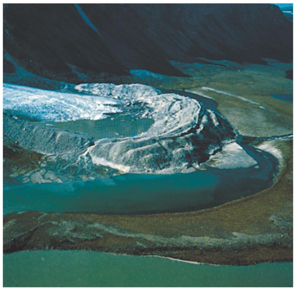
10 Nonmarine Environments Glaciers Indicate cold climates Scratches produced by glacial motion Record direction of motion 10

11 Nonmarine Environments Meltwater Transports sediments from glacier Forms streams and lakes Outwash Well-stratified layers of sediment Varve Annual layers of alternating coarse and fine sediments 11

12 Nonmarine Environments Till Unsorted, heterogeneous material Tillite Lithified till Moraine Ridges of till plowed up at the farthest edge of the glacier 12

13
14 Moraines - Till

15 Till Tillite

16 Tillite

17 Nonmarine Environments Varves Annual record Count! Dropstones Scattered coarse sediments found in sediment matrix Ice-rafted debris 17

18 Nonmarine Environments Desert soils Little organic matter Evaporite minerals Interior drainage Precipitation does not leave the basin Playa lake Temporary lakes Associated with evaporites 18

19 Nonmarine Environments Dunes Piles of sand < 1% of deserts Moves with prevailing wind direction Associated with deserts and beaches 19

20 Desert Dunes

21 Desert Dunes
22 Rocks from Desert Dunes
23 Cross Beds Zion National Park, UT
24
25 Cross bedding: Zion National Park Rocks from Desert Dunes
26 Rocks from Desert Dunes Cross bedding: Kaibab Sandstone, Zion National Park
27 Rocks from Desert Dunes
28 Aeolian (deserts) Rivers and Beaches Crossbeds
29 Fig. 7-19, p. 218
30 Nonmarine Environments Dune migration Moves downwind Sands move up and over top; accumulate on downwind side Trough cross- stratification Direction changes with prevailing winds Beds accumulate on curved surface cut through older beds 30
31 Nonmarine Environments Alluvial fans Low, cone-shaped structures Develop where mountain slope meets valley floor Change in slope reduces stream velocity Sediments settle out Braided streams form 31
32 Alluvial Fans
33 Rocks from Alluvial Fans
34 Nonmarine Environments Mudcracks Polygonal shape Form from alternate wetting and drying Associated with evaporites Halite Gypsum Anhydrite 34
35 Nonmarine Environments RIVERS and STREAMS Waters move from mountains to sea through a variety of depositional environments Braided streams Meandering rivers Marginal marine systems 35
36 Nonmarine Environments Braided streams More sediment available than the water can transport Forms numerous channels and bars 36
37 The North Platte River: A Braided Stream
38 A braided stream in its floodplain: Alaska
39 Nonmarine Environments Meandering River Abundant water relative to sediment Backswamps Flood plain Mud settles out when stream overflows 39
40 Nonmarine Environments Point bar Slowest flow on inner bend Accumulate sands Fastest flow on the outer bank Cuts away bank Natural levees Form during floods Coarsest sands deposited first, then fines 40
41 A braided stream in its floodplain: Laramie River
42 Oxbow lakes in a floodplain
43
44 River channels
45 River channels
46
47
48 Riparian foliage in a floodplain
49 Marginal Marine Delta Depositional body of sand, silt, and clay formed when river empties into the sea Sediments settle out in sequence What did the ocean say to the land? 49
50
51 The Ganges River Delta
52 Marginal Marine Delta plain Layers of sand and silt deposited as river nears sea Distributary channels Separated by levees Delta front Silt and clay slope deposits Prodelta Clays often deposited by a freshwater plume Progrades into basin Sediments coarsen upward 52
53 Marginal Marine Mississippi River Delta River dominated delta Progrades into Gulf of Mexico Lobes Growing portion of the delta 53
54 Marginal Marine Mississippi River Delta Active lobe Growing portion of delta Switched lobes in the past Abandoned lobe Sediments compact Lobe sinks New lobe forms on top 54
55
56 Aside: What happens when sea level changes? Marine Transgression = Sea Level Rise Marine Regression = Sea Level Fall
57 Blue = No deposition
58 Walther s Law Sedimentary environments that started out side-by-side will end up overlapping one another over time due to transgressions and regressions. Facies Limestone Shale Siltstone Sandstone Reef Lagoon Near Shore Beach Environment
59 Marine Trangression Walther s Law
60 Marine Regression
61 Fig Sequence of sediments deposited by transgression and regression of shallow sea
62 The sea goes in, the sea goes out.
63 Back to Marginal Marine Deltaic Cycles Sequence of deposition Coarsens upward Erosion can remove tops 63
64 Marginal Marine Barrier-Island Lagoon Complex Barrier Islands Waves and currents pile up sands Longshore Current Lagoons Protected from strong waves behind barriers Muds and muddy sands 64
65 Marginal Marine Progradation Shoreline builds out into sea High supply of sediment Builds over deeper water environments Illustrates Walther s Law 65
66 Marginal Marine Fossils Useful in reconstructing environments of past 66
67 Marine Tempestites Storm deposits on shelf Sands deposited within normal muds and muddy sands 67
68 Organic reefs Modern reefs formed from coral Ancient reefs formed from different organisms Carbonate Systems 68
69 Carbonate Systems Reef front Seaward side Often rubble called talus Reef flat Lagoon On leeward side Patch reef 69
70 Carbonate Systems 70
71 Carbonate Systems Barrier reefs Elongate reefs with lagoon behind Fringing Reefs Grow along coast Lack lagoon 71
72 Carbonate Systems Atolls Reefs on volcanic islands Darwin Formed by sinking island Up to 65 km across Often open at one end 72
73 Carbonate Systems Buried atolls Often important petroleum reservoirs 73
74 Carbonate Systems Carbonate Platform Broad carbonate structure above seafloor Windward side Nutrient rich Abundant reefs Buffered system CO 2 + H 2 O = H 2 CO 3 HCO 3 + CaCO 3 = 2HCO- 3 74
75 Carbonate Systems Stromatolites Cyanobacteria mats trap sediments Grows up through sediments to produce new one Layered organicrich and organicpoor muds 75
76 Carbonate Systems Living Stromatolites Found in hypersaline, supratidal and intertidal settings Little competition and predation Shark Bay, Australia 76
77 Deep Sea Environments Turbidity current Dense sediment-laden flow driven by gravity Turbidite Produces graded deposit Poorly sorted coarse grains at base Fine grains at top 77
78 Deep Sea Environments Turbidites are common in canyons Drop sediment load at base Form deposit similar to alluvial fan 78
79 Deep Sea Environments Pelagic sediment Fine-grained sediments that accumulate by settling through the water column Calcium carbonate Silica Clay 79
80 Deep Sea Environments Calcareous ooze Accumulations of singlecelled planktonic organisms Foraminifera Calcareous nannoplankton Common < 4 km w.d. Dissolution increases below 4 km w.d. 80
81 Deep Sea Environments Siliceous ooze Diatoms Radiolarians Common in upwelling regions Accumulations can alter to opal then chert 81
82 82
83 Alluvial fans in Death Valley
84
85 Coral Reefs
86 Fig , p. 336
87 Fig a, p. 338
88 Great Barrier Reef Australia Fig , p. 261
89 Fig d, p. 339
90 Fig , p. 337
91 Reefs Coastal feature of biological origin Complex community of coral, algae & other marine animals living in warm seas Reef structure has large influence on coastal processes
FROM SEDIMENT INTO SEDIMENTARY ROCK. Objectives. Sediments and Sedimentation
 FROM SEDIMENT INTO SEDIMENTARY ROCK Objectives Identify three types of sediments. Explain where and how chemical and biogenic sediments form. Explain three processes that lead to the lithification of sediments.
All sediments have a source or provenance, a place or number of places of origin where they were produced.
 Sedimentary Rocks, Processes, and Environments Sediments are loose grains and chemical residues of earth materials, which include things such as rock fragments, mineral grains, part of plants or animals,
7) A clastic sedimentary rock composed of rounded to subrounded gravel is called a A) coal. B) shale. C) breccia.
 A clastic sedimentary rock composed of rounded to subrounded gravel is called a A) coal. B) shale. C) breccia.") Please read chapters 10 and 5 CHAPTER 5 Sedimentary Rocks 1) Sedimentary rocks A) form by compaction and cementation of loose sediment. B) are widespread on the continents and ocean floor. C) are common
Please read chapters 10 and 5 CHAPTER 5 Sedimentary Rocks 1) Sedimentary rocks A) form by compaction and cementation of loose sediment. B) are widespread on the continents and ocean floor. C) are common
SEDIMENTARY ROCKS. Sedimentary rocks are formed near or at the surface of the earth.
 SEDIMENTARY ROCKS Sedimentary rocks are formed near or at the surface of the earth. They are derived from preexisting source rocks. They are composed by sediments, this is material that has been weathered,
Sedimentary Rocks Practice Questions and Answers Revised September 2007
 Sedimentary Rocks Practice Questions and Answers Revised September 2007 1. Clastic sedimentary rocks are composed of and derived from pre-existing material. 2. What is physical weathering? 3. What is chemical
WEATHERING, EROSION, AND DEPOSITION PRACTICE TEST. Which graph best shows the relative stream velocities across the stream from A to B?
 NAME DATE WEATHERING, EROSION, AND DEPOSITION PRACTICE TEST 1. The diagram below shows a meandering stream. Measurements of stream velocity were taken along straight line AB. Which graph best shows the
Sediment and Sedimentary Rocks
 Page 1 of 10 EENS 1110 Tulane University Physical Geology Prof. Stephen A. Nelson Sediment and Sedimentary Rocks This page last updated on 15-Sep-2015 Sedimentary Rocks Rivers, oceans, winds, and rain
Characteristics of Sedimentary Rocks
 Characteristics of Sedimentary Rocks Deposited at the earth s surface by wind, water, glacier ice, or biochemical processes Typically deposited in strata (layers) under cool surface conditions. This is
Chapter 5 - Sediments
 Chapter 5 - Sediments Distribution of sediments on the sea floor Seabed Resources Study of Sediments is important to oceanography because: 1. Sediments and volcanism are the most important agents of physical
What are the controls for calcium carbonate distribution in marine sediments?
 Lecture 14 Marine Sediments (1) The CCD is: (a) the depth at which no carbonate secreting organisms can live (b) the depth at which seawater is supersaturated with respect to calcite (c) the depth at which
Deserts, Wind Erosion and Deposition
 Deserts, Wind Erosion and Deposition By definition, a desert has less than 10 in (25 cm) of precipitation per year. Deserts occur at 30 o and 60 o in regions of descending air. Deserts can be hot or cold.
Sedimentary Rocks, Depositional Environments and Stratigraphy
 Sedimentary Rocks, Depositional Environments and Stratigraphy The Nature of Sedimentary Rocks Sedimentary rocks are composed of: Fragments of other rocks (detrital or clastic) Chemical precipitates Organic
Last Time. Sedimentary Facies. Facies Modeling. Walther s Law. Overall beach dynamics. MAS 603: Geological Oceanography
 UNIVERSITY OF SOUTH ALABAMA Last Time MAS 603: Geological Oceanography Lecture 13: Sedimentary Facies Facies versus depositional environments Walther s Law Beaches Sedimentary Facies Facies Modeling There
WEATHERING, EROSION, and DEPOSITION REVIEW
 WEATHERING, EROSION, and DEPOSITION REVIEW Weathering: The breaking up of rock from large particles to smaller particles. a) This Increases surface area of the rock which speeds the rate of chemical weathering.
The concepts developed in this standard include the following: Oceans cover about 70% of the surface of the Earth.
 Name Date Grade 5 SOL 5.6 Review Oceans Made by SOLpass - www.solpass.org solpass100@comcast.net Reproduction is permitted for SOLpass subscribers only. The concepts developed in this standard include
Rocks & Minerals. 10. Which rock type is most likely to be monomineralic? 1) rock salt 3) basalt 2) rhyolite 4) conglomerate
 rock salt 3) basalt 2) rhyolite 4) conglomerate") 1. Of the Earth's more than 2,000 identified minerals, only a small number are commonly found in rocks. This fact indicates that most 1) minerals weather before they can be identified 2) minerals have
1. Of the Earth's more than 2,000 identified minerals, only a small number are commonly found in rocks. This fact indicates that most 1) minerals weather before they can be identified 2) minerals have
8/18/2014. Chapter 9: Erosion and Deposition. Section 1 (Changing Earth s Surface) 8 th Grade. Weathering
 8 th Grade. Weathering") Section 1 (Changing Earth s Surface) Weathering the chemical and physical processes that break down rock at Earth s surface Chapter 9: Erosion and Deposition 8 th Grade Mechanical weathering when rock
Section 1 (Changing Earth s Surface) Weathering the chemical and physical processes that break down rock at Earth s surface Chapter 9: Erosion and Deposition 8 th Grade Mechanical weathering when rock
Earth Science. River Systems and Landforms GEOGRAPHY 1710. The Hydrologic Cycle. Introduction. Running Water. Chapter 14.
 Earth Science GEOGRAPHY 1710 River Systems and Landforms DAVID R. SALLEE Robert W. Christopherson Charlie Thomsen Chapter 14 Introduction Rivers and streams are dynamic systems that continually adjust
GEOL 104 Dinosaurs: A Natural History Geology Assignment. DUE: Mon. Sept. 18
 GEOL 104 Dinosaurs: A Natural History Geology Assignment DUE: Mon. Sept. 18 Part I: Environments of Deposition Geologists can use various clues in sedimentary rocks to interpret their environment of deposition:
Communities, Biomes, and Ecosystems
 Communities, Biomes, and Ecosystems Before You Read Before you read the chapter, respond to these statements. 1. Write an A if you agree with the statement. 2. Write a D if you disagree with the statement.
Sedimentary Rocks. Find and take out 11B-15B and #1 From Egg Carton
 Sedimentary Rocks Find and take out 11B-15B and #1 From Egg Carton Erosion Erosion is a natural process where rocks and soil are Broken and Moved We will focus on 4 types of erosion; Wind, Rain, Ice and
Ocean Floor Continental Slope Begins at the Continental Shelf Very sharp drop to depths over 2 miles Covered with thick layers of sand, mud, and rocks
 Ocean Floor Continental Shelf Begins at the shoreline Gently slopes underwater Average depth of 430 feet Thick layers of sand, mud, and rocks The beach is part of the Continental Shelf Ocean Floor Continental
Igneous rocks formed when hot molten material (magma) cools and hardens (crystallizes).
 cools and hardens (crystallizes).") Objectives You will learn about how the land of North Dakota was formed. Introduction North Dakota is a wonderful place to live. Have you ever though about how it was formed? To answer that question, you
Objectives You will learn about how the land of North Dakota was formed. Introduction North Dakota is a wonderful place to live. Have you ever though about how it was formed? To answer that question, you
Coral Reefs Lecture Notes
 Coral Reefs Lecture Notes (Topic 10D) page 1 Coral Reefs Lecture Notes Corals Polyps & Zooxanthellae Coral Polyps Are coral polyps algae or animals? Description (What do coral polyps look like? Make a
2 Wind Erosion and Deposition
 CHAPTER 3 2 Wind Erosion and Deposition SECTION Agents of Erosion and Deposition BEFORE YOU READ After you read this section, you should be able to answer these questions: How can wind erosion shape the
Climate, Vegetation, and Landforms
 Climate, Vegetation, and Landforms Definitions Climate is the average weather of a place over many years Geographers discuss five broad types of climates Moderate, dry, tropical, continental, polar Vegetation:
Carbonate Rock Formation
 Limestone, dolomite (or dolostone), and marble are often collectively referred to as carbonate rocks because the main mineral is calcite. The chemical name of calcite is calcium carbonate. Limestone, dolomite,
1. The diagram below shows a cross section of sedimentary rock layers.
 1. The diagram below shows a cross section of sedimentary rock layers. Which statement about the deposition of the sediments best explains why these layers have the curved shape shown? 1) Sediments were
How Did These Ocean Features and Continental Margins Form?
 298 10.14 INVESTIGATION How Did These Ocean Features and Continental Margins Form? The terrain below contains various features on the seafloor, as well as parts of three continents. Some general observations
Earth Science Chapter 14 Section 2 Review
 Name: Class: Date: Earth Science Chapter 14 Section Review Multiple Choice Identify the choice that best completes the statement or answers the question. 1. Which of the following is NOT one of the three
5 th Grade Science Vocabulary Words
 5 th Grade Science Vocabulary Words abiotic factor A nonliving part of an ecosystem. acceleration Change in velocity with respect to time. action The force one object applies to a second, as in Newton
Glacier Erosion Notes
 Name Date ES per Mr. Landsman Glacier Erosion Notes Erosion: the of weathered material. Glacier: A large mass of ice and snow that exists year-round and moves under the influence of. Evidence for Glacier
Weathering, Erosion, and Soils. Weathering and Erosion. Weathering and Erosion
 Weathering, Erosion, and Soils 1 The Grand Canyon, a landscape shaped by weathering and erosion 2 Weathering vs. erosion Types of weathering Physical Chemical Rates of weathering and erosion Climate Rock
6. Base your answer to the following question on the graph below, which shows the average monthly temperature of two cities A and B.
 1. Which single factor generally has the greatest effect on the climate of an area on the Earth's surface? 1) the distance from the Equator 2) the extent of vegetative cover 3) the degrees of longitude
Chapter 3 Communities, Biomes, and Ecosystems
 Communities, Biomes, and Ecosystems Section 1: Community Ecology Section 2: Terrestrial Biomes Section 3: Aquatic Ecosystems Click on a lesson name to select. 3.1 Community Ecology Communities A biological
Chesapeake Bay Governor School for Marine and Environmental Science
 Choose the best answer and write on the answer sheet provided. 1. Which of the following is LEAST likely to be an effect of global warming? (a) Loss of fertile delta regions for agriculture (b) Change
TECTONICS ASSESSMENT
 Tectonics Assessment / 1 TECTONICS ASSESSMENT 1. Movement along plate boundaries produces A. tides. B. fronts. C. hurricanes. D. earthquakes. 2. Which of the following is TRUE about the movement of continents?
Ride the Rock Cycle. Suggested Goals: Students will gain an understanding of how a rock can move through the different stages of the rock cycle.
 Illinois State Museum Geology Online http://geologyonline.museum.state.il.us Ride the Rock Cycle Grade Level: 5 6 Purpose: To teach students that the rock cycle, like the water cycle, has various stages
1. A student found a sample of a solid material that was gray, shiny and made of all the same material. What category does this sample best fit?
 Grade 4 Standard 3 Unit Test A Earth Materials Multiple Choice 1. A student found a sample of a solid material that was gray, shiny and made of all the same material. What category does this sample best
Geologic History Review
 1. The climate that existed in an area during the early Paleozoic Era can best be determined by studying (1) the present climate of the area (2) recorded climate data of the area since 1700 (3) present
The rock cycle. Introduction. What are rocks?
 The rock cycle This Revision looks at the three types of rock: sedimentary, igneous and metamorphic. It looks at how they are formed, the weathering of rocks and the way one form of rock turns into another,
Rapid Changes in Earth s Surface
 TEKS investigate rapid changes in Earth s surface such as volcanic eruptions, earthquakes, and landslides Rapid Changes in Earth s Surface Constant Changes Earth s surface is constantly changing. Wind,
Name Date Hour. Plants grow in layers. The canopy receives about 95% of the sunlight leaving little sun for the forest floor.
 Name Date Hour Directions: You are to complete the table by using your environmental text book and the example given here. You want to locate all the abiotic (non-living) and biotic (living) factors in
What is a rock? How are rocks classified? What does the texture of a rock reveal about how it was formed?
 CHAPTER 4 1 The Rock Cycle SECTION Rocks: Mineral Mixtures BEFORE YOU READ After you read this section, you should be able to answer these questions: What is a rock? How are rocks classified? What does
Biomes An Overview of Ecology Biomes Freshwater Biomes
 Biomes An Overview of Ecology Ecology is the scientific study of the interactions between organisms and their environments. Ecology can be divided into four increasingly comprehensive levels: Organismal
Continental Drift. Alfred Wegener (1880-1930) Proposed that all of the continents were once part of a large supercontinent - Pangaea Based on:
 Proposed that all of the continents were once part of a large supercontinent - Pangaea Based on:") Plate Tectonics and Continental Drift Continental Drift Alfred Wegener (1880-1930) Proposed that all of the continents were once part of a large supercontinent - Pangaea Based on: Similarities in shorelines
Plate Tectonics and Continental Drift Continental Drift Alfred Wegener (1880-1930) Proposed that all of the continents were once part of a large supercontinent - Pangaea Based on: Similarities in shorelines
Chapter Overview. Bathymetry. Measuring Bathymetry. Echo Sounding Record. Measuring Bathymetry. CHAPTER 3 Marine Provinces
 Chapter Overview CHAPTER 3 Marine Provinces The study of bathymetry charts ocean depths and ocean floor topography. Echo sounding and satellites are efficient bathymetric tools. Most ocean floor features
Course Plan Day 1: Introduction and Overview Hydrology & Fluvial Geomorphology Day 2: Fieldwork on the Braid Burn Alan Jones
 Course Plan Day 1: Introduction and Overview Hydrology & Fluvial Geomorphology Alan Jones E:mail: Alan.Jones@ed.ac.uk Water cycle Globally & Locally River shapes and forms River behaviour Closer look at
Geomorphology is the Study of Landforms. Usually by Erosion, Transportation and Deposition
 Geomorphology is the Study of Landforms and the Processes that t Create Them, Usually by Erosion, Transportation and Deposition Fluvial = running water, rivers and floodplains Glacial = flowing ice in
Basic Soil Erosion and Types
 Basic Soil Erosion and Types 2015 Wisconsin Lakes Convention Stacy Dehne DATCP Engineer Types of Soil Erosion Rain drop or splash erosion: Erosion preceded by the destruction of the crumb structure due
College of Science and Health ENVIRONMENTAL SCIENCE & GEOGRAPHY Course Outline
 College of Science and Health ENVIRONMENTAL SCIENCE & GEOGRAPHY Course Outline 1. TITLE OF COURSE AND COURSE NUMBER: General Geology ENV 115, 4 credits 2. DESCRIPTION OF THE COURSE: Includes the study
Foundations of Earth Science (Lutgens and Tarbuck, 5 th edition, 2008)
") EAS 100 Study Guide to Textbook Foundations of Earth Science (Lutgens and Tarbuck, 5 th edition, 2008) STUDY GUIDE 1/08 The textbook for EAS 100, Foundations of Earth Science, by Lutgens and Tarbuck is
EAS 100 Study Guide to Textbook Foundations of Earth Science (Lutgens and Tarbuck, 5 th edition, 2008) STUDY GUIDE 1/08 The textbook for EAS 100, Foundations of Earth Science, by Lutgens and Tarbuck is
Foundations of Earth Science (Lutgens and Tarbuck, 6 th edition, 2011)
") EAS 100 Study Guide to Textbook Foundations of Earth Science (Lutgens and Tarbuck, 6 th edition, 2011) STUDY GUIDE 8/2010 The textbook for EAS 100, Foundations of Earth Science, by Lutgens and Tarbuck
EAS 100 Study Guide to Textbook Foundations of Earth Science (Lutgens and Tarbuck, 6 th edition, 2011) STUDY GUIDE 8/2010 The textbook for EAS 100, Foundations of Earth Science, by Lutgens and Tarbuck
Ch6&7 Test. Multiple Choice Identify the choice that best completes the statement or answers the question.
 Ch6&7 Test Multiple Choice Identify the choice that best completes the statement or answers the question. 1. Which of the following does NOT change the form of existing rock? a. tremendous pressure c.
Floodplain Connectivity in Restoration Design
 Floodplain Connectivity in Restoration Design 2015 Symposium on Restoration in a Contaminated Environment: Lessons Learned and Challenges in Moving Forward Part II April 2015 Karin Boyd Applied Geomorphology,
LEARNING THE LANDFORMS Grade Level: Third Presented by: Elizabeth Turcott, Endeavor Charter Academy, Springfield, Michigan Length of Unit: 14 lessons
 LEARNING THE LANDFORMS Grade Level: Third Presented by: Elizabeth Turcott, Endeavor Charter Academy, Springfield, Michigan Length of Unit: 14 lessons I. ABSTRACT This unit develops an understanding of
Rocks and Plate Tectonics
 Name: Class: _ Date: _ Rocks and Plate Tectonics Multiple Choice Identify the choice that best completes the statement or answers the question. 1. What is a naturally occurring, solid mass of mineral or
The Next Generation Science Standards (NGSS) Correlation to. EarthComm, Second Edition. Project-Based Space and Earth System Science
 Correlation to. EarthComm, Second Edition. Project-Based Space and Earth System Science") The Next Generation Science Standards (NGSS) Achieve, Inc. on behalf of the twenty-six states and partners that collaborated on the NGSS Copyright 2013 Achieve, Inc. All rights reserved. Correlation to,
The Next Generation Science Standards (NGSS) Achieve, Inc. on behalf of the twenty-six states and partners that collaborated on the NGSS Copyright 2013 Achieve, Inc. All rights reserved. Correlation to,
principles of stratigraphy: deposition, succession, continuity and correlation
 Relative Age Dating Comparative Records of Time Nature of the rock record principles of stratigraphy: deposition, succession, continuity and correlation Stratigraphic tools biological succession of life:
Ecosystems One or more communities in an area and the abiotic factors, including water, sunlight, oxygen, temperature, and soil.
 7-4.1 Summarize the characteristics of the levels of organization within ecosystems (including populations, communities, habitats, niches, and biomes). Taxonomy level: 2.4-B Understand Conceptual Knowledge
Sedimentary Rock Formation Models. 5.7 A Explore the processes that led to the formation of sedimentary rock and fossil fuels.
 Sedimentary Rock Formation Models 5.7 A Explore the processes that led to the formation of sedimentary rock and fossil fuels. The Formation Process Explained Formation of these rocks is one of the important
THE AINSA BASIN: - A FIELD TRIP
 : - A FIELD TRIP Tom Erik Maast and Lars-Christian Røsberg Universitetet i Oslo, Institutt for geofag. Desember 2006 ABSTRACT The Ainsa Basin is a piggy-back basin part of the south Pyrenean Gavarine thrust
GY301 Geomorphology Fluvial Erosion Landforms
 Introduction Running water is by far the most important erosional agent on Earth. Even in arid climates, it is the primary agent of erosion. This is evident from the abundance of stream beds found throughout
Water & Climate Review
 Water & Climate Review 1. The cross section below shows the direction of air flowing over a mountain. Points A and B are at the same elevation on opposite sides of the mountain. 4. The graph below shows
There are many ways of differentiating the activity and tweaking it to suit the needs of pupils, these notes outline some possible strategies:
 How the mystery works There are many ways of differentiating the activity and tweaking it to suit the needs of pupils, these notes outline some possible strategies: The cards (see below) should be copied,
Rocks and Minerals What is right under your feet?
 Rocks and Minerals What is right under your feet? Name: 1 Before you start What do you already know? What is the difference between a rock and a mineral? What are the three categories of rocks? 1. 2. 3.
5-Minute Refresher: WEATHERING AND EROSION
 5-Minute Refresher: WEATHERING AND EROSION Weathering and Erosion Key Ideas Weathering is the wearing away of the surface of rock, soil, and minerals into smaller pieces. Example of weathering: Wind and
GLOSSARY OF TERMS CHAPTER 11 WORD DEFINITION SOURCE. Leopold
 CHAPTER 11 GLOSSARY OF TERMS Active Channel The channel that contains the discharge Leopold where channel maintenance is most effective, sediment are actively transported and deposited, and that are capable
Aquatic Biomes, Continued
 Aquatic Biomes, Continued Introduction Extent of Marine biomes Issues & challenges Factors influencing distribution Dynamics in time & space Depth Tour of marine biomes Issues (by biome) Freshwater biomes
ANATOMY OF A MUDSLIDE AND DAMAGE CAUSED BY HURRICANE IVAN
 ANATOMY OF A MUDSLIDE AND DAMAGE CAUSED BY HURRICANE IVAN by Jim Hooper, Fugro-McClelland Marine Geosciences Presented at the Houston Marine Insurance Seminar Westin Galeria Hotel, Houston Texas September
Topics: The Petroleum System. Origin of Petroleum. Arguments for biogenic origin. Google search : Origin of Petroleum : Hugoton Gas Field (Kansas)
") The Petroleum System Topics: Origin of Petroleum Controversy Carbon Cycle Global Implications Petroleum System Gas Oil Water Origin of Petroleum Long standing debate: Where does rock oil come from? Organic
The Petroleum System Topics: Origin of Petroleum Controversy Carbon Cycle Global Implications Petroleum System Gas Oil Water Origin of Petroleum Long standing debate: Where does rock oil come from? Organic
Final Project Report
 CURTIN UNIVERSITY OF TECHNOLOGY Department of Applied Geology Western Australia School of Mines Applied Sedimentology, Coastal and Marine Geoscience Group GERALDTON EMBAYMENTS COASTAL SEDIMENT BUDGET STUDY
The Geology of the Marginal Way, Ogunquit, Maine
 Geologic Site of the Month February, 2002 The Geology of the Marginal Way, Ogunquit, Maine 43 14 23.88 N, 70 35 18.36 W Text by Arthur M. Hussey II, Bowdoin College and Robert G. Marvinney,, Department
1. Which weather station model for a New York State location indicates that snow may be about to fall?
 1. Which weather station model for a New York State location indicates that snow may be about to fall? 4. Weather-station measurements indicate that the dewpoint temperature and air temperature are getting
Great Barrier Reef Marine Park sedimentology revealed
 issue 84 Dec 2006 Great Barrier Reef Marine Park sedimentology revealed New research into inter-reefal environments will assist reef managers Emma Mathews and Andrew Heap Geoscience Australia has completed
ebb current, the velocity alternately increasing and decreasing without coming to
 Slack water (slack tide): The state of a tidal current when its velocity is near zero, especially the moment when a reversing current changes its direction and its velocity is zero. The term is also applied
1. Michigan Geological History Presentation (Michigan Natural Resources)
") 1. Michigan Geological History Presentation (Michigan Natural Resources) The Michigan Geological History Presentation provides an overview of the approximately 3 billion years of Earth Processes that the
1. Michigan Geological History Presentation (Michigan Natural Resources) The Michigan Geological History Presentation provides an overview of the approximately 3 billion years of Earth Processes that the
Seasonal Changes in the Mekong River Delta's Distributary Channels and Nearshore Sedimentary Environments
 DISTRIBUTION STATEMENT A. Approved for public release; distribution is unlimited. Seasonal Changes in the Mekong River Delta's Distributary Channels and Nearshore Sedimentary Environments LONG-TERM GOALS
http://video.nationalgeographic.com/video/oceans narrated by sylvia earle/oceans overview 71% is covered by the Earth's Ocean
 Chapter 13 Exploring the Oceans Section 1 Earth's Ocean List the major divisions of the global ocean. Describe the history of Earth's oceans Identify the properties of ocean water. Describe the interactions
6.E.2.2 Plate Tectonics, Earthquakes and Volcanoes
 Name: Date: 1. The road shown below was suddenly broken by a natural event. 3. The convergence of two continental plates would produce Which natural event most likely caused the crack in the road? island
NATURAL RESOURCES & NATURAL FEATURES
 A3 NATURAL RESOURCES & NATURAL FEATURES INTRODUCTION This chapter will discuss the topography, geology, soils, and other natural features found in Casco Township. The identification of the natural features
Environmental Science Science Curriculum Framework. Revised 2005
 Environmental Science Science Curriculum Framework Revised 2005 Course Title: Environmental Science Course/Unit Credit: 1 Course Number: 424020 Teacher Licensure: Please refer to the Course Code Management
The Hydrologic Cycle. precipitation evaporation condensation transpiration infiltration surface runoff transport groundwater water table.
 The Hydrologic Cycle Page 1 of 1 Name Directions: The hydrologic cycle consists of the processes that change and move water through the earth s system. Use the terms below to label the hydrologic cycle.
SEDIMENTARY ROCKS. Teacher Guide including Lesson Plans, Student Readers, and More Information
 SEDIMENTARY ROCKS Teacher Guide including Lesson Plans, Student Readers, and More Information Lesson 1 - Overview of Sedimentary Rocks Lesson 2 - Classifying Sedimentary Rocks Lesson 3 - Sand (Lab) Lesson
Plate Tectonics Short Study Guide
 Name: Class: Date: Plate Tectonics Short Study Guide Multiple Choice Identify the letter of the choice that best completes the statement or answers the question. 1. The existence of coal beds in Antarctica
Web of Water. Teacher s Guide Webisode 1 Blue Ridge
 Web of Water Teacher s Guide Webisode 1 Blue Ridge Table of Contents About Blue Ridge.... 3 South Carolina Science Standards.. 4 Discussion Questions.. 10 Knowitall Resources....... 13 Credits..... 14
Lecture 23: Terrestrial Worlds in Comparison. This lecture compares and contrasts the properties and evolution of the 5 main terrestrial bodies.
 Lecture 23: Terrestrial Worlds in Comparison Astronomy 141 Winter 2012 This lecture compares and contrasts the properties and evolution of the 5 main terrestrial bodies. The small terrestrial planets have
Summary of Basalt-Seawater Interaction
 Summary of Basalt-Seawater Interaction Mg 2+ is taken up from seawater into clay minerals, chlorite, and amphiboles, in exchange for Ca 2+, which is leached from silicates into solution. K + is taken up
Glacial Meltwater Landforms
 Canadian Landscapes Fact Sheets Glacial Meltwater Landforms A melting ice sheet produces a huge amount of water that runs off the ice or forms lakes in front of it. Several distinctive landforms and are
Chapter 18 Introduction to. A f r i c a
 Chapter 18 Introduction to A f r i c a Ch. 18:1 Landforms & Resources 1. Africa s shape & landforms are the result of its location in the southern part of the ancient supercontinent of. Pangaea Over thousands
SLOPE AND TOPOGRAPHY
 SLOPE AND TOPOGRAPHY What are Slope and Topography? Slope and topography describe the shape and relief of the land. Topography is a measurement of elevation, and slope is the percent change in that elevation
Georgia Performance Standards Framework for Science Grade 6. Unit Organizer: Water in Earth s Processes. (Approximate Time: 5-6 Weeks)
") The following instructional plan is part of a GaDOE collection of Unit Frameworks, Performance Tasks, examples of Student Work, and Teacher Commentary. Many more GaDOE approved instructional plans are
The following instructional plan is part of a GaDOE collection of Unit Frameworks, Performance Tasks, examples of Student Work, and Teacher Commentary. Many more GaDOE approved instructional plans are
Instructor: Ms. Terry J. Boroughs Geology 305 INTRODUCTION TO ROCKS AND THE ROCK CYCLE
 DATE DUE: Name: Instructor: Ms. Terry J. Boroughs Geology 305 INTRODUCTION TO ROCKS AND THE ROCK CYCLE Instructions: Read each question carefully before selecting the BEST answer Provide specific and detailed
FIFTH GRADE ROCKS 2 WEEKS LESSON PLANS AND ACTIVITIES
 FIFTH GRADE ROCKS 2 WEEKS LESSON PLANS AND ACTIVITIES WEEK 1. PRE: Describing a chemical reaction. LAB: Illustrating how molecules move. POST: Comparing salt and sugar crystals. ROCK CYCLE OVERVIEW OF
Water and Weathering. Chapter 11
 Chapter 11 Water and Weathering In Unit 2, you learned about energy in the Earth system. In Unit 3, you learned about plate tectonics, earthquakes, and volcanoes. These are examples of Earth systems that
Neversink River East Branch
 Neversink River East Branch Management Unit 10 Summary of Post-Flood Recommendations Intervention Level Full restoration of the stream reach including the eroding bank site between Station 38380 and Station
Instructor: Ms. Terry J. Boroughs Geology 305 INTRODUCTION TO ROCKS AND THE ROCK CYCLE
 DATE DUE: Name: Instructor: Ms. Terry J. Boroughs Geology 305 INTRODUCTION TO ROCKS AND THE ROCK CYCLE Instructions: Read each question carefully before selecting the BEST answer Provide specific and detailed
ES Chapter 10 Review. Name: Class: Date: Multiple Choice Identify the choice that best completes the statement or answers the question.
 Name: Class: Date: ES Chapter 10 Review Multiple Choice Identify the choice that best completes the statement or answers the question. 1. Scientists used the pattern of alternating normal and reversed
Petrel TIPS&TRICKS from SCM
 Petrel TIPS&TRICKS from SCM Knowledge Worth Sharing Truncated Gaussian Algorithm Rocks that transition from one facies or facies association to the next in a specific order are common. Examples include:
Seismic stratigraphy and small 3D seismic surveys
 Seismic stratigraphy and small 3D seismic surveys BRUCE HART, SABRINA SARZALEJO, and TIM MCCULLAGH, McGill University, Montreal, Canada The establishment of seismic stratigraphic principles in the 1970s