A Revision of the Rogaland Group, Norwegian North Sea
|
|
|
- Maud Lucas
- 7 years ago
- Views:
Transcription
1 A Revision of the Rogaland Group, Norwegian North Sea Harald Brunstad1, Felix Gradstein2, Luis Vergara3, Jan Erik Lie1 and Øyvind Hammer2 1. Lundin Petroleum AS Norway, NO-1366 Lysaker, Norway 2. Geology Museum, University of Oslo, N-0318 Oslo, Norway 3. RWE Dea, Cairo, Egypt Norlex Project presentation NPD 16th of October 2009

2
3 Stratigraphic definitions in the presented work Revised nomenclature based on the guidelines from International stratigraphic Committe Keep as much as practically possible of existing naming, to avoid confusion and to Credit earlier work. Unit names from offshore: Norway UK Denmark Former Sandstone Formations already downgraded to Members by several authors, except for the Maureen formation In present work all internal sandstone units within the shale Formations on the Norwegian sector are given member status, also the sandy parts of the Maureen unit (according to our definition the Maureen Member), the fine grained parts of the former Maureen Formation are now attributed to the Våle formation

4 Development of stratigraphy Establishment of Shale Formations Deegan and Scull 1977 Accepted and relatively unchganged for Norwegian, UK and DK North Sea Westerly derived Sandstone units Deegan and Scull 1977: Several sandstone units defined as formations. Heimdal unit defined as member. Hardt et al In Isaksen and Tonstad hb1 Define all sandstone units as formations Knox & Holloway 1992 Sandstones units intra Lista and Sele Fms defined as members in the basinal areas, by Mudge and Copestake 1996: Sandstone units intra Lista, Sele and Balder Fms downgraded to members in basinal areas by. Odin Member introduced. Maureen unit still kept as formation Ahmadi et al, Millenium Atlas Norlex Present publication (In prep) all sandstone units in Norwegian sector down graded to Members. Intra Våle sandstone units defined as Ty and Maureen Members North westerly sourced sandstone units different member from those sourced from South West Easterly derived Sandstone units 1977 Fiskebank Formation defined by Deegan and Scull Egga Schiøler et al 2007 defines all SE derived sand units as Members 2009 Norlex Present publication (In prep) new NE sand Members; Sotra, Solund; Radøy Mbrs.

5 Slide 4 hb1 hbrunstad, 13/10/2009

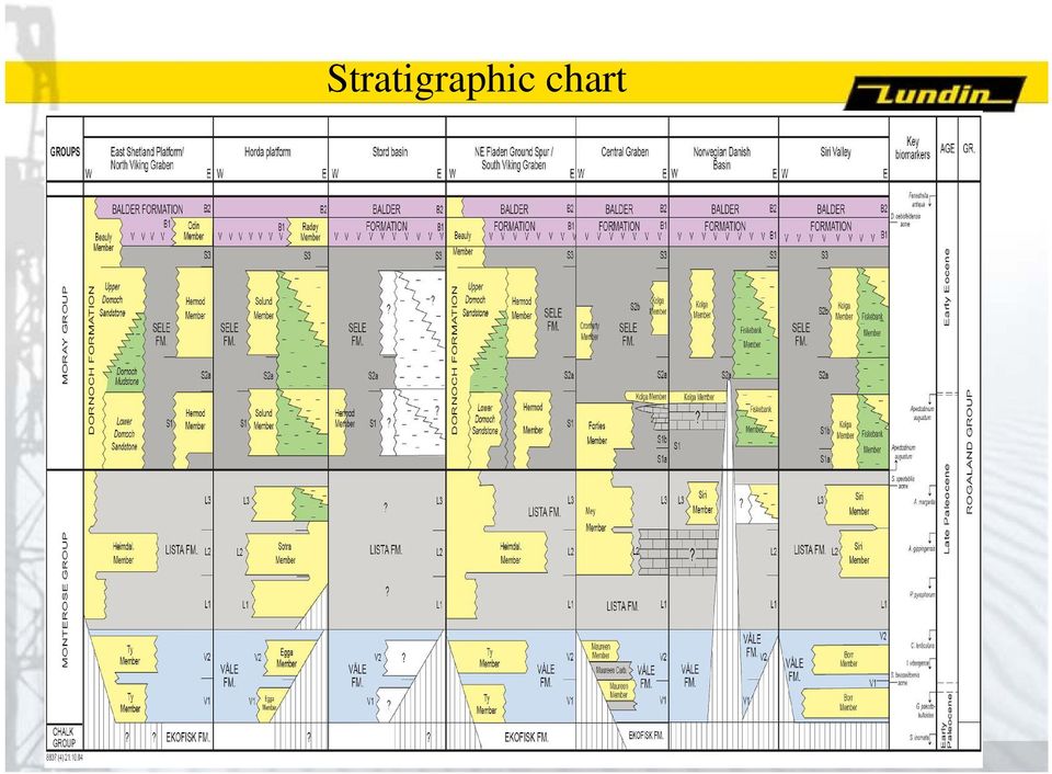
6 Table 1. Overview of the Formations and Members of the Rogaland Group, Paleocene Lower Eocene, North Sea, Norway.

7 Stratigraphic chart
8 Regional Well correlation I, Northern North Sea.

9 Seismic Key sections

10 Shale Facies Balder Fm Laminated tuffaceous Sele Fm Laminated nontuffaceous Lista Fm Non Calcareous Variable bioturbated Faintly to non Laminated Våle Fm Commonly calcareous Variable bioturbated Faintly to non Laminated Fig.11 Series of bright to medium greenish grey tuff layers of variable thickness, interlaminated with black anoxic shales. Example is taken from the Balder Formation Well 25/11-20 drilled by Norsk Hydro. Picture from NPD Faktaside at http// Fig. 93. Core photo displaying dark grey non-bioturbated shales of the Sele Formation in well 25/7-5. Photo from NPD Fact Pages at Fig. 64. Core photographies of Lista Formation well 35/10-2. Left: Sediments are composed of bioturbated green claystone with common purple red patches. Right: Nice example of Zoophycos burrows in sediments. Photographies by L.Vergara.and H.Brunstad. Fig. 46. Core example from the Våle Formation well 25/11-1 showing light to medium grey marly shales and calcite cemented fractures. Well drilled by Norsk hydro. Picture from NPD Fact Pages at

11 Sandstone Facies Fig. 21. Turbidite Example 1. Clean, massive sandstones in Heimdal Member well 25/8-6, interpreted as high density turbidites. Picture from NPD fact pages at Fig. 23. Turbidite Example 3. Normal graded beds, with sharp base and massive structure-less sandstone in lower parts of beds, and faintly cross laminated sandstones in the upper parts. Example from Heimdal Member, well 16/1-1. Deposits are interpreted as low-density turbidite deposited in a distal fan or overbank position. Picture by H. Brunstad. Fig. 23. Turbidite Example 3. Normal graded beds, with sharp base and massive structure-less sandstone in lower parts of beds, and faintly cross laminated sandstones in the upper parts. Example from Heimdal Member, well 16/1-1. Deposits are interpreted as low-density turbidite deposited in a distal fan or overbank position. Picture by H. Brunstad. Fig. 24. Turbidite Example 4. Beds of clean, massive, structure-less sandstone at top, and thinbedded, ripple cross laminated, heterolithic sandstones below. Massive sandstone is interpreted as high density turbidite deposited in a proximal/axial fan position, whereas heterolithics are interpreted as low density turbidites deposited in a fan fringe position. Example from Heimdal member, well 25/8-6. Picture from NPD fact pages at

12 Member separation lines Fig. 13. Sketch demonstrating subareas and separation lines used to limit the various sandstone members.

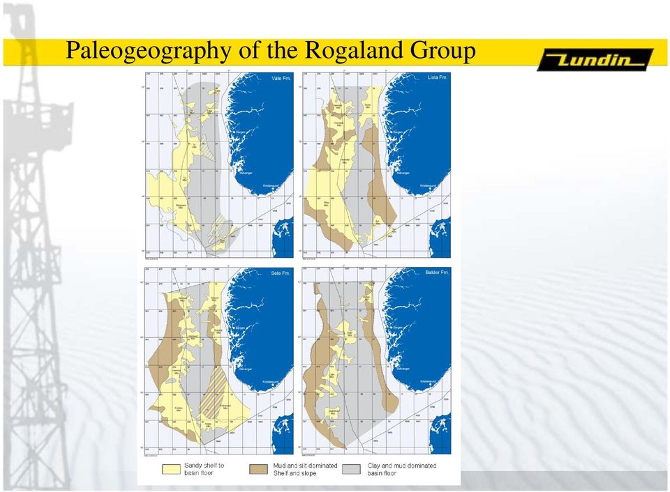
13 Paleogeography of the Rogaland Group
14 Example of shale Formation, Våle Fm Fig. 47. Example of one of the diagnostic Microfossils in the Våle Formation. Alisocysta reticulata Ventral view. Average range of type material: length = 55 µm, width = 51 µm.. From the ODP Drilling Program at http//www-odp.edu Fig. 43. Type well Well 1/3-1 composite log Rogaland Group. Stratigraphic position of the Våle Formation is outlined in the stratigraphic column to the right. Fig. 42. Distribution of the Våle Formation and its sandstone Members. Fig. 46. Core example from the Våle Formation well 25/11-1 showing light to medium grey marly shales and calcite cemented fractures. Well drilled by Norsk hydro. Picture from NPD Fact Pages at

15 Example of Sandstone Member, the Borr Member Fig. 52. Seismic SW/NE section through the Trym salt collapse structure, showing sandy interval of the Borr Member filling in a collapse feature. Fig. 50. Well 3/7-4 composite log Rogaland Group. Stratigraphic position of the Borr Member is outlined in stratigraphic column to the right. Fig. 53. Seismic map from block 3/7 and 3/8, showing amplitude at Top Våle Level. Red color shows high amplitude, and inferred presence of Borr sandstone (proven in wells).

16 Onlap/Offlap and the Vidar Member Vidar Member is not a conformable strat unit, but a part of the Vidar Olistolith. An alternative explanation of ambiguous observations across the P/E boundary Hypothesis: Basin isolation Compartmentalisation into a chain of seas Sea level fluctuations due to tectonic, eustasy and climate During lowstands roots on turbidites and basin margin collapse

17 Some ambigous observations Fig Possible shallow marine indicators from Forties Member, Well UK23/27-1 Pierce Field, close to the Norwegian UK border. Core photographs show inferred paleosols, vertical burrows of Diplocraterion type and pedogenically altered/freshwater influences carbonates. Wireline log to the left show position of shallow marine indicators relative to sandstone beds of partly turbiditic origin.

18 Possible depositional model for the Vidar Member Fig Possible depositional model for the Vidar Member, inferring that the Vidar member is a part of a mega slide or olistolith that also incorporated the siliciclastic sediments of lowerand middle parts of the Rogaland Group(Våle, Lista and Lower parts of Sele Formation). Not to scale.

19 Summary The new stratigraphy has built on and embraced the Practices in UK and Denmark The manus has been revised by John Gjelberg Tom Dreyer Vigdis Løvø Mike Charnock Jim Ogg Our results have been semi-public for Two years, and should now be public. More data will certainly improve understanding, and more revisons will come until the reservoirs are empty!

NORLEX Norwegian Interactive Offshore Stratigraphic Lexicon
 NORLEX Norwegian Interactive Offshore Stratigraphic Lexicon Felix Gradstein and Oyvind Hammer Industrial mandate to update the 20+ year old Lithostratigraphic Bulletins 1-5...1600+ wells reported with
Broadband seismic to support hydrocarbon exploration on the UK Continental Shelf
 Broadband seismic to support hydrocarbon exploration on the UK Continental Shelf Gregor Duval 1 1 CGGVeritas Services UK Ltd, Crompton Way, Manor Royal Estate, Crawley, RH10 9QN, UK Variable-depth streamer
FROM SEDIMENT INTO SEDIMENTARY ROCK. Objectives. Sediments and Sedimentation
 FROM SEDIMENT INTO SEDIMENTARY ROCK Objectives Identify three types of sediments. Explain where and how chemical and biogenic sediments form. Explain three processes that lead to the lithification of sediments.
Storing of CO 2 offshore Norway, Criteria for evaluation of safe storage sites
 Storing of CO 2 offshore Norway, Criteria for evaluation of safe storage sites Eva Halland Norwegian Petroleum Directorate Trondheim CCS Conference June 14-16, 2011 1 29.06.2011 Storing of CO 2 offshore
Sedimentary Rocks Practice Questions and Answers Revised September 2007
 Sedimentary Rocks Practice Questions and Answers Revised September 2007 1. Clastic sedimentary rocks are composed of and derived from pre-existing material. 2. What is physical weathering? 3. What is chemical
December 2007 Update
 December 2007 Update Det norske oljeselskap ASA covers all of Norway Det norske License trade E&P E&P Exploration Stavanger Oslo Trondheim Harstad 3 employees 25 employees 43 employees 10 employees Present
Lithostratigraphy. Rogaland Group
 Lithostratigraphy Cecilie-1 cm 2239 m 2240 m 2245 m 2246 m 0 10 20 30 40 50 60 70 80 90 100 Fig. 10. Core photographs showing dark grey, largely structureless, discordant, intrusive sandstones within the
Oil and gas fields in norway Industrial Heritage plan
 survey of all the areas, fields and installations on the Norwegian continental shelf. It also describes developments in these waters since the 1960s, including why Norway was able to become an oil nation,
Nautilus Global Schedule 2016
 Geophysics N004a The Essentials of Rock Physics and Seismic Amplitude Interpretation 18-21 Apr Houston, US N049a Seismic Attributes for Exploration and Reservoir Characterisation 25-29 Apr Houston, US
Topics: The Petroleum System. Origin of Petroleum. Arguments for biogenic origin. Google search : Origin of Petroleum : Hugoton Gas Field (Kansas)
") The Petroleum System Topics: Origin of Petroleum Controversy Carbon Cycle Global Implications Petroleum System Gas Oil Water Origin of Petroleum Long standing debate: Where does rock oil come from? Organic
The Petroleum System Topics: Origin of Petroleum Controversy Carbon Cycle Global Implications Petroleum System Gas Oil Water Origin of Petroleum Long standing debate: Where does rock oil come from? Organic
RESERVOIR GEOSCIENCE AND ENGINEERING
 RESERVOIR GEOSCIENCE AND ENGINEERING APPLIED GRADUATE STUDIES at IFP School from September to December RGE01 Fundamentals of Geoscience I Introduction to Petroleum Geosciences, Sedimentology RGE02 Fundamentals
Petrophysical Well Log Analysis for Hydrocarbon exploration in parts of Assam Arakan Basin, India
 10 th Biennial International Conference & Exposition P 153 Petrophysical Well Log Analysis for Hydrocarbon exploration in parts of Assam Arakan Basin, India Summary Ishwar, N.B. 1 and Bhardwaj, A. 2 *
Sedimentary Rocks. What are they and where do they form?
 Sedimentary Rocks What are they and where do they form? 1 Guiding Questions What characteristics of sedimentary rocks can we use to identify the environment of deposition, i.e., where it was formed? How
EGAS. Ministry of Petroleum
 EGAS Ministry of Petroleum EGAS Ministry of Petroleum About The Block Location: Shorouk offshore block is a part of recent relinquished of NEMED concession previously operated by Shell. It is bounded from
Sand Injectites in the North Sea and the Atlantic margin Giant fields - Infill targets - Drilling hazards - Migration paths
 FORCE Conference: Underexplored Plays, NPD, Stavanger 8-9 April 2015 Sand Injectites in the North Sea and the Atlantic margin Giant fields - Infill targets - Drilling hazards - Migration paths Mads Huuse
Seismic stratigraphy and small 3D seismic surveys
 Seismic stratigraphy and small 3D seismic surveys BRUCE HART, SABRINA SARZALEJO, and TIM MCCULLAGH, McGill University, Montreal, Canada The establishment of seismic stratigraphic principles in the 1970s
SEDIMENTARY ROCKS. Sedimentary rocks are formed near or at the surface of the earth.
 SEDIMENTARY ROCKS Sedimentary rocks are formed near or at the surface of the earth. They are derived from preexisting source rocks. They are composed by sediments, this is material that has been weathered,
All sediments have a source or provenance, a place or number of places of origin where they were produced.
 Sedimentary Rocks, Processes, and Environments Sediments are loose grains and chemical residues of earth materials, which include things such as rock fragments, mineral grains, part of plants or animals,
Search and Discovery Article #40356 (2008) Posted October 24, 2008. Abstract
 Posted October 24, 2008. Abstract") Quantifying Heterogeneities and Their Impact from Fluid Flow in Fluvial-Deltaic Reservoirs: Lessons Learned from the Ferron Sandstone Outcrop Analogue* Peter E. Deveugle 1, Matthew D. Jackson 1, Gary J.
Quantifying Heterogeneities and Their Impact from Fluid Flow in Fluvial-Deltaic Reservoirs: Lessons Learned from the Ferron Sandstone Outcrop Analogue* Peter E. Deveugle 1, Matthew D. Jackson 1, Gary J.
Petrel TIPS&TRICKS from SCM
 Petrel TIPS&TRICKS from SCM Knowledge Worth Sharing Truncated Gaussian Algorithm Rocks that transition from one facies or facies association to the next in a specific order are common. Examples include:
Rocks & Minerals. 10. Which rock type is most likely to be monomineralic? 1) rock salt 3) basalt 2) rhyolite 4) conglomerate
 rock salt 3) basalt 2) rhyolite 4) conglomerate") 1. Of the Earth's more than 2,000 identified minerals, only a small number are commonly found in rocks. This fact indicates that most 1) minerals weather before they can be identified 2) minerals have
1. Of the Earth's more than 2,000 identified minerals, only a small number are commonly found in rocks. This fact indicates that most 1) minerals weather before they can be identified 2) minerals have
FIELDS UNDER DEVELOPMENT. Ga p fr FACTS 111
 11 FIELDS UNDER DEVELOPMENT n Ga p fr 2011 FACTS 111 0 10 20 G 30 Blo pro Goliat 70 Hammerfest 70 Dis Dev Ope Lice Rec Tromsø Exp As o Bodø 65 Dev No The me ins Marulk Skarv 65 Trondheim Res and the Jur
OPPORTUNITIES IN THE UPSTREAM SECTOR OF MONTENEGRO. Vladan Dubljević Tamara Pavličić
 OPPORTUNITIES IN THE UPSTREAM SECTOR OF MONTENEGRO Vladan Dubljević Tamara Pavličić Discussion Topics Business Environment Legal and fiscal regime Petroleum policy and resource management Fiscal system
Search and Discovery Article #30121 (2010) Posted June 21, 2010. Abstract
 Posted June 21, 2010. Abstract") Role of Mass-Transport Deposit (MTD) Related Topography on Turbidite Deposition and Reservoir Architecture: A Comparative Study of the Tres Pasos Formation (Cretaceous), Southern Chile and Temburong Formation
Role of Mass-Transport Deposit (MTD) Related Topography on Turbidite Deposition and Reservoir Architecture: A Comparative Study of the Tres Pasos Formation (Cretaceous), Southern Chile and Temburong Formation
principles of stratigraphy: deposition, succession, continuity and correlation
 Relative Age Dating Comparative Records of Time Nature of the rock record principles of stratigraphy: deposition, succession, continuity and correlation Stratigraphic tools biological succession of life:
FAULT SEAL ANALYSIS: Mapping & modelling. EARS5136 slide 1
 FAULT SEAL ANALYSIS: Mapping & modelling EARS5136 slide 1 Hydrocarbon field structure Compartments 1 km Depth ~2.5km How to produce field? EARS5136 slide 2 Predict flow patterns and communication Fault
Search and Discovery Article #40256 (2007) Posted September 5, 2007. Abstract
 Posted September 5, 2007. Abstract") Evaluating Water-Flooding Incremental Oil Recovery Using Experimental Design, Middle Miocene to Paleocene Reservoirs, Deep-Water Gulf of Mexico* By Richard Dessenberger 1, Kenneth McMillen 2, and Joseph
Evaluating Water-Flooding Incremental Oil Recovery Using Experimental Design, Middle Miocene to Paleocene Reservoirs, Deep-Water Gulf of Mexico* By Richard Dessenberger 1, Kenneth McMillen 2, and Joseph
Name: Rocks & Minerals 1 Mark Place, www.learnearthscience.com
 Name: Rocks & Minerals 1 KEY CONCEPT #1: What is a mineral? It is a, substance which has a What would be the opposite of this? KEY CONCEPT #2: What causes minerals to have different physical properties?
Value Addition Using Cement Evaluation by Ultra Sonic Imaging Tool In Upper Assam Oil Fields
 Value Addition Using Cement Evaluation by Ultra Sonic Imaging Tool In Upper Assam Oil Fields Summary Narender Pal and M.M. Ahmed Frontier Basins, ONGC, Dehradun Primary objective of cement sheath evaluation
Norwest Energy NL. Northern Perth Basin Farm-In Opportunities. PESA Deal Day Brisbane - 2016. Shelley Robertson Asset Manager.
 Norwest Energy NL Northern Perth Basin Farm-In Opportunities PESA Deal Day Brisbane - 2016 Shelley Robertson Asset Manager 1 June 2016 Disclaimer The information contained in this Presentation or subsequently
How Did These Ocean Features and Continental Margins Form?
 298 10.14 INVESTIGATION How Did These Ocean Features and Continental Margins Form? The terrain below contains various features on the seafloor, as well as parts of three continents. Some general observations
Abstract. 1. Introduction
 IBP3328_10 IMPROVING HORIZONTAL WELL PLANNING AND EXECUTION USING AN INTEGRATED PLANNING APPROACH AND GEOSTEERING A CASE STUDY EXAMPLE IN BRAZIL DEEP WATER Rajeev Samaroo 1, Gregory Stewart 2, Paolo Ferraris
Pareto E&P Independents Conference January 17th 2008, The Soho Hotel, London. Erik Haugane, CEO
 Pareto E&P Independents Conference January 17th 2008, The Soho Hotel, London Erik Haugane, CEO All presentations and their appendices (hereinafter referred to as Investor Presentations ) published on www.detnor.no
THE AINSA BASIN: - A FIELD TRIP
 : - A FIELD TRIP Tom Erik Maast and Lars-Christian Røsberg Universitetet i Oslo, Institutt for geofag. Desember 2006 ABSTRACT The Ainsa Basin is a piggy-back basin part of the south Pyrenean Gavarine thrust
Petroleum System of Early Cretaceous Forearc Basin: Sinop Basin, Central Black Sea Onshore - Northern Turkey*
 Petroleum System of Early Cretaceous Forearc Basin: Sinop Basin, Central Black Sea Onshore - Northern Turkey* Riza Özgür Temel 1, Sahin Unal 1, and Murat Ceylan 1 Search and Discovery Article #10697 (2015)
Decomposition of Marine Electromagnetic Fields Into TE and TM Modes for Enhanced Interpretation
 Index Table of contents Decomposition of Marine Electromagnetic Fields Into TE and TM Modes for Enhanced Interpretation J. I. Nordskag 1, L. Amundsen 2,1, B. Ursin 1 1 Department of Petroleum Engineering
7) A clastic sedimentary rock composed of rounded to subrounded gravel is called a A) coal. B) shale. C) breccia.
 A clastic sedimentary rock composed of rounded to subrounded gravel is called a A) coal. B) shale. C) breccia.") Please read chapters 10 and 5 CHAPTER 5 Sedimentary Rocks 1) Sedimentary rocks A) form by compaction and cementation of loose sediment. B) are widespread on the continents and ocean floor. C) are common
Please read chapters 10 and 5 CHAPTER 5 Sedimentary Rocks 1) Sedimentary rocks A) form by compaction and cementation of loose sediment. B) are widespread on the continents and ocean floor. C) are common
Figure 2-10: Seismic Well Ties for Correlation and Modelling. Table 2-2: Taglu Mapped Seismic Horizons
 GEOPHYSICAL ANALYSIS Section 2.2 P-03 Synthetic Well Tie P-03 V sh Well Tie (checkshot corrected) Time (s) Velocity Density Impedance V sh Synthetic Seismic (m/s) (g/cm 3 ) HD/KB Trace Number GR 20 30V
GAS WELL/WATER WELL SUBSURFACE CONTAMINATION
 GAS WELL/WATER WELL SUBSURFACE CONTAMINATION Rick Railsback Professional Geoscientist CURA Environmental & Emergency Services rick@curaes.com And ye shall know the truth and the truth shall make you free.
Irresponsible of Statoil
 Irresponsible of Statoil Having reviewed all the available information, Bellona feels it is irresponsible of Statoil to resume production at Gullfaks C. All production from the Gullfaks C platform was
Q1 Presentation. CEO Karl Johnny Hersvik CFO Alexander Krane Oslo, 30 April 2014
 Q1 Presentation CEO Karl Johnny Hersvik CFO Alexander Krane Oslo, 30 April 2014 A company set for further growth Highlights since the fourth quarter Johan Sverdrup Concept selection announced Estimated
Classification: Internal Status: Draft. Peon discovery. Unlocking unconventional resources in the North Sea
 Classification: Internal Status: Draft Peon discovery Unlocking unconventional resources in the North Sea 2 Agenda Introduction to Peon Geology Peon reservoir properties Drainage strategy Technical challenges
Huldra PP&A project. - from five to one double barrier. Audun Golberg / Jan Reidar Johnsen
 Huldra PP&A project - from five to one double barrier Audun Golberg / Jan Reidar Johnsen PAF Seminar, Stavanger 29.10.2015 Classification: Internal 2015-03-25 The Huldra Field Huldra is a gas/condensate
Analysis of GS-11 Low-Resistivity Pay in Main Gandhar Field, Cambay Basin, India A Case Study
 5th Conference & Exposition on Petroleum Geophysics, Hyderabad-2004, India PP 162-166 Analysis of GS-11 Low-Resistivity Pay in Main Gandhar Field, Cambay Basin, India A Case Study Ashok Kumar, J.P. Narayan,
Chapter Overview. Bathymetry. Measuring Bathymetry. Echo Sounding Record. Measuring Bathymetry. CHAPTER 3 Marine Provinces
 Chapter Overview CHAPTER 3 Marine Provinces The study of bathymetry charts ocean depths and ocean floor topography. Echo sounding and satellites are efficient bathymetric tools. Most ocean floor features
Rocks & Minerals 1 Mark Place, www.learnearthscience.com
 Name: KEY Rocks & Minerals 1 KEY CONCEPT #1: What is a mineral? It is a naturally occurring, inorganic substance which has a definite chemical composition What would be the opposite of this? man-made,
Potential for Supercritical Carbon Sequestration in the Offshore Bedrock Formations of the Baltimore Canyon Trough*
 Potential for Supercritical Carbon Sequestration in the Offshore Bedrock Formations of the Baltimore Canyon Trough* Brian Slater 1, Alexa Stolorow 1 and Langhorne Smith 1 Search and Discovery Article #80143
The Interplay of Fractures and Sedimentary Architecture: Natural Gas from Reservoirs in the Molina Sandstones, Piceance Basin, Colorado
 The Interplay of Fractures and Sedimentary Architecture: Natural Gas from Reservoirs in the Molina Sandstones, Piceance Basin, Colorado John C. Lorenz (jcloren@sandia.gov; 505-844-3695) Sandia National
Data Mining and Exploratory Statistics to Visualize Fractures and Migration Paths in the WCBS*
 Data Mining and Exploratory Statistics to Visualize Fractures and Migration Paths in the WCBS* Jean-Yves Chatellier 1 and Michael Chatellier 2 Search and Discovery Article #41582 (2015) Posted February
OF EOR CHEMICALS. Ying Guo, Total E&P. Presented at FORCE - EOR Competence Building Workshop 6. November 2013
 3 1 0 2 v o N 7 6 p o h s k r o w e c r o F ENVIRONMENTAL ASPECT OF EOR CHEMICALS Ying Guo, Total E&P Presented at FORCE - EOR Competence Building Workshop 6. November 2013 PRESENTATION OUTLINE Problems
The Geothermal Information System for Germany
 The Geothermal Information System for Germany www.geotis.de Britta Ganz T. Agemar, J. A. Alten, J. Kuder, K. Kühne, S. Schumacher & R. Schulz CGER Meeting 21 May 2012, Oslo Project Funding Partners Support
PERSPECTIVE OF SHALE GAS PROSPECTION IN POLAND
 PERSPECTIVE OF SHALE GAS PROSPECTION IN POLAND Stanislaw Rychlicki, AGH UST Krakow Jerzy Stopa, AGH, UST Krakow, PGNiG Brussels, 26 April 2013 PRESENTATION OUTLINE Shale Gas Deposits short information
[2011] Digital. Photography Lesson Plan 2. The Subject
![[2011] Digital. Photography Lesson Plan 2. The Subject](/thumbs/27/9828966.jpg "[2011] Digital. Photography Lesson Plan 2. The Subject") Digital [2011] Photography Lesson Plan 2 [This lesson is intended to engage the students with the concepts of art in photography. We will be discussing the use of compositions, background, foreground and
Digital [2011] Photography Lesson Plan 2 [This lesson is intended to engage the students with the concepts of art in photography. We will be discussing the use of compositions, background, foreground and
Carbonate Rock Formation
 Limestone, dolomite (or dolostone), and marble are often collectively referred to as carbonate rocks because the main mineral is calcite. The chemical name of calcite is calcium carbonate. Limestone, dolomite,
SAFARI An outcrop analogue database for reservoir modelling
 SAFARI An outcrop analogue database for reservoir modelling Nicole Richter 1 John Howell 1,3, Kevin Keogh 2, Simon Buckley 1 and Kjell-Sigve Lervik 4 1 Centre for Integrated Petroleum Research (CIPR),
GROUND RESPONSE OF KATHMANDU VALLEY ON THE BASIS OF MICROTREMORS
 GROUND RESPONSE OF KATHMANDU VALLEY ON THE BASIS OF MICROTREMORS MADHAB R PANDEY 1 SUMMARY Devastation of Kathmandu valley from historical earthquakes, the M8.3 Bihar - Nepal Great Earthquake of 1934 in
Geologic History Review
 1. The climate that existed in an area during the early Paleozoic Era can best be determined by studying (1) the present climate of the area (2) recorded climate data of the area since 1700 (3) present
Search and Discovery Article #60049 (2010) Posted April 28, 2010
 Posted April 28, 2010") A Geologic Review of the Mahogany Subsalt Discovery: A Well That Proved a Play* (The Mahogany Subsalt Discovery: A Unique Hydrocarbon Play, Offshore Louisiana**) Holly Harrison 1, Dwight Clint Moore 2,
A Geologic Review of the Mahogany Subsalt Discovery: A Well That Proved a Play* (The Mahogany Subsalt Discovery: A Unique Hydrocarbon Play, Offshore Louisiana**) Holly Harrison 1, Dwight Clint Moore 2,
41. GEOCHEMICAL ANALYSES OF SAMPLES FROM HOLE 515B, VEMA CHANNEL, AND HOLE 516F, RIO GRANDE RISE
 41. GEOCHEMICAL ANALYSES OF SAMPLES FROM HOLE 515B, VEMA CHANNEL, AND HOLE 516F, RIO GRANDE RISE Luiz Padilha de Quadros, Ana Lucia Soldan, and Ubirajara de Melo, PETROBRAS Centro de Pesquisas e Desenvolvimento,
Continental Drift. Alfred Wegener (1880-1930) Proposed that all of the continents were once part of a large supercontinent - Pangaea Based on:
 Proposed that all of the continents were once part of a large supercontinent - Pangaea Based on:") Plate Tectonics and Continental Drift Continental Drift Alfred Wegener (1880-1930) Proposed that all of the continents were once part of a large supercontinent - Pangaea Based on: Similarities in shorelines
Plate Tectonics and Continental Drift Continental Drift Alfred Wegener (1880-1930) Proposed that all of the continents were once part of a large supercontinent - Pangaea Based on: Similarities in shorelines
RELINQUISHMENT REPORT FOR LICENCE P.1442 BLOCK 48/9d
 RELINQUISHMENT REPORT FOR LICENCE P.1442 BLOCK 48/9d Licence: P.1442 Block: 48/9d 24 th Round Traditional Licence Operator: Ithaca Energy UK(Ltd) 44.85% Partner: Dyas 15. 15% EWE 40% Work Programme Summary:
Eagle Ford Shale Exploration Regional Geology meets Geophysical Technology. Galen Treadgold Bruce Campbell Bill McLain
 Eagle Ford Shale Exploration Regional Geology meets Geophysical Technology Galen Treadgold Bruce Campbell Bill McLain US Shale Plays Unconventional Reservoirs Key Geophysical Technology Seismic Acquisition
A Candlestick Primer. By Tom Bierovic
 A Candlestick Primer By Tom Bierovic Introduction Although centuries old, Japanese candlestick charts are relatively new to the West: Steve Nison introduced them here in 1991 in his book, Japanese Candlestick
Investigation 6: What happens when plates collide?
 Tectonics Investigation 6: Teacher Guide Investigation 6: What happens when plates collide? In this activity, students will use the distribution of earthquakes and volcanoes in a Web GIS to learn about
Introduction to Petroleum Geology and Geophysics
 GEO4210 Introduction to Petroleum Geology and Geophysics Geophysical Methods in Hydrocarbon Exploration About this part of the course Purpose: to give an overview of the basic geophysical methods used
ADX ENERGY. Sidi Dhaher Well test Briefing Live Webcast, 4 July 2012. Wolfgang Zimmer, Paul Fink
 ADX ENERGY Sidi Dhaher Well test Briefing Live Webcast, 4 July 2012 Wolfgang Zimmer, Paul Fink Decision to test ASX announcement, 3 October 2011 2 Decision to test: First Evidence Wellsite geologists (highly
AGM Presentation. 24 June 2013
 AGM Presentation 24 June 2013 1 Introduction 2012 review Implications of 2012 drilling programme Funding & Forward Plan 2 2012 Review Equity fund raising Farm-outs Drilling Loligo Scotia 3 Farm-outs to
Rock Identification Lab
 Rock Identification Lab Name Mineral Hardness Objective: You will determine the relative hardness of common objects relative to the known hardness of index minerals. We will use fingernail, copper, glass,
Reservoir Modelling and Interpretation with Lamé s Parameters: A Grand Banks Case Study
 Reservoir Modelling and Interpretation with Lamé s Parameters: A Grand Banks Case Study Marco A. Perez* and Rainer Tonn EnCana Corporation, 150 9th Avenue SW, Calgary, AB, T2P 2S5 Marco.Perez@encana.com
Operations in the Arctic areas? New challenges: Exploration Development Production
 Operations in the Arctic areas? New challenges: Exploration Development Production The oil and gas cycle Life cycle of oil and gas (time) 1) 2) 3) 4) 5) 6) Activity In-house study and get licenses: Find
Tackling the big data challenges in E&P. Dr Duncan Irving, EMEA Oil and Gas Practice Lead
 Tackling the big data challenges in E&P Dr Duncan Irving, EMEA Oil and Gas Practice Lead What if you could perform all E&P analytical activities through a web browser? work collaboratively on a single
Geo-Information Programme Deep Subsurface Mapping
 Geo-Information Programme Deep Subsurface Mapping Progress 2011 Activities 2012 and beyond Hans Doornenbal Program leader Deep Subsurface Mapping 1 Seminar 16 Feb 2011 Success!! Combination of presentations
Well-logging Correlation Analysis and correlation of well logs in Rio Grande do Norte basin wells
 Well-logging Correlation Analysis and correlation of well logs in Rio Grande do Norte basin wells Ricardo Afonso Salvador Pernes (March, 2013) ricardo.pernes@ist.utl.pt Master thesis Abstract During drilling
REPORT. Results of petrological and petrophysical investigation of rock samples from the Siljan impact crater (Mora area)
") REPORT Results of petrological and petrophysical investigation of rock samples from the Siljan impact crater (Mora area) Flotten AB Stockholm, March 2015 This report is the result of the petrological and
REPORT Results of petrological and petrophysical investigation of rock samples from the Siljan impact crater (Mora area) Flotten AB Stockholm, March 2015 This report is the result of the petrological and
ROMANIAN PANNONIAN BASIN Outstanding Opportunity
 ROMANIAN PANNONIAN BASIN Outstanding Opportunity Introduction East West Petroleum Corporation (EWP) is a Vancouver-based, public E&P company, focused on investing in emerging international E&P projects
Geology Merit Badge Workbook
 Merit Badge Workbook This workbook can help you but you still need to read the merit badge pamphlet. The work space provided for each requirement should be used by the Scout to make notes for discussing
Geology 2 Physical Geology Lab Lab #9 Point Lobos Fieldtrip - Preparation
 Geology 2 Physical Geology Lab Fieldtrip - Preparation What: We will be going to Point Lobos State Reserve for our Wednesday October 18 class lecture and lab session Why: We will look at some of our local
Sediment and Sedimentary Rocks
 Page 1 of 10 EENS 1110 Tulane University Physical Geology Prof. Stephen A. Nelson Sediment and Sedimentary Rocks This page last updated on 15-Sep-2015 Sedimentary Rocks Rivers, oceans, winds, and rain
Query Tool (FMS) Introduction
 Introduction") Query Tool (FMS) Introduction FMS (Facies Management System) is the geological and geophysical database that is the depository for all the data accessed by the FMB. The database is built on the MS Access
Query Tool (FMS) Introduction FMS (Facies Management System) is the geological and geophysical database that is the depository for all the data accessed by the FMB. The database is built on the MS Access
Integrated Interpretation of Thrust belt area based on Seismic and Surface Geologic Mapping- A case study from Upper Assam Basin, India
 10 th Biennial International Conference & Exposition P 197 Integrated Interpretation of Thrust belt area based on Seismic and Surface Geologic Mapping- A case study from Upper Assam Basin, India J.P.Singh*,
Sedimentary Rocks, Depositional Environments and Stratigraphy
 Sedimentary Rocks, Depositional Environments and Stratigraphy The Nature of Sedimentary Rocks Sedimentary rocks are composed of: Fragments of other rocks (detrital or clastic) Chemical precipitates Organic
[Geology Layers of the Earth] [Basic: Grade 2-3] [Advanced: Grade 5: Introduction to Plate Tectonics}
![[Geology Layers of the Earth] [Basic: Grade 2-3] [Advanced: Grade 5: Introduction to Plate Tectonics}](/thumbs/40/21755359.jpg "[Geology Layers of the Earth] [Basic: Grade 2-3] [Advanced: Grade 5: Introduction to Plate Tectonics}") [Geology Layers of the Earth] [Basic: Grade 2-3] [Advanced: Grade 5: Introduction to Plate Tectonics} BACKGROUND Scientists and geologists have been able to do some drilling on Earth. They are also able
[Geology Layers of the Earth] [Basic: Grade 2-3] [Advanced: Grade 5: Introduction to Plate Tectonics} BACKGROUND Scientists and geologists have been able to do some drilling on Earth. They are also able
What are the controls for calcium carbonate distribution in marine sediments?
 Lecture 14 Marine Sediments (1) The CCD is: (a) the depth at which no carbonate secreting organisms can live (b) the depth at which seawater is supersaturated with respect to calcite (c) the depth at which
Field Meeting Report: The Shelve Inlier, led by Bill Dean 17 th May 1987
 ISSN 1750-855X (Print) ISSN 1750-8568 (Online) Field Meeting Report: The Shelve Inlier, led by Bill Dean 17 th May 1987 Susan Beale 1 BEALE, S. (1988). Field Meeting Report: The Shelve Inlier, led by Professor
Unlocking Somalia s Potential
 Unlocking Somalia s Potential 1 st International Forum on Somalia Oil, Gas & Mining 27 28 April 2015, London, UK Disclaimer This presentation may contain forward-looking statements which are made in good
Building an Unconventional Gas Business in Australia:
 Building an Unconventional Gas Business in Australia: AWE Strategy for the Perth Basin, WA DUG Conference, Brisbane, 2013 Disclaimer This presentation may contain forward looking statements that are subject
GEOL 104 Dinosaurs: A Natural History Geology Assignment. DUE: Mon. Sept. 18
 GEOL 104 Dinosaurs: A Natural History Geology Assignment DUE: Mon. Sept. 18 Part I: Environments of Deposition Geologists can use various clues in sedimentary rocks to interpret their environment of deposition:
Status of existing and possible new production in Greece. S. Xenopoulos, N. Roussos, Hellenic Petroleum S.A., Athens, Greece
 Status of existing and possible new production in Greece. S. Xenopoulos, N. Roussos, Hellenic Petroleum S.A., Athens, Greece Prinos and South Kavala fields in Northern Aegean Sea, currently operated by
Metamorphic rocks are rocks changed from one form to another by intense heat, intense pressure, and/or the action of hot fluids.
 Metamorphic Rocks, Processes, and Resources Metamorphic rocks are rocks changed from one form to another by intense heat, intense pressure, and/or the action of hot fluids. Protolith or parent rock is
3D Model of Carbon Relief in the Czech Part of Upper Silesian Coal Basin
 3D Model of Carbon Relief in the Czech Part of Upper Silesian Coal Basin Vladimír Mandrla Green Gas DPB, a.s. tř. Rudé armády 637 739 21, Paskov Vladimir.Mandrla@dpb.cz Abstract. Coal mining in the Czech
Step 2: Learn where the nearest divergent boundaries are located.
 What happens when plates diverge? Plates spread apart, or diverge, from each other at divergent boundaries. At these boundaries new ocean crust is added to the Earth s surface and ocean basins are created.
DOLPHIN GROUP INTELLIGENT, FAST AND FRIENDLY COMPANY PRESENTATION SEG 2012 NOVEMBER 2012
 DOLPHIN GROUP INTELLIGENT, FAST AND FRIENDLY COMPANY PRESENTATION SEG 2012 NOVEMBER 2012 Disclaimer This presentation includes and is based, inter alia, on forward-looking information and statements that
APPLICATION LETTER FROM COMPANY WITH APPLICATION TO APA 2016
 APA 06 APPLICATION LETTER FROM COMPANY WITH APPLICATION TO APA 06 A formal application letter containing an overview of all applications the company is submitting, both individually and as a participant
Tu-P07-02 Workaround to Build Robust Facies Model with Limited Input Data - A Case Study from North West Kuwait
 Tu-P07-02 Workaround to Build Robust Facies Model with Limited Input Data - A Case Study from North West Kuwait A. Jaradat* (Schlumberger), B. Chakrabarti (Kuwait Oil Company), H. Al Ammar (Kuwait Oil
1. Michigan Geological History Presentation (Michigan Natural Resources)
") 1. Michigan Geological History Presentation (Michigan Natural Resources) The Michigan Geological History Presentation provides an overview of the approximately 3 billion years of Earth Processes that the
1. Michigan Geological History Presentation (Michigan Natural Resources) The Michigan Geological History Presentation provides an overview of the approximately 3 billion years of Earth Processes that the
For personal use only
 Suite 2, 12 Parliament Place West Perth WA 6005 Ph: +618 9482 0510 Fax: +618 9482 0505 Email: info@emeraldoilandgas.com www.emeraldoilandgas.com 10 January, 2012 Centralised Company Announcements Platform
Acta Montanistica Slovaca, vol. 11 (2006), special issue 1, pages 31-35. A selection method of the horizontal wells completion
, special issue 1, pages 31-35. A selection method of the horizontal wells completion") Acta Montanistica Slovaca, vol. 11 (2006), special issue 1, pages 31-35 A selection method of the horizontal wells completion Dusan Danilović 1, Vesna Karović Maričić and Ivica Ristović Faculty of Mining
Acta Montanistica Slovaca, vol. 11 (2006), special issue 1, pages 31-35 A selection method of the horizontal wells completion Dusan Danilović 1, Vesna Karović Maričić and Ivica Ristović Faculty of Mining
DigitalCommons@University of Nebraska - Lincoln
 University of Nebraska - Lincoln DigitalCommons@University of Nebraska - Lincoln Papers in the Earth and Atmospheric Sciences Earth and Atmospheric Sciences, Department of 1-1-2005 Evidence for marine
Figure 1: Opening a Protos XML Export file in ProM
 1 BUSINESS PROCESS REDESIGN WITH PROM For the redesign of business processes the ProM framework has been extended. Most of the redesign functionality is provided by the Redesign Analysis plugin in ProM.
ONSHORE PETROLEUM ATLAS, NOVA SCOTIA
 ONSHORE PETROLEUM ATLAS, NOVA SCOTIA Nova Scotia Energy Research & Development Forum 2012 May 16-17, 2012 Xiaochun (Helen) Cen Petroleum Geologist Petroleum Resources Division OUTLINE What is the onshore