ATKIS Model Generalization and On-Demand Map Production
|
|
|
- Regina Harrington
- 7 years ago
- Views:
Transcription
1 ATKIS Model Generalization and On-Demand Map Production Liqiu Meng Technische Universität München

2 Background Multiple Presentation / Multiple Representation Strategy of ATKIS Model Generalization Operations of On-demand Cartographic Visualization

3 Cartographic Generalization Model Generalization Map Design

4 Multiple Presentation of Topography Graphics -> > Graphics Generalized Map 1 Basis-DLM Generalized Map 2 Base map Generalized Map 3... Generalized Map n

5 Multiple Representation of Topography Model Generalization (parallel) Basis-DLM Visualization DTK10/25 DLM50 Visualization DTK50 DLM250 Visualization DTK250 DLM1000 Visualization DTK1000

6 Multiple Representation of Topography Model Generalization (sequential) Basis-DLM Visualization DTK10/25 DLM50 Visualization DTK50 DLM250 Visualization DTK250 DLM1000 Visualization DTK1000

7 DLM OK50 (2) (1) DLM Basis-OK Value-adding Basis-DLM Model comparison, Definition of global constraints Identification of Generalization operations, Derivation of secondary attributes (3) Definition of local constraints, Pattern recognition, Construction of rules SK50 Cartographic Visualization of DLM50 Model Generalization (4) (5) Quality assurance Object-based identification of algorithms Generalization toolkit with metadata
 (5) Quality assurance Object-based identification of algorithms Generalization toolkit")
8 ID-Relationships between Basis OK and OK50 1:0 Elimination 1:1 without dimensional shift 1:1 from area to line 1:1 from area to point n:1 without creation of new object ID n:1 with creation of new object ID Division of Attributes Dominant Geometric / Semantic Qualitative / Quantitative Constraints Separating Reducing Reserving

9 Steering Rules Operation 1 Operation 2 Operation l... Algorithm 1 Algorithm 2 Algorithm m... Constraint 1 Constraint 2 Constraint n...

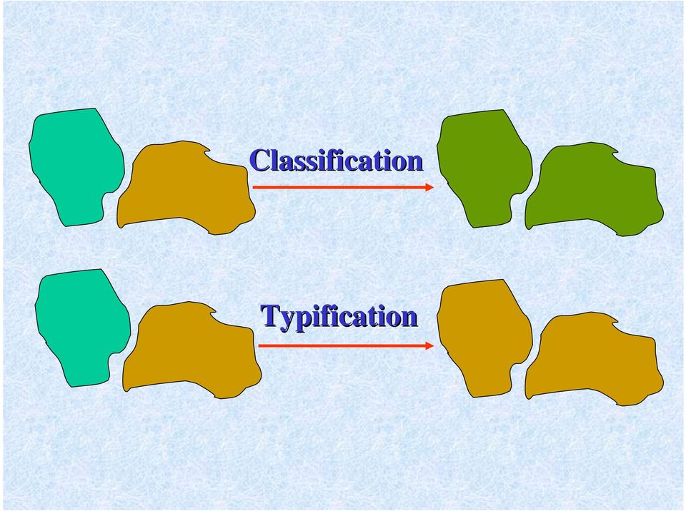
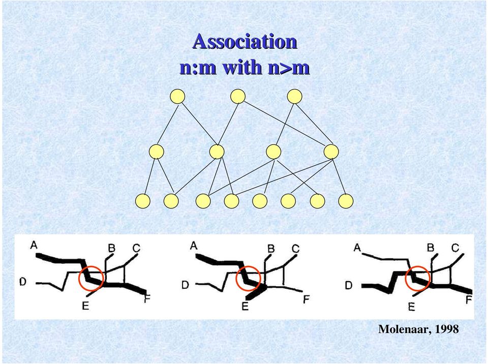
10 Operations of Model Generalization Selection / Elimination Dimensional Shift Classification / Typification Line Simplification Area Amalgamation Aggregation Association

11 Hole after elimination Skeleton (Bader & Weibel, 1997) Area allocation Before and after elimination Filling based on mode principle (Schylberg, 1993)

12 Classification Typification
13 Line Simplification Original geometry Self intersection Simplified line Original geometry Topological conflict with neighboring obj. Simplified line

14 Amalgamation of Area Objects

15 Aggregation Settlement Vegetation Water Township or village Objects of the same class Objects of different classes Objects of the same geometry type Objects of different geometry types

16 Hierarchical aggregation n:1 Functional aggregation n:m with n>m

17 Association n:m with n>m Molenaar, 1998
18 Execution Sequences of Generation Operations Original Data Amalgamation Selection /Elimination Original data Classification Amalgamation ation /Typification

19 Derivation of Quantitative Measures arithmetic, statistic, fuzzy Definition of Local Constraints and Rules calling sequence, parameters, iteration degree, control points, identity from multi-identity, identity, rules -> > algorithms, rules -> > conditions + actions Enrichment of Algorithms applicability, side effects, valid range of a parameter, computer intensity, converging speed, equivalent method, missing method, integration in data

20 L1 L2 F1 L3 Rule based treatment of the object L2 with double identity Partitioning an object into homogeneous parts based on fractal analysis

21 Strategies for Quality Control The best possible solution through enrichment of tools and data An acceptable solution without enrichment of tools and data An acceptable solution through enrichment of tools and data
22 Operations of Map Design Visible / Hidden Symbolization / Typification Smoothing Exaggeration Displacement Text placement Layout design
23 Map as Interface between System User and Model DLM On-demand Visualization DTK Geometry Appearance Topographic Objects
AdV Project: Map Production of DTK50 and DTK100 by Using Generalisation Processes
 Geoinformation und Landentwicklung AdV Project: Map Production of DTK50 and DTK100 by Using Generalisation Processes Sabine Urbanke, LGL Baden-Württemberg AdV- Project: The AAA Data Model Geodetic reference
DATA VISUALIZATION GABRIEL PARODI STUDY MATERIAL: PRINCIPLES OF GEOGRAPHIC INFORMATION SYSTEMS AN INTRODUCTORY TEXTBOOK CHAPTER 7
 DATA VISUALIZATION GABRIEL PARODI STUDY MATERIAL: PRINCIPLES OF GEOGRAPHIC INFORMATION SYSTEMS AN INTRODUCTORY TEXTBOOK CHAPTER 7 Contents GIS and maps The visualization process Visualization and strategies
MRDB APPROACH TO HANDLE AND VISUALISE MULTIPLE DLM S IN A CONSISTENT WAY
 MRDB APPROACH TO HANDLE AND VISUALISE MULTIPLE DLM S IN A CONSISTENT WAY K.-H. Anders a, *, I.Ö. Bildirici b a Institute for Cartography and Geoinformatics, University of Hannover, Germany Karl-Heinrich.Anders@ikg.uni-hannover.de
Everyday Mathematics. Grade 4 Grade-Level Goals CCSS EDITION. Content Strand: Number and Numeration. Program Goal Content Thread Grade-Level Goal
 Content Strand: Number and Numeration Understand the Meanings, Uses, and Representations of Numbers Understand Equivalent Names for Numbers Understand Common Numerical Relations Place value and notation
ARTIFICIAL INTELLIGENCE METHODS IN EARLY MANUFACTURING TIME ESTIMATION
 1 ARTIFICIAL INTELLIGENCE METHODS IN EARLY MANUFACTURING TIME ESTIMATION B. Mikó PhD, Z-Form Tool Manufacturing and Application Ltd H-1082. Budapest, Asztalos S. u 4. Tel: (1) 477 1016, e-mail: miko@manuf.bme.hu
What is Visualization? Information Visualization An Overview. Information Visualization. Definitions
 What is Visualization? Information Visualization An Overview Jonathan I. Maletic, Ph.D. Computer Science Kent State University Visualize/Visualization: To form a mental image or vision of [some
Pro/ENGINEER Wildfire 4.0 Basic Design
 Introduction Datum features are non-solid features used during the construction of other features. The most common datum features include planes, axes, coordinate systems, and curves. Datum features do
PROGRESSIVE TRANSMISSION AND VISUALIZATION OF VECTOR DATA OVER WEB INTRODUCTION
 PROGRESSIVE TRANSMISSION AND VISUALIZATION OF VECTOR DATA OVER WEB Tinghua Ai and Jingzhong Li School of Resource and Environment Sciences Wuhan University, China ABSTRACT The progressive transmission
MAP GENERALIZATION FOR OSMASTERMAP DATA IN LOCATION BASED SERVICES & MOBILE GIS APPLICATIONS
 Geoinformatics 2004 Proc. 12th Int. Conf. on Geoinformatics Geospatial Information Research: Bridging the Pacific and Atlantic University of Gävle, Sweden, 7-9 June 2004 MAP GENERALIZATION FOR OSMASTERMAP
Monash University Clayton s School of Information Technology CSE3313 Computer Graphics Sample Exam Questions 2007
 Monash University Clayton s School of Information Technology CSE3313 Computer Graphics Questions 2007 INSTRUCTIONS: Answer all questions. Spend approximately 1 minute per mark. Question 1 30 Marks Total
The automatic generalization of buildings whilst maintaining the settlement structure. A case study based on the 1:50`000 Swiss National Map Series
 The automatic generalization of buildings whilst maintaining the settlement structure A case study based on the 1:50`000 Swiss National Map Series Anna Vetter 05.12.2014 The Structure 1. Introduction 2.
Weld Design. CATIA V5 Training Foils. Weld Design. Copyright DASSAULT SYSTEMES 1. Instructor Notes:
 CATIA V5 Training Foils Weld Design Version 5 Release 19 January 2009 EDU_CAT_EN_WD1_FI_V5R19 1 About this course Objectives of the course Upon completion of this course you will be able to: - Weld parts,
An Open Framework for Reverse Engineering Graph Data Visualization. Alexandru C. Telea Eindhoven University of Technology The Netherlands.
 An Open Framework for Reverse Engineering Graph Data Visualization Alexandru C. Telea Eindhoven University of Technology The Netherlands Overview Reverse engineering (RE) overview Limitations of current
Everyday Mathematics. Grade 4 Grade-Level Goals. 3rd Edition. Content Strand: Number and Numeration. Program Goal Content Thread Grade-Level Goals
 Content Strand: Number and Numeration Understand the Meanings, Uses, and Representations of Numbers Understand Equivalent Names for Numbers Understand Common Numerical Relations Place value and notation
CATIA V5R21 - FACT SHEET
 CATIA V5R21 - FACT SHEET Introduction What s New at a Glance Overview Detailed Description INTRODUCTION CATIA V5 is the leading solution for product success. It addresses all manufacturing organizations;
AFM Ch.12 - Practice Test
 AFM Ch.2 - Practice Test Multiple Choice Identify the choice that best completes the statement or answers the question.. Form a sequence that has two arithmetic means between 3 and 89. a. 3, 33, 43, 89
Lesson 15 - Fill Cells Plugin
 15.1 Lesson 15 - Fill Cells Plugin This lesson presents the functionalities of the Fill Cells plugin. Fill Cells plugin allows the calculation of attribute values of tables associated with cell type layers.
SDMX technical standards Data validation and other major enhancements
 SDMX technical standards Data validation and other major enhancements Vincenzo Del Vecchio - Bank of Italy 1 Statistical Data and Metadata exchange Original scope: the exchange Statistical Institutions
Digital Cadastral Maps in Land Information Systems
 LIBER QUARTERLY, ISSN 1435-5205 LIBER 1999. All rights reserved K.G. Saur, Munich. Printed in Germany Digital Cadastral Maps in Land Information Systems by PIOTR CICHOCINSKI ABSTRACT This paper presents
Design Compiler Graphical Create a Better Starting Point for Faster Physical Implementation
 Datasheet Create a Better Starting Point for Faster Physical Implementation Overview Continuing the trend of delivering innovative synthesis technology, Design Compiler Graphical delivers superior quality
Data Mining: Concepts and Techniques. Jiawei Han. Micheline Kamber. Simon Fräser University К MORGAN KAUFMANN PUBLISHERS. AN IMPRINT OF Elsevier
 Data Mining: Concepts and Techniques Jiawei Han Micheline Kamber Simon Fräser University К MORGAN KAUFMANN PUBLISHERS AN IMPRINT OF Elsevier Contents Foreword Preface xix vii Chapter I Introduction I I.
AUTOMATED CONSTRUCTION PLANNING FOR MULTI-STORY BUILDINGS
 AUTOMATED CONSTRUCTION PLANNING FOR MULTI-STORY BUILDINGS Tang-Hung Nguyen 1 ABSTRACT This paper outlines a computer-based framework that can assist construction planners and schedulers in automatically
Quality Assessment in the framework of Map Generalization
 1/22/2015 1 Quality Assessment in the framework of Map Generalization Lysandros Tsoulos - Natalia Blana NATIONAL TECHNICAL UNIVERSITY OF ATHENS 1/22/2015 2 Contents Introduction Components of Map/Chart
REPRESENTATION OF SKETCH DATA FOR LOCALISATION IN LARGE DATA SETS
 REPRESENTATION OF SKETCH DATA FOR LOCALISATION IN LARGE DATA SETS M. Kopczynski, M. Sester Institute of Cartography and Geoinformatics, University of Hannover, Appelstraße 9a, 30167 Hannover, Germany Matthias.Kopczynski@ikg.uni-hannover.de
Advanced spatial discretizations in the B2.5 plasma fluid code
 Advanced spatial discretizations in the B2.5 plasma fluid code Klingshirn, H.-J. a,, Coster, D.P. a, Bonnin, X. b, a Max-Planck-Institut für Plasmaphysik, EURATOM Association, Garching, Germany b LSPM-CNRS,
SCALABILITY OF CONTEXTUAL GENERALIZATION PROCESSING USING PARTITIONING AND PARALLELIZATION. Marc-Olivier Briat, Jean-Luc Monnot, Edith M.
 SCALABILITY OF CONTEXTUAL GENERALIZATION PROCESSING USING PARTITIONING AND PARALLELIZATION Abstract Marc-Olivier Briat, Jean-Luc Monnot, Edith M. Punt Esri, Redlands, California, USA mbriat@esri.com, jmonnot@esri.com,
Practical Applications of DATA MINING. Sang C Suh Texas A&M University Commerce JONES & BARTLETT LEARNING
 Practical Applications of DATA MINING Sang C Suh Texas A&M University Commerce r 3 JONES & BARTLETT LEARNING Contents Preface xi Foreword by Murat M.Tanik xvii Foreword by John Kocur xix Chapter 1 Introduction
Review of Modern Techniques of Qualitative Data Clustering
 Review of Modern Techniques of Qualitative Data Clustering Sergey Cherevko and Andrey Malikov The North Caucasus Federal University, Institute of Information Technology and Telecommunications cherevkosa92@gmail.com,
Visibility optimization for data visualization: A Survey of Issues and Techniques
 Visibility optimization for data visualization: A Survey of Issues and Techniques Ch Harika, Dr.Supreethi K.P Student, M.Tech, Assistant Professor College of Engineering, Jawaharlal Nehru Technological
Content of Variable-scale Maps
 Content of Variable-scale Maps PhD Research Proposal Radan Šuba, MSc GISt Report No. 64 January 2013 Content of Variable-scale Maps PhD Research Proposal Radan Šuba, MSc GISt Report No. 64 January 2013
Identification algorithms for hybrid systems
 Identification algorithms for hybrid systems Giancarlo Ferrari-Trecate Modeling paradigms Chemistry White box Thermodynamics System Mechanics... Drawbacks: Parameter values of components must be known
Rank one SVD: un algorithm pour la visualisation d une matrice non négative
 Rank one SVD: un algorithm pour la visualisation d une matrice non négative L. Labiod and M. Nadif LIPADE - Universite ParisDescartes, France ECAIS 2013 November 7, 2013 Outline Outline 1 Data visualization
Representing Geography
 3 Representing Geography OVERVIEW This chapter introduces the concept of representation, or the construction of a digital model of some aspect of the Earth s surface. The geographic world is extremely
Designing a Schematic and Layout in PCB Artist
 Designing a Schematic and Layout in PCB Artist Application Note Max Cooper March 28 th, 2014 ECE 480 Abstract PCB Artist is a free software package that allows users to design and layout a printed circuit
Introduction to Computer Graphics
 Introduction to Computer Graphics Torsten Möller TASC 8021 778-782-2215 torsten@sfu.ca www.cs.sfu.ca/~torsten Today What is computer graphics? Contents of this course Syllabus Overview of course topics
Reading Questions. Lo and Yeung, 2007: 2 19. Schuurman, 2004: Chapter 1. 1. What distinguishes data from information? How are data represented?
 Reading Questions Week two Lo and Yeung, 2007: 2 19. Schuurman, 2004: Chapter 1. 1. What distinguishes data from information? How are data represented? 2. What sort of problems are GIS designed to solve?
Visualization methods for patent data
 Visualization methods for patent data Treparel 2013 Dr. Anton Heijs (CTO & Founder) Delft, The Netherlands Introduction Treparel can provide advanced visualizations for patent data. This document describes
COUNTY OF LOS ANGELES CHIEF INFORMATION OFFICE 500 West Temple Street 493 Kenneth Hahn Hall of Administration Los Angeles, CA 90012
 COUNTY OF LOS ANGELES CHIEF INFORMATION OFFICE 500 West Temple Street 493 Kenneth Hahn Hall of Administration Los Angeles, CA 90012 RICHARD SANCHEZ ACTING CHIEF INFORMATION OFFICER Telephone: (213) 974-2008
J48 Algebra And Spatial Data Mining - Models
 SEMANTIC DATA INTEGRATION ACROSS DIFFERENT SCALES: AUTOMATIC LEARNING OF GENERALIZATION RULES Birgit Kieler Institute of Cartography and Geoinformatics, Leibniz University of Hannover, Germany birgit.kieler@ikg.uni-hannover.de
SPATIAL ANALYSIS IN GEOGRAPHICAL INFORMATION SYSTEMS. A DATA MODEL ORffiNTED APPROACH
 POSTER SESSIONS 247 SPATIAL ANALYSIS IN GEOGRAPHICAL INFORMATION SYSTEMS. A DATA MODEL ORffiNTED APPROACH Kirsi Artimo Helsinki University of Technology Department of Surveying Otakaari 1.02150 Espoo,
REAL-TIME DATA GENERALISATION AND INTEGRATION USING JAVA
 REAL-TIME DATA GENERALISATION AND INTEGRATION USING JAVA Lars Harrie and Mikael Johansson National Land Survey of Sweden SE-801 82 Gävle lars.harrie@lantm.lth.se, micke.j@goteborg.utfors.se KEY WORDS:
Database Management. A Handbook on Database Management
 Database Management A Handbook on Database Management Database Management Attribute Data Entering and Coding Attribute data Linking Digital Map and Attribute Information Database and Database Management
TABLE OF CONTENTS. INTRODUCTION... 5 Advance Concrete... 5 Where to find information?... 6 INSTALLATION... 7 STARTING ADVANCE CONCRETE...
 Starting Guide TABLE OF CONTENTS INTRODUCTION... 5 Advance Concrete... 5 Where to find information?... 6 INSTALLATION... 7 STARTING ADVANCE CONCRETE... 7 ADVANCE CONCRETE USER INTERFACE... 7 Other important
Automatic Structure Detection and Generalization of Railway Networks
 Automatic Structure Detection and Generalization of Railway Networks Sandro Savino*, Guillaume Touya** * Department of Information Engineering, University of Padova, Italy ** COGIT IGN France, 73 avenue
Lecture 9: Geometric map transformations. Cartographic Transformations
 Cartographic Transformations Analytical and Computer Cartography Lecture 9: Geometric Map Transformations Attribute Data (e.g. classification) Locational properties (e.g. projection) Graphics (e.g. symbolization)
Bachelor's Degree in Business Administration and Master's Degree course description
 Bachelor's Degree in Business Administration and Master's Degree course description Bachelor's Degree in Business Administration Department s Compulsory Requirements Course Description (402102) Principles
Segmentation of building models from dense 3D point-clouds
 Segmentation of building models from dense 3D point-clouds Joachim Bauer, Konrad Karner, Konrad Schindler, Andreas Klaus, Christopher Zach VRVis Research Center for Virtual Reality and Visualization, Institute
CAD and Creativity. Contents
 CAD and Creativity K C Hui Department of Automation and Computer- Aided Engineering Contents Various aspects of CAD CAD training in the university and the industry Conveying fundamental concepts in CAD
Consumption of OData Services of Open Items Analytics Dashboard using SAP Predictive Analysis
 Consumption of OData Services of Open Items Analytics Dashboard using SAP Predictive Analysis (Version 1.17) For validation Document version 0.1 7/7/2014 Contents What is SAP Predictive Analytics?... 3
Extracting Business. Value From CAD. Model Data. Transformation. Sreeram Bhaskara The Boeing Company. Sridhar Natarajan Tata Consultancy Services Ltd.
 Extracting Business Value From CAD Model Data Transformation Sreeram Bhaskara The Boeing Company Sridhar Natarajan Tata Consultancy Services Ltd. GPDIS_2014.ppt 1 Contents Data in CAD Models Data Structures
Monitoring of Complex Industrial Processes based on Self-Organizing Maps and Watershed Transformations
 Monitoring of Complex Industrial Processes based on Self-Organizing Maps and Watershed Transformations Christian W. Frey 2012 Monitoring of Complex Industrial Processes based on Self-Organizing Maps and
Teacher Professional Development in the Teaching and Learning of Functions
 Teacher Professional Development in the Teaching and Learning of Functions Teacher professional development occurs both during the initial preparation of prospective teachers and for experienced teachers.
 System Modelingg Models of Computation and their Applications Axel Jantsch Laboratory for Electronics and Computer Systems (LECS) Royal Institute of Technology, Stockholm, Sweden February 4, 2005 System
Knowledge Discovery and Data Mining. Structured vs. Non-Structured Data
 Knowledge Discovery and Data Mining Unit # 2 1 Structured vs. Non-Structured Data Most business databases contain structured data consisting of well-defined fields with numeric or alphanumeric values.
TABLE OF CONTENTS ABSTRACT ACKNOWLEDGEMENT LIST OF FIGURES LIST OF TABLES
 TABLE OF CONTENTS ABSTRACT ACKNOWLEDGEMENT LIST OF FIGURES LIST OF TABLES ii iii x xiv CHAPTER 1: INTRODUCTION 1 1.0 Background 1 1.1 Research Motivation 4 1.2 Research Objectives 5 1.3 Project Scope 6
Visualisatie BMT. Introduction, visualization, visualization pipeline. Arjan Kok Huub van de Wetering (h.v.d.wetering@tue.nl)
") Visualisatie BMT Introduction, visualization, visualization pipeline Arjan Kok Huub van de Wetering (h.v.d.wetering@tue.nl) 1 Lecture overview Goal Summary Study material What is visualization Examples
Visualisatie BMT Introduction, visualization, visualization pipeline Arjan Kok Huub van de Wetering (h.v.d.wetering@tue.nl) 1 Lecture overview Goal Summary Study material What is visualization Examples
Optical Illusions Essay Angela Wall EMAT 6690
 Optical Illusions Essay Angela Wall EMAT 6690! Optical illusions are images that are visually perceived differently than how they actually appear in reality. These images can be very entertaining, but
VISUALIZATION STRATEGIES AND TECHNIQUES FOR HIGH-DIMENSIONAL SPATIO- TEMPORAL DATA
 VISUALIZATION STRATEGIES AND TECHNIQUES FOR HIGH-DIMENSIONAL SPATIO- TEMPORAL DATA Summary B. Schmidt, U. Streit and Chr. Uhlenküken University of Münster Institute of Geoinformatics Robert-Koch-Str. 28
Recovering Business Rules from Legacy Source Code for System Modernization
 Recovering Business Rules from Legacy Source Code for System Modernization Erik Putrycz, Ph.D. Anatol W. Kark Software Engineering Group National Research Council, Canada Introduction Legacy software 000009*
EFFICIENT DATA PRE-PROCESSING FOR DATA MINING
 EFFICIENT DATA PRE-PROCESSING FOR DATA MINING USING NEURAL NETWORKS JothiKumar.R 1, Sivabalan.R.V 2 1 Research scholar, Noorul Islam University, Nagercoil, India Assistant Professor, Adhiparasakthi College
ATS Revit Family Creation Standards July 23 rd, 2012 Plumbing Fixtures: Faucets Version 1.0
 This document outlines the design standard Allied Technical Services uses in the creation of Revit families. This edition will feature faucets, more specifically, bathroom and kitchen faucets. It is important
Map-like Wikipedia Visualization. Pang Cheong Iao. Master of Science in Software Engineering
 Map-like Wikipedia Visualization by Pang Cheong Iao Master of Science in Software Engineering 2011 Faculty of Science and Technology University of Macau Map-like Wikipedia Visualization by Pang Cheong
1. OLAP is an acronym for a. Online Analytical Processing b. Online Analysis Process c. Online Arithmetic Processing d. Object Linking and Processing
 1. OLAP is an acronym for a. Online Analytical Processing b. Online Analysis Process c. Online Arithmetic Processing d. Object Linking and Processing 2. What is a Data warehouse a. A database application
SECONDARY STORAGE TERRAIN VISUALIZATION IN A CLIENT-SERVER ENVIRONMENT: A SURVEY
 SECONDARY STORAGE TERRAIN VISUALIZATION IN A CLIENT-SERVER ENVIRONMENT: A SURVEY Kai Xu and Xiaofang Zhou School of Information Technology and Electrical Engineering The University of Queensland, Brisbane,
Graduate Co-op Students Information Manual. Department of Computer Science. Faculty of Science. University of Regina
 Graduate Co-op Students Information Manual Department of Computer Science Faculty of Science University of Regina 2014 1 Table of Contents 1. Department Description..3 2. Program Requirements and Procedures
VALLIAMMAI ENGNIEERING COLLEGE SRM Nagar, Kattankulathur 603203.
 VALLIAMMAI ENGNIEERING COLLEGE SRM Nagar, Kattankulathur 603203. DEPARTMENT OF COMPUTER SCIENCE AND ENGINEERING Year & Semester : III Year, V Semester Section : CSE - 1 & 2 Subject Code : CS6504 Subject
How To Get A Computer Engineering Degree
 COMPUTER ENGINEERING GRADUTE PROGRAM FOR MASTER S DEGREE (With Thesis) PREPARATORY PROGRAM* COME 27 Advanced Object Oriented Programming 5 COME 21 Data Structures and Algorithms COME 22 COME 1 COME 1 COME
Regression Clustering
 Chapter 449 Introduction This algorithm provides for clustering in the multiple regression setting in which you have a dependent variable Y and one or more independent variables, the X s. The algorithm
Data Validation Online References
 Data Validation Online References Submitted To: Program Manager GeoConnections Victoria, BC, Canada Submitted By: Jody Garnett Brent Owens Refractions Research Inc. Suite 400, 1207 Douglas Street Victoria,
Data classification methods in GIS The most common methods
 University of Thessaly, Department of Planning and Regional Development Master Franco Hellenique POpulation, DEveloppement, PROspective Volos, 2013 Data classification methods in GIS The most common methods
MeshLab and Arc3D: Photo-Reconstruction and Processing of 3D meshes
 MeshLab and Arc3D: Photo-Reconstruction and Processing of 3D meshes P. Cignoni, M Corsini, M. Dellepiane, G. Ranzuglia, (Visual Computing Lab, ISTI - CNR, Italy) M. Vergauven, L. Van Gool (K.U.Leuven ESAT-PSI
Recent Advances in Periscope for Performance Analysis and Tuning
 Recent Advances in Periscope for Performance Analysis and Tuning Isaias Compres, Michael Firbach, Michael Gerndt Robert Mijakovic, Yury Oleynik, Ventsislav Petkov Technische Universität München Yury Oleynik,
Bentley ArcGIS. Connector
 Bentley ArcGIS Connector Introduction ESRI, as a GIS software products company, and Bentley Systems, Incorporated, as a developer of solutions for architecture/engineering/construction (AEC) professionals,
Benchmark Test Reveals Best CAD Tool for Assembly Performance
 Benchmark Test Reveals Best CAD Tool for Assembly Performance Speed is everything in product development, especially when it comes to creating and managing large assemblies. And while some 3D CAD vendors

MATH 0110 Developmental Math Skills Review, 1 Credit, 3 hours lab
 MATH 0110 Developmental Math Skills Review, 1 Credit, 3 hours lab MATH 0110 is established to accommodate students desiring non-course based remediation in developmental mathematics. This structure will
siemens.com/mobility Sitraffic Office The integrated workstation for traffic engineers
 siemens.com/mobility Sitraffic Office The integrated workstation for traffic engineers A single software system for use by the traffic engineer, the operator and the service technician? Welcome to the
Machine Learning and Data Analysis overview. Department of Cybernetics, Czech Technical University in Prague. http://ida.felk.cvut.
 Machine Learning and Data Analysis overview Jiří Kléma Department of Cybernetics, Czech Technical University in Prague http://ida.felk.cvut.cz psyllabus Lecture Lecturer Content 1. J. Kléma Introduction,
Improving Data Mining of Multi-dimension Objects Using a Hybrid Database and Visualization System
 Improving Data Mining of Multi-dimension Objects Using a Hybrid Database and Visualization System Yan Xia, Anthony Tung Shuen Ho School of Electrical and Electronic Engineering Nanyang Technological University,
Spatial Data Mining Methods and Problems
 Spatial Data Mining Methods and Problems Abstract Use summarizing method,characteristics of each spatial data mining and spatial data mining method applied in GIS,Pointed out that the space limitations
Oracle8i Spatial: Experiences with Extensible Databases
 Oracle8i Spatial: Experiences with Extensible Databases Siva Ravada and Jayant Sharma Spatial Products Division Oracle Corporation One Oracle Drive Nashua NH-03062 {sravada,jsharma}@us.oracle.com 1 Introduction
The Visualization Pipeline
 The Visualization Pipeline Conceptual perspective Implementation considerations Algorithms used in the visualization Structure of the visualization applications Contents The focus is on presenting the
DETECTION OF URBAN FEATURES AND MAP UPDATING FROM SATELLITE IMAGES USING OBJECT-BASED IMAGE CLASSIFICATION METHODS AND INTEGRATION TO GIS
 Proceedings of the 4th GEOBIA, May 79, 2012 Rio de Janeiro Brazil. p.315 DETECTION OF URBAN FEATURES AND MAP UPDATING FROM SATELLITE IMAGES USING OBJECTBASED IMAGE CLASSIFICATION METHODS AND INTEGRATION
University of Arkansas Libraries ArcGIS Desktop Tutorial. Section 2: Manipulating Display Parameters in ArcMap. Symbolizing Features and Rasters:
 : Manipulating Display Parameters in ArcMap Symbolizing Features and Rasters: Data sets that are added to ArcMap a default symbology. The user can change the default symbology for their features (point,
Visualization Techniques in Data Mining
 Tecniche di Apprendimento Automatico per Applicazioni di Data Mining Visualization Techniques in Data Mining Prof. Pier Luca Lanzi Laurea in Ingegneria Informatica Politecnico di Milano Polo di Milano
INTEGRATION OF SPATIAL DATA WITHIN A GENERIC PLATFORM FOR LOCATION-BASED APPLICATIONS
 ISPRS SIPT IGU UCI CIG ACSG Table of contents Table des matières Authors index Index des auteurs Search Recherches Exit Sortir INTEGRATION OF SPATIAL DATA WITHIN A GENERIC PLATFORM FOR LOCATION-BASED APPLICATIONS
Interactive Data Mining and Visualization
 Interactive Data Mining and Visualization Zhitao Qiu Abstract: Interactive analysis introduces dynamic changes in Visualization. On another hand, advanced visualization can provide different perspectives
A Collaborative Approach to Building Personal Knowledge Networks or How to Build a Knowledge Advantage Machine?
 A Collaborative Approach to Building Personal Knowledge Networks or How to Build a Knowledge Advantage Machine? Ramana Reddy SIP Lab, CSEE, West Virginia University Morgantown, WV, USA Ramana.Reddy@mail.wvu.edu
Data Warehousing and Data Mining in Business Applications
 133 Data Warehousing and Data Mining in Business Applications Eesha Goel CSE Deptt. GZS-PTU Campus, Bathinda. Abstract Information technology is now required in all aspect of our lives that helps in business
A Short Introduction to Computer Graphics
 A Short Introduction to Computer Graphics Frédo Durand MIT Laboratory for Computer Science 1 Introduction Chapter I: Basics Although computer graphics is a vast field that encompasses almost any graphical
Understand the Sketcher workbench of CATIA V5.
 Chapter 1 Drawing Sketches in Learning Objectives the Sketcher Workbench-I After completing this chapter you will be able to: Understand the Sketcher workbench of CATIA V5. Start a new file in the Part
Visualizing changes in a dynamic Voronoi data structure via time travel
 Visualizing changes in a dynamic Voronoi data structure via time travel Darka Mioc, François Anton & Christopher Gold Industrial Chair of Geomatics, Université Laval 0722 Pavillon Casault, CRG Sainte-Foy,
Parallel Simplification of Large Meshes on PC Clusters
 Parallel Simplification of Large Meshes on PC Clusters Hua Xiong, Xiaohong Jiang, Yaping Zhang, Jiaoying Shi State Key Lab of CAD&CG, College of Computer Science Zhejiang University Hangzhou, China April
Constrained Tetrahedral Mesh Generation of Human Organs on Segmented Volume *
 Constrained Tetrahedral Mesh Generation of Human Organs on Segmented Volume * Xiaosong Yang 1, Pheng Ann Heng 2, Zesheng Tang 3 1 Department of Computer Science and Technology, Tsinghua University, Beijing
The Workflow Management Coalition Specification Workflow Management Coalition Terminology & Glossary
 The Workflow Management Coalition Specification Workflow Management Coalition Terminology & Glossary Workflow The automation of a business process, in whole or part, during which documents, information
10 Generalising spatial data and dealing with multiple representations
 10 Generalising spatial data and dealing with multiple representations R WEIBEL AND G DUTTON Functions for generalising spatial data are of fundamental importance in GIS because of a variety of requirements
Everyday Mathematics CCSS EDITION CCSS EDITION. Content Strand: Number and Numeration
 CCSS EDITION Overview of -6 Grade-Level Goals CCSS EDITION Content Strand: Number and Numeration Program Goal: Understand the Meanings, Uses, and Representations of Numbers Content Thread: Rote Counting
NCGIA. National Center for Geographic Information and Analysis. Report of the ICA Workshop on Map Generalization
 NCGIA National Center for Geographic Information and Analysis Report of the ICA Workshop on Map Generalization G vle, Sweden 19-21 June 1997 by W.A. Mackaness, University of Edinburgh R. Weibel, University
NNMi120 Network Node Manager i Software 9.x Essentials
 NNMi120 Network Node Manager i Software 9.x Essentials Instructor-Led Training For versions 9.0 9.2 OVERVIEW This course is designed for those Network and/or System administrators tasked with the installation,
Models of Cortical Maps II
 CN510: Principles and Methods of Cognitive and Neural Modeling Models of Cortical Maps II Lecture 19 Instructor: Anatoli Gorchetchnikov dy dt The Network of Grossberg (1976) Ay B y f (