Zion National Park Mystery Canyon
|
|
|
- Brenda Paul
- 3 years ago
- Views:
From this document you will learn the answers to the following questions:
What type offall creates a seasonal lake?
What can be approached from the Weeping Rock shuttle stop?
What can you use to get to the edge of Mystery Canyon?
Transcription
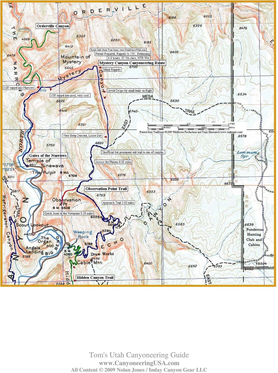
1 Zion National Park Mystery Canyon Mystery is my favorite Zion canyon. Oh my heck, it has everything a rough-tough smackdown approach; a verdant, wooded canyon with spectacular soaring walls; multiple rappels through intimate, sculpted narrows; some walking in the hot sun; a monstrous rockfall that creates a seasonal lake; a big rappel into a pool; wading pools in a jungle paradise; and finally a slippery slab rappel to the whirring camcorders of numerous tourists. Not too long, not too short - Mystery is a great outing. Mystery can be approached from either the Weeping Rock shuttle stop in the main canyon or from the East Mesa trailhead on the Zion Ponderosa Ranch. The second option saves you 2100 feet (640m) of climbing on a steep trail, but requires a car shuttle. Mystery is a popular canyon, and permits can be hard to get. Expect to share the canyon with other parties, especially on weekends. Rating: 3B III Time Required: 5 to 8 hours Preferred Season: Summer or fall. Cold Water Protection: Wetsuits recommended in spring and fall. Longest Rappel: 120 feet (38 m) Special Difficulties: None Gear and Difficulties: Mystery has about 12 rappels up to 120 feet (40m) in length. Bring feet of webbing and some rapid links in case slings are missing or damaged. Bring drybags or dry kegs for your gear there can be two mandatory swims near the end. The swims are short, so wetsuits are not required if the weather is hot and the lake is dry. In the spring and fall, wetsuits are recommended. Mystery does have an exposed traverse that most parties will want to protect using a safety/zip line or a belay. Each member of the party will need a tether and locking carabiner to clip the zip line. There is no drinking water in the canyon until the very end - bring your own. Finding the top of Mystery can be a problem, so bring a map and use it. I d like to think these directions alone are sufficient, but they are not. One or two parties a year start down the next drainage to the west (Miss-me), thinking they are in Mystery, and end up requiring a rescue. Make certain you are in the right place before heading down. If the approach does not look well traveled, you are in the wrong place go back! Getting There: From Zion Canyon/Weeping Rock: get an early start to avoid the heat. From Weeping Rock, ascend the Observation Point Trail. The trail switchbacks up the mountain below the face of Cable Mountain, then cuts left into Echo Canyon, briefly following the streambed before climbing up the side on a cutout and getting back into the sun. More climbing across mixed slickrock and brush leads to the base of a buttress. Climb steeply up the buttress, switchbacking to the rim of the mesa. The trail follows the rim west toward Observation Point. One-third mile from Observation Point, the East Mesa Trail comes in on the right this takes you to Mystery Canyon. Allow 2 hours to climb to the trail junction (2.7 miles (4.3 km), ascent of 2100 feet (640m)) most of which is in the full sun after mid-morning.

2 The stroll out to Observation Point (1/3 mile, 1/2 km) provides a dramatic view of Zion Canyon, and is well worth a 45-minute diversion, if not pressed for time. From the trail junction, follow the East Mesa Trail north then east through brush and ponderosa pines. After 20 minutes, and just after passing the trail s highpoint, a gorge can be seen through the brush to the left, starting about 30 feet (10m) from the East Mesa Trail. Numerous small trails lead to the rim follow them to the apex of Mystery Canyon. Getting There, Ponderosa Ranch Approach: The East Mesa Trail begins on the Park Boundary and is accessed through the Zion Ponderosa Ranch Resort. Allow an hour driving time from Springdale. From Springdale, take Route 9 up Pine Creek Canyon toward Mt Carmel Junction. From the East Entrance, continue 2.4 miles east, then turn Left (N) on the paved North Fork Road. Follow the winding road 5.1 miles to the Zion Ponderosa Ranch Resort - turn left into the Ranch. The following mileage points are given from the entrance. The dirt roads from here are rough and not well signed. Please be respectful of Ponderosa residents you encounter - afoot, on ATV, on horse or in cars. You are a guest on the Ranch. A few, but not all, of the turns are marked for "Observation Point". 0.0 miles: At the entrance, go straight (avoid going down to the main resort building to the left) past a residence. Pavement ends. 0.4 miles: Y - go Right. 0.7 miles: T - go Right for Observation Point (Twin Knolls Road). 1.5 miles: T - go Right. 2.3 miles: Fir Road crosses - go straight. Road gets worse. Stop here if the road is wet. 2.6 miles: Deeply rutted hill - this is the worst spot. Some 2WDs will want to park at the top of the hill miles: Big Pine in center of road, rough. Go Left around pine, then Right down the hill. 2.9 miles: Y - go Left for East Mesa Trailhead 3.0 miles: End of Road at Park Boundary: Parking lot. For those of you with GPS: UTM Nad83: mE mN The Trail: Stroll west on the wide, smooth trail winding between huge Ponderosa pines with many signs of recent fires. Reach the top of Mystery Canyon at 2.1 miles (3.4 km). Mystery can be seen on the right for some time continue on the trail until it starts uphill to go around the left side of a small knoll. At this point, follow small trails through the brush right 30 feet (10m) to the edge of the canyon. Canyon: make certain you are in the correct place at the very apex of Mystery Canyon. The canyon should plunge spectacularly below you, and extend straight north, with a series of mountains on the left all in a row. On the right, a steep, straight wall stretches north below a tree-

3 topped mesa. A small but distinct trail leads down and right across a steep shale slope. (The trail is about 50 feet (15m) east (right) of the very apex of the canyon). Carefully follow trails and gullies steeply down through the woods for about half an hour. Take it slowly and carefully. This section is known as The Death Gully. Mystery Canyon is popular, and is showing wear and tear from all our boots and sneakers. The Death Gully descends a natural erosion gully, and our passage does little to make it worse. In the next section of the canyon, several small drops are encountered. With a few exceptions, please descend these drops directly, rather than taking the eroding paths to the sides. By doing so, you minimize your impact on this wonderful canyon. The Death Gully ends at a short, steep downclimb. Descend carefully the boulders may be unstable. This used to be a short rappel, but a debris-slide in spring 2005 altered the bottom 2/3rds of the Death Gully. Six minutes downcanyon, a short, clean drop is encountered descend it directly. A few minutes further downcanyon, a short drop blocks the canyon. A shallow groove in the slab provides a surprisingly easy butt-slide descent. A rope can be used to sequence down all but the last member of the party, who can be spotted from below. Sequencing is a technique for moving a group down short drops, especially low-angle drops. One person (usually the best climber) anchors the rope off their harness and braces themselves as needed to provide an anchor. The others rappel off the anchorperson, then spot as she downclimbs the drop. It is wise to consider the sequence of rappelers - usually heavy persons are sent first, while the rest of the team clips in and backs up the anchorperson. Another 10 minutes downcanyon leads to another short drop, with a bolt anchor. Two minutes further, a small drop is passed by sequencing or rappelling. About five minutes further on, the canyon drops and is clogged with big logs. Downclimb the logs, then rappel from a bolt anchor at the end of the slot. About 10 minutes further downcanyon, the slot jogs left and enters a section of cool, sculpted narrows with numerous rappels from fixed anchors. This is the Rock Narrows, and the count of "real rappels" begins here.

4 R1: 45 feet (15m) down a chute. Walk 40 feet. R2: 30 feet (10m) down a chute. Slide down a short step. Walk about 50 feet (15m) downcanyon. A single, ancient bolt is positioned above a short, easy downclimb (8 feet (2.5m), 5.2). Twenty feet further downcanyon, downclimb a log to a two-bolt anchor. R3: 12 feet (4m) to the canyon floor. Walk 20 feet. R4: Rap to a pothole, then down a lower slab (50 feet (15m)). The canyon turns left and opens to the sun. Follow the slot 100 feet, including two short downclimbs, to a big log sticking vertically in the canyon. R5: Rap 30 feet (10m) off a 2-bolt anchor next to a big log (!). Walk 50 feet, then downclimb a V slot to a 2-bolt anchor at a chockstone. R6: Rap 40 feet (14m) down a slab to a pothole ledge. Walk 10 feet. Rappel off a single bolt (30 feet (10m)) or downclimb (5.6) to a round pothole. This is a good place for lunch - the next section of the canyon is in the full sun. Apply sunscreen. The canyon opens up, with the impressive face of the Mountain of Mystery to the right. This section of canyon is often very hot. Follow the canyon past a few short scrambling sections to a flat area and a giant ponderosa log. The flat area is the bed of a lake formed behind a giant landslide that crashed into the canyon sometime in the early 70 s (definitely before 1976). When the upper canyon flashes, sediment is brought down to the point where the canyon is blocked, then deposited to build a flat plain. This is what happened in Zion Canyon a couple thousand years ago, building a flat area from below Zion Lodge to the Temple of Sinawava. Ascend the sand pile that blocks the canyon. A trail can be found, starting at the left margin and climbing diagonally across to the rock on the right. Drop down the far side of the sand pile, then carefully traverse a sandy ledge on the right side of the canyon, and downclimb back into the bottom. Follow the canyon for a few minutes to the top of a steep slab blocking the canyon. R7: Rap 50 feet (15m) from bolts down a slab. Follow the watercourse as the canyon tightens up. A short drop is bypassed by hopping over a rock on the right and downclimbing a chimney. Another short drop is passed by climbing under a log (the log itself is very slippery). By now, the canyon is delightfully shaded and cool. A few shallow pools are tiptoed around, then a groove followed to some larger pools. Stemming around these pools leads to a slot and the slabs at the top of Mystery Springs. Carefully climb left a few feet, then down to the comfortable pothole ledge. This is a good place to gear up for the last section of the canyon, and secure all your gear in drybags or kegs.
")
5 This is the exciting rappel into Mystery Spring. The anchor is at the far end of the slab. A single bolt at the near end can be used to set up a safety line, or for belaying folks out to the rappel anchor. Getting to the anchor is only 3 rd class, but rather exposed. R8: Rappel 110 feet (33m) into the pool at the base of the wall. This is a bit tricky, because the rappeller must rap to the top of a boulder in the slot below, which is to the side of the fall line; then continue the rappel off the boulder, down a slippery slot and into the pool. There is a small chimney stance inches above the water where one can disconnect from the rope before swimming. (The winter of 2004/2005 washed a lot of sand into this pool, and it was only waist deep in Hopefully, it will be restored to a full swim within a few years). Also of note, there is an old bolt anchor in the pool behind the boulder in the slot. If someone does go down the back side of the boulder, there is an anchor available over there. When pulling the rope, be sure it does not fall onto the boulder in the slot and get stuck. As it comes free, give it a gentle tug so the end falls towards you. Note: if concerned about speed or ability, set up a guided rappel. By not having to make the top of the boulder or rappel the slippery slot below, those of lesser skill will move faster and easier through the rappel. A guided rappel can also be used to keep people out of the pool, but that s no fun. The guided rappel plus safety line requires three sections of rope. Downclimb a small cascade into a waist-deep pool. Further on, a boulder blocks the width of the canyon, creating a short drop with a turquoise pool below it. There are several ways to deal with the pool. A small tree 10 feet back from the edge allows for a rappel. The chimney to the right can be downclimbed (5.4), though it is a little tricky. This pool used to be a good jump, but floods in 2005 washed a lot of sand into the pool, and it is now too shallow to jump. Continue downcanyon, downclimbing a short waterfall. After a short walk through the jungle, you arrive at the final rappel down Mystery Falls into The Narrows. R9: Rappel 120 feet (36m) from bolts down the slippery cascade to the river. Many an expert canyoneer has been embarrassed on this rappel try not to be among them. This is a good place to provide a bottom-belay for all rappellers. The Narrows is followed downcanyon about a half-mile (800m) to a stone structure (The Veranda) at the end of the paved trail. Follow the Gateway to the Narrows Trail one mile (1.6 km) to the Temple of Sinawava shuttle stop.

6
p. 1 Our Adventure to Peek-a-boo and Spooky Slot Canyons Written by a city dweller with no backcountry experience
 p. 1 Our Adventure to Peek-a-boo and Spooky Slot Canyons Written by a city dweller with no backcountry experience p. 2 Members of the trip 1. 45 year-old male. Relatively athletic. Play ping-pong; can
Biner Blocks, Pull Cords, and All That Stuff by Tom Jones
 Biner Blocks, Pull Cords, and All That Stuff by Tom Jones A BLOCK is a way of attaching the rope to an anchor so it can be retrieved. The normal "climber" method of setting up a rappel is to thread the
Focus On You Photography TRT from Brockway Summit to Watson Lake
 Tahoe Rim Trail (TRT) From Hwy 267 (Brockway Summit) west to Watson Lake (Strong Intermediate Advanced) This trail is very demanding. It is almost 2100 ft. of climbing. The trail is up and down, up and
ZION NATIONAL PARK ITINERARY
 ZION NATIONAL PARK ITINERARY Day 1 Travel / Arrive / Check-in Lodging, Afternoon walk, dining, relax. There s so much natural beauty waiting to be discovered at Zion National Park, so check in to your
Benton MacKaye Trail - Section 2. Three Forks (FS 58) to GA. Highway 60. 11.4 miles
 to GA. Highway 60. 11.4 miles") General Benton MacKaye Trail - Section 2 Three Forks (FS 58) to GA. Highway 60 11.4 miles This is the longest and most remote section of the Benton MacKaye Trail (BMT) east of GA 5. It follows the Appalachian
General Benton MacKaye Trail - Section 2 Three Forks (FS 58) to GA. Highway 60 11.4 miles This is the longest and most remote section of the Benton MacKaye Trail (BMT) east of GA 5. It follows the Appalachian
Earth Science Landforms, Weathering, and Erosion Reading Comprehension. Landforms, Weathering, and Erosion
 Reading Comprehension Name 1 How many people have been to the Rocky Mountains or the Grand Canyon? When people go to visit these natural wonders, they may not realize that it took millions of years for
Kancamagus Highway Guide
 Kancamagus Highway Guide The Kancamagus Highway. Undoubtedly the most scenic route in Mountain Country, the Kancamagus (k?an-c?a-mä-g?us) Highway (Rt. 112) stretches from the Pemigewasset River at Lincoln
There are many ways of differentiating the activity and tweaking it to suit the needs of pupils, these notes outline some possible strategies:
 How the mystery works There are many ways of differentiating the activity and tweaking it to suit the needs of pupils, these notes outline some possible strategies: The cards (see below) should be copied,
Four Short Walks From the Mill
 Four Short Walks From the Mill With directions, duration and length of walk www.ratonera.com (0034) 958 339 560 There are steep sections on most of these walks so please wear boots or stout shoes. A stick
EMPLOYEE FALL PROTECTION
 EMPLOYEE FALL PROTECTION You can fall from any height and be seriously injured or killed. In the construction industry, as well as any other industry, when falls from heights happen, they are usually very
Sabino Canyon History
 History During the Great Depression of the 1930 s, the CCC (Civilian Conservation Corporation) and the WPA (Works Progress Administration) built the nine bridges that crossed Sabino Creek. They originally
Jackson Gulch Outlet Canal Rehabilitation Project
 Jackson Gulch Outlet Canal Rehabilitation Project Preliminary Budgetary Estimate for Rehabilitation February 2004 Prepared for the Mancos Water Conservancy District Jackson Gulch Reservoir 42888 County
WEATHERING, EROSION, AND DEPOSITION PRACTICE TEST. Which graph best shows the relative stream velocities across the stream from A to B?
 NAME DATE WEATHERING, EROSION, AND DEPOSITION PRACTICE TEST 1. The diagram below shows a meandering stream. Measurements of stream velocity were taken along straight line AB. Which graph best shows the
Margherita Peak, Mt. Stanley, 8 day trek
 RWENZORI TREKKING Margherita Peak, Mt. Stanley, 8 day trek This 8 day itinerary will take you deep into the Rwenzori Mountains to Margherita Peak, the tallest peak on Mt. Stanley and Africa s third highest
Floods are too much water on normally dry land. Rivers can flood after heavy rain has fallen over a long period of time. River flooding can last
 Floods are too much water on normally dry land. Rivers can flood after heavy rain has fallen over a long period of time. River flooding can last weeks or longer. River floods usually occur slowly enough
BACKPACKING TRIP DIFFICULTY SNAPSHOT
 BACKPACKING TRIP DIFFICULTY SNAPSHOT Of course these ratings are only an indicator of hike difficulty - every hike has its variables beyond elevation gain and distance including weather, experience/fitness,
High Harbour at Lake Burton 685 Camp Harbour Lane Clayton, GA 30525 www.camphighharbour.com
 Lake Burton Retreat Center Group Rental Information YMCA CAMP HIGH HARBOUR High Harbour at Lake Burton 685 Camp Harbour Lane Clayton, GA 30525 www.camphighharbour.com Facilities YMCA Camp High Harbour
ACCIDENT REPORT LIPTON, RJUKAN febrary 22. 2015
 ACCIDENT REPORT LIPTON, RJUKAN febrary 22. 2015 Head of safety commision NKF, Odd Magne Øgreid sikkerhet@klatring.no On February 22, 2015, a 33-year old Italian climber lost his life in an accident while
LIFE SCIENCE. Hoop House Construction for New Mexico: 12-ft. x 40-ft. Hoop House BRINGING TO YOUR HOME ECONOMICS COLLEGE OF AGRICULTURE AND
 Hoop House Construction for New Mexico: 12-ft. x 40-ft. Hoop House COLLEGE OF AGRICULTURE AND HOME ECONOMICS BRINGING SCIENCE TO YOUR LIFE Hoop House Construction for New Mexico: 12-ft. x 40-ft. Hoop House
NATURAL REGIONS OF KENTUCKY
 NATURAL WONDERS As you travel around Kentucky taking pictures, you are excited by what you see. Kentucky offers diverse and amazing sights. The Six Regions In the West, you see the Mississippi River, the
Date R. Mirshahi. Forces are all around us. Without forces, nothing can move and no work can be done.
 Name Date R. Mirshahi Forces and Movement: Balanced and Unbalanced Forces Forces are all around us. Without forces, nothing can move and no work can be done. There are different types of forces. Some forces
Rapid Changes in Earth s Surface
 TEKS investigate rapid changes in Earth s surface such as volcanic eruptions, earthquakes, and landslides Rapid Changes in Earth s Surface Constant Changes Earth s surface is constantly changing. Wind,
PUBLIC SPACE AND SAFETY REGULATIONS FOR THE PATH EL CAMINITO DEL REY
 PUBLIC SPACE AND SAFETY REGULATIONS FOR THE PATH EL CAMINITO DEL REY GENERAL REGULATIONS Regulations that are to be followed during public visit to the path El Caminito del Rey (The King s Little Pathway)
BUILDING WITH STONE AND EARTH
 BUILDING WITH STONE AND EARTH PART 1 Earth is a popular building material all over the world. It can be used by itself, but if there is stone available, then the two can be used together to make very good
Birling Gap to Beachy Head
 Birling Gap to Beachy Head A shorter, easier exploration of this iconic coastline, taking in two historic lighthouses and an optional descent to the stony beach below the cliffs Essential Facts Route distance:
Small Dam Hazard Assessment Inventory
 Small Dam Hazard Assessment Inventory What would happen if your dam were to fail? This is a question that most dam owners hope they will never have to answer. However it is a question you, as a responsible
www.traditionalmountaineering.org
 www.traditionalmountaineering.org LEARNING SNOW CLIMBING with Robert Speik OBJECTIVES: To learn the basics of snow travel and snow climbing using the mountaineering ice axe as an aid; respect for the dangers
Rescue Dynamics. Subject: RAPPEL SAFETY TECHNIQUES: Instructional Support. Version: 4.0 Technical Note
 Rescue Dynamics 5109-17A Avenue NW, Edmonton, AB T6L 1K5 780-461 - 5040 fax / voice Internet - www.compusmart.ab.ca/resqdyn/ or email: resqdyn@compusmart.ab.ca Subject: RAPPEL SAFETY TECHNIQUES: Instructional
BEGINNING TERRAIN PARK SKI INSTRUCTION
 BEGINNING TERRAIN PARK SKI INSTRUCTION By Chuck Roberts PSIA Certified Level III Alpine http://www.robertsski.com ccr@robertsski.com - 1 - Copyright 2004 Charles C. Roberts, Jr. All rights reserved. Printed
BRIDGES ARE relatively expensive but often are
 Chapter 10 Bridges Chapter 10 Bridges Bridg Bridges -- usually the best, but most expensive drainage crossing structure. Protect bridges against scour. BRIDGES ARE relatively expensive but often are the
CHAPTER 3A Environmental Guidelines for STREAM CROSSING BY ALL-TERRAIN VEHICLES
 GOVERNMENT OF NEWFOUNDLAND AND LABRADOR DEPARTMENT OF ENVIRONMENT AND LABOUR CHAPTER 3A Environmental Guidelines for STREAM CROSSING BY ALL-TERRAIN VEHICLES WATER RESOURCES MANAGEMENT DIVISION Water Investigations
Glacier Erosion Notes
 Name Date ES per Mr. Landsman Glacier Erosion Notes Erosion: the of weathered material. Glacier: A large mass of ice and snow that exists year-round and moves under the influence of. Evidence for Glacier
CHAPTER 5 OPEN CHANNEL HYDROLOGY
 5.4 Uniform Flow Calculations 5.4.1 Design Charts CHAPTER 5 OPEN CHANNEL HYDROLOGY Following is a discussion of the equations that can be used for the design and analysis of open channel flow. The Federal
Rimutaka Incline activity cards
 Rimutaka Incline activity cards To the supervisor As you lead your group on an exploration of the Rimutaka Incline, please ensure that the group stays together, treats the environment respectfully and
Optional Extension Trip Packages
 Optional Extension Trip Packages Make the most of that once in a lifetime opportunity These are your extension trip options and activities to add onto your Peru trip! Option 1 - Free Travel:- Day 9 - Day
Siting and settlement: The most important way to protect shelter from floods is to build in a place that is unlikely to be flooded.
 Siting and settlement: The most important way to protect shelter from floods is to build in a place that is unlikely to be flooded. Key Messages Shelters and settlements should be sited above the highest
FTC 2015-2016 DIY Mountain Build Guide
 FTC 2015-2016 DIY Mountain Build Guide Assembly Instructions Check out the DIY2015-2016 Prints and BoM for individual part details. Release 1.0 9/10/15 Page 1 This guide and Bill of Materials are for constructing
Deserts, Wind Erosion and Deposition
 Deserts, Wind Erosion and Deposition By definition, a desert has less than 10 in (25 cm) of precipitation per year. Deserts occur at 30 o and 60 o in regions of descending air. Deserts can be hot or cold.
Interpretive Elements
 Interpretive Elements The Rachel Carson Greenway will be an interpretive trail its entire length. The major interpretive themes relate to the natural world and the cultural and industrial history of the
How To Check For Scour At A Bridge
 Case Studies Bridge Scour Inspection and Repair Edward P. Foltyn, P.E. Senior Hydraulic Engineer ODOT Bridge Unit 2013 PNW Bridge Inspectors Conference April 2013 REFERENCES Stream Stability at Highway
Anchor Building on Multi-Pitch Climbs
 Anchor Building on Multi-Pitch Climbs Anchors are a crucial and important piece of the multi-pitch technical system but they are still only one piece. A well-built anchor alone cannot fully protect you
Igneous rocks formed when hot molten material (magma) cools and hardens (crystallizes).
 cools and hardens (crystallizes).") Objectives You will learn about how the land of North Dakota was formed. Introduction North Dakota is a wonderful place to live. Have you ever though about how it was formed? To answer that question, you
Objectives You will learn about how the land of North Dakota was formed. Introduction North Dakota is a wonderful place to live. Have you ever though about how it was formed? To answer that question, you
GM IFMGA 2013 in Huaraz Peru
 (AGMP) GM IFMGA 2013 in Huaraz Peru SUGGESTIONS FOR OPTIONAL PROGRAM IN THE REGION OF ANCASH PRIOR TO GENERAL MEETING (4 OR 6 DAYS) Two programs for the time between 9 th and 14 th October 2013 Coordinator
DESIGNING YOUR LANDSCAPE
 DESIGNING YOUR LANDSCAPE SITE AND NEEDS ASSESSMENT Examine all existing features of your site that could affect your landscape design and then identify the functions you want your landscape to serve. Site
BRITISH GEOLOGICAL SURVEY
 BRITISH GEOLOGICAL SURVEY RISK ASSESSMENT FOR WORKING IN QUARRIES Definitions from Health & Safety Executive anything that can cause harm. the chance that someone will be harmed by the hazard. Health and
Picnic Table Plans. Made out of a single sheet of plywood, it s also portable! By Kevin Ayer. This children's picnic table would
 Picnic Table Plans Made out of a single sheet of plywood, it s also portable! By Kevin Ayer Materials One 4- by 8-foot sheet of 3 4-inch AC plywood Twelve 11 4-inch wood screws Primer and exterior paint
5-Minute Refresher: WEATHERING AND EROSION
 5-Minute Refresher: WEATHERING AND EROSION Weathering and Erosion Key Ideas Weathering is the wearing away of the surface of rock, soil, and minerals into smaller pieces. Example of weathering: Wind and
The rock cycle. Introduction. What are rocks?
 The rock cycle This Revision looks at the three types of rock: sedimentary, igneous and metamorphic. It looks at how they are formed, the weathering of rocks and the way one form of rock turns into another,
Free-Form Concrete Pool
 The tranquil beauty and playful shimmer of a reflecting pool or fountain is just the thing to enhance the charm of your garden or patio. Best of all, you can do all the work yourself. Add goldfish or water
What are the specific demands of ultra running on trails and mountainous terrain?
 Guide to training for the Montane Lakeland 50 & 100 Many people entering ultra running events will already be accomplished long distance walkers and runners, whilst others may be less experienced. In this
The students will be working in and alongside the stream, so safety is a consideration. Suitable sites should have the following characteristics:
 Measuring Stream Banks: Height and Slope Stream bank heights and slopes are of interest because they yield information relevant to bank erosion and stability. A high, steep bank is likely to be unstable
Got ELK? Hunting Prices and Dates Also Current discounted pricing on Over the Counter Rifle seasons.
 Hunt ID: CO-ElkMDeerFishAll-Durango-DBARG-DIY Got ELK? We sure do too many Elk. So many we are offering a DIY drop camp hunt for a limited number of hunters in prime Southwestern Colorado Elk Country!
TIMARU BOYS & GIRLS HIGH SCHOOL Aviation Course
 TIMARU BOYS & GIRLS HIGH SCHOOL Aviation Course INTRODUCTION... AN AVIATION FLYING OPPORTUNITY Timaru Boys and Timaru Girls, in conjunction with South Canterbury Aero Club are very pleased to offer an
Chapter Two. Training by Wild Women On Top
 Chapter Two Training by Wild Women On Top Your decision to enter Coastrek will give you an opportunity to break down physical and mental barriers and achieve an extraordinary goal. Walking continuously
Homeowner s Guide to Drainage
 Homeowner s Guide to Drainage a scottsdale homeowner s guide to drainage produced by the city of scottsdale s stormwater management division Transportation Department TABLE OF CONTENTS Introduction 2 Drainage
Survival Skills for Canopy Control A Seminar by Performance Designs, Inc.
 Survival Skills for Canopy Control A Seminar by Performance Designs, Inc. I. Avoid landing accidents by doing all you can to eliminate landing off the DZ. As soon as you're open, evaluate the spot. When
The Ultimate Guide To Protecting Your House From Water In The Basement
 The Ultimate Guide To Protecting Your House From Water In The Basement Table of Contents 3 Causes of Water in the Basement!... 3 Reason Number 1: Poor Grading!... 3 Reason Number 2: Improper Drainage!...
How To Assess An Area For Erosion
 SKY BASIN (UPPER CA 1 WATERSHED) EROSION ASSESSMENT Prepared by Kevin Drake, CPESC Integrated Environmental Restoration Services, Inc. August 2014 COMMON GROUND UNCOMMON SOLUTIONS P.O. BOX 7559 2780 LAKE
9e) 100m past Dynevor Arms Pub go past lone bungalow on L then turn L along designated footpath. Emerge on main Rd (A469) turn L, then after 30m
 100m past Dynevor Arms Pub go past lone bungalow on L then turn L along designated footpath. Emerge on main Rd (A469) turn L, then after 30m") 9e) 100m past Dynevor Arms Pub go past lone bungalow on L then turn L along designated footpath. Emerge on main Rd (A469) turn L, then after 30m cross rd (CAREFUL) and head up obvious footpath opposite
9e) 100m past Dynevor Arms Pub go past lone bungalow on L then turn L along designated footpath. Emerge on main Rd (A469) turn L, then after 30m cross rd (CAREFUL) and head up obvious footpath opposite
Knots for Rock Climbers KNOT SELECTION AND CARE
 Knots for Rock Climbers - by Michael Strong - illustrations by Ryan Ojerio - KNOT SELECTION AND CARE The climber has a large selection of knots to chose from. While it may be tempting to learn as many
Guidelines for Durable Driveways, Carports Patios, Walks, Garage Floors
 Guidelines for Durable Driveways, Carports Patios, Walks, Garage Floors The Right Concrete Mix Placing and Finishing Joints Correctly Spaced Curing for Durability "Concrete durability is the ability to
PART2Machines. Measuring Work on a Cart on an. Inclined Plane 102. Inclined Plane 104. Inquiry 12.1 Using Pulleys To Do Work 112
 TERRY G. MCCREA/SMITHSONIAN INSTITUTION PART2Machines LESSON 11 The Inclined Plane 100 Inquiry 11.1 Inquiry 11.2 Measuring Forces on a Cart on an Inclined Plane 102 Measuring Work on a Cart on an Inclined
Your Defensible Space Slideshow
 Your Defensible Space Slideshow Red = Trees to Remove Your Defensible Space Slideshow This slideshow was created to highlight actions you can take to dramatically improve the chances of your home surviving
Hiking Guide Moosehead Lake Region. Difficulty: EASY
 Hiking Guide Moosehead Lake Region This region is blessed with some of the most spectacular hikes in the Northeast. A wide range of terrain will please both the casual stroller and the serious backpacker.
Design of Bridges. Introduction. 3 rd to 4 th July 2012. Lecture for SPIN Training at the University of Dar es Salaam
 Design of Bridges Introduction 3 rd to 4 th July 2012 1 FUNCTION OF A BRIDGE To connect two communities which are separated by streams, river, valley, or gorge, etc. 2 EVOLUTION OF BRIDGES 1. Log Bridge
Index. protection. excavated drop inlet protection (Temporary) 6.50.1 6.51.1. Block and gravel inlet Protection (Temporary) 6.52.1
 6.50.1 6.51.1. Block and gravel inlet Protection (Temporary) 6.52.1") 6 Index inlet protection excavated drop inlet protection (Temporary) 6.50.1 HARDWARE CLOTH AND GRAVEL INLET PROTECTION Block and gravel inlet Protection (Temporary) sod drop inlet protection ROCK DOUGHNUT
6 Index inlet protection excavated drop inlet protection (Temporary) 6.50.1 HARDWARE CLOTH AND GRAVEL INLET PROTECTION Block and gravel inlet Protection (Temporary) sod drop inlet protection ROCK DOUGHNUT
EXERCISE INSTRUCTIONS 1
 EXERCISE INSTRUCTIONS 1 Contents ANKLE TOUCHES... 4 BACK EXTENSIONS... 4 BACK REVERSE FLYES... 4 BALL ROLL... 4 BASKETBALL SQUATS... 4 BEAR CRAWL... 4 BICEP CURL (Resistance Band)... 4 BOXING JABS... 5
Thank you for downloading this tutorial! Before you get to work, please take the time to read the tutorial thoroughly.
 A Basic Knitted Beaded Amulet Bag Please note that this kit is for basic bead knitting, but it does not teach basic yarn knitting. It assumes you are comfortable with basic knitting, casting on and casting
Climate, Vegetation, and Landforms
 Climate, Vegetation, and Landforms Definitions Climate is the average weather of a place over many years Geographers discuss five broad types of climates Moderate, dry, tropical, continental, polar Vegetation:
TOWN OF HARRISBURG FIRE DEPARTMENT 6450 Morehead Road, Harrisburg North Carolina 28075 Phone: 704 455 3574 Fax 704 455 6391 www.harrisburgfd.
 FLOOD FACTS AND SAFETY TIPS Floods are one of the most common hazards in the United States. Flood effects can be local, impacting a neighborhood or community, or very large, affecting entire river basins
CADS INSTRUCTOR CERTIFICATION INFORMATION KIT
 CADS CADS INSTRUCTOR CERTIFICATION INFORMATION KIT GUIDELINES FOR CLINICS FIRST NIGHT (INTRODUCTION NIGHT) CONTENTS 1. EXPLANATION OF CADS (SEE INFORMATION BOOKLET) 2. MOVIE, SLIDES OR VIDEOS (EMPHASIS
The minimum reinforcement for the stem wall is the placement of:
 PolySteel creates an ideal insulated stem wall for concrete slabs that can make this part of your project easier and faster, in addition to making your finished project more energy-efficient. Figures 3.20
! Mera Peak Ski Expedition Nepal
 ! Mera Peak Ski Expedition Nepal October 17-November 6, 2016 $9,950 October 16-November 5, 2017 land costs (including internal heli and plane flights) Difficulty Level: Introductory Ski No technical climbing
Gear PEPSI CAN STOVE INSTRUCTIONS
 Gear PEPSI CAN STOVE INSTRUCTIONS [NOTE: Updated Instructions are now available. The new stove is less likely to develop flame leaks and the fuel/air mixture is improved. Instructions for a simmer ring
Flood After Fire Fact Sheet
 FACT SHEET Flood After Fire Fact Sheet Risks and Protection Floods are the most common and costly natural hazard in the nation. Whether caused by heavy rain, thunderstorms, or the tropical storms, the
Landslides & Mudslides
 Landslides & Mudslides Landslides, also known as mudslides and debris flow, occur in all U.S. states and territories. In snowy mountainous areas winter snow landslides are called avalanches. Landslides
LEAGUE NOTES ON APPROVED COMMUNITY WATER SUPPLY PLAN
 1 AUGUST 2011 LEAGUE NOTES ON APPROVED COMMUNITY WATER SUPPLY PLAN KEY ELEMENTS OF THE PLAN: 1. Replace the existing unsafe Ragged Mountain dam with a new dam and raise the reservoir pool level initially
Landslides. Landslides-1. March 2007
 Landslides Learn if landslides, including debris flows, could occur in your area by contacting local officials, your state geological survey or department of natural resources, or the geology department
Sand and Silt Removal from Salmonid Streams
 Sand and Silt Removal from Salmonid Streams Stream bank erosion Poor land use practices Sources of Sand and Silt Impacts of Sand and Silt Interstitial spaces infilled Little or no flow through the streambed
Prattsville Berm Removal Project. 1.0 Project Location
 Prattsville Berm Removal Project 1.0 Project Location The project site is located between the New York State Route 23 Bridge over the Schoharie Creek and the Schoharie Reservoir. The restoration plan encompassed
Fry Phrases Set 1. TeacherHelpForParents.com help for all areas of your child s education
 Set 1 The people Write it down By the water Who will make it? You and I What will they do? He called me. We had their dog. What did they say? When would you go? No way A number of people One or two How
Effects of Water Classroom Activity
 Effects of Water Classroom Activity The Classroom Activity introduces students to the context of a performance task, so they are not disadvantaged in demonstrating the skills the task intends to assess.
Gas Meter Clearances and Service Installation Requirements
 March 2016 Gas Meter Clearances and Service Installation Requirements Builder/Owner/Developer Requirements Call PSE's Customer Construction Services 1 888 321 7779 or visit PSE.com/CustomerConstruction
SUCCESSFUL FITTING AND GROOMING OF BEEF CATTLE Celina R. Johnson
 SUCCESSFUL FITTING AND GROOMING OF BEEF CATTLE Celina R. Johnson To be successful at fitting and grooming beef cattle for show requires hard work, dedication, and patience. Additionally, exhibitors must
A Guide to Accident Prevention on Motorcycles
 A Guide to Accident Prevention on Motorcycles SEE me now? Always ride with your dipped headlight on DAY AND NIGHT Avoiding the 5 most common motorcycle accidents... 1 Collisions at Junctions... These can
SOFTBALL GRADES 3-6 PAGE 1. Fill out before using! Run to the. Side slide to the. and back. and back.
 Fill out before using! Side slide to the Both in sit-up position, facing each other and feet touching. While you both do curl-ups toss a softball to each other while in the up position. Complete 20 Curl-ups.
Bridger Teton National Forest Backcountry Tracking SOP with Teton Interagency Dispatch Center
 Bridger Teton National Forest Backcountry Tracking SOP with Teton Interagency Dispatch Center I. PURPOSE: To establish a call-in and call-out procedure (backcountry tracking) for all Forest employees and
Geomorphology is the Study of Landforms. Usually by Erosion, Transportation and Deposition
 Geomorphology is the Study of Landforms and the Processes that t Create Them, Usually by Erosion, Transportation and Deposition Fluvial = running water, rivers and floodplains Glacial = flowing ice in
Types of Structures. Mass Structures. A Layered Look
 Types of Structures Have you ever made a sand castle or created a snow sculpture? What about building an igloo or assembling a tent? Perhaps you have woven a basket or baked a cake. All of these objects
How to erect a Kelty Grand Mesa 4 tent
 How to erect a Kelty Grand Mesa 4 tent Introduction When selecting a tent, one must first choose what purpose the tent will serve. There are many types of tents which serve a variety of purposes. These
International Specification for Ski Orienteering Maps ISSkiOM
 International Specification for Ski Orienteering Maps ISSkiOM Rev 12 February 2015 corrected mistake (PMS 345-> PMS 354), page 3 2014 Approved by IOF Ski Orienteering Commission, October 2014 Approved
INSTALLATION INSTRUCTIONS for Bifold Doors (JII103)
") Thank you for selecting JELD-WEN products. Attached are JELD-WEN s recommended installation instructions for premium composite, hollow and solid core molded Bifold Doors. Bifolds are designed for fast
Thank you for selecting JELD-WEN products. Attached are JELD-WEN s recommended installation instructions for premium composite, hollow and solid core molded Bifold Doors. Bifolds are designed for fast
Note: If organization is claiming non-profit status, documentation verifying federal tax exemption status must be provided.
 CUA # - Climbing Services Applicant Name: Organization s Tax Information Number: Organization Name: Complete Address: COMMERCIAL USE AUTHORIZATION APPLICATION FORM New River Gorge National River Gauley
GATES, CATTLEGUARDS and PASSAGEWAYS. This factsheet looks at various options for allowing passage through fences for livestock, wildlife and people.
 Fencing Order No. 307.400-1 Agdex: 724 March 1996 GATES, CATTLEGUARDS and PASSAGEWAYS This factsheet looks at various options for allowing passage through fences for livestock, wildlife and people. GENERAL
San Francisco Randonneurs - La Ruta Loca Randonnee 200K Start Time 0600 (06:00 am) - 13:30 hour time limit
 - 13:30 hour time limit") 0.0 START Start Control: Crissy Field Beach Hit Cafe parking lot East Beach San Francisco, CA Open: 06:00 Close: 07:00 0.0 STRAIGHT Javowitz Street 0.08 0.1 RIGHT (T, SS) Mason St; bike path or road 0.93
0.0 START Start Control: Crissy Field Beach Hit Cafe parking lot East Beach San Francisco, CA Open: 06:00 Close: 07:00 0.0 STRAIGHT Javowitz Street 0.08 0.1 RIGHT (T, SS) Mason St; bike path or road 0.93
How Did These Ocean Features and Continental Margins Form?
 298 10.14 INVESTIGATION How Did These Ocean Features and Continental Margins Form? The terrain below contains various features on the seafloor, as well as parts of three continents. Some general observations
1. A student found a sample of a solid material that was gray, shiny and made of all the same material. What category does this sample best fit?
 Grade 4 Standard 3 Unit Test A Earth Materials Multiple Choice 1. A student found a sample of a solid material that was gray, shiny and made of all the same material. What category does this sample best
Watershed Delineation
 ooooo Appendix D: Watershed Delineation Department of Environmental Protection Stream Survey Manual 113 Appendix D: Watershed Delineation Imagine a watershed as an enormous bowl. As water falls onto the
Post-Wildfire Clean-Up and Response in Houston Toad Habitat Best Management Practices
 Post-Wildfire Clean-Up and Response in Houston Toad Habitat Best Management Practices Purpose The purpose of this document is to provide guidance and recommendations for minimizing potential impacts to
ELECTRIC BICYCLE USER MANUAL
 ELECTRIC BICYCLE USER MANUAL 1 Main Technical Parameters and Specification Weight: 23 kg Wheel size: 20 Maximum speed: 25 km/h E BIKE URBAN Range: Up to 45km (with pedal assist) Type: lithium Voltage: