BORIS 2. Integration of OILRISK Map application with BORIS (national response system) Samuli Neuvonen, SYKE OILRISK Final seminar 7.2.
|
|
|
- Norma Hoover
- 7 years ago
- Views:
Transcription
1 BORIS 2 Integration of OILRISK Map application with BORIS (national response system) Samuli Neuvonen, SYKE OILRISK Final seminar
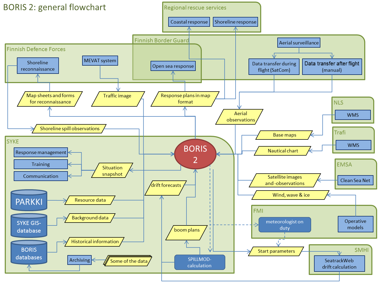
2 Background OILI-project Funded by Tekes (the Finnish Funding Agency for Technology and Innovation) Involved partners: SYKE, TKK, FIMR etc. Objectives: to create an operative, near real time system for oil spill detection, drift forecasting and map analysis to develop methods for detecting oil spills in satellite images to create possibilities for providing near real time accident information using internet or intranet services Result of the project was a system named BORIS (=Baltic Oil Response Information System)
3 A need to renew BORIS problems in using the BORIS service important functionality missing in the first version and some completely new requirements (Dornier-reform, SÖKÖ-project) changed situation regarding satellite images and spill observations outdated map technologies used for BORIS (ESRI MapObjects 2.1, old ArcMap)
4 BORIS 2 -project funded by Finnish Oil Pollution Fund and SYKE all oilspill authorities in Finland involved the objective is a versatile map system for oilspill combating containing static datasets satellite images and spills observed in them aerial and shoreline surveillance data possibility for calculating drift forecasts weather and environmental conditions tools for planning and managing response operations priorities: clarity, reliability and accessibility
5
6 A GIS which includes specialized map tools utilizes general map functionalities developed for the Finnish environmental administration (drawing, using map layers) utilizes data from many sources and in many ways automatic retrieval and processing (FMI, EMSA) WMS services (NLS, HELCOM, Trafi, MEVAT) users own datasets and documents enables versatile management of emergency data enables dynamic user management and user roles
7 Technology: Map service platform: ESRI ArcGIS Server 10.1 (kehitys 9.3) Application development platform: Silverlight (C#) Databases: SQL Server 2008
8 Team: project manager: Meri Hietala specifications and datasets: Meri Hietala, Heli Haapasaari, Kati Tahvonen, Samuli Neuvonen GIS technology: Mikko Hynninen, Ismo Lahtinen, Samuli Neuvonen data systems and communication: Sami Korhonen ja Seppo Aitamurto testing: Kati Tahvonen, Meri Hietala, Heli Haapasaari training: Kati Tahvonen, Samuli Neuvonen More info: project homepage
9 Samuli Neuvonen, SYKE DEMO 9
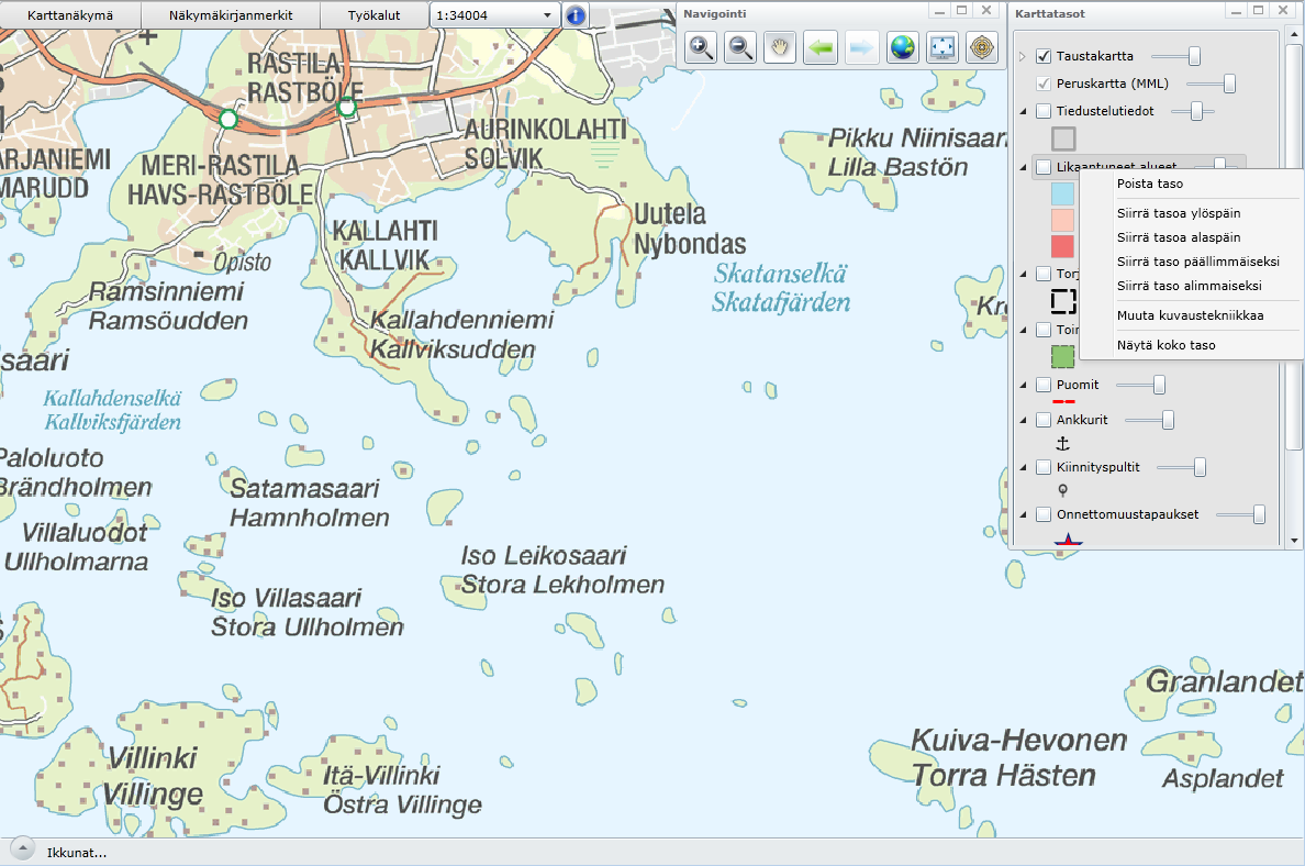
10 User interface in general Info-tool Scale menu Drop-down menus: datasets, windows, tools etc.
11 User interface in general navigation index map map layers
12 User interface in general coordinates window management notifications
13 User interface in general case data
14 Menus: map view 14
15 Menus: view bookmarks 15

16 Menus: view bookmarks 16
17 Menus: tools 17
18 Menus: tools 18

19 Menus: tools 19

20 Scale menu 20

21 Info-tool 21
22 Integration with OILRISK 22

23 Add OILRISK-data to map 23

24 Integration with OILRISK 24

25 Use info-tool to examine OILRISK-data 25

26 26
27 Layer management 27

28 Window management 28

29 Emergency case: case info 29

30 Emergency case : other tabs 30

31 Emergency case : map functions on tabs 31

32 Emergency case : map functions on tabs 32
33 Emergency case : editing features 33
34 Emergency case : editing features 34

35 Emergency case : editing features 35

36 Emergency case : boom draw 36

37 Emergency case : drift calculations 37

38 Emergency case : map entries 38


39 Emergency case : snapshots 39


40 Emergency case : attached documents 40
")
41 Emergency case : shore reconnaissance (SÖKÖ) 41
42 Work continues: project continues until 2013 with the following tasks metadata more datasets satellite- and aerial imagery (and observations) traffic image standard interfaces to outside systems user roles contingency planning reporting tools managing historical data development continues also after this, either through new projects or as part of official duties
43 Samuli Neuvonen, SYKE Thank you! 43
METIER Course No. 6: Remote Sensing & Hydrosphere Helsinki 6 November 2008 Kati Tahvonen Finnish Environment Institute
 The Use of Remote Sensing, Drifting Forecasts and GIS Data in Oil Response and Pollution Monitoring METIER Course No. 6: Remote Sensing & Hydrosphere Helsinki 6 November 2008 Kati Tahvonen Finnish Environment
Baltic Sea Perspective on - Building a Gas Pipeline and - Oil Spills
 Baltic Sea Perspective on - Building a Gas Pipeline and - Oil Spills Dr Juha-Markku Leppänen Head of the Monitoring and Assessment Unit, Marine Research Centre, Finnish Environment Institute (SYKE) Content
Contingency planning guide
 Contingency planning guide www.balticmaster.org This guide has been put together to introduce persons new to contingency planning to the process, give examples of topics and outlines for contingency plans
A Brief Explanation of Basic Web Services
 A Brief Explanation of Basic Web Services What is REST? REpresentational State Transfer (REST) is a way for software to work when distributed across a network. For example, if I want to view the Iowa Dept
Nenad Mladineo. Marko Mladineo. Marin Stosic
 Nenad Mladineo University of Split, Faculty of Civil Engineering, Architecture and Geodesy, Croatia mladineo@gradst.hr Marko Mladineo University of Split, Faculty of Electrical Engineering, Mechanical,
OUTCOME OF THE EIGHTH MEETING OF THE EXPERT WORKING GROUP ON RESPONSE ON THE SHORE (EWG SHORE 8-2014)
") Baltic Marine Environment Protection Commission Expert Working Group on Response on the Shore Riga, Latvia, 9-10 June 2014 OUTCOME OF THE EIGHTH MEETING OF THE EXPERT WORKING GROUP ON RESPONSE ON THE SHORE
Baltic Marine Environment Protection Commission Expert Working Group on Response on the Shore Riga, Latvia, 9-10 June 2014 OUTCOME OF THE EIGHTH MEETING OF THE EXPERT WORKING GROUP ON RESPONSE ON THE SHORE
Oil Spill Preparedness and Response: The Singapore Experience
 Oil Spill and : The Singapore Experience Capt M Segar Assistant Chief Executive (Operations) Maritime and Port Authority of Singapore Scope Introduction MPA s Strategy in Combating Oil Spill Regional Cooperation
Contents. The OWRB Floodplain Viewer. Creating Maps... 8. Helpful Tips... 10
 Contents QUICK START GUIDE... 2-5 Add layers...9 Search for Layers...9 COMPREHENSIVE GUIDE... 6 Navigate the map...6 Locate specific places...6 Add layer from file...9 Add layer from web...9 Display pop-up
Chapter 1: Introduction to ArcGIS Server
 Chapter 1: Introduction to ArcGIS Server At a high level you can think of ArcGIS Server as software that helps you take your geographic information and make it available to others. This data can be distributed
HELCOM Data and Map Service. User Manual
 HELCOM Data and Map Service User Manual Version 2.2 - February 2015 1 Table of contents 1. General Information... 3 1.1 Background... 3 1.2 Technical requirements... 3 1.3 Contact... 3 2. Accessing HELCOM
There are various ways to find data using the Hennepin County GIS Open Data site:
 Finding Data There are various ways to find data using the Hennepin County GIS Open Data site: Type in a subject or keyword in the search bar at the top of the page and press the Enter key or click the
Development of Oil Combating in the Gulf of Bothnia
 Development of Oil Combating in the Gulf of Bothnia BRISK Final Seminar Marina Congress Centre, Helsinki 8 December 2011 Jorma Rytkönen Finnish Environment Institute (SYKE) / Marine Pollution Response
Analysing Big Data in ArcGIS
 OIL & GAS Analysing Big Data in ArcGIS AIS based risk modelling Esri European Petroleum GIS Conference 2014 Karl John Pedersen 7th November 2014 1 DNV GL 2014 7th November 2014 SAFER, SMARTER, GREENER
Baltic Marine Environment Protection Commission
 Baltic Marine Environment Protection Commission Response Working Group Brussels, Belgium, 1-3 June 2015 RESPONSE 20-2015 Document title Arctic oil recovery exercise KEMI ARCTIC 2015 Code 11-1 Category
OPERATIONS DASHBOARD A PILOT PROJECT FOR SECURITY OPERATIONS SCAUG 2014
 OPERATIONS DASHBOARD A PILOT PROJECT FOR SECURITY OPERATIONS SCAUG 2014 ABOUT ACCESS THE NEED Access Midstream Corporate Security 24/7 Security Operations Center Tasked with ensuring employee, contractor
The Development of IALA-NET Data Center in China. Maritime Safety Administration (MSA) of the People's Republic of China
 of the People's Republic of China") The Development of IALA-NET Data Center in China Maritime Safety Administration (MSA) of the People's Republic of China IALA-NET is an IALA project It will be implemented if the trial demonstrates its
The Development of IALA-NET Data Center in China Maritime Safety Administration (MSA) of the People's Republic of China IALA-NET is an IALA project It will be implemented if the trial demonstrates its
How to georectify an image in ArcMap 10
 How to georectify an image in ArcMap 10 The University Library has a large collection of historical aerial photos for some North Carolina Counties ( http://www.lib.unc.edu/reference/gis/usda/index.html
What do I do first in ArcView 8.x? When the program starts Select from the Dialog box: A new empty map
 www.library.carleton.ca/find/gis Introduction Introduction to Georeferenced Images using ArcGIS Georeferenced images such as aerial photographs or satellite images can be used in many ways in both GIS
Kodiak Island Borough GIS Online Tools
 Kodiak Island Borough GIS Online Tools The Kodiak Island Borough website is located at http://www.kodiakak.us/ You can access the GIS resources by clicking on the MAP CENTER icon in the middle of the page,
Spatial Database Support
 Page 1 of 11 Spatial Database Support Global Mapper can import vector data from and export vector data to the following spatial databases: Esri ArcSDE Geodatabase Esri File Geodatabase Esri Personal Geodatabases
Working with Temporal Data
 Esri International User Conference San Diego, California Technical Workshops July 26 2012 Working with Temporal Data Aileen Buckley Mark Smithgall This technical workshop Visualizing temporal data recurring
Investigating World Development with a GIS
 Investigating World Development with a GIS Economic and human development is not consistent across the world. Some countries have developed more quickly than others and we call these countries MEDCs (More
1. Abstract. 2. The Problem / Need for the Program
 Program Information: Montgomery County, Maryland Program Title: A GIS Platform for Emergency Management and Response: Common Operational Pictures (COP) Program Category: # 14, Information Technology 1.
Dissemination of air quality information in Finland the national air quality portal
 Macedonian Twinning Project Study Tour in Finland 27-31.8.2007 Dissemination of air quality information in Finland the national air quality portal Virpi Tarvainen Head of Research Group Air Quality Research
ArcGIS Reference Document
 Migration of GIS Data to ArcSDE Page 1 of 10 Table of Contents A Brief Summary of DEP s GIS Data Storage o The Y Drive o ArcSDE (Spatial Database) Keeping Your GIS Project Data Current o Checking Your
GEOGRAPHIC INFORMATION SYSTEMS Lecture 20: Adding and Creating Data
 Adding Existing Data Into ArcGIS - there are many different ways to get data into ArcGIS GEOGRAPHIC INFORMATION SYSTEMS Lecture 20: Adding and Creating Data Add Data - normally we use the Add Data button
Finnish Marine Research Infrastructure FINMARI
 Finnish Marine Research Infrastructure FINMARI Lauri Laakso, Finnish Meteorological Institute Timo Tamminen, Finnish Environment Institute Finnish Meteorological Institute 1. National roadmap for key research
Taking Control of your System and Planning Your Future: Real Time Monitoring
 Advances in GIS Technology Taking Control of your System and Planning Your Future: Real Time Monitoring November 11, 2015 Topics Real-Time Monitoring Capabilities Quick Demo How do we improve uptime, increase
Web Editing Tutorial. Copyright 1995-2010 Esri All rights reserved.
 Copyright 1995-2010 Esri All rights reserved. Table of Contents Tutorial: Creating a Web editing application........................ 3 Copyright 1995-2010 Esri. All rights reserved. 2 Tutorial: Creating
ArcGIS. Image Server tutorial
 ArcGIS 9 ArcGIS Image Server tutorial Copyright 2006, 2007, and 2008 Zanja Technologies, Inc. All rights reserved. The information contained in this work is the property of Zanja Technologies, Inc., under
ArcGIS Web App Builder (AWAB) In BETA. John Bocan MES/DoIT john.bocan@maryland.gov
 In BETA. John Bocan MES/DoIT john.bocan@maryland.gov") ArcGIS Web App Builder (AWAB) In BETA John Bocan MES/DoIT john.bocan@maryland.gov Some Facts (1 slide) The Pros (5 slides) The Cons (2 slides) Some Bugs/Issues (1 slide) What s to Come (1 slide) What This
ArcGIS Web App Builder (AWAB) In BETA John Bocan MES/DoIT john.bocan@maryland.gov Some Facts (1 slide) The Pros (5 slides) The Cons (2 slides) Some Bugs/Issues (1 slide) What s to Come (1 slide) What This
ArcScan Tutorial. Copyright 1995-2010 Esri All rights reserved.
 Copyright 1995-2010 Esri All rights reserved. Table of Contents Exercise 1: Interactive vectorization........................... 3 Exercise 2: Automatic vectorization........................... 12 Copyright
ArcGIS Data Models Practical Templates for Implementing GIS Projects
 ArcGIS Data Models Practical Templates for Implementing GIS Projects GIS Database Design According to C.J. Date (1995), database design deals with the logical representation of data in a database. The
Finnish Experience in Oil Spill Prevention and Response in. The Baltic Sea
 Finnish Experience in Oil Spill Prevention and Response in The Baltic Sea 1 of 50 Finnish Experience in Oil Spill Prevention and Response in The Baltic Sea Report prepared by: Elena Fedorova, NorTech Oulu
Introduction to Imagery and Raster Data in ArcGIS
 Esri International User Conference San Diego, California Technical Workshops July 25, 2012 Introduction to Imagery and Raster Data in ArcGIS Simon Woo slides Cody Benkelman - demos Overview of Presentation
City of Corpus Christi. Mobile GIS Viewer. For ipad
 City of Corpus Christi Mobile GIS Viewer For ipad MIS - GIS 3/9/2012 P a g e 1 Contents Requirements... 2 Installation... 2 Using the ArcGIS Mobile App... 4 Connect to the Corpus Christi Mobile GIS Map
Tactical Oil Spill Management TOSM APTOMAR.COM
 Tactical Oil Spill Management TOSM APTOMAR.COM TCMS AIRBORNE OFFSHORE NEAR SHORE ONSHORE Operations Room Oil Rig Oil Rig Standby Vesel SECurus Radar Surveillance Aircraft TACTICAL OIL SPILL MANAGEMENT
Baltic Marine Environment Protection Commission
 Baltic Marine Environment Protection Commission Project on Development of a HELCOM Pollution Load User System Helsinki, Finland, 26-27 February 2014 PLUS 5-2014, 2-2 Document title Hosting and Application
Mapping Mashup/Data Integration Development Resources
 Mapping Mashup/Data Integration Development Resources David Hart GIS Specialist University of Wisconsin Sea Grant Institute October 6, 2008 Virtual Globes A virtual globe is a 3D software model or representation
ArcGIS Business Analyst Premium* ~ Help Guide ~ Revised October 3, 2012
 ArcGIS Business Analyst Premium* ~ Help Guide ~ Revised October 3, 2012 ArcGIS Business Analyst Premium is an Esri software package that combines GIS analysis and visualization with data to provide a better
Latin American and Caribbean Flood and Drought Monitor Tutorial Last Updated: November 2014
 Latin American and Caribbean Flood and Drought Monitor Tutorial Last Updated: November 2014 Introduction: This tutorial examines the main features of the Latin American and Caribbean Flood and Drought
Getting Census Data into ArcMap or ArcView. Obtaining Shapefiles from ESRI and Data from the Census Bureau
 Obtaining Shapefiles from ESRI and Data from the Census Bureau 1) Download the boundary shapefile from the ESRI website: http://arcdata.esri.com/data/tiger2000/tiger_download.cfm. Select the area that
Cool New Tools In Network Analysis. Scott Sandusky
 Cool New Tools In Network Analysis Scott Sandusky Cool New Tools in Network Analysis Learn about the new functionality available in the Network Analyst extension and in the ArcGIS Online Network Analysis
IDOT Getting Around Illinois Interactive Map Quick Reference Guide
 IDOT Getting Around Illinois Interactive Map Quick Reference Guide 1 2 3 4 5 6 7 8 9 10 1) Navigation Tools The Navigation tools are used to reposition the visible area on the map display. Zoom In Clicking
Raster Tutorial. Copyright 1995-2010 Esri All rights reserved.
 Copyright 1995-2010 Esri All rights reserved. Table of Contents Introduction to the ArcGIS raster tutorial......................... 3 Exercise 1: Creating a mosaic dataset.......................... 4 Exercise
PHASE 2_3 RD SESSION REPORT KU GIS LABS ARCGIS TRAINING: USING ARCGIS (APPLICATIONS) 18 TH - 22 ND AUGUST 2014 SCHOOL OF ENGINEERING COMPUTER LAB
 18 TH - 22 ND AUGUST 2014 SCHOOL OF ENGINEERING COMPUTER LAB") PHASE 2_3 RD SESSION REPORT KU GIS LABS ARCGIS TRAINING: USING ARCGIS (APPLICATIONS) 18 TH - 22 ND AUGUST 2014 SCHOOL OF ENGINEERING COMPUTER LAB PHASE 2_3 rd SESSION REPORT ARCGIS TRAINING: 18 TH - 22
PHASE 2_3 RD SESSION REPORT KU GIS LABS ARCGIS TRAINING: USING ARCGIS (APPLICATIONS) 18 TH - 22 ND AUGUST 2014 SCHOOL OF ENGINEERING COMPUTER LAB PHASE 2_3 rd SESSION REPORT ARCGIS TRAINING: 18 TH - 22
Introduction to ArcGIS Network Analyst. Presenter: Matt Crowder ESRI Redlands, California
 Introduction to ArcGIS Network Analyst Presenter: Matt Crowder ESRI Redlands, California Seminar overview Topics What is Network Analyst? What is Network Analyst used for? What is the network dataset?
GIS and Document Management Integration
 GIS and Document Management Integration Presented by: Steve Sherman, GISP City of Greensboro, NC ESRI Conference 2007 Presentation Goals Definition of Document Management What it is? Why it s s important
EXPLORING AND SHARING GEOSPATIAL INFORMATION THROUGH MYGDI EXPLORER
 EXPLORING AND SHARING GEOSPATIAL INFORMATION THROUGH MYGDI EXPLORER Subashini Panchanathan Malaysian Centre For Geospatial Data Infrastructure ( MaCGDI ) Ministry of National Resources and Environment
National Register of Historic Places: GIS Webinar Cultural Resource GIS Facility National Park Service June 2012
 National Register of Historic Places: GIS Webinar Cultural Resource GIS Facility National Park Service June 2012 In February and March 2012 the National Register of Historic Places held webinars in conjunction
ArcGIS 9. Installation Guide: Workgroup for Microsoft SQL Server Express
 ArcGIS 9 Installation Guide: Workgroup for Microsoft SQL Server Express Copyright 2006 ESRI All Rights Reserved. Printed in the United States of America. The information contained in this document is the
FUTURE DATA Yes, it s finally coming to the PI System!
 FUTURE DATA Yes, it s finally coming to the PI System! Presented by Steve Kwan Denis Vacher Product Manager, PI Server Engineering Group & Initiative Lead Presenter Bios Steve Kwan is the Product Manager
POLAR ICE Integrated Arctic and Antarctic Sea Ice monitoring Services
 VTT TECHNICAL RESEARCH CENTRE OF FINLAND LTD Place for a photo (no lines around photo) Photo: Tapio Nyman http://www.polarice.eu/ POLAR ICE Integrated Arctic and Antarctic Sea Ice monitoring Services Robin
University of Arkansas Libraries ArcGIS Desktop Tutorial. Section 4: Preparing Data for Analysis
 : Preparing Data for Analysis When a user acquires a particular data set of interest, it is rarely in the exact form that is needed during analysis. This tutorial describes how to change the data to make
Title: SharePoint Advanced Training
 416 Agriculture Hall Michigan State University 517-355- 3776 http://support.anr.msu.edu support@anr.msu.edu Title: SharePoint Advanced Training Document No. - 106 Revision Date - 10/2013 Revision No. -
Uni Sales Analysis CRM Extension for Sage Accpac ERP 5.5
 SAGE ACCPAC OPTIONS Sage Accpac Options Uni Sales Analysis CRM Extension for Sage Accpac ERP 5.5 User Guide 2008 Sage Software, Inc. All rights reserved. Sage Software, Sage Software logos, and all Sage
ArcGIS Viewer for Silverlight An Introduction
 Esri International User Conference San Diego, California Technical Workshops July 26, 2012 ArcGIS Viewer for Silverlight An Introduction Rich Zwaap Agenda Background Product overview Getting started and
Network Analysis with ArcGIS for Server
 Esri International User Conference San Diego, California Technical Workshops July 24, 2012 Network Analysis with ArcGIS for Server Deelesh Mandloi Dmitry Kudinov Introduction Who are we? - Network Analyst
Working with SQL Profiler
 Working with SQL Profiler This tutorial complements the article Tracing ArcSDE Queries with SQL Profiler, by Shannon Shields and Joseph Buckles which appeared in the January March 2002 issue of ArcUser
Linear Referencing Tutorial
 Copyright 1995-2010 Esri All rights reserved. Table of Contents An overview of the linear referencing tutorial........................ 3 Exercise 1: Organizing your linear referencing data in ArcCatalog...............
13/10/2011. Data Integration and Interoperability. Gordon Sumerling & Maree Wilson
 Data Integration and Interoperability Gordon Sumerling & Maree Wilson 1 Agenda Seamless integration between GIS and CAD CAD Support in ArcGIS Using GIS Data in CAD Editing GIS Data in CAD Introduction
Shipping accidents in the Baltic Sea in 2012
 Baltic Marine Environment Protection Commission Annual report on Shipping accidents in the Baltic Sea in 2012 Photo:Metsähallitus NHS/Ulrika Björkman Photo: Maritime Office of Gdynia Published by: HELCOM
Contract & Document Management on SourceDogg
 w Contract & Document Management on SourceDogg Date: Contents Heading 1... 2 Heading 2... Error! Bookmark not defined. Heading 3... Error! Bookmark not defined. 1 Contents Contents... 2 1. Introduction...
EMSA s Integrated Maritime Environment. Justino de Sousa. October 2012. - a tool for improved Maritime Domain Awareness
 EMSA s Integrated Maritime Environment - a tool for improved Maritime Domain Awareness October 2012 1 Justino de Sousa European Maritime Safety Agency C.3.1 Integrated Maritime Data Introduction : the
Geography 3251: Mountain Geography Assignment III: Natural hazards A Case Study of the 1980s Mt. St. Helens Eruption
 Name: Geography 3251: Mountain Geography Assignment III: Natural hazards A Case Study of the 1980s Mt. St. Helens Eruption Learning Objectives: Assigned: May 30, 2012 Due: June 1, 2012 @ 9 AM 1. Learn
Finding GIS Data and Preparing it for Use
 Finding_Data_Tutorial.Doc Page 1 of 19 Getting Ready for the Tutorial Sign Up for the GIS-L Listserv Finding GIS Data and Preparing it for Use The Yale University GIS-L Listserv is an internal University
Recruitment Management System (RMS) User Manual
 User Manual") Recruitment Management System (RMS) User Manual Contents Chapter 1 What is Recruitment Management System (RMS)? 2 Chapter 2 Login/ Logout RMS Chapter 3 Post Jobs Chapter 4 Manage Jobs Chapter 5 Manage
Recruitment Management System (RMS) User Manual Contents Chapter 1 What is Recruitment Management System (RMS)? 2 Chapter 2 Login/ Logout RMS Chapter 3 Post Jobs Chapter 4 Manage Jobs Chapter 5 Manage
NetCDF Tutorial. Copyright 1995-2010 Esri All rights reserved.
 Copyright 1995-2010 Esri All rights reserved. Table of Contents About the netcdf Tutorial............................... 3 Exercise 1: Displaying a raster layer from a netcdf file................... 4
RELEASE NOTES. Introduction. New in this release. Trimble Positions Mobile extension
 RELEASE NOTES Trimble Positions Mobile extension These release notes provide important information about the Trimble Positions Mobile extension version 10.2.0.1. Please read these release notes carefully.
CRMS Website Training
 CRMS Website Training March 2013 http://www.lacoast.gov/crms Coastwide Reference Monitoring System - Wetlands CWPPRA Restoration Projects Congressionally funded in 1990 Multiple restoration techniques
MrSID Plug-in for 3D Analyst
 LizardTech MrSID Plug-in for 3D Analyst User Manual Copyrights Copyright 2009 2010 LizardTech. All rights reserved. Information in this document is subject to change without notice. The software described
Exercise 3: Building a GIS data library
 The Scenario You are preparing for an interview for a GIS position for a particular county. They asked that you present a GIS demonstration as part of your interviewing process. You decide to develop a
An Introduction to Box.com
 An Introduction to Box.com Box is an online file sharing and cloud content management service and it provides features such as: Security controls Space Mobility Online collaboration Mobile access Version
Google Earth Digitale Wege in eine bekannte Welt Sep. 2006
 Google Earth Digitale Wege in eine bekannte Welt Sep. 2006 Joachim Glaubrecht Google Enterprise joachim@google.com What is Google Enterprise? 2 1 Focus.de: "Der Papst-Besuch in Google Earth" 3 How to Geo
StreamServe Persuasion SP5 Control Center
 StreamServe Persuasion SP5 Control Center User Guide Rev C StreamServe Persuasion SP5 Control Center User Guide Rev C OPEN TEXT CORPORATION ALL RIGHTS RESERVED United States and other international patents
RFID Lab Finland ry www.rfidlab.fi
 RFID Lab Finland ry www.rfidlab.fi Mikko Punakivi Executive Director Sami Kalliokoski Development Manager RFIDLab Finland in a Nutshell Neutral RFID information Leading the Finnish RFID Cluster Supporting
ArcGIS 1: Introduction to GIS. Student Edition
 ArcGIS 1: Introduction to GIS Student Edition Copyright 2016 Esri All rights reserved. Course version 4.0. Version release date March 2016. Printed in the United States of America. The information contained
Build an ArcGIS Online Application
 Build an ArcGIS Online Application Sign into ArcGIS Online for Maryland 1. Open a web browser 2. Go to URL http://maryland.maps.arcgis.com/ 3. Click Sign In in the upper right corner of the web page 4.
Energy efficient Indoor Environments- Indoor pilot
 Energy efficient Indoor Environments- Indoor pilot Eija Parmes, Kari Rainio, Paula Järvinen, Pekka Siltanen, VTT Teemu Vesanen, Jorma Pietiläinen, Mikko Tuomisto, VTT Harri Hahkala, Jorma Säteri, Metropolia
MultiSite Manager. User Guide
 MultiSite Manager User Guide Contents 1. Getting Started... 2 Opening the MultiSite Manager... 2 Navigating MultiSite Manager... 2 2. The All Sites tabs... 3 All Sites... 3 Reports... 4 Licenses... 5 3.
Baltic Marine Environment Protection Commission
 Baltic Marine Environment Protection Commission Heads of Delegation Laulasmaa, Estonia, 15-16 June 2016 HOD 50-2016 Document title Progress in modernization of HELCOM data management systems Code 4-23-Corr.
Login/ Logout RMS Employer Login Go to Employer and enter your username and password in the Employer Login section. Click on the LOGIN NOW button.
 Recruitment Management System Version 8 User Guide What is Recruitment Management System (RMS)? Recruitment Management System (RMS) is an online recruitment system which can be accessed by corporate recruiters
Subject: Using Google Earth, Google Earth Pro, and Google Maps for FWS activities
 Subject: Using Google Earth, Google Earth Pro, and Google Maps for FWS activities Page 1 of 5 As an FWS employee, can I use Google mapping software or applications to help me with my job? The short answer
City of Grand Junction and inframap Software Mobile Field Application
 1 City of Grand Junction and inframap Software Mobile Field Application City Of Grand Junction Grand Junction Colorado Scott List inframap Software Adam Hagee Colin Kennedy Grand Junction Background 2
Agenda. How to configure
 dlaw@esri.com Agenda Strongly Recommend: Knowledge of ArcGIS Server and Portal for ArcGIS Security in the context of ArcGIS Server/Portal for ArcGIS Access Authentication Authorization: securing web services
Embedding Maps into Microsoft Office and Microsoft SharePoint
 Embedding Maps into Microsoft Office and Microsoft SharePoint Toronto Esri Canada User Conference Tuesday, October 16, 2012 Presented By: Heather Hainsworth hhainsworth@esri.ca Agenda This seminar is designed
Process Document Campus Community: Create Communication Template. Document Generation Date 7/8/2009 Last Changed by Status
 Document Generation Date 7/8/2009 Last Changed by Status Final System Office Create Communication Template Concept If you frequently send the same Message Center communication to selected students, you
North Dakota GIS Program Report To Governor Jack Dalrymple. July 1, 2011 June 30, 2012
 North Dakota GIS Program Report To Governor Jack Dalrymple July 1, 2011 June 30, 2012 Executive Order 2001-06: The committee shall issue a report to the Governor's office at the end of each fiscal year,
GEOGRAPHIC INFORMATION GATEWAY New York Department of State (NYDOS) data acceptance & metadata standards
 data acceptance & metadata standards") GEOGRAPHIC INFORMATION GATEWAY New York Department of State (NYDOS) data acceptance & metadata standards 1. DATA ACCEPTANCE STANDARDS The following describes the data acceptance standards for data included
GEOGRAPHIC INFORMATION GATEWAY New York Department of State (NYDOS) data acceptance & metadata standards 1. DATA ACCEPTANCE STANDARDS The following describes the data acceptance standards for data included
Help Document for WWW.SAGIS.ORG. Step by step, how-to instructions for navigating and using the Savannah Area GIS viewer.
 Help Document for WWW.SAGIS.ORG Step by step, how-to instructions for navigating and using the Savannah Area GIS viewer. 1 SAGIS Savannah Area GIS is focused on providing access to Geospatial data in a
Coupling Bayesian networks and geospatial software for environmental risk assessment
 19th International Congress on Modelling and Simulation, Perth, Australia, 12 16 December 2011 http://mssanz.org.au/modsim2011 Coupling Bayesian networks and geospatial software for environmental risk
ArcGIS 9. Installation Guide: ArcSDE for SQL Server Express licensed through ArcGIS Server Workgroup
 ArcGIS 9 Installation Guide: ArcSDE for SQL Server Express licensed through ArcGIS Server Workgroup Copyright 2006-2008 ESRI All Rights Reserved. Printed in the United States of America. The information
Email Subscription vs. RSS:
 Email Subscription vs. RSS: You Decide Cathy Miller Business Writer/Consultant INTRODUCTION We all have our own preferences in how we do things. That s what makes us unique. When you find a blog that you
Using CAD Data in ArcGIS
 Esri International User Conference San Diego, California Technical Workshops July 27, 2012 Using CAD Data in ArcGIS Jeff Reinhart & Phil Sanchez Agenda Overview of ArcGIS CAD Support Using CAD Datasets
Perform this procedure when you need to add a recurring payment option, or when you need to change or withdraw it.
 Purpose Use this procedure to add, change, or remove recurring payments. Trigger Perform this procedure when you need to add a recurring payment option, or when you need to change or withdraw it. Prerequisites
Creating Connection with Hive
 Creating Connection with Hive Intellicus Enterprise Reporting and BI Platform Intellicus Technologies info@intellicus.com www.intellicus.com Creating Connection with Hive Copyright 2010 Intellicus Technologies
ARIZONA DEPARTMENT OF TRANSPORTATION. Presented by Lonnie D. Hendrix, P.E. Assistant State Engineer, Maintenance
 ARIZONA DEPARTMENT OF TRANSPORTATION Presented by Lonnie D. Hendrix, P.E. Assistant State Engineer, Maintenance Prepared by Feature Inventory Services Team July 2013 FIS Database Feature Inventory System
ESRI Technical Certification Overview. Amy Daniels Instructor, Greenville Tech
 ESRI Technical Certification Overview Amy Daniels Instructor, Greenville Tech Why have certification by ESRI? It communicates your proficiency in ESRI software Similar to Microsoft Certification, it can
Database Servers Tutorial
 Copyright 1995-2010 Esri All rights reserved. Table of Contents A quick tour of the database servers tutorial........................ 3 Exercise 1: Add a database server to the Catalog tree and create
ArcGIS. Server. A Complete and Integrated Server GIS
 ArcGIS Server A Complete and Integrated Server GIS ArcGIS Server A Complete and Integrated Server GIS ArcGIS Server enables you to distribute maps, models, and tools to others within your organization