The total mine drainage flow in the Mahanoy Creek watershed is MGD. Of the thirty-one discharges in the watershed, only twelve discharges
|
|
|
- Logan James
- 7 years ago
- Views:
Transcription
1 POLLUTION SOURCES There are two major sources of pollution in the study area. These sources are coal mine drainage and raw sewage. Two additional sources of pollution, silt content in streams and leachates from silt and culm banks, become important locally. Silting operations at the active mines and breakers as well as silt piles located on or near the banks of the streams contribute large amounts of silt during heavy rainfalls which overload the streams. The locations of many of these refuse piles are shown in Plates A and B. The silt, particularly in the Shenandoah Creek, changes the streams from their usual color to a muddy black color and forms large deposits of silt banks along the streambeds. Water percolating through the numerous refuse piles picks up acid and other oxidation products, if enough pyrite is available, before emerging as seepage discharges at the bottom of the piles. Examples of this type of discharge are the refuse piles near the Hammond Bore Hole (Site 25, Plate B) and along the stream banks at several points along the Shenandoah Creek. While the amounts of acid produced may be important locally, acid production is usually insignificant in comparison to the volume of the mine discharges. One of the major sources of pollution to the streams is raw sewage. As of this writing the only sewage treatment plants in the watershed is a small plant located in Trevorton, and a plant located in Ashland. All of the other towns in the area discharge their wastes into the streams. The high ph and alkalinity of sewage aid in the neutralization of acid mine discharges in the streams. This affect is probably a much stronger influence on the acidity in the stream under most conditions than the acid produced by the oxidation of ferrous iron in the streams. Coal mine drainage, the result of thirty-one mine discharges in the watershed, is the most important source of water pollution in the region. The distribution of these discharges is dependent on the locations of the many mine openings found in the watershed. As the level of the mine pools fluctuate in response to climatic conditions, mine discharges may disappear only to reappear after heavy rainfalls. Many of the discharge flows are affected by rainfall. This can be seen in the Appendix where monthly variations of the discharges are given. The location of all discharge points and their relation to the mining features of the watershed are shown in Plates A and B. The discharge parameters, such as which mine pool the discharge drains and the type of overflow, are given in Table 8 along with the land ownerships where these discharges are located. Descriptions of all discharges are discussed in groups where possible, the details being included in the Appendix. 75

2 The total mine drainage flow in the Mahanoy Creek watershed is MGD. Of the thirty-one discharges in the watershed, only twelve discharges account for almost 91 percent of the total flow. Most of the discharges and hence a large portion of the total mine drainage flow (71%) is concentrated from Ashland east to Delano (the eastern half of the watershed.) 76
 is")
3 77

4 78
5 79

6 MAHANOY CITY GROUP DISCHARGES The Headwaters Mahanoy Creek Discharge (1), which seeps from an abandoned slope located 1-1/2 miles east of Mahanoy City, is considered the headwaters of Mahanoy Creek (see Plates A and B). The slope drains a small portion of the Park No's 1 and 2 Mine Pool via the Morris Colliery Tunnel, and discharges AMD at an elevation of 1370 feet ±. The flow from the discharge fluctuates greatly and during extremely dry periods ceases to flow. Over the length of the study period the average flow was 0.24 MGD, with a ph of 3.4 and an acid concentration of 167 ppm. The iron and sulfate contents are 1.67 and 200 ppm respectively. The discharge contributes 315 lbs/day acid, 3 lbs/day iron, and 363 lbs/day sulfate into the Mahanoy Creek. The Mahanoy City Bore Hole Discharge (4) flows from a series of bore holes located just off the south side of Route 54 at the eastern edge of Mahanoy City. During periods of heavy precipitation another bore hole located approximately 600 feet due east of the previously mentioned bore holes, also overflows. The average flow from the discharge is 7.31 MGD, with a ph of 4.6 and an acid concentration of 140 ppm. The average iron and sulfate contents are and 229 ppm respectively. During the study period, an average of 6878 lbs/day acid, 724 lbs/day iron, and 14,658 lbs/day sulfate entered Mahanoy Creek from this discharge. The bore holes which overflow at an elevation of 1245 feet, drain the Vulcan-Buck Mountain Mine Pool. The area contributing to the mine pool, and hence, the discharge, encompasses roughly 2.2 square miles east and northeast of Mahanoy City. The entire area is scattered with strip pits and waste piles, with the strip pits being relatively small and overgrown with vegetation. The Mahanoy City Bore Hole Discharge flows into Mahanoy Creek, but at the confluence the discharge is actually a much larger flow than the creek itself. This is one of the more significant pollution sources accounting for 8.7 percent of all mine drainage entering Mahanoy Creek. GILBERTON SHAFT DISCHARGE The Gilberton Shaft Discharge (7) consists of a pumping station located at the eastern end of Gilberton, that intermittently pumps water from the mine pools below. The purpose of the pumping station is to maintain the elevation of the mine pool at a sufficient level so no flooding of basements occurs in the area. During periods of heavy precipitation the pump is in operation almost constantly, and conversely during dry periods the pump is seldom in use. The pump which delivers water to Mahanoy Creek at the rate of MGD, is considered to be in operation 40 percent of the time. The discharge has a ph of 6.3 and has a net acidity of 55.2 ppm. The iron and sulfate concentrations are and 862 ppm. The Gilberton Shaft Discharge accounts for 3534 lbs/day acid, 3793 lbs/day iron, and 55,185 lbs/day sulfate which enter Mahanoy Creek. 80

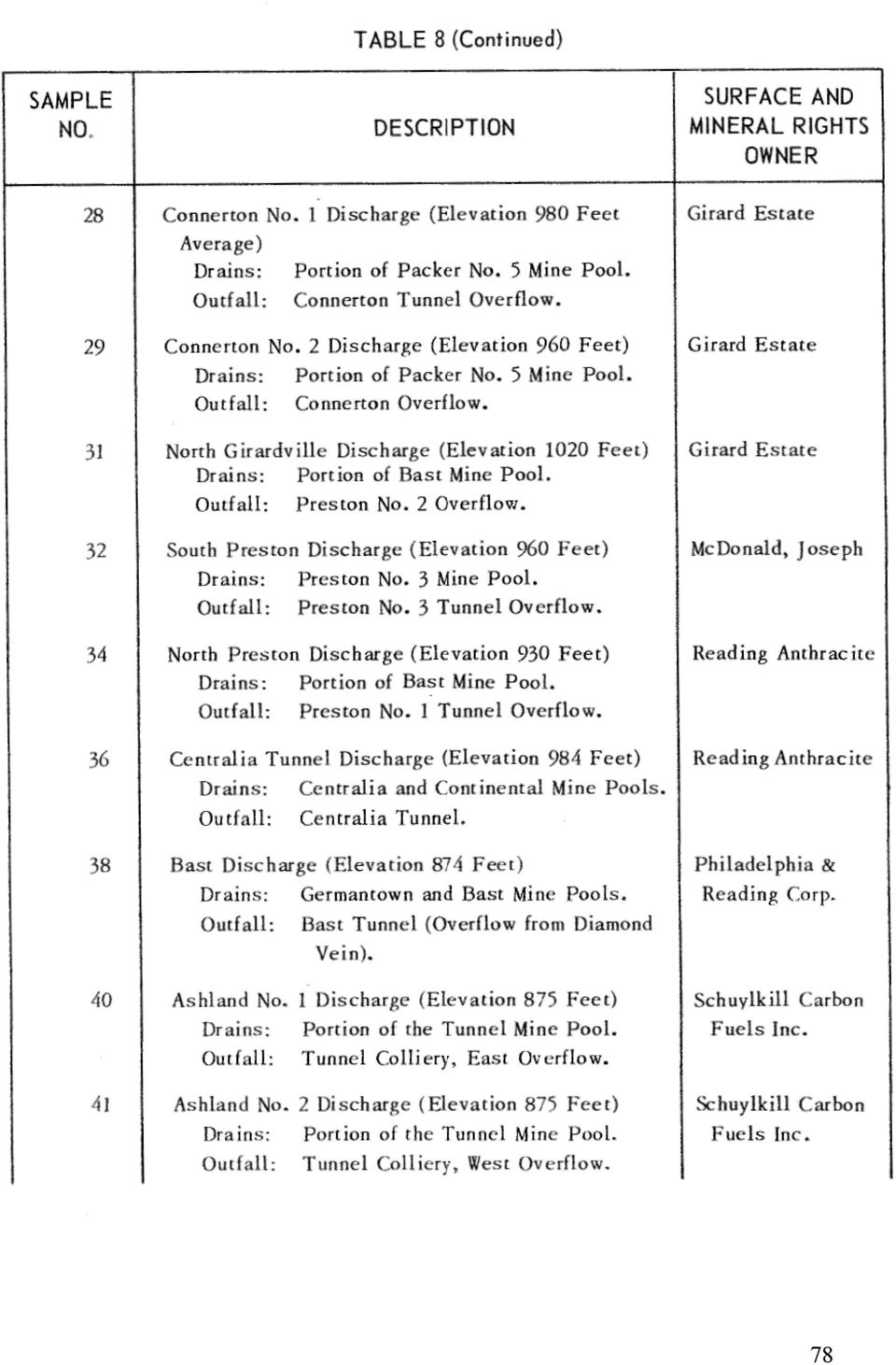
7 The mine pools drained by the Gilberton Shaft Discharge include the West Bear Ridge, Lawrence, East Bear Ridge, and the Gilberton Mine Pools, also included may be the St. Nicholas, Boston Run and the Tunnel Ridge Mine Pools. 3.2 square miles of land contributes water to the discharge with most of it strip mined. The area is scattered with waste and silt piles, and numerous strip pits, with little if any vegetative cover. GIRARDVILLE DISCHARGES The Girardville Discharges are a series of four discharges located along the south bank of Mahanoy Creek just east of Girardville. In addition a series of seepages occurs along the creek from sample site 9 to 14. The surface area contributing to the discharges is located south and southeast of Girardville, and includes 0.93 square miles, of which 0.46 have been stripped. The strip pits run along the base of Ashland Mountain trapping all surface runoff and directing it into the Girard Mine Pool. Although all discharges drain the same mine pool, their water quality differs significantly. Girardville No's 1, 2 and 3 consist of two adjacent discharges which are sampled as one, resulting in three rather than six discharges. The Girardville No. 1 (10) and the Girardville No. 2 (11) Discharges are both overflows of the old Girard Workings at elevation 1005 feet ±. The Girardville No. 1 Discharge has a flow rate of 1.99 MGD with a ph of 5.9 and a net acidity of 24 ppm. The discharge contributes 450 lbs/day acid, 422 lbs/day iron, and 7823 lbs/day sulfate into Mahanoy Creek. The iron and sulfate concentrations are and 466 ppm respectively. The Girardville No. 2 Discharge has a flow rate of 0.63 MGD and chemical characteristics similar to those just mentioned. The ph is 6.4 with a net alkalinity of 4 ppm, while the iron and sulfate contents are and 429 ppm respectively. The Girardville No. 2 Discharge accounts for 37 lbs/day alkalinity, 98 lbs/day iron and 2283 lbs/day of sulfate which enter Mahanoy Creek. The Girardville No. 3 Discharge (12) is an overflow of McTurks Bore Hole at elevation 980 feet ±. The ph is 5.9, with a net acidity of 38 ppm. The iron and sulfate contents are and 324 ppm respectively. The flow rate is 0.28 MGD. An average of 86 lbs/day net acidity, 36 lbs/day iron, and 750 lbs/day sulfate enter Mahanoy Creek from this discharge. The Girardville No. 4 Discharge (13) overflows the Girard Colliery Tunnel at 1000 feet ±. The flow is quite small averaging only 0.06 MGD with ph 3.7 and acid concentration of 99 ppm. The iron and sulfate contents are and 352 ppm. The Girardville No. 4 Discharge contributes 45 pounds of acidity, 5 pounds iron, and 170 pounds of sulfates daily to Mahanoy Creek. 81

8 PACKER GROUP DISCHARGES The Packer No. 5A Discharge (15) surfaces at the eastern end of Girardville through the Packer No. 5 East Overflow. The discharge flows westward through a series of ditches and culverts before entering Mahanoy Creek. The elevation of the outfall is 966 feet ±, and the flow which fluctuated significantly during the study period averaged MGD. The discharge ph is 6.3 and has a net alkaline concentration of 115 ppm, while the iron and sulfate contents are and 1037 ppm respectively. The pollution loads entering Mahanoy Creek from the discharge are 12,136 lbs/day net alkalinity, 3118 lbs/day iron and 101,404 lbs/day sulfates. The Packer No. 5B Discharge (16) surfaces from a series of openings west of the 5A Discharge and flows directly into it.. The discharge's outfall is the Packer No. 5 West Overflow and emerges at an elevation of 952 feet ±. This discharge drains the same area as that drained by the Packer No. 5A Discharge. The average flow from the 5B Discharge is MGD with a ph of 6.3 and a net alkaline concentration of ppm. The iron and sulfate contents are and 1235 ppm respectively. The Packer No. 5B Discharge contributes 13,071 lbs/day net alkalinity, 3875 lbs/day iron and 152,866 lbs/day sulfates to Mahanoy Creek. The combined flows of the Packer Discharges account for 31.7 percent of the total mine drainage entering Mahanoy Creek. Through a series of barrier pillar breaches, the Packer Discharges drain all or portions of 14 different mine pools, these include the Packer No. 5, Weston, William Penn, Kohinoor, West Shenandoah, Kehley Run, Indian Ridge, Maple Hill, Shenandoah City, Knickerbocker, North Mahanoy, Mahanoy City, Primrose, and the Park No's 1 and 2 Mine Pools. Approximately 30 square miles of surface area, stretching from Girardville eastward to Mahanoy City and northward to the watershed boundary, contributes water to the mine pools. Included in the area are some 11.9 square miles containing strip mines and waste piles. The most disturbed areas are those along Bear Ridge southeast of Lost Creek, and northwest of Mahanoy City. The stripped areas are characterized by large deep pits with near vertical slopes and huge piles of waste rock, little if any vegetation is present. A number of silt piles can be found in this area, most notably those along Mahanoy Creek from below Mahanoy City to Gilberton and again along North Mahanoy Creek. The upper slopes of Locust Mountain north of Shenandoah through Mahanoy City has no coal, and therefore has not been disturbed by mining. Lost Creek, Kehley Run, Waste House Run and North Mahanoy Creek, all of which are unpolluted, drain this area. In the case of Lost Creek, Waste House Run and Kehley Run, the water flows down the mountain, only to be intercepted by crop falls or stripping pits where the water is directed to the mine pools and later becomes a portion of the AMD that flows from the Packer 82

9 Discharges. These unpolluted streams draining Locust Mountain contribute approximately 3.52 MGD to the Packer Discharges. Within the area being drained by the Packer Discharges, are four additional discharges. These discharges drain portions of mine pools also being drained by the Packer Discharges. The Lost Creek Discharge (21) is a very minor discharge located 2000 feet northeast of the village of Lost Creek. The discharge has an average flow of 0.15 MGD. The ph is 4.0 and the acid content is 23 ppm. The iron and sulfate concentrations are 0.47 and 160 ppm respectively. The discharge which generates 35 lbs/day acidity, 1 lb/day iron, and 197 lbs/day sulfates, is an overflow of the West Slope to the Buck Mountain Bed at elevation 1205 feet. The discharge which drains a portion of the Weston Mine Pool, is presently entering a mine slope at the bottom of an abandoned strip mine. The Lost Creek Ball Field Discharge (23) is located in the village of Lost Creek. The discharge whose outfall is the Packer No. 2 Overflow at elevation 1030 feet ±, drains portions of the Weston and William Penn Mine Pools. The discharge, which enters Shenandoah Creek, flowed intermittently during the study period in response to mine pool level changes due to precipitation, with an average flow of 0.61 MGD. The ph value was 6.4, with a net alkaline, concentration of 49 ppm. The iron and sulfate concentrations were 21.5 and 929 ppm. An average of 434 pounds net akalinity, 183 pounds iron and 8314 pounds sulfates enter Shenandoah Creek from this discharge. The Connerton No. 1 Discharge (28) (1.3 percent of the total mine drainage flow) which overflows the old Connerton Tunnel at elevation 980 ±, drains a portion of the Packer No. 5, and possibly the Hammond Mine Pools. The discharge emerges at a series of locations near the northeastern edge of Girardville before flowing through a swamp and then entering Shenandoah Creek. The average flow from the discharge is 1.10 MGD with a ph of 6.7 and a net alkalinity of 234 ppm. The iron and sulfate contents are 2.80 and 865 ppm respectively. The Connerton No. 1 Discharge contributes 2200 lbs/day net alkalinity, 26 lbs/day iron and 7571 lbs/day sulfates to Shenandoah Creek. The Connerton No. 2 Discharge (29) located at the. eastern edge of Girardville also enters Shenandoah Creek. The discharge drains a portion of the Packer No. 5 Mine Pool through the Connerton Overflow at elevation 960 feet ±. Although the flow is not significant it is quite constant, averaging 0.13 MGD during the study period. The ph of the discharge is 6.4, with an alkaline concentration of 100 ppm. Both the iron and sulfate contents are very high being and 1097 ppm respectively. The discharge accounts for 88 lbs/day of net alkalinity, 36 lbs/day of iron, and 1134 lbs/day of sulfates which enter Shenandoah Creek. 83

10 HAMMOND DISCHARGES Located 6000 feet northeast of Girardville, the Hammond Bore Hole Discharge (25) (3 percent of the total mine drainage) drains the Hammond Mine Pool. The discharge which is an overflow of the Hammond Bore Hole at elevation 1000 feet ±, drains to Shenandoah Creek. The 1.34 square miles of land that contributes water to the mine pool, has been almost entirely disturbed by mining. Although the area has a relatively small number of strip pits, a vast number of waste piles dominate the entire region. The average flow from the discharge is 2.53 MGD and is quite consistent. The ph is 6.2 with an alkalinity of 80 ppm. The iron and sulfate concentration are extremely high being and 1002 ppm respectively. An average of 1542 lbs/day net alkalinity, 978 lbs/day iron and 20,546 lbs/day sulfates are introduced into Shenandoah Creek by the Hammond Bore Hole Discharge. Also draining a small portion of the Hammond Mine Pool is the Hammond Discharge (26). The discharge located 300 feet northeast of the Hammond Bore Hole Discharge flows only during wet periods. The average flow during the study period was 0.01 MGD, with a ph of 4.1 and an acid concentration of 211 ppm. The iron and sulfate contents are and 1171 ppm. The discharge is an overflow of an exposed portion of the Hammond Mine Pool at elevation 1020 feet ±, and contributes 35 lbs/day acidity, 3 lbs/day iron and 183 lbs/day of sulfates to Shenandoah Creek. SOUTH PRESTON DISCHARGE The South Preston Discharge (32) (1.2 percent of the total mine drainage) is located in the southwest section of Girardville and overflows the old Preston No. 3 Tunnel at an elevation of 960 feet ±. The discharge which enters Mahanoy Creek has a relatively consistent flow which averages 1.04 MGD. The ph of the discharge is 6.5 with a net alkaline concentration of 29 ppm. The average iron content is ppm while the sulfate content is 240 ppm. The South Preston Discharge contributes 291 lbs/day net alkalinity, 114 lbs/day iron, and 1864 lbs/day of sulfates to Mahanoy Creek. The discharge drains the Preston No. 3 Mine Pool which is located southwest of Girardville. Approximately 0.60 square miles of strip mine overlie the mine pool and an additional 0.31 square miles of undisturbed land on the upper slope of Ashland Mountain contributes to the discharge. The stripping are characterized by long narrow pits which follow the contour of the land very closely. The vegatative growth on the stripped areas varies from next to nothing to a dense thicket. 84

11 CENTRALIA TUNNEL DISCHARGE The Centralia Tunnel Discharge (36) is located approximately 5000 feet northeast of the eastern edge of Ashland. The discharge overflows the old Centralia Drainage Tunnel at an elevation of 984 feet ±, and flows south 0.50 miles through a rocky, steep, ravine before entering Mahanoy Creek. The discharge is quite acidic with a ph of 3.4, and an acid concentration of 219 ppm. The iron and sulfate contents are and 607 ppm respectively. The average flow is 9.83 MGD which accounts for 11.7 percent of the total mine drainage. The Centralia Tunnel Discharge contributes a very large amount of acid to Mahanoy Creek, 17,453 lbs/day, along with 858 lbs/day iron and 46,453 lbs/day sulfates. The discharge has a long response time to precipitation but will fluctuate monthly if significant differences in monthly precipitation occur. The Centralia Tunnel Discharge drains both the Centralia and the Continental Mine Pools. The Continental Mine Pool lies entirely within the boundaries of the Mahanoy Creek Watershed but a portion of the Centralia Mine Pool extends westward into the Shamokin Creek Watershed. An estimated 1.1 square miles of land from the Shamokin Watershed drain into Mahanoy Creek via this drainage tunnel. Within the Mahanoy Creek Watershed some 2.1 square miles of land contributes water to the mine pools, of this total approximately 1.4 square miles have been strip mined. The stripped areas are some of the most severely disrupted in the region, characterized by huge, deep pits and vast piles of waste rock. The present drainage pattern traps much of the surface runoff in the area. BAST GROUP DISCHARGES The Bast Discharge (38) (3.4 percent of the total mine drainage flow) emerges from the Bast Tunnel located on the north bank of Mahanoy Creek at the very eastern edge of Ashland. The elevation of the outfall is 874 feet ± and it drains both the Germantown and the Bast Mine Pools. The flow from the discharge is quite constant, averaging 2.86 MGD with a ph of 6.3 and an alkaline, concentration of 40 ppm. The iron and sulfate contents are quite high being and 648 ppm respectively. The discharge contributes 958 lbs/day net alkalinity, 725 lbs/day iron and 15,017 lbs/day of sulfates to Mahanoy Creek. The Bast Discharge drains 5.6 square miles of land stretching from 2.5 miles west of Ashland to Girardville and northward to the county line. Of the total area approximately 3.8 square miles have been strip mined. The stripped areas are scattered with pits of variyng dimensions, many are overgrown with a dense thicket while others are nearly void of vegetation. 85

12 Within the area drained by the Bast Discharge, are two other minor discharges, the North Preston and the North Girardville Discharges. Both of these drain portions of the Bast Mine Pool. The North Preston Discharge (34) located 2000 feet west of Girardville, is an overflow of a wet mine seal on the old Preston No. 1 Tunnel at elevation 930 feet ±. Water which discharges at a rate of 0.45 MGD has a ph of 3.2 and an acid concentration of 349 ppm. The iron and sulfate contents are and 977 ppm respectively. The discharge fluctuates with the amount of precipitation. At average flow, the North Preston Discharge contributes 1033 lbs/day acidity, 117 lbs/day iron, and 3742 lbs/day of sulfates to Mahanoy Creek. The North Girardville Discharge (31) located on the northern edge of Girardville has a very minor flow of 0.07 MGD. The discharge has a ph of 6.3 and a net alkalinity of 1 ppm. The iron and sulfate contents are and 981 ppm. Each day the discharge contributes 7 pounds net alkalinity, 26 pounds iron and 580 pounds of sulfates to Mahanoy Creek. The outfall is the Preston No. 2 Overflow at elevation 1020 feet ±. This discharge is particularly affected by precipitation with the discharge immediately increasing with rainfall. ASHLAND DISCHARGES The Ashland Discharges are a series of three discharges located at the southeast edge of Ashland. They all drain the Tunnel Mine Pool and flow into Mahanoy Creek. The outfall for the Ashland No. 1 Discharge (40) is the Tunnel Colliery East Overflow at elevation 875 ±. The flow is rather consistent and averaged 0.11 MGD with a ph of 6.1 and a net acidity of 57 ppm. The iron and sulfate contents were and 569 ppm respectively. The discharge contributes 56 pounds of net acidity, 37 pounds of iron, and 513 pounds of sulfates daily to Mahanoy Creek. The outfall for the Ashland No. 2 Discharge (41) is the Tunnel Colliery West Overflow at elevation 875 feet ±. The average flow is 0.12 MGD with a ph of 7.1 and net alkalinity of 345 ppm. The iron and sulfate concentrations are and 667 ppm. The discharge contributes 355 lbs/day net alkalinity, 12 lbs/day iron and 661 lbs/day of sulfates to Mahanoy Creek. Both of these discharges drain an area of approximately 1.31 square miles southeast of Ashland. Except for a large waste pile and a few shallow overgrown strip pits the area is relatively undisturbed. Disturbed aquifers may be a significant source of water for the Ashland Nos. 1 and 2 Discharges. The Ashland No. 3 Discharge (42) whose outfall is the Orchard Drift Overflow at elevation 876 feet ±, drains 0.49 square miles of land south of Ashland. The area is dominated by a strip pit that runs the length of the mountain south of Ashland, trapping 86

13 surface water that later appears at the discharge. The average flow from the Ashland No. 3 Discharge is 0.19 MGD, with a ph of 6.3 and a net alkaline concentration of 6.6 ppm. The iron and sulfate contents are 1.16 and 191 ppm respectively. The discharge contributes 2 lbs/day net alkalinity, 2 lbs/day iron, and 279 lbs/day of sulfates to Mahanoy Creek. The Ashland No. 3 Discharge also fluctuates with precipitation. BIG RUN DISCHARGES Both discharges are located some 5000 feet west southwest of Ashland and drain the Potts Mine Pool; approximately 2.24 square miles of land west and northwest of Ashland contribute water to the discharges. The area has been almost completely disrupted by mining, small stripping pits and waste piles abound throughout the area. The discharges drain into Big Run. The outfall for the Big Run No. 1 Discharge (48) is the Diamond Breach Overflow at elevation 979 feet ±. The average flow is 0.19 MGD with a ph of 6.5 and net alkalinity of 438 ppm. The iron and sulfate contents are and 1322 ppm. The discharge does not fluctuate significantly in response to precipitation, and discharges 725 lbs/day net alkalinity, 52 lbs/day iron, and 2139 lbs/day of sulfates into Mahanoy Creek. The Big Run No. 2 Discharge (49) (3.3 percent of the total mine drainage) overflows the Holmes Drift at an elevation of 980 feet ±. During very dry periods this discharge will cease flowing. The flow from the discharge during the study periods was 2.81 MGD, with a ph of 6.5 and net alkalinity concentration of 306 ppm. The iron and sulfate contents are and 864 ppm. The discharge contributes 8338 lbs/day net alkalinity, 670 lbs/day iron and 20,622 lbs/day of sulfates to Mahanoy Creek. MOWRY DISCHARGE The Mowry Discharge (53) is located 4500 feet west of Lavelle and drains an extension of the Locust Gap Mine Pool. The discharge overflows the old Laurel Hill Slope at elevation 1080 feet ±, and flows several thousand feet down Mahanoy Mountain before entering Mahanoy Creek. Approximately 0.14 square miles of land on top of Mahanoy Mountain, including 31 acres of strip mines feed the mine pool. Most of the infiltration to the mine pool occurs through the stripped area on the north slope of the mountain. This area is characterized by long, narrow, parallel and overgrown strip pits. The Mowry Discharge which has an average flow of 0.14 MGD, does not fluctuate significantly. The water is quite acidic with a ph of 3.7 and an acid concentration of 57 ppm. The iron and sulfate contents are 4.91 and 189 ppm respectively. The discharge contributes 62 pounds of acidity, 6 pounds iron, and 202 pounds of sulfates daily to Mahanoy Creek. 87

14 HELFENSTEIN TUNNEL DISCHARGE The Helfenstein Tunnel Discharge (54) is located on the north bank of Mahanoy Creek, some 3500 feet east of the village of Helfenstein. The discharge emerges from the Helfenstein Drainage Tunnel at elevation 710 feet ±. The tunnel extends northward through Mahanoy Mountain and into the Shamokin Creek Watershed where it drains portions of the Locust Gap Mine Pool. The average flow from the discharge is 1.80 MGD (2.1 percent of the total mine drainage flow), and it has a ph of 6.7 with a net alkalinity of 55 ppm. The iron and sulfate contents are and 548 ppm respectively. The discharge accounts for 718 pounds net alkalinity, 189 pounds iron and 7342 pounds of sulfates, which enter Mahanoy Creek daily. DOUTYVILLE TUNNEL DISCHARGE The Doutyville Tunnel Discharge (56) is located approximately 8000 feet west southwest of the village of Helfenstein. The discharge which emerges from the Doutyville Drainage Tunnel at elevation 700 feet ±, flows southward some 300 feet through a very steep, erodable ravine, before entering Mahanoy Creek. The drainage tunnel extends northward through Mahanoy Mountain, into the Shamokin Creek Watershed where it too drains a portion of the Locust Gap Mine Pool. The average flow from the discharge is 8.74 MGD, and accounts for 10.4 percent of all mine drainage entering Mahanoy Creek. The discharge is very acidic with a ph of 3.7 and an acid content of 161 ppm. The iron and sulfate concentrations are and 805 ppm respectively. The discharge, which significantly affects water quality of Mahanoy Creek, contributes 11,337 lbs/day acidity, 1627 lbs/day iron and 53,947 lbs/day of sulfates to the stream. NORTH FRANKLIN GROUP DISCHARGES The North Franklin Overflow Discharge (62) is located 3700 feet south along the main road from Trevorton and emerges at the site of an abandoned pump house. The average flow from the discharge is 7.85 MGD and is quite acidic with a ph of 3.8 and acid concentration of 167 ppm. The iron and sulfate contents are and 535 ppm respectively. The North Franklin Overflow Discharge which enters Zerbe Run at the western end of Trevorton, accounts for almost all (94%) of the coal mine drainage entering the stream. This discharge fluctuates over a period of time in response to the dry season but has a consistant flow over the short term. The discharge contributes 10,197 lbs/day acidity, 2420 lbs/day iron and 34,735 lbs/day of sulfates to Zerbe Run. 88
, and it has a ph of 6.7 with a net alkalinity of 55 ppm. The iron and sulfate contents are 13.26 and 548 ppm respectively.")
15 The outfall, which is an overflow of a bore hole which is connected to the Rennie Tunnel at elevation 875 feet ±, drains the North Franklin Mine Pool. Approximately 5.3 square miles of land located south of Trevorton between Big and Mahanoy Mountains contributes its surface runoff and/or its ground water infiltration to the mine pool. Of the total area 3.11 square miles have been strip mined. This stripped area is one of the most severely disturbed portions of the watershed, and is characterized by many huge deep pits, a number of which are waterfilled. The vegetation is very sparse. The North Franklin Overflow Discharge accounts for 9.3 percent of the total mine drainage entering Mahanoy Creek. The flow is considerably higher than Zerbe Run, completely overwhelming the stream which contains fish above its confluence with the discharge. Also draining the North Franklin Mine Pool are two minor discharges, the South Trevorton and the Sunshine Mine Discharges. The South Trevorton Discharge (63) is located 2700 feet south along the main raod from Trevorton. The discharge which has a very small flow of 0.17 MGD, is an overflow of the old North Franklin Mine Working at elevation 840 feet ±. The ph is 3.6 and the acid content is 80 ppm. The iron and sulfate contents are 4.06 and 185 ppm. This discharge joins the flow from the North Franklin Overflow Discharge. The South Trevorton Discharge contributes 120 pounds of acidity, 5 pounds of iron and 266 pounds of sulfates to Zerbe Run daily. The Sunshine Mine Discharge (65) located at the base of Big Mountain, approximately 6000 feet northeast of the confluence of Zerbe Run and Mahanoy Creek, drains the western most portion of the North Franklin Mine Pool. The discharge which emerges from the Sunshine Mine Overflow at elevation 855 feet ±, has an average flow of 0.36 MGD with a ph of 3.7 and an acid concentration of 56 ppm. The iron and sulfate contents are 1.74 and 193 ppm respectively. A portion of the discharge is presently being used by the Sunshine Coal Company to wash coal. The water is retained in a holding pond until it seeps through the impoundment where along with the remainder of the discharge, it enters Zerbe Run. This discharge fluctuates considerably in response to precipitation. During average flow periods, the discharge contributes 148 lbs/day acidity, 5 lbs/day iron and 520 lbs/day of sulfates to Zerbe Run. 89

* 765 million tons of recoverable reserves as of 1970; W.E. Edmonds, Pennsylvania Geologic Survey
 IV. PROPOSED PLAN FOR AMD ABATEMENT GOALS AND OBJECTIVES Although the major natural resource in the Wyoming Valley is anthracite coal*, its importance to the present and future economy of the area is limited
WHAT YOU NEED TO KNOW ABOUT LIVING NEAR INDIANA COAL MINES
 WHAT YOU NEED TO KNOW ABOUT LIVING NEAR INDIANA COAL MINES Who Should Read This Guide? Home Buyers/Owners Lending Institutions Landowners Developers Local Officials Construction Design Realtors Companies
The formation of polluted mine water
 The formation of polluted mine water Abandoned Mine Drainage How it happens How we can fix it Bruce Golden Western PA Coalition for Abandoned Mine Reclamation What we ll cover Brief Discussion about Mining
Swamp Area Passive Treatment System Kettle Creek Watershed, Clinton County, PA
 Swamp AMD Chemistry Swamp Area Passive Treatment System Kettle Creek Watershed, Clinton County, PA A Technical Report for Trout Unlimited and the Kettle Creek Watershed Association Prepared by Hedin Environmental
WYOMING VALLEY MINE DRAINAGE POLLUTION ABATEMENT PROJECT
 WYOMING VALLEY MINE DRAINAGE POLLUTION ABATEMENT PROJECT PENNSYLVANIA DEPARTMENT OF HEALTH BUREAU OF SANITARY ENGINEERING DIVISION OF MINE DRAINAGE PUBLICATION NO. 25 COMMONWEALTH OF PENNSYLVANIA Department
ENVIRONMENTAL CODE OF PRACTICE FOR CONCRETE BATCH PLANT & ROCK WASHING OPERATIONS
 ENVIRONMENTAL CODE OF PRACTICE FOR CONCRETE BATCH PLANT & ROCK WASHING OPERATIONS PREPARED BY: DEPARTMENT OF ENVIRONMENT AND LANDS INDUSTRIAL ENVIRONMENTAL ENGINEERING DIVISION APRIL 16, 1992 - TABLE OF
Land Disturbance, Erosion Control and Stormwater Management Checklist. Walworth County Land Conservation Department
 Land Disturbance, Erosion Control and Stormwater Management Checklist Walworth County Land Conservation Department The following checklist is designed to assist the applicant in complying with the Walworth
Block and Gravel Inlet Protection (BIP)
") Block and Gravel Inlet Protection (BIP) Practice Description Block and gravel inlet protection is a sediment control barrier formed around a storm drain inlet by the use of standard concrete block and
Block and Gravel Inlet Protection (BIP) Practice Description Block and gravel inlet protection is a sediment control barrier formed around a storm drain inlet by the use of standard concrete block and
ENVIRONMENTAL MANAGEMENT: CLEAN WATER RESEARCH AS RELATED TO ACID MINE DRAINAGE
 ENVIRONMENTAL MANAGEMENT: CLEAN WATER RESEARCH AS RELATED TO ACID MINE DRAINAGE LESSON PLAN CREATED BY: Todd Mills (Grades 9 12) Lois Morris (Grades 6-8) Terry Rostcheck (Grades 6 8) Susan Tegi (Grades
DESCRIPTION OF STORMWATER STRUCTURAL CONTROLS IN MS4 PERMITS
 DESCRIPTION OF STORMWATER STRUCTURAL CONTROLS IN MS4 PERMITS Phase I MS4 permits require continuous updating of the stormwater system inventory owned and operated by the MS4. They also include inspection
Index. protection. excavated drop inlet protection (Temporary) 6.50.1 6.51.1. Block and gravel inlet Protection (Temporary) 6.52.1
 6.50.1 6.51.1. Block and gravel inlet Protection (Temporary) 6.52.1") 6 Index inlet protection excavated drop inlet protection (Temporary) 6.50.1 HARDWARE CLOTH AND GRAVEL INLET PROTECTION Block and gravel inlet Protection (Temporary) sod drop inlet protection ROCK DOUGHNUT
6 Index inlet protection excavated drop inlet protection (Temporary) 6.50.1 HARDWARE CLOTH AND GRAVEL INLET PROTECTION Block and gravel inlet Protection (Temporary) sod drop inlet protection ROCK DOUGHNUT
Outlet stabilization structure
 Overview of Sedimentation and Erosion Control Practices Practice no. 6.41 Outlet stabilization structure Erosion at the outlet of channels, culverts, and other structures is common, and can cause structural
Small Dam Hazard Assessment Inventory
 Small Dam Hazard Assessment Inventory What would happen if your dam were to fail? This is a question that most dam owners hope they will never have to answer. However it is a question you, as a responsible
Appendix B: Water Treatment Scenarios from AMD Treat
 Appendix B: Water Treatment Scenarios from AMD Treat 103 of 104 Jeddo Tunnel Abandoned Mine Drainage Passive vs. Active Treatment Cost Estimates Provided by Office of Surface Mining AMD Treat Software
SE-10 STORM DRAIN INLET PROTECTION. Objectives
 STORM DRAIN INLET PROTECTION SE-10 Objectives Erosion Control - EC Sediment Control - SE Tracking Control - TC Wind Erosion Control - WE Non-Storm Water Management - NS Waste and Materials Management -
In-Situ Bioremediation Demonstration of Coal-Based Acid Mine Drainage. Tide Mine Site Indiana County, Pennsylvania
 In-Situ Bioremediation Demonstration of Coal-Based Acid Mine Drainage Tide Mine Site Indiana County, Pennsylvania Presented to: 26 th West Virginia Surface Mine Drainage Task Force Symposium Kelly S. Houston
MEMORANDUM. Further discussion regarding the Community s solid waste facility is described further in this memorandum.
 MEMORANDUM File: Sanikiluaq Improvement of the Existing Wastewater Treatment Facility To: Government of Nunavut Department of Community and Government Services Attention: Mr. Grigor Hope,, Project Officer
Table 4.9 Storm Drain Inlet Protetion Applicable for
 BMP C220: Storm Drain Inlet Protection Purpose To prevent coarse sediment from entering drainage systems prior to permanent stabilization of the disturbed area. Conditions of Use Type of Inlet Protection
Preventing Basement Flooding
 Preventing Basement Flooding Perry Lindquist Land Resources Manager Waukesha County Dept. of Parks & Land Use Waukesha County Storm Water Workshop April 10, 2013 Presentation Outline Background Case study
(http://www.molevalley.gov.uk/media/pdf/c/r/srfa_-_updated_jnauary_2012.pdf
 Possible Submission about Water and Flooding (See maps 3a and 3b) From Mole Valley Local Development Framework: Strategic Flood Risk Assessment Update 2012 (http://www.molevalley.gov.uk/media/pdf/c/r/srfa_-_updated_jnauary_2012.pdf
CLIFTY CREEK PLANT MADISON, INDIANA
 2015 DAM AND DIKE INSPECTION REPORT GERS-15-018 CLIFTY CREEK PLANT MADISON, INDIANA PREPARED BY GEOTECHNICAL ENGINEERING AEP SERVICE CORPORATION 1 RIVERSIDE PLAZA COLUMBUS, OHIO Annual Dam and Dike Inspection
DOÑA ANA COUNTY DESIGN STORM CRITERIA GUIDELINES FOR COMMERCIAL AND RESIDENTIAL SITES. Run-off Analysis Methods
 DOÑA ANA COUNTY DESIGN STORM CRITERIA GUIDELINES FOR COMMERCIAL AND RESIDENTIAL SITES Run-off Analysis Methods This document sets forth the minimum design, technical criteria and specifications for the
NJ650.1404 Interception Drainage
 NJ650.1404 Interception Drainage Interception drainage is used to intercept surface and subsurface water. The investigation, planning, and construction of surface interception drains follow the requirements
A. Describe the existing drainage patterns on-site as shown on Map I, including any potential flooding and erosion problems.
 19. STORMWATER MANAGEMENT A. Describe the existing drainage patterns on-site as shown on Map I, including any potential flooding and erosion problems. The majority of the approximately ±500 acre Property
Pre-Treatment Water Quality in the Aaron Run Watershed
 DNR -533-69 PPRP - 6 Pre-Treatment Water Quality in the Aaron Run Watershed May 3 PPRP i PPRP/AARON RUN PRE-TREATMENT REPORT-MAY 3 PRE-TREATMENT WATER QUALITY IN THE AARON RUN WATERSHED PREPARED FOR:
CHAPTER 3A Environmental Guidelines for STREAM CROSSING BY ALL-TERRAIN VEHICLES
 GOVERNMENT OF NEWFOUNDLAND AND LABRADOR DEPARTMENT OF ENVIRONMENT AND LABOUR CHAPTER 3A Environmental Guidelines for STREAM CROSSING BY ALL-TERRAIN VEHICLES WATER RESOURCES MANAGEMENT DIVISION Water Investigations
PIPELINE ROUTING PERMIT. For A NATURAL GAS PIPELINE DAKOTA AND RAMSEY COUNTIES ISSUED TO NORTHERN STATES POWER COMPANY D/B/A XCEL ENERGY
 PIPELINE ROUTING PERMIT For A NATURAL GAS PIPELINE IN DAKOTA AND RAMSEY COUNTIES ISSUED TO NORTHERN STATES POWER COMPANY D/B/A XCEL ENERGY PUC DOCKET No. G002/GP-05-1706 In accordance with the requirements
4.2 Buena Vista Creek Watershed
 Buena Vista Creek Watershed 4.2 Buena Vista Creek Watershed Watershed Overview The Buena Vista Creek Watershed is the fourth-largest system within the Carlsbad Hydrologic Unit. The watershed extends approximately
FLOOD PROTECTION BENEFITS
 IV. (340 points) Flood Protection Benefits A. Existing and potential urban development in the floodplain (50) 1. Describe the existing and potential urban development at the site and the nature of the
4. Priority Areas of Conservation
 4. Priority Areas of Conservation A. SIGNIFICANT RESOURCE AREAS This Open Space and Farmland Plan identifies the key issues facing open space and agricultural resources in the Town, highlights the location
Types of Mining - Expert Table
 See page 6 Minerals Downunder Teacher Guide (2002) - Activity 4a Types of Mining - Expert Table How to Jigsaw Information 1. Divide the class into Home Groups of five for the five different types of mining
Mine Plan of Operations Reclamation Bond Checklist
 Mine Plan of Operations Reclamation Bond Checklist NOTE: This checklist is provided to assist the operator in calculating the engineering and environmental costs required to properly stabilize, reclaim,
ALBERTA ENERGY AND UTILITIES BOARD Calgary Alberta
 ALBERTA ENERGY AND UTILITIES BOARD Calgary Alberta HUNT OIL COMPANY OF CANADA INC. APPLICATION FOR A SWEET NATURAL GAS PIPELINE HARMATTAN-ELKTON, RICINUS, Examiner Report 2001-3 AND CAROLINE FIELDS Application
Storm Drain Inlet Protection
 Objectives EC Erosion Control SE Sediment Control TR Tracking Control WE Wind Erosion Control Non-Stormwater NS Management Control Waste Management and WM Materials Pollution Control Legend: Primary Objective
GLOSSARY OF TERMS CHAPTER 11 WORD DEFINITION SOURCE. Leopold
 CHAPTER 11 GLOSSARY OF TERMS Active Channel The channel that contains the discharge Leopold where channel maintenance is most effective, sediment are actively transported and deposited, and that are capable
NATURAL REGIONS OF KENTUCKY
 NATURAL WONDERS As you travel around Kentucky taking pictures, you are excited by what you see. Kentucky offers diverse and amazing sights. The Six Regions In the West, you see the Mississippi River, the
Increasing water availability through juniper control.
 Tim Deboodt, OSU Crook County Extension Agent 498 SE Lynn Blvd. Prineville, OR 97754 541-447-6228 Tim.deboodt@oregonstate.edu Increasing water availability through juniper control. Throughout the region
City of Shelbyville Site Inspection Checklist
 City of Shelbyville Site Inspection Checklist General Information Project Name: KYR10 Permit Number: Date: Project Location: Contractor: Conractor Representative: Inspector's Name: Title: Signature : Weather
Prattsville Berm Removal Project. 1.0 Project Location
 Prattsville Berm Removal Project 1.0 Project Location The project site is located between the New York State Route 23 Bridge over the Schoharie Creek and the Schoharie Reservoir. The restoration plan encompassed
WATER CONSERVATION TECHNICAL BRIEFS
 WATER CONSERVATION TECHNICAL BRIEFS TB 2 Rainwater Harvesting and Artificial Recharge to Groundwater SAI Platform August 2009 This document has been produced for internal information purposes only among
16. Storm water drainage
 16. Storm water drainage There are three principal ways to dispose of rainwater from roofs, courtyards and paved areas: storm water sewers, soakaways and collection in storage tanks. Storm water sewers,
SUSTAINABLE URBAN DRAINAGE SYSTEMS
 overflow can lead into a permeable conveyance system to increase further the benefit and reduce the need for pipe systems. Pollutant removal rates have been shown to be high, with some pollutants being
Type of Sewer Systems. Solomon Seyoum
 Type of Sewer Systems Solomon Seyoum 0 Learning objectives Upon completion of this lecture, the participants will be able to differentiate between types of sewer systems and discuss different aspects of
By Gene Kitts, Senior Vice President-Mining Services, International Coal Group, Inc.
 Why Surface Mine? By Gene Kitts, Senior Vice President-Mining Services, International Coal Group, Inc. Why do we surface mine in Central Appalachia? It s certainly not because we like the public attention
CHAPTER 2 HYDRAULICS OF SEWERS
 CHAPTER 2 HYDRAULICS OF SEWERS SANITARY SEWERS The hydraulic design procedure for sewers requires: 1. Determination of Sewer System Type 2. Determination of Design Flow 3. Selection of Pipe Size 4. Determination
COMBINED SEWER OVERFLOW OPERATIONAL AND MAINTENANCE PLAN SUMMARY
 COMBINED SEWER OVERFLOW OPERATIONAL AND MAINTENANCE PLAN SUMMARY Revised: April 2014 Village of Wilmette, Illinois NPDES CSO Permit No. ILM580012 Chapter 1 Introduction This Operational and Maintenance
 Coldwater Heritage Partnership Implementation Grant Final Report Morrison Run Watershed Restoration Project Western Pennsylvania Conservancy Project Summary The goal of the Morrison Run Watershed Restoration
Source Water Protection Practices Bulletin Managing Sanitary Sewer Overflows and Combined Sewer Overflows to Prevent Contamination of Drinking Water
 United States Office of Water EPA 916-F-01-032 Environmental Protection (4606) July 2001 Agency Source Water Protection Practices Bulletin Managing Sanitary Sewer Overflows and Combined Sewer Overflows
NATURAL RESOURCES & NATURAL FEATURES
 A3 NATURAL RESOURCES & NATURAL FEATURES INTRODUCTION This chapter will discuss the topography, geology, soils, and other natural features found in Casco Township. The identification of the natural features
4. Environmental Impacts Assessment and Remediation Targets
 4. Environmental Impacts Assessment and Remediation Targets 4.1 Environmental Impacts Significant additional development in the Alder Creek watershed is not anticipated at this time; however, there are
WILLOCHRA BASIN GROUNDWATER STATUS REPORT 2009-10
 WILLOCHRA BASIN GROUNDWATER STATUS REPORT 2009-10 SUMMARY 2009-10 The Willochra Basin is situated in the southern Flinders Ranges in the Mid-North of South Australia, approximately 50 km east of Port Augusta
COLORADO DEPARTMENT OF TRANSPORTATION STORMWATER FIELD INSPECTION REPORT - ACTIVE CONSTRUCTION
 COLORADO DEPARTMENT OF TRANSPORTATION STORMWATER FIELD INSPECTION REPORT - ACTIVE CONSTRUCTION (1) Project Name: (2) Project Contractor: (3) Erosion Control Supervisor/SWMP Administrator: (4) CDOT Project
11.2 The proposals to deal with the leachate within the closed Lodmoor North Landfill site are assessed in Chapter 10 Geology and Soils.
 Chapter Eleven Water Quality, Drainage and Hydrogeology Introduction 11.1 This Chapter considers the impact of the Relief Road on the hydrology of the area and considers both surface and groundwater. Runoff
Sewer construction damages streams and stream valleys, both during initial installation and again when the sewers must be repaired or replaced.
 Sewer pipes placed under streams or in stream banks are notorious for cracking and being exposed by erosion. Cracked pipes leak sewage into streams. Eroded pipes block fish passage. Sewer construction
Florida Department of Environmental Protection
 Florida Department of Environmental Protection Background Mobile vehicle and equipment washing involves washing at a location where vehicles are based (such as a trucking company, warehouse, bus station,
Indiana State Department of Health Construction Guidelines for Gravity and Flood-Dose Trench Onsite Systems
 Indiana State Department of Health Construction Guidelines for Gravity and Flood-Dose Trench Onsite Systems The septic tank-absorption field sewage treatment system is composed of two major elements; the
Chapter 18 Introduction to. A f r i c a
 Chapter 18 Introduction to A f r i c a Ch. 18:1 Landforms & Resources 1. Africa s shape & landforms are the result of its location in the southern part of the ancient supercontinent of. Pangaea Over thousands
The Restoration of the Babb Creek Watershed
 The Restoration of the Babb Creek Watershed Babb Creek Location Babb Creek Wilson Creek SWP 09A Pabnd.shp 90 0 90 180 Miles Babb Creek Watershed History 1782 Discovery of Coal in Blossburg. 1865-1895 Development
Ameren Callaway Energy Center-Water Treatment Plant Sedimentation Basins #5 , MO-0098001, Construction Permit No. CP0001707, Callaway County
 Ms. Gail Geary Ameren Missouri 1901 Chouteau Ave. PO Box 66149, MC 602 St. Louis, MO 63166-6149 RE: Ameren Callaway Energy Center-Water Treatment Plant Sedimentation Basins #5 , MO-0098001, Construction,
Property Care White Papers. Site Drainage: Monitor and Maintain
 Monitor and Maintain Site Drainage Good site drainage is an important part of keeping water issues from affecting the building. The upkeep of existing systems should be an important part of any maintenance
CHAPTER 9 CONCLUSIONS AND RECOMMENDED MITIGATION
 CHAPTER 9 CONCLUSIONS AND RECOMMENDED MITIGATION 9.1 Conclusions Based on the stability cross-sections down the SE flank of Snodgrass Mountain, most landslides on low- to moderate-gradient slopes have
Basements and Deep Building Construction Policy 2014
 Basements and Deep Building Construction Policy 2014 APPROVAL Council / CEO 27 October 2014 VERSION NO: Version 1.0 TRIM REF: 14/67838 REVIEW 30/10/2019 RESPONSIBLE EXECUTIVE General Manager City Assets
Addendum. Use Attainability Analysis for Site Specific Selenium Criteria: Alkali Creek. February 23, 2009
 Addendum Use Attainability Analysis for Site Specific Selenium Criteria: Alkali Creek February 23, 2009 Prepared by MWH Americas, Inc. Prepared for EnCana Oil and Gas (USA) Inc. Page 2 Responses to Comments
WEATHERING, EROSION, and DEPOSITION REVIEW
 WEATHERING, EROSION, and DEPOSITION REVIEW Weathering: The breaking up of rock from large particles to smaller particles. a) This Increases surface area of the rock which speeds the rate of chemical weathering.
CHAPTER 17. Sewers and Sewage
 Sec. 17-1. Industrial Wastes in Rivers and Streams; Treatment. Sec. 17-4. Discharging Water or Waste Onto Sidewalks. CHAPTER 17. SEWERS AND SEWAGE ARTICLE 1 GENERALLY Sec. 17-1. Industrial Wastes in Rivers
Homeowner s Guide to Drainage
 Homeowner s Guide to Drainage a scottsdale homeowner s guide to drainage produced by the city of scottsdale s stormwater management division Transportation Department TABLE OF CONTENTS Introduction 2 Drainage
Receiving Water Body:
 62-330 ENVIRONMENTAL RESOURCE PERMIT INDIVIDUAL - TECHNICAL STAFF REPORT 04-Nov-2015 APPLICATION #: IND-059-16968-1 Applicant: Eddie Dixon Holmes District School Board 701 E Pennsylvania Ave Bonifay, FL
Travel Time. Computation of travel time and time of concentration. Factors affecting time of concentration. Surface roughness
 3 Chapter 3 of Concentration and Travel Time Time of Concentration and Travel Time Travel time ( T t ) is the time it takes water to travel from one location to another in a watershed. T t is a component
Soakage Trenches. A better way to manage stormwater. Thinking Globally and Acting Locally
 Soakage Trenches A better way to manage stormwater Thinking Globally and Acting Locally A partnership of the Scranton Sewer Authority, The Lackawanna River Corridor Association and the citizens of Scranton
Construction Site Inspection Checklist for OHC000004 By making use of some simple Best Management Practices (BMPs) a construction site operator can
 a construction site operator can") Construction Site Inspection Checklist for OHC000004 By making use of some simple Best Management Practices (BMPs) a construction site operator can do his or her share to protect Ohio's water resources
Construction Site Inspection Checklist for OHC000004 By making use of some simple Best Management Practices (BMPs) a construction site operator can do his or her share to protect Ohio's water resources
Ponds- Planning, Design, Construction
 United States Department of Agriculture Soil Conservation Service Agriculture Handbook Number 590 Ponds- Planning, Design, Construction This handbook describes the requirements for building a pond. It
5. Environmental Analysis
 5.11 The potential for adverse impacts on utilities and service systems was evaluated based on information concerning current service levels and the ability of the service providers to accommodate the
 Page 1 of 6 FLOOD INVESTIGATION INVENTORY SHEET Flood Investigation # 1510082007722 Entry Date: 10/8/2007 2:39:57 PM Revised Date: 7/13/2015 3:11:20 PM Completed By: Hiren Patel, PBS&J SECTION I: LOCATION
Antecedent Conditions:
 Antecedent Conditions: Record to Near Record Heat occurred across Northeast & North Central Colorado September 2-8. A cold front moved across Northeast Colorado the morning of the 9 th, and deeper subtropical
Storm Drain Inlet Protection
 Categories EC Erosion Control SE Sediment Control TC Tracking Control WE Wind Erosion Control Non-Stormwater NS Management Control Waste Management and WM Materials Pollution Control Legend: Primary Category
Action plans for hotspot locations - Ash Study
 Appendix 9 Action plans for hotspot locations - Ash Study Ash Vale North 1. Local evidence indicates the culvert could not discharge during December 2013 because the outlet was blocked on the western side
Drainage Analysis for the McKownville Area
 Drainage Analysis for the McKownville Area Town of Guilderland Albany County, New York Prepared by: DELAWARE ENGINEERING, P.C. 28 Madison Avenue Extension Albany, New York 12203 June 2010 Town of Guilderland
SECTION 5. Sediment Control Measures
 SECTION 5 Sediment Control Measures 60. STORM DRAIN INLET PROTECTION When Runoff from earth change activities will discharge to a catch basin or storm drain inlet. A newly constructed catch basin or storm
Preventing Basement Flooding Through Early Site Evaluation
 Preventing Basement Flooding Through Early Site Evaluation Perry Lindquist Land Resources Manager Waukesha County Dept. of Parks & Land Use July 22, 2015 Waukesha County Land Use Planners meeting Presentation
Guidelines for Control of Water Runoff on Small Lots. Revised 6/09
 Guidelines for Control of Water Runoff on Small Lots Revised 6/09 Table of Contents Introduction and Purpose 3 Administrative Procedures 3 Plan Submittal Requirements 3 General Design Criteria 4 Dry Wells
Monitoring Riparian Areas With a Camera
 Monitoring Riparian Areas With a Camera By Michael DeLasaux 1, Holly George 2, and Philip Mainwaring 3 Riparian areas are next to streams, springs, rivers, ponds and lakes. Physical characteristics that
Guidance Notes: GARDEN FLOODING
 Page 1 of 7 Guidance Notes: GARDEN FLOODING If you are unsure about anything within these notes then please contact the Flood Risk Management (FRM) team using the details at the end of this document. Water
Storm Drain Inlet Protection - IP
 Storm Drain Inlet Protection - IP DEFINITION A temporary protective device formed around a storm drain drop inlet to trap sediment. PURPOSE To prevent sediment from entering storm drainage systems, prior
CITY UTILITIES DESIGN STANDARDS MANUAL
 CITY UTILITIES DESIGN STANDARDS MANUAL Book 2 (SW) SW9 June 2015 SW9.01 Purpose This Chapter provides information for the design of open channels for the conveyance of stormwater in the City of Fort Wayne.
Challenges. Estimated Damages from 100-Year Flood
 Suffield Suffield is a rural community located along the Massachusetts border. It encompasses about 42.2 square miles and has a population of about 15,735. Suffield s terrain rises from an elevation of
Micromanagement of Stormwater in a Combined Sewer Community for Wet Weather Control The Skokie Experience
 Micromanagement of Stormwater in a Combined Sewer Community for Wet Weather Control The Skokie Experience Robert W. Carr 1 * and Stuart G. Walesh 2 1 Water Resources Modeling, LLC, 4144 S. Lipton Ave,
BASIN MANAGEMENT OBJECTIVES CHEROKEE SUBINVENTORY UNIT
 BASIN MANAGEMENT OBJECTIVES CHEROKEE SUBINVENTORY UNIT Butte County Water Advisory Committee Member John Scott Contact Information Phone Number: (530) 533-8394 Email Address: john_lewis_scott@msn.com Description
SECTION III. LEACHING AREA REQUIREMENTS Residential square footage requirements are based on sidewall area only: Minimum square feet per bedroom
 RULES & REGULATIONS GOVERNING THE SUBSURFACE DISPOSAL OF SEWAGE The Board of Health, Town of Sudbury, Massachusetts, acting under the authority of Chapter 111 Section 31 of the General Laws and amendments,
Stormwater Management Functional Servicing Report
 Stormwater Management Functional Servicing Report Part of Lot 12, Concession 10 Township of Cavan Monaghan Ian Cameron Rural Subdivision Engage Project No. 14016 Engage Engineering Ltd. January 7, 2015
Gettysburg Adams Chamber of Commerce Storm Water Management
 Gettysburg Adams Chamber of Commerce Storm Water Management Table of Contents Section 1 Section 2 Section 3 Section 4 Section 5 Section 6 Section 7 Introduction Understanding Location and Landscape 2.1
PRSENTATION ON DRAINAGE SYSTEM DELHI 25.07.2014 EAST DELHI MUNICIPAL CORPORATION
 PRSENTATION ON DRAINAGE SYSTEM OF DELHI EAST DELHI MUNICIPAL CORPORATION 25.07.2014 MAP OF DELHI SHOWING MCD s, NDMC & DCB ABOUT DELHI DELHI MANIFESTS UNCONTROLLED URBANISATION POPULATION INDUSTRIALISATION
Construction Site Draina e
 ProPECC PN 1/94 ENVIRONMENTAL PROTECTION DEPARTMENT PRACTICE NOTE FOR PROFESSIONAL PERSONS Construction Site Draina e Introduction The purpose of this practice note is to provide some basic environmental
Acid Mine Water Remediation a case study
 A Toxic Legacy During the past decade, environmental preservation and conservation issues have assumed global significance, particularly as various legislative initiatives strive to raise awareness of
APPENDIX F. RESIDENTIAL WATER QUALITY PLAN: ALLOWABLE BMP OPTIONS
 APPENDIX F. RESIDENTIAL WATER QUALITY PLAN: ALLOWABLE BMP OPTIONS The following section provides descriptions, advantages, limitations, and schematics of allowable best management practices (BMPs) for
Building Foundation and Structure
 Building Foundation and Structure Overview The construction of the Hall of Waters building began in 1936, and was constructed over the original site of the Siloam and Sulpho-Saline Springs. The original
URBAN DRAINAGE CRITERIA
 URBAN DRAINAGE CRITERIA I. Introduction This division contains guidelines for drainage system design and establishes a policy for recognized and established engineering design of storm drain facilities
Igneous rocks formed when hot molten material (magma) cools and hardens (crystallizes).
 cools and hardens (crystallizes).") Objectives You will learn about how the land of North Dakota was formed. Introduction North Dakota is a wonderful place to live. Have you ever though about how it was formed? To answer that question, you
Objectives You will learn about how the land of North Dakota was formed. Introduction North Dakota is a wonderful place to live. Have you ever though about how it was formed? To answer that question, you
STORMWATER POLLUTION PREVENTION PLAN TEMPLATE. 1.0 SITE DESCRIPTION 1.1 Project Name and Location Date
 STORMWATER POLLUTION PREVENTION PLAN TEMPLATE Disclaimer: This template was developed for guidance purposes only in an effort to assist Construction Storm Water permit applicants in meeting state and local
Town of Elkton & Cecil Soil Conservation District Checklist for Joint Agency Review Stormwater Management / Erosion and Sediment Control
 Town of Elkton & Cecil Soil Conservation District Checklist for Joint Agency Review Stormwater Management / Erosion and Sediment Control Project Name: Tax Map Parcel: Acreage: Plat: ADC Map & Grid Engineering
Using composting beds to treat acidity in saline drain water
 Government of Western Australia Department of Water Using composting beds to treat acidity in saline drain water Introduction Acidic saline water is common in drains used to manage shallow saline watertables