NOTICE OF A TYPE I DECISION ON A PROPOSAL IN YOUR NEIGHBORHOOD
|
|
|
- Shawn Underwood
- 7 years ago
- Views:
Transcription
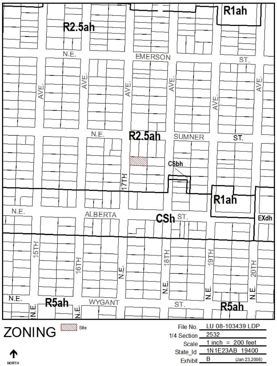
1 City of Portland Bureau of Development Services Land Use Services Division 1900 SW Fourth Ave. Suite 5000 Portland, Oregon Telephone: TDD: FAX: Date: April 29, 2008 To: From: Interested Person Mieke Stekelenburg, Land Use Services / Mieke.Stekelenburg@ci.portland.or.us NOTICE OF A TYPE I DECISION ON A PROPOSAL IN YOUR NEIGHBORHOOD The Bureau of Development Services has approved a proposal in your neighborhood. The reasons for the decision are included in this notice. If you disagree with the decision, you can appeal it to the Oregon Land Use Board of Appeals (LUBA) at 550 Capitol St. NE, Suite 235, Salem, OR The phone number for LUBA is Information on how to appeal this decision is listed at the end of this notice. CASE FILE NUMBER: LU LDP GENERAL INFORMATION Applicant: Kevin Partain Owner: Dan Andrew Urban Visions 3439 NE Sandy Blvd. # NE 56th Ave Portland, OR Portland, OR Legal Description: LOT 3 BLOCK 27, VERNON Tax Account No.: R State ID No.: 1N1E23AB Quarter Section: 2532 Neighborhood: Vernon, contact John Fall at Business District: North-Northeast Business Assoc, contact Joyce Taylor at District Coalition: Northeast Coalition of Neighborhoods, contact Robin Denburg at Zoning: R2.5ah Single Dwelling Residential 2,500 with an a overlay for Alternative Density Design and a h overlay for Aircraft Landidng zone Case Type: LDP Land Division Partition Procedure: Type I, an administrative decision with appeal to the Oregon Land Use Board of Appeals (LUBA). Proposal: The applicant is proposing a 2-parcel partition on a site that contains approximately 5,000 square feet of site area. The site is currently vacant of structures, and there are no tree preservation requirements. The applicant plans to divide the site into 2-2,500 square foot parcels for attached housing development. Narrow lot standards of Section apply. Relevant Approval Criteria: The relevant criteria are found in Section , Approval Criteria for Land Divisions in Open Space and Residential Zones.

2 Decision Notice for LU LDP Page 2 This partition is reviewed through a Type I land use review because: (1) the site is in a residential zone; (2) fewer than four lots are proposed; (3) none of the lots, utilities, or services are proposed within a Potential Landslide Hazard or Flood Hazard Area, and; (4) no other concurrent land use reviews (such as an Adjustment, Design Review, or Environmental Review) are requested or required (see ). ANALYSIS Site and Vicinity: The subject property and surrounding area is relatively flat and surrounded by residential housing development of varying type, size and age, as well as commercial development in close proximity. The site is approximately 150 north of NE Alberta Street, which is zoned CSh. This zoning designation allows for commercial development, a more intense use then what is permitted in the neighboring R2.5 zone. In addition, multifamily development abuts the property to the north, while multifamily zoning (R1) exists just two blocks east. Zoning: The R2.5 designation is one of the City s single-dwelling zones, which is intended to preserve land for housing and to promote housing opportunities for individual households. The zone implements the comprehensive plan policies and designations for single-dwelling housing. The a overlay is intended to allow increased density that meets design compatibility requirements. It focuses development on vacant sites, preserves existing housing stock, and encourages new development that is compatible with the surrounding residential neighborhood. The Aircraft Landing ( h ) overlay zone provides safer operating conditions for aircraft in the vicinity of Portland International Airport by limiting the height of structures and vegetation. The allowed height limit for buildings and vegetation on the site per the h overlay is feet above the lowest base point at Portland International Airport. The airport low base point is at an elevation of 18.3 feet. Therefore, the topographical elevation of the site PLUS the proposed building cannot exceed feet. The highest ground elevation on the site is approximately 230 feet. Therefore, buildings and vegetation on the site cannot exceed 28.3 feet in height. The maximum height limitation of the R2.5 zone is 35 feet, with the height limitation for narrow lots at approximately 30. The FAA regulates these guidelines. A letter of approval must accompany an application for a building permit where the structure will exceed the Aircraft Landing zone height limit from the Federal Aviation Administration. The application for FAA approval may be obtained from the Aviation Department of the Port of Portland. Land Use History: City records indicate there are no prior land use reviews for this site. Agency and Neighborhood Review: A Notice of Proposal in your Neighborhood was mailed on March 7, Agency Review: Several Bureaus and agencies have responded to this proposal. Please see Exhibits E for details. The comments are addressed under the appropriate criteria for review of the proposal. 2. Neighborhood Review: One written response was received from the neighboring property in the area in response to the proposal. The neighbor responded with the following concerns: Concern that the overall safety of the neighborhood will decrease due to an increase in traffic from the new development; Believes that NE 17 th Ave is overdeveloped with duplex and multi-family residential buildings; Concern over the lack of off-street parking.

3 Decision Notice for LU LDP Page 3 Staff Response: The Bureau of Development Services appreciates the submitted comments and concerns. The applicant has met, or can meet with conditions, the requirements of Code Section , which allows for the creation of two new narrow lots in the R2.5 zone, for single family attached housing. The applicant is proposing two off-street parking spaces for the new development (Exhibits C-3). Please see Sections K Transportation impacts of this report for more information on traffic impacts from the proposed land division. APPROVAL CRITERIA APPROVAL CRITERIA FOR LAND DIVISIONS IN OPEN SPACE AND RESIDENTIAL ZONES THE Preliminary Plan for a land division will be approved if the review body finds that the applicant has shown that all of the following approval criteria have been met. The relevant criteria are found in Section [A-L], Approval Criteria for Land Divisions in Open Space and Residential Zones. Due to the specific location of this site, and the nature of the proposal, some of the criteria are not applicable. The following table summarizes the applicability of each criterion. Criterion Code Topic Applicability Findings Chapter A Lots Applicable - See findings below B Trees Not applicable - No significant trees or trees in excess of 6 inches in diameter located fully on the site. C Flood Hazard Area Not applicable - The site is not within the flood hazard area. D Potential Landslide Hazard Area Not applicable - The site is not within the potential landslide hazard area. E Phased Land Division or Staged Final Plat Not applicable - A phased land division or staged final plat has not been proposed. F Recreation Area Not applicable - This is not required where the proposed density is less than 40 units G Clearing and Applicable - See findings below..100 Grading G Land Applicable - See findings below..200 Suitability H Tracts and Applicable See findings below. Easements I Solar Access Not Applicable - All of the proposed parcels are interior lots (not on a corner). In this context, solar access standards express no lot configuration preference. J Streams, Springs, and Seeps K Transportation Impacts L Services and Utilities Applicable Approval Criteria are: Not applicable - No streams, springs, or seeps are evident on the site. Applicable - See findings below Applicable - See findings below

4 Decision Notice for LU LDP Page 4 A. Lots. The standards and approval criteria of Chapters through must be met. Findings: Chapter contains the density and lot standards applicable in the R2.5 zone. These density and lot dimension standards ensure that lots are consistent with the desired character of each zone while allowing lots to vary in size and shape provided the planned intensity of each zone is respected. Density Standards Density standards match housing density with the availability of services and with the carrying capacity of the land in order to promote efficient use of land, and maximize the benefits to the public from investment in infrastructure and services. These standards promote development opportunities for housing and promote urban densities in less developed areas. Maximum densities ensure that the number of lots created does not exceed the intensity planned for the area, given the base zone, overlay zone, and plan district regulations. Minimum densities ensure that enough dwelling units can be developed to accommodate the projected need for housing. The method used to calculate density depends on whether a street is created as part of the land division, and whether the site is subject to certain environmental constraints. In this case, a street is not proposed or required, and the site is not within the environmental zone, potential landslide hazard area, or flood hazard area. Therefore, the maximum and minimum density for this site is as follows: Minimum = (5,000 square feet *.80) 5,000 square feet = 0.8 (which rounds up to a minimum of 1 lots, per A) Maximum = 5,000 square feet 2,500 square feet = 2 The applicant is proposing 2 lots. The density standards are therefore met. Lot Dimensions The lot dimension standards ensure that: (1) each lot has enough room for a reasonablysized house and garage; (2) lots are of a size and shape that development on each lot can meet the development standards of the Zoning Code; (3) lots are not too large relative to the planned density; (4) each lot has room for at least a small, private outdoor area; (5) lots are compatible with existing lots; (6) lots are wide enough to allow development to orient toward the street; (7) lots don t narrow to an unbuildable width close to the street; (8) each lot has adequate access from the street; (9) each lot has access for utilities and services; and (10) lots are not landlocked. The dimensions of the proposed lots as compared to the required lot dimension standards is shown in the following table (this information is found in Chapter of the Zoning Code): R2.5 Zone Proposed Parcel 1 Proposed Parcel 2 Requirement Minimum Lot Area 1,600 sq. ft. 2,500 2,500 Maximum Lot Area NA Minimum Lot Width* 36 ft Minimum Lot Depth 40 ft Minimum Front Lot Line 30 ft * Width is measured at the minimum front building setback line Narrow Lots

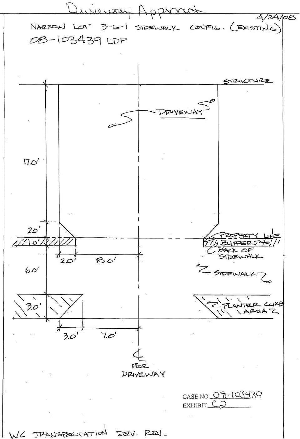
5 Decision Notice for LU LDP Page 5 Parcels 1 and 2 are 25 feet wide narrower than the standard minimum width for the R2.5 zone, as shown in the table above. Section C of the Zoning Code, however, allows narrower lots if the future development can meet certain standards: If the lot abuts an alley, then vehicle access is allowed only from the alley; If the lot does not have vehicle access from an alley, then there must be at least 15 contiguous feet of uninterrupted curb space on the abutting street for each lot being created under these provisions (lots that abut a pedestrian connection or common green are exempt from this standard). Lots must be configured so that at the time of development the length of the garage wall will be no more than 50% of the length of the street-facing building façade. Lots that will be developed with attached houses must be configured so that 60 percent of the area between the front lot line and the front building line can be landscaped at the time of development; When a driveway is proposed to provide vehicle access to more than two lots, it must be an alley; and The applicant has demonstrated that Parcels 1-2 can meet the narrow lot standards for the following reasons: Preserves on-street parking Exhibit C-2 shows that 15-feet of uninterrupted curb space will be preserved for every narrow lot along NE 17 th Avenue after provision of driveways serving the lots (including the required 3 - foot curb returns on either side of the driveway entrance). A condition of approval is required to assure that this curb space will continue to be preserved when the lots are developed or re-developed. In order to maintain the required 15 of uninterrupted curb space, the applicant is proposing an attached driveway approach for the proposed development. An adequately sized reciprocal access easement is required for the portion of the driveway that will allow shared vehicle access for the shared portion of the driveway. 50 percent garage wall limitation The applicant has demonstrated, with Exhibit C-3 that each lot will be able to accommodate a garage that will occupy no more than 50 percent of the length of the street-facing building wall. G. Clearing, Grading and Land Suitability. The approval criteria of Chapter , Clearing, Grading and Land Suitability must be met. The approval criteria of Chapter are found in two groups clearing and grading, and land suitability Clearing and Grading A. Existing contours and drainage patterns of the site must be left intact wherever practicable. Where alteration to existing drainage patterns is proposed, it must not adversely impact adjacent properties by significantly increasing volume of runoff or erosion; B. Clearing and grading should be sufficient for construction of development shown on the Preliminary Clearing and Grading Plan; C. Clearing and grading should be limited to areas of the site that are reasonably necessary for construction of development shown on the Preliminary Clearing and Grading Plan; D. Topsoil must be preserved on site to the extent practicable for use on the site after grading is complete; and
.")
6 Decision Notice for LU LDP Page 6 E. Soil stockpiles must be kept on the site and located in areas designated for clearing and grading as much as is practicable. Findings: The regulations of Chapter ensure that the proposed clearing and grading is reasonable given the infrastructure needs, site conditions, tree preservation requirements, and limit the impacts of erosion and sedimentation to help protect water quality and aquatic habitat. In this case the site is primarily flat, and is not located within the Potential Landslide Hazard Area. Therefore, no significant clearing or grading will be required on the site to make the new lots developable. In addition, there are no trees required to be preserved. This criterion is met Land Suitability Where geologic conditions or historic uses of the site indicate a hazard may exist, the applicant must show that the proposed land division will result in lots that are suitable for development. The applicant may be required to make specific improvements in order to make the lots suitable for their intended uses and the provision of services and utilities. The site is currently in residential use, and there is no record of any other use in the past. As indicated above, the site is relatively flat and contains no known geological hazards. Therefore, there are no anticipated land suitability issues and the new lots can be considered suitable for new development. This criterion is met. H. Tracts and easements. The standards of Chapter , Tracts and Easements must be met; Requirements for Tracts and Easements A. Ownership of tracts. Tracts must be owned as follows unless otherwise specified in this Title or the land use decision: 1. The owners of property served by the tract, or by any other individual or group of people. When the tract is owned by more than one person it must be held in common with an undivided interest; 2. The Homeowners Association for the area served by the tract; 3. A public or private non-profit organization; or 4. The City or other jurisdiction. Findings: No tracts are proposed or required for this land division, so criterion A does not apply. B. Maintenance agreement. The applicant must record with the County Recorder a maintenance agreement that commits the owners or owners designee to maintain all elements of the tract or easement; however, facilities within the tract or easement that will be maintained by a specified City agency may be recorded in a separate maintenance agreement. The maintenance agreement must be approved by BDS and the City Attorney in advance of Final Plat approval and must be submitted to the County Recorder to be recorded with the Final Plat. For a Planned Development not done in conjunction with a land division, the maintenance agreement must be submitted to the County Recorder to be recorded prior to issuance of the first building permit related to the development. Findings: The following easements are required for this land division: A Reciprocal Access Easement is proposed to allow shared use of a driveway that will straddle proposed lot lines. The access easement shall allowed shared access for all of the uses that driveways are intended for.

7 Decision Notice for LU LDP Page 7 As stated in Section of the Zoning Code, a maintenance agreement(s) will be required describing maintenance responsibilities for the easement described above and facilities within those areas. This criterion can be met with the condition that a maintenance agreement is prepared and recorded with the final plat. In addition, the plat must reference the recorded maintenance agreement with a recording block, substantially similar to the following example: A Declaration of Maintenance agreement for the reciprocal access easement has been recorded as document no., Multnomah County Deed Records. With the conditions of approval discussed above, this criterion is met. K. Transportation impacts. The approval criteria of Chapter , Transportation Impacts, must be met; and, The relevant approval criteria of Chapter are found in the two paragraphs below The transportation system must be capable of safely supporting the proposed development in addition to the existing uses in the area. Evaluation factors include: street capacity and level-of-service; vehicle access and loading; onstreet parking impacts; the availability of transit service and facilities and connections to transit; impacts on the immediate and adjacent neighborhoods; and safety for all modes The applicant may meet the criterion in Section , above, by including mitigation measures as part of the land division proposal. Mitigation measures must be acceptable to the City Engineer and may include providing transportation demand management measures, an access management plan, constructing streets or bicycle, pedestrian, or transit facilities on or off the site or other capital improvement projects such as traffic calming devices. Findings: The regulations of Chapter allow the traffic impacts caused by dividing and then developing land to be identified, evaluated, and mitigated for if necessary. Small land divisions involving only a few dwelling units may not require a formal transportation impact study, while it might be required for larger projects (Title 17 includes technical standards describing when a more formal study is required). The site has approximately 50 feet of frontage on NE 17 th Ave. NE 17 th Ave is classified as a local service street for all modes in the Transportation System Plan. Tri-Met provides transit service approximately 360 feet from the site on the corner of NE Alberta and NE 18 th Ave via bus 72. Parking is currently observed on NE 17 th Ave, on both sides. The site is vacant, and there are no existing off-street parking spaces on the site. A neighboring property owner is concerned that over the lack of available on-street parking. Of street parking is not required for housing that is within 500 feet of frequent service bus service. However, the applicant is proposing off street parking for each of the two proposed units. NE 17 th Ave is fully improved with a paved roadway, curbs, planting strips, and sidewalks. In reviewing this land division, Portland Transportation relies on accepted civil and traffic engineering standards and specifications to determine if existing street improvements for motor vehicles, pedestrians and bicyclists can safely and efficiently serve the proposed new development. Portland Transportation has not identified or been made aware of any factors related to this proposal that lead to a conclusion other than that two additional dwellings can be safely served by this existing street without having any significant impact on the level of service provided. The proposed combined driveway approach width of 14-feet does not meet the City recommendation for minimal attached approach widths. However, the proposed 14 width with 3 wings on each side can be approved with the following conditions. Transition to the full 20-foot wide driveway will begin at the back of the property line. The transition to the

8 Decision Notice for LU LDP Page 8 20 width shall be at a ratio of 1 of length for each 1 of width. This will require a 2 transition from the back of the sidewalk to the full 20 wide driveway. This 2 transition combined with the 17 driveway length will require the building to be setback a minimum of 19 from the back of the sidewalk, as shown in Exhibit C.2. This criterion is met, with the condition that construction of approach and driveway and reconstruction of damaged sidewalks will be a condition at time of site development. L. Services and utilities. The regulations and criteria of Chapters through , which address services and utilities, must be met. Findings: Chapters through address water service standards, sanitary sewer disposal standards, stormwater management, utilities and rights of way. The water standards of have been verified. An existing 8-inch water main is available in NE 17 th Ave. Water is available to serve the proposed development from the water main in NE 17 th Ave. See Exhibit E-3 for more details. The sanitary sewer standards of have been verified. There is an existing 8-inch combined public sanitary sewer located in NE 17 th Ave that can serve the sanitary needs of the proposed lots. See Exhibit E-1 for more details. The technical standards of Chapter related to stormwater management have been verified. The findings below for the Stormwater Management Approval Criteria of incorporate a discussion of how the technical standards have been satisfied by the applicant's stormwater proposal Stormwater Management Approval Criteria A. If a stormwater tract is proposed or required, an adequate amount of land and an appropriate location must be designated on the Preliminary Plan; and B. The application must show that a stormwater management system can be designed that will provide adequate capacity for the expected amount of stormwater. Findings: No stormwater tract is proposed or required. Therefore, criterion A is not applicable. The City of Portland requires that stormwater from development be cleaned and disposed of in a manner that meets the requirements of the City's Stormwater Management Manual. In order to meet this approval criterion, land division proposals must demonstrate an approved method of cleaning (water quality treatment), detention (delayed release), and an approved disposal point. The Stormwater Management Manual contains a hierarchy of acceptable methods of stormwater treatment and disposal. The hierarchy requires that applicants first explore the use of methods that have a lower potential impact on groundwater, such as on-site surface infiltration swales and infiltration planters. If these methods are not feasible on a site, applicants may move lower on the hierarchy, to methods that inject water deeper into the ground through mechanical devices such as drywells or sumps, or carry it off of the site into storm sewers, drainageways, or other approved disposal points. In addition to determining appropriate treatment and disposal methods by working through the hierarchy in the Stormwater Management Manual, stormwater facilities must be sized, through engineering calculations, to accommodate the expected amounts of stormwater. In some cases, sizing a stormwater facility necessitates testing the infiltration rate of the soil at the site.

9 Decision Notice for LU LDP Page 9 The applicant has proposed the following stormwater management methods (Exhibit C-1), and the Bureaus have responded as follows (Exhibits E-1 and E-5) Parcels 1 and 2: Stormwater from these lots will be directed to individual drywells that will treat the water and slowly infiltrate it into the ground. Each of these lots has sufficient area for a stormwater facility that can be adequately sized and located to meet setback standards, and accommodate water from a reasonably sized home. Site Development has indicated conceptual approval of the drywells. However, to assure that an adequate area for the drywell for the new house is retained when the lot is developed, Site Development has recommended a minimum 15- foot front or rear building setback for Parcels 1 and 2 to accommodate the drywells. With the conditions of approval described above, the stormwater management criteria are met. As shown by the findings above, the Services and Utilities criteria are met. Right of Way Approval Criteria Chapter contains standards and approval criteria for rights of way. Due to the location of this site, and the type of street that is proposed, some of the criteria are not applicable. The following table summarizes the applicability of each criterion. Code Section Topic Applicability Findings B.1 Through streets Applicable - See findings below and pedestrian connections A Utilities Applicable - See findings below. Applicable Approval Criteria are: B.1 Approval criterion for through streets and pedestrian connections in OS, R, C, and E Zones. In OS, R, C, and E zones, through streets and pedestrian connections are required where appropriate and practicable, taking the following into consideration: a. Through streets should generally be provided no more than 530 feet apart, and pedestrian connections should generally be provided no more than 330 feet apart. Through street and pedestrian connections should generally be at least 200 feet apart; b. Where the street pattern in the area immediately surrounding the site meets the spacing of subparagraph a., above, the existing street pattern should be extended onto the site; c. Characteristics of the site, adjacent sites, and vicinity, such as: (1) Terrain; (2) Whether adjacent sites may be further divided; (3) The location of existing streets and pedestrian connections; (4) Whether narrow frontages will constrain creation of a through street or pedestrian connection; (5) Whether environmental overlay zones interrupt the expected path of a through street or pedestrian connection; and (6) Whether existing dwelling units on- or off-site obstruct the expected path of a through street or pedestrian connection. Alternative locations or designs of rights-of-way should be considered that avoid existing dwelling units. However, provision of through streets or pedestrian connections should take precedence over protection of existing dwelling units where the surrounding transportation system will be significantly affected if a new through street or pedestrian connection is not created; d. Master street plans for the area identified in Goal 11B of the Comprehensive Plan;

10 Decision Notice for LU LDP Page 10 e. Pedestrian connections should take the most direct route practicable. Users should be able to see the ending of the connection from the entrance point, if possible. Findings: The site is located between NE Sumner Street and NE Alberta which have a distance between them of approximately 400 feet. There are no other east-west through streets between these two streets. If the distance between these existing streets is evaluated against the optimum spacing requirement of 530 feet, one can conclude that there should not be an east-west through street provided in the vicinity of the site. In addition, the site is not within an area that has an adopted Master Street Plan, so criterion d. does not apply. The frontage of the site is fully improved with curbs, sidewalk and planting strip. For the reasons described above, this criterion is met. Utility Location, Extension of Streets, Partial Rights of Way Additional Approval Criteria for Rights-of-Way A. Utilities. Utilities must be located within rights-of-way or utility easements that are adjacent to rights-of-way to the maximum extent practicable. Utility easements up to 15 feet in width may be required adjacent to rights-of-way. Findings: Any easements that may be needed for private utilities that cannot be accommodated within the existing right-of-way can be provided on the final plat. At this time no specific utility easements adjacent to the right-of-way have been identified as being necessary. Therefore, this criterion is met. DEVELOPMENT STANDARDS General Information about Development Standards and Approval Criteria. The Zoning Code contains two types of regulations: Development standards and Approval criteria. Approval criteria, such as those listed earlier in this report, are administered through a land use review process. Approval criteria are regulations where the decision-maker must exercise discretion to determine if the regulation is met. Public notice is provided and public comments received that address the approval criteria are addressed in the decision. Development Standards: Development standards are clear and objective regulations (for example: building setbacks; number of required parking spaces; and maximum floor area). Compliance with development standards is reviewed as part of the administrative permitting process and not considered to be discretionary reviews. Development standards that are not relevant to the land division review, have not been addressed in the review, but will have to be met at the time that each of the proposed lots is developed. Among the various development standards that will be applicable to this lot, the applicant should take note of: Narrow Lots-- development on Parcels 1 and 2 will be subject to the following standards at the time of development permitting: Height of the structures will be limited to 1.5 times the width of the structure, per B.2; and Garages can be no wider than 50% of the width of the front façade of the house, per E.4.c (1) Landscaping Standards: 60% of the area between the front lot line and the building line must be landscaped per C.d.

11 Decision Notice for LU LDP Page 11 Existing development that will not remain after the land division. The site is currently vacant, so the division of the property will not cause the structures to move out of conformance or further out of conformance with any development standard applicable in the R2.5 zone. Therefore, this land division proposal can meet the requirements of With the conditions noted above, this land division proposal can meet the requirements of OTHER TECHNICAL REQUIREMENTS Technical decisions have been made as part of this review process. These decisions have been made based on other City Titles, adopted technical manuals, and the technical expertise of appropriate service agencies. These related technical decisions are not considered land use actions. If future technical decisions result in changes that bring the project out of conformance with this land use decision, a new land use review may be required. The following is a summary of technical service standards applicable to this preliminary partition proposal. Bureau Code Authority Topic Water Works Title 21 Water availability Environmental Services Title 17; 2002 Stormwater Manual Fire Bureau Title 31 Policy B-1 Transportation Title 17, Transportation System Plan Development Titles 24 27, Services Admin Rules for Private Rights of Way Sewer availability Stormwater Management Emergency Access Design of public street Building Code, Erosion Control, Flood plain, Site Development & Private Streets Contact Information As authorized in Section of the Zoning Code conditions of approval related to these technical standards have been included in the Administrative Decision on this proposal. The applicant must meet the requirements of the Fire Bureau in regards to building height measured to the eave of the structure and must be less than 30 feet in height. These requirements are based on the technical standards of Title 31 and the Fire Code. CONCLUSIONS The applicant has proposed a 2- parcel partition, as shown on the attached preliminary plan (Exhibit C-1). As discussed in this report, the relevant standards and approval criteria have been met, or can be met with conditions. The primary issues identified with this proposal are: Narrow lot standards Fire Bureau requirements for building height Shared driveway construction and reciprocal access easement. With conditions of approval that address these requirements this proposal can be approved.

12 Decision Notice for LU LDP Page 12 ADMINISTRATIVE DECISION Approval of a Preliminary Plan for a 2-lot partition, that will result in two narrow lots as illustrated with Exhibit C1, subject to the following conditions: A. The final plat must show the following: 1. A Private Reciprocal Access Easement shall be shown and labeled on the final plat, centered on the common property line between Parcel 1 and Parcel 2. The easement shall allow shared use of the driveway area for all of the purposes that a driveway would be typically used for. 2. A recording block for the maintenance agreement described below. The recording block shall, at a minimum, include language substantially similar to the following example: A Declaration of Maintenance Agreement for Private Reciprocal Access Easement has been recorded as document no., Multnomah County Deed Records. C. The following must occur prior to Final Plat approval: Required Legal Documents 1. A Maintenance Agreement shall be executed for the Reciprocal Access Easement area described in Condition B1 above. The agreement shall include provisions assigning maintenance responsibilities for the easement area and any shared facilities within that area, consistent with the purpose of the easement, and all applicable City Code standards. The agreement must be reviewed by the City Attorney and the Bureau of Development Services, and approved as to form, prior to final plat approval. D. The following conditions are applicable to site preparation and the development of individual lots: 1. A minimum of 15 feet of uninterrupted curb space for each lot must be preserved along the frontage of parcels 1 and The applicant must provide aerial fire accessway to the satisfaction of the Fire Bureau or the height of the new structures shall be limited to 30 feet, measured to the eave. 3. The minimum front or rear building setback for Parcels 1 and 2 shall be 15 feet to assure that adequate space is available to accommodate a stormwater disposal facility that can comply with the requirements of the Stormwater Management Manual. Decision rendered by: on (April 24, 2008 By authority of the Director of the Bureau of Development Services Decision mailed April 29, 2008 Staff Planner: Mieke Stekelenburg About this Decision. This land use decision is not a permit for development. A Final Plat must be completed and recorded before the proposed lots can be sold or developed. Permits may be required prior to any work. Contact the Development Services Center at for information about permits. Procedural Information. The application for this land use review was submitted on January 18, 2008, and was determined to be complete on February 29, Zoning Code Section states that Land Use Review applications are reviewed under the regulations in effect at the time the application was submitted, provided that the

13 Decision Notice for LU LDP Page 13 application is complete at the time of submittal, or complete within 180 days. Therefore this application was reviewed against the Zoning Code in effect on January 18, ORS states the City must issue a final decision on Land Use Review applications within 120-days of the application being deemed complete. The 120-day review period may be waived or extended at the request of the applicant. In this case, the applicant did not waive or extend the 120-day review period. Some of the information contained in this report was provided by the applicant. As required by Section of the Portland Zoning Code, the burden of proof is on the applicant to show that the approval criteria are met. The Bureau of Development Services has independently reviewed the information submitted by the applicant and has included this information only where the Bureau of Development Services has determined the information satisfactorily demonstrates compliance with the applicable approval criteria. This report is the decision of the Bureau of Development Services with input from other City and public agencies. Conditions of Approval. If approved, this project may be subject to a number of specific conditions, listed above. Compliance with the applicable conditions of approval must be documented in all related permit applications. Plans and drawings submitted during the permitting process must illustrate how applicable conditions of approval are met. Any project elements that are specifically required by conditions of approval must be shown on the plans, and labeled as such. These conditions of approval run with the land, unless modified by future land use reviews. As used in the conditions, the term applicant includes the applicant for this land use review, any person undertaking development pursuant to this land use review, the proprietor of the use or development approved by this land use review, and the current owner and future owners of the property subject to this land use review. This decision, and any conditions associated with it, is final. It may be appealed to the Oregon Land Use Board of Appeals (LUBA), within 21 days of the date the decision is mailed, as specified in the Oregon Revised Statute (ORS) Among other things, ORS requires that a petitioner at LUBA must have submitted written testimony during the comment period for this land use review. You may call LUBA at for further information on filing an appeal. The file and all evidence on this case are available for your review by appointment. Please contact the receptionist at to schedule an appointment. Copies of all information in the file can be obtained for a fee equal to the cost for such services. You may also find additional information about the City of Portland and City Bureaus, as well as a digital copy of the Portland Zoning Code, by visiting the City s homepage on the Internet at Recording the land division. The final land division plat must be submitted to the City within three years of the date of the City s final approval of the preliminary plan. This final plat must be recorded with the County Recorder and Assessors Office after it is signed by the Planning Director or delegate, the City Engineer, and the City Land Use Hearings Officer, and approved by the County Surveyor. The approved preliminary plan will expire unless a final plat is submitted within three years of the date of the City s approval of the preliminary plan. EXHIBITS NOT ATTACHED UNLESS INDICATED A. Applicant s Statement B. Zoning Map (attached) C. Plans/Drawings: 1. Site Plan (attached) 2. Driveway Approach (attached) 3. Conceptual front building façade(attached)

14 Decision Notice for LU LDP Page 14 D. Notification information: 1. Mailing list 2. Mailed notice E. Agency Responses: 1. Bureau of Environmental Services 2. Bureau of Transportation Engineering and Development Review 3. Water Bureau 4. Fire Bureau 5. Site Development Review Section of BDS 6. Bureau of Parks, Forestry Division F. Correspondence: 1. Layla Schubert, 211 Briarcliff Drive. Apt. #2 Eugene, Oregon G. Other: 1. Original LU Application The Bureau of Development Services is committed to providing equal access to information and hearings. If you need special accommodations, please call (TTY ).

15
16

17
18

NOTICE OF A TYPE Ix DECISION ON A PROPOSAL IN YOUR NEIGHBORHOOD
 Date: June 29, 2016 To: From: Interested Person Susan Ellis, Land Use Services 503-823-5361 / susan.ellis@portlandoregon.gov NOTICE OF A TYPE Ix DECISION ON A PROPOSAL IN YOUR NEIGHBORHOOD The Bureau of
NOTICE OF A TYPE Ix DECISION ON A PROPOSAL IN YOUR NEIGHBORHOOD
 Date: October 28, 2013 To: Interested Person From: Kathy Harnden, Land Use Services 503-823-7318 / Kathy.Harnden@portlandoregon.gov NOTICE OF A TYPE Ix DECISION ON A PROPOSAL IN YOUR NEIGHBORHOOD The Bureau
WESTFIELD-WASHINGTON ADVISORY PLAN COMMISSION December 7, 2015 1512-SPP-24 & 1512-ODP-24
 Petition Number: Subject Site Address: Petitioner: Request: East side of Oak Road, north of 151 st Street Langston Development Co. Primary Plat and Overall Development Plan amendment review for Mapleridge
HEARINGS OFFICE DECISION OF THE HEARINGS OFFICER. File No.: LU 08-125814 LDS ENM - Rubicon 2 (HO 4090005)
") CITY OF PORTLAND, OREGON HEARINGS OFFICE 1900 S.W. 4 th Avenue, Room 3100 Portland, Oregon 97201 Telephone: (503) 823-7307 FAX: (503) 823-4347 TDD (503) 823-6868 www.portlandonline.com/auditor/hearings
CITY OF PORTLAND, OREGON HEARINGS OFFICE 1900 S.W. 4 th Avenue, Room 3100 Portland, Oregon 97201 Telephone: (503) 823-7307 FAX: (503) 823-4347 TDD (503) 823-6868 www.portlandonline.com/auditor/hearings
d. Building permits may only be approved if consistent with the approved development plan and land division for all units with common walls.
 Section 20.920.060 Tier 2 Infill Standards. In addition to the Tier 1 standards and incentives, Tier 2 infill parcels and land divisions and the subsequent development on those Tier 2 infill parcels shall
PLANNED UNIT DEVELOPMENT & SIDEWALK WAIVER REQUEST STAFF REPORT Date: November 7, 2013
 PLANNED UNIT DEVELOPMENT & SIDEWALK WAIVER REQUEST STAFF REPORT Date: November 7, 2013 NAME LOCATION Audubon Properties, LLC. 4700 & 4960 Dauphin Island Parkway West side of Dauphin Island Parkway, 580
Kirkland Zoning Code 113.25
 Kirkland Zoning Code 113.25 Chapter 113 COTTAGE, CARRIAGE AND TWO/THREE-UNIT HOMES Sections: 113.05 User Guide 113.10 Voluntary Provisions and Intent 113.15 Housing Types Defined 113.20 Applicable Use
NOTICE OF A TYPE II DECISION ON A PROPOSAL IN YOUR NEIGHBORHOOD
 Date: July 17, 2009 To: From: Interested Person Kathleen Stokes, Land Use Services 503-823-7843 / kstokes@ci.portland.or.us NOTICE OF A TYPE II DECISION ON A PROPOSAL IN YOUR NEIGHBORHOOD The Bureau of
City of Colleyville Community Development Department. Site/Landscape Plan Application Packet
 City of Colleyville Community Development Department Site/Landscape Plan Application Packet Development Application Fees City of Colleyville 100 Main Street Colleyville TX 76034 817.503.1050 Zoning Zoning
Section 801 Driveway Access Onto Public Right-of-Ways
 Section 801:00 Section 801 Driveway Access Onto Public Right-of-Ways Section 801:00. Definitions. The following words and terms, when used in this Article, shall have the following meanings, unless the
County of San Diego, Planning & Development Services SECOND DWELLING UNIT
 County of San Diego, Planning & Development Services ZONING DIVISION The Zoning Ordinance, Section 6156.x, allows the addition of a second dwelling unit to those properties zoned to allow the Family Residential
City of Valdosta Land Development Regulations. Table of Contents
 TITLE 1 ADMINISTRATION Chapter 102 General Provisions 102-1 Title 102-2 Purpose 102-3 Authority 102-4 Jurisdiction 102-5 Application of Ordinance 102-6 Relationship to Existing Ordinances 102-7 Powers
INTRODUCTION TO ZONING DISTRICT REGULATIONS
 INTRODUCTION TO ZONING DISTRICT REGULATIONS Classification of Zoning Districts Zoning districts in Dorchester County are categorized as Suburban Urban, Suburban Transition, or Rural. These districts are
How To Amend A Stormwater Ordinance
 Regulatory Alternatives to Address Stormwater Management and Flooding in the Marlboro Street Study Area Alternative 1: Amend Existing Local Regulations This proposed alternative provides an incremental
Planning and Zoning Commission Johnston, Iowa June 29, 2015
 ITEM NO. 15-19 Planning and Zoning Commission Johnston, Iowa June 29, 2015 SUBJECT: Consider recommending approval of the Final Plat for Crosshaven Plat 6 subdividing 28.28 acres into 47 single family
Division 51-4.400. Yard, Lot, and Space Regulations.
 Division 51-4.400. Yard, Lot, and Space Regulations. SEC. 51-4.401. MINIMUM FRONT YARD. (a) General provisions. (1) Required front yards must be open and unobstructed except for fences. Except as otherwise
CPED STAFF REPORT Prepared for the City Planning Commission
 CPED STAFF REPORT Prepared for the City Planning Commission CPC Agenda Item #1 June 23, 2014 RLS-72 LAND USE APPLICATION SUMMARY Property Location: 222 Hennepin Avenue Project Name: 222 Prepared By: Becca
Minor Accommodation Planning Review Application
 City of Beverly Hills Planning Division 455 N. Rexford Drive Beverly Hills, CA 90210 Tel. (310) 285 1141 Fax. (310) 858 5966 Planning Review Overview: Minor Accommodation Planning Review Application Before
http://www.parkcity.org/government/codesandpolicies/title_15_c_2_4.html
 1 of 8 8/28/2007 12:31 PM Visitors Residents Business Government City Departments Online Services ParkCity.org > Government > Codesandpolicies Land Management Code Municipal Code Sign Code Construction
D3 April 8, 2015 Public Hearing
 D3 April 8, 2015 Public Hearing APPLICANT AND PROPERTY OWNER: ASSEMBLY OF YAH, INC. STAFF PLANNER: Kevin Kemp REQUEST: Conditional Use Permit (Religious Facility - church) ADDRESS / DESCRIPTION: 5151 Locke
SITE DEVELOPMENT PLAN CHECKLIST. Project Name: Site Plan No.:
 SITE DEVELOPMENT PLAN CHECKLIST 5/12/05 Rev.3/14/06 Project Name: Site Plan No.: REVIEW CRITERIA Plans: A site development plan (signed and sealed) shall be on a 24 x 36 sheet at a scale that is no smaller
ORDINANCE NO. 2013 -
 ORDINANCE NO. 2013 - AN ORDINANCE OF BREVARD COUNTY, FLORIDA AMENDING CHAPTER 62, LAND DEVELOPMENT REGULATIONS SECTION 62-2891, LOT DRAINAGE, AND CHAPTER 22 BUILDINGS AND BUILDING REGULATIONS, SECTION
Washington City Subdivision Development Application Checklist 435-656-6325
 Application Checklist 1 Washington City Subdivision Development Application Checklist 435-656-6325 1) Wednesday Staff and Developer Meeting. *Call to schedule an appointment. A. Statement of project intent
CHAPTER 5 - "R1" SINGLE-FAMILY RESIDENTIAL DISTRICT
 CHAPTER 5 - "R1" SINGLE-FAMILY RESIDENTIAL DISTRICT Section 5-1. Regulations: The regulations set forth in this chapter, or set forth elsewhere in this ordinance when referred to in this chapter, are the
Development Variance Permit Application Package
 When do I need a Development Variance Permit? Development Variance Permit Application Package If my proposed development does not meet the standards set out in the Zoning Regulation Bylaw on matters that
Chapter 3 SENSITIVE AREAS AND VEGETATED CORRIDORS
 Chapter 3 3.01 General Provisions 3.01.1 Introduction 3.01.2 Application and Interpretation of Chapter 3.01.3 Unbuildable Lots 3.01.4 Other Permits 3.01.5 Prohibited Activities 3.02 Service Provider Letter
CITY OF VAUGHAN SCHEDULE O LOT GRADING DESIGN FOR RESIDENTIAL DEVELOPMENT
 Page 1 CITY OF VAUGHAN SCHEDULE O LOT GRADING DESIGN FOR RESIDENTIAL DEVELOPMENT CIVIC CENTRE 2141 MAJOR MACKENZIE DRIVE MAPLE ONTARIO L6A 1T1 905-832-2281 Page 2 SECTION 1 - GENERAL OBJECTIVES To provide
REQUEST FOR RESPONSE
 Date: November 6, 2014 From: Staci Monroe, Land Use Services 503-823-0624 / staci.monroe@portlandoregon.gov REQUEST FOR RESPONSE Case File: LU 14-215153 DZ Lloyd Center Remodel Pre App: PC # 14-155864
NOTICE OF A TYPE II DECISION ON A PROPOSAL IN YOUR NEIGHBORHOOD
 Date: June 29, 2016 To: From: Interested Person Andrew Gulizia, Land Use Services 503-823-7010 / Andrew.Gulizia@portlandoregon.gov NOTICE OF A TYPE II DECISION ON A PROPOSAL IN YOUR NEIGHBORHOOD The Bureau
1161.01 CONFORMITY WITH PLANS; DRAINAGE.
 CHAPTER 1161 Subdivision Requirements 1161.01 Conformity with plans; drainage 1161.07 Easements 1161.02 Trees 1161.08 Streets 1161.03 Subdivision name 1161.09 Blocks 1161.04 Street names 1161.10 Lots 1161.05
City of Douglas Commercial Building Permit Site Application
 City of Douglas Commercial Building Permit Site Application *Complete the following information including a complete site plan and floor plan. *Incomplete information may result in delay and/or rejection
RESIDENTIAL DRIVEWAYS
 RESIDENTIAL DRIVEWAYS If you have specific questions or want to confirm your plans, our staff is available to assist in person, by telephone, or by e-mail. City of St. Petersburg Division of Development
Revere Beach Transit-Oriented Development Parcels Revere, Massachusetts. Design and Development Guidelines. Part Two.
 Revere Beach Transit-Oriented Development Parcels Revere, Massachusetts Design and Development Guidelines Request for Qualifications and Expressions of Interest with Preliminary Development Plans Part
FILE NO.: Z-6915-C. Gamble Road Short-form PCD and Land Alteration Variance Request
 FILE NO.: Z-6915-C NAME: Gamble Road Short-form PCD and Land Alteration Variance Request LOCATION: Located on the Northwest corner of Chenal Parkway and Gamble Road DEVELOPER: Davis Properties P.O. Box
CITY OF ESCONDIDO Planning Division 201 North Broadway Escondido, CA 92025-2798 (760) 839-4671 Fax: (760) 839-4313 ARTS AND CRAFTS SHOW PERMIT
 839-4671 Fax: (760) 839-4313 ARTS AND CRAFTS SHOW PERMIT") CITY OF ESCONDIDO Planning Division 201 North Broadway Escondido, CA 92025-2798 (760) 839-4671 Fax: (760) 839-4313 ARTS AND CRAFTS SHOW PERMIT APPLICANT/CONTACT PERSON Name (Print): Address: City, State,
CITY OF ESCONDIDO Planning Division 201 North Broadway Escondido, CA 92025-2798 (760) 839-4671 Fax: (760) 839-4313 ARTS AND CRAFTS SHOW PERMIT APPLICANT/CONTACT PERSON Name (Print): Address: City, State,
Staff Report General Development Plan/Master Plan Aldermanic District: 1 County Commission District: 2 MPC File No. 16-000526-PLAN February 23, 2016
 Staff Report General Development Plan/Master Plan Aldermanic District: 1 County Commission District: 2 MPC File No. 16-000526-PLAN February 23, 2016 1101 Bull Street One West Park Avenue 1107 Bull Street
Rezoning case no. RZ15-08: Adam Development Properties, LP
 PLANNING AND ZONING COMMISSION STAFF REPORT June 4, 2015 Rezoning case no. RZ15-08: Adam Development Properties, LP CASE DESCRIPTION: LOCATION: a request to amend the development plan of a previously-approved
SITE PLAN REVIEW APPLICATION
 SITE PLAN REVIEW APPLICATION 405 Martin Luther King Jr. Blvd phone (919) 968-2728 fax (919) 969-2014 www.townofchapelhill.org Parcel Identifier Number (PIN): Date: Section A: Project Information Section
FILING REQUIREMENTS EXCERPTS FROM THE ZONING ORDINANCE SOLAR ENERGY SYSTEMS
 County of San Diego, Planning & Development Services APPLICANT S GUIDE FOR A SOLAR ENERGY SYSTEM ZONING DIVISION These guidelines provide information on how to apply for a Solar Energy System. Review the
ENGINEERING DESIGN GUIDELINES. for SUBDIVISIONS OR COMMERCIAL DEVELOPMENTS
 ENGINEERING DESIGN GUIDELINES for SUBDIVISIONS OR COMMERCIAL DEVELOPMENTS City of Birmingham Department of Planning, Engineering and Permits Engineering Division Office of the City Engineer 2008 TABLE
Draft Goals and Objectives Wadena Comprehensive Plan City of Wadena, Minnesota. Land Use Goals:
 Draft Goals and Objectives Wadena Comprehensive Plan City of Wadena, Minnesota Land Use Goals: 1. Growth in Wadena will be undertaken in such a manner as to create a full range of living, working, shopping,
5901 Milwaukee Street Planned Unit Development (GDP) (Second Addition to Grandview Commons)
 (Second Addition to Grandview Commons)") DATE: March 8, 2006 TO: FROM: SUBJECT: Plan Commission Larry D. Nelson, P.E., City Engineer 5901 Milwaukee Street Planned Unit Development (GDP) (Second Addition to Grandview Commons) The City Engineering
DATE: March 8, 2006 TO: FROM: SUBJECT: Plan Commission Larry D. Nelson, P.E., City Engineer 5901 Milwaukee Street Planned Unit Development (GDP) (Second Addition to Grandview Commons) The City Engineering
Title 33, Planning and Zoning Chapter 33.110 8/29/14 Single-Dwelling Zones
 Title 33, Planning and Zoning Chapter 33.110 8/29/14 Single-Dwelling Zones CHAPTER 33.110 SINGLE-DWELLING ZONES (Amended by: Ord. No.165376, effective 5/29/92; Ord. No. 165594, effective 7/8/92; Ord. No.
LAND USE CODE CHAPTER 18.68 GENERAL REGULATIONS
 CHAPTER 18.68 GENERAL REGULATIONS SECTIONS: 18.68.010 Fences. 18.68.020 Vision Clearance Area. 18.68.030 Access. 18.68.040 Yard Requirements. 18.68.050 Special Setback Requirements. 18.68.070 Land Surveys.
HIGHWAY DEPARTMENT ACCESS AND RIGHT OF WAY WIDTH GUIDELINES
 Approved 6/26/01 HIGHWAY DEPARTMENT ACCESS AND RIGHT OF WAY WIDTH GUIDELINES All new, modified and/or changed use access(es) onto county roads shall be subject to the access and corridor protection guidelines
AREA: 2.37 acres NUMBER OF LOTS: 1 FT. NEW STREET: 0 LF. Single-family, Non-conforming machine shop
 FILE NO.: Z-8958 NAME: Rock Structure Repair Short-form PID LOCATION: Located at 8024 Stanton Road DEVELOPER: Rock Structure Repair Attn. Rudy Gutierrez 3 Kipling Court Little Rock, AR 72209 ENGINEER:
City Code of ANN ARBOR, MICHIGAN Chapter 55 Zoning
 ARTICLE II. USE REGULATIONS 5:10.2. R1A, R1B, R1C, R1D single family dwelling district (1) Intent. (a) These single family residential districts are designed to provide an environment of predominantly
CASE FILE NUMBER: LU 14-155978 HR SOLAR ARRAY GENERAL INFORMATION
 Date: June 25, 2014 To: From: Interested Person Jennifer Kenny, Land Use Services 503-823-7011 / Jennifer.Kenny@portlandoregon.gov NOTICE OF A TYPE II DECISION ON A PROPOSAL IN YOUR NEIGHBORHOOD The Bureau
NOTICE OF A TYPE II DECISION ON A PROPOSAL IN YOUR NEIGHBORHOOD
 Date: May 18, 2009 To: Interested Person From: Dave Skilton, Land Use Services (503-823-0660) dave.skilton@ci.portland.or.us NOTICE OF A TYPE II DECISION ON A PROPOSAL IN YOUR NEIGHBORHOOD The Bureau of
B. Improve the appearance and character of areas surrounding new development.
 Chapter 4.3: Landscape Regulations Sections: 4.301 Purposes 4.302 Applicability 4.303 General Provisions 4.304 Landscape Maintenance 4.301 Purposes The purposes of these regulations are to: A. Promote
1. It would create hazardous effects of storm water run-off. 3. It would increase hazardous driving conditions on the public road.
 SECTION 6: REQUIREMENTS FOR A DRIVEWAY CONNECTION A. Required information. The application shall be accompanied by a sketch of the proposed driveway which at a minimum shall indicate: 1. Geometric information
Application No.: 14.074 Steve Rush, representing Rocky Mountain Power Rocky Mountain Power Project Location: approximately 1600 N. 6800 E.
 Planning Commission Staff Report Planning and Development Services Croydon Substation Conditional Use Permit Public Meeting August 28, 2014 Application No.: 14.074 Applicant: Steve Rush, representing Rocky
3.4 DRAINAGE PLAN. 3.4.1 Characteristics of Existing Drainages. 3.4.2 Master Drainage System. Section 3: Development Plan BUTTERFIELD SPECIFIC PLAN
 3.4 DRAINAGE PLAN This section describes the existing onsite drainage characteristics and improvements proposed within this Specific Plan. Following this description, drainage plan development standards
Electronic Signature and Fee Payment Confirmation
 Jeff Levine, AICP, Director Planning & Urban Development Department Electronic Signature and Fee Payment Confirmation Notice: Your electronic signature is considered a legal signature per state law. By
PRE APPLICATION CONFERENCE - INTRODUCTION
 CITY OF AUBURN Planning & Development Department Auburn City Hall Annex, 2 nd Floor 1 East Main Street Auburn, WA 98001 Tel: 253.931.3090 Fax: 253.804.3114 permitcenter@auburnwa.gov www.auburnwa.gov PRE-APPLICATION
Frequently-Asked Questions about Floodplains and Flood Insurance FLOOD INSURANCE
 Frequently-Asked Questions about Floodplains and Flood Insurance What is a floodplain? The floodplain is any area covered by water during normal water flows, and which could be inundated as a result of
Model Subdivision and Land Development (SALDO) Subdivision/ Land Development Presentation Overview. Why Subdivision and Land Development Regulations?
 Subdivision/ Land Development Presentation Overview. Why Subdivision and Land Development Regulations?") Model Subdivision and Land Development (SALDO) Subdivision/ Land Development Presentation Overview Purpose of Subdivision/ Land Development Ordinances (SALDO) Municipalities Planning Code Process Design
Model Subdivision and Land Development (SALDO) Subdivision/ Land Development Presentation Overview Purpose of Subdivision/ Land Development Ordinances (SALDO) Municipalities Planning Code Process Design
SECTION 5 DRAFTING STANDARDS
 SECTION 5 DRAFTING STANDARDS 1 SECTION FIVE TABLE OF CONTENTS Description Page TABLE OF CONTENTS... 5-2 GENERAL... 5-3 DRAFTING STANDARDS... 5-5 DRAFTING MINIMUM REQUIREMENTS HANDOUT... 5-8 2 GENERAL 1.
CLACKAMAS COUNTY ZONING AND DEVELOPMENT ORDINANCE
 1008 STORM DRAINAGE (3/24/05) 1008.01 PURPOSE To minimize the amount of stormwater runoff resulting from development utilizing nonstructural controls where possible, maintain and improve water quality,
Definition of Tower from the Bradley County Zoning Resolution
 Definition of Tower from the Bradley County Zoning Resolution 43. TOWER. Any outdoor structure designed and constructed to support one (1) or more transmitting or receiving devices for telephone, radio
28.0 Development Permit Area #2 (Neighbourhood District)
") 28.0 Development Permit Area #2 (Neighbourhood District) Goals and Objectives To provide a guide for infill and new development in the Neighbourhood District. To outline the nature, form and character
28.0 Development Permit Area #2 (Neighbourhood District) Goals and Objectives To provide a guide for infill and new development in the Neighbourhood District. To outline the nature, form and character
DOÑA ANA COUNTY DESIGN STORM CRITERIA GUIDELINES FOR COMMERCIAL AND RESIDENTIAL SITES. Run-off Analysis Methods
 DOÑA ANA COUNTY DESIGN STORM CRITERIA GUIDELINES FOR COMMERCIAL AND RESIDENTIAL SITES Run-off Analysis Methods This document sets forth the minimum design, technical criteria and specifications for the
City of Dayton, Ohio Zoning Code
 City of Dayton, Ohio Zoning Code Effective August 1, 2006 (Ord. 30515-05) Amended August 23, 2006 (Ord. 30594-06) Amended October 4, 2006 (Ord. 30602-06) Amended March 21, 2007 (Ord. 30643-07) Amended
FILE NO.: Z-8403. LOCATION: Located on the Northeast and Southeast corners of West 12 th Street and Dennison Street
 FILE NO.: Z-8403 NAME: Glason Short-form POD LOCATION: Located on the Northeast and Southeast corners of West 12 th Street and Dennison Street DEVELOPER: Dennis Glason c/o the Law Office of Simmons S.
Moving a House in Pasadena
 Moving a House in Pasadena To assist homeowners and contractors wishing to relocate a home in Pasadena, this handout summarizes the steps in the permitting process. Please keep in mind that the sequence
Land Use and Zoning. Land Use Within the Port Madison Indian Reservation
 Land Use and Zoning Land Use Within the Port Madison Indian Reservation A portion of the Suquamish Rural Village is Trust land, owned either by the Tribe or individual tribal members. The following list
BEFORE THE HEARING EXAMINER FOR THURSTON COUNTY
 BEFORE THE HEARING EXAMINER FOR THURSTON COUNTY In the Matter of the Application of ) NO. SSDP 000748 ) Kevin Robinson ) FINDINGS, CONCLUSIONS ) AND DECISION For a Shoreline Substantial Development ) Permit
VERTICAL SPEED CONTROL DEVICES
 H-3.8 VERTICAL SPEED CONTROL DEVICES GENERAL 1. Description This standard identifies minimum requirements that shall be met for all Vertical Speed Control Devices in the design and construction of elements
BEST PRACTICES. Smart Transportation is a key concept for the Paoli Roadway Improvement Project.
 Smart Transportation Smart Transportation is a key concept for the Paoli Roadway Improvement Project. PennDOT s Smart Transportation Guidebook (2008) outlines a comprehensive approach to transportation
Land Disturbance, Erosion Control and Stormwater Management Checklist. Walworth County Land Conservation Department
 Land Disturbance, Erosion Control and Stormwater Management Checklist Walworth County Land Conservation Department The following checklist is designed to assist the applicant in complying with the Walworth
APPLICATION FOR TENTATIVE MAPS
 APPLICATION FOR TENTATIVE MAPS Planning Division 38250 Sierra Highway Palmdale, CA 93550 (661) 267-5200 planningdiv@cityofpalmdale.org Tentative Case No.: Date: Received by: Print Name INSTRUCTIONS TO
COASTAL DEVELOPMENT PERMIT
 COASTAL DEVELOPMENT PERMIT ZONE CODE SECTIONS 12.20.2 prior to LCP certification. The MASTER LAND USE APPLICATION INSTRUCTION SHEET 500' RADIUS should also be followed, except that a 100-foot radius map
TOWN OF CARY CONDITIONAL USE ZONING PERMIT. 412 Rutherglen Cary, NC 27511-6437. 412 Rutherglen Cary, NC 27511-6437
 TOWN OF CARY CONDITIONAL USE ZONING PERMIT PETITION: PETITIONER(S): OWNER(S): LOCATION: 01-REZ-16 204 N. Dixon Avenue, Cary, NC PARCEL IDENTIFICATION: 076418218784 REALID: 0031004 AREA: APPROVED ZONING:
APPENDIX G. California Coastal Commission & Conservancy Accessibility Standards
 APPENDIX G California Coastal Commission & Conservancy Accessibility Standards STANDARDS AND RECOMMENDATIONS FOR ACCESSWAY LOCATION AND DEVELOPMENT These standards provide guidelines for the location,
Article 20. Nonconformities
 Article 20. Nonconformities 20.1 PURPOSE 20.2 GENERAL STANDARDS OF APPLICABILITY 20.3 NONCONFORMING USE 20.4 NONCONFORMING STRUCTURES 20.5 NONCONFORMING LOTS OF RECORD 20.6 NONCONFORMING SIGNS 20.1 PURPOSE
ELEMENT 4 - FUTURE LAND USE ELEMENT
 ELEMENT 4 - FUTURE LAND USE ELEMENT Goal 1 To create a long-range development pattern which directs growth into developable areas and away from environmentally sensitive areas, in a manner that is compatible
THE APPRAISAL OF REAL ESTATE 3 RD CANADIAN EDITION BUSI 330
 THE APPRAISAL OF REAL ESTATE 3 RD CANADIAN EDITION BUSI 330 REVIEW NOTES by CHUCK DUNN CHAPTER 10 Copyright 2010 by the Real Estate Division and Chuck Dunn. All rights reserved ARE 3 rd EDITION REVIEW
Chapter 2 PLAN AND PLAT REVIEW PROCESS
 www.cityofknoxville.org/engineering/ Chapter 2 PLAN AND PLAT REVIEW PROCESS 2.1 Overall Sequence for Large Projects The overall sequence of major development and redevelopment projects will generally follow
APPLICATION FOR SPECIAL EXCEPTION USE
 APPLICATION FOR SPECIAL EXCEPTION USE CITY OF PORT ST. LUCIE FOR OFFICE USE ONLY Planning & Zoning Department 121 SW Port ST. Lucie Blvd. Planning Dept. Port St. Lucie, Florida 34984 Fee (Nonrefundable)$
City of North Miami Beach, Florida COMMUNITY DEVELOPMENT DEPARTMENT
 City of North Miami Beach, Florida COMMUNITY DEVELOPMENT DEPARTMENT PLANNING AND ZONING BOARD STAFF REPORT TO: Planning and Zoning Board FROM: Carlos M. Rivero, City Planner DATE: May 11, 2015 RE: International
SECTION 5 RESIDENTIAL R1 ZONE
 SECTION 5 RESIDENTIAL R1 ZONE 5.1 GENERAL PURPOSE OF THE R1 ZONE The R1 Zone is the most restrictive residential zone, and provides for and regulates single detached dwellings. The zone variations are
Site Development Information Worksheet for single family residential development
 Site Development Information Worksheet for single family residential development Project description: Address: Owner Name: Phone No. Date Signature & phone number of Individual who Completed this Worksheet
Floodplain Development Land Use Review
 COMMUNITY DEVELOPMENT DEPARTMENT Planning Division P.O. Box 490 333 Broadalbin Street SW Albany, OR 97321 Phone 541-917-7550 Fax 541-791-0150 www.cityofalbany.net Floodplain Development Land Use Review
New Home Construction Packet
 New Home Construction Packet Congratulations! You are building a new home in Meyerland. This packet of information was assembled to assist you with the process. It contains all the forms that you will
DECISION/DIRECTION NOTE
 DECISION/DIRECTION NOTE Title: Proposed rezoning new residential zone PDE file MPA1500006 150 Stavanger Drive Date Prepared: April 12, 2016 Report To: Chair and Members, Planning and Development Committee
SUBDIVISION APPLICATION GUIDE
 SUBDIVISION APPLICATION GUIDE August 2013 This brochure provides an overview of the steps involved in the Subdivision Application process. This is a general guide only. It is not meant to replace bylaws
Topic 2 11/28/2012 Blocks & Street Network
 TOPIC 2 Blocks & Street Network Implementation Note: 1. Some recommendations are summarized in the tables herein. For complete recommendation language, please see the. 2. Recommendations referenced in
CITY COUNCIL PACKET MEMORANDUM
 CITY COUNCIL PACKET MEMORANDUM DOCUMENT: Final Plan and Final Plat SUBJECT: City Center Lenexa The Domain at City Center CONTACT PERSON: Beccy Yocham, Director of Community Development DATE: December 3,
CASS COUNTY COMMISSION POLICY MANUAL 38.07 ADOPTED DATE: FEBRUARY 2, 1998 PAGE 1 OF 9
 CASS COUNTY COMMISSION POLICY MANUAL 38.07 SUBJECT: ORDINANCE #1998-2 (FLOOD DAMAGE PREVENTION) ADOPTED DATE: FEBRUARY 2, 1998 PAGE 1 OF 9 NORTH DAKOTA COUNTY OF CASS ORDINANCE #1998-2 Be it ordained and
SUBDIVISION AND DEVELOPMENT REGULATION
 Province of Alberta MUNICIPAL GOVERNMENT ACT SUBDIVISION AND DEVELOPMENT REGULATION Alberta Regulation 43/2002 With amendments up to and including Alberta Regulation 119/2014 Office Consolidation Published
SECTION 1.0 STATUTORY AUTHORIZATION AND PURPOSE
 A local law for Flood Damage Prevention as authorized by the New York State Constitution, Article IX, Section 2, and Environmental Conservation Law, Article 36 1.1 FINDINGS SECTION 1.0 STATUTORY AUTHORIZATION
City of El Paso City Plan Commission Staff Report
 City of El Paso City Plan Commission Staff Report Revised Case No: SUSU14-00124 Fresno Place Replat A Application Type: Resubdivision Combination CPC Hearing Date: February 12, 2015 Staff Planner: Joaquin
TYPES OF PROPERTIES ARE INCLUDED WITHIN THE T3 TRANSECT DESIGNATION?
 WHAT TYPES OF PROPERTIES ARE INCLUDED WITHIN THE T3 TRANSECT DESIGNATION? The T3 Transect designation under Miami 21 is equivalent to the single-family and duplex residential categories that exist in today
Chapter 7 ZONING PLAN
 Chapter 7 ZONING PLAN Introduction This Chapter opens with a general description of a zoning plan. It is followed by a brief explanation of the relationship between this Growth Management Plan and the
ARTICLE 22. AKB ARTHUR K. BOLTON PARKWAY OVERLAY ZONE
 ARTICLE 22. AKB ARTHUR K. BOLTON PARKWAY OVERLAY ZONE Sec. 2201. Purpose. AKB is an overlay zone which governs the development of property located along the Arthur K. Bolton Parkway (Georgia Highway 16
Appendix N: Bicycle Parking Ordinance
 Appendix N: Bicycle Parking Ordinance ORDINANCE NO. #1-13. AN ORDINANCE AMENDING CHAPTER 40 OF THE MUNICIPAL CODE OF THE CITY OF DAVIS TO ADD ARTICLE 40.25A ESTABLISHING BICYCLE PARKING STANDARDS WHEREAS,
Township of Georgian Bluffs POLICY USE OF UNOPENED ROAD ALLOWANCES
 Township of Georgian Bluffs POLICY USE OF UNOPENED ROAD ALLOWANCES 1.0 Background An unopened road allowance as defined by the Municipal Act is a public highway that has not been opened and assumed for
UDRB APPLICATION URBAN DEVELOPMENT REVIEW BOARD
 UDRB APPLICATION CITY OF MIAMI VISION STATEMENT: To Be an International City that Embodies Diversity, Economic Opportunity, Effective Customer Service and a Highly Rated Quality of Life OBJECTIVE: The
PRELIMINARY PROJECT REVIEW PROCESS
 CITY OF CYPRESS 5275 Orange Avenue Cypress, California 90630 (714) 229-6720 PRELIMINARY PROJECT REVIEW PROCESS 1. Discuss project with Planning staff to determine zoning regulations, unusual characteristics
BEACON AVENUE URBAN RENEWAL PROJECT
 BEACON AVENUE URBAN RENEWAL PROJECT City of Jersey City Adopted May, 1976 Block and Lot Updates August 6, 2012 Amended September 13, 2012 DIVISION OF CITY PLANNING Beacon Avenue Urban Renewal Project Table