COUNTY OF SONOMA LOCAL AGENCY MANAGEMENT PLAN PART 1
|
|
|
- Susan Martin
- 7 years ago
- Views:
Transcription
1 COUNTY OF SONOMA LOCAL AGENCY MANAGEMENT PLAN PART 1 Version 1.01

2 Table of Contents Introduction... 1 Regulation of OWTS and Sonoma County Requirements... 2 Organization of this LAMP... 2 Geographical Area... 3 Geology, Soils and Water Resources... 4 Estimated OWTS Usage by Watershed... 8 General Soil Map Watershed Boundaries Map Groundwater Basins and Sub-Basins Map Summary of Water Quality Management Measures Local Agency Requirements and Responsibilities : Local Agency Management Program for Minimum OWTS Standards : Considerations for LAMP : Scope of Coverage, Permitting, Site Evaluation, Design, and Construction : Local Agency Management Responsibilities : Prohibitions : Technical Support of LAMP : RWQCB Review of LAMP Tier 2 Requirements : Advance Protection Management Plan (APMP) Appendix A: OWTS Policy Appendix B: Sonoma Creek Pathogens TMDL and Implementation Plan Appendix C: Draft Russian River Watershed Pathogens TMDL Appendix D: List of Recommended Practices for Septic System Installations Appendix E: Guidelines for Maintaining a Non-Standard Septic System

3 1 Introduction In California, the authority for the regulation of Onsite Wastewater Treatment Systems (OWTS) belongs to the State Water Resources Control Board (SWRCB). The policies of the SRWCB are implemented locally through nine regional water quality control boards. Historically, each regional board developed basin plans that outlined water quality objectives in their respective jurisdictions as well as policies and programs to achieve those objectives. General guidelines for the siting, design and construction of new OWTS were part of each basin plan. While the regional boards retains primacy over large and some specialized systems, direct regulatory authority for individual OWTS has been delegated to local agencies. In June 2012, the SWRCB adopted the Water Quality Control Policy for Siting, Design, Operation and Maintenance of Onsite Wastewater Treatment Systems, hereinafter referred to as the OWTS Policy. The Policy became effective in May 2013 and for the first time, established a statewide, risk-based tiered approach for the regulation and management of OWTS. Refer to Appendix A to review the complete text of the OWTS Policy. The SWRCB OWTS Policy provides a multi-tiered strategy for management of OWTS in California. This document, along with the accompanying County of Sonoma OWTS Manual (Part 2) and Advanced Protection Management Plan (Part 3 to be developed) presents the proposed Local Agency Management Program (LAMP) pertaining to the oversight of OWTS within the County of Sonoma. It is the intent of the Board of Supervisors, in adopting this LAMP, to ensure that OWTS are constructed, modified, repaired, abandoned, operated, maintained, inspected and serviced in a manner that prevents environmental degradation and protects the health, safety and general welfare of the people of the County. The OWTS Policy provides a multi-tiered strategy for management of OWTS in California. Four tiers were created: Tier 1 minimum standards for low risk new or replacements OWTS. Tier 2 allows customized management programs that address conditions specific to the local jurisdiction. Tier 3 applies special, enhanced standards to OWTS located near a water body listed as impaired pursuant to Section 303(d) of the Clean Water Act. Tier 4 applies to OWTS that require corrective action. The County of Sonoma s LAMP will not include the following: Any OWTS with projected wastewater flow of 10,000 gallons per day. Any OWTS that has above ground surface discharge.

4 2 Any OWTS that receives high-strength wastewater, unless the waste stream is from a commercial food service facility. Any OWTS that receives high-strength wastewater from a commercial food service facility: (1) with a BOD higher than 900 mg/l or (2) that does not have a properly sized and functioning oil/grease interceptor. OWTS dedicated to receiving significant amounts of wastes dumped from RV holding tanks. While every effort was made to make this a comprehensive plan, it is likely that it will be necessary to modify it as technology, conditions and experience change through time. Consequently, this LAMP is intended to be a living document. When it has been determined that changes are necessary, such changes will be made after consultation with the RWQCB. Regulation of OWTS and Sonoma County Requirements The County of Sonoma Permit and Resource Management Department (PRMD) is responsible for regulating OWTS throughout the unincorporated areas of the county. OWTS located within the incorporated areas of the county have been regulated by the County under agreements with each incorporated city. OWTS are used almost exclusively for properties located outside municipal sewer service boundaries. Historically, the County has operated its OWTS program under the authority granted by two Regional Water Quality Control Boards (RWQCB): (1) the North Coast Region for those areas that drain to the Pacific Ocean; and (2) the San Francisco Bay Region for those areas that drain to San Pablo Bay. Under the OWTS Policy, the North Coast RWQCB assumes primary responsibility for the review and approval of the Sonoma County LAMP. This LAMP establishes regulations and management of OWTS through utilization and expansion of the existing local program (Tier 2) and to provide the justification and the authority for an Advanced Protection Management Plan (APMP) to address Tier 3 requirements. Tier 3 APMP requirements for those properties that are within 600 feet of a Clean Water Act 303(d) listed pathogen or nutrient impaired water body are addressed in Section 10 of the OWTS Policy and the Part 3 APMP, to be submitted upon final adoption of the Russian River Total Maximum Daily Load (TMDL) implementation plan. Organization of this LAMP This LAMP is organized to present a comprehensive explanation of the various requirements, policies, procedures and measures used to regulate and oversee the use of OWTS in Sonoma County. The Sonoma County LAMP consists of three parts. At this time, the Sonoma County LAMP is intended for OWTS management approval under Tier 2 of the OWTS Policy. As such, it is intended to allow the County to continue providing local oversight of OWTS that: (a) are suited to the conditions in Sonoma County; (b) meet or exceed the environmental protections of the default siting and design requirements for OWTS identified in

5 3 Tier 1 of the OWTS Policy; and (c) ensure the best opportunity for coordinated and comprehensive management of OWTS public health and water quality in Sonoma County. Part 1 contains a general overview of the County and demonstration of OWTS Policy compliance. It is structured to demonstrate compliance with the items listed in the SWRCB OWTS Policy pertaining to Local Agency Responsibilities and Duties (Section 3.0 of the OWTS Policy) and Local Agency OWTS Management Program (Section 9.0 of the OWTS Policy), OWTS Requiring Corrective Action (Section 9.0 of the OWTS Policy) and includes a discussion of Impaired Areas (Section 10.0 of the OWTS Policy). Part 2 consists of the County s OWTS technical standards (OWTS Manual) in support of Tier 2 delegated authority. The OWTS Manual includes the technical standards, permitting forms and procedures, site evaluation requirements and methods, design details and guidelines related to new, repair and replacement OWTS for both Standard and Alternative Non-Standard OWTS, and operational permitting and monitoring requirements for Alternative OWTS. The OWTS Manual will be reviewed and updated from time-to-time, typically annually, to keep pace with new issues, policies, procedures, and technologies affecting the use and management of OWTS in Sonoma County. The OWTS Manual will be maintained by the PRMD. Part 3, upon adoption of the Russian River TMDL implementation plan, will consist of the County s Advanced Protection Management Plan (APMP) to address Tier 3 requirements and concerns. The APMP (Part 3) is in process and will be submitted separately upon final adoption of the Russian River TMDL Implementation Plan. Geographical Area Sonoma County, the most northerly of the nine counties in the San Francisco Bay Region, is located along the Pacific coastline about forty miles north of San Francisco and the Golden Gate Bridge. The County is just over 1500 square miles, making it the largest of the nine Bay Area counties. Sonoma County is bordered by the Pacific Ocean on the west, Marin County and San Pablo Bay to the south, Solano, Napa and Lake Counties to the east, and Mendocino County to the north. Because of the geographic configuration and topography of the North Bay area, transportation linkages to adjacent counties are limited to a few routes. The U.S. Highway 101 Freeway is the major north/south route, connecting the County to San Francisco and Marin to the south and to Mendocino on the north. Sonoma County's 1500 square miles include a diverse mosaic of landforms, environments, and human settlements. The broad, flat Santa Rosa Plain, which lies between the Sonoma Mountains on the east and low coastal hills on the west, contains the cities of Santa Rosa, Rohnert Park, and Cotati. The sparsely settled western margin of the county, along the Pacific coastline, includes the redwood and mixed conifer forests of the Mendocino Highlands in the north and rolling oak studded hills, dairylands, and coastal prairies in the south. The Mayacamas Range forms the eastern boundary of the county. Along with the Sonoma Mountain range, it encloses the Sonoma Valley or "Valley of the Moon," a scenic valley which extends from near Santa Rosa southeastward to the City of Sonoma and the marshlands of San Pablo Bay. In the north, the Mayacamas Range and Mendocino Highlands enclose the farming regions of Alexander and Dry Creek Valleys. In the
 and Local Agency OWTS Management Program (Section 9.0 of the OWTS Policy), OWTS Requiring Corrective Action (Section 9.")
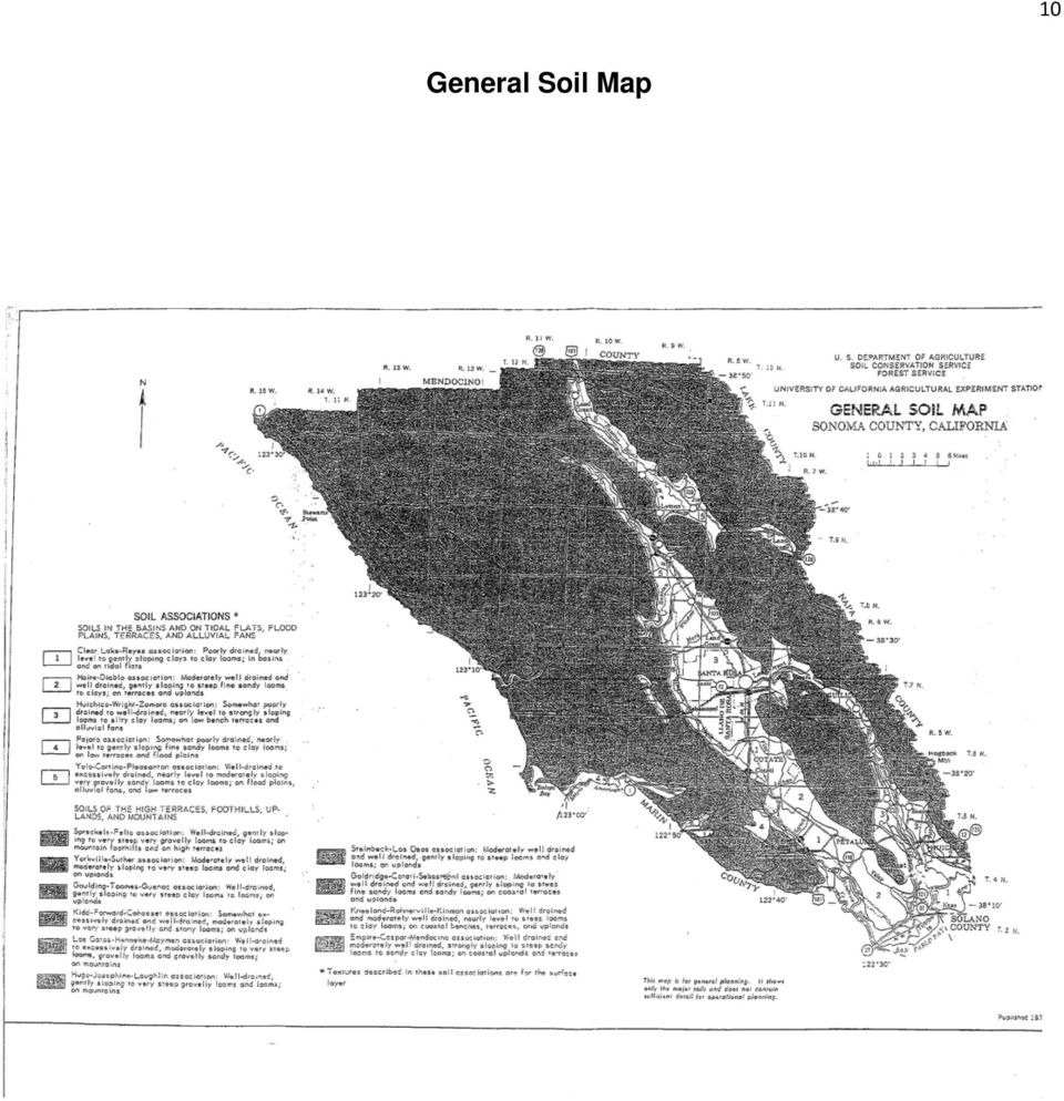
6 4 far northeast, the remote interior of the Mayacamas Range contains the Geysers geothermal steam field. Geology, Soils and Water Resources Geology The topography in Sonoma County is varied, including several mountain ranges, distinctive valleys, and coastal terraces. The geology is quite complex and is continually evolving because of its location at an active plate margin. The county is bounded on the south by the San Pablo Bay and associated wetlands. The Cotati and Petaluma Valleys create the wide basin stretching from Santa Rosa to the Bay. Rolling hills and grasslands predominate here, as well as in Marin County to the south. The rugged Mayacamas and Sonoma Mountains geographically form the eastern boundary and physically separate Sonoma County from Lake and Napa Counties. The Sonoma Valley runs north-south between the Sonoma Mountains on the west and the taller Mayacamas Mountains to the east. The Geysers geothermal field, located in the northeastern section of the county, extends into both Sonoma and Lake Counties. The Mendocino Highlands form a common geographic unit with Mendocino County to the north. The Alexander Valley runs from northwest to southeast, bounded on the east by the Mayacamas Mountains and on the west by the Coast Range. The Pacific Ocean forms the western county boundary, including an interesting assemblage of steep hills, marine terraces, beaches, and offshore sea stacks. The geology of Sonoma County is a result of the past tectonic, volcanic, erosion, and sedimentation processes of the California Coast Range geomorphic province. Ongoing tectonic forces resulting from the collision of the North American Plate with the Pacific Plate, combined with more geologically recent volcanic activity, have resulted in mountain building and down warping of parallel valleys. The margin of the two tectonic plates is defined by the San Andreas Fault system: a broad zone of active, dormant, and inactive faults dominated by the San Andreas Fault which trends along the western margin of the county. This fault system results in the northwestern structural alignment that controls the overall orientation of the county s ridges and valleys. The land has been modified by more recent volcanic activity, evidenced by Mount St. Helena that dominates the northeastern part of the county. Erosion, sedimentation, and active faulting occurring in recent times have further modified Sonoma County s landscape to its current form. Soils The Sonoma County soils are divided into two main categories as follows: Soils in the basins and tidal flats, flood plains, terraces and alluvial fans. The soils in the basins and tidal flats, flood plains, terraces and alluvial fans are level to steep and excessively drained to poorly drained. These soils consist of very gravelly sandy loams to clays. They formed in alluvium from sedimentary and volcanic material. The areas are mainly in the eastern part of the county.

7 5 Elevation of these soils ranges from 2 feet below sea level to 1,200 feet above, and annual precipitation from 20 to 50 inches. Five of the soil associations in Sonoma County are in basins and tidal flats, flood plains, terraces and alluvial fans. They make up 20 percent of the county. Refer to Map 1 for soils series distribution. 1. Clear Lake-Reyes Association: Poorly drained, nearly level to gently sloping clays to clay loams; in basins and on tidal flats. This association occupies about 6% of the county. 2. Haire-Diable Association: Moderately well drained and well drained, gently sloping to steep fine snady loams to clays; on terraces and uplands. This association occupies about 4% of the county. 3. Huichica-Wright-Zamora Association: Somewhat poorly drained to well drained, nearly level to strongly sloping loams to silty clay loams; on low bench terraces and alluvial fans. This association occupies about 6% of the county. 4. Pajarro Association: Somewhat poorly drained, nearly level to gently sloping fine sandy loams to clay loam; on low terraces and flood plains. This association occupies about 1% of the county. 5. Yolo-Cortina-Pleasanton Association: Well-drained tio excessively drained, nearly level to moderately sloping very gravelly sandy loams to clay loams; on flodd plains, alluvial fans, and low terraces. This association occupies about 3% of the county. Soils in the high terraces, foothills, uplands, and mountains. The soils in the high terraces, foothills, uplands, and mountains are nearly level to excessively steep and moderately well drained to excessively drained. These soils consist of gravelly, very gravelly, or stony loams to clay loams. They formed in material weathered from such rock as volcanic tuff, rhyolite, serpentine, sandstone, shale, and metamorphosed schist, as well as basic igneous rock. The areas are scattered throughout the county. Elevation of these soils ranges from 100 to 4,000 feet, and annual precipitation from 20 to 70 inches. Ten of the soil associations in Sonoma County are in soils in the high terraces, foothills, uplands, and mountains. They make up 80 percent of the county. 1. Spreckels-Felta Association: Well-drained, gently sloping to very steep very gravelly loams to clay loams; on mountain foothills and on high terraces. This association occupies about 4% of the county. 2. Yorkville-Suther Association: Moderately well drained, moderately sloping to very steep loams and clay loams; on uplands. This association occupies about 8% of the county. 3. Goulding-Toomes-Guenoc Association: Well-drained, gently sloping to very steep clay loams; on uplands. This association occupies about 8% of the county.

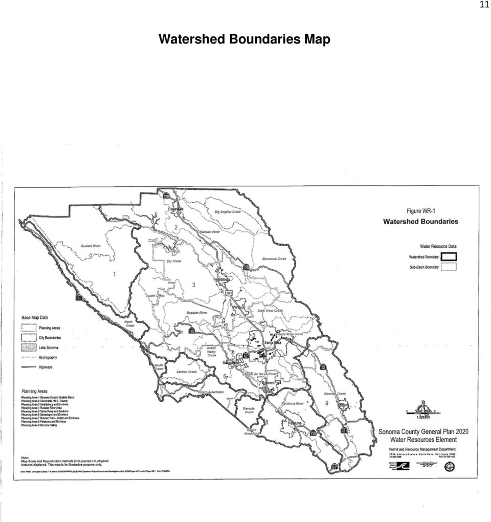
8 6 4. Kidd-Forward-Cohasset Association: Somewhat excessively drained to well-drained, moderately sloping to very steep gravelly and stony loams; on uplands. This association occupies about 2% of the county. 5. Los Gatos-Henneke-Maymen Association: Well-drained to excessively drained, moderately sloping to very steep loams, gravelly loams, and gravelly sandy loams; on mountains. This association occupies about 7% of the county. 6. Hugo-Josephine-Laughlin Association: Well drained, gently sloping to very steep gravelly loam and loams; on mountains. This association occupies about 33% of the county. 7. Steinbeck-Los Osos Association: Moderately well drained and well drained, gently sloping to steep loams and clay loams; on uplands. This association occupies about 6% of the county. 8. Goldridge-cotati-Sebastopol Association: Moderately well drained and well drained, gently sloping to steep fine snady loams and sandy loams; on coastal terraces and uplands. This association occupies about 6% of the county. 9. Kneeland-Rohnerville-Kinman Association: Well drained and moderately well drained, nearly level to steep loams to clay loams;on coastal benches, terraces, and uplands. This association occupies about 3% of the county. 10. Empire-Casper-Mendocino Association: Well drained and moderately well drained, strongly sloping to steep sandy loams and sandy clay loams; on coastal uplands and terraces. This association occupies about 3% of the county. Surface Waters Sonoma County contains four principal watersheds: Gualala-Salmon, Russian River, San Pablo Bay, and Tomales Drake Bay. The 2020 Sonoma County General plan identifies the following watersheds and watershed sub-basins. Refer to Map 2 for watershed boundaries Watershed Watershed sub-basin Size (Sqare Miles) Gualala River 269 Russian River Big Sulphur Creek 80 Maacama Creek 69 Dry Creek 175 Mark West Creek 83 Laguna de Santa Rosa 89 Green Valley and 37 Atascadero Creeks Austin Creek 70

9 7 Santa Rosa Creek 81 Other subwatersheds 237 Watershed total 921 Coastal North Coast 49 South Coast 9 Salmon Creek 37 Estero Americano 50 Stemple Creek 22 Watershed total 167 San Pablo Bay Sonoma Creek 170 Petaluma River 112 Watershed total 282 In general, watersheds in the northern areas of the County (Gualala River, Austin Creek, Dry Creek, Big Sulphur Creek, and Maacama Creek) consist of mountainous, rugged terrain with little urban development. Land use in these upper watersheds is predominantly rural, with timber production and grazing being the primary uses. Most of central Sonoma County is part of the Russian River watershed and ultimately drains west to the Pacific Ocean. This area has moderate topography and lies in the ancient alluvial floodplain of the Russian River. Much of the suburban and urban development of Sonoma County is located within these central sub-watersheds, including Healdsburg, Windsor, Santa Rosa, Sebastopol, Rohnert Park and Cotati. The watersheds for the Petaluma River and Sonoma Creek in the southern portions of the county are tidally influenced. They have their headwaters on the steep grass and oak foothills of the Sonoma Mountains and Coast Range, pass through small valleys where the Petaluma and Sonoma urban areas are located, and open up to wide marshlands that interact with the San Pablo Bay. Land use in these subbasins is varied and includes agriculture and rural and urban residential use. Many small watersheds in the Coastal Zone consist of streams that drain relatively small watersheds and flow a short distances from the first coastal ridgeline directly to the Pacific Ocean. These individual small coastal drainage basins are collectively referred to as the Frontal Pacific Ocean watershed. Streams in these watersheds flow though areas of steep terrain and marine terraces. Coastal streams typically enter the ocean at small sandy beach inlets periodically along steep rocky coastal bluffs.

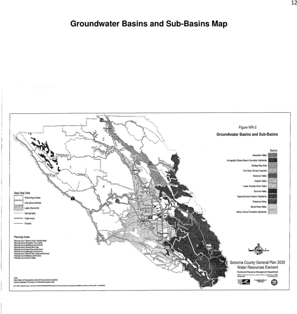
10 8 Groundwaters The size of the nine identified groundwater basins in Sonoma County range from the Santa Rosa valley (158 square miles) to the Fort Ross Terrace Deposits (3.5 square miles). The 2020 Sonoma County General plan identifies the following groundwater basins..refer to Map 3 for groundwater basin boundaries. Groundwater Basin Size (Square Miles) Santa Rosa Valley 158 Sonoma Valley 70 Petaluma Valley 70 Napa-Sonoma Volcanics 65 Alexander Valley 47 Annapolis-Ohlson Ranch Formation 13.5 Kenwood Valley 8 Knights Valley 6 Fort Ross Terrace Deposits 3.5 Groundwater is an important source of agricultural, industrial, and domestic water supply in Sonoma County. While the Russian River is the primary source of domestic water for the County s urban areas, most rural areas are served by groundwater. Groundwater resources are tapped by both municipal and private wells. However, not all groundwater in the County is of sufficient volume, has a reasonable rate of recharge, or is suitable for drinking water or other purposes. Most of these groundwater basins are centered along major creek and river valleys in the central and southern portions of the county. Recharge of groundwater typically occurs along the major streams as well as their principal tributaries. The principal water bearing formations in Sonoma County groundwater basins are typically alluvium. While other geologic units can yield adequate amounts of water in some areas, much of the county may not have dependable groundwater supplies. Poor groundwater quality can be the result of geologic conditions such as the highly mineralized water extracted from the Sonoma Volcanics or brackish water from the Petaluma Formation. Also, some groundwater naturally contains dissolved elements such as arsenic, boron, selenium, mercury and/or radon (a gas formed by the natural breakdown of uranium in the soil). Estimated OWTS Usage by Watershed In 2015, Sonoma County initiated a project using Geographic Information System (GIS) analysis to begin the process of locating, characterizing and tracking the OWTS in the County. Refer to Map 4 for those areas outside municipal sewer district boundaries. Since a comprehensive inventory of existing OWTS usage does not exist, estimates are based on a systematic GIS-based inventory to determine the development status (i.e. developed or vacant)

11 9 of all parcels in the non-sewered areas of the county, which is taken as the best estimate of the current number of OWTS in the county. Throughout the remaining incorporated areas of Sonoma County there are a number of individual lots and small pockets of development not connected to municipal sewers. These lots were not included in usage estimates, as they tend to be widely scattered and represent a very small fraction of the total OWTS in the County, The study determined that there are an estimated 43,838 properties served by OWTS. Of the estimated properties served by OWTS, an estimated 17,636 are permitted code conforming Standard OWTS or legal non-conforming OWTS; an estimated 2,052 are Non-Standard Experimental, Alternative or Commercial OWTS subject to our Operational Permit and Monitoring requirements; and an estimated 23,385OWTS are considered unpermitted (no records available). To assist with present and future management of OWTS and water quality assessments, Table 1 shows the watershed basins along with the estimates of OWTS usage (i.e. developed parcels in each watershed basin in the non-sewered areas), along with the breakdown for parcel size less than and greater than one acre. This table constitutes the best current estimate of the usage and distribution of OWTS in Sonoma County. Table 1 Watershed Total Watershed Area acres (Sq Mi) Non- Sewered Area acres (Sq Mi) Total Existing Parcels (<1 acre) Developed (<1 acre) Vacant (<1 acre) Total Existing Parcels (>1 acre) Developed (>1 acre) Vacant (>1 acre) Gualala-Salmon (316) Russian River (914) San Pablo Bay Tomales-Drake Bay (276) (69) Total (1575)

12 General Soil Map 10
13 Watershed Boundaries Map 11
14 Groundwater Basins and Sub-Basins Map 12
15 13 Summary of Water Quality Management Measures The following summarizes how key site suitability, land use and development factors have been addressed in the OWTS requirements of Sonoma County s LAMP for protection of water quality. Soil Conditions. Soil suitability is the single most critical aspect of onsite wastewater treatment and dispersal. The soil provides the medium for the absorption and treatment of wastewater discharged through sub-surface dispersal systems. This is accomplished mainly through a combination of physical filtering, biological and chemical processes, and dilution. Protection of underlying groundwater relies on provision of an adequate depth of permeable soil below the dispersal field (zone of aeration) for absorption and treatment to occur. Sonoma Countyrequires detailed site evaluation to document suitable soil characteristics and depth for each OWTS installation. The observed depth and percolation characteristics of the soil are used to select the appropriate location, sizing and design of the OWTS to achieve proper effluent dispersal and groundwater protection. Geologic Factors. Geology is important to the suitability and performance of OWTS due to its influence on topography and landforms, the type and characteristics of soils that develop at the surface, the occurrence and movement of sub-surface water, and slope stability. Geologic factors are addressed for new OWTS based on information from basic site evaluations for all installations, including information of percentage of slope and proximity to potential unstable land masses. Groundwater Conditions. Groundwater conditions are of high importance for OWTS usage in Sonoma County due to the extensive reliance on local aquifers for both public and private water supplies. Site evaluation practices include requirements for documenting groundwater conditions, which include procedures for wet weather observations. Documentation of groundwater levels, in combination with soil permeability (percolation rate), provide the basis for selection of the appropriate OWTS design and maintenance of an appropriate vertical separation between the point of effluent dispersal and the water table for protection against pathogen impacts. Areas with High Usage of Domestic Wells. Domestic wells areused widely in Sonoma County in conjunction with rural development that also utilize OWTS. Measures to assure protection of existing and new domestic water supply wells from the effects of OWTS include minimum horizontal setback distances between OWTS and any well and the availability of alternative non-standard treatment and dispersal technologies to mitigate documented or potential impacts to groundwater in area of high domestic well usage. Minimum Watercourse/Water Body Setback Requirements. The primary measure of protection of surface water quality is the establishment of safe horizontal setback distances between OWTS and various water and landscape features. Alternative Treatment and Dispersal Technologies. The County s OWTS Manual includes alternative treatment and dispersal technologies and revised sizing standards that provide flexibility options for system repairs and replacements. The use of alternative technologies, producing higher quality effluent, can compensate for reduced amount of soil absorption area where the repair system on an older non-conforming development site

16 14 encroaches within the normal setback requirement. Also, alternative dispersal methods and revised sizing criteria can reduce the amount of encroachment into the setback area by making more portions of the property (e.g. shallow soils) potentially feasible for wastewater dispersal, while also reducing the overall amount of land area needed for the dispersal system. Erosion Control Measures. The County requires that erosion control measures be implemented in connection with the installation of OWTS under certain circumstances, based on the type and size of the system and the prevailing ground slope conditions. Flood Protection Measures. The County prohibits the installation of new OWTS within the F-1 floodway. Enhanced Protection for Water Supply Watersheds. In accordance with the requirements of the OWTS Policy, the County has increased the setback standards for any OWTS located in an area tributary to and within 1200 feet and within 2500 feet of a public water supply surface water intake. The provisions for identifying and notifying public water system owners of pending OWTS applications are discussed in Section 3.5 of this LAMP. Impaired Surface Waters. Sonoma Creek is subject to a 2010 TMDL Implementation Plan, prior to the adoption of the OWTS Policy (Appendix B) The Russian River Watershed Pathogen TMDL Advanced Protection Management Program (APMP) will be addressed as a Part 3 addendum to this LAMP. The Draft Russian River TMDL Implementation Plan is found in Appendix C and will be replaced upon adoption of the final TMDL Implementation Plan. High Density OWTS, Parcel Size and Cumulative Impacts. Consideration of OWTS density, parcel size and potential cumulative impact issues (e.g. hydraulic mounding, nitrate loading) are addressed in County Code that call for the completion of cumulative impact assessments for certain types of projects or locations. Geographic Areas with Many Older Non-Conforming OWTS Installations and Setbacks. Older, non-conforming OWTS are common in areas of the county. The highest concentration of these OWTS are located near the Russian River and its tributaries, where properties were originally developed for seasonal/recreational cabins and have converted over the years to year round residences. Many of the properties are very small (<1/2 acre in size), with OWTS constructed prior to the modern codes. Some systems consist of cesspools, and repairs/replacements tend to be very challenging. Non-conformance with adopted setback requirements (e.g. from structures, water features, etc) are also common. The availability of alternative treatment and dispersal system designs provide an opportunity for more effective upgrades and repairs for lots having limited area, soil limitations or other constraints for conventional OWTS 3.0 Local Agency Requirements and Responsibilities The Sonoma County LAMP establishes the Tier 2 minimum requirements and responsibilities that provide an alternative from Tier 1 (Sections 7 and 8 of the OWTS Policy) to achieve the same policy purpose of protecting water quality and public health.
 potentially feasible for wastewater dispersal, while also reducing the overall amount of land area needed for the dispersal system.")
17 15 3.3: Annual Report Sonoma County PRMD shall submit a report to the NCRWQCB, with a copy to the SFBRWQCB, that includes the following information: Number and location of complaints, complaint investigations and outcomes Permits issued for septic tank pumper trucks Number. Location, and description of permits issued for new and replacement OWTS with Tier indicated. 3.4: Permanent Records All OWTS permit related records (Pre-Perc and Site Inspections, Wet Weather Groundwater Inspections, OWTS Plan Checks, New and Replacement Standard and Non-Standard OWTS Permits, Operational Permits for Non-Standard OWTS, Abatement and Voluntary Repair Permits, Findings Report Review, Office and Field Clearances for B-BLD Upgrade Permits, Septic Tank Replacement, Septic Tank Destruction, and Variance Requests are maintained in the County s database. 3.5: Public Water Supply Notification The PRMD shall notify the owner of a public well or water intake by telephone, , and/or site visit as soon as practicable but no later than 72 hours, upon discovery of a failing OWTS within the allowable setbacks as follows: OWTS Section 7.5.6: 150 feet from a public water well where the depth of effluent dispersal field does not exceed 10 feet. OWTS Section 7.5.7: Within 1200 feet from a public water system surface water intake if the failing system is 400 feet or less from the high water mark. OWTS Section 7.5.8: Within 2500 feet from a public water system surface intake if the failing system is less than 200 feet from the high water mark. Currently, there are 12 surface water intake public water supply systems and 410 well public water supply systems in Sonoma County. In addition, there are 61 state Small water Systems that are overseen by the County Department of health Services, Environmental Health Division. It should be noted that some of the public water supply systems that are classified as wells rely on water supplies that are groundwater under the influence of surface water. At this time, the public well and public surface water intake locations are confidential and cannot be captured in the County GIS database. The State Water Resources Control Board (Division of Drinking Water Programs) is in the process of mapping service area boundaries of all public water supply systems, but not the actual locations of public wells and surface water intakes.. Every effort will be made to notify public water systems of the location of a failing OWTS if it is determined to be within setback requirements. In addition, the setback requirements for OWTS permit applications (new, repair,

18 16 replacement) have been expanded to include a 150 foot setback from public water supply wells and 400 feet from public water supply systems that rely on surface water. 9.0: Local Agency Management Program for Minimum OWTS Standards This Tier 2 LAMP establishes minimum standards that provide an alternative from Tier 1 (Sections 7 and 8 of the OWTS Policy) to achieve the same policy purpose of protecting water quality and public health. 9.1: Considerations for LAMP Differing system design requirements are discussed in the accompanying OWTS Manual Section 11 (Criteria for Commercial OWTS), Section 12 (Criteria for Non-Standard Experimental OWTS), and Section 13 (Criteria for Non-Standard Alternative OWTS). Differing siting controls such as system density and setback requirements. For the creation of new parcels, the Sonoma County Code Section requires a minimum lot size of 11/2 acres where an OWTS and a private water supply system are necessary or 1 acre where the OWTS is necessary but water is available from an approved public water system. In either case, there shall be sufficient area on the parcel to accommodate an OWTS for a typical three (3) bedroom house plus an unencumbered 200% reserve replacement area. OWTS Manual Appendix F (Sonoma County Code References) Setback requirements for new development on existing parcels are discussed in the accompanying OWTS Manual Section 7 (Site Evaluation Methods and Investigation Requirements). Setback requirements for repair and replacement OWTS on existing nonconforming occupied (within previous 5 years) parcels are discussed in the accompanying OWTS Manual Section 5 (OWTS Repairs) and Section 6 (OWTS Requirements for Approval of Building Permits). Requirements for owners to enter monitoring and maintenance agreements. Discussion of this requirement is found in the accompanying OWTS Manual Section 14 (Non-Standard and/or Commercial OWTS Operational Permit and Monitoring). Creation of onsite management district or zone. The Sea Ranch HOA and the Odd Fellows HOA are the only recognized onsite management districts in the county at this time. It is anticipated that with the Russian River TMDL Implementation Plan, that additional districts or zones may be created and will be addressed in the Advanced Protection Management Plan as Part 3 of this LAMP : Degree of vulnerability to pollution due to hydrological conditions within your jurisdiction In addition to the water quality assessment program monitoring discussed in further detail in Section 9.3.2, PRMD may occasionally sample Non-Standard OWTS performance wells for total coliform and fecal coliform bacteria and nitates as indicators of the degree of treatment and function of Non-Standard OWTS. If evidence indicates a hyrogeologically vulnerable area, the LAMP will be updated based on the data collected during the five (5) years between LAMP
, Section 12 (Criteria for Non-Standard")
19 17 assessment reports. OWTS Manual Chapter 14 (Non Standard and/or Commercial OWTS Operational Permit and Monitoring) 9.1.2: High Quality Waters and Other Environmental Concern Mimimum parcel sizes for new parcels are dictated by Sonoma County Code Section The minimum lot size is one and one-half (1 ½) acres where an OWTS and an individual water supply system is necessary. The minimum lot size is one (1) acre where an OWTS is necessary but water is available from an approved public water supply system. Existing geographic areas with existing higher densities that predate current code requirements are considered as Tier 0 and will remain as such until or unless a failure is documented, in which case the system will be repaired per the requirements of Tier 2 or Tier 3, as applicable. The primary measure for protection of surface water quality is the establishment of safe horizontal setback buffers between OWTS components (septic tanks and dispersal field) and various water and landscape features. They address setbacks to springs, perennially and intermittent flowing streams, ephemeral drainage ways, ocean, lakes, ponds, wetlands, vernal pools, cut banks natural bluffs and sharp changes in slope. OWTS Manual Appendices F (Sonoma County Code References) and B (Table 7.2c Setback Requirements) : Shallow Soils Requiring a Dispersal System that is closer than is Standard The Sonoma County OWTS Manual requires a Qualified Consultant perform site evaluations. If shallow soils are found, a Non-Standard Alternative OWTS shall be designed and installed in accordance with the OWTS Manual technical standards. These standards require a conventional OWTS to have a minimum of 12 of soil cover. If unable to provide a minimum of 12 of soil cover over a conventional OWTS dispersal field due to shallow soil depth and still provide 36 minimum suitable soil depth below trench bottom, a Non-Standards Alternative OWTS is required. OWTS Manual Sections 9 (Criteria for Standard OWTS), 12 (Criteria for Non-Standard Experimental OWTS) and 13 (Criteria for Non-Standard Alternative OWTS) : High Domestic Well Usage Domestic wells are used widely in Sonoma County in conjunction with rural development that also utilizes OWTS. Measures to assure protection of existing and new domestic water supply wells from the effects of OWTS include minimum horizontal setback distances between OWTS and any well and alternative treatment and dispersal technologies to mitigate documented or potential impacts to groundwater in areas of high domestic well usage. Sonoma County is in the process of GPS mapping all new well location sites. If a pattern of areas with high domestic well usage develops, consideration will be given to further study those areas relative to areas identified as having a high incidence of OWTS failure (Abatement Repairs) or potential for failure (Voluntary Repairs and Building Permit Upgrade Permits) replacement OWTS with potential pathogen transport toward receptor wells.

20 : Fractured Bedrock The Sonoma County OWTS regulations and technical standards require a qualified professional (registered geologist, soil scientist, registered civil engineer or registered environmental health specialist) to perform site evaluations. If shallow soils are found due to fractured bedrock, a Non- Standard Alternative OWTS shall be designed and installed in accordance with the Sonoma County OWTS Manual regulations and technical standards. A minimum of three (3) feet of acceptable soil between the dispersal area and the fractured bedrock is required for a conventional Standard OWTS and a minimum of two (2) feet of acceptable soil between the dispersal area and the fractured bedrock is required for the design of any Non-Standard Experimental or Alternative OWTS. OWTS Manual Sections 7 (Site Evaluation and Investigation Requirements), 9 (Criteria for Standard OWTS), 12 (Criteria for Non-Standard Experimental OWTS) and 13 (Criteria for Non-Standard Alternative OWTS) : Poorly Drained Soils The Sonoma County OWTS regulations and technical standards require a qualified professional (registered geologist, soil scientist, registered civil engineer or registered environmental health specialist) to perform site evaluations. If poorly drained soils are found due to seasonal elevated groundwater, a Non-Standard Alternative OWTS shall be designed and installed in accordance with the Sonoma County OWTS Manual regulations and technical standards. A minimum of three (3) feet of acceptable soil between the dispersal area and depth to groundwater is required for a conventional Standard OWTS and a minimum of two (2) feet of acceptable soil between the dispersal area and the depth to groundwater is required for the design of any Non-Standard Experimental or Alternative OWTS. OWTS Manual Sections 7 (Site Evaluation and Investigation Requirements), 9 (Criteria for Standard OWTS), 12 (Criteria for Non-Standard Experimental OWTS) and 13 (Criteria for Non-Standard Alternative OWTS) : Vulnerable Surface Water Sonoma County requires a 100 foot setback to any perennial or intermittent water course, lake or pond and a 200 foot setback to any surface water supply watershed reservoir and a 400 foot setback if the OWTS is located less than 1200 feet to a public water system surface water intake. OWTS Manual Section 7.2 (General Site Criteria) and Appendix B (Table 7.2c Setback Requirements) : Impaired Water Bodies Sonoma Creek is subject to a previously approved TMDL Implementation Plan, established prior to the adoption of the OWTS Policy. Identified areas within the Russian River Watershed subject to the TMDL Pathogen Reduction Implementation Plan will be addressed in a separate Advanced Protection Management Program (APMP) as an addendum (Part 3) and upgrade of this LAMP from Tier 2 to Tier 3 authorization (Appendices B and C).

21 : OWTS Located in an Area of High Density OWTS Nitrate has been identified as a chronic issue several areas of Sonoma County. The west Petaluma area and the Canon Manor area of Cotati have exhibited elevated nitrate levels in groundwater. Canon Manor is subject to a mandatory sewer and water connection requirement. Although the nitrate contamination issue in the west Petaluma area can be traced primarily to historical poultry farming practices, it is recognized that the density of housing, volume of discharge and depth of OWTS dispersal fields may contribute to the levels of nitrate found in groundwater. All lots in this designated west Petaluma area are subject to wet weather percolation testing, groundwater determinations and in most instances installation of an interceptor drain. In addition, 100 foot well seals are required. OWTS Manual Section 18 (Variance Prohibition and Special Standards Areas). Also, refer to Section Regional Salt and Nutrient Management Plan : Limits to Parcel Size Minimum new parcel sizes are dictated by Sonoma County Code Section Minimum lot size shall be one and one-half (1 ½) acres where individual OWTS and water supply systems are necessary, unless the size and shape of the site and surrounding parcels allow for a lesser lot size. Minimum lot size shall be one (1) acre where individual OWTS are necessary but water is available from an approved public water system. There shall be sufficient area on the parcel to accommodate a private OWTS for a typical three (3) bedroom house plus unencumbered area to expand or replace the system by two hundred percent (200%). These parcel size restrictions do not exceed the allowable densities per subdivision of Tier 1, section 7.8 of the OWTS Policy. (OWTS Manual Appendix F (Sonoma County Code References) : Areas with Multiple, Existing OWTS Predating Any Adopted Standards Older, non-conforming OWTS are common in several areas of the County. The highest concentration of these OWTS is in those communities in the lower Russian River Watershed. These communities include Jenner, Cazadero, Monte Rio, Camp Meeker, Guerneville, Rio Nido, Summer Home Park, Hacienda, Mirabel, and Fitch Mountain near Healdsburg. These communities are identified as High Priority Areas in the Russian River Watershed Pathogens TMDL. Many of these properties were originally developed for seasonal/recreational cabins and have converted over the years to year-round residences. Many of the properties are very small (<1/2 acre in size), with OWTS constructed prior to the modern codes. Some systems consist of cesspools, and repairs/replacement systems tend to be very challenging. Non-conformance with adopted setback requirements (e.g. from structures, water features, cut banks and sharp changes in slope, etc.) are also common. OWTS Manual Section 5 (OWTS Repairs) and 6 (OWTS Requirements for Approval of Building Permits) : Areas with Multiple, Existing OWTS Within Prescriptive Tier 1 Setbacks Aside from those areas identified in the Sonoma Creek and Russian River Watershed Pathogens TMDL, there are no other significant areas in Sonoma County with known multiple, higher density
22 20 developments with existing OWTS that are within the prescriptive setbacks set forth in Section 7.5 of the OWTS Policy. Those that may exist are limited and dispersed throughout the County. The County has identified several areas with a concentration of OWTS that are subject to Variance Prohibitions due to other factors, such as low permeable or extremely permeable soils, known elevated groundwater tables, poor surface and/or subsurface drainage and/or nitrate contamination. OWTS Manual Section 18 (Variance Prohibition and Special Standards Areas). 9.2: Scope of Coverage, Permitting, Site Evaluation, Design, and Construction The Sonoma County LAMP covers the following types of OWTS: residential and commercial domestic wastewater systems producing flows of 10,000 gallons per day or less; high strength domestic wastewater from commercial food service buildings that do not exceed 900 mg/l BOD; and the subsurface dispersal of winery process wastewater, in collaboration with the RWQCB requirements. The OWTS Manual provides regulations/guidelines for the local site evaluation conducted by a qualified professional, siting, design, construction monitoring and maintenance requirements. OWTS Manual Sections 4 (Criteria for all OWTS), 7 (Site Evaluation Methods and Investigation Requirements), 9 (Criteria for Standard OWTS), 11 (Criteria for Commercial OWTS), 12 (Criteria for Non-Standard Experimental OWTS), 13 (Criteria for Non- Standard Alternative OWTS), 14 (Non-Standard and/or Commercial OWTS Operational Permit and Monitoring) : Installation/Inspection Permits Sonoma County requires an application and issuance of a valid permit to install, repair, replace, modify, destroy, or abandon any part of an OWTS. All new installations, including repairs, replacements and abandonments require a plan review, issued permit and construction inspection for final permit approval. Additionally, all new Commercial and Non-Standard Experimental and/or Alternative OWTS require annual operating permits and routine inspections by either the County and/or a service provider. OWTS Manual Sections 4.6 (OWTS Permits), 4.11 (Construction Inspections), and 14 (Non-Standard and/or Commercial OWTS Operational Permit and Monitoring) : Special Provisions for OWTS near Impaired Water Bodies In 2006, the San Francisco RWQCB and the State Water Resources Control Board adopted an amendment to the Water Quality Control Plan (Basin Plan for the San Francisco Bay region to establish a Sonoma Creek Watershed Pathogen Total Maximum Daily Load (TMDL) and Implementation Plan. The adopted TMDL designated Sonoma County, specifically the Permit and Resource Management Department (PRMD) as the responsible party for implementing actions related to OWTS and required a plan and implementation schedule be submitted to the RWQCB by January This plan was submitted on November 5, 2010 and is found in Appendix B. In 2015, the North Coast RWQCB and the State Water Resources Control Board proposed the adoption of an amendment to the Water Quality Control Plan (Basin Plan for the North Coast region to establish a Russian River Watershed Pathogen Total Maximum Daily Load (TMDL) and Implementation Plan. The County will prepare and submit an addendum to this LAMP (Part 3) to address OWTS in the identified impacted areas
23 : Variance Process The LAMP recognizes that not all new replacement and repair OWTS will be able to meet minimum required setbacks, soil depth, groundwater separation, and/or additional minimum requirements and has therefore provided for a process for the evaluation and approval of variance requests. The variance process will not authorize any of the prohibited items in Section 9.4 of the OWTS Policy. OWTS Manual Section 17 (Variance Requirements) : Educational, Training, Certification, Licensing Requirements The OWTS Manual provides minimum educational, training, certification, and/or licensing requirements that are required for OWTS Site Evaluators, Designers, Installers, Service Providers, Pumpers, and any other person relating to OWTS activities. OWTS Manual Sections 4.3 (OWTS Designer Qualifications), 6.2 (B-BLD OWTS Clearance Procedure), 7.1 (Site Evaluations), 11 (Criteria for Commercial OWTS), 12 (Criteria for Non-Standard Experimental OWTS),13 (Criteria for Non-Standard Alternative OWTS), 14 (Non-Standard and/or Commercial OWTS Operational Permit and Monitoring), Appendix F (Sonoma County Code References, Section Cleaning Septic Tanks, etc. Permit Required) : Education and Outreach Program The primary method of education and outreach is by direct interaction between PRMD staff and the public. PRMD staff routinely receives and responds to phone calls and office visits by private property owners, consultants and contractors with questions about the regulations and/or the permit process. Documents, links, reports, frequently asked questions, etc are available on the PRMD website. In addition, the Land Use Advisory Panel (LUAP) provides a forum for industry representatives (consultants, contractors, real estate community) to meet and discuss existing and proposed regulations and policy and procedure issues with PRMD staff. The LAMP provides for an education and outreach program including informational materials to inform OWTS owners of standard and non-standard systems about how to locate, operate and maintain their OWTS. In addition, the County hosts a yearly one day educational outreach program to owners of non-standard OWTS. See LAMP Appendices D (List of Recommended practices for Septic System Installations) and E (Guidelines for Maintaining a Non-Standard Septic System) : Septage Volumes and Disposal Locations Septage receiving facilities for septage generated from within Sonoma County are available at East Bay MUD in Oakland and to a lesser extent, the Laguna Subregional Wastewater Treatment Facility in Santa Rosa. The County of Sonoma Department of Health Services is the responsible agency for licensing of septic tank pumpers and haulers : On-Site Maintenance Districts or Zones In 1987, the Sonoma County Board of Supervisors formed Zone 2 under the jurisdiction of County Service Area #41. In accord with a 1989 agreement with the county, the Sea Ranch Association operates the Zone subject to the control and supervision of Sonoma County PRMD. The PRMD is
Georgia Department of Public Health. Georgia Onsite Sewage Management Systems. Background and Use of Onsite Wastewater Treatment Systems in Georgia
 Georgia Department of Public Health Georgia Onsite Sewage Management Systems Background and Use of Onsite Wastewater Treatment Systems in Georgia Background On-site sewage management systems are designed
WATER RESOURCES ELEMENT
 Sonoma County General Plan 2020 WATER RESOURCES ELEMENT Sonoma County Permit and Resource Management Department 2550 Ventura Avenue Santa Rosa, CA 95403 Adopted by Resolution No. 08-0808 of the Sonoma
4.2 Buena Vista Creek Watershed
 Buena Vista Creek Watershed 4.2 Buena Vista Creek Watershed Watershed Overview The Buena Vista Creek Watershed is the fourth-largest system within the Carlsbad Hydrologic Unit. The watershed extends approximately
Local Agency Management Plan For Onsite Wastewater Treatment Systems County of Santa Clara Department of Environmental Health
 Local Agency Management Plan For Onsite Wastewater Treatment Systems County of Santa Clara Department of Environmental Health 1555 Berger Drive, Suite 300 San Jose, CA 95112 408-918-3400 www.ehinfo.org
Package Treatment Plant Policy and Procedure
 Package Treatment Plant Policy and Procedure PURPOSE There has been increased interest in the use of package treatment plants for new development proposals in the County. Current review procedures are
NATURAL RESOURCES & NATURAL FEATURES
 A3 NATURAL RESOURCES & NATURAL FEATURES INTRODUCTION This chapter will discuss the topography, geology, soils, and other natural features found in Casco Township. The identification of the natural features
INFORMATION SHEET ORDER NO. R5-2011-XXXX TRIANGLE ROCK PRODUCTS, INC. FLORIN ROAD AGGREGATE PLANT SACRAMENTO COUNTY
 ORDER NO. R5-2011-XXXX INFORMATION SHEET Background Triangle Rock, Inc. (Discharger) submitted a Report of Waste Discharge (RWD) on 23 August 2010. The Discharger is expanding the mining operations at
STATE OF VERMONT AGENCY OF NATURAL RESOURCES DEPARTMENT OF ENVIRONMENTAL CONSERVATION WASTE MANAGEMENT DIVISION SOLID WASTE MANAGEMENT PROGRAM
 STATE OF VERMONT AGENCY OF NATURAL RESOURCES DEPARTMENT OF ENVIRONMENTAL CONSERVATION WASTE MANAGEMENT DIVISION SOLID WASTE MANAGEMENT PROGRAM Solid Waste Management Program Waste Management Division 103
Town of Ware Board of Health. Regulations for Percolation Tests, Soil Evaluations, Design, and Technical Review of Subsurface Sewage Disposal Systems
 Town of Ware Board of Health Regulations for Percolation Tests, Soil Evaluations, Design, and Technical Review of Subsurface Sewage Disposal Systems Section 1: Authority- The Ware Board of Health adopts
Earth Science. River Systems and Landforms GEOGRAPHY 1710. The Hydrologic Cycle. Introduction. Running Water. Chapter 14.
 Earth Science GEOGRAPHY 1710 River Systems and Landforms DAVID R. SALLEE Robert W. Christopherson Charlie Thomsen Chapter 14 Introduction Rivers and streams are dynamic systems that continually adjust
Glen Hills Area: Septic System and Public Sewer Q & A Information Sheet Page 1
 Glen Hills Area: Septic System and Public Sewer Q & A Information Sheet Page 1 The Montgomery County Dept. of Environmental Protection, in cooperation with the Dept. of Permitting Services and the Washington
Guidelines for Remodeling and Additions with Respect to On-site Wastewater Treatment Systems
 PURPOSE Guidelines for Remodeling and Additions with Respect to On-site Wastewater Treatment Systems The Sonoma County Permit and Resource Management Department (PRMD) Well and Septic Division strives
ON-SITE WASTEWATER TREATMENT SYSTEMS ACT
 ON-SITE WASTEWATER TREATMENT SYSTEMS ACT Revised and reproduced by the Colorado Department of Public Health and Environment June, 2012 (PLEASE NOTE: This is an unofficial copy of this statute. The official
SPDES PRIVATE, COMMERCIAL, INSTITUTIONAL GENERAL PERMIT FOR SANITARY WASTEWATER DISCHARGES TO GROUNDWATER FACT SHEET
 SPDES PRIVATE, COMMERCIAL, INSTITUTIONAL GENERAL PERMIT FOR SANITARY WASTEWATER DISCHARGES TO GROUNDWATER FACT SHEET for Permit No. GP-0-15-001 Issued Pursuant to Article 17, Titles 7, 8 and Article 70
SECTION 6 EXISTING WASTEWATER MANAGEMENT SYSTEMS
 SECTION 6 EXISTING WASTEWATER MANAGEMENT SYSTEMS This section will describe the Town s existing wastewater management systems. This includes on-site disposal systems and private collection systems. The
Appendix A: Affordable Housing Site Inventory
 Appendix A: Affordable Housing Site Inventory Following is a brief summary of the various sites considered for the Affordable Housing Project. Each site is provided with a photo when available and a concise
NAPA COUNTY WATERSHED SYMPOSIUM
 Planning, Building, and Environmental Services NAPA VALLEY GROWTH NAPA COUNTY WATERSHED SYMPOSIUM Plunging Forward May 15, 2015 1 YOU CAN T CROSS THE SEA MERELY BY STANDING AND STARING AT THE WATER. Rabindranath
www.sbcounty.gov Local Agency Management Program
 www.sbcounty.gov Local Agency Management Program For Onsite Wastewater Treatment Systems TABLE OF CONTENTS This document is organized into eight (8) main Chapters, which contain several sections, in order
FINAL PLAN OF REMEDIAL ACTION
 FINAL PLAN OF REMEDIAL ACTION 1000 FRENCH STREET SITE Wilmington, Delaware DE 1115 June 1999 Department of Natural Resources and Environmental Control Division of Air and Waste Management Site Investigation
3.0 PROJECT DESCRIPTION
 This chapter describes the proposed project, the Sonoma County General Plan (Draft GP 2020) that is analyzed in this EIR. It also describes the location, history, and objectives of the proposed project,
4.6 GEOLOGIC AND SEISMIC HAZARDS
 4.6 GEOLOGIC AND SEISMIC HAZARDS This Section describes the current conditions relating to the geologic and seismic characteristics of the City of Cypress. This Section concludes with an analysis of geologic
COMPREHENSIVE PLAN SECTION B, ELEMENT 4 WATER RESOURCES. April 20, 2010 EXHIBIT 1
 COMPREHENSIVE PLAN SECTION B, ELEMENT 4 WATER RESOURCES April 20, 2010 EXHIBIT 1 ELEMENT 4 WATER RESOURCES TABLE OF CONTENTS 4.1 INTRODUCTION 4.2 GOALS AND POLICIES 4.2.A General Goals and Policies 1 4.2.B
Water Conservation and the State s New Green Building Code for Residential Construction
 Water Conservation and the State s New Green Building Code for Residential Construction Silver Sponsors Media Sponsors Certified Sponsors Solano County Water Agency Zone 7 Water Agency Founding Partners
3. The submittal shall include a proposed scope of work to confirm the provided project description;
 QIN Shoreline Master Program Project Summary The Shoreline Master Program (SMP) development process for the Quinault Indian Nation (QIN) includes the completion of inventory and analysis report with corresponding
CLACKAMAS COUNTY ZONING AND DEVELOPMENT ORDINANCE
 1008 STORM DRAINAGE (3/24/05) 1008.01 PURPOSE To minimize the amount of stormwater runoff resulting from development utilizing nonstructural controls where possible, maintain and improve water quality,
AGENCY INFORMATION. kim.sone@fire.ca.gov Local phone Number (707) 576-2344 After hours/on-call (707) 889-4217, Kim Sone cell phone
 576-2344 After hours/on-call (707) 889-4217, Kim Sone cell phone") CAL FIRE kim.sone@fire.ca.gov Local phone Number (707) 576-2344 (707) 889-4217, Kim Sone cell phone There must be an act of cutting or removing of commercial timber species. If the area is determined to
CAL FIRE kim.sone@fire.ca.gov Local phone Number (707) 576-2344 (707) 889-4217, Kim Sone cell phone There must be an act of cutting or removing of commercial timber species. If the area is determined to
Indoor Water Conservation and I&I Reduction (EIR Alternatives 1 and 2)
") SECTION 2 Description of Master Plan Alternatives The six alternatives that constitute the building blocks of the IRWP Master Plan are as follows: Indoor Water Conservation (EIR Alternative 1) I&I Reduction
SECTION 2 Description of Master Plan Alternatives The six alternatives that constitute the building blocks of the IRWP Master Plan are as follows: Indoor Water Conservation (EIR Alternative 1) I&I Reduction
4. Priority Areas of Conservation
 4. Priority Areas of Conservation A. SIGNIFICANT RESOURCE AREAS This Open Space and Farmland Plan identifies the key issues facing open space and agricultural resources in the Town, highlights the location
Mission Canyon Residential Design Guidelines Workshop. Table Focus: Environmental Issues and Concerns
 Mission Canyon Residential Design Guidelines Workshop Table Focus: Environmental Issues and Concerns Grading How is Grading Regulated in Santa Barbara County? The technical aspects of grading are regulated
AGENDA ITEM SUMMARY. AGENDA ITEM TITLE: Discussion on Onsite Wastewater Treatment System (OWTS) Regulation Options
 Regulation Options") AGENDA ITEM SUMMARY WORK SESSION DATE: April 15, 2014 AGENDA ITEM TITLE: Discussion on Onsite Wastewater System (OWTS) Regulation Options STAFF RESPONSIBLE: Kurt Dahl, Environmental Health and Natural
AGENDA ITEM SUMMARY WORK SESSION DATE: April 15, 2014 AGENDA ITEM TITLE: Discussion on Onsite Wastewater System (OWTS) Regulation Options STAFF RESPONSIBLE: Kurt Dahl, Environmental Health and Natural
BASIN MANAGEMENT OBJECTIVES CHEROKEE SUBINVENTORY UNIT
 BASIN MANAGEMENT OBJECTIVES CHEROKEE SUBINVENTORY UNIT Butte County Water Advisory Committee Member John Scott Contact Information Phone Number: (530) 533-8394 Email Address: john_lewis_scott@msn.com Description
A MODEL PROGRAM FOR ONSITE SYSTEM MANAGEMENT IN THE CHESAPEAKE BAY WATERSHED
 A MODEL PROGRAM FOR ONSITE SYSTEM MANAGEMENT IN THE CHESAPEAKE BAY WATERSHED Table of Contents EXECUTIVE SUMMARY... 1 1.0 OVERVIEW OF THE MODEL PROGRAM... 5 1.1. Introduction... 5 1.2. Onsite System Nutrient
Ground Water in the Piedmont and Blue Ridge Provinces of North Carolina
 Ground Water in the Piedmont and Blue Ridge Provinces of North Carolina Prepared by: R.L. Huffman Extension Agricultural Engineering Specialist Published by: North Carolina Cooperative Extension Service
1.7.0 Floodplain Modification Criteria
 1.7.0 Floodplain Modification Criteria 1.7.1 Introduction These guidelines set out standards for evaluating and processing proposed modifications of the 100- year floodplain with the following objectives:
BEFORE THE HEARING EXAMINER FOR THURSTON COUNTY
 BEFORE THE HEARING EXAMINER FOR THURSTON COUNTY In the Matter of the Application of ) NO. SSDP 000748 ) Kevin Robinson ) FINDINGS, CONCLUSIONS ) AND DECISION For a Shoreline Substantial Development ) Permit
Rocky EEP Preliminary Findings Report Summary February 2005
 This is a DRAFT summary of the NC Ecosystem Enhancement Upper Rocky River Local Watershed Plan Preliminary Findings Report. The original, 157 page document can be found here: www.ncsu.edu/weco/rocky. The
DOÑA ANA COUNTY DESIGN STORM CRITERIA GUIDELINES FOR COMMERCIAL AND RESIDENTIAL SITES. Run-off Analysis Methods
 DOÑA ANA COUNTY DESIGN STORM CRITERIA GUIDELINES FOR COMMERCIAL AND RESIDENTIAL SITES Run-off Analysis Methods This document sets forth the minimum design, technical criteria and specifications for the
Local Agency Management Program (LAMP) for Onsite Wastewater Treatment Systems
 for Onsite Wastewater Treatment Systems") County Of San Diego Department of Environmental Health Land and Water Quality Division Local Agency Management Program (LAMP) for Onsite Wastewater Treatment Systems February 24, 2015 Final February 24,
County Of San Diego Department of Environmental Health Land and Water Quality Division Local Agency Management Program (LAMP) for Onsite Wastewater Treatment Systems February 24, 2015 Final February 24,
Onsite Wastewater Treatment Systems
 Santa Barbara County Public Health Department Environmental Health Services Onsite Wastewater Treatment Systems Local Agency Management Program Lawrence Fay, Director Revision 1: 07/21/15 2014 Revision
STEAMBOAT LAKE WATER AND SANITATION DISTRICT PETITION FOR AMENDMENT TO SERVICE PLAN TABLE OF CONTENTS. SECTION DESCRIPTION Page
 STEAMBOAT LAKE WATER AND SANITATION DISTRICT PETITION FOR AMENDMENT TO SERVICE PLAN TABLE OF CONTENTS SECTION DESCRIPTION Page 1 Executive Summary / Brief History 2 2 Services Provided / Administration
FREQUENTLY ASKED QUESTIONS. New Subsurface Sewage Treatment System (SSTS) Ordinance
 Ordinance") FREQUENTLY ASKED QUESTIONS New Subsurface Sewage Treatment System (SSTS) Ordinance General SSTS and Ordinance Questions: 1. How do SSTS treat wastewater? The best website to review SSTS system components
FREQUENTLY ASKED QUESTIONS New Subsurface Sewage Treatment System (SSTS) Ordinance General SSTS and Ordinance Questions: 1. How do SSTS treat wastewater? The best website to review SSTS system components
RECOMMENDED PROGRAM FOR WELL AND SEPTIC SYSTEM REAL ESTATE TRANSACTION INSPECTIONS
 Contra Costa Environmental Health 2120 Diamond Blvd., Suite 200 Concord, CA 94520 Phone: (925) 692-2500 Fax: (925) 692-2504 www.cchealth.org/eh/ RECOMMENDED PROGRAM FOR WELL AND SEPTIC SYSTEM REAL ESTATE
THE APPRAISAL OF REAL ESTATE 3 RD CANADIAN EDITION BUSI 330
 THE APPRAISAL OF REAL ESTATE 3 RD CANADIAN EDITION BUSI 330 REVIEW NOTES by CHUCK DUNN CHAPTER 10 Copyright 2010 by the Real Estate Division and Chuck Dunn. All rights reserved ARE 3 rd EDITION REVIEW
DOCKET NO. D-2004-008-2 DELAWARE RIVER BASIN COMMISSION. Southeastern Pennsylvania Ground Water Protected Area
 This DRAFT docket has been prepared for the purposes of the scheduled public hearing and may be substantially modified as a result of the public hearing process prior to Commission action. 8/26/2013 4:17
TEXAS: SAN ANTONIO San Antonio Protects Edwards Aquifer
 TEXAS: SAN ANTONIO San Antonio Protects Edwards Aquifer Background San Antonio, the seventh largest city in the United States, covers approximately 515 square miles of Bexar County in south central Texas.
BLACK/HARMONY/FAREWELL CREEK WATERSHED EXISTING CONDITIONS REPORT CHAPTER 12 - STORMWATER MANAGEMENT
 Harmony Creek subwatershed Harmony Creek subwatershed BLACK/HARMONY/FAREWELL CREEK WATERSHED EXISTING CONDITIONS REPORT CHAPTER 12 - STORMWATER MANAGEMENT April 2011 TABLE OF CONTENTS 1.0 INTRODUCTION...
Cost of Service Studies For the San Antonio, California Water District
 REQUEST FOR PROPOSALS TO PROVIDE: CONSULTING SERVICES TO THE SAN LORENZO VALLEY WATER DISTRICT PROJECT TITLE: ENTERPRISE WIDE COST OF SERVICE FINANCIAL STUDY RESPONSE DUE BEFORE 3:00 P.M. ON JANUARY 15,
Retention/Irrigation. Design Considerations. Soil for Infiltration Area Required Slope Environmental Side-effects
 Description Retention/irrigation refers to the capture of stormwater runoff in a holding pond and subsequent use of the captured volume for irrigation of landscape of natural pervious areas. This technology
Indiana State Department of Health Construction Guidelines for Gravity and Flood-Dose Trench Onsite Systems
 Indiana State Department of Health Construction Guidelines for Gravity and Flood-Dose Trench Onsite Systems The septic tank-absorption field sewage treatment system is composed of two major elements; the
On Site Sewage System Maintenance Inspections. March 2011. Building and Development Branch Ministry of Municipal Affairs and Housing
 On Site Sewage System Maintenance Inspections March 2011 Building and Development Branch Ministry of Municipal Affairs and Housing Introduction The Building Code Act, 1992 and Building Code (Ontario Regulation
GLOSSARY OF TERMS CHAPTER 11 WORD DEFINITION SOURCE. Leopold
 CHAPTER 11 GLOSSARY OF TERMS Active Channel The channel that contains the discharge Leopold where channel maintenance is most effective, sediment are actively transported and deposited, and that are capable
DRAFT Town Overview Why the Wastewater Management Program Was Created Block Island
 DRAFT Town Overview Why the Wastewater Management Program Was Created Island community of 10 square miles, 10 miles offshore, 42% in conservation Population: Year-round 1,000; summer overnight 10,000 plus
5.14 Floodplains and Drainage/Hydrology
 I-70 East Final EIS 5.14 Floodplains and Drainage/Hydrology 5.14 Floodplains and Drainage/Hydrology This section discusses floodplain and drainage/hydrology resources and explains why they are important
16 12 INDIVIDUAL SEWAGE DISPOSAL CODE OF HOPEWELL TOWNSHIP.
 16 12 INDIVIDUAL SEWAGE DISPOSAL CODE OF HOPEWELL TOWNSHIP. a. Purpose. Due to the environmental characteristics of Hopewell Township, the board of health developed this ordinance in 1978 to address the
Addendum. Use Attainability Analysis for Site Specific Selenium Criteria: Alkali Creek. February 23, 2009
 Addendum Use Attainability Analysis for Site Specific Selenium Criteria: Alkali Creek February 23, 2009 Prepared by MWH Americas, Inc. Prepared for EnCana Oil and Gas (USA) Inc. Page 2 Responses to Comments
River Basin Management in Croatia
 River Basin Management in Croatia 2. INTERNATIONAL RIVER BASIN MANAGEMENT HIGH LEVEL SYMPOSIUM Cappadocia/NEVŞEHİR, Turkey 16-18 April 2013 2 Water sector responsibilities are shared among: Croatian Parliament
DESCRIPTION OF STORMWATER STRUCTURAL CONTROLS IN MS4 PERMITS
 DESCRIPTION OF STORMWATER STRUCTURAL CONTROLS IN MS4 PERMITS Phase I MS4 permits require continuous updating of the stormwater system inventory owned and operated by the MS4. They also include inspection
CITY UTILITIES DESIGN STANDARDS MANUAL
 CITY UTILITIES DESIGN STANDARDS MANUAL Book 2 (SW) SW9 June 2015 SW9.01 Purpose This Chapter provides information for the design of open channels for the conveyance of stormwater in the City of Fort Wayne.
Adopted 9/23/98 CHATTAHOOCHEE CORRIDOR PLAN. The goals of the Chattahoochee Corridor Plan (hereinafter also referred to as the Plan ) are:
 are:") CHATTAHOOCHEE CORRIDOR PLAN Adopted 9/23/98 PART 1: GOALS. POLICY. COVERAGE. A. Goals The goals of the Chattahoochee Corridor Plan (hereinafter also referred to as the Plan ) are: 1. Preservation and protection
CHATTAHOOCHEE CORRIDOR PLAN Adopted 9/23/98 PART 1: GOALS. POLICY. COVERAGE. A. Goals The goals of the Chattahoochee Corridor Plan (hereinafter also referred to as the Plan ) are: 1. Preservation and protection
CHAPTER I: INTRODUCTION. Background
 CHAPTER I: INTRODUCTION Background California State Law requires each county to adopt a General Plan for the physical development of the county and any land outside its boundaries which bears relation
MASSACHUSETTS COASTAL NONPOINT PROGRAM NOAA/EPA DECISIONS ON CONDITIONS OF APPROVAL
 MASSACHUSETTS COASTAL NONPOINT PROGRAM NOAA/EPA DECISIONS ON CONDITIONS OF APPROVAL FOREWORD This document contains the basis for NOAA and EPA s decision to fully approve Massachusetts Coastal Nonpoint
CALIFORNIA AMERICAN WATER LOS ANGELES DISTRICT 2009 GENERAL RATE CASE CHAPTER: 1 INTRODUCTION AND SUMMARY OF APPLICATION
 DISCUSSION OF INFORMATION PRESENTED IN THIS CHAPTER This chapter contains information regarding the operation of the Los Angeles District of California American Water as well as tables that summarize the
Rural Residential Buildable Lands Inventory
 The Dalles Periodic Review, May 2013 Rural Residential Lands Inventory Contents Introduction and Summary... 1 Concerns related to the 2007 Analysis... 2 Rural Residential Capacity Summary... 2 Methodology...
Lance DeClue, REHS Environmental Health Specialist II County of San Diego Department of Environmental Health
 Lance DeClue, REHS Environmental Health Specialist II County of San Diego Department of Environmental Health Basic OWTS system design and function OWTS maintenance OWTS failures & repairs OWTS-STS (Supplemental
Climate, Vegetation, and Landforms
 Climate, Vegetation, and Landforms Definitions Climate is the average weather of a place over many years Geographers discuss five broad types of climates Moderate, dry, tropical, continental, polar Vegetation:
5. Environmental Analysis
 5.11 The potential for adverse impacts on utilities and service systems was evaluated based on information concerning current service levels and the ability of the service providers to accommodate the
CHAPTER 372-68 WAC WATER POLLUTION CONTROL AND ABATEMENT PLANS FOR SEWAGE DRAINAGE BASINS
 CHAPTER 372-68 WAC WATER POLLUTION CONTROL AND ABATEMENT PLANS FOR SEWAGE DRAINAGE BASINS Last Update: 6/8/88 WAC 372-68-010 Authority. 372-68-020 Purpose. 372-68-030 Definitions. 372-68-040 Planning guide.
FLOOD PROTECTION BENEFITS
 IV. (340 points) Flood Protection Benefits A. Existing and potential urban development in the floodplain (50) 1. Describe the existing and potential urban development at the site and the nature of the
Control filling, grading, dredging, and other development which may increase erosion or flood damage; and
 ARTICLE 16. FLOOD DAMAGE PREVENTION Section 16-1: Findings of Fact The flood hazard areas of the Town of Lillington are subject to periodic inundation which results in loss of life and property, health
Vineyard Site Assessment Guide
 Vineyard Site Assessment Guide A primer for effective interaction with resource and regulatory agencies in Sonoma County University of California Cooperative Extension In accordance with applicable State
3.1.8 Utilities and Service Systems
 3.1.8 Utilities and Service Systems This section discusses potential impacts to utilities and service systems, including water, wastewater, and solid waste hauling and disposal, resulting from the implementation
SPECIAL USE PERMIT 22-01. JCSA Groundwater Treatment Facility Staff Report for the November 5, 2001, Planning Commission Public Hearing
 SPECIAL USE PERMIT 22-01. JCSA Groundwater Treatment Facility Staff Report for the November 5, 2001, Planning Commission Public Hearing This report is prepared by the James City County Planning Division
Igneous rocks formed when hot molten material (magma) cools and hardens (crystallizes).
 cools and hardens (crystallizes).") Objectives You will learn about how the land of North Dakota was formed. Introduction North Dakota is a wonderful place to live. Have you ever though about how it was formed? To answer that question, you
Objectives You will learn about how the land of North Dakota was formed. Introduction North Dakota is a wonderful place to live. Have you ever though about how it was formed? To answer that question, you
Clean Water Services. Ecosystems Services Case Study: Tualatin River, Washington
 Viewed broadly, the concept of ecosystem services describes the many resources and services provided by nature. Typically, traditional planning and development practices do not adequately represent the
SEPTIC SYSTEMS. 1. Building sewer connects the building plumbing to the septic tank.
 SEPTIC SYSTEMS Who Has A Septic System? Approximately 30 percent of Connecticut s population is served by on-site subsurface sewage disposal systems (a.k.a. septic systems). This means a large percentage
9.1. Adequacy of Available Data and Monitoring Efforts
 9. DATA MANAGEMENT Data management is a crucial aspect of successful implementation of the ARB IRWMP and its component projects. This section discusses the adequacy of available data and monitoring efforts,
Definition of Tower from the Bradley County Zoning Resolution
 Definition of Tower from the Bradley County Zoning Resolution 43. TOWER. Any outdoor structure designed and constructed to support one (1) or more transmitting or receiving devices for telephone, radio
CHAPTER 2 HYDRAULICS OF SEWERS
 CHAPTER 2 HYDRAULICS OF SEWERS SANITARY SEWERS The hydraulic design procedure for sewers requires: 1. Determination of Sewer System Type 2. Determination of Design Flow 3. Selection of Pipe Size 4. Determination
Building Permit Application Packet. BUILDING CODES Adopted by La Plata County For Enforcement In The Unincorporated Areas Of La Plata County
 Building Permit Application Packet The purpose of Building Codes is to establish the minimum requirements to safe guard the public health, safety and general welfare through structural strength, means
California s Groundwater
 California s Groundwater Update 2013 A Compilation of Enhanced Content for California Water Plan Update 2013 April 2015 State of California Natural Resources Agency Department of Water Resources FINDINGS,
Vulnerability Assessment
 Vulnerability Assessment VULNERABILITY As used in this report, vulnerability refers to the sensitivity of groundwater to contamination, and is determined by intrinsic characteristics of the aquifer. It
Useful Septic System Statistics
 GENERAL Useful Septic System Statistics - About 25% of the nation s households are served by onsite/septic systems (see Census data) - Approximately 33% of new construction is served by onsite systems
SOUTHERN CALIFORNIA Regional Hydrology IMPACTS ON REGULATORY APPROACHES FOR THE FUTURE. Monitoring & Modeling
 SOUTHERN CALIFORNIA Regional Hydrology IMPACTS ON REGULATORY APPROACHES FOR THE FUTURE Monitoring & Modeling Summary This region provides a unique combination of policy issues, water quality problems,
Travel Centers of America 1003300
 Travel Centers of America 1003300 Source Water Assessment Report A State Assessment of Your Drinking Water Source s Vulnerability As a requirement of the 1996 Amendments to the Federal Safe Drinking Water
LOS ANGELES COUNTY S FLOODING HISTORY:
 LOS ANGELES COUNTY S FLOODING HISTORY: Since 1975, Los Angeles County has experienced twelve federally, declared flood disasters, with three of those disasters coming under El Niño conditions (1983, 1998,
Increasing water availability through juniper control.
 Tim Deboodt, OSU Crook County Extension Agent 498 SE Lynn Blvd. Prineville, OR 97754 541-447-6228 Tim.deboodt@oregonstate.edu Increasing water availability through juniper control. Throughout the region
A HOMEOWNERS GUIDE ON-SITE SEWAGE MANAGEMENT SYSTEMS
 GEORGIA DEPARTMENT OF HUMAN RESOURCES ENVIRONMENTAL HEALTH SECTION A HOMEOWNERS GUIDE TO ON-SITE SEWAGE MANAGEMENT SYSTEMS March 12, 2002 WHAT IS AN ON-SITE SEWAGE MANAGEMENT SYSTEM An on-site sewage management
How To Amend A Stormwater Ordinance
 Regulatory Alternatives to Address Stormwater Management and Flooding in the Marlboro Street Study Area Alternative 1: Amend Existing Local Regulations This proposed alternative provides an incremental
SECTION 15 FLOODPLAIN MANAGEMENT
 SECTION 15 15.1 Purpose Certain areas of the City of Gardiner, Maine, are subject to periodic flooding, causing serious damages to properties within these areas. Relief is available in the form of flood
MOBILE HOME LAW. Revised November 2001
 MOBILE HOME LAW Revised November 2001 TABLE OF CONTENTS: SECTION 1: SECTION 2: SECTION 3: SECTION 4: SECTION 5: SECTION 6: SECTION 7: SECTION 8: SECTION 9: SECTION 10: SECTION 11: SECTION 12: INTENT DEFINITIONS
WILLOCHRA BASIN GROUNDWATER STATUS REPORT 2009-10
 WILLOCHRA BASIN GROUNDWATER STATUS REPORT 2009-10 SUMMARY 2009-10 The Willochra Basin is situated in the southern Flinders Ranges in the Mid-North of South Australia, approximately 50 km east of Port Augusta
 Septic System Report On:
 Michigan Wetlands. Department of Environmental Quality
 Department of Environmental Quality Wetlands are a significant component of Michigan s landscape, covering roughly 5.5 million acres, or 15 percent of the land area of the state. This represents about
FY 2015-16 Springs Funding Projects
 FY 2015-16 Springs Funding Projects Spring Homosassa Springs Project Name and Description Garcia Point Septic Project: Through the connection of 88 residential septic systems to Citrus County s central
Chapter 9. Selected Watershed Initiatives in the Great Basin Region
 Chapter 9 Selected Watershed Initiatives in the Great Basin Region The Great Basin contains vast areas of sparsely populated desert lands. Lacking an ocean drainage, the Great Basin is a hydrologic sink
In 2012 the commercial sector natural gas demand was 201 billion cubic feet (bcf) or 2.01e + 23 thousand British thermal units (kbtu).
 or 2.01e + 23 thousand British thermal units (kbtu).") ENVIRONMENTAL SETTING The Southern California Gas Company (SoCalGas) provides natural gas to the City of Malibu. The City lies within the boundaries of the South Coastal distribution division. SoCalGas
ENVIRONMENTAL SETTING The Southern California Gas Company (SoCalGas) provides natural gas to the City of Malibu. The City lies within the boundaries of the South Coastal distribution division. SoCalGas
Series 2016A-2 (Green Bonds) Final Proceeds Allocation April 2016
 Final Proceeds Allocation April 2016") Series 2016A-2 (Green Bonds) Final Proceeds Allocation April 2016 James L. McIntire Washington State Treasurer Summary The State of Washington offered green bonds to investors in September 2015, with approximately
Series 2016A-2 (Green Bonds) Final Proceeds Allocation April 2016 James L. McIntire Washington State Treasurer Summary The State of Washington offered green bonds to investors in September 2015, with approximately
Source Water Assessment Report
 Source Water Assessment Report Public Water Supply: TROY, CITY OF Assessment Areas Include: 516, 517 Kansas Department of Health and Environment Bureau of Water Watershed Management Section 1000 SW Jackson
WESTFIELD-WASHINGTON ADVISORY PLAN COMMISSION December 7, 2015 1512-SPP-24 & 1512-ODP-24
 Petition Number: Subject Site Address: Petitioner: Request: East side of Oak Road, north of 151 st Street Langston Development Co. Primary Plat and Overall Development Plan amendment review for Mapleridge
UNITED STATES ENVIRONMENTAL PROTECTION AGENCY REGION IX ) ) ) ) ) ) ) ) ) ) ) ) ) ) ) I. AUTHORITY
 ) ) ) ) ) ) ) ) ) ) ) ) ) ) I. AUTHORITY") Robert Moyer Acting Regional Counsel United States Environmental Protection Agency, Region IX Rich Campbell Assistant Regional Counsel United States Environmental Protection Agency, Region IX Hawthorne
Robert Moyer Acting Regional Counsel United States Environmental Protection Agency, Region IX Rich Campbell Assistant Regional Counsel United States Environmental Protection Agency, Region IX Hawthorne