NON-STRUCTURAL FLOOD MANAGEMENT SOLUTIONS FOR THE LOWER FRASER VALLEY, BRITISH COLUMBIA
|
|
|
- Abraham Fletcher
- 8 years ago
- Views:
Transcription
1 NON-STRUCTURAL FLOOD MANAGEMENT SOLUTIONS FOR THE LOWER FRASER VALLEY, BRITISH COLUMBIA by Tamsin Sara Lyle M.Eng., University of London, 1998 RESEARCH PROJECT SUBMITTED IN PARTIAL FULFILMENT OF THE REQUIREMENTS FOR THE DEGREE OF MASTER OF RESOURCE MANAGEMENT in the School of Resource and Environmental Management Report No. 285 Tamsin Sara Lyle 2001 SIMON FRASER UNIVERSITY July 2001 All rights reserved. This work may not be reproduced in whole or in part, by photocopy or other means without permission of the author.

2 APPROVAL PAGE Name: Degree: Title of Project: Tamsin Sara Lyle Master of Resource Management Non-Structural Flood Management Solutions for the Lower Fraser Valley, British Columbia Examining Committee: Dr. Chad Day, Professor Senior Supervisor Steve Litke, Fraser Basin Council Member ii

3 ABSTRACT In rivers without dams, or insufficient storage capacity flood hazard reduction has traditionally been achieved using engineered structures. The objective is to move water away from vulnerable land as fast as possible, by straightening and smoothing water channels. This reduces the duration of a flood but increases the peak, the maximum volume of water flowing down a channel. A natural approach uses the landscape to store as much water as possible by returning flood plains to their natural state, so that water is gradually released back into streams and rivers. Thus flood peaks are reduced, and the duration lengthened, as compared to engineered rivers. This approach reduces risk, increases long-term economic gains and improves the environment British Columbia s approach the flood damage reduction does not endorse natural flood control. This research project examines pathways to implement natural approaches to flood damage reduction in the province Policy makers face numerous obstacles when considering nonstructural approaches including: high flood plain land values, private property rights, interjurisdictional issues, distributed responsibility, lack of information, awkward decision-analysis frameworks, social costs and the difficulty of policy making under uncertainty. Various nonstructural adjustments to flood damage reduction are proposed for the Lower Fraser Valley including technical tools, policy objectives, policy instruments, policy paradigms, and best practices. The choice of adjustment will depend on local conditions. Solutions to overcome obstacles and implement policy alternatives include the more effective use of existing Federal and Provincial legislation; numerous legislative barriers to non-structural approaches to flood control must be removed. Second, basin-wide planning institutions, are proposed as solutions to inter-jurisdictional, and the distribution of responsibility obstacles. Third, the gradual discontinuance of post-disaster payments by the Federal and Provincial governments, and the creation of a government aided flood insurance program, are suggested as a means of shifting responsibility and liability to flood plain dwellers. Finally, increased flood awareness among publics and policy makers is suggested to shift B.C. s reactive structural approach to flood damage reduction to a more proactive natural approach. iii

4 ACKNOWLEDGEMENTS First and foremost I would like to thank my committee, who spent many hours revising and revisiting this document. Chad Day provided unremitting support with the details of the project structure. Steve Litke complimented Chad s forte perfectly, by looking at the big picture, and by sharing his vast experience and knowledge. Thanks also go to Brian McMullen of MELP who scrutinized the legislative discussion. And thanks to Andrew Doi, whose editing abilities made this paper a much more pleasant read. Finally, I would like to thank everyone at REM who opened my eyes to the world beyond engineering. iv

5 TABLE OF CONTENTS APPROVAL PAGE...ii ABSTRACT... iii ACKNOWLEDGEMENTS... iv LIST OF TABLES...vii LIST OF FIGURES...viii LIST OF ABBREVIATIONS...ix CHAPTER 1: INTRODUCTION BACKGROUND AND PROJECT RATIONALE PROJECT OBJECTIVES RESEARCH QUESTIONS PROJECT METHODS REPORT ORGANISATION CHAPTER 2: FLOODING AND FLOOD DAMAGE REDUCTION: NATURAL VERS US STRUCTURAL APPROACHES WHAT IS FLOODING? Flood Plains Floods Flood Damage Reduction FLOOD DAMAGE REDUCTION A STRUCTURAL APPROACH Increased Flood Damage Risk Increase in Long-term Cost Environmental Degradation FLOOD DAMAGE REDUCTION A NATURAL APPROACH Decreased Flood Damage Risk Decreased Long-term Cost Environmental Benefits Additional Benefits...33 CHAPTER 3: IMPLEMENTING NATURAL APPROACHES: POLICY OPTIONS AND OBSTACLES POLICY OBSTACLES High Flood Plain Land Values Resulting from Historic Development Private Property Rights Versus Common Property Resources Inter-Jurisdictional Complexity Responsibility Lack of Information (Publics, Policy Makers and Researchers)...41 v

6 3.1.6 Current Decision Analysis Frameworks Social Costs Difficulty of Policy Making Under Uncertainty POLICY ALTERNATIVES Technical Tool Flood Plain Mapping Policy Objectives Policy Instruments Policy Paradigms Best Practices CONCLUSIONS CHAPTER 4: FLOOD PLAIN LEGISLATION AND POLICY FEDERAL FLOOD POLICY AND REGULATION Additional Federal Policies for Non-Structural Flood Control PROVINCIAL FLOOD POLICY AND REGULATION Additional Provincial Policies for Non-Structural Flood Control Municipal Flood Policy and Regulation PROVINCIAL LEGISLATIVE BARRIERS TO NON-STRUCTURAL FLOOD CONTROL DISCUSSION CHAPTER 5: RECOMMENDATIONS AND CONCLUSIO N WE ARE GOING TO GET WET STRUCTURES, STRUCTURES EVERYWHERE A NATURAL APPROACH TO FLOOD DAMAGE REDUCTION STEPS TO A SOLUTION OBSTACLES TO A NON-STRUCTURAL APPROACH TO FLOOD DAMAGE REDUCTION FLOOD ADJUSTMENTS SUITABLE FOR A NON-STRUCTURAL APPROACH TO FLOOD DAMAGE REDUCTION LEGISLATION THE NEED FOR BASIN-WIDE PLANNING INSTITUTIONS SHIFTING RESPONSIBILITY AND LIABILITY CITIZEN INVOLVEMENT THE PROBABILITY OF SUCCESS PROGRESS IN THE LOWER FRASER VALLEY REFERENCES...95 vi

7 LIST OF TABLES Table 2-1: Flood plain use spectrum...28 Table 2-2: Environmental benefits for different flood plain uses...33 Table 2-3: Summary impacts and benefits of structural and non-structural approaches to flood damage reduction.36 Table 3-1: Summary of obstacles to non-structural approaches to flood control...44 Table 4-1: Summary of policy alternatives to achieve a non-structural approach to flood control...65 Table 4-2: Federal legislation available for flood plain management in British Columbia...70 Table 4-3: Provincial legislation available for flood plain management in British Columbia...74 Table 4-4: Legislation available for local level flood plain management in British Columbia...76 Table 4-5: Flood plain legislation summary for British Columbia...79 Table 5-1: Summary of recommendations...92 vii

8 LIST OF FIGURES Figure 1-1: Fraser River Basin, British Columbia...2 Figure 1-2: Spiralling costs associated with structural flood control...7 Figure 1-3: Structural and natural flood damage reduction options...9 Figure 2-1: Lower Fraser Valley flood plains...12 Figure 2-2: Hydrographs for unaltered and constricted river...17 Figure 3-1: Non-traditional flood damage reduction policy alternatives...46 Figure 5-1: Summary of conclusions..88 viii

9 LIST OF ABBREVIATIONS ALR B.C. CRP DFA DIANA EPA FDR FEMA MELP NFIP OCP ORP PEP SPA UEA U.S. Agricultural Land Reserve British Columbia Conservation Reserve Program Disaster Financial Assistance Department of Indian and Northern Affairs Environment Protection Agency Flood Damage Reduction Federal Emergency Management Agency Ministry of Environment, Lands and Parks National Flood Insurance Program Official Community Plan Official Regional Plan Provincial Emergency Program Special Policy Area Urban Exempt Areas United States ix

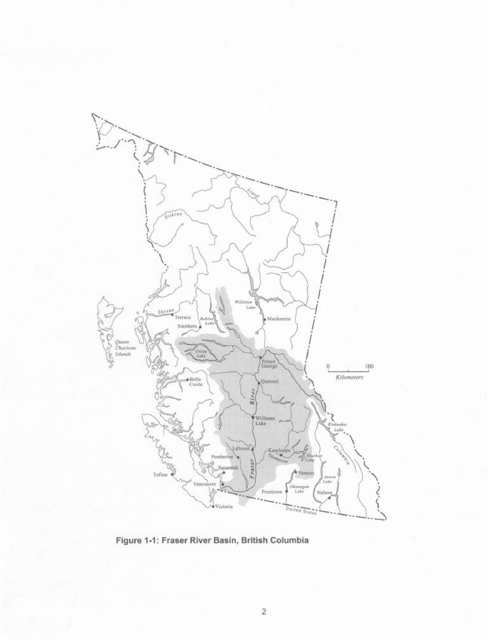
10 Chapter 1: Introduction This chapter presents the major issues relating to this research project. It provides some background and a rationale for the research, contains project objectives and lists the research questions used to guide this investigation. It also relates the project methodology and explains the report organization. 1.1 Background and Project Rationale Ever since the cessation of the nomadic lifestyle, humans have been involved in love-hate relationships with rivers. The same rivers that provide clean water, fertile soils and transportation routes, on occasion deluge flood plain dwellers. For nearly as long as human have settled the flood plain, engineers have been trying to hold back flood waters using various forms of dikes, levees and dams with varying degrees of success. A Chinese engineer, Yu, is credited with the design of the first flood control works on the Hwang Ho River in China during the third century B.C.. However, despite his and future engineers efforts, more than seven million Chinese have been killed by the Hwang Ho s flood waters since 1887 (United States Public Broadcasting Service n.d.a.). Flood catastrophes afflict countries worldwide and Canada has had its share of damaging floods in recent times. In the spring of 1997, Manitoba s Red River surpassed its banks and threatened downtown Winnipeg, and in 1996 the Saguenay River flood waters in Québec left thousands homeless (CNN 1996). The Fraser River In British Columbia, the Lower Fraser Valley in particular, flooding is an equally important issue. The Fraser is a living, dynamic river, approximately 1200 kilometres long, which drains a catchment of close to square kilometres, as seen in Figure 1-1. The Lower Fraser Valley comprises the lowland area near the mouth of the Fraser River, stretching from Hope in the east to the Strait of Georgia in the west. At Hope, the Fraser River is 5 m above sea level and has an average discharge of 2730 m 3 /s. It is joined by several major rivers along the final 160 1

11
12 km stretch, increasing the average discharge to 3700 m 3 /s at the Fraser s mouth. The river is fed primarily by glaciers and snowmelt, and as a consequence, it experiences high flows in late spring and low flows in late winter. The variation in average flows ranges from 500 m 3 /s to m 3 /s at the river s mouth. Historically, during peak flows, excess water would overtop the banks of the Fraser and flood approximately 1000 km 2 of wetlands and swamps adjacent to the river (Healey 1997). The flooding of the Fraser River has affected residents of the region for thousands of years. The Stó:lô Nation, the original inhabitants of the Lower Fraser Basin, has a legend describing a particularly large Fraser River flood. The waters forced the Stó:lô to build rafts to save themselves. They eventually found dry land on what is today called Pointing Thumb Mountain, north of Yale. Remains of their camp high on the mountain are allegedly evident today. The following excerpt describes what the Stó:lô saw once the waters had receded: When they got back, there was nothing left of their homes. Even the house posts had fallen down in the mud. There was no sign of life.... Everything was changed. Some of the creeks that had been there were no more, and there were new lakes and creeks in different places. The people were pretty weak before the salmon came again but that year there was lots of salmon and the people were saved. (Keller 1976) Settlement in the Fraser Valley When colonists arrived at the beginning of the 19 th Century, they settled on the fertile flood plains of the Lower Fraser Valley. As the population grew, so did the demand for land. The newly arrived Europeans drained wetlands and small lakes, and razed forests for farmland, dramatically changing the landscape of the Fraser River Valley. By 1920, approximately 50% of the original forest cover had been removed and 30% of the natural wetlands had been drained in the Lower Fraser Valley (Healey 1997). In order to protect the growing Lower Mainland population and valuable farmland from flood damage, control structures were built. The first known dike along the Fraser River was 3
.")
13 constructed in 1864 on Lulu Island, what is today Richmond (McMullen 1999). Further dikes were built along the length of the Fraser River in an effort to protect valuable crops and settlements from spring floods. The largest recorded flood on the Fraser River occurred in 1894, when discharges of m 3 /s were recorded at Hope. The damages were severe; dikes were breached and overtopped along the length of the Lower Fraser River. Those residing in the flood plain were forced to evacuate to Vancouver. As a result of the flood, the Canadian Pacific Railway line was closed for 41 days. The estimated damage to railway properties alone approached $1 million 1894 dollars. Additionally, much of the Fraser Valley could not support crops that season because fields were covered with silt and debris deposited by the flood (McMullen 1999 and Fraser Basin Management Board 1994). Clearly, this was a major social and economic disaster for the region. Following the 1894 Fraser River flood, it was recognised that a better flood control system was necessary to keep the residents of the Fraser Valley safe. Although the need for action was recognised, no long-lasting policy strategy was established. Over the next fifty years, the population of the region had grown by more than 1000 per cent to over half a million residents, such that when the next major flood occurred in 1948, thousands of businesses and homes were deluged hectares of the Fraser Valley were under water, people were evacuated, and thousands of homes were destroyed. The economic cost of the 1948 flood was estimated at $17.5 million in 1948 dollars (Wynn and Oke 1992; The Fraser Basin Management Board 1994). Following the 1948 Fraser River flood a series of joint Federal-Provincial boards were convened to study issues related to flooding in the region, culminating in the establishment of the Fraser River Board. Its mandate was to rebuild existing dikes, construct new dikes and determine which additional flood control measures would be suitable for the region. In 1968 the board initiated the Fraser River Flood Control Program who between their conception and 1994 spent $300 million (in 1994 dollars) of Federal and Provincial money on dikes, drainage structures and erosion protection along the Lower Fraser River. During the mandate of the program, controversial flood control measures such the damming of the Fraser north of Lillooet were 4

14 discussed and discarded due to the negative environmental impacts to the valuable salmon stocks. From the 1940 s to the 1970 s, the flood management community, championed by University of Chicago professor, Gilbert White, was examining alternatives to structural flood control (White 1961). In the Lower Fraser Valley, structural measures alone were no longer adequate to protect communities. Various small efforts were made to regulate development on the flood plain. The Lower Mainland s 1966 Official Regional Plan delineated the 200-year flood plain, and established that it should not be used for urban development, except where historical settlements already existed. Nevertheless, these Urban Exempt Areas experienced rapid growth over the second half of the century (Fraser Basin Council n.d.). Further measures to restrict growth on the flood plain included Section 82 of the 1979 Land Title Act, requiring that officers of the Ministry of Environment, Lands and Parks (MELP) consent to subdivision developments on the flood plain. MELP subsequently created a Floodplain Development Control Program. Although, it did not generally prohibit development of new subdivisions in flood plains, it did require that the developments be flood-proofed (McMullen 2000). Over the same time period the Canada Water Act (1970) created an opportunity for joint Provincial-Federal water resources planning and structural project construction. Through the National Flood Damage Reduction Program, the Act, provided support for floodplain mapping projects, discouraging development in vulnerable areas. However, B.C. insisted on using this funding for structural works. B.C. did not participate in the Act s floodplain mapping initiative until To date, 545 maps have been completed in the province, yet the Lower Fraser River flood plain has not been well covered (Booth and Quinn 1995). Under this initiative, both Provincial and Federal governments agreed not to invest money in public buildings within the designated flood plains. Furthermore, the governments agreed to provide no financial assistance to owners of flood damaged buildings that were built on the flood plain after designation and if the buildings were not flood proofed to Provincial standards (Day 1999; Peters 2000). 5

15 Despite the movement to implement land use planning and zoning as effective tools for flood damage control, flood control efforts along the Lower Fraser Basin are predominantly structural in nature. Presently, 600 km of dikes, 400 floodboxes and 100 pumps protect over 50 per cent of the Lower Mainland population (B.C. MELP n.d.a.). There are currently 2 million residents in the lower mainland, and it is projected that there will be an additional million in the next 20 years (British Columbia Stats 2000). All these people require living space; space that is constrained by the mountainous nature of the region and puts tremendous development pressure on the valley floor, the Fraser River s flood plain. The existence of Urban Exempt Areas has allowed for continued development in historical flood plain settlements, thus necessitating the building of more structural flood control works. This in turn attracts further developments to the flood plains that will require flood protection. Dr. Jeffrey Mant calls this cycle serial engineering (Friends of the River n.d.). Structural flood works are expensive and require continued maintenance to be effective. In addition, if the structural works fail, economic losses are great. There is currently approximately $13 billion worth of investment on the Lower Fraser Valley flood plains (Fraser Basin Management Board 1994). It is estimated that if a flood of 1894 proportions were to occur today, $1.8 billion of direct flood damage would result. However, this figure does not include many indirect damages such as health costs and lost business time. Additionally, it is widely thought that the figure if $1.8 billion significantly underestimates the true cost of damage that would be incurred. This situation indicates the spiralling costs associated with structural flood control works, as shown graphically in Figure

16 Reduction in perceived vulnerability to flood loss Construction of structural flood control Spiralling costs and environmental degradation Increased floodplain development Increased vulnerability of floodplain development Figure 1-2: Spiralling costs associated with structural flood control The development of the Lower Fraser Valley has significantly affected the natural hydrological regime. Development has increased the surface runoff after precipitation events as a result of replacing permeable ground cover with impermeable surfaces. Additionally, straightening and smoothing of water channels for flood control has the effect of reducing the duration of a flood, but increasing the peak, the maximum volume of water flowing down a channel. This increases the damage that occurs in a flood. Furthermore, structural flood control measures have detrimental environmental effects. For example, the construction of dikes, levees, and dams change in-stream and riparian habitat, creating wildlife concerns. In the United States, structural flood control measures have not been successful at reducing flood damage. In fact, flood damage is on the rise despite the continued expenditure on structural flood control (Hunt 1999). In the Lower Fraser Valley, structural flood damage reduction measures have primarily been a reaction to flooding events. The structures, however, are creating problems, both economically and environmentally. Although they have been effective to date, it is argued that without some changes, a future Fraser River flood could be a natural disaster of unprecedented proportion in Canada (Fraser Basin Council n.d.). This statement illustrates the need for some lateral thinking regarding flood control in B.C., and possibly a move towards 7

17 natural flood control. There is a need to replace reactive structural approaches to flood damage reduction with proactive measures, such as natural approaches to flood damage reduction. A Natural Approach to Flood Damage Reduction The goal of a natural approach to flood damage reduction is getting the landscape to store as much water as possible by returning flood plains to their pre-development state, so that water is gradually released back into streams and rivers. Thus the flood peak is reduced, and the duration lengthened, when compared to the engineered approach. There are numerous advantages to this approach to flood control, including reduced flood and damage risk, long-term economic gain and environmental benefits (Hunt 1997). Hydrologically, restoring wetlands to their natural state is an extremely effective tool for flood damage reduction. However, it requires the procurement of large areas of economically valuable riparian land to be successful. The acquisition of this land requires policy tools supported by the local political and social climate. In Canada, government policy has not actively promoted nonstructural approaches to flood damage reduction (Day 1999). Although, there are numerous reasons to adopt a non-structural approach to flood control in the Lower Fraser Valley, at this time it is unclear how this could be achieved. There is a need to research policy options and implications and to assess which policies would be the most appropriate to move B.C. from a reactive dependence on structures and emergency measures to a proactive approach to flood damage reduction. 1.2 Project Objectives The aim of this research project is to examine the suitability of integrating a natural approach to flood damage reduction in the Lower Fraser Valley, B.C. into existing structural policies. A variety of policy options are examined to establish which policies would be most effective in promoting a natural approach to flood damage reduction in B.C.. Figure 1-3 summarizes the project, where the question mark indicates the various policy options and legislation that can be used to achieve a move from structural to natural approaches to flood damage reduction. 8
.")
18 Reduction in perceived vulnerability to flood loss Decreased flood risk for riparian developments through flood and flow control Construction of structural flood control Spiralling costs and environmental degradation Increased floodplain development Return floodplain to natural (undeveloped) state Decreased long-term financial costs Increased vulnerability of floodplain development Environmental and social benefits Figure 1-3: Structural and natural flood damage reduction options. 1.3 Research Questions This paper examines the suitability and opportunity for a non-structural approach to flood damage reduction in the Lower Fraser Valley, B.C.. Four research questions have been developed to guide the research. Providing answers to the following research questions will permit central research question to be answered with confidence. 1. What is natural flood control? 2. What flood policy is currently in place in British Columbia? 3. What policy options are available to achieve natural flood control? 4. How can natural flood control be achieved in British Columbia? 1.4 Project Methods The development of this research project involved the use of varying methods over two principal stages. The first stage involved a review of relevant literature pertaining to the topics addressed by the project. The project s methods in the second stage involved a complete analysis of Federal, Provincial and Municipal legislation as it pertains to non-structural adjustments to flooding. 9

19 1.5 Report Organisation This document is divided into five chapters. Chapter 1 has presented the rationale for the project, the purpose of the study, research questions and a brief description of the research methods used in this project. Chapter 2 provides a comprehensive look at structural and nonstructural flood control including an extensive literature review of these topics. Chapter 3 presents a thorough look at adjustments to flood control, once again citing published literature. Chapter 4 presents and analyses existing Federal, Provincial and Municipal legislation that pertains to flood management. Finally, Chapter 5 presents conclusions and recommendations regarding a non-structural approach to flood damage reduction in the Lower Fraser Valley. 10

20 Chapter 2: Flooding and Flood Damage Reduction: Natural Versus Structural Approaches To control flooding, we need to work with the forces of nature, instead of simply trying to eliminate them. (Haeuber and Michener 1998a) This chapter examines structural and natural approaches to flood damage reduction through a hydrological discussion of natural and altered landscapes. It also discusses long and short-term social, economic and environmental benefits of a natural approach to flood control. 2.1 What is flooding? Flooding is a natural process that occurs when the quantity of water in a watershed exceeds the capacity of streams, rivers, and lakes. In wide valleys such as in the Lower Fraser Valley, excess water flows out onto flood plains adjacent to these bodies of water. It is only since man has chosen to inhabit what the river bottom occasionally claims that conflict has arisen between the natural process of flooding and anthropogenic development. This section briefly examines the hydrology of flooding and explains methods used to mitigate damage Flood Plains The flood plain is the lowland area adjacent to a river. It can be both dry and wet; the amount of time the flood plain is under water will depend on local circumstances. Flood plains form over long periods as a river channel meanders across a valley bottom depositing rocks and silt on the outside of river bends. This dynamic river movement creates flat landscapes of silt on both sides of the river channel, called flood plains. Extensive flood plains, as shown in Figure 2-1, are found in the Lower Fraser Valley. 11

21
22 Generally, the channel capacity is great enough to carry the flow of water, although during certain weather events excess water will spread out onto adjacent flood plains. In a natural system, this water remains on the flood plain for a short time where it plays a vital role in the natural cycle. Many of these roles are discussed later in this chapter. The flood water will recede when the capacity in the system is great enough to carry it away Floods A flood is any relatively high flow that overtops the natural or artificial banks in any reach of a stream or river (Chow 1964). There are three major types of riparian flood occurrences in Canada: flash floods, spring freshets, ice jams and glacier-outburst floods (Andrews 1993). British Columbia is prone to spring freshet floods that occur when the snow pack melts, sending large volumes of water down mountain valleys into waterways, and often onto flood plains. Both the 1894 and 1948 Fraser River floods occurred during the spring when rain added to the snowmelt already in the river system caused flood plain inundation (Andrews 1993) Flood Damage Reduction People fear floods only because they have chosen to live on flood plains that would without control measures be inundated. There are two major approaches to reducing the damage caused by floods. Either, people and infrastructure can be removed from the water, or the water can be diverted away from the people. Structural measures to move water include: dams, levees and dikes reservoirs and retarding basins channel modification catchment modification drainage schemes 13
23 flood proofing of vulnerable properties (Penning-Roswell and Peerbolte 1994) Structural flood control measures are mankind s way of attacking natural challenges. Large and impressive engineering structures are perceived to provide protection from natural flooding events. As problems are realized with structural flood control measures, scientists and engineers are examining less aggressive, proactive options to flood control. Examples of nonstructural measures to mitigate flood damage include: flood forecasting, flood warning and emergency planning land use planning controls acquisition and relocation flood insurance Public information and education (Penning-Roswell and Peerbolte 1994). Land use planners and engineers have traditionally preferred to redirect water with large structures rather than removing people from vulnerable regions. There are numerous reasons why this approach is not suitable for current development and climatic conditions. The natural approach to flood damage reduction as described in this paper combines moving people with moving water. The advantages and disadvantages of this method are discussed later in the chapter. 2.2 Flood Damage Reduction A Structural Approach The B.C. approach to flood damage reduction has primarily been structural. 600 km of dikes, 400 flood boxes and 100 pump stations protect residents of the Lower Mainland (B.C. MELP n.d.a.; Peters 2000). Structural works can be successful at mitigating flood damage by holding back flood water from inhabited flood plains. However, long and short-term problems associated with the use of structural flood works are evident today. 14
Lower Raritan Watershed Management Area Stormwater & Flooding Subcommittee Strategy Worksheet LRSW-S3C1
 Strategy Name: Reduce Existing Potential for Flood Damages LRSW-S3C1. Develop and implement a program to: Minimize flood damages through the use of structural measures. Minimize flood damages through the
Flood Risk Management
 Flood Risk Management Value of Flood Risk Management Every year floods sweep through communities across the United States taking lives, destroying property, shutting down businesses, harming the environment
Flood Risk Management
 Flood Risk Management Value of Flood Risk Management Value to Individuals and Communities Every year floods sweep through communities across the United States taking lives, destroying property, shutting
Flash Flood Science. Chapter 2. What Is in This Chapter? Flash Flood Processes
 Chapter 2 Flash Flood Science A flash flood is generally defined as a rapid onset flood of short duration with a relatively high peak discharge (World Meteorological Organization). The American Meteorological
Flooding Hazards, Prediction & Human Intervention
 Page 1 of 10 EENS 3050 Tulane University Natural Disasters Prof. Stephen A. Nelson Flooding Hazards, Prediction & Human Intervention This page last updated on 19-Oct-2015 Hazards Associated with Flooding
Flooding Fast Facts. flooding), seismic events (tsunami) or large landslides (sometime also called tsunami).
, seismic events (tsunami) or large landslides (sometime also called tsunami).") Flooding Fast Facts What is a flood? Flooding is the unusual presence of water on land to a depth which affects normal activities. Flooding can arise from: Overflowing rivers (river flooding), Heavy rainfall
Flooding Fast Facts What is a flood? Flooding is the unusual presence of water on land to a depth which affects normal activities. Flooding can arise from: Overflowing rivers (river flooding), Heavy rainfall
Post-Flood Assessment
 Page 1 of 7 Post-Flood Assessment CHAPTER 4 AGENCY COORDINATION Agency coordination is an essential element for the operation of the flood management systems in the Central Valley. Due to the nature of
FLOOD PROTECTION AND ECOSYSTEM SERVICES IN THE CHEHALIS RIVER BASIN. May 2010. Prepared by. for the. 2010 by Earth Economics
 FLOOD PROTECTION AND ECOSYSTEM SERVICES IN THE CHEHALIS RIVER BASIN May 2010 Prepared by for the Execubve Summary The Chehalis Basin experienced catastrophic flooding in 2007 and 2009. In response, the
Burnt River Black River and Gull River Flood Contingency Plan
 Burnt River Black River and Gull River Flood Contingency Plan Objective: The objective of this plan is to preplan and prepare for flooding events in the Burnt River, Black River and Gull River area of
STAFF REPORT TO COMMITTEE OF THE WHOLE
 STAFF REPORT TO COMMITTEE OF THE WHOLE DATE: November 7 2012 TO: FROM: SUBJECT: ATTACHMENT(S): COMMITTEE OF THE WHOLE GINA LAYTE-LISTON, SUPERVISOR, WASTEWATER Stormwater Management Funding Strategy None
LYNDE CREEK WATERSHED EXISTING CONDITIONS REPORT CHAPTER 12 - STORMWATER MANAGEMENT
 Whitby CLOCA Whitby CLOCA LYNDE CREEK WATERSHED EXISTING CONDITIONS REPORT CHAPTER 12 - STORMWATER MANAGEMENT June 2008 TABLE OF CONTENTS 1.0 INTRODUCTION... 3 2.0 STUDY AREA AND SCOPE... 4 3.0 METHODOLOGY...
Floodplain Connectivity in Restoration Design
 Floodplain Connectivity in Restoration Design 2015 Symposium on Restoration in a Contaminated Environment: Lessons Learned and Challenges in Moving Forward Part II April 2015 Karin Boyd Applied Geomorphology,
FLOOD PROTECTION BENEFITS
 IV. (340 points) Flood Protection Benefits A. Existing and potential urban development in the floodplain (50) 1. Describe the existing and potential urban development at the site and the nature of the
Chehalis River Basin Flood Damage Reduction 2013-2015 Capital Budget Approved by Legislature in June 2013
 Chehalis River Basin Flood Damage Reduction 2013-2015 Capital Budget Approved by Legislature in June 2013 1. Design alternatives for large capital flood projects (basinlevel water retention and Interstate
BLACK/HARMONY/FAREWELL CREEK WATERSHED EXISTING CONDITIONS REPORT CHAPTER 12 - STORMWATER MANAGEMENT
 Harmony Creek subwatershed Harmony Creek subwatershed BLACK/HARMONY/FAREWELL CREEK WATERSHED EXISTING CONDITIONS REPORT CHAPTER 12 - STORMWATER MANAGEMENT April 2011 TABLE OF CONTENTS 1.0 INTRODUCTION...
BRITISH COLUMBIA S FLOOD MANAGEMENT POLICY WINDOW CAN WE TAKE ADVANTAGE?
 4 th International Symposium on Flood Defence: Managing Flood Risk, Reliability and Vulnerability Toronto, Ontario, Canada, May 6-8, 2008 BRITISH COLUMBIA S FLOOD MANAGEMENT POLICY WINDOW CAN WE TAKE ADVANTAGE?
ECONOMIC ANALYSIS FLOOD DAMAGE REDUCTION. Lower Carmel River Floodplain Restoration and Enhancement Project
 ECONOMIC ANALYSIS FLOOD DAMAGE REDUCTION Lower Carmel River Floodplain Restoration and Enhancement Project I. Description of the Project and its Relationship to Other Projects in the Proposal The Lower
INDONESIA - LAW ON WATER RESOURCES,
 Environment and Development Journal Law LEAD INDONESIA - LAW ON WATER RESOURCES, 2004 VOLUME 2/1 LEAD Journal (Law, Environment and Development Journal) is a peer-reviewed academic publication based in
Interim Technical Guidelines for the Development of Environmental Management Plans for Underground Infrastructure Revised - July 2013.
 Interim Technical Guidelines for the Development of Environmental Management Plans for Underground Infrastructure Revised - July 2013 Rationale Underground infrastructure may be at risk from valley, streambank
Henry Van Offelen Natural Resource Scientist MN Center for Environmental Advocacy hvanoffelen@mncenter.org
 Henry Van Offelen Natural Resource Scientist MN Center for Environmental Advocacy hvanoffelen@mncenter.org Wetland study slide Water Quality NRE goals in watershed plans Protect habitat that remains.
3. The submittal shall include a proposed scope of work to confirm the provided project description;
 QIN Shoreline Master Program Project Summary The Shoreline Master Program (SMP) development process for the Quinault Indian Nation (QIN) includes the completion of inventory and analysis report with corresponding
5.0 OVERVIEW OF FLOOD DAMAGE REDUCTION MEASURES
 5.0 OVERVIEW OF FLOOD DAMAGE REDUCTION MEASURES Flood damage reduction consists of two basic techniques structural and non-structural. Structural methods modify the flood and take the flood away from people
COMPREHENSIVE PLAN SECTION B, ELEMENT 4 WATER RESOURCES. April 20, 2010 EXHIBIT 1
 COMPREHENSIVE PLAN SECTION B, ELEMENT 4 WATER RESOURCES April 20, 2010 EXHIBIT 1 ELEMENT 4 WATER RESOURCES TABLE OF CONTENTS 4.1 INTRODUCTION 4.2 GOALS AND POLICIES 4.2.A General Goals and Policies 1 4.2.B
Detention Ponds. Detention Ponds. Detention Ponds. Detention Ponds. Detention Ponds. Detention Ponds. CIVL 1112 Detention Ponds - Part 1 1/12
 CIVL 1112 - Part 1 1/12 The water cycle, also known as the hydrologic cycle, describes the continuous movement of water on, above and below the surface of the Earth. The water cycle, also known as the
The correct answers are given below. Some talking points have been added for the teachers use.
 Natural Resources Canada 2011: Lesson Plan Grades 11 and 12 Landslide activity 5b: Landslides in Canada quiz Description: This is an independent study activity for grades 11 and 12. Students will read
Swannanoa River Flood Risk Management Study
 Swannanoa River Flood Risk Management Study Measures Evaluated to Reduce Future Flood Damages City of Asheville U.S. Army Corps of Engineers Flooding History Part of the 132 square mile Swannanoa River
Background Information: The Mamquam River Floodplain Restoration Project
 Background Information: The Mamquam River Floodplain Restoration Project The Mamquam River Floodplain Restoration project is being undertaken in partnership with the Squamish River Watershed Society, Fisheries
Flood After Fire Fact Sheet
 FACT SHEET Flood After Fire Fact Sheet Risks and Protection Floods are the most common and costly natural hazard in the nation. Whether caused by heavy rain, thunderstorms, or the tropical storms, the
Estimating Potential Reduction Flood Benefits of Restored Wetlands
 Estimating Potential Reduction Flood Benefits of Restored Wetlands Kenneth W. Potter University of Wisconsin Introduction Throughout the summer of 1993 a recurring question was the impact of wetland drainage
A. Flood Management in Nevada
 Nevada Division of Water Planning A. Flood Management in Nevada Introduction Flooding has been a concern for Nevada communities since the first settlers moved to the territory in the mid-1800 s. Fourteen
Water Security Agency. Plan for 2015-16. saskatchewan.ca
 Water Security Agency Plan for 2015-16 saskatchewan.ca Statement from the Minister I am pleased to present the Water Security Agency s Plan for 2015-16. The Honourable Scott Moe Minister Responsible for
Standard Operating Procedures for Flood Preparation and Response
 Standard Operating Procedures for Flood Preparation and Response General Discussion Hurricanes, tropical storms and intense thunderstorms support a conclusion that more severe flooding conditions than
The Hydrologic Cycle. precipitation evaporation condensation transpiration infiltration surface runoff transport groundwater water table.
 The Hydrologic Cycle Page 1 of 1 Name Directions: The hydrologic cycle consists of the processes that change and move water through the earth s system. Use the terms below to label the hydrologic cycle.
Addendum D. Nomination of Moody Wash ACEC
 Addendum D Nomination of Moody Wash ACEC Moody Wash ACEC is hereby nominated by Citizens for Dixie s Future to: BLM St. George Field Office 345 East Riverside Drive St. George, UT 84790 Moody Wash is a
1.7.0 Floodplain Modification Criteria
 1.7.0 Floodplain Modification Criteria 1.7.1 Introduction These guidelines set out standards for evaluating and processing proposed modifications of the 100- year floodplain with the following objectives:
Discussion about the practicability of implementing flood risk. management and urban flood insurance in China. Longhua Gao, Xiaoqing Zhou
 Discussion about the practicability of implementing flood risk management and urban flood insurance in China Longhua Gao, Xiaoqing Zhou Abstract: This paper explains the flood risk management at first,
General Permit for Activities Promoting Waterway - Floodplain Connectivity [working title]
![General Permit for Activities Promoting Waterway - Floodplain Connectivity [working title]](/thumbs/39/18645965.jpg "General Permit for Activities Promoting Waterway - Floodplain Connectivity [working title]") General Permit for Activities Promoting Waterway - Floodplain Connectivity [working title] Purpose These rules set forth the conditions under which a person may, without an individual removal-fill permit
General Permit for Activities Promoting Waterway - Floodplain Connectivity [working title] Purpose These rules set forth the conditions under which a person may, without an individual removal-fill permit
How To Plan A Buffer Zone
 Backyard Buffers Protecting Habitat and Water Quality What is a buffer? A buffer (also called a riparian buffer area or zone) is the strip of natural vegetation along the bank of a stream, lake or other
Environmental Case Study Decatur, Georgia, DeKalb County A Suburban Creek Resists Channelization
 Introduction A visual examination of Doolittle Creek in a highly developed suburban county in Georgia yielded telltale signs of a creek whose original streambed had been altered. Examination of official
Flood Mitigation Efforts in the Red River Basin. Slobodan P. Simonovic University of Manitoba University of Western Ontario
 Flood Mitigation Efforts in the Red River Basin Slobodan P. Simonovic University of Manitoba University of Western Ontario Presentation outline Introduction Red River basin experience legislation structural
IUCN Guidelines to Avoid Impacts of Water Resources Projects on Dams and Other Water Infrastructure
 IUCN Guidelines to Avoid Impacts of Water Resources Projects on Dams and Other Water Infrastructure (December 2013) IUCN does not engage in projects which involve the design, construction or rehabilitation
COMMUNITY CERTIFICATIONS
 National Flood Insurance Program Community Rating System COMMUNITY CERTIFICATIONS Public reporting burden for this form is estimated to average 4 hours for annual recertification, per response. The burden
A Developer s Guide: Watershed-Wise Development
 A Developer s Guide: Watershed-Wise Development Environmental Protection What is a watershed? It does not matter how far away you build from a creek, lake, or the ocean, you are in a watershed. Another
Clean Water Services. Ecosystems Services Case Study: Tualatin River, Washington
 Viewed broadly, the concept of ecosystem services describes the many resources and services provided by nature. Typically, traditional planning and development practices do not adequately represent the
Responding to the Challenges of Water Security: the VIII Phase of the International Hydrological Programme 2014-2021
 3rd UNECWAS Annual Seminar 21st of August, TUT Responding to the Challenges of Water Security: the VIII Phase of the International Hydrological Programme 2014-2021 Blanca Jimenez-Cisneros Director of the
Integrated Water and Sediment Management of Yellow River
 Keeping Health Life of Yellow River: Integrated Water and Sediment Management of Yellow River Shang Hongqi Yellow River Conservancy Commission 18 March 2009 Istanbul, Turkey Outline: I. Yellow River Characteristic
GLOSSARY OF TERMS CHAPTER 11 WORD DEFINITION SOURCE. Leopold
 CHAPTER 11 GLOSSARY OF TERMS Active Channel The channel that contains the discharge Leopold where channel maintenance is most effective, sediment are actively transported and deposited, and that are capable
Chapter 3 CULVERTS. Description. Importance to Maintenance & Water Quality. Culvert Profile
 Chapter 3 CULVERTS Description A culvert is a closed conduit used to convey water from one area to another, usually from one side of a road to the other side. Importance to Maintenance & Water Quality
Pajaro River Watershed Integrated Regional Water Management Plan Update Project Solicitation Form
 Pajaro River Watershed Integrated Regional Water Management Plan Update PROJECT OVERVIEW General Project Information Project Title: Corralitos Creek Water Supply and Fisheries Enhancement Project Project
SUSTAINABLE URBAN DRAINAGE SYSTEMS
 overflow can lead into a permeable conveyance system to increase further the benefit and reduce the need for pipe systems. Pollutant removal rates have been shown to be high, with some pollutants being
Frequently Asked Questions (FAQs) on Hydropower
 on Hydropower") Frequently Asked Questions (FAQs) on Hydropower What are the advantages of Hydropower? A renewable source of energy - saves scarce fuel reserves. Non-polluting and hence environment friendly. Long life
Frequently Asked Questions (FAQs) on Hydropower What are the advantages of Hydropower? A renewable source of energy - saves scarce fuel reserves. Non-polluting and hence environment friendly. Long life
The River Ribble is one of the longest rivers in the North West of England
 River Ribble The River Ribble is one of the longest rivers in the North West of England Did you know? The tidal limit of the Ribble is 11 miles inland (above Preston); The River Ribble is home to a variety
4. Environmental Impacts Assessment and Remediation Targets
 4. Environmental Impacts Assessment and Remediation Targets 4.1 Environmental Impacts Significant additional development in the Alder Creek watershed is not anticipated at this time; however, there are
RESTORING streams to reduce flood loss
 RESTORING streams to reduce flood loss Flood Loss Reduction the Natural Way Flood disasters have become a regular Floods can devastate local occurrence. One in your community may have communities. threatened
URBAN DRAINAGE CRITERIA
 URBAN DRAINAGE CRITERIA I. Introduction This division contains guidelines for drainage system design and establishes a policy for recognized and established engineering design of storm drain facilities
CHAPTER 3A Environmental Guidelines for STREAM CROSSING BY ALL-TERRAIN VEHICLES
 GOVERNMENT OF NEWFOUNDLAND AND LABRADOR DEPARTMENT OF ENVIRONMENT AND LABOUR CHAPTER 3A Environmental Guidelines for STREAM CROSSING BY ALL-TERRAIN VEHICLES WATER RESOURCES MANAGEMENT DIVISION Water Investigations
Prattsville Berm Removal Project. 1.0 Project Location
 Prattsville Berm Removal Project 1.0 Project Location The project site is located between the New York State Route 23 Bridge over the Schoharie Creek and the Schoharie Reservoir. The restoration plan encompassed
Summary: Introduction
 Summary: Melbourne Water has a range of responsibilities in the Port Phillip and Westernport region, including responsibilities for the protection and restoration of waterways and, in collaboration with
Victorian Floods 2011: Frequently Asked Questions
 Victorian Floods 2011: Frequently Asked Questions Prepared by DSE with contribution from relevant agencies. PLANNING FOR FLOODS Why did this flood happen? Floods are often seen as unexpected natural disasters,
Outlet stabilization structure
 Overview of Sedimentation and Erosion Control Practices Practice no. 6.41 Outlet stabilization structure Erosion at the outlet of channels, culverts, and other structures is common, and can cause structural
7.0 Stream Restoration
 7.0 Stream Restoration 7.1 Issue Statements One of the primary concerns of residents in the Bassett Creek watershed is the maintenance of the natural beauty of the creek in residential and recreational
Objective 4: Enhanced community education, flood awareness and preparedness
 Objective 4: Enhanced community education, flood awareness and preparedness Understanding the extent and full impacts of flooding is essential for planning for potential future pressures on the drainage
Hydrologic Engineering Techniques for Regional Water Resources Planning
 US Army Corps of Engineers Hydrologic Engineering Center Hydrologic Engineering Techniques for Regional Water Resources Planning October 1969 Approved for Public Release. Distribution Unlimited. TP-17
Multi-Jurisdictional Hazard Mitigation Plan
 Flooding General Flooding is the leading cause of death among all types of natural disasters throughout the United States, with its ability to roll boulders the size of cars, tear out trees, and destroy
The Basics of Chapter 105 Waterways and Wetlands Permitting in PA
 The Basics of Chapter 105 Waterways and Wetlands Permitting in PA April 17, 2013 Goal To develop a basic understanding of PA Department of Environmental Protection (DEP) and US Army Corps of Engineers
Catchment Scale Processes and River Restoration. Dr Jenny Mant Jenny@therrc.co.uk. The River Restoration Centre therrc.co.uk
 Catchment Scale Processes and River Restoration Dr Jenny Mant Jenny@therrc.co.uk The River Restoration Centre therrc.co.uk 3 Main Catchment Elements Hydrology Energy associated with the flow of water affects
FLOOD FORECASTING PRACTICE IN NORTHERN CALIFORNIA
 FLOOD FORECASTING PRACTICE IN NORTHERN CALIFORNIA California Department of Water Resources Post Office Box 219000, Sacramento, California 95821 9000 USA By Maurice Roos, Chief Hydrologist ABSTRACT Although
The AIR Inland Flood Model for the United States In Spring 2011, heavy rainfall and snowmelt produced massive flooding along the Mississippi River,
 The AIR Inland Flood Model for the United States In Spring 2011, heavy rainfall and snowmelt produced massive flooding along the Mississippi River, inundating huge swaths of land across seven states. As
1 Introduction. 1.1 Key objective. 1.2 Why the South Esk
 1 Introduction 1.1 Key objective The aim of this study is to identify and assess possible options for improving the quality of the river channel and habitats in the River South Esk catchment whilst helping
EU China River Basin Management Programme
 Ministry of Water Resources Ministry of Environmental Protection EU China River Basin Management Programme Technical Report 075 Water Resource Supply Security Strategy Analysis Ben Piper, Zhang Wang and
Appendix H Dredging and Stream Channel Restoration
 Appendix H Dredging and Stream Channel Restoration Mankind s intrusion into the natural environment in West Virginia began in earnest following the Civil War when extractive industries and settlement all
Global Water Resources
 Global Water Resources Highlights from assessment activities over the past two decades, which are used to establish present and future water trends, reveal that: 1. Freshwater resources are unevenly distributed,
Protecting Floodplain. While Reducing Flood Losses
 Protecting Floodplain Natural and Beneficial i Functions While Reducing Flood Losses Jon Kusler Association of State Wetland Managers 518 872 1804; jon.kusler@aswm.org Report available at: http://aswm.org/pdf_lib/nbf.pdf
River Wensum Restoration Strategy Swanton Morley Restoration Scheme Reach 14a
 River Wensum Restoration Strategy Swanton Morley Restoration Scheme Reach 14a At a glance River restoration benefits: Improved planform, channel cross-section, flow variation and sediment process. Improved
Environmental Restoration - Flood Plains vs Potholes
 Environmental Restoration - Flood Plains vs Potholes Jerry L. Rasmussen Mississippi Interstate Cooperative Resource Association (MICRA) Introduction The 1993 midwest floods clearly demonstrated the folly
Revising the Nantahala and Pisgah Land Management Plan Preliminary Need to Change the Existing Land Management Plan
 Revising the Nantahala and Pisgah Land Management Plan Preliminary Need to Change the Existing Land Management Plan Throughout the Plan 1. There is a fundamental need for the revised plan to address how
Tropical Storm Allison
 Tropical Storm Allison June 13, 2003, 2:41PM Two years after Allison, Houston has reached a watershed moment By KEVIN SHANLEY Houston is exploding with growth. But city building can be a messy business,
Flood Emergency Response Planning: How to Protect Your Business from a Natural Disaster RIC005
 Flood Emergency Response Planning: How to Protect Your Business from a Natural Disaster RIC005 Speakers: Tom Chan, CEO, Global Risk Miyamoto Greg Bates, Principal, Global Risk Consultants Learning Objectives
How To Fix A Creek In Sandon
 Valhalla Wilderness Society Box 329, New Denver, British Columbia, Canada V0G 1S0 Phone: (250) 358-2333, Fax: (250) 358-7950, E-mail: vws@vws.org, Web: http://www.vws.org Robyn Roome Regional Director,
11.4 Voluntary Purchase. 11.5 House Raising and Flood Proofing
 11.4 Voluntary Purchase As mentioned in Section 10 in certain high hazard areas of the floodplain, it may be impractical or uneconomic to mitigate flood hazard to existing properties at risk, or flood
Methods for Determination of Safe Yield and Compensation Water from Storage Reservoirs
 US Army Corps of Engineers Hydrologic Engineering Center Methods for Determination of Safe Yield and Compensation Water from Storage Reservoirs October 1966 Approved for Public Release. Distribution Unlimited.
Water Extraction Permitting Policy
 Water Extraction Policy 1 Water Extraction Permitting Policy Department of Environment, Labour & Justice January 2013 Water Extraction Policy 2 EXECUTIVE SUMMARY This document establishes a new policy
FINAL TECHNICAL MEMORANDUM AWD-00002 FLOWS THROUGH FLOOD DAMAGE REDUCTION AREA July 16, 2012
 FINAL TECHNICAL MEMORANDUM AWD-00002 FLOWS THROUGH FLOOD DAMAGE REDUCTION AREA July 16, 2012 Table of Contents TABLE OF CONTENTS Table of Contents... 1 Executive Summary... 2 1 Objective... 4 2 Study Approach...
Healthy Forests Resilient Water Supply Vibrant Economy. Ecological Restoration Institute
 Healthy Forests Resilient Water Supply Vibrant Economy Ecological Restoration Institute How Water Gets to Your Home MOST OF THE VALLEY S WATER SUPPLY comes from winter precipitation and runoff from Arizona
Sustainability Brief: Water Quality and Watershed Integrity
 Sustainability Brief: and Watershed Integrity New Jersey depends on water resources for the health of our people, the strength of our economy, and the vitality of our ecosystems. The quality of our water
Earth Science. River Systems and Landforms GEOGRAPHY 1710. The Hydrologic Cycle. Introduction. Running Water. Chapter 14.
 Earth Science GEOGRAPHY 1710 River Systems and Landforms DAVID R. SALLEE Robert W. Christopherson Charlie Thomsen Chapter 14 Introduction Rivers and streams are dynamic systems that continually adjust
The Planning Process. 1 O WOW 1.0 Plan Moving Towards Sustainability
 The Planning Process The development of this One Water One Watershed (OWOW) 2.0 Plan is built upon the planning process of the past to address the challenges of the future. The first phase of OWOW, known
LEAGUE NOTES ON APPROVED COMMUNITY WATER SUPPLY PLAN
 1 AUGUST 2011 LEAGUE NOTES ON APPROVED COMMUNITY WATER SUPPLY PLAN KEY ELEMENTS OF THE PLAN: 1. Replace the existing unsafe Ragged Mountain dam with a new dam and raise the reservoir pool level initially
Assiniboine River and Lake Manitoba Basins Flood Mitigation Study: Providing Greater Protection For Manitobans From Flood Risks
 Assiniboine River and Lake Manitoba Basins Flood Mitigation Study: Providing Greater Protection For Manitobans From Flood Risks Welcome! Manitoba Infrastructure and Transportation is studying flooding
Resolving complex issues with large scale river restoration; a case study: the San Joaquin River in California
 IWA Publishing 2011 Water Practice & Technology Vol 6 No 4 doi:10.2166/wpt.2011.074 Resolving complex issues with large scale river restoration; a case study: the San Joaquin River in California William
SCHNEIDER CREEK REMEDIATION CLASS ENVIRONMENTAL ASSESSMENT ADDENDUM
 SCHNEIDER CREEK REMEDIATION CLASS ENVIRONMENTAL ASSESSMENT ADDENDUM PUBLIC MEETING FEBRUARY 8 TH, 2012 The City of Kitchener and Grand River Conservation Authority (GRCA) are undertaking an Environmental
REPORT TO REGIONAL WATER SUPPLY COMMISSION MEETING OF WEDNESDAY, SEPTEMBER 4, 2013 LEECH WATER SUPPLY AREA RESTORATION UPDATE
 Making a difference... together Agenda Item #9 REPORT #RWSC 2013-17 REPORT TO REGIONAL WATER SUPPLY COMMISSION MEETING OF WEDNESDAY, SEPTEMBER 4, 2013 SUBJECT LEECH WATER SUPPLY AREA RESTORATION UPDATE
RE: Docket # COE 2010 0035; ZRIN 0710 ZA05 Submitted via email to NWP2012@usace.army.mil and Rulemaking Portal at www.regulations.gov.
 April 18, 2011 U.S. Army Corps of Engineers Attn: CECW CO R 441 G Street, N.W. Washington, DC 20314 1000 RE: Docket # COE 2010 0035; ZRIN 0710 ZA05 Submitted via email to NWP2012@usace.army.mil and Rulemaking
APPLICATION OF GEOSPATIAL TECHNOLOGIES FOR SUSTAINABLE ENVIRONMENTAL MANAGEMENT
 APPLICATION OF GEOSPATIAL TECHNOLOGIES FOR SUSTAINABLE NATURAL RESOURCES AND ENVIRONMENTAL MANAGEMENT IN MALAYSIA By James Dawos Mamit, Ph.D. Deputy Minister Ministry of Natural Resources and Environment,
AN INITIATIVE TO IMPROVE
 L OW E R C A R M E L R I V E R A N D L AG O O N F L O O D P L A I N R E S TO R AT I O N A N D E N H A N C E M E N T P R O J E C T AN INITIATIVE TO IMPROVE FLOOD PROTECTION RESTORE AND PROTECT RIPARIAN
Flooding and Flood Threats on Trenton Island
 Mitigation Success Trenton Island, Pierce County, Wisconsin Background: Trenton Island is located in the unincorporated area of Trenton Township, Pierce County, in northwestern Wisconsin. Often called
Stormwater management around the world Lessons from Novatech 2010 Dennis Corbett and Marion Urrutiaguer
 Stormwater management around the world Lessons from Novatech 2010 Dennis Corbett and Marion Urrutiaguer Novatech 2010, the 7th international conference on sustainable techniques and strategies in urban
CITY OF HIGHLAND PARK, ILLINOIS Stormwater Management Fact Sheet
 CITY OF HIGHLAND PARK, ILLINOIS Stormwater Management Fact Sheet WHAT IS STORMWATER MANAGEMENT? Stormwater management is the method for channeling rainfall through pipes and sewers away from property to
Recommendations for future developments
 C Recommendations for future developments C.1 Reducing flood risk through site layout and design C.1.1 C.1.2 Flood risk should be considered at an early stage in deciding the layout and design of a site
Restoration Planning and Development of a Restoration Bank
 Restoration Planning and Development of a Restoration Bank Black Creek Pioneer Village, South Theatre 8:30 a.m. to 3:30 p.m. Habitat Restoration and Environmental Monitoring Projects Section Restoration