POLAR ICE Integrated Arctic and Antarctic Sea Ice monitoring Services
|
|
|
- Damian Warren
- 7 years ago
- Views:
Transcription

1 VTT TECHNICAL RESEARCH CENTRE OF FINLAND LTD Place for a photo (no lines around photo) Photo: Tapio Nyman POLAR ICE Integrated Arctic and Antarctic Sea Ice monitoring Services Robin Berglund, Lauri Seitsonen, Teppo Veijonen VTT Technical Research Centre of Finland Ltd Marko Mäkynen, Finnish Meteorological Institute Finnish Remote Sensing Days, November 23, 2015


2 The POLAR ICE Project Consortium

3 POLAR ICE is focused on Arctic and Antarctic Economically and environmentally important Arctic retreat of the sea ice during the last two decades facilitating increase in natural resource development Accompanied by increased shipping activity. The Antarctic also seeing increased ship traffic driven by fisheries, cruise ships and scientific research POLAR ICE project scheduled to finish in June 2016 Arctic Sea Ice extent, Sept Source: National Snow and Ice Data Center, Boulder, CO

4
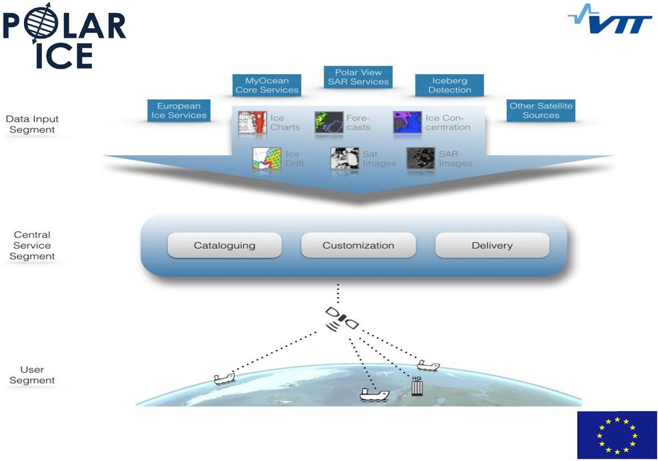
5 Integrated Arctic & Antarctic sea-ice monitoring services 1. Advanced sea ice information products Sea-ice thickness Sea-ice pressure Sea-ice forecasts 2. Focus on Integration & visualisation: Bringing together our products AND many more Operational service integration Onboard integration and visualisation 3. End User Demonstrations 4. Business analysis Shipping, Oil and Gas, Fishing, Coast Guard, Ice service, Oil Spill, Tourism, Icebergs, Science, Engineering

6 Advanced sea ice information products Sea-ice thickness Sea-ice pressure Sea-ice forecasts Ice thickness very important for transport Hard to obtain with satellites 3 products: FMI, Bremen, NR Integration nick.walker@eosphere.co.uk


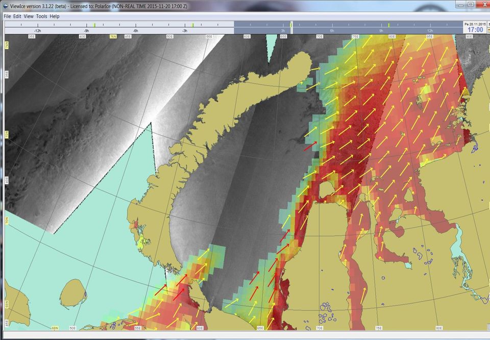
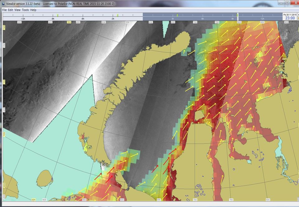
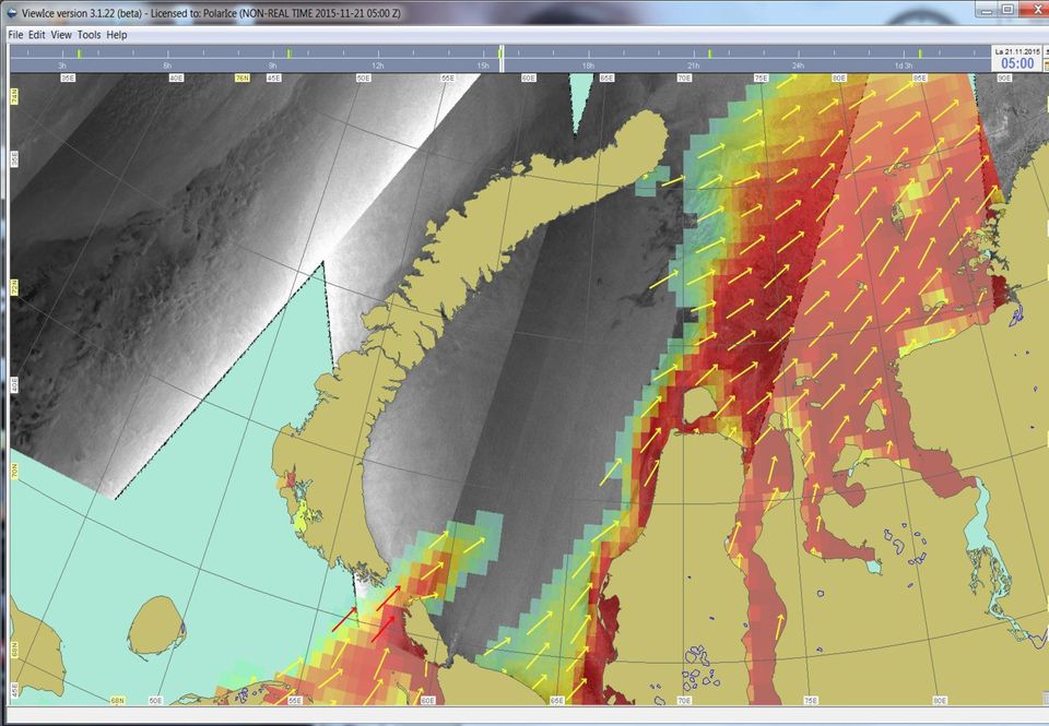
7 Chart on 19 Nov 2015 POLAR ICE - FMI sea ice thickness chart Satellite data used: AMSR2 radiometer and Sentinel-1 EW SAR. (EW= Extra Wide) Radiometer data gives thin ice areas, thickness up to 30 cm. Copernicus CMEMS TOPAZ model gives background ice thickness field which is locally modulated by SAR backscatter statistics. FYI thickness up to 2.5 m. Pixel size 1 km. Coverage: Barents and Kara Seas. Issued now from Nov 2015 to April 2016 (cold conditions needed). Submitted to POLAR ICE daily. Further development on-going.

8 Advanced sea ice information products Sea-ice thickness Sea-ice pressure Sea-ice forecasts Ice pressure very important Derived from ice drift information Ice drift derived from subsequent satellite data acquisitions by DTU

9 Advanced sea ice information products Sea-ice thickness Sea-ice pressure Sea-ice forecasts Ice forecasts very Ice thickness, concentration, divergence important for route planning Derived from a model with several inputs Can examine parameters at a point Can step forward in time Example: Ice concentration forecast in the Kara Sea nick.walker@eosphere.co.uk

10

11
12
13
14
15

16

17
18

19

20

21
22
23
24
25 Advanced sea ice information products Sentinel-1 data is very important within POLAR ICE SAR data is at the heart of many ice products and ice analysis
26 Harmonising colors Several providers of ice products -> can be confusing to the users UNLESS the color coding is harmonised Providers reluctant to change their production processes -> have to adapt to the coding conventions used by the providers A set of rules is defined per product type -> identifies Categories and Physical values Bremen Sea ice conc. image DTU AMSR2 ice conc. image 22/04/
27 Colouring Colour Products Interpretation Rendered layers tables Ice concentration chart Categories Numerical ice model Quantitative values 22/04/
28 Example: Ice concentration 20 November 2015 Ice concentration forecast (by DMI) Ice concentration from AMSR 2 (by Bremen University) Ice concentration from AMSR 2 (by DTU) 22/04/
29 Testing POLAR ICE during a seismic survey in the Greenland Sea 23 August to 20 September 2015 The Finnish icebreaker Otso was assisting nick.walker@eosphere.co.uk
30 Testing POLAR ICE during a seismic survey in the Greenland Sea 23 August to 20 September 2015 The DMI Ice Advisory Team: Jens Jakobsen, Anne Marie Findsen and Martin Nissen POLAR ICE running on one of the workstations installed on the Otso bridge nick.walker@eosphere.co.uk
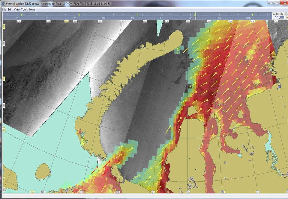
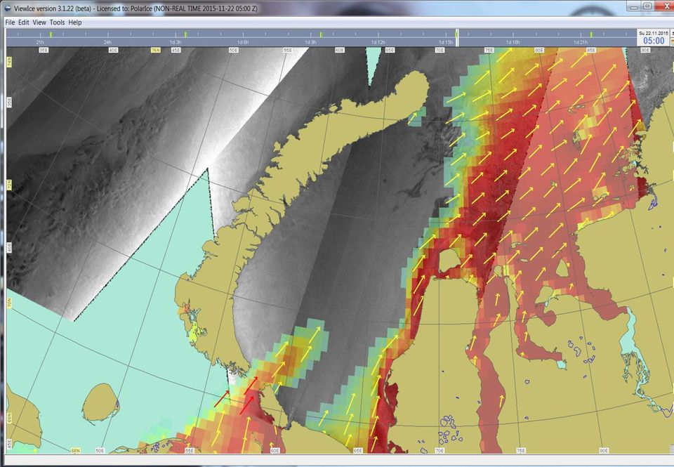
31 The ViewIce system showing Sentinel-1 SAR imagery. The NE Greenland license blocks are displayed on top of the Sentinel image from 15th September Testing POLAR ICE during a seismic survey in the Greenland Sea 23 August to 20 September 2015 nick.walker@eosphere.co.uk
32 The former land fast ice is expected to drift towards east. Especially in the northern part of the survey area, the ice regime is forecasted to be displaced towards east, from 15th Sep. to 16 Sep. The survey managed just to finish seismic acquisition in the northern part of the survey area before the former land fast ice actually encroached towards the area. Testing POLAR ICE during a seismic survey in the Greenland Sea 23 August to 20 September 2015 nick.walker@eosphere.co.uk
 POLAR")

33 Testing POLAR ICE: Vessel returning from US West coast (Seattle) to Hammerfest in Norway Route and sea ice concentration (19 Nov 2015) POLAR ICE system is both onboard Tor Viking II and at the company office in Norway
34 Testing POLAR ICE: Vessel returning from US West coast (Seattle) to Hammerfest in Norway Route planning in ViewIce based on SENTINEL-1 image
35 Testing POLAR ICE: Fishing in the Antarctic December - January Patagonian tooth fish caught in Antarctic annually under license Small mobile vessels with strong requirement for tactical ice information Information for navigation: Maximising the catch When & where to enter the ice Where to deploy lines Where to go next Safety & avoiding getting trapped Ross Sea ice pack nick.walker@eosphere.co.uk
36 Testing POLAR ICE: Fishing in the Antarctic December - January And may move here in the Amundsen Sea Usually start here in the Ross Sea SAR data very very useful nick.walker@eosphere.co.uk

37 TECHNOLOGY FOR BUSINESS
Arctic HSE seminar 1. Ice behavior in northern regions, availability and need for metocean & ice data. Paul Verlaan 24 th March 2014
 Arctic HSE seminar 1 Ice behavior in northern regions, availability and need for metocean & ice data. Paul Verlaan 24 th March 2014 DEFINITIONS & CAUTIONARY NOTE Reserves: Our use of the term reserves
GREENLAND COMMAND. Rear Admiral Henrik Kudsk
 GREENLAND COMMAND Rear Admiral Henrik Kudsk Maritime Safety in the Arctic factors, capabilities new challenges. Agenda: Greenland Greenland Command. The Search and Rescue task. Resources for Search and
e-navigation and Geospatial Intelligence for Maritime Operations; Developing a Strategic Vision Digital Ship Athens 2014
 e-navigation and Geospatial Intelligence for Maritime Operations; Developing a Strategic Vision Digital Ship Athens 2014 Michael Rambaut for John Erik Hagen, Regional Director NCA Coordinator of IMO Correspondence
How To Find Natural Oil Seepage In The Dreki Area Using An Envisat Image
 rn ORKUSTOFNUN National Energy Authority Searching for natural oil seepage in the Dreki area using ENVISAT radar images. Ingibjorg J6nsd6ttir and Arni Freyr Valdimarsson, Faculty of Earth Sciences School
THE IMPROVEMENT OF WINTER NAVIGATION WITH RISK-BASED APPROACHES Tapio Nyman VTT Industrial Systems tapio.nyman@vtt.fi
 THE IMPROVEMENT OF WINTER NAVIGATION WITH RISK-BASED APPROACHES Tapio Nyman VTT Industrial Systems tapio.nyman@vtt.fi ICE DAY Basics of Winter Navigation in the Baltic Sea 11th and 12th February, 2004
A little on Marine Core Services
 A little on Marine Core Services Copernicus Services -> CLOSE WATCH -> RELIABLE and UP-TO-DATE information 6 thematic areas: Land Monitoring Operational Emergency Management Operational Atmosphere Monitoring
METIER Course No. 6: Remote Sensing & Hydrosphere Helsinki 6 November 2008 Kati Tahvonen Finnish Environment Institute
 The Use of Remote Sensing, Drifting Forecasts and GIS Data in Oil Response and Pollution Monitoring METIER Course No. 6: Remote Sensing & Hydrosphere Helsinki 6 November 2008 Kati Tahvonen Finnish Environment
International Collaboration required to develop Arctic shipping. 5 July 2016 President & CEO Tero Vauraste Arctia Ltd.
 International Collaboration required to develop Arctic shipping 5 July 2016 President & CEO Tero Vauraste Arctia Ltd. Contents 1) Arctic Economic Council 2) Finland in the Arctic Economic Council 3) Team
Finnish Marine Research Infrastructure FINMARI
 Finnish Marine Research Infrastructure FINMARI Lauri Laakso, Finnish Meteorological Institute Timo Tamminen, Finnish Environment Institute Finnish Meteorological Institute 1. National roadmap for key research
Temporal variation in snow cover over sea ice in Antarctica using AMSR-E data product
 Temporal variation in snow cover over sea ice in Antarctica using AMSR-E data product Michael J. Lewis Ph.D. Student, Department of Earth and Environmental Science University of Texas at San Antonio ABSTRACT
High Resolution SAR Data to Support Polar Operations
 High Resolution SAR Data to Support Polar Operations Tuomas Niskanen Development Manager / Senior Ice Specialist Finnish Ice Service, Oceanographic Services Finnish Meteorological Institute Topics COSMO-SkyMed
From WorldWide to Arctic, challenges and risk
 Resource exploration under extreme Arctic conditions Morten Mejlænder-Larsen, Director Arctic Operations Content Challenges Arctic Risk Class Rules and Notations today International Rules and Notations
Ksat Infrastructure and architecture for Multi-Mission Applications. dr. Kris Nackaerts dr. Martin Krynitz dr. Jan Petter Pedersen
 Ksat Infrastructure and architecture for Multi-Mission Applications dr. Kris Nackaerts dr. Martin Krynitz dr. Jan Petter Pedersen Riyadh, 2016 Tromsø Capital of space activities in the North Tromsø Capital
Monitoring of Arctic Conditions from a Virtual Constellation of Synthetic Aperture Radar Satellites
 DISTRIBUTION STATEMENT A. Approved for public release; distribution is unlimited. Monitoring of Arctic Conditions from a Virtual Constellation of Synthetic Aperture Radar Satellites Hans C. Graber RSMAS
E-navigation, process, results, status and delivery
 E-navigation, process, results, status and delivery Chile, October 2013 John Erik Hagen, Regional Director NCA Coordinator of IMO Correspondence Group on e-navigation Shipping moves into the digital world
Statoil s Arctic program, Bear Island nature reserve and the ice edge May 12, 2014
 Statoil s Arctic program, Bear Island nature reserve and the ice edge May 12, 2014 Media Brief WHAT: Statoil is preparing to drill the northernmost well ever drilled on the Norwegian continental shelf,
Monitoring of Arctic Conditions from a Virtual Constellation of Synthetic Aperture Radar Satellites
 DISTRIBUTION STATEMENT A. Approved for public release; distribution is unlimited. Monitoring of Arctic Conditions from a Virtual Constellation of Synthetic Aperture Radar Satellites Hans C. Graber RSMAS
Sodankylä National Satellite Data Center (NSDC): Current and Future Satellite Missions and Products
: Current and Future Satellite Missions and Products") Sodankylä National Satellite Data Center (NSDC): Current and Future Satellite Missions and Products Timo Ryyppö, CSPP Users Group Meeting 2015 Content Introduction to Sodankylä site Facilities Satellites
Sodankylä National Satellite Data Center (NSDC): Current and Future Satellite Missions and Products Timo Ryyppö, CSPP Users Group Meeting 2015 Content Introduction to Sodankylä site Facilities Satellites
Space radar technologies for oil spills management, detection of illegal fishing and logging activities
 Space radar technologies for oil spills management, detection of illegal fishing and logging activities VIGISAT The French satellite ground receiving station VIGISAT 2009 know today, live better tomorrow
Japan s Arctic Policies with regards to Maritime Law and Jurisdictional Issues
 1 Japan s Arctic Policies with regards to Maritime Law and Jurisdictional Issues Prof T Ikeshima LLB, LLM, DES, PhD Waseda University 2 Outline Introduction: geographical background Japan s interests and
Antarctic summer sea ice concentration and extent: comparison of ODEN 2006 ship observations, satellite passive microwave and NIC sea ice charts
 The Cryosphere, 3, 1 9, 2009 Author(s) 2009. This work is distributed under the Creative Commons Attribution 3.0 License. The Cryosphere Antarctic summer sea ice concentration and extent: comparison of
The Fram Centre Research in the high north under innovative structure
 The Fram Centre Research in the high north under innovative structure December 2014 Nina Mari Jørgensen, Norwegian Polar Institute Photo: Jo Aarseth, Kongsfjorden, Svalbard August 2013 Governmental support
ERS-l ICE MONITORING OF THE NORTHERN SEA ROUTE
 ERS-l ICE MONITORING OF THE NORTHERN SEA ROUTE 143 Ola M. Johannessen, Stein Sandven, Lasse H. Pettersson, Martin W. Miles, Kjell Kloster Nansen Environmental andremote Sensing Center Edvard Griegsvei
Nordic-Baltic-American Cooperation in the Arctic: A United States View
 Chapter 17 Nordic-Baltic-American Cooperation in the Arctic: A United States View Lawson W. Brigham The 21 st century Arctic is dominated by change and complexity. Globalization, climate change, regional
Ice thickness in the Beaufort Sea and Northwest Passage in April 2016, and comparison with April 2015
 Ice thickness in the Beaufort Sea and Northwest Passage in April 2016, and comparison with April 2015 Christian Haas, Anne Bublitz, Alec Casey, Justin Beckers, York University, Toronto, Canada Contact:
Remote sensing for operational pollution monitoring, source detection and identification. Frascati, Italy 14 th /15 th September 2010
 Remote sensing for operational pollution monitoring, source detection and identification Frascati, Italy 14 th /15 th September 2010 Content Technique & methodology for monitoring and detection Oil slick
The European Space Agency s Synthetic Aperture Radar Programme From Experiment to Service Provision
 The European Space Agency s Synthetic Aperture Radar Programme From Experiment to Service Provision Evert Attema ESA, Directorate of Earth Observation Programme! The idea of an independent European space
Lundin Norway Our visions and strategies as a leading company in the Norwegian part of the Barents Sea
 Lundin Norway Our visions and strategies as a leading company in the Norwegian part of the Barents Sea by Bernt Rudjord, HSEQ Manager, Lundin Norway AS 1 Joint MARPART-SEBS Conference, Murmansk 9 April
U.S. Coast Guard. America s Maritime Guardian
 U.S. Coast Guard America s Maritime Guardian Nov. 2009 A few armed vessels, judiciously stationed at the entrances of our ports, might at a small expense be made useful sentinels of the laws. Alexander
Baltic Sea Perspective on - Building a Gas Pipeline and - Oil Spills
 Baltic Sea Perspective on - Building a Gas Pipeline and - Oil Spills Dr Juha-Markku Leppänen Head of the Monitoring and Assessment Unit, Marine Research Centre, Finnish Environment Institute (SYKE) Content
WATERWAYS in Finland
 WATERWAYS in Finland The efficient and economical running of Finland s vital international transport demands a comprehensive and safe network of fairways. The mission of the Finnish Maritime Administration
Safety Challenges in the Arctic
 Safety Challenges in the Arctic International Conference on Integrated Operations in the Petroleum Industry Trondheim, 25.09.13 Børre Johan Paaske, DNV GL Agenda Defining the Arctic Safety and environmental
Maritime Safety and Security
 Maritime Safety and Security - A Priority Area of the EU Strategy for the Baltic Sea Region Actions and activities in the Baltic Sea Region to secure a leading role in maritime safety and security The
Advances in Arctic Oil-Spill Mitigation, Response Measures and Clean-up Techniques
 Advances in Arctic Oil-Spill Mitigation, Response Measures and Clean-up Techniques Vince Mitchell St John s Newfoundland 28 May 2013 Looking Forward LNXG 1000 Skimming System Animation Present day status
Nenad Mladineo. Marko Mladineo. Marin Stosic
 Nenad Mladineo University of Split, Faculty of Civil Engineering, Architecture and Geodesy, Croatia mladineo@gradst.hr Marko Mladineo University of Split, Faculty of Electrical Engineering, Mechanical,
Satellite Derived Dynamic Ocean Currents in the Arctic. Jens Olaf Pepke Pedersen Polar DTU / DTU Space www.polar.dtu.dk www.space.dtu.
 Satellite Derived Dynamic Ocean Currents in the Arctic Jens Olaf Pepke Pedersen Polar DTU / DTU Space www.polar.dtu.dk www.space.dtu.dk Benefits of exploiting ocean currents Benjamin Franklins map of the
Oil Spill Preparedness and Response: The Singapore Experience
 Oil Spill and : The Singapore Experience Capt M Segar Assistant Chief Executive (Operations) Maritime and Port Authority of Singapore Scope Introduction MPA s Strategy in Combating Oil Spill Regional Cooperation
Captain J. Ashley Roach, JAGC, USN (retired) Office of the Legal Adviser, U.S. Department of State (retired) Global Associate, CIL NUS Singapore
 Office of the Legal Adviser, U.S. Department of State (retired) Global Associate, CIL NUS Singapore") Captain J. Ashley Roach, JAGC, USN (retired) Office of the Legal Adviser, U.S. Department of State (retired) Global Associate, CIL NUS Singapore Panel III: Arctic Shipping Scandic Ørnen Hotel, Bergen,
Captain J. Ashley Roach, JAGC, USN (retired) Office of the Legal Adviser, U.S. Department of State (retired) Global Associate, CIL NUS Singapore Panel III: Arctic Shipping Scandic Ørnen Hotel, Bergen,
CANADA AND THE NORTH INSUFFICIENT SECURITY RESOURCES THEN AND NOW
 CANADA AND THE NORTH INSUFFICIENT SECURITY RESOURCES THEN AND NOW Prepared by: Colonel (Retired) Pierre Leblanc 9 August 2011 BACKGROUND In the late 1990 s I was the Commander of the Canadian Forces in
Baltic Marine Environment Protection Commission
 Baltic Marine Environment Protection Commission Response Working Group Brussels, Belgium, 1-3 June 2015 RESPONSE 20-2015 Document title Arctic oil recovery exercise KEMI ARCTIC 2015 Code 11-1 Category
Therefore, this is a very important question, which encourages consideration of the current management of the resource.
 Aalisarnermut, Piniarnermut Nunalerinermullu Naalakkersuisoqarfik Department of Fisheries, Hunting and Agriculture Finn's speech to NAFMC Climate change in the North Atlantic has become a reality which
Henry Hudson by Kelly Hashway
 Before planes, people traveled by boat. And getting goods from one place to another took a long time, especially when ships had to sail around continents. In the early 1600s, European trading companies
Sea Ice Data Banking
 World Meteorological Organization Commission for Marine Meteorology Steering group for the WMO Project Global Digital Sea Ice Data Bank (GDSIDB), Subgroup on Sea Ice (SGSI). Report of the 6 th Session
Finnish Meteorological Institute s Services for Insurance Sector
 Finnish Meteorological Institute s Services for Insurance Sector Regional training workshop Role of the NMHSs in support of DRR- related activities in the field of insurance Janne Miettinen, Account Manager,
Kirkenes 04-01-08 14:16 Side 1 PORT OF KIRKENES THE GATEWAY TO THE BARENTS SEA AND THE NORTHERN SEA ROUTE A PLACE FOR BUSINESS AND PLEASURE
 Kirkenes 04-01-08 14:16 Side 1 PORT OF KIRKENES THE GATEWAY TO THE BARENTS SEA AND THE NORTHERN SEA ROUTE A PLACE FOR BUSINESS AND PLEASURE Kirkenes 04-01-08 14:17 Side 2 PORT OF KIRKENES Kirkenes Growth
Maritime Domain Management System
 Maritime Domain Management System A member of the SRT plc group www.srt-marinesystems.com 1 Who is SRT Marine System Solutions? The global leaders in maritime domain VTS, VMS technologies, products and
Marine Emergency Incident Response Breakout Discussion Summary
 Marine Emergency Incident Response Breakout Discussion Summary Background The IICWG began its discussion on Marine Incident Response at IICWG-XIV in 2013 when two scenarios were posed to the group for
Arktis ett svenskt tillväxtområde
 Arktis ett svenskt tillväxtområde Stora Marindagen 2011 5 april 2011 Jim Sandkvist Vice President, Head Maritime Operations SSPA Sweden AB Göran Eriksson Manager, Commercial Operations Offshore & Icebreaking
A safe and reliable full-range electrical supplier
 A safe and reliable full-range electrical supplier Hareid Group Hareid Group consists of several companies, primarily within electrical engineering, installation and service. A cooperation providing you
Marine route optimization. Jens Olaf Pepke Pedersen Polar DTU / DTU Space www.polar.dtu.dk www.space.dtu.dk
 Marine route optimization Jens Olaf Pepke Pedersen Polar DTU / DTU Space www.polar.dtu.dk www.space.dtu.dk Early attempt at route optimization Jens Munk (1579-1628) Tries to find a way to India through
Should UK companies invest in Arctic projects?
 Canada-UK Colloquium Iqaluit 5 th November, 2010 Should UK companies invest in Arctic projects? Dr Dougal Goodman FREng Chief Executive The Foundation for Science and Technology dougal.goodman@foundation.org.uk
THE FUTURE OF THE OCEAN ECONOMY: AN OECD/IFP FORESIGHT PROJECT
 THE FUTURE OF THE OCEAN ECONOMY: EXPLORING THE PROSPECTS FOR EMERGING OCEAN INDUSTRIES TO 2030 AN OECD/IFP FORESIGHT PROJECT BARRIE STEVENS OECD/DSTI Verftskonferansen 2013 Alesund, Norway, 5 th November
Endless Seas. We re there with you.
 MARINECOMMS Endless Seas. We re there with you. Thuraya MarineComms provides merchant shipping, fishing, government, Navy, Coast Guard and leisure users with competitively priced, robust and reliable
Bipolar Atlantic Thermohaline Circulation (BIAC) a IPY proposal coordinated by Tor Gammelsrød Geophysical Institute, University of Bergen
 a IPY proposal coordinated by Tor Gammelsrød Geophysical Institute, University of Bergen") Bipolar Atlantic Thermohaline Circulation (BIAC) a IPY proposal coordinated by Tor Gammelsrød Geophysical Institute, University of Bergen The role of the Thermohaline Circulation (THC) as a driving force
Bipolar Atlantic Thermohaline Circulation (BIAC) a IPY proposal coordinated by Tor Gammelsrød Geophysical Institute, University of Bergen The role of the Thermohaline Circulation (THC) as a driving force
AMSRIce03 Sea Ice Thickness Data
 Notice to Data Users: The documentation for this data set was provided solely by the Principal Investigator(s) and was not further developed, thoroughly reviewed, or edited by NSIDC. Thus, support for
Protecting the environment of the Arctic ecosystem. By Professor Olav Orheim Norwegian Polar Institute
 Protecting the environment of the Arctic ecosystem By Professor Olav Orheim Norwegian Polar Institute Outline What is the Arctic? The Arctic marine environment Key environmental challenges Integrated Management
Newsletter MANAGING DIRECTOR S WELCOME IMPORTANT DATES ISSUE 1 VOLUME 1 YEAR 2015
 ISSUE 1 VOLUME 1 YEAR 2015 MANAGING DIRECTOR S WELCOME Welcome to the inaugural issue of the Polar View newsletter! It is our intention to provide you with these updates on Polar View activities twice
Operations in the Arctic areas? New challenges: Exploration Development Production
 Operations in the Arctic areas? New challenges: Exploration Development Production The oil and gas cycle Life cycle of oil and gas (time) 1) 2) 3) 4) 5) 6) Activity In-house study and get licenses: Find
An exactearth Technical White Paper April 2015. Satellite AIS
 An exactearth Technical White Paper April 2015 Satellite AIS Executive Summary exactearth Ltd (www.exactearth.com) is a private data services company delivering global locationbased maritime vessel tracking
E- LASS results : (EU Martec ULIVES project ) Old Facts became Myths in Arctic Inland Navigation Shipdesign
 Old Facts became Myths in Arctic Inland Navigation Shipdesign") E- LASS results : (EU Martec ULIVES project ) Old Facts became Myths in Arctic Inland Navigation Shipdesign Arctic Countries (Wikipedia) Arctic countries based on countries or countries territories bordering
E- LASS results : (EU Martec ULIVES project ) Old Facts became Myths in Arctic Inland Navigation Shipdesign Arctic Countries (Wikipedia) Arctic countries based on countries or countries territories bordering
The role of technology and knowhow in the sector
 The role of technology and knowhow in the sector Japan-Norway Maritime Offshore Technology Seminar Henrik O. Madsen Numerous drivers for new and improved technology in the Maritime Offshore sector Developments
MEOPAR and Horizon 2020 Neil Gall November 18, 2014
 MEOPAR and Horizon 2020 Neil Gall November 18, 2014 OUR FUTURE DEPENDS ON AN INFORMED RELATIONSHIP WITH THE OCEAN MEOPAR as Network of Centres of Excellence 50 researchers from 13 Canadian universities
Entrepreneurial strategies and organizational renewal within the offshore service vessel industry
 Entrepreneurial strategies and organizational renewal within the offshore service vessel industry Professor Odd Jarl Borch University of Nordland. Lecture University of Stavanger, February 10, 2011 CV
Progress in Creating a Global Polar Metadata Interoperability Network
 Progress in Creating a Global Polar Metadata Interoperability Network Julie E. Friddell Canadian Cryospheric Information Network/Polar Data Catalogue Department of Geography, University of Waterloo Canada
Hull & Machinery insurance when sailing in ice. The Nordic Marine Insurance Plan of 2013 (NMIP) Robert H.Hansen Jens W. Bern. (and remote areas)
 Robert H.Hansen Jens W. Bern. (and remote areas)") Hull & Machinery insurance when sailing in ice (and remote areas) The Nordic Marine Insurance Plan of 2013 (NMIP) Robert H.Hansen Jens W. Bern 1 Background 2 main principles All risk insurance cover Everything
Hull & Machinery insurance when sailing in ice (and remote areas) The Nordic Marine Insurance Plan of 2013 (NMIP) Robert H.Hansen Jens W. Bern 1 Background 2 main principles All risk insurance cover Everything
Data Sets of Climate Science
 The 5 Most Important Data Sets of Climate Science Photo: S. Rahmstorf This presentation was prepared on the occasion of the Arctic Expedition for Climate Action, July 2008. Author: Stefan Rahmstorf, Professor
THE FISHERIES REQUIREMENTS FOR AREA IN RELATION TO SEISMIC ACTIVITIES THE FISHERIES
 THE FISHERIES REQUIREMENTS FOR AREA IN RELATION TO SEISMIC ACTIVITIES THE FISHERIES The fish stocks in the Norwegian sector can be divided into two separate categories: The pelagic species comprise herring,
Working with the human element
 Working with the human element Decision support systems and the human factor E-Navigation Underway Conference 2013 29-31 January 2013 Dr Thomas Porathe Maritime Human Factors Dep. of Shipping and Marine
Energy Outlook: U.S. Arctic Outer Continental Shelf
 Alaska OCS Region Energy Outlook: U.S. Arctic Outer Continental Shelf 5th Symposium on the Impacts of an Ice-Diminishing Arctic on Naval and Maritime Operations July 16-18, 2013 Washington, D. C. Sharon
Istanbul Technical University-Center for Satellite Communications and Remote Sensing (ITU-CSCRS)
") Istanbul Technical University-Center for Satellite Communications and Remote Sensing (ITU-CSCRS) Istanbul Technical University, Center for Satellite Communications and Remote Sensing (ITU-CSCRS) was originally
Istanbul Technical University-Center for Satellite Communications and Remote Sensing (ITU-CSCRS) Istanbul Technical University, Center for Satellite Communications and Remote Sensing (ITU-CSCRS) was originally
SOUTHERN OCEAN CURRENTS. http://www.polar.org/antsun/oldissues2002-2003/sun121502/current.html
 Map from: SOUTHERN OCEAN CURRENTS http://www.polar.org/antsun/oldissues2002-2003/sun121502/current.html FROM: The Antarctic Coastal Current Joanna Gyory, John Cangialosi, Ieng Jo, Arthur J. Mariano, Edward
BMP Guidelines. Environmental Impact Assessment (EIA) report for activities related to hydrocarbon exploration and exploitation offshore Greenland
 report for activities related to hydrocarbon exploration and exploitation offshore Greenland") BMP Guidelines for preparing an Environmental Impact Assessment (EIA) report for activities related to hydrocarbon exploration and exploitation offshore Greenland Danish National Environmental Research
BMP Guidelines for preparing an Environmental Impact Assessment (EIA) report for activities related to hydrocarbon exploration and exploitation offshore Greenland Danish National Environmental Research
USING BIG DATA, SCENARIOS DEVELOPMENT, AND GAME THEORY TO MONITOR, UNDERSTAND AND ADAPT TO CLIMATE CHANGE IN THE CIRCUMPOLAR ARCTIC
 USING BIG DATA, SCENARIOS DEVELOPMENT, AND GAME THEORY TO MONITOR, UNDERSTAND AND ADAPT TO CLIMATE CHANGE IN THE CIRCUMPOLAR ARCTIC Magdalena A K Muir 1 1. Introduction Adaptation to climate change in
USA EEZ & CONTINENTAL SHELF RUSSIA EEZ & CONTINENTAL SHELF CANADA EEZ & CONTINENTAL SHELF GREENLAND (DENMARK) EEZ & CONTINENTAL SHELF
 EEZ & CONTINENTAL SHELF") WHO OWNS THE ARCTIC USA EEZ & CONTINENTAL SHELF RUSSIA EEZ & CONTINENTAL SHELF CANADA EEZ & CONTINENTAL SHELF GREENLAND (DENMARK) EEZ & CONTINENTAL SHELF NORWAY EEZ & CONTINENTAL SHELF ICELAND EEZ & CONTINENTAL
WHO OWNS THE ARCTIC USA EEZ & CONTINENTAL SHELF RUSSIA EEZ & CONTINENTAL SHELF CANADA EEZ & CONTINENTAL SHELF GREENLAND (DENMARK) EEZ & CONTINENTAL SHELF NORWAY EEZ & CONTINENTAL SHELF ICELAND EEZ & CONTINENTAL
Advanced modelling and observing solar radiation of Artic sea-ice-understanding changes and processes (AMORA)
") Advanced modelling and observing solar radiation of Artic sea-ice-understanding changes and processes (AMORA) S. Gerland 1, C. Wang 1, M.A. Granskog 1, M. Nicolaus 2, B. Cheng 3, R. Lei 4, N. Li 4, Z.
Advanced modelling and observing solar radiation of Artic sea-ice-understanding changes and processes (AMORA) S. Gerland 1, C. Wang 1, M.A. Granskog 1, M. Nicolaus 2, B. Cheng 3, R. Lei 4, N. Li 4, Z.
Maritime Domain Awareness: Mapping, Tracking, and Visualization
 Maritime Domain Awareness: Mapping, Tracking, and Visualization Authorized Distributor for: COM DEV USA and exactearth Ltd Proprietary What is Maritime Domain Awareness? Maritime Domain: All areas and
TerraSAR X and TanDEM X satellite missions update & other activities Dana Floricioiu German Aerospace Center (DLR), Remote Sensing Technology
, Remote Sensing Technology") TerraSAR X and TanDEM X satellite missions update & other activities Dana Floricioiu German Aerospace Center (DLR), Remote Sensing Technology Institute, Oberpfaffenhofen, Germany PSTG 2 12 14 June 2012
TerraSAR X and TanDEM X satellite missions update & other activities Dana Floricioiu German Aerospace Center (DLR), Remote Sensing Technology Institute, Oberpfaffenhofen, Germany PSTG 2 12 14 June 2012
Norwegian Coastal Administration Emergency response
 Norwegian Coastal Administration Emergency response The Full City accident- Langesund, July 2009, and Godafoss February 2011 Hvaler Lessons learned Rune Bergstrøm Norway, NCA, response area Geographical
National Snow and Ice Data Center
 National Snow and Ice Data Center This data set (NSIDC-0484), part of the NASA Making Earth System Data Records for Use in Research Environments (MEaSUREs) Program, provides the first comprehensive, high-resolution,
Maritime Human Resources Solutions Seminar. Robert Cadigan President & CEO Newfoundland & Labrador Oil & Gas Industries Association
 Maritime Human Resources Solutions Seminar Robert Cadigan President & CEO Newfoundland & Labrador Oil & Gas Industries Association About NOIA NOIA s mission is to promote development of East Coast Canada
Nansen Center (http://www.nersc.no), Longyearbyen/Bergen, Norway 22. August 2015
, Longyearbyen/Bergen, Norway 22. August 2015") Nansen Environmental and Remote Sensing Center Thormøhlens gate 47 5006 Bergen, NORWAY tlf. +47 55 205800 faks +47 55 205801 admin@nersc.no Media contact: Lasse H. Pettersson tlf +47 932 23 563 lasse.pettersson@nersc.no
Nansen Environmental and Remote Sensing Center Thormøhlens gate 47 5006 Bergen, NORWAY tlf. +47 55 205800 faks +47 55 205801 admin@nersc.no Media contact: Lasse H. Pettersson tlf +47 932 23 563 lasse.pettersson@nersc.no
United States Coast Guard Auxiliary Telecommunications Workshop. USCG Auxillary Communications 1
 United States Coast Guard Auxiliary Telecommunications Workshop USCG Auxillary Communications 1 United States Coast Guard The lead military agency of the Department of Homeland Security (not DOD) A multi-mission
Our Antarctic Facilities
 Our Antarctic Facilities Australian Activities in Antarctica Tony Worby IICWG Chile, October 2014 3 days Macquarie Island Wilkins aerodrome Hobart is Australia s Gateway to East Antarctica and the Southern
Barents 2020. Escape, Evacuation and Rescue of People (EER) Morten Mejlænder-Larsen Bodø 21. November 2012
 Morten Mejlænder-Larsen Bodø 21. November 2012") Escape, Evacuation and Rescue of People (EER) Morten Mejlænder-Larsen History 2007-2012 Norway has North Sea offshore experience, while Russia has Arctic operational experience. The Barents Sea represents
Escape, Evacuation and Rescue of People (EER) Morten Mejlænder-Larsen History 2007-2012 Norway has North Sea offshore experience, while Russia has Arctic operational experience. The Barents Sea represents
Tallink Group - Tallink Silja. Rail Baltica Growth Corridor - RBGC Interregional roundtable
 Tallink Group - Tallink Silja Rail Baltica Growth Corridor - RBGC Interregional roundtable Presentation Company presentation key values Passenger traffic - market areas and figures Cargo traffic - market
Voyage Calculations. The Northern Sea Route
 Henrik Falck Tschudi Shipping Company AS Voyage Calculations The Northern Sea Route TFMS Forum Copenhagen, October 24 th. 2012 TSCHUDI SHIPPING COMPANY AS Tschudi Shipping Company AS is the holding company
Sentinel-1 Mission Overview
 Sentinel-1 Mission Overview Pierre Potin Sentinel-1 Mission Manager, ESA Advanced Course on Radar Polarimetry ESRIN, Frascati, 19 January 2011 Global Monitoring for Environment and Security GMES is established
Tactical Oil Spill Management TOSM APTOMAR.COM
 Tactical Oil Spill Management TOSM APTOMAR.COM TCMS AIRBORNE OFFSHORE NEAR SHORE ONSHORE Operations Room Oil Rig Oil Rig Standby Vesel SECurus Radar Surveillance Aircraft TACTICAL OIL SPILL MANAGEMENT
Satellite monitoring of oil spills in the Mediterranean Sea for 1999-2004
 Satellite monitoring of oil spills in the Mediterranean Sea for 1999-2004 Konstantinos Topouzelis, O. Muellenhoff, G. Ferraro, B. Bulgarelli E.C. Joint Research Centre Institute for the Protection and
27. SEA CHARTS EXERCISES ADMIRALTY GUIDE TO ELECTRONIC CHARTING
 27. SEA CHARTS EXERCISES ADMIRALTY GUIDE TO ELECTRONIC CHARTING 1. Supply the correct multi-word term from those in the brackets: (Electronic Navigational Charts, marine survey data, route planning, positioning
Pipelines and seabed intervention
 Workshop on seabed habitats of environmental concern Jørn Spiten Content Pipeline - route design Seabed Intervention - Trenching - Ploughing - Dredging - Rock installation 2 Pipeline routes 3 Pipeline
Chapter 3: Climate and Climate Change Answers
 Chapter 3: Climate and Climate Change Answers Section A: Climate 1. (a) Explain what each of the following means: (4 x 1 mark) (i) climate the average weather of an area over a 25 30 year period (ii) maritime
MARINE HULL GLOBAL TRADING LIMITS
 MARINE HULL GLOBAL TRADING LIMITS A study of the Institute warranties 1976, American Institute Trade Warranties (1972) and International Navigating Conditions (2003). During this inter-active presentation,
The Impact of GPS Jamming on the Safety of Navigation
 The Impact of GPS Jamming on the Safety of Navigation Dr S Basker, Dr A Grant, Dr P Williams, Dr N Ward Presented to the Civil GPS Service Interface Committee, Savannah GA, 15 September 2008 Presentation
Active and Passive Microwave Remote Sensing
 Active and Passive Microwave Remote Sensing Passive remote sensing system record EMR that was reflected (e.g., blue, green, red, and near IR) or emitted (e.g., thermal IR) from the surface of the Earth.
Kongsberg Maritime Torfinn Kildal, President
 Kongsberg Maritime Torfinn Kildal, President WORLD CLASS through people, technology and dedication Kongsberg Maritime Business Model & Strategic Direction Offshore & Merchant Marine Yachting & Fishery
New Space Capabilities for Maritime Surveillance
 www.dlr.de ESA Blue Growth Marititime College, Cork, Ireland 17.4..2013 New Space Capabilities for Maritime Surveillance Susanne Lehner German Aerospace Center DLR Remote Sensing Technology Institute DLR
APPLICATION OF GIS AND AERIAL THERMAL IMAGE PROCESSING METHODS TO SOLVE ENVIRONMENTAL PROBLEMS OF THE OIL INDUSTRY
 APPLICATION OF GIS AND AERIAL THERMAL IMAGE PROCESSING METHODS TO SOLVE ENVIRONMENTAL PROBLEMS OF THE OIL INDUSTRY László MUCSI Associate professor, University of Szeged, Department of Physical Geography
Towards assimilating IASI satellite observations over cold surfaces - the cloud detection aspect
 Towards assimilating IASI satellite observations over cold surfaces - the cloud detection aspect Tuuli Perttula, FMI + Thanks to: Nadia Fourrié, Lydie Lavanant, Florence Rabier and Vincent Guidard, Météo
16 th IOCCG Committee annual meeting. Plymouth, UK 15 17 February 2011. mission: Present status and near future
 16 th IOCCG Committee annual meeting Plymouth, UK 15 17 February 2011 The Meteor 3M Mt satellite mission: Present status and near future plans MISSION AIMS Satellites of the series METEOR M M are purposed