Cloud fractions and related parameters
|
|
|
- Phyllis Peters
- 8 years ago
- Views:
Transcription
1 Cloud fractions and related parameters Michael Grzegorski, Thomas Wagner, Steffen Beierle, Christian Frankenberg, Christoph von Friedeburg, Jens Hollwedel, Stefan Kraus, Sven Kühl, Fahim M. A. Khokhar, Walburga Wilms-Grabe, Suniti Shangavi and Ulrich Platt.

2 CRUSA

3 Validation and further development of CRUSA Improvement of CRUSA and comparison with other algorithms. Results: The outcome of CRUSA s iterative fix point method are quite good background (cloud free) images The values of CRUSA over ocean are inaccurate (negative values, if the pixel is cloudless; too high values, if the pixel is cloudy) The problems due to using the HSV-colour space.
 images The values of CRUSA over ocean are inaccurate (negative values, if the pixel is")
4 Cloud sensitivity of the PMD-channels Investigation was conducted of The three PMD channels (UV, green and red) Sum of red channel and green channel Sum of red, green and uv channel. Maximum of the three channels (HSV-brightness) Red-green interpolation in RGB-colour space Minimum of the three PMD channels Minimum of the red and the green channel.
 Red-green interpolation in RGB-colour")
5 Iterative fix point method I A iterative fix point method is used to calculate background images: The test was limited to data of Pre-classification: cloudy pixel are removed through threshold-method. Mean of all images. Cutting of clouds through comparison with the last background picture. Mean of all images. The iteration ends, if there are no more changes of the background picture

6 Iterative fix point method II We get cloud free pictures for every day: The mean of them is the result of the iteration. For cloud detection the mean of the cloud free pictures of 30 days is used. A reference picture of maximum cloud is calculated in a similar way. Only one picture for the whole year is used.

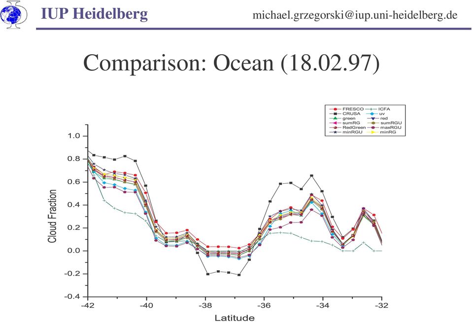
7 Comparison: Ocean ( )
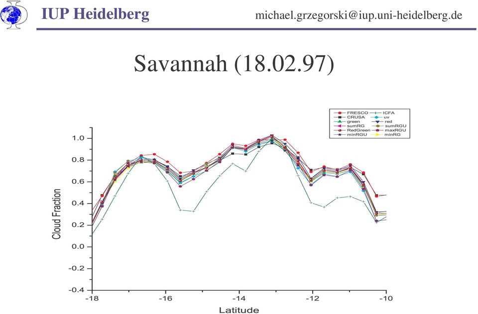
8 Savannah ( )
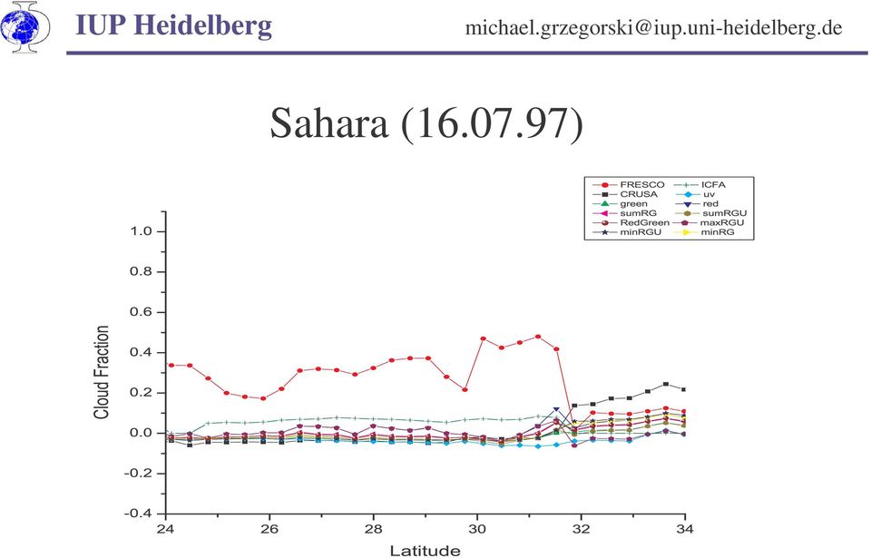
9 Sahara ( )
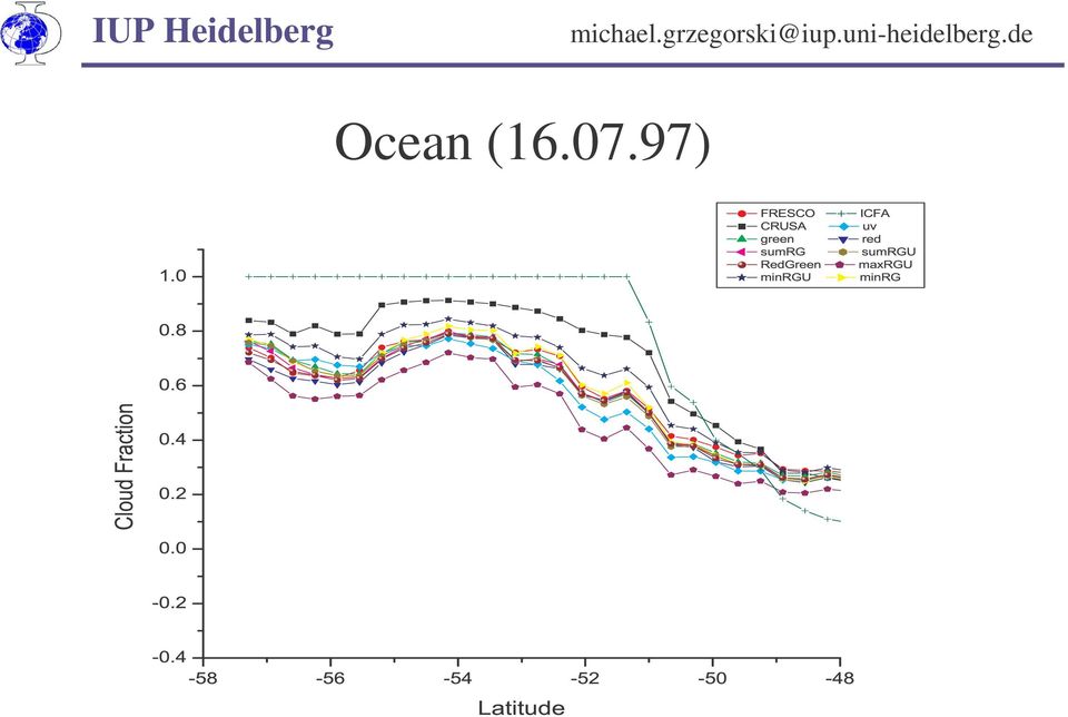
10 Ocean ( )
11 Ukraine, Black Sea ( )
")
12 Rainforest, savannah ( )

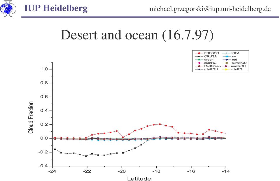
13 Desert and ocean ( )
14 Outlook I Implementation of a new PMD-algorithm to detect fractional cloud cover: We won t use the UV-channel. Improved background iteration: Different iterations for different periods of the year using the whole GOME-Data. Higher spatial resolution

15 Outlook II Improved calculation of maximum cloud further investigation: determination of maximum depends only on solar zenith angle? Quality of maximum cloud data depends strongly on the size of the used dataset. Calculation of cloud top height evaluation of O 4 (630 nm), new cloud fractions and radiation transfer modelling.
, new cloud fractions")
16 The satellite group Heidelberg: Thomas Wagner, Steffen Beirle, Nicolas Dross, Christian Frankenberg, Christoph von Friedeburg, Michael Grzegorski, Jens Hollwedel, Muhammad Fahim Khokhar, Stefan Kraus, Sven Kühl, Suniti Shangavi, Mark Wenig, Walburga Wilms-Grabe, Ulrich Platt

17 ADD-ONs
18 HSV and RGB colour space

19 CRUSA iteration

20 CRUSA interpolation

21 CRUSA
Studying cloud properties from space using sounder data: A preparatory study for INSAT-3D
 Studying cloud properties from space using sounder data: A preparatory study for INSAT-3D Munn V. Shukla and P. K. Thapliyal Atmospheric Sciences Division Atmospheric and Oceanic Sciences Group Space Applications
Measurement of the effect of biomass burning aerosol on inhibition of cloud formation over the Amazon
 Supporting Online Material for Koren et al. Measurement of the effect of biomass burning aerosol on inhibition of cloud formation over the Amazon 1. MODIS new cloud detection algorithm The operational
Volcanic Ash Monitoring: Product Guide
 Doc.No. Issue : : EUM/TSS/MAN/15/802120 v1a EUMETSAT Eumetsat-Allee 1, D-64295 Darmstadt, Germany Tel: +49 6151 807-7 Fax: +49 6151 807 555 Date : 2 June 2015 http://www.eumetsat.int WBS/DBS : EUMETSAT
GOES-R AWG Cloud Team: ABI Cloud Height
 GOES-R AWG Cloud Team: ABI Cloud Height June 8, 2010 Presented By: Andrew Heidinger 1 1 NOAA/NESDIS/STAR 1 Outline Executive Summary Algorithm Description ADEB and IV&V Response Summary Requirements Specification
Cloud Masking and Cloud Products
 Cloud Masking and Cloud Products MODIS Operational Algorithm MOD35 Paul Menzel, Steve Ackerman, Richard Frey, Kathy Strabala, Chris Moeller, Liam Gumley, Bryan Baum MODIS Cloud Masking Often done with
Cloud detection and clearing for the MOPITT instrument
 Cloud detection and clearing for the MOPITT instrument Juying Warner, John Gille, David P. Edwards and Paul Bailey National Center for Atmospheric Research, Boulder, Colorado ABSTRACT The Measurement Of
Data processing (3) Cloud and Aerosol Imager (CAI)
 Cloud and Aerosol Imager (CAI)") Data processing (3) Cloud and Aerosol Imager (CAI) 1) Nobuyuki Kikuchi, 2) Haruma Ishida, 2) Takashi Nakajima, 3) Satoru Fukuda, 3) Nick Schutgens, 3) Teruyuki Nakajima 1) National Institute for Environmental
Data processing (3) Cloud and Aerosol Imager (CAI) 1) Nobuyuki Kikuchi, 2) Haruma Ishida, 2) Takashi Nakajima, 3) Satoru Fukuda, 3) Nick Schutgens, 3) Teruyuki Nakajima 1) National Institute for Environmental
MOD09 (Surface Reflectance) User s Guide
 User s Guide") MOD09 (Surface ) User s Guide MODIS Land Surface Science Computing Facility Principal Investigator: Dr. Eric F. Vermote Web site: http://modis-sr.ltdri.org Correspondence e-mail address: mod09@ltdri.org
MOD09 (Surface ) User s Guide MODIS Land Surface Science Computing Facility Principal Investigator: Dr. Eric F. Vermote Web site: http://modis-sr.ltdri.org Correspondence e-mail address: mod09@ltdri.org
FRESCO. Product Specification Document FRESCO. Authors : P. Wang, R.J. van der A (KNMI) REF : TEM/PSD2/003 ISSUE : 3.0 DATE : 30.05.
 REF : TEM/PSD2/003 ISSUE : 3.0 DATE : 30.05.") PAGE : 1/11 TITLE: Product Specification Authors : P. Wang, R.J. van der A (KNMI) PAGE : 2/11 DOCUMENT STATUS SHEET Issue Date Modified Items / Reason for Change 0.9 19.01.06 First Version 1.0 22.01.06
PAGE : 1/11 TITLE: Product Specification Authors : P. Wang, R.J. van der A (KNMI) PAGE : 2/11 DOCUMENT STATUS SHEET Issue Date Modified Items / Reason for Change 0.9 19.01.06 First Version 1.0 22.01.06
Cloud Climatology for New Zealand and Implications for Radiation Fields
 Cloud Climatology for New Zealand and Implications for Radiation Fields G. Pfister, R.L. McKenzie, J.B. Liley, A. Thomas National Institute of Water and Atmospheric Research, Lauder, New Zealand M.J. Uddstrom
The potential of cloud slicing to derive profile information from Nadir looking instruments
 The potential of cloud slicing to derive profile information from Nadir looking instruments Thomas Wagner, Steffen Beirle, Cheng Liu MPI for Chemistry, Mainz, Germany Pioneering studies (trop. O 3 from
Towards assimilating IASI satellite observations over cold surfaces - the cloud detection aspect
 Towards assimilating IASI satellite observations over cold surfaces - the cloud detection aspect Tuuli Perttula, FMI + Thanks to: Nadia Fourrié, Lydie Lavanant, Florence Rabier and Vincent Guidard, Météo
Partnership to Improve Solar Power Forecasting
 Partnership to Improve Solar Power Forecasting Venue: EUPVSEC, Paris France Presenter: Dr. Manajit Sengupta Date: October 1 st 2013 NREL is a national laboratory of the U.S. Department of Energy, Office
Towards agreed data quality layers for airborne hyperspectral imagery
 Towards agreed data quality layers for airborne hyperspectral imagery M. Bachmann, DLR M. Bachmann, DLR, S. Adar, TAU; E. Ben-Dor, TAU; J. Biesemans, VITO; X. Briottet, ONERA; M. Grant, PML; J. Hanus,
Cloud Oxygen Pressure Algorithm for POLDER-2
 Cloud Oxygen ressure Algorithm for OLDER-2 1/7 Cloud Oxygen ressure Algorithm for OLDER-2 Aim of the : Determination of cloud gen pressure from arent pressure by removing the contribution. Date of the
SAFNWC/MSG Cloud type/height. Application for fog/low cloud situations
 SAFNWC/MSG Cloud type/height. Application for fog/low cloud situations 22 September 2011 Hervé LE GLEAU, Marcel DERRIEN Centre de météorologie Spatiale. Lannion Météo-France 1 Fog or low level clouds?
Data Processing Flow Chart
 Legend Start V1 V2 V3 Completed Version 2 Completion date Data Processing Flow Chart Data: Download a) AVHRR: 1981-1999 b) MODIS:2000-2010 c) SPOT : 1998-2002 No Progressing Started Did not start 03/12/12
REMOTE SENSING OF CLOUD-AEROSOL RADIATIVE EFFECTS FROM SATELLITE DATA: A CASE STUDY OVER THE SOUTH OF PORTUGAL
 REMOTE SENSING OF CLOUD-AEROSOL RADIATIVE EFFECTS FROM SATELLITE DATA: A CASE STUDY OVER THE SOUTH OF PORTUGAL D. Santos (1), M. J. Costa (1,2), D. Bortoli (1,3) and A. M. Silva (1,2) (1) Évora Geophysics
THE USE OF THE HIGH RESOLUTION VISIBLE IN SAFNWC/MSG CLOUD MASK
 THE USE OF THE HIGH RESOLUTION VISIBLE IN SAFNWC/MSG CLOUD MASK Marcel Derrien, Hervé Le Gléau, Marie-Paule Raoul METEO-FRANCE, Centre de Météorologie Spatiale, Avenue de Lorraine, BP 50547, Lannion, France
VIIRS-CrIS mapping. NWP SAF AAPP VIIRS-CrIS Mapping
 NWP SAF AAPP VIIRS-CrIS Mapping This documentation was developed within the context of the EUMETSAT Satellite Application Facility on Numerical Weather Prediction (NWP SAF), under the Cooperation Agreement
Computer Vision: Machine Vision Filters. Computer Vision. Optical Filters. 25 August 2014
 Computer Vision Optical Filters 25 August 2014 Copyright 2001 2014 by NHL Hogeschool, Van de Loosdrecht Machine Vision BV and Klaas Dijkstra All rights reserved j.van.de.loosdrecht@nhl.nl, jaap@vdlmv.nl,
Multiangle cloud remote sensing from
 Multiangle cloud remote sensing from POLDER3/PARASOL Cloud phase, optical thickness and albedo F. Parol, J. Riedi, S. Zeng, C. Vanbauce, N. Ferlay, F. Thieuleux, L.C. Labonnote and C. Cornet Laboratoire
High-accuracy ultrasound target localization for hand-eye calibration between optical tracking systems and three-dimensional ultrasound
 High-accuracy ultrasound target localization for hand-eye calibration between optical tracking systems and three-dimensional ultrasound Ralf Bruder 1, Florian Griese 2, Floris Ernst 1, Achim Schweikard
Labs in Bologna & Potenza Menzel. Lab 3 Interrogating AIRS Data and Exploring Spectral Properties of Clouds and Moisture
 Labs in Bologna & Potenza Menzel Lab 3 Interrogating AIRS Data and Exploring Spectral Properties of Clouds and Moisture Figure 1: High resolution atmospheric absorption spectrum and comparative blackbody
Integrating the Solar Spectrum
 Integrating the Solar Spectrum PHYS 4400, Principles and Varieties of Solar Energy Instructor: Randy J. Ellingson The University of Toledo January 24, 203 Pop Quiz Note: quiz does not count toward grade
METEOSAT 8 SEVIRI and NOAA AVHRR Cloud Products. A Climate Monitoring SAF Comparison Study. Meteorologi. Sheldon Johnston and Karl-Göran Karlsson
 Nr 127, 2007 Meteorologi METEOSAT 8 SEVIRI and NOAA AVHRR Cloud Products A Climate Monitoring SAF Comparison Study Sheldon Johnston and Karl-Göran Karlsson Cover Image The difference between the mean cloudiness
ARM SWS to study cloud drop size within the clear-cloud transition zone
 ARM SWS to study cloud drop size within the clear-cloud transition zone (GSFC) Yuri Knyazikhin Boston University Christine Chiu University of Reading Warren Wiscombe GSFC Thanks to Peter Pilewskie (UC)
REMOTE SENSING OF CLOUD ALBEDO FROM BACKSCATTERED SUNLIGHT IN CLOUDY ATMOSPHERE
 REMOTE SENSING OF CLOUD ALBEDO FROM BACKSCATTERED SUNLIGHT IN CLOUDY ATMOSPHERE A. Hünerbein, R. Preusker and J. Fischer Freie Universität Berlin, Institut für Weltraumwissenschaften Carl-Heinrich-Becker-Weg
Monitoring of Arctic Conditions from a Virtual Constellation of Synthetic Aperture Radar Satellites
 DISTRIBUTION STATEMENT A. Approved for public release; distribution is unlimited. Monitoring of Arctic Conditions from a Virtual Constellation of Synthetic Aperture Radar Satellites RSMAS Department of
SAMPLE MIDTERM QUESTIONS
 Geography 309 Sample MidTerm Questions Page 1 SAMPLE MIDTERM QUESTIONS Textbook Questions Chapter 1 Questions 4, 5, 6, Chapter 2 Questions 4, 7, 10 Chapter 4 Questions 8, 9 Chapter 10 Questions 1, 4, 7
RESULTS FROM A SIMPLE INFRARED CLOUD DETECTOR
 RESULTS FROM A SIMPLE INFRARED CLOUD DETECTOR A. Maghrabi 1 and R. Clay 2 1 Institute of Astronomical and Geophysical Research, King Abdulaziz City For Science and Technology, P.O. Box 6086 Riyadh 11442,
2.3 Spatial Resolution, Pixel Size, and Scale
 Section 2.3 Spatial Resolution, Pixel Size, and Scale Page 39 2.3 Spatial Resolution, Pixel Size, and Scale For some remote sensing instruments, the distance between the target being imaged and the platform,
A comparison of NOAA/AVHRR derived cloud amount with MODIS and surface observation
 A comparison of NOAA/AVHRR derived cloud amount with MODIS and surface observation LIU Jian YANG Xiaofeng and CUI Peng National Satellite Meteorological Center, CMA, CHINA outline 1. Introduction 2. Data
Outline. Case Study over Vale do Paraiba 11 February 2012. Comparison of different rain rate retrievals for heavy. Future Work
 Outline Short description of the algorithms for rain rate retrievals from passive microwave radiometers on board low-orbiting satellites (i.e., SSMI/S) Case Study over Vale do Paraiba 11 February 2012
MSG-SEVIRI cloud physical properties for model evaluations
 Rob Roebeling Weather Research Thanks to: Hartwig Deneke, Bastiaan Jonkheid, Wouter Greuell, Jan Fokke Meirink and Erwin Wolters (KNMI) MSG-SEVIRI cloud physical properties for model evaluations Cloud
Model Based Control of a Moving Solar Roof for a Solar Vehicle
 Model Based Control of a Moving Solar Roof for a Solar Vehicle G.Coraggio*, C.Pisanti*, G.Rizzo*, A.Senatore* *Dept. Of Mechanical Engineering, University of Salerno, 8484 Fisciano (SA), Italy Email: gcoraggio
16 th IOCCG Committee annual meeting. Plymouth, UK 15 17 February 2011. mission: Present status and near future
 16 th IOCCG Committee annual meeting Plymouth, UK 15 17 February 2011 The Meteor 3M Mt satellite mission: Present status and near future plans MISSION AIMS Satellites of the series METEOR M M are purposed
Use of ARM/NSA Data to Validate and Improve the Remote Sensing Retrieval of Cloud and Surface Properties in the Arctic from AVHRR Data
 Use of ARM/NSA Data to Validate and Improve the Remote Sensing Retrieval of Cloud and Surface Properties in the Arctic from AVHRR Data X. Xiong QSS Group, Inc. National Oceanic and Atmospheric Administration
Technical note on MISR Cloud-Top-Height Optical-depth (CTH-OD) joint histogram product
 joint histogram product") Technical note on MISR Cloud-Top-Height Optical-depth (CTH-OD) joint histogram product 1. Intend of this document and POC 1.a) General purpose The MISR CTH-OD product contains 2D histograms (joint distributions)
Technical note on MISR Cloud-Top-Height Optical-depth (CTH-OD) joint histogram product 1. Intend of this document and POC 1.a) General purpose The MISR CTH-OD product contains 2D histograms (joint distributions)
VALIDATION OF SAFNWC / MSG CLOUD PRODUCTS WITH ONE YEAR OF SEVIRI DATA
 VALIDATION OF SAFNWC / MSG CLOUD PRODUCTS WITH ONE YEAR OF SEVIRI DATA M.Derrien 1, H.Le Gléau 1, Jean-François Daloze 2, Martial Haeffelin 2 1 Météo-France / DP / Centre de Météorologie Spatiale. BP 50747.
Clear Sky Radiance (CSR) Product from MTSAT-1R. UESAWA Daisaku* Abstract
 Product from MTSAT-1R. UESAWA Daisaku* Abstract") Clear Sky Radiance (CSR) Product from MTSAT-1R UESAWA Daisaku* Abstract The Meteorological Satellite Center (MSC) has developed a Clear Sky Radiance (CSR) product from MTSAT-1R and has been disseminating
Clear Sky Radiance (CSR) Product from MTSAT-1R UESAWA Daisaku* Abstract The Meteorological Satellite Center (MSC) has developed a Clear Sky Radiance (CSR) product from MTSAT-1R and has been disseminating
Comparison of NOAA's Operational AVHRR Derived Cloud Amount to other Satellite Derived Cloud Climatologies.
 Comparison of NOAA's Operational AVHRR Derived Cloud Amount to other Satellite Derived Cloud Climatologies. Sarah M. Thomas University of Wisconsin, Cooperative Institute for Meteorological Satellite Studies
The Next Generation Flux Analysis: Adding Clear-Sky LW and LW Cloud Effects, Cloud Optical Depths, and Improved Sky Cover Estimates
 The Next Generation Flux Analysis: Adding Clear-Sky LW and LW Cloud Effects, Cloud Optical Depths, and Improved Sky Cover Estimates C. N. Long Pacific Northwest National Laboratory Richland, Washington
Best practices for RGB compositing of multi-spectral imagery
 Best practices for RGB compositing of multi-spectral imagery User Service Division, EUMETSAT Introduction Until recently imagers on geostationary satellites were limited to 2-3 spectral channels, i.e.
ESCI 107/109 The Atmosphere Lesson 2 Solar and Terrestrial Radiation
 ESCI 107/109 The Atmosphere Lesson 2 Solar and Terrestrial Radiation Reading: Meteorology Today, Chapters 2 and 3 EARTH-SUN GEOMETRY The Earth has an elliptical orbit around the sun The average Earth-Sun
Let s consider a homogeneous medium characterized by the extinction coefficient β ext, single scattering albedo ω 0 and phase function P(µ, µ').
.") Lecture 22. Methods for solving the radiative transfer equation with multiple scattering. Part 4: Monte Carlo method. Radiative transfer methods for inhomogeneous ouds. Objectives: 1. Monte Carlo method.
Lecture 22. Methods for solving the radiative transfer equation with multiple scattering. Part 4: Monte Carlo method. Radiative transfer methods for inhomogeneous ouds. Objectives: 1. Monte Carlo method.
P1.21 GOES CLOUD DETECTION AT THE GLOBAL HYDROLOGY AND CLIMATE CENTER
 P1.21 GOES CLOUD DETECTION AT THE GLOBAL HYDROLOGY AND CLIMATE CENTER Gary J. Jedlovec* NASA/MSFC/Global Hydrology and Climate Center National Space Science and Technology Center Huntsville, Alabama and
Intra-seasonal and Annual variability of the Agulhas Current from satellite observations
 Intra-seasonal and Annual variability of the Agulhas Current from satellite observations Marjolaine Krug Ecosystem Earth Observation (CSIR NRE) Pierrick Penven Laboratoire de Physique des Océans (IRD)
5.5. San Diego (8/22/03 10/4/04)
") NSF UV SPECTRORADIOMETER NETWORK 23-24 OPERATIONS REPORT 5.5. San Diego (8/22/3 1/4/4) The 23-24 season at San Diego includes the period 8/22/3 1/4/4. In contrast to other network sites, San Diego serves
NSF UV SPECTRORADIOMETER NETWORK 23-24 OPERATIONS REPORT 5.5. San Diego (8/22/3 1/4/4) The 23-24 season at San Diego includes the period 8/22/3 1/4/4. In contrast to other network sites, San Diego serves
Cloud Thickness Estimation from GOES-8 Satellite Data Over the ARM-SGP Site
 Cloud Thickness Estimation from GOES-8 Satellite Data Over the ARM-SGP Site V. Chakrapani, D. R. Doelling, and A. D. Rapp Analytical Services and Materials, Inc. Hampton, Virginia P. Minnis National Aeronautics
A SURVEY OF CLOUD COVER OVER MĂGURELE, ROMANIA, USING CEILOMETER AND SATELLITE DATA
 Romanian Reports in Physics, Vol. 66, No. 3, P. 812 822, 2014 ATMOSPHERE PHYSICS A SURVEY OF CLOUD COVER OVER MĂGURELE, ROMANIA, USING CEILOMETER AND SATELLITE DATA S. STEFAN, I. UNGUREANU, C. GRIGORAS
UNIVERSITY OF LONDON GOLDSMITHS COLLEGE. B. Sc. Examination Sample CREATIVE COMPUTING. IS52020A (CC227) Creative Computing 2.
 Creative Computing 2.") UNIVERSITY OF LONDON GOLDSMITHS COLLEGE B. Sc. Examination Sample CREATIVE COMPUTING IS52020A (CC227) Creative Computing 2 Duration: 3 hours Date and time: There are six questions in this paper; you should
UNIVERSITY OF LONDON GOLDSMITHS COLLEGE B. Sc. Examination Sample CREATIVE COMPUTING IS52020A (CC227) Creative Computing 2 Duration: 3 hours Date and time: There are six questions in this paper; you should
Satellite Remote Sensing of Volcanic Ash
 Marco Fulle www.stromboli.net Satellite Remote Sensing of Volcanic Ash Michael Pavolonis NOAA/NESDIS/STAR SCOPE Nowcasting 1 Meeting November 19 22, 2013 1 Outline Getty Images Volcanic ash satellite remote
GOES-R Advanced Baseline Imager (ABI) Algorithm Theoretical Basis Document For Low Cloud and Fog
 Algorithm Theoretical Basis Document For Low Cloud and Fog") NOAA NESDIS CENTER for SATELLITE APPLICATIONS and RESEARCH GOES-R Advanced Baseline Imager (ABI) Algorithm Theoretical Basis Document For Low Cloud and Fog Corey Calvert, UW/CIMSS Mike Pavolonis, NOAA/NESDIS/STAR
NOAA NESDIS CENTER for SATELLITE APPLICATIONS and RESEARCH GOES-R Advanced Baseline Imager (ABI) Algorithm Theoretical Basis Document For Low Cloud and Fog Corey Calvert, UW/CIMSS Mike Pavolonis, NOAA/NESDIS/STAR
Saharan Dust Aerosols Detection Over the Region of Puerto Rico
 1 Saharan Dust Aerosols Detection Over the Region of Puerto Rico ARLENYS RAMÍREZ University of Puerto Rico at Mayagüez, P.R., 00683. Email:arlenys.ramirez@upr.edu ABSTRACT. Every year during the months
Spectral Response for DigitalGlobe Earth Imaging Instruments
 Spectral Response for DigitalGlobe Earth Imaging Instruments IKONOS The IKONOS satellite carries a high resolution panchromatic band covering most of the silicon response and four lower resolution spectral
'Developments and benefits of hydrographic surveying using multispectral imagery in the coastal zone
 Abstract With the recent launch of enhanced high-resolution commercial satellites, available imagery has improved from four-bands to eight-band multispectral. Simultaneously developments in remote sensing
Diurnal Cycle: Cloud Base Height clear sky
 Diurnal Cycle: Cloud Base Height clear sky Helsinki CNN I Madrid, 16 Dezember 2002 1 Cabauw Geesthacht Cabauw Geesthacht Helsinki Helsinki Petersburg Potsdam Petersburg Potsdam CNN I CNN II Madrid, 16
Thomas Fiolleau Rémy Roca Frederico Carlos Angelis Nicolas Viltard. www.satmos.meteo.fr
 Comparison of tropical convective systems life cycle characteristics from geostationary and TRMM observations for the West African, Indian and South American regions Thomas Fiolleau Rémy Roca Frederico
The impact of window size on AMV
 The impact of window size on AMV E. H. Sohn 1 and R. Borde 2 KMA 1 and EUMETSAT 2 Abstract Target size determination is subjective not only for tracking the vector but also AMV results. Smaller target
Outline of RGB Composite Imagery
 Outline of RGB Composite Imagery Data Processing Division, Data Processing Department Meteorological Satellite Center (MSC) JMA Akihiro SHIMIZU 29 September, 2014 Updated 6 July, 2015 1 Contents What s
CLOUD CLASSIFICATION EXTRACTED FROM AVHRR AND GOES IMAGERY. M.Derrien, H.Le Gléau
 CLOUD CLASSIFICATION EXTRACTED FROM AVHRR AND GOES IMAGERY M.Derrien, H.Le Gléau Météo-France / SCEM / Centre de Météorologie Spatiale BP 147 22302 Lannion. France ABSTRACT We developed an automated pixel-scale
Corso di Fisica Te T cnica Ambientale Solar Radiation
 Solar Radiation Solar radiation i The Sun The Sun is the primary natural energy source for our planet. It has a diameter D = 1.39x10 6 km and a mass M = 1.989x10 30 kg and it is constituted by 1/3 of He
Cloud retrieval algorithm for GOME-2: FRESCO+
 PAGE : 1/23 Cloud retrieval algorithm for GOME-2: FRESCO+ P. Wang, O. Tuinder, P. Stammes (KNMI) (12 February 21, version 1.3) Eumetsat contract EUM/CO/9/46655/RM PAGE : 2/23 TABLE OF CONTENTS 1. INTRODUCTION...3
ECMWF Aerosol and Cloud Detection Software. User Guide. version 1.2 20/01/2015. Reima Eresmaa ECMWF
 ECMWF Aerosol and Cloud User Guide version 1.2 20/01/2015 Reima Eresmaa ECMWF This documentation was developed within the context of the EUMETSAT Satellite Application Facility on Numerical Weather Prediction
Realization of a UV fisheye hyperspectral camera
 Realization of a UV fisheye hyperspectral camera Valentina Caricato, Andrea Egidi, Marco Pisani and Massimo Zucco, INRIM Outline Purpose of the instrument Required specs Hyperspectral technique Optical
The Surface Energy Budget
 The Surface Energy Budget The radiation (R) budget Shortwave (solar) Radiation Longwave Radiation R SW R SW α α = surface albedo R LW εσt 4 ε = emissivity σ = Stefan-Boltzman constant T = temperature Subsurface
Passive Remote Sensing of Clouds from Airborne Platforms
 Passive Remote Sensing of Clouds from Airborne Platforms Why airborne measurements? My instrument: the Solar Spectral Flux Radiometer (SSFR) Some spectrometry/radiometry basics How can we infer cloud properties
Optical 3D-measurement and its use in minting. Alicona - Mr. Dipl.-Ing. Christian JANKO Münze Österreich - Mr. Ing. Alfred GNADENBERGER 29.1.
 Optical 3D-measurement and its use in minting Alicona - Mr. Dipl.-Ing. Christian JANKO Münze Österreich - Mr. Ing. Alfred GNADENBERGER 29.1.2015 Index: 1. Introduction to Alicona 2. 3D measurement: principle
A Microwave Retrieval Algorithm of Above-Cloud Electric Fields
 A Microwave Retrieval Algorithm of Above-Cloud Electric Fields Michael J. Peterson The University of Utah Chuntao Liu Texas A & M University Corpus Christi Douglas Mach Global Hydrology and Climate Center
Obtaining and Processing MODIS Data
 Obtaining and Processing MODIS Data MODIS is an extensive program using sensors on two satellites that each provide complete daily coverage of the earth. The data have a variety of resolutions; spectral,
Cloud Detection over Snow and Ice Using MISR Data
 Cloud Detection over Snow and Ice Using MISR Data Tao Shi, Bin Yu, Eugene E. Clothiaux, and Amy J. Braverman Abstract Clouds play a major role in Earth s climate and cloud detection is a crucial step in
Recognization of Satellite Images of Large Scale Data Based On Map- Reduce Framework
 Recognization of Satellite Images of Large Scale Data Based On Map- Reduce Framework Vidya Dhondiba Jadhav, Harshada Jayant Nazirkar, Sneha Manik Idekar Dept. of Information Technology, JSPM s BSIOTR (W),
Radiation models for the evaluation of the UV radiation at the ground
 Radiation models for the evaluation of the UV radiation at the ground Peter Koepke UV-Group Meteorological Institute Munich Ludwig-Maximilians-University Peter.Koepke@lmu.de www. jostjahn. de Natural UV
3.4 Cryosphere-related Algorithms
 3.4 Cryosphere-related Algorithms GLI Algorithm Description 3.4.-1 3.4.1 CTSK1 A. Algorithm Outline (1) Algorithm Code: CTSK1 (2) Product Code: CLFLG_p (3) PI Name: Dr. Knut Stamnes (4) Overview of Algorithm
Night Microphysics RGB Nephanalysis in night time
 Copyright, JMA Night Microphysics RGB Nephanalysis in night time Meteorological Satellite Center, JMA What s Night Microphysics RGB? R : B15(I2 12.3)-B13(IR 10.4) Range : -4 2 [K] Gamma : 1.0 G : B13(IR
Input from ESA colleagues on Sentinel-3, -4, and -5 gratefully acknowledged) ICAP AEROSOL OBSERVABILITY MEETING 5/11/2013 8/11/2013, TSUKUBA, JAPAN
 ICAP AEROSOL OBSERVABILITY MEETING 5/11/2013 8/11/2013, TSUKUBA, JAPAN") Aerosol Measurements from Current and Future EUMETSAT Satellites R. Munro, R. Lang, M. Grzegorski, G. Poli, A. Holdak, A. Kokhanovsky & C. Retscher (Atmospheric Composition Team) T. Marbach (EPS-SG Science
Aerosol Measurements from Current and Future EUMETSAT Satellites R. Munro, R. Lang, M. Grzegorski, G. Poli, A. Holdak, A. Kokhanovsky & C. Retscher (Atmospheric Composition Team) T. Marbach (EPS-SG Science
User Perspectives on Project Feasibility Data
 User Perspectives on Project Feasibility Data Marcel Šúri Tomáš Cebecauer GeoModel Solar s.r.o., Bratislava, Slovakia marcel.suri@geomodel.eu http://geomodelsolar.eu http://solargis.info Solar Resources
A Project to Create Bias-Corrected Marine Climate Observations from ICOADS
 A Project to Create Bias-Corrected Marine Climate Observations from ICOADS Shawn R. Smith 1, Mark A. Bourassa 1, Scott Woodruff 2, Steve Worley 3, Elizabeth Kent 4, Simon Josey 4, Nick Rayner 5, and Richard
Land Use/Land Cover Map of the Central Facility of ARM in the Southern Great Plains Site Using DOE s Multi-Spectral Thermal Imager Satellite Images
 Land Use/Land Cover Map of the Central Facility of ARM in the Southern Great Plains Site Using DOE s Multi-Spectral Thermal Imager Satellite Images S. E. Báez Cazull Pre-Service Teacher Program University
The Concept(s) of Mosaic Image Processing. by Fabian Neyer
 of Mosaic Image Processing. by Fabian Neyer") The Concept(s) of Mosaic Image Processing by Fabian Neyer NEAIC 2012 April 27, 2012 Suffern, NY My Background 2003, ST8, AP130 2005, EOS 300D, Borg101 2 2006, mod. EOS20D, Borg101 2010/11, STL11k, Borg101
The Concept(s) of Mosaic Image Processing by Fabian Neyer NEAIC 2012 April 27, 2012 Suffern, NY My Background 2003, ST8, AP130 2005, EOS 300D, Borg101 2 2006, mod. EOS20D, Borg101 2010/11, STL11k, Borg101
Expert System for Solar Thermal Power Stations. Deutsches Zentrum für Luft- und Raumfahrt e.v. Institute of Technical Thermodynamics
 Expert System for Solar Thermal Power Stations Institute of Technical Thermodynamics Stuttgart, July 2001 - Expert System for Solar Thermal Power Stations 2 Solar radiation and land resources for solar
Validation of SEVIRI cloud-top height retrievals from A-Train data
 Validation of SEVIRI cloud-top height retrievals from A-Train data Chu-Yong Chung, Pete N Francis, and Roger Saunders Contents Introduction MO GeoCloud AVAC-S Long-term monitoring Comparison with OCA Summary
Level 3 Cloud Fraction by Altitude Algorithm Theoretical Basis
 JPL D-62358 Earth Observing System Level 3 Cloud Fraction by Altitude Algorithm Theoretical Basis Larry Di Girolamo 1 Alex Menzies 2 Guangyu Zhao 1 Kevin Mueller 2 Catherine Moroney 2 David J. Diner 2
NIGHT RADIATIVE COOLING The effect of clouds and relative humidity Mike Luciuk
 NIGHT RADIATIVE COOLING The effect of clouds and relative humidity Mike Luciuk We ve all experienced that chilly feeling after sunset on a clear calm night. It seems unusually cold, and, in the winter
What the Heck are Low-Cloud Feedbacks? Takanobu Yamaguchi Rachel R. McCrary Anna B. Harper
 What the Heck are Low-Cloud Feedbacks? Takanobu Yamaguchi Rachel R. McCrary Anna B. Harper IPCC Cloud feedbacks remain the largest source of uncertainty. Roadmap 1. Low cloud primer 2. Radiation and low
How To Make An Orthophoto
 ISSUE 2 SEPTEMBER 2014 TSA Endorsed by: CLIENT GUIDE TO DIGITAL ORTHO- PHOTOGRAPHY The Survey Association s Client Guides are primarily aimed at other professionals such as engineers, architects, planners
Radiative effects of clouds, ice sheet and sea ice in the Antarctic
 Snow and fee Covers: Interactions with the Atmosphere and Ecosystems (Proceedings of Yokohama Symposia J2 and J5, July 1993). IAHS Publ. no. 223, 1994. 29 Radiative effects of clouds, ice sheet and sea
Solar Irradiance Forecasting Using Multi-layer Cloud Tracking and Numerical Weather Prediction
 Solar Irradiance Forecasting Using Multi-layer Cloud Tracking and Numerical Weather Prediction Jin Xu, Shinjae Yoo, Dantong Yu, Dong Huang, John Heiser, Paul Kalb Solar Energy Abundant, clean, and secure
Using Remote Sensing Imagery to Evaluate Post-Wildfire Damage in Southern California
 Graham Emde GEOG 3230 Advanced Remote Sensing February 22, 2013 Lab #1 Using Remote Sensing Imagery to Evaluate Post-Wildfire Damage in Southern California Introduction Wildfires are a common disturbance
CERES Edition 2 & Edition 3 Cloud Cover, Cloud Altitude and Temperature
 CERES Edition 2 & Edition 3 Cloud Cover, Cloud Altitude and Temperature S. Sun-Mack 1, P. Minnis 2, Y. Chen 1, R. Smith 1, Q. Z. Trepte 1, F. -L. Chang, D. Winker 2 (1) SSAI, Hampton, VA (2) NASA Langley
LANDSAT 8 Level 1 Product Performance
 Réf: IDEAS-TN-10-QualityReport LANDSAT 8 Level 1 Product Performance Quality Report Month/Year: January 2016 Date: 26/01/2016 Issue/Rev:1/9 1. Scope of this document On May 30, 2013, data from the Landsat
Overview of the IR channels and their applications
 Ján Kaňák Slovak Hydrometeorological Institute Jan.kanak@shmu.sk Overview of the IR channels and their applications EUMeTrain, 14 June 2011 Ján Kaňák, SHMÚ 1 Basics in satellite Infrared image interpretation
Radiation Transfer in Environmental Science
 Radiation Transfer in Environmental Science with emphasis on aquatic and vegetation canopy media Autumn 2008 Prof. Emmanuel Boss, Dr. Eyal Rotenberg Introduction Radiation in Environmental sciences Most
Evaluations of the CALIPSO Cloud Optical Depth Algorithm Through Comparisons with a GOES Derived Cloud Analysis
 Generated using V3.0 of the official AMS LATEX template Evaluations of the CALIPSO Cloud Optical Depth Algorithm Through Comparisons with a GOES Derived Cloud Analysis Katie Carbonari, Heather Kiley, and
163 ANALYSIS OF THE URBAN HEAT ISLAND EFFECT COMPARISON OF GROUND-BASED AND REMOTELY SENSED TEMPERATURE OBSERVATIONS
 ANALYSIS OF THE URBAN HEAT ISLAND EFFECT COMPARISON OF GROUND-BASED AND REMOTELY SENSED TEMPERATURE OBSERVATIONS Rita Pongrácz *, Judit Bartholy, Enikő Lelovics, Zsuzsanna Dezső Eötvös Loránd University,
Generation of Cloud-free Imagery Using Landsat-8
 Generation of Cloud-free Imagery Using Landsat-8 Byeonghee Kim 1, Youkyung Han 2, Yonghyun Kim 3, Yongil Kim 4 Department of Civil and Environmental Engineering, Seoul National University (SNU), Seoul,
WATER BODY EXTRACTION FROM MULTI SPECTRAL IMAGE BY SPECTRAL PATTERN ANALYSIS
 WATER BODY EXTRACTION FROM MULTI SPECTRAL IMAGE BY SPECTRAL PATTERN ANALYSIS Nguyen Dinh Duong Department of Environmental Information Study and Analysis, Institute of Geography, 18 Hoang Quoc Viet Rd.,
Fourth Cloud Retrieval Evaluation Workshop 4-7 March 2014, Grainau, Germany
 Extending error characterization of cloud masking: Exploring the validity and usefulness of the SPARC-type and Naïve Bayesian probabilistic cloud masking methods Fourth Cloud Retrieval Evaluation Workshop
Total radiative heating/cooling rates.
 Lecture. Total radiative heating/cooling rates. Objectives:. Solar heating rates.. Total radiative heating/cooling rates in a cloudy atmosphere.. Total radiative heating/cooling rates in different aerosol-laden