GEOLOGICAL SURVEY BULLETIN 1457-D
|
|
|
- Kory Miller
- 8 years ago
- Views:
Transcription
1 Abandonment of the Name Hartford Hill RhyoliteTuff and Adoption of New Formation Names for Middle Tertiary Ash-Flow Tuffs in the Carson City- Silver City Area, Nevada GEOLOGICAL SURVEY BULLETIN 1457-D

2

3 Abandonment of the Name Hartford Hill Rhyolite Tuff and Adoption of New Formation Names for Middle Tertiary Ash-Flow Tuffs in the Carson City- Silver City Area, Nevada By EDWARD C. BINGLER CONTRIBUTIONS TO STRATIGRAPHY GEOLOGICAL SURVEY BULLETIN 1457-D UNITED STATES GOVERNMENT PRINTING OFFICE, WASHINGTON : 1978

4 UNITED STATES DEPARTMENT OF THE INTERIOR CECIL D. ANDRUS, Secretary GEOLOGICAL SURVEY H. William Menard, Director Dingier, Edward C. Abandonment of the name Hartford Hill rhyolite tuff and adoption of new formation names for middle Tertiary ash-flow tuffs in the Carson City - Silver City area, Nevada (Contributions to stratigraphy) Geological Survey Bulletin 1457-D Supt. of Docs. No.: I 19.3: 1457-D Bibliography: p. D19 I. Geology, Stratigraphic-Tertiary. 2. Volcanic ash, tuff, etc.-nevada- Carson City region. 3. Geology-Nevada-Carson City region. I. Title. II. Series. HI. Series: United States. Geological Survey. Bulletin 1457-D. QE75.B9 no D [QE691] 557.3'08s [551.7'8] For sale by the Superintendent of Documents, U. S. Government Printing Office Washington, D. C Stock Number

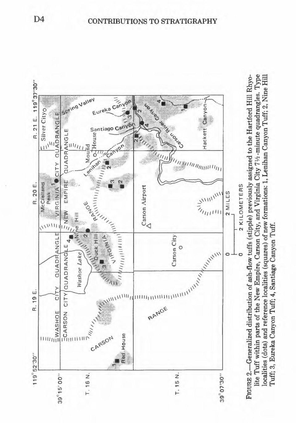
5 CONTENTS Page Abstract Dl Introduction 1 Acknowledgments 5 Ash-flow stratigraphy in the Carson City-Silver City area 7 Mickey Pass Tuff 7 Lenihan Canyon Tuff 8 Nine Hill Tuff 11 Eureka Canyon Tuff 14 Dacitetuff 16 Rhyolite tuff and augite rhyodacite tuff 16 Santiago Canyon Tuff 17 References cited ^ 19 ILLUSTRATIONS Page FIGURE 1. Sketch map showing generalized distribution of 34- to 17-m.y.-old ash-flow tuffs assigned to the Hartford Hill Rhyolite Tuff D2 2. Sketch map showing generalized distribution of ash-flow tuffs previously assigned to the Hartford Hill Rhyolite Tuff within parts of the New Empire, Carson City, and Virginia City 7 Vi -minute quadrangles 4 3. Chart showing summary of stratigraphic nomenclature of tuffs in the Carson City-Silver City area 5 4. Stratigraphic correlation chart of ash-flow tuffs in the Carson City and New Empire 7 Vz -minute quadrangles 6 5. Generalized geologic map showing the distribution of the Lenihan Canyon Tuff in its type locality 9 6. Generalized geologic map showing the distribution of the Nine Hill Tuff in its type locality Generalized geologic map showing the distribution of Eureka Canyon Tuff and Santiago Canyon Tuff in their type localities _ 15 m

6

7 CONTRIBUTIONS TO STRATIGRAPHY ABANDONMENT OF THE NAME HARTFORD HILL RHYOLITE TUFF AND ADOPTION OF NEW FORMATION NAMES FOR MIDDLE TERTIARY ASH-FLOW TUFFS IN THE CARSON CITY-SILVER CITY AREA, NEVADA By EDWARD C. BINGLERI ABSTRACT The formation name Hartford Hill Rhyolite, first applied to exposures of welded tuff underlying Hartford Hill near Silver City, Nev., and subsequently revised to the Hartford Hill Rhyolite Tuff, has traditionally been applied to all silicic tuffs in western Nevada that form the base of the Tertiary section and underlie andesite flows and breccias of the Alta and Kate Peak Formations. Recent mapping in the Carson City-Silver City area reveals that rocks included within the Hartford Hill Rhyolite Tuff make up a diverse sequence, locally more than 800 m thick, of welded ash-flow tuffs ranging in age from 22 to 28 m.y., erupted from widely separated sources. Several of these tuffs have recently been recognized and named in the Yerington area and mapped in the Gabbs Valley and Gillis Ranges. Four new formations are recognized and named in the Carson City-Silver City area. As it is now clear that rocks previously assigned to the Hartford Hill include genetically and compositionally unrelated ash-flow tuff cooling units of formation rank, no useful purpose is served by continuing the use of this formation name, and it is herein abandoned. Ash-flow units mapped in the Carson City-Silver City area and described in this report are, from oldest to youngest: Mickey Pass Tuff; Lenihan Canyon Tuff (new name); Nine Hill Tuff (new name); Eureka Canyon Tuff (new name); a thin erosional remnant of biotite dacite crystal tuff tentatively correlated with a similar tuff in the northern Gillis Range; thin and discontinuous erosional remnants of rhyolite and rhyodacite tuff correlated with similar rocks in the Gillis and Gabbs Valley Ranges; and the Santiage Canyon Tuff (new name). INTRODUCTION For the past 20 years, it has been common stratigraphic practice to assign all Tertiary silicic ash-flow tuffs (fig. 1) that underlie andesite flows and breccias of the Alta and Kate Peak Formations of central- 'Nevada Bureau of Mines and Geology, University of Nevada, Reno, Nev Dl

8 D2 CONTRIBUTIONS TO STRATIGRAPHY EXPLANATION 40 C Canyon - Hartford Hill Rhyolite Tuff as mapped by Moore (1969), Bonham (1969), and others Type locality of Hartford Hill Rhyolite Tuff Reno Pah Rah «SP--,, t Range ^i^xpainted Rock,,, NEVADA 39.**,\<* A<*' CARSON..' O CITY ;- Virginia City * QUAD- 5 o.' ' RANGMt-_v Silver'City, 3 "N i *#&Q,> \ Ma-ajiws *& > -,.'" :'NEV\r X : EMPIRE % :QUAD- E RANGLE Terrill /Mountains./". Q, 10 MILES 10 KILOMETERS FIGURE 1. Generalized distribution of 34 to 27-m.y.-old ash-flow tuffs (modified from Stewart and Carlson, 1976) assigned to the Hartford Hill Rhyolite Tuff. Tuffs in the Gillis and Gabbs Valley Ranges are laterally equivalent to tuffs in the Wassuk and Singatse Ranges assigned to the Hartford Hill by Moore (1969). western Nevada to the Hartford Hill Rhyolite Tuff. Gianella (1936, p. 47) originally coined the name Hartford Hill Rhyolite for exposures of rhyolite in the Silver City mining district. He did not designate a type section but reported that the rhyolite underlies Hartford Hill, a small knoll about 1.6 km northwest of Silver City. Thompson
 assigned to the Hartford Hill Rhyolite Tuff.")
9 NEW FORMATION NAMES FOR ASH-FLOW TUFFS, NEVADA (1956, p. 50), in mapping the geology of the Virginia City 15-minute quadrangle, designated the hill as the type locality. Recognizing that nearly all of the Hartford Hill Rhyolite was of pyroclastic origin, he modified the formation name to Hartford Hill Rhyolite Tuff to better represent the lithologic types present. Bonham (1969) and Moore (1969) included in the Hartford Hill thick isolated sections of tuff as far north as Pyramid Lake and as far east as the Terrill Mountains (fig. 1). Recent mapping of pyroclastic rocks in west-central Nevada previously assigned to the Hartford Hill employs the principles and techniques of ash-flow stratigraphy based on the classic studies of Smith (1960a, b) and Ross and Smith (1961). Bingler (1973) described four compositionally and texturally distinct ash-flow tuffs in the Wassuk Range that make up the section of rock assigned by Moore (1969) to the Hartford Hill Rhyolite Tuff. Wallace (1975) recognized siz ash-flow tuff cooling units ranging in age from 28 to 22 m.y. at Rainbow Canyon southwest of Pyramid Lake in tuffs previously mapped as Hartford Hill Rhyolite by Bonham (1969). A thick section of ash-flow tuffs in the Singatse Range, earlier assigned to the Hartford Hill by Moore (1969), was subdivided by Proffett and Proffett (1976) into four compositionally and texturally distinct tuffs ranging in age from 28 to 24 m.y.: the Mickey Pass Tuff, the Singatse Tuff, the Bluestone Mine Tuff, and the tuff and breccia of Gallagher Pass. Ekren and others (E. B. Ekren, written commun., 1976), in mapping five 15-minute quadrangles in the Gillis and Gabbs Valley Ranges, identified a large number of ash-flow cooling units in addition to the Mickey Pass and the Singatse Tuffs. Direct field evidence for cauldron sources related to any one of the cooling units described is rare. The areal distribution of the principal ash-flow sheets and the distribution of locally thick stratigraphic sections suggest that (1) the Mickey Pass and Singatse Tuffs were erupted from a source region in the Singatse Range-Wassuk Range area and (2) several of the ash-flow tuff sheets mapped by Ekren and others (E. B. Ekren, written commun., 1976) occupy a broad regional depression or source region centered on the southern Gillis-northern Gabbs Valley Range area. Recently completed mapping by Bingler (1978) and Trexler (1978) near the type locality of the Hartford Hill Rhyolite Tuff reveals that rocks previously assigned to this formation consist of a thick section of Mickey Pass Tuff, thin distal edges of ash-flow tuffs mapped in the Gillis and Gabbs Valley Ranges, and four ash-flows of formation rank named in this report (figs. 2, 3, and 4). Three of the four newly named formations are related to cauldron sources in the Carson City-Silver City area; they range in age from 26 to 22 m.y. D3

10 D4 CONTRIBUTIONS TO STRATIGRAPHY 0> ^
11 NEW FORMATION NAMES FOR ASH-FLOW TUFFS, NEVADA D5 Gianella (1936) Thompson (1956) This report Hartford Hill Rhyolite Santiago Canyon Tuff 1 Unnamed tuffs Eureka Canyon Tuff 1 Hartford Hill Rhyolite Tuff Nine Hill Tuff H atus Lenihan-Canyon Tuff Mickey Pass Tuff New names used in this report FIGURE 3. Summary of stratigraphic nomenclature of tuffs in the Carson City- Silver City area. and are interlayered with ash-flow sheets originating in the Singatse Range-Wassuk Range and Gillis Range-Gabbs Valley regions. Since the Hartford Hill Rhyolite Tuff as now employed includes a diverse sequence of genetically and compositionally unrelated cooling units of ash-flow tuff of middle Tertiary age from widely separated source regions, and since recent mapping has demonstrated that many of its individual cooling units are also of formational rank, no useful purpose is served by continuing its use, and the formation name Hartford Hill Rhyolite Tuff is herein abandoned. ACKNOWLEDGMENTS Ash-flow tuffs in the Carson City-Silver City area were mapped as part of a more comprehensive program of geologic mapping for earthquake hazard reduction supported in part by U.S. Geological Survey Grant G-248. H. F. Bonham, Jr., and L. J. Garside, of the Nevada Bureau of Mines and Geology, and J. H. Stewart, M. L. Silberman, and D. H. Whitebread, of the U.S. Geological Survey, made helpful suggestions on the manuscript. I wish to thank H. F. Bonham, Jr., for stimulating discussions on the Cenozoic ashflow stratigraphy of western Nevada.

12 Nine Hill Lenihan Canyon East Hackett Canyon FIGURE 4. Stratigraphic correlation chart of ash-flow tuffs in the Carson City and New Empire 7 1/2 -minute quadrangles. See figure 2 for locations. 8 H 53

13 NEW FORMATION NAMES FOR ASH-FLOW TUFFS, NEVADA ASH-FLOW STRATIGRAPHY IN THE CARSON CITY-SILVER CITY AREA D7 During the course of geologic mapping in the New Empire and Carson City 7 V2-minute quadrangles (figs. 1, 2), the sequence of silicic ash-flow cooling units heretofore assigned to the Hartford Hill Rhyolite Tuff (fig. 2) was divided into eight map units distinguished on the basis of composition, phenocryst ratios and abundance, characteristic accessory mineral species, and the stratigraphic parameters of age and bounding disconformities (Bingler, 1978; Trexler, 1978). These eight tuff units, erupted from 28 to 22.5 m.y. ago, are, from oldest to youngest: Mickey Pass Tuff (Proffett and Proffett, 1976), Lenihan Canyon Tuff, Nine Hill Tuff, Eureka Canyon Tuff, an unnamed biotite dacite tuff also recognized in the Gillis Range (R. F. Hardyman, oral commun., 1976), an unnamed rhyolite tuff and an augite rhyodacite tuff also mapped in the Gillis and Gabbs Valley Ranges (E. B. Ekren, written commun., 1976), and the Santiago Canyon Tuff. MICKEY PASS TUFF The Mickey Pass Tuff, one of the oldest and most extensive of the widespread ash-flow tuff sheets in western Nevada, was named by Proffett and Proffett (1976, p. 8) for exposures just north of Mickey Pass in the Singatse Range near Yerington, Nev. At the type locality, it includes two members, the Guild Mine and the overlying Weed Heights, and minor amounts of weakly welded tuff and tuffaceous sediment. The Guild Mine Member is a compound cooling unit of as much as 900 m of dense, hard, devitrified, brown to reddish-brown crystal-vitric rhyodacite to rhyolite tuff, strongly to moderately welded throughout. Vapor-phase crystallization is prominent only near the top. The base of the member is commonly marked by black crystal-rich vitrophyre as much as 30 m thick. The Weed Heights Member is a simple cooling unit formed of as much as 200 m of moderately welded crystal-rich quartz latite to rhyolite tuff. In the Carson City-Silver City area, the Mickey Pass Tuff consists entirely of rock very similar to tuff assigned by Proffett and Proffett (1976, p. 10) to their Guild Mine Member. The formation is a simple cooling unit generally with a few meters of densely welded black
. These eight tuff units, erupted from 28 to 22.5 m.y.")
14 D8 CONTRIBUTIONS TO STRATIGRAPHY crystal-rich vitrophyre at the base that grades rapidly upward into compact tan to red-brown vitric crystal tuff composed of about 10 percent sanidine, 10 percent plagioclase, 5 percent quartz, and a few percent biotite set in a strongly welded matrix of fine ash and sparse pumice. The rock grades upward into weakly to moderately welded lavender tuff that is more crystal rich (30-40 percent) and contains distinctive somewhat rounded bleached white blotches 2 to 3 cm in diameter produced by weak but pervasive vapor-phase alteration in the upper third of the formation. White pumice lapilli increase upward, making up about 10 percent of the rock near the top. Near the top of the formation, quartz phenocrysts that constitute about 15 percent of the total rock are distinctly vermicular and have prominent graphic outlines. Just southwest of Mound House (fig. 2), approximately 150 m of welded ash-flow tuff typical of the lower part of the Mickey Pass Tuff is disconformably overlain by younger tuff; presumably the crystal-rich lavender blotchy upper part of the formation is eroded. The thick section of Mickey Pass Tuff (120 m) exposed at the head of Lenihan Canyon (figs. 2, 5) differs somewhat from the formation as exposed elsewhere in the mapped area in that weak vapor-phase crystallization has affected the tuff nearly to its base and that the upper part of the formation is marked by a very prominent vaporphase zone that is strongly oxidized, is orange red from disseminated hematite, and forms bold somewhat cavernous-weathering outcrops. Above the top of the vapor-phase zone, the tuff is white to pale greenish white, weakly welded to nonwelded, and strongly zeolitized. The Mickey Pass Tuff occurs widely in the New Empire quadrangle and in the northeastern part of the adjacent Carson City quadrangle, where it is exposed as isolated patches resting on pre- Tertiary basement rocks. It is best exposed in sec. 6, T. 15 N., R. 21 E.; sec. 1, T. 15 N., R. 20 E.; sec. 36, T. 16 N., R. 20 E.; and sees. 14 and 23 in T. 16 N., R. 20 E. The exposed thickness is highly variable owing to its mode of deposition; the ash flows first filled valleys and later buried the surrounding hills of a mature topography cut on faulted and deeply eroded pre-tertiary rocks. Maximum exposed thickness of the member is approximately 300 m. Concordant Oligocene potassium-argon ages of 28.0 ± 0.8 m.y. on biotite and 28.6 ± 0.9 m.y. on plagioclase are reported for vitrophyre at the base of the Mickey Pass in the Carson River canyon (M. L. Silberman, written commun., 1976).

15 NEW FORMATION NAMES FOR ASH-FLOW TUFFS, NEVADA D9 R. 20 E ' EXPLANATION Tertiary tuffs, undivided Lehnihan Canyon Tuff Mickey Pass Tuff Unconformity Pre-Tertiary rocks Contact Fault Type section 2000 FEET METERS CONTOUR INTERVAL 200 FEET FIGURE 5. Generalized geologic map showing the distribution of the Lenihan Canyon Tuff in its type locality. Base from U.S. Geological Survey Virginia City and New Empire 7 Vi-minute quadrangles. LENIHAN CANYON TUFF The Mickey Pass Tuff is disconformably overlain by as much as 300 m of pale-lavender-brown fine-grained hornblende-biotite quartz latite vitric-crystal tuff, here named the Lenihan Canyon Tuff for its type locality exposures (figs. 2, 5) along the east side of

16 D10 CONTRIBUTIONS TO STRATIGRAPHY Lenihan Canyon and in the ridge south of McClelland Peak (sees. 14 and 15, T. 16 N., R. 20 E.). The type section is located in the NEW NEW sec. 14, T. 16 N., R. 20 E., approximately one-half mile northeast of Lenihan Canyon (fig. 5). Two reference localities are designated. The principal reference locality is along the west side of Hackett Canyon in sees. 16 and 17, T. 15 N., R. 21 E., the second at Red House in sec. 32, T. 16 N., R. 19 E. (fig. 2). The Lenihan Canyon Tuff everywhere rests on the Mickey Pass Tuff except at Red House, in the Carson Range, where it rests unconformably on Cretaceous granodiorite. Where exposed in Hackett Canyon and near McClelland Peak, the tuff overlies the weakly welded to nonwelded top of the Mickey Pass; there appears to have been little erosion between the eruption of the last ash flows of the Mickey Pass and the first ash flows of the Lenihan Canyon. In the Hackett Canyon exposures, a few small pebbles of pre-tertiary rocks in the float mark the basal disconformity. The Lenihan Canyon Tuff is a simple cooling unit of moderately to strongly welded hornblende biotite quartz latite. At Hackett Canyon and Red House, the basal few meters consist of white to graywhite weakly welded vitric-crystal tuff that grades rapidly upward into gray to gray-black densely welded phenocryst-rich vitrophyre, generally less than 5 m thick. The bulk of the formation is devitrified pale-lavender to purplish-tan fine-grained crystal-vitric tuff. Phenocrysts make up about 25 percent of the rock: about 5 percent are quartz, 3 percent sanidine, 12 percent plagioclase (Ca-oligoclase), 3 percent biotite, 2 percent hornblende, and a trace of opaque oxides. Pumice and lithic fragments are sparse to very rare. Features characteristic of this tuff are (1) fresh black biotite flakes 1-3 mm in diameter that are well alined in the foliation plane, imparting a prominent speckled appearance to fracture surfaces parallel to the foliation; (2) abundant small (average 0.5 mm) plagioclase phenocrysts, inconspicuous in hand specimen; (3) sparse distinctively large quartz (slightly vermicular and rounded) and subhedral sanidine phenocrysts about 0.5 cm in diameter; and (4) hornblende phenocrysts. Despite these distinguishing features, it may be difficult to distinguish Lenihan Canyon Tuff from isolated outcrops of the devitrified lower part of the Mickey Pass Tuff. In thin section, however, the Mickey Pass (except for the basal vitrophyre) is not seen to contain the fine-grained plagioclase phenocrysts ubiquitous in the Lenihan Canyon, nor does it contain hornblende phenocrysts. And in much of the Mickey Pass Tuff, quartz tends to occur as subhedral bipyramids that contain vermicular inclusions of glass. Biotite and sanidine separated from samples of the Lenihan Canyon Tuff south of McClelland Peak and radiometrically dated by

17 NEW FORMATION NAMES FOR ASH-FLOW TUFFS, NEVADA D11 potassium-argon techniques yielded slightly discordant Oligocene dates of 26.7 ± 0.8 m.y. on biotite and 25.1 ± 0.8 m.y. on sanidine (M. L. Silberman, written commun., 1976). The source area of the Lenihan Canyon Tuff is not known with certainty, but exposures of this tuff at Red House may be very near a cauldron source. Here a dike-shaped mass of black vitrophyre with vertical foliation trends approximately east-west and appears to intrude nearly flat-lying devitrified prominently zoned Lenihan Canyon Tuff. Along the south contact of the dike-shaped mass, devitrified Lenihan Canyon Tuff is brecciated and oxidized to reddish brown; these textures disappear a few meters away from the contact. Owing to extensive colluvial cover, this apparent intrusive relation could not be traced in the field except where the contact is exposed along an aqueduct. NINE HILL TUFF The Nine Hill Tuff is here named for a distinctive and lithologically diverse compound cooling unit of pumiceous, in part densely welded and stretched, vitric tuff and tuff-breccia exposed in and around Nine Hill in sees. 20,21, and 29, T. 16 N., R. 20 E. (figs. 2,6). The type section (fig. 6) is in NEV4 sec. 29, T. 16 N., R. 20 E. Other reference localities (fig. 2) are designated near the mouth of Santiago Canyon (NEV4 sec. 6, T. 15 N., R. 21 E.) (the principal reference locality), in Eureka Canyon (SWV4 sec. 33, T. 16 N., R. 21 E.), in the hills 1 mile north-northeast of the Carson Airport (SWV4 sec. 34, T. 16 N., R. 20 E.), and in an unnamed south-draining canyon in sees. 26 and 35, T. 16 N., R. 20 E. At the type locality, the Nine Hill Tuff unconformajbly overlies pre-tertiary basement rocks and scattered thin erosional remnants of Mickey Pass Tuff and is disconformably overlain by Eureka Canyon Tuff and late Tertiary basaltic andesite flows. In the type section, the Nine Hill unconformably overlies Mesozoic granodiorite. Here it is nearly 250 m thick; its lower 130 m is densely welded and lineated, whereas its top is deeply eroded. Throughout much of the New Empire and Carson City quadrangles (fig. 2), the base of the Nine Hill Tuff includes several meters of cobble to boulder gravel made up of rounded clasts of older tuffs and basement rocks. At the reference locality in the mouth of Eureka Canyon, the base of the Nine Hill contains large boulders (average diameter 1-2 m; maximum diameter 5m) of Singatse(?) Tuff, Lenihan Canyon Tuff, and Triassic meta-andesite in a nonwelded matrix of vitric tuff-breccia. The Nine Hill Tuff includes four principal rock types distinguished by pumice content, degree of welding and secondary flowage, and phenocryst content. At the type locality, in the hills

18 D12 CONTRIBUTIONS TO STRATIGRAPHY R. 20 E ' T. 16 N ' 2000 FEET METERS CONTOUR INTERVAL 200 FEET EXPLANATION Tertiary volcanic rocks, undivided Contact Fault Type section Pre-Tertiary rocks FIGURE 6. Generalized geologic map showing the distribution of the Nine Hill Tuff in its type locality. Base from U.S. Geological Survey Carson City and New Empire 7 Vz-minute quadrangles. northeast of the Carson Airport, and in the Santiago Canyon drainage, the Nine Hill is made up of a densely welded and prominently eutaxitic pumice-rich lower part a few to more than 400 m thick and a pumice-poor weakly welded to nonwelded upper part a few tens to

19 NEW FORMATION NAMES FOR ASH-FLOW TUFFS, NEVADA D13 several hundred meters thick. The contact between these two principal rock types in the Nine Hill Tuff is everwhere gradational. The lower part of the Nine Hill consists of devitrified densely welded to stretched (length-to-thickness ratio of pumice lapilli greater than 20:1) pale-orange-red to pale-green to reddish-purple pumiceous vitric tuff. This rock typically is about 3-4 percent phenocrysts (sanidine:plagioclase:quartz approximately 4:2:1 plus a trace of biotite), percent strongly flattened to stretched pumice lapilli generally 2-3 cm in longest dimension, and 2-5 percent small felsitic lithic fragments, all set in a matrix of devitrified fine-grained shards and ash. The upper part of the Nine Hill Tuff is pale-brown to purplish-brown vitric tuff containing less than 5 percent undeformed to slightly flattened pumice lapilli, a trace of very small felsitic lithic fragments, and about 5 percent small equant phenocrysts of sanidine, plagioclase, and quartz set in a fine-grained devitrified matrix of undeformed glass shards and submicroscopic ash. Where exposed 2.4 km west of Mound House, densely welded and lineated tuff typical of the lower part of the Nine Hill grades into fluidal crystal-rich vitric tuff. These fluidal rocks contain less than 2 percent pumice and somewhat more than 10 percent phenocrysts of sanidine (9 percent) and quartz (2 percent). The rock appears flow banded in hand specimen and contains numerous wispy lens-shaped vugs where pockets of vapor-phase crystallization products have disaggregated and weathered from the rock. Similar fluidal vitric tuff is not exposed elsewhere in the mapped area, but I have seen identical tuff in Warm Springs Valley south of the Virginia Range and at Painted Rock (fig. 1). In both these localities, the fluidal tuff lies on densely welded and lineated tuff in the lower part of the Nine Hill Tuff with no indication of a cooling break. In Eureka Canyon, the Nine Hill Tuff consists entirely of pale-pinkish-brown nonwelded pumiceous vitric tuff that disconformably overlies the Lenihan Canyon Tuff in Hackett Canyon or the Mickey Pass Tuff in Eureka Canyon and is separated from the overlying Eureka Canyon Tuff by a disconformity. The tuff in these two localities contains about 8 percent pumice lapilli ranging in maximum diameter from less than 1 to more than 4 cm; 2-5 percent small phenocrysts of plagioclase, sanidine, and quartz (2:2:1) plus a trace of biotite; a few percent of angular felsitic lithic fragments about 1 cm or less in diameter; and fine-to medium-grained shard-rich ash. Locally within the Nine Hill Tuff, very densely welded and stretched tuff forms near-vertical dikes and pluglike masses that intrude brecciated and in part hydrothermally altered vitric tuff typical of the upper part of the unit. The dikelike masses are surrounded by an envelope of brecciated tuff a few meters to 10 m thick. Discon-
, 10-15 percent strongly flattened to stretched pumice lapilli generally")
20 D14 CONTRIBUTIONS TO STRATIGRAPHY tinuous patches of bleached and hydrothermally altered breccia within the envelope were formed by upward-streaming volatiles that accompanied the brecciation. These features strongly suggest that the plugs and dikes of tuff fill pyroclastic vents developed in the Nine Hill as it accumulated. It is possible that the densely welded and very hot lower part of the unit locally flowed and was diapirically forced upward through a thick intracaldera accumulation of vitric tuff. These unusual intrusive phases and the locally very thick accumulation of densely welded tuff suggest that much of the Nine Hill in the study area is in or near its cauldron source. The Nine Hill Tuff is an areally extensive ash-flow sheet. Known equivalents occur in Warm Springs Valley as noted, in the Gillis Range (R. F. Hardyman, oral commun., 1976), and in the Singatse and Wassuk Ranges. The Nine Hill intertongues with the tuff of Gabbs Valley (E. B. Ekren, written commun., 1976) and is younger than the Lenihan Canyon Tuff. These stratigraphic relations indicate that the Nine Hill Tuff was erupted during the Oligocene about 25 m.y. ago. EUREKA CANYON TUFF The Nine Hill Tuff is overlain disconformably by a compound cooling unit as much as 150 m thick of white to pale-gray, lavender, and tan rhyolite vitric tuff here named the Eureka Canyon Tuff for exposures at its type locality in sees 32 and 33, T. 16 N., R. 21 E. (figs. 2, 7). The type section (fig. 7) is at the common boundary between sees. 32 and 33, T. 16 N., R. 21 E. Reference sections (fig. 2) are designated 2.25 km northeast of the Carson Airport in NEV4 NWV4 sec. 34, T. 16 N., R. 20 E., and at Duck Hill in sec. 30, T. 16 N., R. 20 E. In Eureka Canyon, the formation is about 130 m thick and displays a distinct cooling zonation. Pale-green zeolitized poorly welded to nonwelded tuff a few meters thick grades upward into moderately welded gray vitrophyre with a maximum thickness of about 5 meters. Above the vitrophyre, the tuff is devitrified and displays weak vapor-phase alteration. Above the vapor-phase zone, the rock is a gray-white glassy shard tuff 5-10 m thick to the top of the cooling unit. Elsewhere in the study area, most of the Eureka Canyon is white to pale-yellowish-white bleached devitrified weakly welded tuff. North of the airport and at Duck Hill, the Eureka Canyon includes several thin gray zones (1-3 m) of glassy vitrophyre, and it is probable that the boundary where these glassy zones overlie weak vapor-phase rock represents a partial cooling break. The Eureka Canyon Tuff is very uniform in primary texture and composition. Most of the tuff contains about 3-8 percent phenocrysts set in a matrix of partially welded to nonwelded glass shards

21 NEW FORMATION NAMES FOR ASH-FLOW TUFFS, NEVADA D15 R. 21 E '30" 2000 FEET Quaternary alluvium and Tertiary volcanic rocks METERS CONTOUR INTERVAL 200 FEET EXPLANATION Contact Fault Santiago Canyon Tuff Type section Eureka Canyon Tuff Unconformity Tertiary and pre-tertiary rocks FIGURE 7. Generalized geologic map showing the distribution of Eureka Canyon Tuff and Santiago Canyon Tuff in their type localities. Base from U.S. Geological Survey New Empire 7 Vi -minute quadrangle. (0.2 mm) and about 5-10 percent lenticular weakly compacted white pumice fragments. Phenocrysts comprise percent quartz, percent sanidine, a few percent to 10 percent plagioclase, and a few small ragged flakes of biotite per thin section. The Eureka Canyon Tuff correlates with the upper part of the Bluestone Mine Tuff of Proffett and Proffett (1976) and with one of the thin cooling units in the tuff of Gabbs Valley (E. B. Ekren, writ-
22 D16 CONTRIBUTIONS TO STRATIGRAPHY ten commun., 1976), where potassium-argon determinations on two sanidine separates yielded Oligocene ages of 25.0 ± 1.0 and 26.1 ± 0.8 m.y. In the Carson City-Silver City area, the Eureka Canyon is locally separated from the underlying Nine Hill Tuff by beds of bouldery gravel a few meters thick that contain rounded cobble- to boulder-size clasts of Mickey Pass Tuff, Nine Hill Tuff, Lenihan Canyon Tuff, and basement rocks. The occurrence of this gravel indicates that considerable erosion and alluviation took place after the Nine Hill eruptive episode and before emplacement of the first ash flows of the Eureka Canyon Tuff. DACITE TUFF Southwest of McClelland Peak (fig. 2) in sec. 15, T. 16 N., R. 20 E., the Lenihan Canyon Tuff is disconformably overlain by a thin erosional remnant (10 m) of biotite-plagioclase crystal vitric dacite tuff reported by Hardyman to correlate with one of the tuffs of Gabbs Valley exposed in the northern Gillis Range (R. F. Hardyman, oral commun., 1976); the correlation is made principally by the distinctive petrography of the unit and the position of the tuff in the stratigraphic section. The tuff rests in part on the Lenihan Canyon Tuff and in part on intraformational boulder-to-cobble gravel that fills a channel cut nearly through the Lenihan Canyon Tuff to just above the top of the Mickey Pass Tuff. Clasts in the gravel include boulders of Lenihan Canyon Tuff, Nine Hill Tuff, and Eureka Canyon Tuff. The dacite tuff is a devitrified remnant of a moderately welded simple cooling unit. Pumice fragments are very small and sparse; lithic fragments are rare. In thin section the phenocryst fraction includes 30 percent fresh broken phenocrysts of zoned plagioclase (andesine) ranging in size from less than 0.1 mm to 3 mm, 5 percent redbrown biotite, 4 percent magnetite, and a trace of quartz. The rock generally is a distinct reddish brown due to disseminated finegrained hematite in the matrix. RHYOLITE TUFF AND AUGITE RHYODACITE TUFF Rhyolite tuff and augite rhyodacite tuff are exposed in the Hackett Canyon-Carson River canyon area, where they overlie the Eureka Canyon Tuff and are overlain by the Santiago Canyon Tuff. Both units are thin distal edges of much thicker and more complex eruptive sequences exposed in the Singatse Range (Proffett and Proffett, 1976, p. 21), Wassuk Range (Bingler, 1973, p. 12), and east of Walker Lake in the Gillis Range (R. F. Hardyman, oral commun., 1976).
23 NEW FORMATION NAMES FOR ASH-FLOW TUFFS, NEVADA D17 Along the west side of Eureka Canyon in sec. 32, T. 16 N., R. 21 E., the Eureka Canyon Tuff is disconformably overlain by gray-white to yellowish-gray sparsely porphyritic pumiceous fine-grained glassy rhyolite vitric-crystal tuff as much as m thick. The tuff is weakly welded to nonwelded and is about percent undeformed shards and fine ash. Phenocrysts comprise 9 percent plagioclase, 7 percent quartz, 2 percent sanidine, 2 percent biotite, and traces of hornblende and anorthoclase. Most phenocrysts are fragments of larger cognate crystals, but ovoid and vermicular grains of quartz and anorthoclase as much as 1 cm in diameter are scattered throughout the tuff. The distinctive quartz grains greatly aid in identifying the rhyolite tuff in isolated outcrops. The rhyolite tuff is disconformably overlain by a very distinctive pale-greenish-gray augite-biotite-plagioclase pumice- and lithicrich crystal-lithic tuff of rhyodacitic composition. In Eureka Canyon this tuff fills a channel cut several tens of meters into the top of the underlying rhyolite tuff. At Hackett Canyon the tuff is disconformable on the Eureka Canyon Tuff, but there is little relief on the erosion surface, and no pebble beds mark the disconformity. The pyroxene-bearing tuff is distinctive in its mineralogy and clearly related to the thick succession of augite rhyodacite tuff, breccia, and lava flows in the Walker Lake area. The augite rhyodacite tuff is very thin north of the Carson River but reaches a maximum thickness of about 170 m in and east of Hackett Canyon (fig. 2) (sec. 16, T. 15 N., R. 21 E.). The tuff is uniform in texture and mineralogy and displays no distinct cooling zonation. The rock consists of about 5-10 percent cognate lithic fragments composed of pale-brownish-lavender augite rhyodacite lava, approximately 20 percent undeformed white pumice (average diameter cm), and percent medium-sized phenocrysts, all set in a matrix of fine-grained ash. The phenocrysts include about 30 percent plagioclase, 15 percent fresh black biotite, and 5 percent or less apple-green diopsidic augite. In many exposures the pyroxene is altered and weathered from the rock, leaving characteristic small cavities marking the former presence of the stubby pyroxene crystals. Radiometric dates obtained (E. B. Ekren and others, written commun., 1976) on biotite from augite rhyodacite tuff in the Gillis Range are 23.2 ± 0.8 m.y., and on plagioclase 21.6 ± 0.6 m.y. SANTIAGO CANYON TUFF The youngest ash-flow tuff in the Carson City-Silver City area is a simple cooling unit of sphene-bearing hornblende-biotite quartz latite crystal-vitric tuff here named the Santiago Canyon Tuff for its type-section exposures at the mouth of Santiago Canyon in NWV4
24 D18 CONTRIBUTIONS TO STRATIGRAPHY sec. 5, T. 15 N., R. 21 E. Reference localities are designated at Hackett Canyon (fig. 2) in sec. 9, T. 15 N., R. 21 E., and at the hill 1.5 km northwest of Nine Hill (fig. 2) in W Mz NE % sec. 20, T. 16 N., R. 20 E. The Santiago Canyon Tuff rests disconformably on older Tertiary ash flows and unconformably on Mesozoic basement rocks; it is more than 300 m thick south of the Carson River near Santiago Canyon and is unconformably overlain by flows and breccias of the Alta Formation (Bingler, 1977). The great thickness of this tuff, together with the simple and uniform cooling zonation, suggests that its source lies within or just east of the Santiago Canyon-Hackett Canyon area (fig. 2). The Santiago Canyon Tuff typically includes a basal few meters of gray-white weakly welded tuff that grades upward into gray glassy densely welded vitrophyre a few meters to about 10 m thick. Above the vitrophyre, the cooling unit is strongly welded and devitrified tuff exhibiting only weak and local vapor-phase effects. Outcrops are blocky, somewhat rounded, and gray to pale lavender or brownish gray. The tuff contains about 10 percent pumice lapilli, in general considerably flattened as a result of uniformly strong welding. The foliation defined by these flattened pumice fragments is weak and difficult to discern because the fragments are nearly the same color as the rock and only 1-2 cm long. In thin section, the rock contains slightly less than 10 percent quartz, 5-10 percent sanidine, about 20 percent plagioclase (Ca-oligoclase), and 5 percent each of hornblende and biotite. Euhedral prisms of sphene, commonly 5-10 grains per thin section, are present in fresh rock. This accessory mineral, not found in any of the other ash-flow tuffs described, is critical in distinguishing the Santiago Canyon from the older, but texturally and mineralogically similar, Singatse Tuff of Proffett and Proffett (1976). In the Spring Valley area (fig. 2), the Santiago Canyon Tuff is moderately to intensely propylitized and silicified. Much of the rock is bleached by acid leaching related to oxidation of disseminated pyrite that occurs in the tuff as part of regional alteration related to the Comstock Lode. Where the tuff is propylitically altered, the overall color of the rock is lavender or purple, and feldspar and pumice fragments are chalky white aggregates that stand out against the darker matrix; the pumice lapilli, in particular, become clearly visible as 1-2-cm rounded or nearly circular white blotches on foliation planes. The general appearance of these pumice lapilli is a diagnostic feature useful for recognizing the Santiago Canyon Tuff in propylitized areas. Where the tuff is bleached and (or) silicified, it weathers pale yellowish tan to orange brown and is very light tan to white on fresh surfaces. Feldspar alters to chalky white remnants that are difficult to distinguish from the matrix; only the quartz phenocrysts (slightly
25 NEW FORMATION NAMES FOR ASH-FLOW TUFFS, NEVADA D19 vermicular and equant) help distinguish the Santiago Canyon Tuff from other older tuffs. The Santiago Canyon Tuff is of latest Oligocene or earliest Miocene age. Sanidine and biotite from vitrophyre near the base of the tuff yielded potassium-argon dates of 20.5 and 21.8 m.y., respectively (determination by Geochron Laboratories determination; Nevada Bureau of Mines and Geology sample AD 49). Whitebread (1976, table 1) reports a potassium-argon date of 22.7 m.y. on biotite from a tuff sample (Hartford Hill Rhyolite Tuff) apparently collected from rock here included in the Santiago Canyon Tuff. Sphene-bearing ash-flow tuff similar to the Santiago Canyon Tuff is recognized by E. B. Ekren (written commun., 1976) as underlying Copper Mountain in the Gabbs Valley area and by J. M. Proffett, Jr. (oral commun., 1976) as cropping out in the Terrill Mountains north of Schurz, Nev. Reconnaissance mapping by Bingler (unpub. mapping, 1976) at Hartford Hill, the type locality of the Hartford Hill Rhyolite Tuff, revealed that all of the rock assigned to the Hartford Hill Rhyolite by Gianella (1936) is now part of the Santiago Canyon Tuff. REFERENCES CITED Bingler, E. C., 1973, Oligocene welded tuff sequence in northern Wassuk Range, central-western Nevada: Geol. Soc. America Abs. with Programs v. 5, no. 1, p , Geologic map of the New Empire IVi' quadrangle: Nevada Bur. Mines and Geology Map 59. Bonham, H. F., 1969, Geology and mineral deposits of Washoe and Storey Counties: Nevada Bur. Mines Bull. 70,140 p. Gianella, V. P., 1936, Geology of the Silver City district and the southern portion of the Comstock Lode, Nevada: Nevada Univ. Bull., v. 30, no. 9,105 p. Moore, J. G., 1969, Geology and mineral resources of Lyon, Douglas, and Ormsby Counties, Nevada: Nevada Bur. Mines Bull. 75, 45 p. Proffett, J. M., Jr., and Proffett, Beth, 1976, Stratigraphy of the Tertiary ash-flow tuffs in the Yerington District, Nevada: Nevada Bur. Mines and Geology Rept. 27, 28 p. Ross, C. S., and Smith, R. L., 1961, Ash-flow tuffs their origin, geologic relations, and identification: U.S. Geol. Survey Prof. Paper 366, 81 p. Smith, R. L., 1960a, Zones and zonal variations in welded ash-flows: U.S. Geol. Survey Prof. Paper 354-F, p b, Ash-flows: Geol. Soc. America Bull, v. 71, p Stewart, J. H., and Carlson, J. E., 1976, Cenozoic rocks of Nevada: Nevada Bur. Mines and Geology Map 52. Thompson, G. A., 1956, Geology of the Virginia City quadrangle, Nevada: U.S. Geol. Survey Bull C, p Trexler, D. T., 1978, Geology of the Carson City 7 Vz' quadrangle: Nevada Bur. Mines and Geology Environmental Folio, Carson City area [in press]. Wallace, A. B., 1975, Geology and mineral deposits of the Pyramid district, southern Washoe County, Nevada: Nevada Univ., Reno, Ph. D. thesis, 162 p. Whitebread, D. H., 1976, Alteration and geochemistry of Tertiary volcanic rocks in parts of the Virginia City quadrangle, Nevada: U.S. Geol. Survey Prof. Paper 936, 43 p. -iv U.S. GOVERNMENT PRINTING OFFICE : /38
26
27
28
Earth Materials: Intro to rocks & Igneous rocks. The three major categories of rocks Fig 3.1 Understanding Earth
 Earth Materials: 1 The three major categories of rocks Fig 3.1 Understanding Earth 2 Intro to rocks & Igneous rocks Three main categories of rocks: Igneous Sedimentary Metamorphic The most common minerals
Amygdaloidal texture. Kimberlite. UNC sample. H-64 Rock type. amygdaloidal basalt Locality. unknown
 Amygdaloidal texture H-64 amygdaloidal basalt unknown The oval feature in this photomicrograph is an amygdule: a formerly open vesicle which has been filled with a secondary mineral(s) precipitated from
Igneous Rocks. Geology 200 Geology for Environmental Scientists
 Igneous Rocks Geology 200 Geology for Environmental Scientists Magma Compositions Ultramafic - composition of mantle Mafic - composition of basalt, e.g. oceanic crust. 900-1200 o C, 50% SiO 2 Intermediate
ES 104: Laboratory # 7 IGNEOUS ROCKS
 ES 104: Laboratory # 7 IGNEOUS ROCKS Introduction Igneous rocks form from the cooling and crystallization of molten rock material. This can occur below the surface of the earth forming intrusive rocks
Rocks & Minerals. 10. Which rock type is most likely to be monomineralic? 1) rock salt 3) basalt 2) rhyolite 4) conglomerate
 rock salt 3) basalt 2) rhyolite 4) conglomerate") 1. Of the Earth's more than 2,000 identified minerals, only a small number are commonly found in rocks. This fact indicates that most 1) minerals weather before they can be identified 2) minerals have
1. Of the Earth's more than 2,000 identified minerals, only a small number are commonly found in rocks. This fact indicates that most 1) minerals weather before they can be identified 2) minerals have
P1: Rock identification (I)
") P1: Rock identification (I) Examine the rocks specimens provided with the aid of these notes. All the rocks come from Ireland, as detailed on the attached map. Answer the short question on each specimen
P1: Rock identification (I) Examine the rocks specimens provided with the aid of these notes. All the rocks come from Ireland, as detailed on the attached map. Answer the short question on each specimen
** Rocks are aggregates of one or more minerals ** 3. Hardness: A measure of resistance to scratching. On the Mohs Scale, it ranges from 1 to 10.
 Lab 2: Mineral Lab notes. Minerals are inorganic, solid, naturally occurring substances that have a characteristic chemical compositions, distinctive physical properties, and crystalline structures. Chemical
89.215 - FORENSIC GEOLOGY GEOLOGIC TIME AND GEOLOGIC MAPS
 NAME 89.215 - FORENSIC GEOLOGY GEOLOGIC TIME AND GEOLOGIC MAPS I. Introduction There are two types of geologic time, relative and absolute. In the case of relative time geologic events are arranged in
Geologic History Review
 1. The climate that existed in an area during the early Paleozoic Era can best be determined by studying (1) the present climate of the area (2) recorded climate data of the area since 1700 (3) present
Sedimentary Rocks Practice Questions and Answers Revised September 2007
 Sedimentary Rocks Practice Questions and Answers Revised September 2007 1. Clastic sedimentary rocks are composed of and derived from pre-existing material. 2. What is physical weathering? 3. What is chemical
USING RELATIVE DATING AND UNCONFORMITIES TO DETERMINE SEQUENCES OF EVENTS
 EARTH AND ENVIRONMENT THROUGH TIME LABORATORY- EES 1005 LABORATORY THREE USING RELATIVE DATING AND UNCONFORMITIES TO DETERMINE SEQUENCES OF EVENTS Introduction In order to interpret Earth history from
How Did These Ocean Features and Continental Margins Form?
 298 10.14 INVESTIGATION How Did These Ocean Features and Continental Margins Form? The terrain below contains various features on the seafloor, as well as parts of three continents. Some general observations
Name: Rocks & Minerals 1 Mark Place, www.learnearthscience.com
 Name: Rocks & Minerals 1 KEY CONCEPT #1: What is a mineral? It is a, substance which has a What would be the opposite of this? KEY CONCEPT #2: What causes minerals to have different physical properties?
The Geology of the Marginal Way, Ogunquit, Maine
 Geologic Site of the Month February, 2002 The Geology of the Marginal Way, Ogunquit, Maine 43 14 23.88 N, 70 35 18.36 W Text by Arthur M. Hussey II, Bowdoin College and Robert G. Marvinney,, Department
Rocks & Minerals 1 Mark Place, www.learnearthscience.com
 Name: KEY Rocks & Minerals 1 KEY CONCEPT #1: What is a mineral? It is a naturally occurring, inorganic substance which has a definite chemical composition What would be the opposite of this? man-made,
Presents the. Rock Test Study Resource
 Presents the Rock Test Study Resource Created by Simone Markus Published by EngLinks 1 Preface This is a free resource provided by EngLinks for students in APSC 151. This presentation is a supplementary
Roadstone - which rock? Investigating the best rock type for the wearing course of roads
 Roadstone - which rock? Investigating the best rock type for the wearing course of roads Roads are made of various types of rock aggregate (crushed rock fragments). Quarries provide the aggregate used
1. Base your answer to the following question on on the photographs and news article below. Old Man s Loss Felt in New Hampshire
 UNIT 3 EXAM ROCKS AND MINERALS NAME: BLOCK: DATE: 1. Base your answer to the following question on on the photographs and news article below. Old Man s Loss Felt in New Hampshire FRANCONIA, N.H. Crowds
EARTH SCIENCE 110 INTRODUCTION to GEOLOGY MINERALS & ROCKS LABORATORY
 EARTH SCIENCE 110 INTRODUCTION to GEOLOGY DR. WOLTEMADE NAME: SECTION: MINERALS & ROCKS LABORATORY INTRODUCTION The identification of minerals and rocks is an integral part of understanding our physical
Igneous Geochemistry. What is magma? What is polymerization? Average compositions (% by weight) and liquidus temperatures of different magmas
 and liquidus temperatures of different magmas") 1 Igneous Geochemistry What is magma phases, compositions, properties Major igneous processes Making magma how and where Major-element variations Classification using a whole-rock analysis Fractional crystallization
1 Igneous Geochemistry What is magma phases, compositions, properties Major igneous processes Making magma how and where Major-element variations Classification using a whole-rock analysis Fractional crystallization
BOWEN'S REACTION SERIES
 BOWEN'S REACTION SERIES Purpose John J. Thomas Frequently, people cannot visualize the mineral associations that form the sequences of igneous rocks that you find in the earth's crust and what happens
MINERALS IN BATES LIMESTONE, LEWTSTON, MAINE* Llovn W. Frsnon, Bates College, Lewi.ston, Maine. INrnonucrton
 MINERALS IN BATES LIMESTONE, LEWTSTON, MAINE* Llovn W. Frsnon, Bates College, Lewi.ston, Maine. INrnonucrton Location.-The city of Lewiston is located in the southwestern part of Maine, in Androscoggin
7) A clastic sedimentary rock composed of rounded to subrounded gravel is called a A) coal. B) shale. C) breccia.
 A clastic sedimentary rock composed of rounded to subrounded gravel is called a A) coal. B) shale. C) breccia.") Please read chapters 10 and 5 CHAPTER 5 Sedimentary Rocks 1) Sedimentary rocks A) form by compaction and cementation of loose sediment. B) are widespread on the continents and ocean floor. C) are common
Please read chapters 10 and 5 CHAPTER 5 Sedimentary Rocks 1) Sedimentary rocks A) form by compaction and cementation of loose sediment. B) are widespread on the continents and ocean floor. C) are common
Rock Identification Lab
 Rock Identification Lab Name Mineral Hardness Objective: You will determine the relative hardness of common objects relative to the known hardness of index minerals. We will use fingernail, copper, glass,
Metamorphic rocks are rocks changed from one form to another by intense heat, intense pressure, and/or the action of hot fluids.
 Metamorphic Rocks, Processes, and Resources Metamorphic rocks are rocks changed from one form to another by intense heat, intense pressure, and/or the action of hot fluids. Protolith or parent rock is
CATACLYSMIC ERUPTIONS
 CATACLYSMIC ERUPTIONS The really big ones! This figure compares the size of some recent, well-known eruptions. Note how small the eruptions of Mount St. Helens and even Vesuvius are compared to Katmai,
Instructor: Ms. Terry J. Boroughs Geology 305 INTRODUCTION TO ROCKS AND THE ROCK CYCLE
 DATE DUE: Name: Instructor: Ms. Terry J. Boroughs Geology 305 INTRODUCTION TO ROCKS AND THE ROCK CYCLE Instructions: Read each question carefully before selecting the BEST answer Provide specific and detailed
principles of stratigraphy: deposition, succession, continuity and correlation
 Relative Age Dating Comparative Records of Time Nature of the rock record principles of stratigraphy: deposition, succession, continuity and correlation Stratigraphic tools biological succession of life:
Rocks and Minerals What is right under your feet?
 Rocks and Minerals What is right under your feet? Name: 1 Before you start What do you already know? What is the difference between a rock and a mineral? What are the three categories of rocks? 1. 2. 3.
Introduction to Structural Geology
 Introduction to Structural Geology Workbook 3 Geological Maps BGS Introduction to geological maps 4 1. Outcrop patterns on geological maps 7 2. Cross sections 16 3. Structure contours 22 cknowledgements
QUATERNARY DATING METHODS 1: RELATIVE DATING TECHNIQUES
 QUATERNARY DATING METHODS 1: RELATIVE DATING TECHNIQUES Objectives: In this lab we will examine relative dating methods used to date Quaternary glacial deposits. After this lab you should be able to: 1)
Characteristics of Sedimentary Rocks
 Characteristics of Sedimentary Rocks Deposited at the earth s surface by wind, water, glacier ice, or biochemical processes Typically deposited in strata (layers) under cool surface conditions. This is
All sediments have a source or provenance, a place or number of places of origin where they were produced.
 Sedimentary Rocks, Processes, and Environments Sediments are loose grains and chemical residues of earth materials, which include things such as rock fragments, mineral grains, part of plants or animals,
What is Soil Survey?
 What is Soil Survey? Soil Survey is a systematic examination, description, classification, and mapping of the soils in a given area. Brady and Weil. 1996 Who Produces Soil Survey Cooperative effort between
Lecture Outlines PowerPoint. Chapter 11 Earth Science, 12e Tarbuck/Lutgens
 Lecture Outlines PowerPoint Chapter 11 Earth Science, 12e Tarbuck/Lutgens 2009 Pearson Prentice Hall This work is protected by United States copyright laws and is provided solely for the use of instructors
WEATHERING, EROSION, AND DEPOSITION PRACTICE TEST. Which graph best shows the relative stream velocities across the stream from A to B?
 NAME DATE WEATHERING, EROSION, AND DEPOSITION PRACTICE TEST 1. The diagram below shows a meandering stream. Measurements of stream velocity were taken along straight line AB. Which graph best shows the
For personal use only
 ANNOUNCEMENT TO THE AUSTRALIAN SECURITIES EXCHANGE: 18 March 2013 Update on Bunawan and Bahayan Permit Approvals. The Directors of Sierra Mining Limited ( Sierra ) are pleased to update shareholders on
Structural Geology Laboratory 9 (Name)
") Structural Geology Laboratory 9 (Name) Geologic maps show the distribution of different types of structures and rock stratigraphic units generally on a topographic base such as a quadrangle map. Key structures
Structural Geology Laboratory 9 (Name) Geologic maps show the distribution of different types of structures and rock stratigraphic units generally on a topographic base such as a quadrangle map. Key structures
2008-2009 PROSPECTING REPORT. Ghost Lake Serpentine Property. EVENT # 4282919 TENURE # 558949 Tenure Name: Ghost Lake Serpentine
 2008-2009 PROSPECTING REPORT Ghost Lake Serpentine Property EVENT # 4282919 TENURE # 558949 Tenure Name: Ghost Lake Serpentine New Westminster Mining Division Map 092H Central Coordinate Reference 121
Lava Flows. Most lava flows are basaltic in composition. Basalt 90% Andesite 8% Dacite/Rhyolite 2%
 Lava Flows Most lava flows are basaltic in composition Basalt 90% Andesite 8% Dacite/Rhyolite 2% This is because most silicic and intermediate magmas erupt explosively (higher gas content and viscocity)
Instructor: Ms. Terry J. Boroughs Geology 305 INTRODUCTION TO ROCKS AND THE ROCK CYCLE
 DATE DUE: Name: Instructor: Ms. Terry J. Boroughs Geology 305 INTRODUCTION TO ROCKS AND THE ROCK CYCLE Instructions: Read each question carefully before selecting the BEST answer Provide specific and detailed
Field Meeting Report: The Shelve Inlier, led by Bill Dean 17 th May 1987
 ISSN 1750-855X (Print) ISSN 1750-8568 (Online) Field Meeting Report: The Shelve Inlier, led by Bill Dean 17 th May 1987 Susan Beale 1 BEALE, S. (1988). Field Meeting Report: The Shelve Inlier, led by Professor
Rocks and Plate Tectonics
 Name: Class: _ Date: _ Rocks and Plate Tectonics Multiple Choice Identify the choice that best completes the statement or answers the question. 1. What is a naturally occurring, solid mass of mineral or
Geologic Time. This page last updated on 08-Oct-2015
 Page 1 of 16 EENS 1110 Tulane University Physical Geology Prof. Stephen A. Nelson Geologic Time This page last updated on 08-Oct-2015 From the beginning of this course, we have stated that the Earth is
Chapter 2. Igneous Rocks
 Chapter 2 Igneous Rocks Most students find the definition of a mineral to be rather long and cumbersome. In contrast, the definition of a rock is short and sweet. A rock is any naturally occurring aggregate
Chapter Overview. Bathymetry. Measuring Bathymetry. Echo Sounding Record. Measuring Bathymetry. CHAPTER 3 Marine Provinces
 Chapter Overview CHAPTER 3 Marine Provinces The study of bathymetry charts ocean depths and ocean floor topography. Echo sounding and satellites are efficient bathymetric tools. Most ocean floor features
What is a rock? How are rocks classified? What does the texture of a rock reveal about how it was formed?
 CHAPTER 4 1 The Rock Cycle SECTION Rocks: Mineral Mixtures BEFORE YOU READ After you read this section, you should be able to answer these questions: What is a rock? How are rocks classified? What does
LAB 2: MINERAL PROPERTIES AND IDENTIFICATION
 OBJECTIVES: LAB 2: MINERAL PROPERTIES AND IDENTIFICATION 1) to become familiar with the properties important in identifying minerals; 2) to learn how to identify the common rock-forming minerals. Preparatory
WILLOCHRA BASIN GROUNDWATER STATUS REPORT 2009-10
 WILLOCHRA BASIN GROUNDWATER STATUS REPORT 2009-10 SUMMARY 2009-10 The Willochra Basin is situated in the southern Flinders Ranges in the Mid-North of South Australia, approximately 50 km east of Port Augusta
The Geology of Calavera Hills, North San Diego County, California
 The Geology of Calavera Hills, North San Diego County, California John H. Turbeville Professor of Geology and Oceanography MiraCosta College, Oceanside, California miracosta.edu/home/jturbeville Introduction
Geologic Map of the Guadalupe Mountain Quadrangle, Taos County, New Mexico.
 Geologic Map of the Guadalupe Mountain Quadrangle, Taos County, New Mexico. By Keith I. Kelson, Paul W. Bauer, and Ren Thompson May 2008 New Mexico Bureau of Geology and Mineral Resources Open-file Digital
Treatment Practice for Controlling Water Damage in the Annular Space of Shaft Freezing Hole
 An Interdisciplinary Response to Mine Water Challenges - Sui, Sun & Wang (eds) 2014 China University of Mining and Technology Press, Xuzhou, ISBN 978-7-5646-2437-8 Treatment Practice for Controlling Water
Magmas and Igneous Rocks
 Page 1 of 14 EENS 1110 Tulane University Physical Geology Prof. Stephen A. Nelson Magmas and Igneous Rocks This page last updated on 03-Sep-2015 Magma and Igneous Rocks Igneous Rocks are formed by crystallization
Geology and Landscapes 2014 Maps and cross-sections
 Geology and Landscapes 2014 Maps and cross-sections Practicals 2 to 9 will be dedicated to the study of geological maps and the production of geological cross-section. Below is a summary of the different
Unit 4: The Rock Cycle
 Unit 4: The Rock Cycle Objective: E 3.1A Discriminate between igneous, metamorphic, and sedimentary rocks and describe the processes that change one kind of rock into another. E 3.1B Explain the relationship
Ch6&7 Test. Multiple Choice Identify the choice that best completes the statement or answers the question.
 Ch6&7 Test Multiple Choice Identify the choice that best completes the statement or answers the question. 1. Which of the following does NOT change the form of existing rock? a. tremendous pressure c.
PMR EXPLORATION, LLC CHERRY CLAIMS PROJECT MONARCH MINE GOLDEN IDOL MINE (HILLSIDE) CHERRY KING MINE GOLD EAGLE MINE
 CHERRY KING MINE GOLD EAGLE MINE") PMR EXPLORATION, LLC CHERRY CLAIMS PROJECT MONARCH MINE GOLDEN IDOL MINE (HILLSIDE) CHERRY KING MINE GOLD EAGLE MINE PMR EXPLORATION, LLC - ALL RIGHTS RESERVED - 2011 PMR EXPLORATION, LLC - property information
PMR EXPLORATION, LLC CHERRY CLAIMS PROJECT MONARCH MINE GOLDEN IDOL MINE (HILLSIDE) CHERRY KING MINE GOLD EAGLE MINE PMR EXPLORATION, LLC - ALL RIGHTS RESERVED - 2011 PMR EXPLORATION, LLC - property information
December 8, 2008. Visit www.ivanhoemines.com for pictures of the drill core and maps and sections of the new discovery.
 December 8, 2008 Ivanhoe Mines Makes Another High-Grade Discovery of Gold and Copper at the Oyu Tolgoi Project in Mongolia Discovery Remains Open to Expansion in All Directions ULAANBAATAR, MONGOLIA John
Weathering, Erosion, and Soils. Weathering and Erosion. Weathering and Erosion
 Weathering, Erosion, and Soils 1 The Grand Canyon, a landscape shaped by weathering and erosion 2 Weathering vs. erosion Types of weathering Physical Chemical Rates of weathering and erosion Climate Rock
Stratigraphic Cross Sections Why study old rocks?
 rom IRIS collection: Animations of eologic Processes www.iris.edu/educate/animations Stratigraphic ross Sections Why study old rocks? The earthquake potential of an area can be determined by studying the
EcoInformatics International Inc.
 1 von 10 03.08.2010 14:25 EcoInformatics International Inc. Home Services - solutions Projects Concepts Tools Links Contact EXPLORING BEAVER HABITAT AND DISTRIBUTION WITH GOOGLE EARTH: THE LONGEST BEAVER
RAINBOW AURORA INDIAN PROPERTIES Goodpaster Mining District, Alaska
 RAINBOW AURORA INDIAN PROPERTIES Goodpaster Mining District, Alaska Prepared by: Carl Schaefer CPG# 10834 Northern Associates, Inc. February, 2006 Tonogold Resources, Inc. 5771 La Jolla Boulevard La Jolla,
How To Explore A Hot Spring
 Exploration Techniques The Geothermal Institute University of Auckland Bridget Lynne Santiago de Chile, 26-29 May 2014 Exploration Techniques Bridget Y. Lynne New techniques in geothermal exploration NZ
TECTONICS ASSESSMENT
 Tectonics Assessment / 1 TECTONICS ASSESSMENT 1. Movement along plate boundaries produces A. tides. B. fronts. C. hurricanes. D. earthquakes. 2. Which of the following is TRUE about the movement of continents?
SEDIMENTARY ROCKS. Sedimentary rocks are formed near or at the surface of the earth.
 SEDIMENTARY ROCKS Sedimentary rocks are formed near or at the surface of the earth. They are derived from preexisting source rocks. They are composed by sediments, this is material that has been weathered,
FULGURITE AT THE MEZARGEDİĞİ AREA İZMİR-SELÇUK-ÇAMLIK VILLAGE, TURKEY
 FULGURITE AT THE MEZARGEDİĞİ AREA İZMİR-SELÇUK-ÇAMLIK VILLAGE, TURKEY Hasan DURGUN* and İsmail Hakkı KARAMANDERESİ* ABSTRACT. Fulgurite in the Çamlık Region is a black silica glass with the white spherulitic
Hot tpot tproject A Demonstration of How Groundwater Chemistry is being Used to Discover a Gravel Covered Gold Deposit
 Hot tpot tproject A Demonstration of How Groundwater Chemistry is being Used to Discover a Gravel Covered Gold Deposit April 2, 2009 General Cautionary Statement Warning! The business of Gold Exploration
A major resurgent caldera in southern Mexico: the source of the late Eocene Tilzapotla ignimbrite
 Journal of Volcanology and Geothermal Research 136 (2004) 97 119 www.elsevier.com/locate/jvolgeores A major resurgent caldera in southern Mexico: the source of the late Eocene Tilzapotla ignimbrite D.J.
IGNEOUS ROCKS. Teacher Guide including Lesson Plans, Student Readers, and More Information
 IGNEOUS ROCKS Teacher Guide including Lesson Plans, Student Readers, and More Information Lesson 1 - Rock Cycle Lesson 2 - Formation of Igneous Rocks Lesson 3 - Classification of Igneous Rocks Lesson 4
Rapid Changes in Earth s Surface
 TEKS investigate rapid changes in Earth s surface such as volcanic eruptions, earthquakes, and landslides Rapid Changes in Earth s Surface Constant Changes Earth s surface is constantly changing. Wind,
Assessment Plan for Geology 101 Lab (Online)
") Plan for Geology 101 Lab (Online) John Turbeville, Earth Sciences MiraCosta College Description of course: This is an optional companion laboratory course for Geology 101, which is a survey level class.
Plan for Geology 101 Lab (Online) John Turbeville, Earth Sciences MiraCosta College Description of course: This is an optional companion laboratory course for Geology 101, which is a survey level class.
Rock Identification. Introduction
 Introduction Rock Identification In our everyday lives, we often find confusion between the terms rock and mineral. People will sometimes use the terms interchangeably since they are both found in the
Unit 8.3.1 Study Guide: Rocks, Minerals, and the Rock Cycle
 Name Date Per Unit 8.3.1 Study Guide: Rocks, Minerals, and the Rock Cycle I Can Statements I Can Statements are the learning targets for each unit. By the time you take the test for this unit, you should
FIRST GRADE ROCKS 2 WEEKS LESSON PLANS AND ACTIVITIES
 FIRST GRADE ROCKS 2 WEEKS LESSON PLANS AND ACTIVITIES ROCK CYCLE OVERVIEW OF FIRST GRADE CHEMISTRY WEEK 1. PRE: Comparing solids, gases, liquids, and plasma. LAB: Exploring how states of matter can change.
FOURTH GRADE PLATE TECTONICS 1 WEEK LESSON PLANS AND ACTIVITIES
 FOURTH GRADE PLATE TECTONICS 1 WEEK LESSON PLANS AND ACTIVITIES PLATE TECTONIC CYCLE OVERVIEW OF FOURTH GRADE VOLCANOES WEEK 1. PRE: Comparing different structures of volcanoes. LAB: Modeling three types
3.9 GEOLOGY, SOILS, AND SEISMICITY
 3.9 GEOLOGY, SOILS, AND SEISMICITY The Hawaiian Islands formed as the Pacific Plate moved over a relatively permanent hot spot in the mantle beneath the plate. The long chain of islands that stretch for
Using LIDAR to monitor beach changes: Goochs Beach, Kennebunk, Maine
 Geologic Site of the Month February, 2010 Using LIDAR to monitor beach changes: Goochs Beach, Kennebunk, Maine 43 o 20 51.31 N, 70 o 28 54.18 W Text by Peter Slovinsky, Department of Agriculture, Conservation
Create Your Own Soil Profile Ac5vity
 Create Your Own Soil Profile Ac5vity Middle School: 5-8 Task Overview: Soil profile refers to layers of soil. A typical soil profile takes nearly 1,000 to 100,000 years to form. The formation of the soil
Metamorphic Rocks Practice Questions and Answers Revised October 2007
 Metamorphic Rocks Practice Questions and Answers Revised October 2007 1. Metamorphism is a that involves no melt phase. 2. The protolith of a metamorphic rock is the (a) sibling (b) brother (c) parent
How can you tell rocks apart?
 How can you tell rocks apart? Grade Range: 4-7 G.L.E Focus: 1.1.5 Time Budget: 1 1.5 hours WASL Vocabulary: Overview: Different rocks have different characteristics because of their minerals, the ways
Name: Class: Date: Multiple Choice Identify the letter of the choice that best completes the statement or answers the question.
 Class: Date: Minerals Study Guide Modified True/False Indicate whether the sentence or statement is true or false. If false, change the identified word or phrase to make the sentence or statement true.
SECOND GRADE ROCKS 1 WEEK LESSON PLANS AND ACTIVITIES
 SECOND GRADE ROCKS 1 WEEK LESSON PLANS AND ACTIVITIES ROCK CYCLE OVERVIEW OF SECOND GRADE CHEMISTRY WEEK 1. PRE: Comparing the states of matter. LAB: Observing the elements on the periodic table. POST:
MAJOR LANDFORMS IN VOLCANIC REGIONS
 MAJOR LANDFORMS IN VOLCANIC REGIONS Volcanism is not randomly distributed over the world. It is concentrated near plate boundaries where plate subduction or seafloor spreading takes place. Other occurrences
SGL 101: MATERIALS OF THE EARTH Lecture 5 C.M. NYAMAI SECTION 3 LECTURE 5. 5.0 NATURE AND CLASSIFICATION OF IGNEOUS ROCKS
 SECTION 3 LECTURE 5. 5.0 NATURE AND CLASSIFICATION OF IGNEOUS ROCKS 5.1 INTRODUCTION Welcome to lecture 5. You have now successfully completed section 1 and 2 of this unit. You can now state the basic
Shoreline Assessment Job Aid National Oceanic and Atmospheric Administration NOAA Ocean Service Office of Response and Restoration Emergency Response
 Shoreline Assessment Job Aid National Oceanic and Atmospheric Administration NOAA Ocean Service Office of Response and Restoration Emergency Response Division This job aid was produced and published by
SLOPE AND TOPOGRAPHY
 SLOPE AND TOPOGRAPHY What are Slope and Topography? Slope and topography describe the shape and relief of the land. Topography is a measurement of elevation, and slope is the percent change in that elevation
Laboratory 6: Topographic Maps
 Name: Laboratory 6: Topographic Maps Part 1: Construct a topographic map of the Egyptian Pyramid of Khafre A topographic map is a two-dimensional representation of a three-dimensional space. Topographic
LABORATORY TWO GEOLOGIC STRUCTURES
 EARTH AND ENVIRONMENT THROUGH TIME LABORATORY- EES 1005 LABORATORY TWO GEOLOGIC STRUCTURES Introduction Structural geology is the study of the ways in which rocks or sediments are arranged and deformed
Three Main Types of Rocks Igneous Rocks. Sedimentary Rocks Metamorphic Rocks. Made by Liesl at The Homeschool Den
 Three Main Types of Rocks Igneous Rocks Sedimentary Rocks Metamorphic Rocks Igneous Rocks Above and below: Basalt Above: Gabbro Above: Pumice Above: Basalt, Giant Causeway in Ireland Above: Obsidian Above:
The Carolina Slate Belt
 Chapter 2 The Carolina Slate Belt John J. W. Rogers The hilly Piedmont of North Carolina separates the flat Coastal Plain and Triassic-Jurassic rift basins from the mountainous Blue Ridge and Appalachians
Archeometriai Műhely 2007/2., Supplement for Gherdán et al. 1
 Archeometriai Műhely 2007/2., Supplement for Gherdán et al. 1 xx2a 1 N light brown + N yellowish brown amount of non-plastic inclusions (%) 20% dominant: 50 400µm (monocrystalline )maximum: 2300 µm (carbonate
FROM SEDIMENT INTO SEDIMENTARY ROCK. Objectives. Sediments and Sedimentation
 FROM SEDIMENT INTO SEDIMENTARY ROCK Objectives Identify three types of sediments. Explain where and how chemical and biogenic sediments form. Explain three processes that lead to the lithification of sediments.
Hopewell Archeology: The Newsletter of Hopewell Archeology in the Ohio River Valley Volume 6, Number 1, September 2004
 Hopewell Archeology: The Newsletter of Hopewell Archeology in the Ohio River Valley Volume 6, Number 1, September 2004 5. New Discoveries Right in Our Own Front Yard: Preliminary Results of Recent Research
Rocks and Minerals Multiple Choice
 Rocks and Minerals Multiple Choice 1. The basaltic bedrock of the oceanic crust is classified as (1) felsic, with a density of 2.7 g/cm3 (2) felsic, with a density of 3.0 g/cm3 (3) mafic, with a density
Geological Maps 1: Horizontal and Inclined Strata
 Geological Maps 1: Horizontal and Inclined Strata A well-rounded geologist must be familiar with the processes that shape the Earth as well as the rocks and minerals that comprise it. These processes cover
2010-2011 PROSPECTING REPORT. Broken Hill Property. EVENT # 4844124 TENURE # 600988 Tenure Name: Broken Hill. New Westminster Mining Division Map 092H
 2010-2011 PROSPECTING REPORT Broken Hill Property EVENT # 4844124 TENURE # 600988 Tenure Name: Broken Hill New Westminster Mining Division Map 092H Central Coordinate Reference 121 24 06.2 W Longitude
How To Understand The History Of The American Gold Mine
 September 12, 2011 THE ATLANTA GOLD MINE, EASTERN NEVADA Gold Exploration in Nevada with Near-Term Production Potential TSXV: MAY OTCQX:MAYGF Atlanta Gold & Silver Mine, Nevada Atlanta is located in northeastern
What are the controls for calcium carbonate distribution in marine sediments?
 Lecture 14 Marine Sediments (1) The CCD is: (a) the depth at which no carbonate secreting organisms can live (b) the depth at which seawater is supersaturated with respect to calcite (c) the depth at which
Investigation 6: What happens when plates collide?
 Tectonics Investigation 6: Teacher Guide Investigation 6: What happens when plates collide? In this activity, students will use the distribution of earthquakes and volcanoes in a Web GIS to learn about
SECOND GRADE PLATE TECTONICS 1 WEEK LESSON PLANS AND ACTIVITIES
 SECOND GRADE PLATE TECTONICS 1 WEEK LESSON PLANS AND ACTIVITIES PLATE TECTONIC CYCLE OVERVIEW OF SECOND GRADE VOLCANOES WEEK 1. PRE: Investigating the parts of a volcano. LAB: Comparing the parts of a