Area Management Plan to control Weed of National Significance (WoNS) weed species in Western Queensland Desert Channels Queensland (August 2013)
|
|
|
- Solomon Adams
- 8 years ago
- Views:
Transcription
1
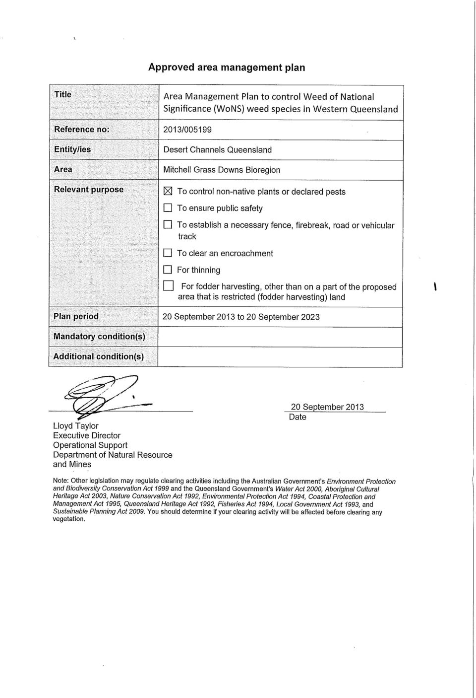
2 Area Management Plan to control Weed of National Significance (WoNS) weed species in Western Queensland Desert Channels Queensland (August 2013) Area Management Plan Purpose To control non-native plants or declared pests plants Management Intent: 1. To carry out control of weed species within the western areas of Queensland which are in high densities; 2. Provide conditions that will allow the native vegetation to be maintained or restored to a functional regional ecosystem over time; and 3. Undertake these activities only on properties with an approved current Desert Channels Queensland (DCQ) 5 Year Weed Plan with control areas, methodologies, monitoring and reporting identified. The weed species targeted are: prickly acacia (Acacia nilotica); mesquite (Prosopis spp.); parkinsonia (Parkinsonia aculeata); and rubber vine (Cryptostegia grandiflora). Management Outcome: 1. Reduction in high density weed infestations in Western Queensland; 2. Improvement in the biodiversity of regional ecosystems; and 3. Improvement in the water quality and habitat of waterways and wetlands. It is expected that hectares per year will have reduced impacts from weed species by work carried out by DCQ through this AMP. Of this area, only hectares per year is expected to be within the sensitive riverine communities. Work will only be undertaken where an approved current DCQ 5 Year weed Plan is in existence and DCQ can provide on-ground monitoring while chemicals are being applied. Area the AMP will cover: The AMP will cover the following shires: Mt Isa, Richmond, Cloncurry, McKinlay, Flinders, Barcaldine, Winton, Boulia, Longreach, Blackall Tambo, Murweh, Quilpie, Diamantina, Barcoo, Bulloo and Paroo. It will only cover these shires where they apply to the Western Bioregions code area as prescribed under the Vegetation Management Act 1999 (VMA). Application of the AMP Application of this AMP will apply in stages. Stage 1 will include the shires of Flinders, Winton, Richmond, McKinlay, Longreach, Barcaldine, Boulia, Blackall-Tambo, Barcoo and Cloncurry. This stage will be in effect from the date of approval ending on 30 June See below for a map of the area. DCQ Weed Area Management Plan August 2013 Page 1
 5 Year Weed Plan with control areas, methodologies, monitoring and reporting identified.")
3 Stage 2 will include the shires of Mt Isa, Diamantina, Murweh, Quilpie, Paroo and Bulloo. This stage will incorporate lessons learnt in stage 1 to address any weed issues surrounding the highly significant wetlands with the shires of this stage. This stage will approximately occur from mid 2017 until mid Reporting DCQ will be required to demonstrate the effectiveness of control operations against the management outcomes following each stage (both stage 1 and stage 2), with reporting to the Chief Executive administering the VMA. Such reporting will require: to be completed within 30 Business Days from the end of the stage; Area of land treated that has been targeted in the stage under the AMP, measured in nonriparian, riparian and riverine. provide details on 10 representative sites subject to the control providing details on the impacts on: weed species using the Bio-condition methodology native vegetation species using the Bio-condition methodology DCQ Weed Area Management Plan August 2013 Page 2
, with reporting to the Chief")
4 Application of latter stages Application of latter stages will occur following review of the reports and where approved by the Chief Executive administering the VMA. Amendment of the AMP Any requests to amend the AMP follows section 20ZC of the VMA (Amendment application for particular plans). Rationale of the AMP This AMP has been designed to control high density weed infestations that are complicated to control using conventional weed control techniques such as basal barking or single machinery. These sites are often complicated because of varying topography combined with the presence of native species. These factors significantly constrain physically accessing the sites and implementing efficient control programs. Often these high density weed infestations are in wetter parts of the landscape such as riparian areas or wetlands. Due to the complicated nature of these weed infestations there is an acknowledgement that native species will be affected through certain control programs targeting these infestations, such as the use of certain herbicides. Although there is expected to be damage to the native species, through the clearing of the weed infestations there will be a subsequent promotion of suitable conditions for recruitment of native species. This will allow for a longer term improvement of the regional ecosystem and its biodiversity values. In addition, it will ensure not only the promotion of the condition of the regional ecosystem subject to the weed control, but also other ecosystems that may be prone to weed infestation from that subject site (for example downstream ecosystems at risk of weed infestation). As a result of the damage predicted to the native species, a risk management process has been conducted to assist with balancing the risk to the native species vulnerable to the weed control program, and the risk to the native species through the lack of control of weed species. This risk management process has assisted in the development in the AMP. Weed control technique: Weeds will be controlled using proven techniques designed for complicated sites in Western Queensland, such as the unmanned aerial vehicle (UAV). Control will be limited in high density sites, which are often in areas with greater water supply, such as riparian areas. The mapping of weed density will be carried out using satellite imagery techniques developed by the Department of Science, Information Technology, Innovation and the Arts (DSITIA) and will indicate areas where the weeds will be targeted. This will be decided based on the strategic nature of the infestation, such as in the head waters of catchments, or that pose risks to high valued assets such as town water supplies and National Parks. This mapping will be qualified for presence of the weed species through either higher resolution imagery (such as SPOT imagery), or through on-ground verification. Once the sites have been determined for control, a property based weed plan will be developed by DCQ and the owner to ensure long term control for the target weed species. This weed plan will be in place prior to work being conducted under this AMP and will exist for a five year period. These weed plans will be developed individually for properties and include as a minimum: spatial areas of weeds subject to control works; control techniques to be implemented (UAV or other techniques); chemical and associated rate; DCQ Weed Area Management Plan August 2013 Page 3

5 monitoring requirement; and requirement for ongoing control. Summary of proposed conditions to be followed for the AMP Clearing only occurs in areas identified through a current approved Desert Channels Queensland five year weed plan. Clearing only occurs for the following non-native plant species: a) prickly acacia (Acacia nilotica); b) mesquite (Prosopis spp.); c) parkinsonia (Parkinsonia aculeata); and d) rubber vine (Cryptostegia grandiflora). Application of root absorbed herbicides is only to be applied outside 30 metres from the drip line of mature trees and is not to be applied on slopes greater than 5% or actively eroding sites. Applying root absorbed herbicides on low slopes allows any herbicide to disintegrate into the soil profile and be taken up by the target weed species following rainfall. Aerial application of foliar applied herbicides is only permitted where it is registered for aerial application under a minor use permit, an emergency use permit or on the product label, and its application occurs strictly in accord with the permit or label conditions. No mature trees are to be directly applied with foliar or basal barking herbicide. Any vegetation debris from the control operations is to be left where it lays, unless it is required to be pushed to allow for access. In Table 9 Regional ecosystems, any canopy vegetation will not be cleared. Access tracks are limited to 4 metres wide and must avoid causing accelerated soil erosion. Any access tracks that cross a stream protection area must be designed to cross perpendicular to the stream. No soil disturbance is to occur in wetland areas or stream protection areas unless as a result of clearing for an access track. No exotic species such as non-native pasture species are to be intentionally introduced by humans as a consequence of control operations. DCQ Weed Area Management Plan August 2013 Page 4
; c) parkinsonia (Parkinsonia aculeata); and d) rubber vine (Cryptostegia grandiflora).")
6 Explanation of how the clearing proposal is not inconsistent with the RVM code Performance Requirement Code Acceptable Solution AMP solution and proposed conditions PR W.1 Limits to clearing for weed or pest management To regulate the clearing of vegetation in a way that conserves remnant vegetation that are regional ecosystems, does not cause land degradation, prevents the loss of biodiversity and maintains ecological processes subject to the limitations required to meet PR W.2 to PR W.7 clearing is limited to the extent necessary to a) control non-native plants or declared pests; or b) provide access for control of nonnative plants or declared pests if no alternative route exists PR W.2: Wetlands To regulate the clearing of vegetation in a way that prevents the loss of Nil AS W.2 W.2.1 Clearing and associated soil disturbance within a) any natural wetland; and Any proposed control areas will only occur in areas mapped out through DSITIA methodology and that are planned for in the DCQ weed plan. These areas will be shown spatially within the DCQ weed plan. Clearing under this AMP will only be limited to those areas where there is a dense infestation of the prescribed weed species and that is mapped through a developed DCQ weed plan. Such an approach will ensure that clearing under this AMP is limited to the extent necessary, using both the best available information and that it is identified subsequently through best practice weed plans. Such an approach will ensure that areas without weed infestations are not cleared under this AMP. Proposed AMP condition Clearing only occurs in areas identified through a current approved Desert Channels Queensland five year weed plan. Clearing only occurs for the following non-native plant species: a) prickly acacia (Acacia nilotica); b) mesquite (Prosopis spp.); c) parkinsonia (Parkinsonia aculeata); and d) rubber vine (Cryptostegia grandiflora). Clearing will occur in a very targeted fashion using an unmanned aerial vehicle or other proven technique, ensuring precision when applying the chemical application. However during the application, there is likely to be non canopy species DCQ Weed Area Management Plan August 2013 Page 5
 control non-native plants or declared pests; or b) provide access for control of nonnative plants or declared pests if no alternative route exists")
7 biodiversity and maintains ecological processes assessable vegetation associated with any natural significant wetland and/or natural wetland is protected to maintain a) water quality by filtering sediments, nutrients and other pollutants; and b) aquatic habitat; and c) terrestrial habitat. b) 100 metres from any natural wetland; and c) any natural significant wetland; and d) 200 metres from any natural significant wetland occurs only i) within a 1.5 metre radius from the base of the stem of individual non-native or declared plants, or within a 3 metre radius around each hole of a rabbit warren; and ii) to the extent necessary to provide access for the control of the non-native or declared plant or to the rabbit warren if no alternative route exists, unless the clearing is to control or provide access to an animal or plant declared as a class 1 or 2 pest under the Land Protection (Pest and Stock Route Management) Act 2002 for which there is a pest eradication plan in place and is carried out in accordance with that plan. within the targeted areas affected by the control. This will be as a result of lack of seeing them because of the density of the weed species, but also to allow for operational efficiencies in treating the areas in a comprehensive way. However, mature species present during the control, will be avoided by not applying any control method within 30m of the drip line of the mature trees. In addition any soil applied herbicide will only be applied on low slopes (less than 5%), ensuring that any granular herbicide will disintegrate into the soil profile and be taken up by the prickly acacia, rather than moving downstream affecting non-target species. Such a control technique will ensure that the PR is met, because mature vegetation will be retained, ensuring their ongoing role in water quality, aquatic habitat and terrestrial habitat maintenance. Weed species will be left where they are controlled, ensuring that they play a role in maintaining the bank structure of the wetland, maintaining water quality features. In addition, leaving dead stags will provide certain value as aquatic and terrestrial habitat. No soil disturbance will occur from the clearing event, ensuring maintenance of water quality in the wetland buffer areas as prescribed by the code. The clearing of the weed species will allow for natural recruitment of native species in the area, re-establishing the regional ecosystems characteristics, thereby promoting the aquatic and terrestrial habitat of the natural community. In addition re-establishing the natural diversity of the area with a greater species life form such as shrubs and grasses will also lead to a greater level of water quality improvement. DCQ Weed Area Management Plan August 2013 Page 6
 to the extent necessary to provide access")
8 No clearing will be required through wetland areas for an access track ensuring no soil disturbance to wetland area. Proposed AMP condition Application of root absorbed herbicides is only to be applied outside 30 metres from the drip line of mature trees and is not to be applied on slopes greater than 5% or actively eroding sites. Applying root absorbed herbicides on low slopes allows any herbicide to disintegrate into the soil profile and be taken up by the target weed species following rainfall. No mature trees are to be directly applied with foliar or basal barking herbicide. Aerial application of foliar applied herbicides is only permitted where it is registered for aerial application under a minor use permit, an emergency use permit or on the product label, and its application occurs strictly in accord with the permit or label conditions. Access tracks are limited to 4 metres wide and must avoid causing accelerated soil erosion. Any access tracks that cross a stream protection area must be designed to cross perpendicular to the stream. No soil disturbance is to occur in wetland areas or stream protection areas unless as a result of clearing for an access track. PR W.3: Watercourses To regulate the clearing of vegetation in a way that does not cause land degradation, prevents the loss of biodiversity and AS W.3 W.3.1 Clearing and associated soil disturbance within a) any watercourse; and b) 200 metres from each high bank of each watercourse with a stream order 5 or greater; Similar to the wetland PR - clearing will occur in a very targeted fashion using an unmanned aerial vehicle or other proven technique, ensuring precision when applying the chemical application. However during the application, there is likely to be non canopy species within the areas that will be affected by the control. This will be as a result of lack of seeing DCQ Weed Area Management Plan August 2013 Page 7

9 maintains ecological processes assessable vegetation associated with any watercourse is protected to maintain a) bank stability by protecting against bank erosion; and b) water quality by filtering sediments, nutrients and other pollutants; and c) aquatic habitat; and d) terrestrial habitat. and c) 100 metres from each high bank of each watercourse with a stream order 3 or 4; and d) 50 metres from each high bank of each watercourse with a stream order 1 or 2, occurs only i) within a 1.5 metre radius from the base of the stem of individual non-native or declared plants or within a 3 metre radius around each hole of a rabbit warren; and ii) to the extent necessary to provide access for the control of the non-native or declared plant or to the rabbit warren if no alternative route exists, unless the clearing is to control or provide access to an animal or plant declared as a class 1 or 2 pest under the Land Protection (Pest and Stock Route Management) Act 2002 for which there is a pest eradication plan in place and is carried out in accordance with that plan them because of the density of the weed species, but also to allow for operational efficiencies in treating the areas. However, mature species present during the control, will be avoided by not applying any control method within 30 metres of the drip line of the mature trees and only applying granular herbicide on low slopes. Such a control technique will ensure that PR is met, because mature vegetation will be retained, ensuring their ongoing role in water quality, aquatic habitat and terrestrial habitat maintenance as well as supporting bank stability. Weed species controlled will be left where they are controlled, ensuring that they play a role in maintaining the bank structure of the riparian area, maintaining water quality features, as well as providing certain features from stags in the provision of aquatic and terrestrial habitat. No soil disturbance will occur from the clearing event, allowing for maintenance of water quality. The clearing of the weed species will allow for natural recruitment of native species in the area, re-establishing the regional ecosystems characteristics, thereby promoting the aquatic and terrestrial habitat of the nature community. In addition, re-establishing the natural diversity of the area with a greater species form (grass, shrubs, saplings etc.) present in the area will lead to a greater level of water quality improvement. No clearing for an access track will be required in riparian areas Proposed AMP condition Application of root absorbed herbicides is only to be applied outside 30 metres from the drip line of mature trees and is not to be applied on slopes greater than 5% DCQ Weed Area Management Plan August 2013 Page 8
 to the extent necessary to provide access")
10 or actively eroding sites. Applying root absorbed herbicides on low slopes allows any herbicide to disintegrate into the soil profile and be taken up by the target weed species following rainfall. No mature trees are to be directly applied with foliar or basal barking herbicide. Aerial application of foliar applied herbicides is only permitted where it is registered for aerial application under a minor use permit, an emergency use permit or on the product label, and its application occurs strictly in accord with the permit or label conditions Access tracks are limited to 4 metres wide and must avoid causing accelerated soil erosion. Any access tracks that cross a stream protection area must be designed to cross perpendicular to the stream. No soil disturbance is to occur in wetland areas or stream protection areas unless as a result of clearing for an access track. PR W.4: Soil erosion To regulate the clearing of vegetation in a way that does not cause land degradation and maintains ecological processes the effect of clearing does not result in a) mass movement, gully erosion, rill erosion, sheet erosion, tunnel erosion, stream bank erosion, wind erosion, or scalding; and b) any associated loss of chemical, AS W.4 W.4.1 Clearing and associated soil disturbance on a) stable soils on a slope greater than 10%; and b) unstable soils on a slope greater than 3%; and c) very unstable soils on a slope greater than 1%, occurs only i) within a 1.5 metre radius from the base of the stem of individual non-native or declared plants or within a 3 metre radius around each hole of a rabbit warren; and ii) to the extent necessary to provide access for the control of the non-native or declared plant or to the rabbit warren if no alternative Clearing will be in a very targeted fashion and all vegetation cleared will be left where it lay. There will be no soil disturbance as a result of this clearing technique. As all the vegetation will be left where it remains following death, it will naturally decompose maintaining for as long as possible the root structure in the soil. Such a technique will ensure that the PR is met, because clearing will not result in any of the erosion issues listed in the PR. Furthermore, the clearing will not result in any associated loss of chemical, physical or biological integrity. Rather, through the control of weed species, it will allow for the recruitment of the natural species in the regional ecosystem, promoting natural cover protecting the value of the land resource. DCQ Weed Area Management Plan August 2013 Page 9

11 physical or biological fertility including, but not limited to water holding capacity, soil structure, organic matter, soil biology, and nutrients, within and/or outside the lot(s)that are the subject of the application. PR W.5: Conserving remnant vegetation that are regional ecosystems To regulate the clearing of vegetation in a way that conserves remnant vegetation that are regional ecosystems, does not cause land degradation, prevents the loss of biodiversity and maintains ecological processes clearing activities a) maintain the natural floristic composition route exists, unless the clearing is to control or provide access to an animal or plant declared as a class 1 or 2 pest under the Land Protection (Pest and Stock Route Management) Act 2002 for which there is a pest eradication plan in place and is carried out in accordance with that plan. AS W.5 W.5.1 Clearing to control and/or provide access to an animal or plant declared as a class 1 or 2 pest under the Land Protection (Pest and Stock Route Management) Act 2002 occurs only a) in accordance with a pest eradication plan; and b) to the extent necessary to provide access for the control of the class 1 or 2 pest if no alternative route exists. OR W.5.2 Where clearing is to control and/or provide In some situations, clearing for an access track may be required to allow for flying of the UAV and maintaining line of sight for the UAV. Where an access track is required, clearing will only occur to the extent necessary and will only occur up to 4 metres wide; and not cause accelerated soil erosion. Proposed AMP condition Access tracks are limited to 4 metres wide and must avoid causing accelerated soil erosion. Any access tracks that cross a stream protection area must be designed to cross perpendicular to the stream. No soil disturbance is to occur in wetland areas or stream protection areas unless as a result of clearing for an access track. Any vegetation debris from the control operations is to be left where it lays, unless it is required to be pushed to allow for access. Clearing will be carried out in highly weed infested areas. These weed species have been present for a minimum of 5 years, but potentially much longer (10 years plus), resulting in a significant modification to the natural community. Often the areas only contain mature vegetation, with minor or nonexistent populations of understorey species. To ensure effective control of these areas and allow for natural recruitment of native species following control, current under storey native species will be affected by the control. However, long term, these areas, through the removal of these weed species will contain suitable conditions for natural recruitment. DCQ Weed Area Management Plan August 2013 Page 10
 maintain the natural floristic composition route exists, unless the clearing is to control or")
12 and range of sizes of each species of the regional ecosystem evenly spaced across the application area; and b) do not remove mature trees. access to a non-native or declared plant, clearing a) to control the declared or non-native plant i) must be in accordance with the limitations set out in Table 8; and ii) does not occur by the aerial application of root absorbed herbicides; and b) occurs only to the extent necessary to provide access for the control of the declared or non-native plant if no alternative route exists. OR W.5.3 Clearing to control a declared pest animal under the Land Protection (Pest and Stock Route Management) Act 2002 occurs only a) within a 3 metre radius around each hole of a rabbit warren; and b) to the extent necessary to provide access to a rabbit warren if no alternative route exists. To meet the PR, mature trees will not controlled by the UAV, by ensuring all chemical application is applied 30 metres outside the drip line. In relation to part a) of the PR - maintaining the natural floristic composition and range of sizes of each species of the RE will not be possible for two reasons, which include: due to the difficulty of measuring the current status of understorey species at the sites. Because of access and health and safety issues, it will be unknown what the current floristic composition is; and control operations will likely affect understorey species present both to allow for operational efficiency and because they cannot be seen by the UAV pilot in undertaking operations. However, carrying out weed control to promote the reestablishment of the native community will ensure that the purposes of the VMA, and subsequently the code are met. Removing existing native understorey species will result in a short term decrease to the current natural floristic composition. However, at these sites the vegetation community is at a very low level of floristic composition because of the dominance of weed species, resulting in a site that is highly degraded. Once the weed species are controlled, this will allow for an increase in the natural floristic composition, improving the value of the area and increasing the biodiversity value of the site. DCQ Weed Area Management Plan August 2013 Page 11
 Act 2002 occurs only a) within a 3 metre radius around each hole of a rabbit warren; and b) to")
13 DCQ Weed Area Management Plan August 2013 Page 12 Such a clearing proposal then, promotes the purposes of the VMA and the RVM code. In particular, by removing a significant threatening process to the community, the following purposes will be met: conserving remnant vegetation; prevents the loss of biodiversity; and maintains and improves ecological processes. To meet part a) of the PR, it is therefore proposed that this AMP is not inconsistent with the regional vegetation management code for the plan area, because the outcome of this clearing will actually promote the purposes of the VMA, and subsequently the outcomes promoted by the RVM code. Proposed AMP condition Application of root absorbed herbicides is only to be applied outside 30 metres from the drip line of mature trees and is not to be applied on slopes greater than 5% or actively eroding sites. Applying root absorbed herbicides on low slopes allows any herbicide to disintegrate into the soil profile and be taken up by the target weed species following rainfall. No mature trees are to be directly applied with foliar or basal barking herbicide. No exotic species such as non-native pasture species are to be intentionally introduced by humans as a consequence of control operations. Aerial application of foliar applied herbicides is only permitted where it is registered for aerial application under a minor use permit, an emergency use permit or on the product label, and its application occurs strictly in accord with the permit or label conditions PR W.6: Requirements for dense AS W.6 It is unlikely that any clearing will occur in Table 9 regional
 of the PR, it is therefore proposed that this AMP is not inconsistent with the regional vegetation management code for the plan area, because the outcome of this clearing will")
14 regional ecosystems To regulate the clearing of vegetation in a way that conserves remnant vegetation that are regional ecosystems, prevents the loss of biodiversity and maintains ecological processes removal of canopy vegetation does not occur in regional ecosystems listed in Table 9. W.6.1 Clearing and associated soil disturbance in regional ecosystems listed in Table 9 occurs only a) within a 1.5 metre radius from the base of the stem of individual non-native or declared plants or within a 3 metre radius around each hole of a rabbit warren; and b) to the extent necessary to provide access for the control of the non-native or declared plant or to the rabbit warren if no alternative route exists, unless the clearing is to control or provide access to an animal or plant declared as a class 1 or 2 pest under the Land Protection (Pest and Stock Route Management) Act 2002 for which there is a pest eradication plan in place and is carried out in accordance with that plan. ecosystems However, in any clearing operation, no mature trees will be cleared. Where clearing occurs in a Table 9 regional ecosystem, and it contains canopy vegetation that does not meet the mature definition in this AMP, no clearing will occur. Proposed AMP condition Application of root absorbed herbicides is only to be applied outside 30 metres from the drip line of mature trees and is not to be applied on slopes greater than 5% or actively eroding sites. Applying root absorbed herbicides on low slopes allows any herbicide to disintegrate into the soil profile and be taken up by the target weed species following rainfall. In Table 9 Regional ecosystems, any native canopy vegetation will not be cleared. PR W.7: Acid sulfate soils To regulate the clearing of vegetation in a way that does not cause land degradation and maintains ecological processes clearing activities do not result in disturbance of acid sulfate soils or changes to the hydrology of the location that will either a) aerate horizons containing iron sulfides; or b) mobilise acid and/or metals AS W.7 W.7.1 Clearing in land zone 1, land zone 2 or land zone 3 in areas below 5 metre Australian Height Datum a) is carried out in accordance with an acid sulfate soils environmental management plan as outlined in the State Planning Policy 2/02 Guideline: Planning and Managing Development involving Acid Sulfate Soils; and b) follows management principles in accordance with the Soil Management Guidelines in The clearing will occur only in inland areas and will not be subject to any coastal related land zones 1, 2 and 3. Furthermore, in the unlikely presence of Acid sulphate soil properties present in inland areas, there will be no soil disturbance associated with the clearing operation that would expose soil horizons containing iron sulphides, and thereby lead to mobilisation of acids and/or metals. This clearing proposal meets the PR. Proposed AMP condition DCQ Weed Area Management Plan August 2013 Page 13
 to the extent necessary to provide access")
15 the Queensland Acid Sulfate Soil Technical Manual unless the clearing is to control or provide access Any vegetation debris from the control operations is to be left where it lays, unless it is required to be pushed to allow for access. to an animal or plant declared as a class 1 or 2 pest under the Land Protection (Pest and Stock Route Management) Act 2002 for which there is a pest eradication plan in place and is carried out in accordance with that plan. Definitions Mature trees are native trees and shrubs which are over the size limits specified below Eucaltypts, Corymbia, Angophora, Lophestemon - >30 cm at 1.3m diameter; and Genera other than Eucalypts, Corymbia, Angophora and Lophostemon - >20 cm at 1.3m diameter. Table 9 Regional Ecosystems - As listed in the Regional Vegetation Management code for Western Bioregions version 2.1 effective from 30 November Possible REs relevant to the area may include the following: Semi-evergreen vine thicket on red kandosols on Tertiary plateaus Semi-evergreen vine thicket on Quaternary basalt soils Semi-evergreen vine thicket on cones, craters and rocky basalt flows with little soil development Semi-deciduous vine thicket on limestone rock outcrops Semi-deciduous vine thicket on metamorphic soils (not limestone) Semi-evergreen vine thicket on rocky outcrops and shallow soils of acid volcanic rocks Semi-evergreen vine thicket with Araucaria cunninghamii on steep hills on acid and intermediate volcanic rocks Acacia torulosa shrubland or Triodia longiceps hummock grassland on weathered lake dunes Shrublands on shallow earths, with species including Melaleuca tamariscina and Acacia leptostachya Acacia cambagei woodland on Cainozoic clay plains Semi-evergreen vine thicket on Cainozoic sand plains/remnant surfaces Semi-evergreen vine thicket in sheltered habitats on medium to coarse-grained sedimentary rocks Microphyll vine forest ± Araucaria cunninghamii on old sedimentary rocks with varying degrees of metamorphism and folding Semi-evergreen vine thicket and microphyll vine forest on igneous rocks Montane shrubland on igneous rocks. Mountain tops DCQ Weed Area Management Plan August 2013 Page 14

16 Wetland areas - The area o In and within 100 metres of a wetland; and o In and within 200 metres of a significant wetland. - Where a wetland is the area of land that supports plants or is associated with plants that are adapted to and dependent on living in wet conditions for at least part of their life cycle, and that is o a) a regional ecosystem listed Table 13 of the Regional Vegetation Management code for Western Bioregions version 2.1 effective from 30 November 2012; or o b) the area on the ground represented as a swamp, lake, marsh, waterhole, wetland, billabong, pool, spring or like represented on the most recent, finest scale i. Geoscience Australia topographic map or data that shows swamps, lakes, marshes, waterholes, wetlands, billabongs, pools, springs or like which can be accessed at the following internet address: ; or ii. topographic data that represents swamps, lakes, marshes, waterholes, wetlands, billabongs, pools, springs or like which is publicly available from the Department of Natural Resources and Mines. o c) listed as an active spring in the Queensland Springs Database, which can be accessed at the following internet address: - Where a significant wetland the area of land that supports plants or is associated with plants that are adapted to and dependent on living in wet conditions for at least part of their life cycle and that is o i. a regional ecosystem listed in Table 14 of the Regional Vegetation Management code for Western Bioregions version 2.1 effective from 30 November 2012 and the area on the ground is represented as a swamp, lake, marsh, waterhole, wetland, billabong, pool, spring or like, on the most recent 1: Geoscience Australia topographic map of the area; or o ii. a Ramsar wetland. Stream Protection Area - The area o In and within 200 metres from each high bank of each watercourse with a stream order 5 or greater; and o In and within 100 metres from each high bank of each watercourse with a stream order 3 or 4; and o In and within 50 metres from each high bank of each watercourse with a stream order 1 or 2. DCQ Weed Area Management Plan August 2013 Page 15
 the area on the ground represented as a swamp, lake, marsh, waterhole, wetland, billabong, pool, spring or like represented on the most recent, finest scale")
17 - Where a watercourse is that shown on the Vegetation Management Watercourse Map. - Where stream order is a numerical ordering classification of each watercourse segment according to its position within a catchment, as shown in below. Stream orders are determined using the vegetation management watercourse map. DCQ Weed Area Management Plan August 2013 Page 16

18 DCQ Weed Area Management Plan August 2013 Page 17

1.7.0 Floodplain Modification Criteria
 1.7.0 Floodplain Modification Criteria 1.7.1 Introduction These guidelines set out standards for evaluating and processing proposed modifications of the 100- year floodplain with the following objectives:
How To Plan A Buffer Zone
 Backyard Buffers Protecting Habitat and Water Quality What is a buffer? A buffer (also called a riparian buffer area or zone) is the strip of natural vegetation along the bank of a stream, lake or other
Department of Natural Resources and Mines. Offset Area Management Plan Template December 2012. Offset Area Management Plan - Inderi
 Department of Natural Resources and Mines Offset Area Management Plan Template December 2012 Offset Area Management Plan - Inderi State of Queensland, Department of Natural Resources and Mines, 2012. The
Waterway Technote Planning
 Waterway Technote Planning Contents Benefits to planning your waterway management 1 Prioritising waterway management where to start? 1 What are your priorities? 1 Start with the best areas or those at
GLOSSARY OF TERMS CHAPTER 11 WORD DEFINITION SOURCE. Leopold
 CHAPTER 11 GLOSSARY OF TERMS Active Channel The channel that contains the discharge Leopold where channel maintenance is most effective, sediment are actively transported and deposited, and that are capable
Communities, Biomes, and Ecosystems
 Communities, Biomes, and Ecosystems Before You Read Before you read the chapter, respond to these statements. 1. Write an A if you agree with the statement. 2. Write a D if you disagree with the statement.
Waterway Technote Drains
 Waterway Technote Drains Contents Benefits of good drain practice 1 Are your drains healthy? 2 The Sustainable Dairying Water Accord 3 Planning drain maintenance 3 Fencing and clearing 3 Bank shaping (battering)
LOW INTEREST LOANS FOR AGRICULTURAL CONSERVATION
 LOW INTEREST LOANS FOR AGRICULTURAL CONSERVATION LILAC MANUAL LOW INTEREST LOANS FOR AGRICULTURAL CONSERVATION TABLE OF CONTENTS Introduction... 3 General Eligibility... 4 Specific Eligibility Criteria
FOREST RESTORATION MONITORING TOOL
 FOREST RESTORATION MONITORING TOOL Draft version for field test INTRODUCTION FAO upon recommendation of its members identified the need to initiate a comprehensive analysis, evaluation and documentation
Queensland Parks and Wildlife Service PEST MANAGEMENT PLAN
 QPWS Pest Management Plan Queensland Parks and Wildlife Service PEST MANAGEMENT PLAN 2010-2015 A plan to meet obligations under the Land Protection (Pest and Stock Route Management) Act (2002) Version:
Rural Flooding: The Potential Role of Forestry
 Rural Flooding: The Potential Role of Forestry Nadeem Shah, Tom Nisbet, & Huw Thomas Centre for Forestry and Climate Change Structure Background Woodland and Flood Alleviation The Theory. Studies on Woodland
Chapter 3 Communities, Biomes, and Ecosystems
 Communities, Biomes, and Ecosystems Section 1: Community Ecology Section 2: Terrestrial Biomes Section 3: Aquatic Ecosystems Click on a lesson name to select. 3.1 Community Ecology Communities A biological
3.1. Succession, Recovery, and Renewal in Natural Communities. A35 Starting Point. What Happens to a Vacant Lot?
 3.1 Succession, Recovery, and Renewal in Natural Communities Here is a summary of what you will learn in this section: Ecosystems change in predictable ways known as succession. Ecosystems can establish
Approved Natural Disaster Recovery Round Green Army projects
 Approved Natural Disaster Recovery Round Green Army projects Project Title Project Description State Territory Belmont Wetlands East Coast This project will reduce erosion and revegetate and control weeds
Post-Wildfire Clean-Up and Response in Houston Toad Habitat Best Management Practices
 Post-Wildfire Clean-Up and Response in Houston Toad Habitat Best Management Practices Purpose The purpose of this document is to provide guidance and recommendations for minimizing potential impacts to
Appendix C. Municipal Planning and Site Restoration Considerations
 Appendix C Municipal Planning and Site Restoration Considerations 67 68 Appendix C - Municipal Planning and Site Restoration Considerations This appendix contains best practice standards for site planning
REPORT TO REGIONAL WATER SUPPLY COMMISSION MEETING OF WEDNESDAY, SEPTEMBER 4, 2013 LEECH WATER SUPPLY AREA RESTORATION UPDATE
 Making a difference... together Agenda Item #9 REPORT #RWSC 2013-17 REPORT TO REGIONAL WATER SUPPLY COMMISSION MEETING OF WEDNESDAY, SEPTEMBER 4, 2013 SUBJECT LEECH WATER SUPPLY AREA RESTORATION UPDATE
Environmentally Significant Areas of Alberta. Volume 3. Prepared by: Sweetgrass Consultants Ltd. Calgary, AB. for:
 Environmentally Significant Areas of Alberta Volume 3 Prepared by: Calgary, AB for: Resource Data Division Alberta Environmental Protection Edmonton, Alberta March 1997 EXECUTIVE SUMMARY Large portions
SANTA BARBARA COUNTY COMPREHENSIVE PLAN LOMPOC AREA
 SANTA BARBARA COUNTY COMPREHENSIVE PLAN LOMPOC AREA A. LAND USE ELEMENT INTERPRETIVE GUIDELINES B. COMMUNITY BENEFITS C. COUNTY ACTION ITEMS Adopted by the Board of Supervisors November 9, 1999 A. Santa
APPENDIX D. EXAMPLES OF OTHER FORMATION-LEVEL CLASSIFICATIONS
 APPENDIX D. EXAMPLES OF OTHER FORMATION-LEVEL CLASSIFICATIONS Main World Terrestrial Biome Types (Box and Fujiwara 2005, Table 4.4,) The authors provide 18 major biome types recognized by most modern treatments
4.2 Buena Vista Creek Watershed
 Buena Vista Creek Watershed 4.2 Buena Vista Creek Watershed Watershed Overview The Buena Vista Creek Watershed is the fourth-largest system within the Carlsbad Hydrologic Unit. The watershed extends approximately
Addendum D. Nomination of Moody Wash ACEC
 Addendum D Nomination of Moody Wash ACEC Moody Wash ACEC is hereby nominated by Citizens for Dixie s Future to: BLM St. George Field Office 345 East Riverside Drive St. George, UT 84790 Moody Wash is a
SUPPLEMENTARY EVIDENCE OF SHONA CLAIRE MYERS ON BEHALF OF THE KAPITI COAST DISTRICT COUNCIL. Terrestrial ecology. DATE: 3 February 2012
 BEFORE A BOARD OF INQUIRY TRANSMISSION GULLY PROPOSAL UNDER the Resource Management Act 1991 IN THE MATTER OF applications for resource consents and notices of requirement in relation to the Transmission
THE NATURAL RESOURCES AND ENVIRONMENT ORDINANCE (CAP. 84 - LAWS OF SARAWAK, 1958 Ed.)
") THE NATURAL RESOURCES AND ENVIRONMENT ORDINANCE (CAP. 84 - LAWS OF SARAWAK, 1958 Ed.) THE NATURAL RESOURCES AND ENVIRONMENT (PRESCRIBED ACTIVITIES) ORDER, 1994 (Made under section 11A(1)) (Incorporating
THE NATURAL RESOURCES AND ENVIRONMENT ORDINANCE (CAP. 84 - LAWS OF SARAWAK, 1958 Ed.) THE NATURAL RESOURCES AND ENVIRONMENT (PRESCRIBED ACTIVITIES) ORDER, 1994 (Made under section 11A(1)) (Incorporating
Backyard Buffers that Work for People and Nature by Restoring Ecological Function
 Backyard Buffers that Work for People and Nature by Restoring Ecological Function What is a Wetland Buffer? A wetland buffer is a simple land management practice that is employed by municipalities to protect
Bioregional Conservation Status for each BioEVC
 Bridgewater 3 Damp Sands Herb-rich Woodland Vulnerable Bridgewater 9 Coastal Saltmarsh Vulnerable Bridgewater 10 Estuarine Wetland Endangered Bridgewater 23 Herb-rich Foothill Forest Vulnerable Bridgewater
Restoration Planning and Development of a Restoration Bank
 Restoration Planning and Development of a Restoration Bank Black Creek Pioneer Village, South Theatre 8:30 a.m. to 3:30 p.m. Habitat Restoration and Environmental Monitoring Projects Section Restoration
Climate, Vegetation, and Landforms
 Climate, Vegetation, and Landforms Definitions Climate is the average weather of a place over many years Geographers discuss five broad types of climates Moderate, dry, tropical, continental, polar Vegetation:
King Fire Restoration Project, Eldorado National Forest, Placer and El Dorado Counties, Notice of intent to prepare an environmental impact statement.
 This document is scheduled to be published in the Federal Register on 12/24/2014 and available online at http://federalregister.gov/a/2014-30158, and on FDsys.gov [3410-11- P] DEPARTMENT OF AGRICULTURE
Application of Invest`s Sedimentation Retention model for restoration benefits forecast at Cantareira Water Supply System
 Application of Invest`s Sedimentation Retention model for restoration benefits forecast at Cantareira Water Supply System Introduction Healthy forests regulate water flows, protect watercourses and maintain
Most informed people realize that cumulative impacts have had
 Welcome to the First Issue of Rivers & Coast! The goal of the new Rivers & Coast newsletter is to keep readers well informed of current scientific understanding behind key environmental issues related
Controlling Invasive Plants and Animals in our Community
 Controlling Invasive Plants and Animals in our Community PROVIDED BY THE WILDLIFE COMMITTEE What makes a plant or animal invasive? When a plant or animal from another region of the world (usually Europe
WEATHERING, EROSION, AND DEPOSITION PRACTICE TEST. Which graph best shows the relative stream velocities across the stream from A to B?
 NAME DATE WEATHERING, EROSION, AND DEPOSITION PRACTICE TEST 1. The diagram below shows a meandering stream. Measurements of stream velocity were taken along straight line AB. Which graph best shows the
WILLOCHRA BASIN GROUNDWATER STATUS REPORT 2009-10
 WILLOCHRA BASIN GROUNDWATER STATUS REPORT 2009-10 SUMMARY 2009-10 The Willochra Basin is situated in the southern Flinders Ranges in the Mid-North of South Australia, approximately 50 km east of Port Augusta
Angora Fire Restoration Activities June 24, 2007. Presented by: Judy Clot Forest Health Enhancement Program
 Angora Fire Restoration Activities June 24, 2007 Presented by: Judy Clot Forest Health Enhancement Program California Tahoe Conservancy Independent California State Agency within the Resources Agency Governed
SITE WEED MANAGEMENT PLAN FOR. (NAME of PRESERVE or CONSERVATION AREA) (TOWN, STATE) (PERIOD; e.g. 2001-2005)
 (TOWN, STATE) (PERIOD; e.g. 2001-2005)") Site Weed Management Plan Template TNC s Wildland Invasive Species Program Revised: Mandy Tu & Barry Meyers-Rice/WISP SITE WEED MANAGEMENT PLAN FOR (NAME of PRESERVE or CONSERVATION AREA) (TOWN, STATE)
Site Weed Management Plan Template TNC s Wildland Invasive Species Program Revised: Mandy Tu & Barry Meyers-Rice/WISP SITE WEED MANAGEMENT PLAN FOR (NAME of PRESERVE or CONSERVATION AREA) (TOWN, STATE)
Integrated Weed Management in Portland Parks
 Urban Pest Management Course February 6, 2013 Integrated Weed Management in Portland Parks Commissioner Nick Fish www.portlandparks.org Director Mike Abbaté Commissioner www.portlandparks.org Jim Francecsconi
Ecological Restoration of a Brackish Marsh at Parcel 11, Estate Carolina, St. John
 Ecological Restoration of a Brackish Marsh at Parcel 11, Estate Carolina, St. John Gary Ray, Ph.D. Virgin Forest Restorations For Coral Bay Community Council Aerial of Parcel 11 Brackish Marsh Ecological
2015 AVAGO 2D SEISMIC SURVEY ENVIRONMENTAL MANAGEMENT PLAN SUMMARY
 ENVIRONMENTAL MANAGEMENT PLAN SUMMARY TABLE OF CONTENTS 1. INTRODUCTION... 3 2. DESCRIPTION OF ACTIVITY... 4 3. DESCRIPTION OF THE ENVIRONMENT... 4 4. DESCRIPTION OF THE ACTIVITY IN RELATION TO THE ENVIRONMENT...
3. Design Procedures. Design Procedures. Introduction
 Design Procedures 3. Design Procedures Introduction This chapter presents a procedure for the design of natural channels. The chapter primarily focuses on those physical properties of the channel required
APPLICATION OF GEOSPATIAL TECHNOLOGIES FOR SUSTAINABLE ENVIRONMENTAL MANAGEMENT
 APPLICATION OF GEOSPATIAL TECHNOLOGIES FOR SUSTAINABLE NATURAL RESOURCES AND ENVIRONMENTAL MANAGEMENT IN MALAYSIA By James Dawos Mamit, Ph.D. Deputy Minister Ministry of Natural Resources and Environment,
Land Cover Mapping of the Comoros Islands: Methods and Results. February 2014. ECDD, BCSF & Durrell Lead author: Katie Green
 Land Cover Mapping of the Comoros Islands: Methods and Results February 2014 ECDD, BCSF & Durrell Lead author: Katie Green About the ECDD project The ECDD project was run by Bristol Conservation & Science
Madagascar: Makira REDD+
 project focus Madagascar: Makira REDD+ Madagascar is considered to be one of the top five biodiversity hotspots in the world due to more than 75% of all animal and plant species being endemic while less
Chapter 7. Topography, geology, soils and groundwater. Chapter 7
 Chapter 7 Topography, geology, soils and groundwater Chapter 7 7.0 Topography, geology, soils and groundwater 7.1 Introduction and approach A detailed assessment of the existing topographic, geological,
2.1 Environmental Responsibility & Land Capability
 2.1 Environmental Responsibility & Land Capability Introduction The Land use permissibility of a development in a particular under the zone, as indicated by the Lake Macquarie LEP 2004 does not mean indication
Ch. 15-Restoration Ecology
 Ch. 15-Restoration Ecology Conservation focuses on protecting and maintaining diversity and ecological processes Restoration emphasizes active management to bring back a former state of an ecosystem (
Guide to agrichemical use in Resource Management Plans Northland Region as at October 2011
 Guide to agrichemical use in Resource Management Plans Northland Region as at October 2011 Northland Regional Air Quality Plan Note: This guide is intended to assist users and applicators understanding
Carlton Fields Memorandum
 Carlton Fields Memorandum TO: FROM: RE: DAN WEEDE FRED RUSHING RIPARIAN BUFFER DATE: JULY 26, 2013 BACKGROUND Both the state of Georgia and the city of Atlanta 1 have certain guidelines that must be followed
Basic Soil Erosion and Types
 Basic Soil Erosion and Types 2015 Wisconsin Lakes Convention Stacy Dehne DATCP Engineer Types of Soil Erosion Rain drop or splash erosion: Erosion preceded by the destruction of the crumb structure due
National Inventory of Landscapes in Sweden
 Key messages Approaching the landscape perspective in monitoring experiences in the Swedish NILS program Johan Svensson, Future Forest Monitoring, 091112 Landscape level approaches are necessary to deal
Division of Forestry
 Guidelines for Managing Sites with Ash To Address the Threat of Emerald Ash Borer On Forestry-Administered Lands BACKGROUND The ash genus (Fraxinus) in Minnesota comprises some 900 million trees and is
Dysart Road and Associated Services Infrastructure Project Compliance Report Environment Protection and Biodiversity Conservation Act 1999
 Dysart Road and Associated Services Infrastructure Project Compliance Report Environment Protection and Biodiversity Conservation Act 1999 March 2015 About this report In accordance with condition 6 of
1 Introduction. 1.1 Key objective. 1.2 Why the South Esk
 1 Introduction 1.1 Key objective The aim of this study is to identify and assess possible options for improving the quality of the river channel and habitats in the River South Esk catchment whilst helping
TEMPLATE FOR WATER TAKE CONSENT
 RIPARIAN VEGETATION MANAGEMENT PLAN TEMPLATE FOR WATER TAKE CONSENT Required for rule 3.3.4.19 of the Waikato Regional Plan Variation 6 Water Allocation The Waikato Regional Plan has allowed for grandparenting
Remote sensing for the MTS
 Remote sensing for the MTS Jennifer M. Wozencraft Director, Program Manager, USACE National Coastal Mapping Program 24 June 2014, Innovative Technologies for a Resilient MTS Outline Background JALBTCX
Various options are discussed below.these low cost, low impact interventions can also be applied as general erosion control methods.
 Week 10 River Hydraulics Rehabilitating Urban Waterways (From http://hubpages.com/hub/river-bank-erosion-control-methods) See also the resources placed on Moodle. Water channels should be viewed as a resource
A Developer s Guide: Watershed-Wise Development
 A Developer s Guide: Watershed-Wise Development Environmental Protection What is a watershed? It does not matter how far away you build from a creek, lake, or the ocean, you are in a watershed. Another
National Green Jobs Corps 2010
 National Green Jobs Corps 2010 Lower Obi Obi Creek Land & Water Restoration Project Final Report A project to enhance habitat, improve water quality, enhance vegetation linkages, reduce invasive weed species,
Stream Restoration Post-Implementation Annual Monitoring Report Year 2: 2013 Covering the Period of July 2012 to July 2013
 NCDA&CS - North Carolina Forest Service Stream Restoration Post-Implementation Annual Monitoring Report Year 2: 2013 Covering the Period of July 2012 to July 2013 For the N.C. Division of Water Quality
WEED MANAGEMENT PLAN FOR. (NAME of PROPERTY or MANAGED AREA) (TOWN or COUNTY, STATE) (TIME PERIOD; e.g. 1996-2000)
 (TOWN or COUNTY, STATE) (TIME PERIOD; e.g. 1996-2000)") (WEED MANAGEMENT PLAN OUTLINE FOR PUBLIC LAND MANAGERS) (Note: This outline is a modification of a weed management plan template produced by The Nature Conservancy) WEED MANAGEMENT PLAN FOR (NAME of PROPERTY
(WEED MANAGEMENT PLAN OUTLINE FOR PUBLIC LAND MANAGERS) (Note: This outline is a modification of a weed management plan template produced by The Nature Conservancy) WEED MANAGEMENT PLAN FOR (NAME of PROPERTY
What Is Rehabilitation?
 Location of Aggregate Operations Ready Mix Plant Locations Aggregate Locations Cement Terminal Locations What Is Rehabilitation? Rehabilitation is the treatment of land from which aggregate has been excavated
STANDARDS FOR RANGELAND HEALTH ASSESSMENT FOR SAGEHEN ALLOTMENT #0208
 STANDARDS FOR RANGELAND HEALTH ASSESSMENT FOR SAGEHEN ALLOTMENT #0208 RANGELAND HEALTH STANDARDS - ASSESSMENT SAGEHEN ALLOTMENT #0208 STANDARD 1 - UPLAND WATERSHED This standard is being met on the allotment.
Overview of Reclamation of Lands Disturbed by Mining for Heavy Minerals in OZ and USA. Heavy Mineral Sands
 Overview of Reclamation of Lands Disturbed by Mining for Heavy Minerals in OZ and USA Heavy Mineral Sands Rutile TiO 2 Ilmenite FeTiO 3 Leucoxene White Ilmenite Zircon ZrSiO 4 Magnetite and other less
WETLAND RESTORATION PROGRAM WATER ACT APPROVAL ADMINISTRATIVE GUIDE
 WETLAND RESTORATION PROGRAM WATER ACT APPROVAL ADMINISTRATIVE GUIDE May 24, 2005 Table of Contents Introduction...3 Definitions...3 Types of Wetland Restorations...4 Re-Contouring...4 Engineered...4 Water
Create Your Own Soil Profile Ac5vity
 Create Your Own Soil Profile Ac5vity Middle School: 5-8 Task Overview: Soil profile refers to layers of soil. A typical soil profile takes nearly 1,000 to 100,000 years to form. The formation of the soil
CHAPTER 3A Environmental Guidelines for STREAM CROSSING BY ALL-TERRAIN VEHICLES
 GOVERNMENT OF NEWFOUNDLAND AND LABRADOR DEPARTMENT OF ENVIRONMENT AND LABOUR CHAPTER 3A Environmental Guidelines for STREAM CROSSING BY ALL-TERRAIN VEHICLES WATER RESOURCES MANAGEMENT DIVISION Water Investigations
Flora and Fauna. Section 4.9: Flora and Fauna
 Flora and Fauna Section 4.9: Flora and Fauna BACK OF TAB 81 4.9 Flora and Fauna Objectives Ensure protection of the significant natural environment in and around Sydney Airport Minimise the propagation
SCHEDULE 2 TO THE DEVELOPMENT PLAN OVERLAY Shown on the planning scheme map as DPO2 WAVERLEY GOLF COURSE, LYSTERFIELD VALLEY
 SCHEDULE 2 TO THE DEVELOPMENT PLAN OVERLAY Shown on the planning scheme map as DPO2 WAVERLEY GOLF COURSE, LYSTERFIELD VALLEY 1.0 Conditions and requirements for permits A permit to use and develop the
Restoring Anadromous Fish Habitat in Big Canyon Creek Watershed. Summary Report 2002
 Restoring Anadromous Fish Habitat in Big Canyon Creek Watershed Summary Report 2002 DOE/BP-00005268-5 November 2002 This Document should be cited as follows: "Restoring Anadromous Fish Habitat in Big Canyon
EFB 496.10/696.03 Online Wetland Restoration Techniques Class Syllabus
 EFB 496.10/696.03 Wetland Restoration Techniques Online Class Syllabus SUNY-ESF College of Environmental Science and Forestry Summer Session II 2015 Wetland Restoration Techniques is a graduate and undergraduate
Restoring Burned Area Fire Regimes at Zion National Park
 Restoring Burned Area Fire Regimes at Zion National Park Kelly Fuhrmann, Zion National Park, State Route 9, Springdale, UT 84767; kelly_ fuhrmann@nps.gov Introduction The Kolob Fire is the largest wildfire
Wildlife Habitat Conservation and Management Program
 Wildlife Habitat Conservation and Management Program Manual for Counties and Cities Oregon Department of Fish and Wildlife 2015 Table of Contents 1. Introduction Purpose of the habitat program Objective
Status and National Priorities of Soil Resources in Sri Lanka
 Status and National Priorities of Soil Resources in Sri Lanka R S Dharmakeerthi President, Soil Science Society of Sri Lanka and W D Wicramasinghe Director, NRMC &Country Focal Point-FAO 1. Introduction:
Puhinui Stream Restoration- Concept Plan
 Puhinui Stream Restoration- Concept Plan Project Background The Manukau City Council Draft Parks Strategy states as one of its key goals coastal and riparian access and protection - the completion of a
The importance of ESD concept for rangeland monitoring program and rangeland management in Mongolia
 The importance of ESD concept for rangeland monitoring program and rangeland management in Mongolia Bulgamaa Densambuu, Green Gold, SDC Mongolia Bulgamaa@greengold.mn www.greengold.mn State of Mongolian
Forest Management Guidelines for the Protection of Four-toed and Spotted Salamander Populations Carol Hall & Bruce Carlson May 2004
 Forest Management Guidelines for the Protection of Four-toed and Spotted Salamander Populations Carol Hall & Bruce Carlson May 2004 Salamander Natural History Four-toed Salamanders: The Four-toed Salamander,
Heritage Place Code. Heritage Place Code
 1 Application This Code will apply in assessing building work (including demolition), reconfiguring a lot or operational work where: on a premises that includes a heritage place within a heritage precinct
Additional Criteria and Indicators for Cocoa Production
 Additional Criteria and Indicators for Cocoa Production November 2005 (SAN): Conservación y Desarrollo (CyD), Ecuador Fundación Interamericana de Investigación Tropical (FIIT), Guatemala Fundación Natura,
CONSERVING OUR RURAL ENVIRONMENT
 HUME CITY COUNCIL CONSERVING OUR RURAL ENVIRONMENT Grant Guidelines 2015 2016 hume.vic.gov.au CONTENTS 1. GRANT OVERVIEW 1 1.1 Program introduction 1 1.2 Who can apply? 1 1.3 Grant types 1 2. GRANT SELECTION
MULTI-AGENCY COMPENSATORY MITIGATION PLAN CHECKLIST 1
 MULTI-AGENCY COMPENSATORY MITIGATION PLAN CHECKLIST 1 Mitigation Goals and Objectives o Describe functions lost at impact site o Describe functions to be gained at mitigation site o Describe overall watershed
Restoring Ecosystems. Ecosystem Restoration Services
 Restoring Ecosystems Ecosystem Restoration Services 2 Ecosystem Restoration Services AECOM s integrated approach sciencebased planning, with innovative design and execution delivers sustainable and cost-effective
Ecological Restoration of an altered area at the Majuy
 Ecological Restoration of an altered area at the Majuy Mountain in Cota, Colombia Introduction Human kind's constant pressure has generated alarming transformations to the natural ecosystems, which has
Best practice for on-ground property weed detection
 Best practice for on-ground property weed detection Appendix 1 Weeds Inspection Responsibilities in States and Territories Om Jhorar and Brian Sindel School of Environmental and Rural Science University
UNDERGRADUATE MINOR AND GRADUATE CERTIFICATE PROGRAMS IN RECLAMATION AND RESTORATION ECOLOGY 1
 UNDERGRADUATE MINOR AND GRADUATE CERTIFICATE PROGRAMS IN RECLAMATION AND RESTORATION ECOLOGY 1 George F. Vance 2 Abstract. Reclamation and Restoration Ecology undergraduate minor and graduate certificate
Increasing water availability through juniper control.
 Tim Deboodt, OSU Crook County Extension Agent 498 SE Lynn Blvd. Prineville, OR 97754 541-447-6228 Tim.deboodt@oregonstate.edu Increasing water availability through juniper control. Throughout the region
Maintaining water sensitive urban design elements
 Maintaining water sensitive urban design elements Maintaining water sensitive urban design elements Contents Page The introduction contains information about design, asset handover and inspection frequency.
Macro water sharing plans the approach for unregulated rivers
 Macro water sharing plans the approach for unregulated rivers Access and trading rules for pools Leading policy and reform in sustainable water management Publisher NSW Office of Water Level 18, 227 Elizabeth
Offset Area Management Plan Zamia Creek (North Section) 30 June 2015
 30 June 2015") Department of Natural Resources and Mines BHP Billiton Mitsui Coal Pty Ltd EPBC 2014/7272 Mulgrave Pit Expansion Project South Walker Creek Mine Offset Area Management Plan Zamia Creek (North Section)
Department of Natural Resources and Mines BHP Billiton Mitsui Coal Pty Ltd EPBC 2014/7272 Mulgrave Pit Expansion Project South Walker Creek Mine Offset Area Management Plan Zamia Creek (North Section)
Long Term Challenges for Tidal Estuaries
 A view from a former tidal river manager expert with experience from 6 decades living at, with and from the Tidal River Elbe chairman of the European Interreg Project TIDE (Tidal River Development) Land
Revising the Nantahala and Pisgah Land Management Plan Preliminary Need to Change the Existing Land Management Plan
 Revising the Nantahala and Pisgah Land Management Plan Preliminary Need to Change the Existing Land Management Plan Throughout the Plan 1. There is a fundamental need for the revised plan to address how
720 Contour Grading. General. References. Resources. Definitions
 720 Contour Grading General Contour grading directs water to a desired point, prevents erosion, provides noise deflection, provides visual fit of the facility into the landscape, and protects desirable
Avison Management Services Ltd. COMPANY PROFILE
 Avison Management Services Ltd. COMPANY PROFILE Providing resource management through environmental leadership. Mission Statement: We are committed to providing high quality, timely, and cost effective
WONDERFUL, WATERFUL WETLANDS
 WONDERFUL, WATERFUL WETLANDS OBJECTIVES The student will do the following: 1. List characteristics of wetlands. SUBJECTS: Science, Language Arts TIME: 60 minutes 2. Describe the functions of a wetland.
Broadmoor Public Golf Course TREE MANAGEMENT GUIDE
 Broadmoor Public Golf Course TREE MANAGEMENT GUIDE Conservation of the trees at the Broadmoor Public Golf Course is a priority for environmental, economic and human health reasons. Trees make a difference
American Forest Foundation (AFF) 2010-2015 Standards of Sustainability for Forest Certification
 2010-2015 Standards of Sustainability for Forest Certification") American Forest Foundation (AFF) 2010-2015 Standards of Sustainability for Forest Certification Standards Prologue The American Forest Foundation s (AFF) 2010-2015 Standards of Sustainability for Forest
American Forest Foundation (AFF) 2010-2015 Standards of Sustainability for Forest Certification Standards Prologue The American Forest Foundation s (AFF) 2010-2015 Standards of Sustainability for Forest
APPLICATION PROCESS FOR LAND DISTURBING PERMIT
 PREFACE: APPLICATION PROCESS FOR LAND DISTURBING PERMIT The property owner, developer and designated planners and engineers shall review the general development plans and detailed plans of the Local Issuing
SUSTAINABLE URBAN DRAINAGE SYSTEMS
 overflow can lead into a permeable conveyance system to increase further the benefit and reduce the need for pipe systems. Pollutant removal rates have been shown to be high, with some pollutants being
River Wensum Restoration Strategy Swanton Morley Restoration Scheme Reach 14a
 River Wensum Restoration Strategy Swanton Morley Restoration Scheme Reach 14a At a glance River restoration benefits: Improved planform, channel cross-section, flow variation and sediment process. Improved
Prepared By: Tom Parker Geum Environmental Consulting, Inc.
 Prepared By: Tom Parker Geum Environmental Consulting, Inc. Topics covered: Definition of riparian and floodplain restoration Floodplain attributes as a basis for developing criteria for restoration designs
Ecosystems. The two main ecosystem processes: Energy flow and Chemical cycling
 Ecosystems THE REALM OF ECOLOGY Biosphere An island ecosystem A desert spring ecosystem Biosphere Ecosystem Ecology: Interactions between the species in a given habitat and their physical environment.