Introduction to GIS. Dr F. Escobar, Assoc Prof G. Hunter, Assoc Prof I. Bishop, Dr A. Zerger Department of Geomatics, The University of Melbourne
|
|
|
- Tyrone Goodman
- 8 years ago
- Views:
Transcription
1 Introduction to GIS 1 Introduction to GIS Dr F. Escobar, Assoc Prof G. Hunter, Assoc Prof I. Bishop, Dr A. Zerger Department of Geomatics, The University of Melbourne Introduction to GIS... 1 INTRODUCTION... 2 Definition of GIS... 2 GIS applications... 3 Geospatial data... 3 data for GIS applications... 4 digital representation of geospatial data... 4 VECTOR BASED GIS... 4 general definitions... 4 Vector representation of data... 5 vector models... 5 data bases... 9 RASTER BASED GIS raster representation of data grid size and resolution raster data structures advantages/disadvantages of raster and vector data models data capture rasterisation of vector data raster to vector conversion REFERENCES... 13

2 Introduction to GIS 2 Introduction Definition of GIS Like the field of geography, the term Geographic Information System (GIS) is hard to define. It represents the integration of many subject areas. Accordingly there us no absolutely agreed upon definition of a GIS (demers, 1997). A broadly accepted definition of GIS is the one provided by the National Centre of Geographic Information and Analysis: a GIS is a system of hardware, software and procedures to facilitate the management, manipulation, analysis, modelling, representation and display of georeferenced data to solve complex problems regarding planning and management of resources (NCGIA, 1990) Geographic information systems have emerged in the last decade as an essential tool for urban and resource planning and management. Their capacity to store, retrieve, analyse, model and map large areas with huge volumes of spatial data has led to an extraordinary proliferation of applications. Geographic information systems are now used for land use planning, utilities management, ecosystems modelling, landscape assessment and planning, transportation and infrastructure planning, market analysis, visual impact analysis, facilities management, tax assessment, real estate analysis and many other applications. Functions of GIS include: data entry, data display, data management, information retrieval and analysis. A more comprehensive and easy way to define GIS is the one that looks at the disposition, in layers (Figure 1), of its data sets. "Group of maps of the same portion of the territory, where a given location has the same coordinates in all the maps included in the system". This way, it is possible to analyse its thematic and spatial characteristics to obtain a better knowledge of this zone.
 Geographic")
3 Introduction to GIS 3 Figure. 1. The concept of layers (ESRI) GIS applications mapping locations: GIS can be used to map locations. GIS allows the creation of maps through automated mapping, data capture, and surveying analysis tools. mapping quantities: People map quantities, like where the most and least are, to find places that meet their criteria and take action, or to see the relationships between places. This gives an additional level of information beyond simply mapping the locations of features. mapping densities: While you can see concentrations by simply mapping the locations of features, in areas with many features it may be difficult to see which areas have a higher concentration than others. A density map lets you measure the number of features using a uniform areal unit, such as acres or square miles, so you can clearly see the distribution. finding distances: GIS can be used to find out what's occurring within a set distance of a feature. mapping and monitoring change: GIS can be used to map the change in an area to anticipate future conditions, decide on a course of action, or to evaluate the results of an action or policy. Geospatial data Geospatial data has both spatial and thematic components. Conceptually, geographic data can be broken up in two elements: observation or entity and attribute or variable. GIS have to be able to manage both elements. Spatial component: The observations have two aspects in its localisation: absolute localisation based in a coordinates system and topological relationship referred to other observations. Example: The Department of Geomatics is located at the particular coordinate X,Y, or, The Department is

4 Introduction to GIS 4 located between Grattan Street and Old Engineering Building. A GIS is able to manage both while computer assisted cartography packages only manage the absolute one. Thematic component: The variables or attributes can be studied considering the thematic aspect (statistics), the locational aspect (spatial analysis) or both (GIS). data for GIS applications data for GIS applications includes: o digitised and scanned data o databases o GPS field sampling of attributes o remote sensing and aerial photography digital representation of geospatial data The advantages of digital versus analogue data are outlined in the table below: digital easy to update easy and quick transfer (e.g. via internet) storage space required is relatively small (digital devices) easy to maintain easy automated analysis analogue whole map to be remade slow transfer (e.g. via post) large storage space required (e.g. traditional map libraries) paper maps disintegrate over time difficult and inaccurate to analyse (e.g. to measure areas and distances) Vector based GIS general definitions Vector is a data structure, used to store spatial data. Vector data is comprised of lines or arcs, defined by beginning and end points, which meet at nodes. The locations of these nodes and the topological structure are usually stored explicitly. Features are defined by their boundaries only and curved lines are represented as a series of connecting arcs. Vector storage involves the storage of explicit topology, which raises overheads, however it only stores those points which define a feature and all space outside these features is 'non-existent'. A vector based GIS is defined by the vectorial representation of its geographic data. According with the characteristics of this data model, geographic objects are explicitly represented and, within the spatial characteristics, the thematic aspects are associated. There are different ways of organising this double data base (spatial and thematic). Usually, vectorial systems are composed of two components: the one that manages spatial data and the one that manages thematic data. This is the named hybrid organisation system, as it links a relational data base for the attributes with a topological one for the spatial data. A key element in these kind of systems is the identifier of every object. This identifier is unique and different for each object and allows the system to connect both data bases.
 storage space required is relatively small (digital devices) easy to maintain easy automated analysis analogue whole map to be remade slow transfer (e.")
5 Introduction to GIS 5 Figure 4.Vector representation Vector representation of data In the vector based model (figure 4), geospatial data is represented in the form of co-ordinates. In vector data, the basic units of spatial information are points, lines (arcs) and polygons. Each of these units is composed simply as a series of one or more co-ordinate points, for example, a line is a collection of related points, and a polygon is a collection of related lines. co-ordinate Pairs of numbers expressing horizontal distances along orthogonal axes, or triplets of numbers measuring horizontal and vertical distances, or n-numbers along n-axes expressing a precise location in n-dimensional space. Co-ordinates generally represent locations on the earth's surface relative to other locations. point A zero-dimensional abstraction of an object represented by a single X,Y co-ordinate. A point normally represents a geographic feature too small to be displayed as a line or area; for example, the location of a building location on a small-scale map, or the location of a service cover on a medium scale map. line A set of ordered co-ordinates that represent the shape of geographic features too narrow to be displayed as an area at the given scale (contours, street centrelines, or streams), or linear features with no area (county boundary lines). A lines is synonymous with an arc. arc An ARC/INFO term that is used synonymously with line. polygon A feature used to represent areas. A polygon is defined by the lines that make up its boundary and a point inside its boundary for identification. Polygons have attributes that describe the geographic feature they represent. vector models There are different models to store and manage vector information. Each of them has different advantages and disadvantages. o list of coordinates "spaghetti" (figure 5) o vertex dictionary (figure 6) o Dual Independent Map Encoding (DIME) (figure 7) o arc / node (figure 8)

6 Introduction to GIS 6 Figure 5. List of coordinates "spaghetti" o simple o easy to manage o no topology o lots of duplication, hence need for large storage space o very often used in CAC (computer assisted cartography

7 Introduction to GIS 7 Figure 6. Vertex dictionary?? no duplication, but still this model does not use topology Figure 7. Dual Independent Map Encoding (DIME) format o developed by US Bureau of the Census o nodes (intersections of lines) are identified with codes o assigns a directional code in the form of a "from node" and a "to node" o both street addresses and UTM coordinates are explicitly defined for each link
 are identified with codes o assigns a directional code in the form of a \"from")
8 Introduction to GIS 8
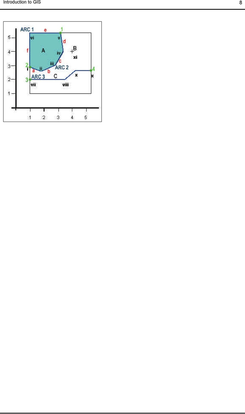
9 Introduction to GIS 9 File 1. Coordinates of nodes and vertex for all the arcs ARC F_node Vertex T_node 1 3.2, 5.2 1, 5.2 1,3 2 1,3 1.8, ,3 3.3,4 3.2, ,2 3.5,2 4.2, ,2.7 File 2. Arcs topology ARC F_node T_node R_poly L_poly External A A External External External File 3. Polygons topology Polygon Arcs A 1, 2 File 4. Nodes topology Node Arcs 1 1,2 2 1, Figure 8. ARC / NODE structure or POLYVRT data bases The elements in a vector based GIS are then the DBMS (Data Base Management System) for the attributes and the system that manages the topological data. In some GIS packages, the DBMS is based in an existing software, i.e. dbase. entity-relation model Three elements are considered in this approach: (a) Entities as the relevant objects for the data base. In a GIS, an entity is any fact that can be localised spatially. (b) Attributes or characteristics attached to the entities. Each attribute has a limited domain of possible values, i.e. the quality of a road can be bad, average, good, very good. (c) Relations or mechanisms that allow to relate entities. Some examples are: located in, contained in, crossed with, etc. DBMS
 for the attributes and the system that manages the topological data.")
10 Introduction to GIS 10 The data bases used in GIS are most commonly relational. Nevertheless, Object Oriented data bases are progressively incorporated. relational data bases In a relational data base, data is stored in tables where rows represent the objects or entities and columns the attributes or variables. A data base is usually composed of several tables and the relations between them is possible through a common identifier that is unique for each entity. Most of the relational data bases in GIS present two variables with identifiers; one of them is unique and correlative, it could be numeric or alphabetic, and the second one might be repeated and helps to organise the attribute table. The advantages of using this kind of data base are: o The design is based in a methodology with heavy theoretical basis, which offers confidence in its capacity to evolve. o It is very easy to implement it, specially in comparison with other models such as hierarchical, network, and object oriented. o It is very flexible. New tables can be appended easily. o Finally, many powerful DBMS using this approach contains query languages (like SQL) which makes easy to include this tool in a GIS. Thus, some commercialised GIS packages include a DBMS pre- existent. object oriented data bases Based on objects, it can be defined as an entity with a localisation represented by values and by a group of operations. Thus, the advantage in comparison with relational data bases is based on the inclusion, in the definition of an object, not only its attributes but also the methods or operations that act on this object. In addition, the objects belong to classes that can have their own variables and these classes can belong to super-classes. Raster based GIS raster representation of data Raster is a method for the storage, processing and display of spatial data. Each area is divided into rows and columns, which form a regular grid structure. Each cell must be rectangular in shape, but not necessarily square. Each cell within this matrix contains location co-ordinates as well as an attribute value. The spatial location of each cell is implicitly contained within the ordering of the matrix, unlike a vector structure which stores topology explicitly. Areas containing the same attribute value are recognised as such, however, raster structures cannot identify the boundaries of such areas as polygons. Raster data is an abstraction of the real world where spatial data is expressed as a matrix of cells or pixels (see figure 9), with spatial position implicit in the ordering of the pixels. With the raster data model, spatial data is not continuous but divided into discrete units. This makes raster data particularly suitable for certain types of spatial operation, for example overlays or area calculations. Raster structures may lead to increased storage in certain situations, since they store each cell in the matrix regardless of whether it is a feature or simply 'empty' space. grid size and resolution A pixel is the contraction of the words picture element. Commonly used in remote sensing to describe each unit in an image. In raster GIS the pixel equivalent is usually referred to as a cell element or grid cell. Pixel/cell refers to the smallest unit of information available in an image or raster map. This is the smallest element of a display device that can be independently assigned attributes such as colour. Pixel size and number of rows and columns: "The size of the pixel must be half of the smallest distance to be represented" Star and Estes (1990) raster data structures exhaustive enumeration

11 Introduction to GIS 11 (figure 9) In this data structure every pixel is given a single value, hence there is no compression when many like values are encountered. run-length encoding (figure 10) This is a raster image compression technique. If a raster contains groups of cells with identical values, run length encoding can compress storage. Instead of storing each cell, each component stores a value and a count of cells with that value. If there is only one cell the storage doubles, but for three or more cells there is a reduction. The longer and more frequent the consecutive values are, the greater the compression that will be achieved. This technique is particularly useful for encoding monochrome images or binary images (Chrisman, 1997). Figure 9. Exhaustive representation

12 Introduction to GIS 12 Figure 10. Run-length encoding advantages/disadvantages of raster and vector data models raster precision in graphics traditional cartography data volume topology computation update continuous space integration discontinuous vector data capture Data capture for raster datasets can include: Remote Sensing Manual digitisation: o Points o Lines o Polygons Automatic digitisation Scanning rasterisation of vector data The process of converting vector data, which is a series of points, lines and polygons, into raster data, which is a series of cells each with a discrete value. This process is essentially easier than the reverse process, which is converting data from raster format to vector format. raster to vector conversion The process of converting an image made up of raster cells into one described by vector data. This may or may not involve the encoding of topology.

13 Introduction to GIS 13 references Berhardsen, T. (1992) Geographic Information Systems. Viak IT/Norwegian Mapping Authority, Arendal, Norway. Berhardsen, T. (1996) Geographic Information Systems. Halsted Press. Bernhardsen, T. (1999) Geographic information systems : an introduction. Wiley, New York. Chrisman, N.R. (1997) Exploring Geographic Information Systems. John Wiley and Sons. demers, M.N. (1997) Fundamentals of Geographic Information Systems. John Wiley and Sons. Huxhold, W.E. (1991) An Introduction to Urban Information Systems. New York, OUP. Laurini, R. and Thompson, D. (1992) Fundamentals of Spatial Information Systems. London, Academy Press. Maguire, D.J., Goodchild, M.F. and Rhind, D.W. (eds.) (1991) Geographical Information Systems: Principles and Applications. Avon, Longman Scientific and Technical. Martin, D. (1991) Geographical Information Systems and their Socioeconomic Applications. London, Routledge. Peuquet, D.J. and Marble, D.F. (eds.) (1990) Introductory Readings in Geographic Information Systems. London, Taylor and Francis. Star, J. and Estes, J. (1990) Geographical Information Systems: An Introduction. Englewoods Cliffs, New Jersey, Prentice Hall.
 Fundamentals of Spatial Information Systems. London, Academy Press. Maguire, D.J., Goodchild, M.F. and Rhind, D.W. (eds.) (1991) Geographical Information Systems: Principles and Applications.")
Introduction to GIS (Basics, Data, Analysis) & Case Studies. 13 th May 2004. Content. What is GIS?
 & Case Studies. 13 th May 2004. Content. What is GIS?") Introduction to GIS (Basics, Data, Analysis) & Case Studies 13 th May 2004 Content Introduction to GIS Data concepts Data input Analysis Applications selected examples What is GIS? Geographic Information
Introduction to GIS (Basics, Data, Analysis) & Case Studies 13 th May 2004 Content Introduction to GIS Data concepts Data input Analysis Applications selected examples What is GIS? Geographic Information
GEOGRAPHIC INFORMATION SYSTEMS CERTIFICATION
 GEOGRAPHIC INFORMATION SYSTEMS CERTIFICATION GIS Syllabus - Version 1.2 January 2007 Copyright AICA-CEPIS 2009 1 Version 1 January 2007 GIS Certification Programme 1. Target The GIS certification is aimed
A GIS helps you answer questions and solve problems by looking at your data in a way that is quickly understood and easily shared.
 A Geographic Information System (GIS) integrates hardware, software, and data for capturing, managing, analyzing, and displaying all forms of geographically referenced information. GIS allows us to view,
Institute of Natural Resources Departament of General Geology and Land use planning Work with a MAPS
 Institute of Natural Resources Departament of General Geology and Land use planning Work with a MAPS Lecturers: Berchuk V.Y. Gutareva N.Y. Contents: 1. Qgis; 2. General information; 3. Qgis desktop; 4.
Implementation Planning
 Implementation Planning presented by: Tim Haithcoat University of Missouri Columbia 1 What is included in a strategic plan? Scale - is this departmental or enterprise-wide? Is this a centralized or distributed
A HYBRID APPROACH FOR AUTOMATED AREA AGGREGATION
 A HYBRID APPROACH FOR AUTOMATED AREA AGGREGATION Zeshen Wang ESRI 380 NewYork Street Redlands CA 92373 Zwang@esri.com ABSTRACT Automated area aggregation, which is widely needed for mapping both natural
SPATIAL ANALYSIS IN GEOGRAPHICAL INFORMATION SYSTEMS. A DATA MODEL ORffiNTED APPROACH
 POSTER SESSIONS 247 SPATIAL ANALYSIS IN GEOGRAPHICAL INFORMATION SYSTEMS. A DATA MODEL ORffiNTED APPROACH Kirsi Artimo Helsinki University of Technology Department of Surveying Otakaari 1.02150 Espoo,
Raster Data Structures
 Raster Data Structures Tessellation of Geographical Space Geographical space can be tessellated into sets of connected discrete units, which completely cover a flat surface. The units can be in any reasonable
What Should a GIS Librarian Do?
 What Should a GIS Librarian Do? Tsering Wangyal Shawa Digital Map and Geospatial Information Center Princeton University Library Shawatw@princeton.edu 609-258-6804 American Library Association Map and
What is GIS? Geographic Information Systems. Introduction to ArcGIS. GIS Maps Contain Layers. What Can You Do With GIS? Layers Can Contain Features
 What is GIS? Geographic Information Systems Introduction to ArcGIS A database system in which the organizing principle is explicitly SPATIAL For CPSC 178 Visualization: Data, Pixels, and Ideas. What Can
Chapter Contents Page No
 Chapter Contents Page No Preface Acknowledgement 1 Basics of Remote Sensing 1 1.1. Introduction 1 1.2. Definition of Remote Sensing 1 1.3. Principles of Remote Sensing 1 1.4. Various Stages in Remote Sensing
DATABASE MANAGEMENT FILES GIS06
 DATABASE MANAGEMENT Last day we looked at spatial data structures for both vector and raster data models. When working with large amounts of data, it is important to have good procedures for managing the
INTRODUCTION TO ARCGIS SOFTWARE
 INTRODUCTION TO ARCGIS SOFTWARE I. History of Software Development a. Developer ESRI - Environmental Systems Research Institute, Inc., in 1969 as a privately held consulting firm that specialized in landuse
APLS 2011. GIS Data: Classification, Potential Misuse, and Practical Limitations
 APLS 2011 GIS Data: Classification, Potential Misuse, and Practical Limitations GIS Data: Classification, Potential Misuse, and Practical Limitations Goals & Objectives Develop an easy to use geospatial
DEVELOPMENT OF A MULTIMEDIA SPATIAL INFORMATION SYSTEM
 DEVELOPMENT OF A MULTIMEDIA SPATIAL INFORMATION SYSTEM Qiming Zhou and Allan H. Evans Lecturers School of Geography, The University of New South Wales PO Box 1, Kensington, NSW 2033, Australia ISPRS Commission
Understanding Raster Data
 Introduction The following document is intended to provide a basic understanding of raster data. Raster data layers (commonly referred to as grids) are the essential data layers used in all tools developed
GEOGRAPHIC INFORMATION SYSTEMS
 GEOGRAPHIC INFORMATION SYSTEMS WHAT IS A GEOGRAPHIC INFORMATION SYSTEM? A geographic information system (GIS) is a computer-based tool for mapping and analyzing spatial data. GIS technology integrates
GIS Databases With focused on ArcSDE
 Linköpings universitet / IDA / Div. for human-centered systems GIS Databases With focused on ArcSDE Imad Abugessaisa g-imaab@ida.liu.se 20071004 1 GIS and SDBMS Geographical data is spatial data whose
The Use of Geographic Information Systems in Risk Assessment
 The Use of Geographic Information Systems in Risk Assessment With Specific Focus on the RiVAMP Methodology Presented by Nadine Brown August 27, 2012 Climate Studies Group Mona Climate Change Workshop Presentation
DATA QUALITY IN GIS TERMINOLGY GIS11
 DATA QUALITY IN GIS When using a GIS to analyse spatial data, there is sometimes a tendency to assume that all data, both locational and attribute, are completely accurate. This of course is never the
GIS 101 - Introduction to Geographic Information Systems Last Revision or Approval Date - 9/8/2011
 Page 1 of 10 GIS 101 - Introduction to Geographic Information Systems Last Revision or Approval Date - 9/8/2011 College of the Canyons SECTION A 1. Division: Mathematics and Science 2. Department: Earth,
WHAT IS GIS - AN INRODUCTION
 WHAT IS GIS - AN INRODUCTION GIS DEFINITION GIS is an acronym for: Geographic Information Systems Geographic This term is used because GIS tend to deal primarily with geographic or spatial features. Information
SESSION 8: GEOGRAPHIC INFORMATION SYSTEMS AND MAP PROJECTIONS
 SESSION 8: GEOGRAPHIC INFORMATION SYSTEMS AND MAP PROJECTIONS KEY CONCEPTS: In this session we will look at: Geographic information systems and Map projections. Content that needs to be covered for examination
Vector storage and access; algorithms in GIS. This is lecture 6
 Vector storage and access; algorithms in GIS This is lecture 6 Vector data storage and access Vectors are built from points, line and areas. (x,y) Surface: (x,y,z) Vector data access Access to vector
Representing Geography
 3 Representing Geography OVERVIEW This chapter introduces the concept of representation, or the construction of a digital model of some aspect of the Earth s surface. The geographic world is extremely
GIS. Digital Humanities Boot Camp Series
 GIS Digital Humanities Boot Camp Series GIS Fundamentals GIS Fundamentals Definition of GIS A geographic information system (GIS) is used to describe and characterize spatial data for the purpose of visualizing
Reading Questions. Lo and Yeung, 2007: 2 19. Schuurman, 2004: Chapter 1. 1. What distinguishes data from information? How are data represented?
 Reading Questions Week two Lo and Yeung, 2007: 2 19. Schuurman, 2004: Chapter 1. 1. What distinguishes data from information? How are data represented? 2. What sort of problems are GIS designed to solve?
Digital Cadastral Maps in Land Information Systems
 LIBER QUARTERLY, ISSN 1435-5205 LIBER 1999. All rights reserved K.G. Saur, Munich. Printed in Germany Digital Cadastral Maps in Land Information Systems by PIOTR CICHOCINSKI ABSTRACT This paper presents
KEY WORDS: Geoinformatics, Geoinformation technique, Remote Sensing, Information technique, Curriculum, Surveyor.
 CURRICULUM OF GEOINFORMATICS INTEGRATION OF REMOTE SENSING AND GEOGRAPHICAL INFORMATION TECHNOLOGY Kirsi VIRRANTAUS*, Henrik HAGGRÉN** Helsinki University of Technology, Finland Department of Surveying
The GIS Primer provides an overview of issues and requirements for implementing and applying geographic information systems technology.
 FRONT PIECE David J. Buckley Corporate GIS Solutions Manager Pacific Meridian Resources, Inc. The GIS Primer provides an overview of issues and requirements for implementing and applying geographic information
Principles and Practices of Data Integration
 Data Integration Data integration is the process of combining data of different themes, content, scale or spatial extent, projections, acquisition methods, formats, schema, or even levels of uncertainty,
BYLINE: Michael F. Goodchild, University of California, Santa Barbara, www.geog.ucsb.edu/~good
 TITLE: GEOGRAPHIC INFORMATION SYSTEM BYLINE: Michael F. Goodchild, University of California, Santa Barbara, www.geog.ucsb.edu/~good SYNONYMS: geospatial information system, spatial information system DEFINITION:
Lecture 3: Models of Spatial Information
 Lecture 3: Models of Spatial Information Introduction In the last lecture we discussed issues of cartography, particularly abstraction of real world objects into points, lines, and areas for use in maps.
ArcGIS Data Models Practical Templates for Implementing GIS Projects
 ArcGIS Data Models Practical Templates for Implementing GIS Projects GIS Database Design According to C.J. Date (1995), database design deals with the logical representation of data in a database. The
A User-Friendly Data Mining System. J. Raul Ramirez, Ph.D. The Ohio State University Center for Mapping raul@cfm.ohio-state.edu
 A User-Friendly Data Mining System J. Raul Ramirez, Ph.D. The Ohio State University Center for Mapping raul@cfm.ohio-state.edu 1. Introduction Image acquisition of the Earth's surface has become a common
Constructing an EA-level Database. for the Census
 Constructing an EA-level Database for the Census Amor Laaribi UN-GGIM Secretariat UN Statistics Division New York 1 Overview Stages in the Geographic Database Development Sources of geographic information
ifp ifp 3.7 Thematic Modeling The Object-Oriented Approach Universität Stuttgart Universität Stuttgart hydrography transport
 transport hydrography fed_hwy state_hwy cnty_hwy river stream lake primary secondary hwy_line hwy_pt hwy_area hdy_line hdy_pt hdy_area Beispiel: GIS-Produkt INTERGRAPH 3.7 Thematic Modeling The Object-Oriented
Laurence W. Carstensen Jr. Department of Geography Virginia Polytechnic Institute and State University Blacksburg, VA U.S.A. 24061
 REGIONAL LAND INFORMATION SYSTEM DEVELOPMENT USING RELATIONAL DATABASES AND GEOGRAPHIC INFORMATION SYSTEMS Laurence W. Carstensen Jr. Department of Geography Virginia Polytechnic Institute and State University
DERIVATION OF THE DATA MODEL
 ARC/INFO: A GEO-RELATIONAL MODEL FOR SPATIAL INFORMATION Scott Morehouse Environmental Systems Research Institute 380 New York Street Redlands CA 92373 ABSTRACT A data model for geographic information
The Structure of Geographic Data
 3 The Structure of Geographic Data Geographic data come from a variety of sources, such as digitized maps, aerial photography, GPS, and field data. Valid geographic data serve as a collective true marker
GEOGRAPHIC INFORMATION SYSTEMS Lecture 20: Adding and Creating Data
 Adding Existing Data Into ArcGIS - there are many different ways to get data into ArcGIS GEOGRAPHIC INFORMATION SYSTEMS Lecture 20: Adding and Creating Data Add Data - normally we use the Add Data button
10. Creating and Maintaining Geographic Databases. Learning objectives. Keywords and concepts. Overview. Definitions
 10. Creating and Maintaining Geographic Databases Geographic Information Systems and Science SECOND EDITION Paul A. Longley, Michael F. Goodchild, David J. Maguire, David W. Rhind 005 John Wiley and Sons,
Geographical Information Systems (GIS) and Economics 1
 and Economics 1") Geographical Information Systems (GIS) and Economics 1 Henry G. Overman (London School of Economics) 5 th January 2006 Abstract: Geographical Information Systems (GIS) are used for inputting, storing,
Geographical Information Systems (GIS) and Economics 1 Henry G. Overman (London School of Economics) 5 th January 2006 Abstract: Geographical Information Systems (GIS) are used for inputting, storing,
User s Guide to ArcView 3.3 for Land Use Planners in Puttalam District
 User s Guide to ArcView 3.3 for Land Use Planners in Puttalam District Dilhari Weragodatenna IUCN Sri Lanka, Country Office Table of Content Page No Introduction...... 1 1. Getting started..... 2 2. Geo-referencing...
Using GIS and Virtual Reality to Manage and Inspect Building Plumbing
 Using GIS and Virtual Reality to Manage and Inspect Building Plumbing Shih, Naai-Jung 1 and Wang, Pin-Hung 2 1 National Taiwan University of Science and Technology, Taipei, Taiwan, R.O.C. 2 Kao Yuan University,
SPATIAL DATA MODELS AND SPATIAL DATA
 SPATIAL DATA MODELS AND SPATIAL DATA STRUCTURES TABLE OF CONTENTS 1 Spatial data models: an introduction... 2 2 Geometric entities... 2 2.1 Problems with the entity definition process...5 3 Spatial data
A Method Using ArcMap to Create a Hydrologically conditioned Digital Elevation Model
 A Method Using ArcMap to Create a Hydrologically conditioned Digital Elevation Model High resolution topography derived from LiDAR data is becoming more readily available. This new data source of topography
Improving Data Mining of Multi-dimension Objects Using a Hybrid Database and Visualization System
 Improving Data Mining of Multi-dimension Objects Using a Hybrid Database and Visualization System Yan Xia, Anthony Tung Shuen Ho School of Electrical and Electronic Engineering Nanyang Technological University,
Vector analysis - introduction Spatial data management operations - Assembling datasets for analysis. Data management operations
 Vector analysis - introduction Spatial data management operations - Assembling datasets for analysis Transform (reproject) Merge Append Clip Dissolve The role of topology in GIS analysis Data management
An Introduction to Open Source Geospatial Tools
 An Introduction to Open Source Geospatial Tools by Tyler Mitchell, author of Web Mapping Illustrated GRSS would like to thank Mr. Mitchell for this tutorial. Geospatial technologies come in many forms,
Assessment of Workforce Demands to Shape GIS&T Education
 Assessment of Workforce Demands to Shape GIS&T Education Gudrun Wallentin, Barbara Hofer, Christoph Traun gudrun.wallentin@sbg.ac.at University of Salzburg, Dept. of Geoinformatics Z_GIS, Austria www.gi-n2k.eu
GIS Data in ArcGIS. Pay Attention to Data!!!
 GIS Data in ArcGIS Pay Attention to Data!!! 1 GIS Data Models Vector Points, lines, polygons, multi-part, multi-patch Composite & secondary features Regions, dynamic segmentation (routes) Raster Grids,
A quick overview of geographic information systems (GIS) Uwe Deichmann, DECRG <udeichmann@worldbank.org>
 Uwe Deichmann, DECRG <udeichmann@worldbank.org>") A quick overview of geographic information systems (GIS) Uwe Deichmann, DECRG Why is GIS important? A very large share of all types of information has a spatial component ( 80
A quick overview of geographic information systems (GIS) Uwe Deichmann, DECRG Why is GIS important? A very large share of all types of information has a spatial component ( 80
Aerial imagery and geographic information systems used in the asbestos removal process in Poland
 Towards Horizon 2020 Lasaponara R., Masini N., Biscione M., Editors EARSeL, 2013 Aerial imagery and geographic information systems used in the asbestos removal process in Małgorzata Krówczyńska 1, Ewa
Digitisation Disposal Policy Toolkit
 Digitisation Disposal Policy Toolkit Glossary of Digitisation Terms August 2014 Department of Science, Information Technology, Innovation and the Arts Document details Security Classification Date of review
Geographic Information System Technician
 Career Service Authority Geographic Information System Technician Page 1 of 5 GENERAL STATEMENT OF CLASS DUTIES Performs standard level paraprofessional work compiling, verifying, maintaining and inputting
Introduction to Geographic Information System course SESREMO Tempus Project. Gabriel Parodi
 WRS - ITC. The Netherlands. Introduction to Geographic Information System course SESREMO Tempus Project. Gabriel Parodi Curricula transfer 2014 INTRODUCTION TO GIS COURSE- SESREMO TEMPUS Table of Contents
GIS: Geographic Information Systems A short introduction
 GIS: Geographic Information Systems A short introduction Outline The Center for Digital Scholarship What is GIS? Data types GIS software and analysis Campus GIS resources Center for Digital Scholarship
CityGML goes to Broadway
 CityGML goes to Broadway Thomas H. Kolbe, Barbara Burger, Berit Cantzler Chair of Geoinformatics thomas.kolbe@tum.de September 11, 2015 Photogrammetric Week 2015, Stuttgart The New York City Open Data
Title 10 DEPARTMENT OF NATURAL RESOURCES Division 35 Land Survey Chapter 1 Cadastral Mapping Standards
 Title 10 DEPARTMENT OF NATURAL RESOURCES Division 35 Land Survey Chapter 1 Cadastral Mapping Standards 10 CSR 35-1.010 Application of Standards PURPOSE: These minimum standards provide the digital mapper
Introduction to Geographic Information Systems. A brief overview of what you need to know before learning How to use any GIS software packages
 Introduction to Geographic Information Systems A brief overview of what you need to know before learning How to use any GIS software packages 1 What is GIS? More than map-making software GIS is a system
Digital Terrain Model Grid Width 10 m DGM10
 Digital Terrain Model Grid Width 10 m Status of documentation: 23.02.2015 Seite 1 Contents page 1 Overview of dataset 3 2 Description of the dataset contents 4 3 Data volume 4 4 Description of the data
Mapping Mashup/Data Integration Development Resources Teaching with Google Earth and Google Ocean Stone Lab August 13, 2010
 Mapping Mashup/Data Integration Development Resources Teaching with Google Earth and Google Ocean Stone Lab August 13, 2010 David Hart GIS Specialist University of Wisconsin Sea Grant Institute Virtual
Data access and management
 B Data access and management CONTENTS B.1 Introduction... B-1 B.2 Data requirements and availability... B-1 B.3 Data access... B-2 B.4 Overall procedures... B-2 B.5 Data tools and management... B-4 Appendix
Lesson 15 - Fill Cells Plugin
 15.1 Lesson 15 - Fill Cells Plugin This lesson presents the functionalities of the Fill Cells plugin. Fill Cells plugin allows the calculation of attribute values of tables associated with cell type layers.
Data Storage 3.1. Foundations of Computer Science Cengage Learning
 3 Data Storage 3.1 Foundations of Computer Science Cengage Learning Objectives After studying this chapter, the student should be able to: List five different data types used in a computer. Describe how
Geographic Information Systems
 Jan Coyne, William C. Bell, Mary Maureen Brown, Chad Rupert, and James Nolan Geographic Information Systems A geographic information system (GIS) combines database management and analysis functions with
WP 6 User interface design and implementation. Deliverable 30. GIS query interface specification
 A BIODIVERSITY COLLECTION ACCESS SERVICE FOR EUROPE WP 6 User interface design and implementation Deliverable 30 GIS query interface specification Angel Anta Anna Gadré Bernard Lepen Régine Vignes Lebbe
REGIONAL SEDIMENT MANAGEMENT: A GIS APPROACH TO SPATIAL DATA ANALYSIS. Lynn Copeland Hardegree, Jennifer M. Wozencraft 1, Rose Dopsovic 2 INTRODUCTION
 REGIONAL SEDIMENT MANAGEMENT: A GIS APPROACH TO SPATIAL DATA ANALYSIS Lynn Copeland Hardegree, Jennifer M. Wozencraft 1, Rose Dopsovic 2 ABSTRACT: Regional sediment management (RSM) requires the capability
GIS Data Conversion. GIS maps are digital not analog. Getting the Map into the Computer
 Getting the Map into the Computer Getting the Map into the Computer Getting Started with Geographic Information Systems Chapter 4 4.1 Analog-to-Digital Maps 4.2 Finding Existing Map Data 4.3 Digitizing
Database Management Systems and GIS Design
 Database Management Systems and GIS Design Overview This presentation deals with the relationship between database processing requirements, database management systems, and GIS database design theory.
WATER INTERACTIONS WITH ENERGY, ENVIRONMENT AND FOOD & AGRICULTURE Vol. II Spatial Data Handling and GIS - Atkinson, P.M.
 SPATIAL DATA HANDLING AND GIS Atkinson, P.M. School of Geography, University of Southampton, UK Keywords: data models, data transformation, GIS cycle, sampling, GIS functionality Contents 1. Background
Oracle8i Spatial: Experiences with Extensible Databases
 Oracle8i Spatial: Experiences with Extensible Databases Siva Ravada and Jayant Sharma Spatial Products Division Oracle Corporation One Oracle Drive Nashua NH-03062 {sravada,jsharma}@us.oracle.com 1 Introduction
Basics on Geodatabases
 Basics on Geodatabases 1 GIS Data Management 2 File and Folder System A storage system which uses the default file and folder structure found in operating systems. Uses the non-db formats we mentioned
3D Model of the City Using LiDAR and Visualization of Flood in Three-Dimension
 3D Model of the City Using LiDAR and Visualization of Flood in Three-Dimension R.Queen Suraajini, Department of Civil Engineering, College of Engineering Guindy, Anna University, India, suraa12@gmail.com
PART 1. Representations of atmospheric phenomena
 PART 1 Representations of atmospheric phenomena Atmospheric data meet all of the criteria for big data : they are large (high volume), generated or captured frequently (high velocity), and represent a
DEVELOPMENT OF THE PLANETARY CARTOGRAPHY WEB-SITE WITH OPEN SOURCE CONTENT MANAGEMENT SYSTEM
 CO-131 DEVELOPMENT OF THE PLANETARY CARTOGRAPHY WEB-SITE WITH OPEN SOURCE CONTENT MANAGEMENT SYSTEM ROZHNEV I. Moscow State University of Geodesy and Cartography, PUSHKINO, RUSSIAN FEDERATION Considerable
Design and Implementation of Double Cube Data Model for Geographical Information System
 The International Arab Journal of Information Technology, Vol. 1, No. 2, July 2004 215 Design and Implementation of Double Cube Data Model for Geographical Information System Mohd Shafry Mohd Rahim, Daut
Data Modeling Basics. John Auel GIS Technician II United Services Group
 Data Modeling Basics John Auel GIS Technician II United Services Group Background Bachelor of Science at University of Wisconsin, Steven s Point Area of Emphasis -- Cartography Been at United Services
DATA VISUALIZATION GABRIEL PARODI STUDY MATERIAL: PRINCIPLES OF GEOGRAPHIC INFORMATION SYSTEMS AN INTRODUCTORY TEXTBOOK CHAPTER 7
 DATA VISUALIZATION GABRIEL PARODI STUDY MATERIAL: PRINCIPLES OF GEOGRAPHIC INFORMATION SYSTEMS AN INTRODUCTORY TEXTBOOK CHAPTER 7 Contents GIS and maps The visualization process Visualization and strategies
APPLY EXCEL VBA TO TERRAIN VISUALIZATION
 APPLY EXCEL VBA TO TERRAIN VISUALIZATION 1 2 Chih-Chung Lin( ), Yen-Ling Lin ( ) 1 Secretariat, National Changhua University of Education. General Education Center, Chienkuo Technology University 2 Dept.
GIS Spatial Data Standards
 GIS Spatial Data Standards Manatee County, FL GIS Section, Information Services Department TABLE OF CONTENTS I. Introduction 2 A. Purpose 2 B. Reference 2 II. Spatial Reference Information 2 A. Projection:
Create a folder on your network drive called DEM. This is where data for the first part of this lesson will be stored.
 In this lesson you will create a Digital Elevation Model (DEM). A DEM is a gridded array of elevations. In its raw form it is an ASCII, or text, file. First, you will interpolate elevations on a topographic
Compiled from ESRI s Web site: http://www.esri.com. 1. What Is a GIS?
 Compiled from ESRI s Web site: http://www.esri.com 1. What Is a GIS? A geographic information system (GIS) is a computer-based tool for mapping and analysing things that exist and events that happen on
Spatial data quality assessment in GIS
 Recent Advances in Geodesy and Geomatics Engineering Spatial data quality assessment in GIS DANIELA CRISTIANA DOCAN Surveying and Cadastre Department Technical University of Civil Engineering Bucharest
Application of GIS Analyzes with Cloud Computing
 ion of GIS Analyzes with Cloud Computing Sevket BEDIROGLU, Volkan YILDIRIM and Selcuk ERBAS (Turkey) Key words: GIS, Cloud Computing, Spatial Cloud Computing SUMMARY Usage of Cloud Computing (CC) has been
DATA QUALITY AND SCALE IN CONTEXT OF EUROPEAN SPATIAL DATA HARMONISATION
 DATA QUALITY AND SCALE IN CONTEXT OF EUROPEAN SPATIAL DATA HARMONISATION Katalin Tóth, Vanda Nunes de Lima European Commission Joint Research Centre, Ispra, Italy ABSTRACT The proposal for the INSPIRE
USING SELF-ORGANIZING MAPS FOR INFORMATION VISUALIZATION AND KNOWLEDGE DISCOVERY IN COMPLEX GEOSPATIAL DATASETS
 USING SELF-ORGANIZING MAPS FOR INFORMATION VISUALIZATION AND KNOWLEDGE DISCOVERY IN COMPLEX GEOSPATIAL DATASETS Koua, E.L. International Institute for Geo-Information Science and Earth Observation (ITC).
The UCC-21 cognitive skills that are listed above will be met via the following objectives.
 Master Syllabus Department of Geography GEOG 265: Introduction to Geographic Information Systems Course Description Fundamentals of geographic information systems (GIS). How to visualize geographic information
Pinky Wassenberg, Dean, College of Public Affairs and Administration CPAA College Curriculum Committee
 To: Pinky Wassenberg, Dean, College of Public Affairs and Administration CPAA College Curriculum Committee From: Dennis R. Ruez, Jr., Chair, Department of Environmental Studies Date: 28 January 2011 Re:
AUTOMATION OF FLOOD HAZARD MAPPING BY THE FEDERAL EMERGENCY MANAGEMENT AGENCY ABSTRACT INTRODUCTION
 AUTOMATION OF FLOOD HAZARD MAPPING BY THE FEDERAL EMERGENCY MANAGEMENT AGENCY Daniel M. Cotter Federal Emergency Management Agency Federal Insurance Administration Office of Risk Assessment 500 C Street,
INDIVIDUAL COURSE DETAILS
 INDIVIDUAL COURSE DETAILS A. Name of Institution NATIONAL INSTITUTE OF TECHNICAL TEACHERS TRAINING AND RESEARCH TARAMANI CHENNAI 600 113 [An Autonomous Institute under Ministry of Human Resource Development,
Introduction to GIS. http://libguides.mit.edu/gis
 Introduction to GIS http://libguides.mit.edu/gis 1 Overview What is GIS? Types of Data and Projections What can I do with GIS? Data Sources and Formats Software Data Management Tips 2 What is GIS? 3 Characteristics
Development of 3D Cadastre System to Monitor Land Value and Capacity of Zoning (Case study: Tehran)
") 8 th International Congress on Advances in Civil Engineering, 15-17 September 2008 Eastern Mediterranean University, Famagusta, North Cyprus Development of 3D Cadastre System to Monitor Land Value and
8 th International Congress on Advances in Civil Engineering, 15-17 September 2008 Eastern Mediterranean University, Famagusta, North Cyprus Development of 3D Cadastre System to Monitor Land Value and
Geocoding in Law Enforcement Final Report
 Geocoding in Law Enforcement Final Report Geocoding in Law Enforcement Final Report Prepared by: The Crime Mapping Laboratory Police Foundation August 2000 Report to the Office of Community Oriented Policing
GIS Data Quality and Evaluation. Tomislav Sapic GIS Technologist Faculty of Natural Resources Management Lakehead University
 GIS Data Quality and Evaluation Tomislav Sapic GIS Technologist Faculty of Natural Resources Management Lakehead University The quality of GIS data gains in importance when considering some of the main
Implementing GIS in Optical Fiber. Communication
 KING FAHD UNIVERSITY OF PETROLEUM AND MINERALS COLLEGE OF ENVIRONMENTAL DESIGN CITY & RIGINAL PLANNING DEPARTMENT TERM ROJECT Implementing GIS in Optical Fiber Communication By Ahmed Saeed Bagazi ID# 201102590
Guidelines on Information Deliverables for Research Projects in Grand Canyon National Park
 INTRODUCTION Science is playing an increasing role in guiding National Park Service (NPS) management activities. The NPS is charged with protecting and maintaining data and associated information that
INTELLIGENCE BASED CADASTRAL DATABASE SELECTION AND VISUALIZATION SYSTEM: CONCEPTS AND PROTOTYPE
 INTELLIGENCE BASED CADASTRAL DATABASE SELECTION AND VISUALIZATION SYSTEM: CONCEPTS AND PROTOTYPE Abdullah Hisam Omar and Amran Bachok Department of Geomatic Engineering Faculty of Geoinformation Science
Continuous Spatial Data Warehousing
 Continuous Spatial Data Warehousing Taher Omran Ahmed Faculty of Science Aljabal Algharby University Azzentan - Libya Taher.ahmed@insa-lyon.fr Abstract Decision support systems are usually based on multidimensional