Ministry of Lands, Parks and Housing Parks and Outdoor Recreation Division South Coast Region BRIDAL VEIL FALLS PARK MASTER PLAN
|
|
|
- Harold Hicks
- 8 years ago
- Views:
Transcription
1 Ministry of Lands, Parks and Housing Parks and Outdoor Recreation Division South Coast Region BRIDAL VEIL FALLS PARK MASTER PLAN February, 1984

2 To: Mr. C. J. Velay SOUTH COAST REGION Director, Park Programs Branch Date: Parks & Outdoor Recreation Division File: Ministry of Lands, Parks & Housing Victoria, B. C. This Master Plan for Bridal Veil Falls Provincial Park is herewith submitted for consideration and approval. Approved: George Trachuk Regional Director, South Coast Region Approved: Director, Park Programs Branch Approved: Executive Director

3 TABLE OF CONTENTS PART I: SUMMARY AND BACKGROUND Page A. Plan Summary...1 B. Regional and Provincial Context...3 C. Resources Natural Resources...4 a) Natural Regions/Regional Landscapes b) Climate c) Physiography d) Hydrology e) Vegetation f) Wildlife 2. Cultural Resources...5 a) Archaeological b) Historical 3. Visual Resources Analysis...6 a) Conservation b) Recreation D. Land Tenures, Occupancy Rights and Jurisdictions Leases and Use Permits 2. Fee Simple Lands 3. Other Tenures a) Trans Mountain Pipeline 4. Trespasses 5. Mineral Claims 6. Statutory Jurisdictions a) Hunting Regulations b) Water Rights 7. Major Additions E. Existing Facilities...7 F. Market Analysis Existing Use 2. Supply 3. Demand 4. Conclusions G. Planning Issues...11
 Hunting Regulations b) Water Rights 7. Major Additions E. Existing Facilities...7 F. Market Analysis...9 1. Existing Use 2. Supply 3.")
4 PART II: THE PLAN A. Specific Objectives...12 B. Zoning Development Zone 2. Natural Area Zone C. Development Bridal Veil Falls Trail Extension 2. Group Picnicking in Grass Area D. Management Policies Resources 2. Public Use E. Marketing and Information Program...17 Page Appendix a) Visitor Attendance: b) Ministry of Highways Summer Traffic Volumes: Bibliography...19
 Visitor Attendance: 1979-1982.")
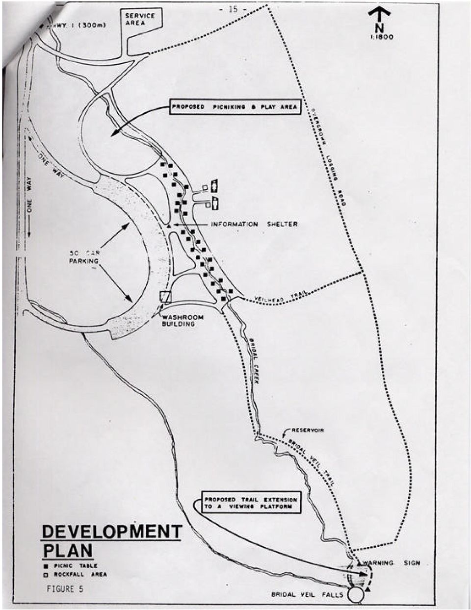
5 LIST OF FIGURES AND TABLE Page FIGURE 1: FIGURE 2: Area Map...2 Area Tourist Facilities...3 FIGURE 3: Site Plan...8 FIGURE 4: FIGURE 5: Zoning...13 Development Plan...15 TABLE 1: Suppliers and Supply of Recreation Related Services in the Area...10

6 - 1 - PART I: SUMMARY AND BACKGROUND A. Plan Summary Bridal Veil Falls Provincial Park provides a natural and scenic day use area to the motoring public and fulfills a recreation role by offering park visitors a view of Bridal Veil Falls. This small park, located off the Trans Canada Highway east of Chilliwack, lies adjacent to numerous private sector tourist attractions. As such, the park contributes significantly to promoting tourism and recreation opportunities along this linear corridor. Present day use activities include picnicking, hiking and viewing the falls. The trail to the falls is a 20 minute walk from the parking lot, offering easy hiking and nature study opportunities for the majority of visitors. The abundance of tourist amenities along Highway #1 between Hope and Chilliwack highlights the area as a major tourist destination location. This high use, with over 100,000 visitors annually, warrants continued operation of the park and only minor changes to the present management policies. Increased low-maintenance services and trail upgrading for the day use public will be implemented.

7

8 - 3 - B. Regional and Provincial Context Bridal Veil Falls Provincial Park was established in 1965 as a Class 'A', Category 3 park. This 32 hectare park is located in the Fraser River Valley, 16 kilometres east of Chilliwack and directly accessible from Highway #1(Figure 1). The park has long served a rest stop function due to its location relative to Highway #1 and points east and west. It is a one and one-half hour drive from Vancouver, and is therefore an important location for a rest stop. In the immediate vicinity of the park there are a number of tourist attractions (Figure 2) that provide a variety of activities to visitors including ornamental gardens, water slides and other types of amusement park opportunities.

9 - 4 - C. Resources 1. Natural Resources a) Natural Regions/Regional Landscapes The park is located within the Coastal Mountain Natural Region and within the Lower Mainland-Skagit Mountains Regional Landscape. This landscape is characterized by low elevation valleys, heavily forested, rounded mountains, and a wet climate. b) Climate The climate in the park, as recorded from the Laidlaw Weather Station (20 kilometres east of Bridal Veil Falls Park) is a modified coastal climate with comparatively cool winters and warm summers. The mean temperature range for the months May through September is 12 Celsius to 18 Celsuis, with the maximum temperature occurring in August. The mean temperature range for the months December through March is -1.2 Celsius to 7 Celsius, with the minimum temperature occurring in January. The months from October through to March produce the highest levels of rainfall, with a mean range of 126 centimetres to 361 centimetres. Snow comprises a small portion of the precipitation during the colder segments of December and January. However, under normal conditions, the low levels and poor quality of the snow do not present an opportunity for winter recreation activities. Bridal Veil Falls is prone to freezing during colder winters, which results in the formation of an unstable wall of ice. Although this creates a scenic viewing experience, the base of the falls becomes an extremely hazardous area. c) Physiography The falls are more closely associated with the Skagit Range of the Cascade Mountains, while the remainder of the park area represents a combination of an ancient floodplain (Fraser River Floodplain) and glacial processes. The major portion of the use area within the park is located on moderately sloped ground (under 10%), while the terrain closer to the falls becomes excessively sloped. The base of the falls is situated at an elevation of 200 metres and rises 50 to 60 metres to the top of the falls. The rock outcropping at the falls shows evidence of intense fracturing resulting in periodic rock falls, with the surrounding soils being of a podzolic type.
 Climate The climate in the park, as recorded from the Laidlaw Weather Station (20 kilometres east of Bridal Veil Falls Park) is a modified coastal climate with comparatively cool winters and warm")
10 - 5 - d) Hydrology Bridal Veil Falls is the major attraction/feature of the park. Water from Bridal Creek falls 50 to 60 metres and dilates 10 metres over a smoothed rock face, creating the "veil-like" effect of the falls. Bridal Creek extends for 1.8 kilometres, with a width of between one half to one metre. During drier summer months, the volume of water flowing over the falls may decrease significantly, thus reducing the visual quality of the falls. Bridal Creek is non-supportive of fish. e) Vegetation The park is situated in the Coastal Western Hemlock biogeoclimatic zone (Krajina, 1969). The major tree types found in the park include Western Red Cedar (Thuja plicata), Western Hemlock (Tsuga heterophylla), Broadleaf Maple (Acer macrophyllum), and Red Alder (Alnus rubra). The understory is dominated by ferns of which the Western Sword Fern (Polystichum munitum) and the Spiny Wood Ferns (Dryopterus austriaca ) show prominence. Other major vegetation types of the understory include Devil's Club (Oplopanax horridus), Twisted Stalk (Streptopus amplexifolius), Meadow Rue (Thalictrum occidentale), Youth-on-Age (Tolmlea menziesii). Wild Rose (Rosa, spp.). Waxberry (Symphoricarpos a1bus), and Parsley Fern (Cryptogramma acrostichoides). The trees are spaced far apart, and the understory is sparse and low lying. Although this gives a spacious appearance within the trail areas, the canopy is quite dense and results in a shaded trail. The mixed vegetation cover is composed of 60% coniferous and 40% deciduous. f) Wildlife The significant wildlife species of Bridal Veil Falls Park are primarily songbirds and small mammals. Songbird species include the varied thrush, black-throated gray warbler, red breasted nuthatch and many more. The small area and low resource diversity of the park are not conducive to a major wildlife presence, however species which have been known to range within the park include porcupine, Columbia blacktail deer and black bears. 2. Cultural Resources a) Archaeological There are no archaeological sites within Bridal Veil Falls Provincial Park.

11 - 6 b) Historical The historical significance of Bridal Veil Falls Park is related to the village of Popkum, which has settlement records dating back to the 1700s. Popkum is an Indian word (Pop-kum) meaning "puff ball", which grows in the area in profusion. In the early 1900s, the Ennis homestead was sold to skipper Warnebolt, who proceeded to build the Bridal Falls Chalet. To facilitate the power requirements of the chalet and its heated swimming pool, Bridal Veil Falls was used to generate electricity. Today, however, only traces of the concrete foundation for the power generator can be found. 3. Visual Resources Bridal Veil Falls is the major viewing experience of the park. The quality of the present viewing location is hampered by trees and its distance from the falls. As well, the dense canopy of the forest results in a heavily shaded viewing area, which puts constraints on photography. The picnicking area is surrounded by dense vegetation which creates a pleasant natural environment and acts as a buffer to the development along Highway #1. This natural woodland setting is focal for visitors during their brief stopovers. 4. Analysis a) Conservation Bridal Veil Falls is a feature of scenic value, both to local residents and highway travellers. Its value is enhanced by the park's proximity to Highway #1. b) Recreation The location and features of the park make it suited to picnicking, walking and viewing opportunities in association with a major highway and a commercial tourist node.

12 - 7 D. Land Tenures. Occupancy Rights and Jurisdictions 1. Leases and Use Permits: None. 2. Fee Simple Lands: None. 3. Other Tenures: (See Figure 4) a) `Trans Mountain Pipeline Right-of-Way: Plan 13034, No C 4. Trespasses: None. 5. Mineral Claims: None. 6. Statutory Jurisdictions: a Hunting Regulations: The discharge of firearms is prohibited within the park boundaries b) Water Rights: F.W.L Gulf Oil of Canada F.W.L Parks Branch (substitiution of C.W.L ) 7. Major Additions: None. E. Existing Facilities Existing park facilities (Figure 3) include: 1. Paved, 50 car capacity parking lot. 2. A four-unit washroom building adjacent to the parking area. 3. One set of pit toilets and a park information shelter. 4. Eighteen Type II picnic tables. 5. Reservoir with tap facilities servicing the picnic area and washroom building. 6. Warning sign at end of Bridal Veil Trail.
 7. Major Additions: None. E. Existing Facilities Existing park facilities (Figure 3) include: 1. Paved, 50 car capacity parking lot. 2.")
13

14 - 9 - F. Market Analysis 1. Existing Use The majority of the visitors to Bridal Veil Falls Park are highway travellers heading to other destinations who stop for a rest or a picnic/viewing experience. However, the park also serves as a destination picnic site for the local/regio nal area residents, mainly from the Chilliwack area. Although there is no visitor origin data for this park, other references (N icolum River Park) suggest that visitors to the area are mainly residents from the Interior and Lower Mainland Regions. The attendance figures (appended) from Bridal Veil Falls Park indicate an average of over 100,000 visitors (31,000 visitor parties) per year, with 80% of these visiting between May and September. The market area that Bridal Veil Falls Park serves is the Chilliwack area, with Highway #1 being the major source. Since the park does not supply campsite accommodation, there is no market competition with the private campgrounds in the vicinity. Occasionally, campers have been found using the parking lot on an overnight basis, however this is not a permitted use of the park facilities. During the summer weekend periods, the parking and picnicking facilities meet or exceed the park s capacity over 60 of the time. 2. Supply The following chart (Table 1) identifies the supplier and supply of park and outdoor recreation related services in the area. 3. Demand Bridal Veil Falls Park offers services which are complementary to those offered by Bridal Falls Camperland and other private campgrounds. There is a variety of recreational opportunities available throughout the area, which enhances the demand-use. The general demand for Bridal Veil Falls Park may be assessed according to highway traffic volumes and park attendance records. As the park is generally oriented to highway users, the intensity of traffic volumes has a direct relationship on park demand. Ministry of Highways data for Highway #1 (appended) indicates that summer traffic volumes are increasing by 3-5% per year. This suggests an increased demand for park services, however at present, there is no excessive demand on the park facilities and the parking lot capacity is adequate for the majority of the time. As such, there is no indication that the present level of use is exceeding the park's carrying capacity and future demand increase will be easily absorbed. 4. Conclusions The day use opportunities are major viable services of high demand in the market. The park is oriented to the highway use and demand will grow in direct relation to traffic volumes.
 from Bridal Veil Falls Park indicate an average of over 100,000 visitors (31,000 visitor parties) per year, with 80% of these visiting between May and September.")
15

16 G. Planning Issues 1. The opportunity to view Bridal Veil Falls should be enhanced, made safer and made more accessible. The present poor quality of the viewing opportunity encourages the public to traverse a hazardous area for a better view, in spite of the existing warning sign. A proposed trail extension would guide the public around the hazard area to the base of the falls where a viewing platform would be constructed. Warning sign location near base of falls PHOTO NOT AVAILABLE

17 PART II: THE PLAN A. Specific Objectives The general purposes of the park are to provide a rest stop facility along Highway #1, with day use opportunities, and the preservation of Bridal Veil Falls through the following objectives: * To conserve and present Bridal Veil Falls as a scenic feature of recreation interest. * To provide picnicking, walking and viewing opportunities in a scenic, woodland setting to both highway travellers and local residents * To provide information about the features of Bridal Veil Falls Park. B. Zoning Bridal Veil Falls Provincial Park is divided into two management areas: development zone and natural environment zone (Figure 4). 1. Development Zone The purpose of the development zone is to provide a variety of facility oriented recreational opportunities. All the day use areas of the park are therefore included in this zone. 2. Natural Environment Zone The purpose of the natural environment zone is to ensure that management actions will maintain or restore if required the natural environment setting of the park. This addresses the park objectives of conserving and preserving the remaining park land.

18

19 C. Development (Figure 5) Although the park is presently developed, some future enhancement projects are appropriate in consideration of the objectives for the park. 1. Bridal Veil Falls Trail Extension The proposed trail extension would be less than 100 metres in length, however the terrain it follows is very steep (20-30%). Therefore, to facilitate access, steps and hand rails will need to be incorporated for roughly one-third of the trail extension in areas of excessively steep terrain, with a viewing platform constructed at the end of the trail. As the majority of the trail users are casual hikers, families and older people, it is recommended that the trail extension be constructed with a high safety factor and easy accessibility. Trail construction may be developed through federal and provincial employment programs. 2. Group Picnicking in Grass Area The grass area is becoming increasingly popular for group picnicking which, in future, may result in a need for the addition of picnic tables and a small play area. By developing a multi-use site plan, a conflict with other types of recreational use in this area will be minimized. D. Management Policies Bridal Veil Falls Provincial Park lies within the Manning Zone of the Fraser Valley District. Its small area, coupled with the limited diversity of resources and good design layout, have made it a relatively simple park to manage. There are very few actions required to manage the natural resources and public uses of the park. 1. Resources a) Land The land will be managed for intense levels of recreational use. All paths and surfaces will be maintained and improved as required and the existing balance of natural and developed areas will be retained. b) Water Management of Bridal Creek will be limited to: i) directing the flow of water such that the trails are not affected; ii) the maintenance of the reinforced creek banks.

20
21 Bridal Veil Falls from the present trail viewing location PHOTO NOT AVAILABLE Popular group picnicking and recreation area PHOTO NOT AVAILABLE
22 c) Vegetation Trees are being monitored on a continual basis for any hazards that may affect public safety and corrective action will be taken as required. Some smaller trees will be trimmed or eliminated to decrease the shading effect at the picnic sites and improve the viewing of Bridal Veil Falls. d) Wildlife Existing wildlife species and habitat will be retained at present levels as much as possible. e) Cultural The historical significance of Bridal Veil Falls as it relates to Popkum will be explained on the existing information shelter. f) Visual 2. Public Use The visual quality of the park will be upgraded in the falls area, while the rest of the park will be maintained in its existing condition. a) Recreation The acceptable types of recreational activity for this park include picnicking, hiking and viewing. b) Education The existing visitor services material provided on the information shelter will be expanded to include a trail map of the park and a guide to the interpretation displays. The information will be updated periodically. E. Marketing and Information Program Marketing of Bridal Veil Falls Provincial Park is through the standard provincial parks map, park brochure and staff referral. Further promotion of the park other than for the early and late summer may encourage levels of use too intense for the park's carrying capacity. As such, no further marketing action is recommended.
23 APPENDIX VISITOR ATTENDANCE FOR BRIDAL VEIL FALLS PROVINCIAL PARK YEAR MAY JUNE JULY AUG. SEPT. TOTAL (ANNUAL) , , , ,722 MINISTRY OF HIGHWAYS SUMMER TRAFFIC VOLUMES ROUTE NUMBER 1, STATION NO , E & W KILOMETRES EAST OF ROUTE 9 YEAR: ,000 12,800 9,900 11,200 11,600 12, ,900
24 BIBLIOGRAPHY Ministry of Environment, "Laidlaw Weather Station Data." Ministry of Transportation and Highways, "Summer Traffic Volumes on Provincial Highways in British Columbia " Ministry of Transportation and Highways, "Summer Traffic Volumes on Provincial Highways in British Columbia " Parks and Outdoor Recreation Division, "Recreation Reserve Assessment Report." Unpublished Government Report. Parks and Outdoor Recreation Division, "Park Data Handbook." Unpublished Government Manual. Parks and Outdoor Recreation Division, "Nicolum River Master Plan." Unpublished Government Report.
COQUIHALLA CANYON RECREATION AREA MASTER PLAN
 COQUIHALLA CANYON RECREATION AREA MASTER PLAN COQUIHALLA CANYON RECREATION AREA MASTER PLAN JULY, 1987 George Trachuk Regional Director South Coast Region M. H. Turner Planning Manager South Coast Region
Ministry of Lands, Parks and Housing Parks and Outdoor Recreation Division South Coast Region EMORY CREEK PROVINCIAL PARK MASTER PLAN
 Ministry of Lands, Parks and Housing Parks and Outdoor Recreation Division South Coast Region EMORY CREEK PROVINCIAL PARK MASTER PLAN July, 1984 TABLE OF CONTENTS PART I: SUMMARY AND BACKGROUND A. Plan
Revising the Nantahala and Pisgah Land Management Plan Preliminary Need to Change the Existing Land Management Plan
 Revising the Nantahala and Pisgah Land Management Plan Preliminary Need to Change the Existing Land Management Plan Throughout the Plan 1. There is a fundamental need for the revised plan to address how
Marchand Provincial Park. Draft Management Plan
 Marchand Provincial Park Draft Management Plan Marchand Provincial Park Draft Management Plan Table of Contents 1. Introduction... 3 2. Park History... 3 3. Park Attributes... 4 3.1 Natural... 4 3.2 Recreational...
APPENDIX B: TRAIL DEVELOPMENT AND MANAGEMENT STANDARDS
 APPENDIX B: TRAIL DEVELOPMENT AND MANAGEMENT STANDARDS This section provides guidance on a variety of trail issues for planners and developers of the Ice Age NST across the state. It also provides introductory
NEZ PERCE-CLEARWATER FORESTS
 United States Department of Agriculture Forest Service NEZ PERCE-CLEARWATER FORESTS Fish Creek Meadows A Year-Round Playground For Idaho and the Northwest Fish Creek Meadows Year-round Recreation For Everyone
SANTA BARBARA COUNTY COMPREHENSIVE PLAN LOMPOC AREA
 SANTA BARBARA COUNTY COMPREHENSIVE PLAN LOMPOC AREA A. LAND USE ELEMENT INTERPRETIVE GUIDELINES B. COMMUNITY BENEFITS C. COUNTY ACTION ITEMS Adopted by the Board of Supervisors November 9, 1999 A. Santa
MAQUINNA PROVINCIAL PARK
 MAQUINNA PROVINCIAL PARK PURPOSE STATEMENT AND ZONING PLAN February 2003 MAQUINNA PROVINCIAL PARK Purpose Statement and Zoning Plan Primary Role The primary role of Maquinna Provincial Park is to protect
Klingle Valley Trail - Public Meeting. January 16, 2014 @ 6:00 pm Cleveland Park Library
 Klingle Valley Trail - Public Meeting January 16, 2014 @ 6:00 pm Cleveland Park Library 1 Tonight s Meeting Objective To provide project updates. To provide an overview of the project. To provide specifics
GORDON BAY PROVINCIAL PARK MASTER PLAN
 GORDON BAY PROVINCIAL PARK MASTER PLAN November, 1995 Southern Vancouver Island District i GORDON BAY PROVINCIAL PARK MASTER PLAN November, 1995 ii iii TABLE OF CONTENTS PLAN HIGHLIGHTS...-i- Section One:
Corridor Goals and Objectives
 Corridor Goals and Objectives This chapter presents the goals and objectives, developed by the Corridor Study Committee, that serve as the purpose and intent of the Corridor Plan. This plan covers a twenty
Welcome to the future of Terwillegar Park a Unique Natural Park
 Welcome to the future of Terwillegar Park a Unique Natural Park 1 Introduction The Terwillegar Park Concept Plan study will develop an overall concept plan, management objectives and development guidelines
Reimaging Nevada s Traveler Experience. Welcome Stations Rest Areas Rest Stops
 Reimaging Nevada s Traveler Experience Welcome Stations Rest Areas Rest Stops Introduction Nevada is known world-wide as a vibrant, diverse and appealing tourism destination, economic development innovator
LOW LEVEL ROAD RE-ALIGNMENT PACIFIC YEW TREE ASSESSMENT ENKON File No. 1590-001
 April 11, 2012 Port Metro Vancouver 100 The Pointe, 999 Canada Place Vancouver, BC V6C 3T4 Attention: RE: Carolina Eliasson, Environmental Specialist LOW LEVEL ROAD RE-ALIGNMENT PACIFIC YEW TREE ASSESSMENT
APPENDIX F RIGHTS-OF-WAY PRESERVATION GUIDELINES
 Los Angeles County Metropolitan Transportation Authority (Metro) 2009 Transportation Improvement Program Call for Projects APPENDIX F RIGHTS-OF-WAY PRESERVATION GUIDELINES Los Angeles County Metropolitan
4.2 Buena Vista Creek Watershed
 Buena Vista Creek Watershed 4.2 Buena Vista Creek Watershed Watershed Overview The Buena Vista Creek Watershed is the fourth-largest system within the Carlsbad Hydrologic Unit. The watershed extends approximately
MANAGEMENT DIRECTION STATEMENT May, 1999
 Kootenay District AAGEET DIRECTIO STATEET ay, 1999 for Akamina-Kishenina Provincial Park inistry of Environment Lands and Parks BC Parks Division Table of Contents I. Introduction A. Setting and Context...1
Appendix I: Recreation and Visitor Services Market Analysis for the Kobuk-Seward Peninsula Planning Area
 Appendix I: Recreation and Visitor Services Market Analysis for the Kobuk-Seward Peninsula Planning Area A. Introduction...I-3 B. Salmon Lake/Kigluaik SRMA (Alternatives C and D)...I-4 C. Squirrel River
Department of State Development, Infrastructure and Planning. State Planning Policy state interest guideline. State transport infrastructure
 Department of State Development, Infrastructure and Planning State Planning Policy state interest guideline State transport infrastructure July 2014 Great state. Great opportunity. Preface Using this state
PUBLIC INFORMATIONAL MEETING THURSDAY APRIL 30, 2015
 PUBLIC INFORMATIONAL MEETING THURSDAY APRIL 30, 2015 AT ACTON TOWN HALL FAULKNER ROOM 472 MAIN STREET ACTON, MASSACHUSETTS 7:00 PM FOR THE PROPOSED ASSABET RIVER RAIL TRAIL (ARRT) IN THE TOWNS OF ACTON
Deciduous Forest. Courtesy of Wayne Herron and Cindy Brady, U.S. Department of Agriculture Forest Service
 Deciduous Forest INTRODUCTION Temperate deciduous forests are found in middle latitudes with temperate climates. Deciduous means that the trees in this forest change with the seasons. In fall, the leaves
Natural Resources and Landscape Survey
 Landscape Info Property Name Address Information Contact Person Relationship to Landscape Email address Phone / Fax Website Address Landscape Type (private/muni/resort, etc.) Former Land Use (if known)
The Roaches Asset Management Review. Draft Objectives for External Consultation. Fundamental Principles
 The Roaches Asset Management Review Draft Objectives for External Consultation Fundamental Principles the area of land under review is the Roaches Estate and Gradbach Car Park as shown on the attached
DENSITY AND PUBLIC SPACE AT BISHOP STREET
 DENSITY AND PUBLIC SPACE AT BISHOP STREET Niehoff Urban Studio Senior Planning Capstone Spring 2015 Justin M. Lightfield U N I V E R S I T Y O F C I N C I N N A T I Table of Contents Overview... 3 Design
REPORT TO REGIONAL WATER SUPPLY COMMISSION MEETING OF WEDNESDAY, SEPTEMBER 4, 2013 LEECH WATER SUPPLY AREA RESTORATION UPDATE
 Making a difference... together Agenda Item #9 REPORT #RWSC 2013-17 REPORT TO REGIONAL WATER SUPPLY COMMISSION MEETING OF WEDNESDAY, SEPTEMBER 4, 2013 SUBJECT LEECH WATER SUPPLY AREA RESTORATION UPDATE
MAINTAINING BIOLOGICAL DIVERSITY
 APPROACHES TO MAINTAINING BIOLOGICAL DIVERSITY IN BRITISH COLUMBIA S FORESTS An Introduction for Resource Managers The Centre for Applied Conservation Biology University of British Columbia Province of
ANAGEMENT LAN. for Sasquatch Provincial Park JUNE, 2002. Ministry of Water, Land and Air Protection Environmental Stewardship Division
 M ANAGEMENT P LAN JUNE, 2002 for Sasquatch Provincial Park Ministry of Water, Land and Air Protection Environmental Stewardship Division Table of Contents Introduction...... 1 The Management Planning
AN INITIATIVE TO IMPROVE
 L OW E R C A R M E L R I V E R A N D L AG O O N F L O O D P L A I N R E S TO R AT I O N A N D E N H A N C E M E N T P R O J E C T AN INITIATIVE TO IMPROVE FLOOD PROTECTION RESTORE AND PROTECT RIPARIAN
TABLE OF CONTENTS. INTRODUCTION...1 Purpose of a Comprehensive Plan...1 McKenzie County Comprehensive Plan...1 Definitions...2 Goal...2 Vision...
 MCKENZIE COUNTY COMPREHENSIVE PLAN TABLE OF CONTENTS INTRODUCTION...1 Purpose of a Comprehensive Plan...1 McKenzie County Comprehensive Plan...1 Definitions...2 Goal....2 Vision...3 ECONOMIC DEVELOPMENT...4
Upper Deschutes Resource Management Plan and Environmental Impact Statement
 U.S. Department of the Interior Bureau of Land Management Prineville District Office 35 N.E. 3rd Street Prineville, Oregon 97754 October 23 Draft Upper Deschutes Resource Management Plan and Environmental
BYRON HILLS RESOURCES LTD. OPPORTUNITY OVERVIEW
 Introduction Byron Hills Resources Ltd. ( Byron Hills or the Company ) has undertaken a process to identify parties interested in a unique opportunity to purchase undeveloped assets with significant value
Proposed Heavy Equipment (Nortrax) Sales & Service Facility
 Sales & Service Facility") Proposed Heavy Equipment (Nortrax) Sales & Service Facility 130 David Manchester Road Planning Rationale Prepared by: McIntosh Perry Consulting Engineers Ltd. 115 Walgreen Road Carp, ON K0A 1L0 July 2013
Proposed Heavy Equipment (Nortrax) Sales & Service Facility 130 David Manchester Road Planning Rationale Prepared by: McIntosh Perry Consulting Engineers Ltd. 115 Walgreen Road Carp, ON K0A 1L0 July 2013
Chapter 3 Planning Issues, Opportunities, and Constraints
 Chapter 3 Planning Issues, Opportunities, and Constraints Introduction This chapter describes the key factors planning issues, opportunities, and constraints that influenced development of this RMP/EA.
6. NATURAL AREAS FIRE MANAGEMENT
 6. NATURAL AREAS FIRE MANAGEMENT 6-1 Wildfire management is an important component of managing and maintaining County natural areas. The natural areas are woven into the community fabric and are a part
Fishermen s Market. Indoor Public Space. Shipping Container Follies. Under the Steps Gallery. Beach
 1- Little Forest 2- Big Slide 3- Under the Steps Gallery 4- Green Slope 5- Swimming Pool 6- Hot Tub 7- Wood Beach 8- Bio Swale 9- Big Screen 10- Amphitheatre 11- Rocky Beach 12- Playground 13- Shipping
The Nature Conservancy Offering Protected Lands for Sale in the Adirondacks Sustainable Forestry to Continue
 News release For immediate release August 21, 2008 Contact: Connie Prickett, (518) 576-2082 x162, cprickett@tnc.org The Nature Conservancy Offering Protected Lands for Sale in the Adirondacks Sustainable
L A N D S C A P E P A T T E R N S
 A PATTERN BOOK FOR NEIGHBORLY HOUSES LANDSCAPE PATTERNS E Landscape Patterns Throughout the United States there is an incredible range of climatic zones, microclimates, plant species, and landscape traditions.
The Snelling Community Park and Playground Renovation Project
 The Snelling Community Park and Playground Renovation Project The Shelburne Community School is currently undergoing a renovation and redesign of The Snelling Community Park which serves as the school
Ecosystem Services in the Greater Houston Region. A case study analysis and recommendations for policy initiatives
 Ecosystem Services in the Greater Houston Region A case study analysis and recommendations for policy initiatives Ecosystem Services Ecosystems provide services through their natural processes that we
Backyard Buffers that Work for People and Nature by Restoring Ecological Function
 Backyard Buffers that Work for People and Nature by Restoring Ecological Function What is a Wetland Buffer? A wetland buffer is a simple land management practice that is employed by municipalities to protect
Site Deliverability Statement Development at: Beech Lane, Kislingbury. Persimmon Homes Midlands March 2015
 Site Deliverability Statement Development at: Beech Lane, Kislingbury Persimmon Homes Midlands March 2015 Contents Site Deliverability Statement Development at: Beech Lane, Kislingbury 1.INTRODUCTION 1.1
GLOSSARY OF TERMS CHAPTER 11 WORD DEFINITION SOURCE. Leopold
 CHAPTER 11 GLOSSARY OF TERMS Active Channel The channel that contains the discharge Leopold where channel maintenance is most effective, sediment are actively transported and deposited, and that are capable
Burnt River Black River and Gull River Flood Contingency Plan
 Burnt River Black River and Gull River Flood Contingency Plan Objective: The objective of this plan is to preplan and prepare for flooding events in the Burnt River, Black River and Gull River area of
ECONOMIC ANALYSIS FLOOD DAMAGE REDUCTION. Lower Carmel River Floodplain Restoration and Enhancement Project
 ECONOMIC ANALYSIS FLOOD DAMAGE REDUCTION Lower Carmel River Floodplain Restoration and Enhancement Project I. Description of the Project and its Relationship to Other Projects in the Proposal The Lower
COUNTY OF LAMBTON OFFICIAL PLAN UPDATE BACKGROUND REPORT NO.
 COUNTY OF LAMBTON OFFICIAL PLAN UPDATE BACKGROUND REPORT NO. 6 RENEWABLE ENERGY Image Source: (Word Clip Art Stock Photo, 2011) Date: May, 2015 BACKGROUND PLANNING AND DEVELOPMENT SERVICES DEPARTMENT 789
Site Deliverability Statement Alternative Site at: Bridge Road, Old St Mellons
 Site Deliverability Statement Alternative Site at: Bridge Road, Old St Mellons Representor Number 1135 AS(N)4 Persimmon Homes 9 th February 2015 Contents Site Deliverability Statement Alternative Site
4. Priority Areas of Conservation
 4. Priority Areas of Conservation A. SIGNIFICANT RESOURCE AREAS This Open Space and Farmland Plan identifies the key issues facing open space and agricultural resources in the Town, highlights the location
National Grasslands Visitor Center Manager (Visitor Information Specialist GS-1001-9/11)
") National Grasslands Visitor Center Manager (Visitor Information Specialist GS-1001-9/11) The National Grasslands Visitor Center Hosted by the Nebraska National Forests & Grasslands Wall, South Dakota The
National Grasslands Visitor Center Manager (Visitor Information Specialist GS-1001-9/11) The National Grasslands Visitor Center Hosted by the Nebraska National Forests & Grasslands Wall, South Dakota The
How To Plan A Buffer Zone
 Backyard Buffers Protecting Habitat and Water Quality What is a buffer? A buffer (also called a riparian buffer area or zone) is the strip of natural vegetation along the bank of a stream, lake or other
FLOOD PROTECTION AND ECOSYSTEM SERVICES IN THE CHEHALIS RIVER BASIN. May 2010. Prepared by. for the. 2010 by Earth Economics
 FLOOD PROTECTION AND ECOSYSTEM SERVICES IN THE CHEHALIS RIVER BASIN May 2010 Prepared by for the Execubve Summary The Chehalis Basin experienced catastrophic flooding in 2007 and 2009. In response, the
INDONESIA - LAW ON WATER RESOURCES,
 Environment and Development Journal Law LEAD INDONESIA - LAW ON WATER RESOURCES, 2004 VOLUME 2/1 LEAD Journal (Law, Environment and Development Journal) is a peer-reviewed academic publication based in
PART FOUR Vision, Objectives and Policies
 PART FOUR Vision, Objectives and Policies VISION: To enhance the reserve as a Botanic Garden through improved plant collections and provide learning and passive recreation opportunities. 4.1 Plant Collections
DEVELOPMENT GUIDELINES OAK TREES CARE AND MAINTENANCE
 DEVELOPMENT GUIDELINES OAK TREES CARE AND MAINTENANCE This guide will offer basic information for the preservation and maintenance of oak trees as a part of an overall landscape use. Unfortunately, oak
SCHEDULE 2 TO THE DEVELOPMENT PLAN OVERLAY Shown on the planning scheme map as DPO2 WAVERLEY GOLF COURSE, LYSTERFIELD VALLEY
 SCHEDULE 2 TO THE DEVELOPMENT PLAN OVERLAY Shown on the planning scheme map as DPO2 WAVERLEY GOLF COURSE, LYSTERFIELD VALLEY 1.0 Conditions and requirements for permits A permit to use and develop the
Provincial Policy Statement
 2014 Provincial Policy Statement Under the Planning Act Ontario.ca/PPS For more copies of this document, in either English or French, please contact: Ministry of Municipal Affairs and Housing Provincial
3.0 Table of Development Note: This table must be read in conjunction with the explanation provided in Part 5, Division 1, Chapter 2 Using Domains.
 Part 5 Division 2 Chapter 2 Domains Domains Park Living 1.0 Intent The purpose of this domain is to provide a variety of opportunities for low density residential activity within areas of semi-rural landscapes,
Monitoring Riparian Areas With a Camera
 Monitoring Riparian Areas With a Camera By Michael DeLasaux 1, Holly George 2, and Philip Mainwaring 3 Riparian areas are next to streams, springs, rivers, ponds and lakes. Physical characteristics that
Public Survey for Phase I
 Rockfish Valley Area Plan: Public Survey for Phase I For Nelson County Residents & Property Owners Name: OPTIONAL: Location of residence or property: o Address: o Voting District: North Central West South
ENVIRONMENT ACT PROPOSED TERMS OF REFERENCE FOR PUBLIC REVIEW AND COMMENT NOVA SCOTIA DEPARTMENT OF TRANSPORTATION AND PUBLIC WORKS
 ENVIRONMENT ACT PROPOSED TERMS OF REFERENCE FOR PUBLIC REVIEW AND COMMENT NOVA SCOTIA DEPARTMENT OF TRANSPORTATION AND PUBLIC WORKS Beaver Bank Bypass Highway 101 to the Beaver Bank Road Halifax County,
Background Information: The Mamquam River Floodplain Restoration Project
 Background Information: The Mamquam River Floodplain Restoration Project The Mamquam River Floodplain Restoration project is being undertaken in partnership with the Squamish River Watershed Society, Fisheries
Norwegian Forests. Policy and Resources
 Norwegian Forests Policy and Resources 21 Forestry in Norway Norway has long traditions in forestry and forest management, and for using wood in construction and as a source of energy. Sawn wood and round
The purpose of this meeting is to inform the public of the updates to the project, and to get input before the finalization of the project.
 The purpose of this meeting is inform the public of the updates the project, and get input before the finalization of the project. The following panels describe the purpose and hisry of the project, along
Goal 1 To protect the public health, safety and property from the harmful effects of natural disasters.
 Plan Framework for Coastal Management The purpose of this element is to provide for the protection of residents and property in within the coastal area of the host community, and to limit expenditures,
Queens Park. Revised Draft Master Plan
 Queens Park Nature-Based Accommodation Revised Draft Master Plan Disclaimer This publication may be of assistance to you but the Great Ocean Road Coast Committee do not guarantee that it is without flaw
Interpretive Elements
 Interpretive Elements The Rachel Carson Greenway will be an interpretive trail its entire length. The major interpretive themes relate to the natural world and the cultural and industrial history of the
BASSETT CREEK VALLEY MASTER PLAN OPEN HOUSE
 BASSETT CREEK VALLEY MASTER PLAN OPEN HOUSE February 23, 2006 PROJECT INTRODUCTION Project Area 230 acres $50 million estimated market value (approximately) 50 acres parkland 100 residences (estimated)
6. Base your answer to the following question on the graph below, which shows the average monthly temperature of two cities A and B.
 1. Which single factor generally has the greatest effect on the climate of an area on the Earth's surface? 1) the distance from the Equator 2) the extent of vegetative cover 3) the degrees of longitude
3.0 Planning Policies
 3.0 Planning Policies 3.1 National Policy 3.1.1 Government Planning Policy Guidance Notes (PPGs), and Planning Policy Statements (PPSs) provide the background to most aspects of the planning system. The
AUTHORIZED OFFICIAL. Title: Director, Western District - NYSOPRHP
 AUTHORIZED OFFICIAL Name: Mark W. Thomas Title: Director, Western District - NYSOPRHP Business Address: P.O. Box 1132, Niagara Falls State: New York Zip Code: 14303-0132 Telephone Number: (716) 278-1702
Los Angeles Union Station, CA Sustainable Neighborhood Assessment. April 22-23, 2014
 Los Angeles Union Station, CA Sustainable Neighborhood Assessment April 22-23, 2014 Sustainable Neighborhood Assessment Through the Sustainable Neighborhood Assessment Tool developed by Global future development
SAWTOOTH NATIONAL RECREATION AREA AND JERRY PEAK WILDERNESS ADDITIONS ACT
 PUBLIC LAW 114 46 AUG. 7, 2015 SAWTOOTH NATIONAL RECREATION AREA AND JERRY PEAK WILDERNESS ADDITIONS ACT VerDate Mar 15 2010 13:12 Aug 13, 2015 Jkt 049139 PO 00046 Frm 00001 Fmt 6579 Sfmt 6579 E:\PUBLAW\PUBL046.114
MANAGEMENT PLAN November, 2004
 MANAGEMENT PLAN November, 2004 for E. C. Manning Provincial Park and Cascade Recreation Area Ministry of Environment Environmental Stewardship Division E. C. Manning Provincial Park and Cascade Recreation
Richmond City s Green Infrastructure Assessment
 Richmond City s Green Infrastructure Assessment Presented by Karen Firehock, Director The Green Infrastructure Center Inc. www.gicinc.org Mike Mather, City Arborist City of Richmond Winter Symposium --
Summary. Run By the Sea 226 Jeter Street Santa Cruz, CA 95060 Phone: 831 272 4627 Email: whatisron@gmail.com Web: www.runbythesea.
 Run By the Sea 226 Jeter Street Santa Cruz, CA 95060 Phone: 831 272 4627 Email: whatisron@gmail.com Web: www.runbythesea.org Ohlone Rail Trail Proposal We propose opening a section of north coast farm
Rezoning Development Permit
 City of Surrey PLANNING & DEVELOPMENT REPORT File: 7904-0103-00 Rezoning Development Permit Proposal: Rezone from RA to CD and Development Permit to permit the construction of two office buildings which
1.7.0 Floodplain Modification Criteria
 1.7.0 Floodplain Modification Criteria 1.7.1 Introduction These guidelines set out standards for evaluating and processing proposed modifications of the 100- year floodplain with the following objectives:
LEAGUE NOTES ON APPROVED COMMUNITY WATER SUPPLY PLAN
 1 AUGUST 2011 LEAGUE NOTES ON APPROVED COMMUNITY WATER SUPPLY PLAN KEY ELEMENTS OF THE PLAN: 1. Replace the existing unsafe Ragged Mountain dam with a new dam and raise the reservoir pool level initially
COMPREHENSIVE PLAN SECTION B, ELEMENT 4 WATER RESOURCES. April 20, 2010 EXHIBIT 1
 COMPREHENSIVE PLAN SECTION B, ELEMENT 4 WATER RESOURCES April 20, 2010 EXHIBIT 1 ELEMENT 4 WATER RESOURCES TABLE OF CONTENTS 4.1 INTRODUCTION 4.2 GOALS AND POLICIES 4.2.A General Goals and Policies 1 4.2.B
THE LEAGUE OF WOMEN VOTERS OF WASHINGTON COUNTY PROGRAM FOR ACTION
 THE LEAGUE OF WOMEN VOTERS OF WASHINGTON COUNTY PROGRAM FOR ACTION I. PUBLIC TRANSPORTATION (1988, 2006) The LWVWC supports coordinated public transportation service in Washington County and Northwest
DOÑA ANA COUNTY DESIGN STORM CRITERIA GUIDELINES FOR COMMERCIAL AND RESIDENTIAL SITES. Run-off Analysis Methods
 DOÑA ANA COUNTY DESIGN STORM CRITERIA GUIDELINES FOR COMMERCIAL AND RESIDENTIAL SITES Run-off Analysis Methods This document sets forth the minimum design, technical criteria and specifications for the
WE LOVE EDMONTON. Your ideas to upgrade our city! Energy. City of Edmonton Response
 2015 During the We Love Cities campaign, you were asked for ideas to make Edmonton even better. Here are summaries of your comments and our responses. Thanks everyone, for helping to make our city more
Park and Recreation Designs
 Park and Recreation Designs This section is presented in the interest of assisting park and recreation agencies in the development of a system of parks and recreation areas. A recreation system is composed
Why should communities invest in resiliency? What are the steps communities can take to become more resilient?
 Community Preparedness for Flood Resiliency Nina Peek, AICP New York Planning Federation Board of Directors Senior Technical Director AKRF, Inc. Focus of Today s Presentation Why should communities invest
File Code: 1950-1 Date: June 24, 2013 Subject: Mulberry River Watershed Improvement and Access Project
 United States Department of Agriculture Forest Service Boston Mountain Ranger District TTY 479-667-1931 1803 N. 18 th Street Ozark, AR 72949 Phone 479-667-2191 FAX 479-667-5807 File Code: 1950-1 Date:
City of Dublin Landscape Requirements Land Use and Long Range Planning
 City of Dublin Landscape Requirements Land Use and Long Range Planning 2009 PURPOSE Dublin s high quality of life is promoted through minimum landscape requirements on commercial developments. Landscaping
FOUR RIVERS RESTORATION PROJECT
 MLTM Republic of Korea Making Every Drop Count International Workshop on Integrated Urban Water Management WATER & GREEN GROWTH FOUR RIVERS RESTORATION PROJECT Office of National River Restoration, Korea
Geography affects climate.
 KEY CONCEPT Climate is a long-term weather pattern. BEFORE, you learned The Sun s energy heats Earth s surface unevenly The atmosphere s temperature changes with altitude Oceans affect wind flow NOW, you
Benton MacKaye Trail - Section 2. Three Forks (FS 58) to GA. Highway 60. 11.4 miles
 to GA. Highway 60. 11.4 miles") General Benton MacKaye Trail - Section 2 Three Forks (FS 58) to GA. Highway 60 11.4 miles This is the longest and most remote section of the Benton MacKaye Trail (BMT) east of GA 5. It follows the Appalachian
General Benton MacKaye Trail - Section 2 Three Forks (FS 58) to GA. Highway 60 11.4 miles This is the longest and most remote section of the Benton MacKaye Trail (BMT) east of GA 5. It follows the Appalachian
Detention Ponds. Detention Ponds. Detention Ponds. Detention Ponds. Detention Ponds. Detention Ponds. CIVL 1112 Detention Ponds - Part 1 1/12
 CIVL 1112 - Part 1 1/12 The water cycle, also known as the hydrologic cycle, describes the continuous movement of water on, above and below the surface of the Earth. The water cycle, also known as the
LONDON ROAD SEVENOAKS
 WELCOME TO THE BERKELEY HOMES EXHIBITION Train Station Gr anv i ll e Dar tford Road Lo ad Ro nd on ad Ro Eard SITE Th ed riv e ley R oad on R oad A 224 Gord Pem b rok e Roa d Site Location Since the submission
Although greatly MOUNTAINS AND SEA BRITISH COLUMBIA S AWIDE RANGE OF. Environment. Old Forests. Plants. Animals
 BRITISH COLUMBIA is Canada s westernmost province. From island-dotted Pacific coast to spectacular Rocky Mountain peak, and from hot dry grassland to moist and majestic coastal forest, British Columbia
Dixie Plantation Master Plan
 Dixie Plantation Master Plan COLLEGE OF CHARLESTON, SOUTH CAROLINA SCOPE In 1995, naturalist John Henry Dick bequeathed historic Dixie Plantation to the College of Charleston Foundation. Before his death,
Dorset Green SANGs Report
 Dorset Green SANGs Report April 2012 FARRELLS Contents 1.0 Introduction 1.1 Accessible Green Spaces 2.0 SANGs Objectives 2.1 Proposals 2.2 Ecology Park 2.3 Village Green 2.4 Country Heritage Park 2.5 Dorset
Tree Management Guidelines
 Tree Management Guidelines Overview Tree Management Guidelines The trees that make up Brisbane s urban forest create much of our subtropical landscape character and biodiversity. Almost half of the city
High Conservation Value Forests 3.1. Old Growth Forests. Management & Monitoring Framework
 High Conservation Value Forests 3.1 Old Growth Forests Management & Monitoring Framework HCV 3: Forest areas that are in or contain rare, threatened or endangered ecosystems. HCVF 3.1 Old Growth Areas
Using Aerial Photography to Measure Habitat Changes. Method
 Then and Now Using Aerial Photography to Measure Habitat Changes Method Subject Areas: environmental education, science, social studies Conceptual Framework Topic References: HIIIB, HIIIB1, HIIIB2, HIIIB3,
Village of Spring Valley Comprehensive Plan 2009-2029
 Chapter 8: Intergovernmental Cooperation Introduction Intergovernmental communication, coordination, and cooperation can make a significant difference in the implementation and administration of a comprehensive
Climate, Vegetation, and Landforms
 Climate, Vegetation, and Landforms Definitions Climate is the average weather of a place over many years Geographers discuss five broad types of climates Moderate, dry, tropical, continental, polar Vegetation:
AGENCY COORDINATION AND PUBLIC INVOLVEMENT
 5 AGENCY COORDINATION AND PUBLIC INVOLVEMENT 5.1 AGENCY COORDINATION As part of the planning process for the Oregon Avenue Final EA, DDOT conducted an agency coordination program. This coordination included
Hazard Identification and Risk Assessment
 Wildfires Risk Assessment This plan is an update of the 2004 City of Redmond Hazard Mitigation Plan (HMP). Although it is an update, this document has been redesigned so that it looks, feels, and reads