Open Source Tools for Spatial Analysis and Geoprocessing
|
|
|
- Sylvia Lawrence
- 8 years ago
- Views:
Transcription
1 Open Source Tools for Spatial Analysis and Geoprocessing on the Desktop Karsten Vennemann Seattle, WA, USA

2 Workshop Outline Introduction to Free and Open Source GIS Tools on the Desktop Examples for Spatial Analysis and Geoprocessing about 60 minutes about 90 minutes OGR/GDAL - Utilities raster and vector processing gvsig and the Sextante extension Desktop GIS PostGIS Spatial Database Using OS tools for your everyday Spatial Analysis and Geoprocessing Tasks about 60 minutes

3 Part I Introduction

")
4 Introduction What is Open Source (GIS)? Open source means that the source code is available to the general public for use, distribution, and modification from its original design free of charge (among a long list of other requirements) Open Source Open Standards While most open source geospatial software is built on the standards of the Open Geospatial Consortium (OGC) the term Open Source it is not synonymous with Open Standards because both proprietary and open source software can be compliant with the OGC Open Standards. OSGeo is the organization that supports the development of the highest quality open source geospatial software.

5 Introduction Why use it? General and incomplete listing User is in control Pick you favorite operating system: supports many operating systems: Windows-Linux-Solaris- No licensing issues (did we install one to many PCs with software XY?) Vendor independency Access to source code: don t like something, need changes to the core system, need extensions hire somebody to change it right now High performance, high quality, high interoperability Distributed programming effort, highly modular System heterogenity - less prone to hacker attacks and viruses Interoperable very advanced support of OGC open standards Exceptional Support - Commercial and non commercial Mailing lists, user groups, Conferences, IRC channels Fast response times for bug fixes typically tracked on the web accessible and open to everybody to report or fix a bug It is free
 Vendor independency Access to source code: don t like something, need changes to the core system, need extensions hire somebody to change it right now High performance, high quality, high")
6 Licenses

7 Introduction Overview OS Software uses synergies: sharing of libraries not too much duplication of effort Different tribes use different tools: Tribe C/C++ Tribe Java Tribe Web tribe.net Tribe Examples Mapserver, GRASS, Mapguide, QGIS PostGIS, OGR/GDAL, PROJ4, GEOS, FDO GeoTools, GeoServer, udig, DeeGree JUMP, gvsig, JTS MapBender, OpenLayers, Ka-map SharpMap, WorldWind, MapWindow

8 Introduction Some Foundations (Tools) A few libraries that are the foundation of many Open Source and commercial Geospatial Software Packages GDAL (Raster) and OGR (Vector) Geospatial Data Abstraction Library / OpenGIS Simple Features Reference Implementation Tools for reading, writing and processing of raster and vector data sets -> formats Important base for many Desktop GIS systems e.g. ArcGIS OGR extends Mapserver formats Oracle Spatial, ESRI Geodatabase (MDB), TIGER, MapInfo PROJ4 is a library for cartographic projection routines stand alone projection utility proj libraries for more than 2500 projections (e.g. EPSG list)
, TIGER, MapInfo PROJ4 is a library for cartographic projection routines stand")
9 Introduction PROJ4 Library - EPSG Definitions Projection definition # USA Contiguous Albers Equal Area Conic <102003> +proj=aea +lat_1=29.5 +lat_2=45.5 +lat_0=37.5 +lon_0=-96 +x_0=0 +y_0=0 +ellps=grs80 +datum=nad83 +units=m no_defs <>


10 Introduction Desktop GIS Grass Udig JGrass QGIS Open Ocean Map gvsig OpenJump MapWindow Spring

11 Introduction Tools Simple Feature Library (OGR) Geospatial Data Abstraction Library (GDAL) GeoTools PROJ4 FWTools (utility collection ) GMT TerraLib Spatial Data Integrator Open Source Software Image Map (OSSIM) The R Project for Statistical Computing PostgreSQL PostGIS

12 GDAL (Raster) and OGR (Vector) Tools for reading, writing and processing of raster and vector data sets Important base for many Desktop GIS systems e.g. ArcGIS OGR extends Mapserver formats Oracle Spatial, ESRI Geodatabase (MDB), TIGER, MapInfo

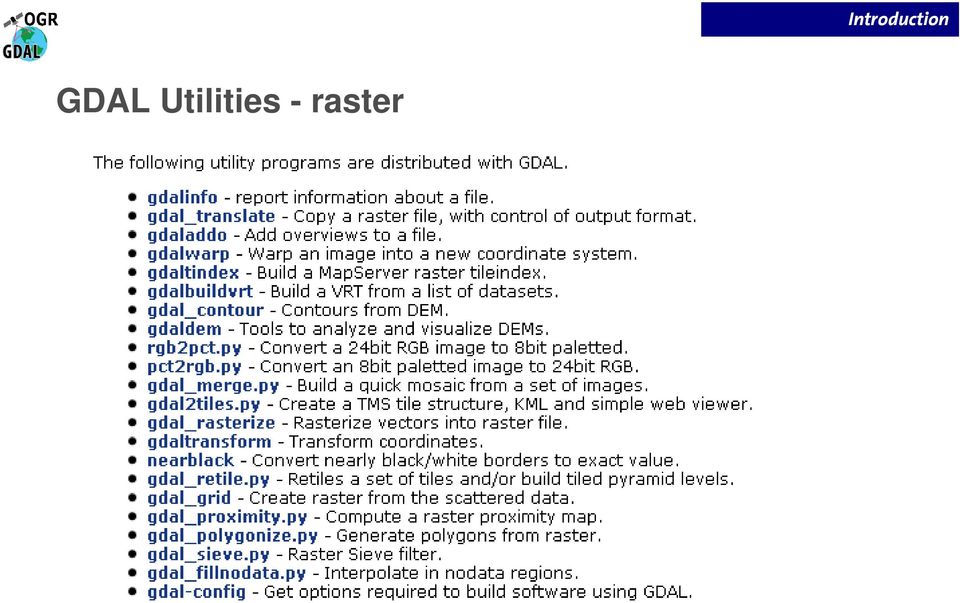
13 GDAL Utilities - raster Introduction
14 Introduction OGR Utilities vector ogrinfo list information about data source ogr2ogr convert data between file formats ogrtindex create tile index ( cut up shape files)

15 Introduction gvsig Generalidad Valenciana Conselleria d'infraestructures i Transport project - Spanish Community of Valencia mid range Desktop GIS based on open standards part of gvpontis project moria/gvpontis_ingles.pdf

16 Introduction project - Spanish province of Extremadura Sistema Extremeno de Analisis Territorial java based plug-in for gvsig offers more than 270 spatial functions raster and vector processing originally targeted at forestry usage initially based on SAGA GIS

17 Introduction gvsig is a project of the Spanish province of Valencia. The goals of the project are to provide an open source GIS that is platform independent and based on open source standards. Basically the capabilities should be comprehensive enough to replace ESRI s ArcView 3 desktop GIS. The user interface and functionalities of gvsig are similar to ArcView 3, but in addition has capabilities to connect to Internet mapping services. Another Java based project of the autonomous region of Extremadura called Sextante can be installed as a plug-in and offers more than 270 spatial functions.

18 gvsig and Sextante facts Introduction

19 gvsig Oxford Archeology BETA 2010 version based on gvsig 1.9 Introduction

20 Map View Cartography transparent hillshade Introduction

21 Table tools - add, rename, delete Introduction
22 gvsig Geoprocessing Tools Introduction
23 Sextante Toolbox (in gvsig) Introduction
24 Layout Introduction
25 Introduction PostGIS Spatial Database PostGIS is an extension for PostgreSQL adds support for geographic objects to PostgreSQL enables PostgreSQL server to be used as a backend spatial database for GIS Spatial operations and analysis simply mean running a (spatial) SQL query in the database Similar functions as SDE and much more.
26 PostGIS facts Introduction

27 pgadmin GUI base Database administration tool Introduction

28 Introduction PostGIS tables geometry columns spatial reference table
29 Introduction Articles The State of Open Source GIS, Version September By Paul Ramsey, formerly Refractions Research, Victoria. 49pages. Comparison Of Geographic Information System Software (Arcgis 9.0 And Grass 6.0): Implementation And Case Study MS Thesis by Todd R. Buchanan, Fort Hays State University. 89pages Geospatial Interoperability Return on Investment Study, National Aeronautics and Space Administration, Geospatial Interoperability Office, April pages Web Sites Free GIS Project Open source GIS list Map Tools OSGeo
30 Live DVD background
31 Part II Examples
32 Examples for Spatial Analysis and Geoprocessing using OGR/GDAL, gvsig and PostGIS Examples 1 desktop utilities to manipulate vector and raster data sources 2 3 desktop utilities to manipulate vector and raster data sources desktop utilities to manipulate vector and raster data sources
33 Examples ogrinfo (vector data) list shape file attributes ogrinfo so counties2008.shp counties2008 list PostGIS table attributes ogrinfo so PG:"host= user=postgres password=postgres dbname=workshop port=5432" counties summary list personal geodatabase table attributes ogrinfo -so streamnet_fishdist.mdb Fish_AllSpeciesCombined
34 Examples ogr2ogr (vector data) convert shape file to KML ogr2ogr -f "KML" newcounties.kml counties.shp select from shape file and write to new shape file ogr2ogr -sql "SELECT * FROM uninhabited WHERE AREA > " biguninhabited.shp uninhabited.shp
35 Examples gdalinfo, gdal_translate (raster data) list raster file attributes gdalinfo wa_shade_1km.tif convert format gdal_translate -of png" wa_shade_1km.tif wa_shade_1km.png
36 Examples gdalwarp (raster data) reproject to geographic 4326 gdalwarp -t_srs "epsg:4326" wa_shade_1km.tif wa_shade_1km_4326.tiff
37 Examples gdaldem Tools to analyze and visualize DEMs. (GDAL 1.7.0) shaded relief map gdaldem hillshade input_dem output_hillshade slope map gdaldem slope input_dem output_slope_map aspect map gdaldem aspect input_dem output_aspect_map

38 Overlay - Difference Examples
39 Examples functionality examples reprojection batch processing dissolve format conversion editing

40 Examples Importing data into PostGIS shp2pgsql + pgsql2shp shp2pgsql -I -s 2285 counties2008.shp counties_pg > counties.sql psql -U postgres -d weave f counties.sql Can combine both with ogr2ogr ogr2ogr -f "PostgreSQL" PG:"host=localhost user=postgres port=5432 dbname=workshop password=postgres" streamnet_fishdist.mdb -lco GEOMETRY_NAME=the_geom -t_srs "EPSG:2285" -nln "Fish_AllSpeciesCombined fishspecies user interfaces gvsig etc.
41 Examples Interacting with PostGIS Command line pgsql psql -U postgres -d workshop Graphical user interfaces (gui) pgadmin Squirrel SQL Client
42 Examples PostGIS Functions Spatial SQL
43 Examples Simple spatial operations Output format select askml(the_geom) from counties2008 where name ilike king ; Human readable geometry select astext(the_geom) from counties where name ilike 'King'; Distance select distance(setsrid((makepoint( , )),2285), setsrid((makepoint( , )),2285)); Transform Select transform((setsrid(makepoint( , ),2285)),4326);
44 Examples More spatial operations Buffer Select st_buffer(st_simplify(the_geom, 700), 9000) from wa_counties where name ilike 'King'; Intersect select name from counties where counties.the_geom && (setsrid((makepoint( , )),2285)) and intersects (counties.the_geom,setsrid((makepoint( , )),2285));
45 Examples Aggregate functions - Union of polygons Union all counties of the county polygon data set "us_counties " to create one polygon encompassing the area of the entire US. select st_union(the_geom) into us_border from us_counties This operation unions all individual datasets and groups them by states. select st_union (the_geom), state_name into us_states from us_counties group by state_name;
46 Part III Real world tasks using OS tools
47 Real world tasks using OS tools Using OS tools for your everyday Spatial Analysis and Geoprocessing Tasks We are using a real project to illustrate usage of our OS GIS tools
48 Real world tasks using OS tools Our task: determine land cover classes coverage for each State and break down by County. For each of the 962 Counties in the 12 State region report area in m 2
49 Using NASA MODIS 500m Imagery Land Cover Type Yearly L3 Global 500m MCD12Q1 ftp://e4ftl01u.ecs.nasa.gov/mota/mc D12Q1.005/ + Counties Layer Real world tasks using OS tools class value water 0 evergreen needleleaf forest 1 evergreen broadleaf forest 2 deciduous needleleaf forest 3 deciduous broadleaf forest 4 mixed forests 5 closed shrubland 6 open shrublands 7 woody savannas 8 savannas 9 grasslands 10 permanent wetlands 11 croplands 12 urban and built-up 13 cropland/natural vegetation mosaic 14 snow and ice 15 barren or sparsely vegetated 16 unclassified 254
 Real world tasks using OS")
50 Result would be a table like this (Counties shown with FIPS code ids) Real world tasks using OS tools
51 Real world tasks using OS tools Workflow project raster and vector data into Albers equal area projection translate MODIS Raster data transform from.hdf (Hierarchical Data Format) to geotif mosaic tiles into one image
52 Real world tasks using OS tools More data preparation Create Project Area County layer add County layer to gvsig select Counties in the 12 States and export as shape Create detailed State Boundaries from Counties layer (to be able to easily calculate area by State) select Counties in 11 States region and export as shape file Import into PostGIS union (dissolve) County geometries by State

53 Sextante Modeler Real world tasks using OS tools
54 Sextante Modeler Create Model Real world tasks using OS tools Input layer 1: counties in project area Input layer 2: land cover raster image (layer 3) Process step 1: rasterize County layer Process step 2: tabulate area operation: input rasterized County layer (3) -> regions land cover raster -> values limit to view extent (not to start a lengthy analysis) check tabulated result table export to MS Excel (or open office) process in MS Excel (transpose) join to Counties layer
55 Resources September 6-9,2010
56 Resources Conferences Year Location Dates URL 2010 Barcelona, Spain September 6-9, Sydney, Australia October 20-23, Cape Town, South Africa Sep/Oct Victoria, Canada September Lausanne, Switzerland September User Groups CUGOS Cascadia Users of Geospatial Open Source Seattle PDX OSGIS Portland Area Portland BAUGOS Bay Area Users of Geospatial Open Source San Francisco FRUGOS Front Range Users of Geospatial Open Source Colorado
57 THE END Contact Me with Questions Karsten Vennemann Seattle, WA, USA Terra gis Ltd Offers GIS consulting and training
An Introduction to Open Source Geospatial Tools
 An Introduction to Open Source Geospatial Tools by Tyler Mitchell, author of Web Mapping Illustrated GRSS would like to thank Mr. Mitchell for this tutorial. Geospatial technologies come in many forms,
Open Source Geospatial Software. Bob Bruce, P.Eng Mapping and Lands Branch, Manitoba Conservation WWW.HWPS.CA Bob.Bruce@gov.mb.ca
 A Survey of Open Source Geospatial Software Bob Bruce, P.Eng Mapping and Lands Branch, Manitoba Conservation WWW.HWPS.CA Bob.Bruce@gov.mb.ca APEGM PD Breakfast Tuesday, 12 June 2007 access this presentation
gvsig: A GIS desktop solution for an open SDI.
 gvsig: A GIS desktop solution for an open SDI. ALVARO ANGUIX1, LAURA DÍAZ1, MARIO CARRERA2 1 IVER Tecnologías de la Información. Valencia, Spain. Tel. +34 96 316 34 00; Fax. +34 96 316 34 00 Email: alvaro.anguix@iver.es
Standards based spatial data management, GIS and web mapping. Spatial data management, analysis & sharing the free & easy way!
 or Spatial data management, analysis & sharing the free & easy way! Premise: Traditional GIS is inherently flawed, especially when it comes to many fisheries/maritime datasets Premise: Traditional GIS
Design/build and visualization of political and social-statistics. statistics geodatabase by open source tools
 Design/build and visualization of political and social-statistics statistics geodatabase by open source tools Ferenc Speiser Post-graduate distance learning course in Geoinformatics Contents The goals
Documentation of open source GIS/RS software projects
 Contract no. Workpackage Delivery Delivery Date 030776 WP1 D1.6 2007-07-02 CASCADOSS Development of a trans-national cascade training programme on Open Source GIS&RS Software for environmental applications
Oklahoma s Open Source Spatial Data Clearinghouse: OKMaps
 Oklahoma s Open Source Spatial Data Clearinghouse: OKMaps Presented by: Mike Sharp State Geographic Information Coordinator Oklahoma Office of Geographic Information MAGIC 2014 Symposium April 28-May1,
Institute of Natural Resources Departament of General Geology and Land use planning Work with a MAPS
 Institute of Natural Resources Departament of General Geology and Land use planning Work with a MAPS Lecturers: Berchuk V.Y. Gutareva N.Y. Contents: 1. Qgis; 2. General information; 3. Qgis desktop; 4.
Introduction to OSGeo and QGIS
 Introduction to OSGeo and QGIS Arnulf Christl OSGeo President Emeritus ESTGIS Pühajärve, Estonia Arnulf Christl Geospatial Systems Architect OSGeo President Emeritus Director of the metaspatial Institute
The OSGeo Foundation. FOSS4G Korea 2011 Seoul. Professionally leveraging Open Source Geospatial. Arnulf Christl President
 The OSGeo Foundation Professionally leveraging Open Source Geospatial Arnulf Christl President FOSS4G Korea 2011 Seoul Arnulf Christl Works as Geospatial Systems Architect in his company metaspatial. President
Introduction to Web-based GIS
 1. Overview Introduction to Web-based GIS by Tara Athan tara_athan@alt2is.com 1-707-485-1198 Web-based GIS differs from traditional GIS or paper maps in several important ways that may at times be advantageous
Open Source GIS. Open Source GIS. Agenda. Open Source. Typische GIS Funktionen. LOTS Bern 18.2.05
 Agenda LOTS Bern 18.2.05 Pirmin Kalberer Sourcepole AG, Bad Ragaz www.sourcepole.ch Typische GIS Anwendungen Datenformate und GIS-Datenbanken Standards & Protokolle Bibliotheken & Applikationen Fragen
Open Source GIS The Future?
 Open Source GIS The Future? Daniel Morissette DM Solutions Group Inc. Open Source Licensing No licensing costs Unlimited rights to: Use the software View and analyse the source Copy, reuse in other systems
Open Source GIS Blitz!
 Open Source GIS Blitz! Startwiththisvideo http://vimeo.com/2598878 Openstreetmap.org Crown copyright no expiration all government map data in England. Rest of Europe not much better Volunteer mapping effort.
Mapping Mashup/Data Integration Development Resources Teaching with Google Earth and Google Ocean Stone Lab August 13, 2010
 Mapping Mashup/Data Integration Development Resources Teaching with Google Earth and Google Ocean Stone Lab August 13, 2010 David Hart GIS Specialist University of Wisconsin Sea Grant Institute Virtual
Institute of Computational Modeling SB RAS
 Institute of Computational Modeling SB RAS ORGANIZATION OF ACCESS TO OBSERVATIONAL DATA USING WEB SERVICES FOR MONITORING SYSTEMS THE STATE OF THE ENVIRONMENT Kadochnikov Aleksey A. Russia, Krasnoyarsk
Choosing the right GIS framework for an informed Enterprise Web GIS Solution
 13 ANNUAL INTERNATIONAL CONFERENCE AND EXHIBITION ON GEOSPATIAL INFORMATION TECHNOLOGY AND APPLICATIONS Epicentre; Gurgaon, India; 19-21 January, 2010 Choosing the right GIS framework for an informed Enterprise
Analysis of the Free GIS Software Applications in respect to INSPIRE services and OGC standards
 Analysis of the Free GIS Software Applications in respect to INSPIRE services and OGC standards Authors: Francesco D'Alesio Peter Hopfgartner Paolo Viskanic June 2011 Executive Summary This document analyses
County of Los Angeles. Chief Information Office Preferred Technologies for Geographic Information Systems (GIS) September 2014
 September 2014") County of Los Angeles Chief Information Office Preferred Technologies for Geographic Information Systems (GIS) September 2014 CIO Preferred Technologies for GIS This document lists the preferred Geographic
County of Los Angeles Chief Information Office Preferred Technologies for Geographic Information Systems (GIS) September 2014 CIO Preferred Technologies for GIS This document lists the preferred Geographic
The Use of Geographic Information Systems in Risk Assessment
 The Use of Geographic Information Systems in Risk Assessment With Specific Focus on the RiVAMP Methodology Presented by Nadine Brown August 27, 2012 Climate Studies Group Mona Climate Change Workshop Presentation
From a niche to a global user community: Open Source GIS and OSGeo
 From a niche to a global user community: Open Source GIS and OSGeo Opensource Geospatial Research Symposium Nantes, 8-10 July 2009 http://www.ogrs2009.org Markus Neteler Fondazione E Mach - CRI Italy,
Building a Spatial Database in PostgreSQL
 Building a Spatial Database in PostgreSQL David Blasby Refractions Research dblasby@refractions.net http://postgis.refractions.net Introduction PostGIS is a spatial extension for PostgreSQL PostGIS aims
Future Trends in Geospatial Data Management Process Squadron Leader Mudit Mathur
 VOL 2 ISSUE 5 24 TOWARDS A NATIONAL SPATIAL DATA INFRASTRUC- TURE (NSDI) Dr. Talal Al-Awadhi 28 GEODATABASE FOR URBAN DESIGN AND PLANNING Simon Yanuar PUTRA 34 FREE, CHEAP, AND POW- ERFUL POSTGIS, THE
Data Integration for ArcGIS Users Data Interoperability. Charmel Menzel, ESRI Don Murray, Safe Software
 Data Integration for ArcGIS Users Data Interoperability Charmel Menzel, ESRI Don Murray, Safe Software Product overview Extension to ArcGIS (optional) Jointly developed with Safe Software Based on Feature
OSGeo Web Mapping Typification: GeoMajas, Mapbender, MapFish and OpenLayers. Christoph Baudson Arnulf Christl FOSS4G 2010 Barcelona
 OSGeo Web Mapping Typification: GeoMajas, Mapbender, MapFish and OpenLayers Christoph Baudson Arnulf Christl FOSS4G 2010 Barcelona Disclaimer All information contained in this presentation has been compiled
Open Source tools for geospatial tasks
 Open Source tools for geospatial tasks Some alternatives to commercial software packages (ricardd@mathstat.dal.ca) Graduate Student Department of Biology Dalhousie University Workshop on Inshore Ecosystems
SUMMER SCHOOL ON ADVANCES IN GIS
 SUMMER SCHOOL ON ADVANCES IN GIS Six Workshops Overview The workshop sequence at the UMD Center for Geospatial Information Science is designed to provide a comprehensive overview of current state-of-the-art
Web Mapping in Archaeology
 Non-invasive methods in the contemporary archaeological practice 25th February 2014 http://www.pborycki.pl/pdf/webmapping.pdf Plan of the presentation 1 Web Mapping General Idea History of Web Mapping
Open Source Alternatives to Commercial GIS Tools
 UW-Milwaukee GIS Day November 17 th Open Source Alternatives to Commercial GIS Tools James Beaudoin Applied Population Laboratory, University of Wisconsin-Madison Applied Population Laboratory Department
UK Location Programme
 Location Information Interoperability Board Data Publisher How To Guide Understand the background to establishing an INSPIRE View Service using GeoServer DOCUMENT CONTROL Change Summary Version Date Author/Editor
The Courses. Covering complete breadth of GIS technology from ESRI including ArcGIS, ArcGIS Server and ArcGIS Engine.
 ESRI India: Corporate profile ESRI India A profile India s Premier GIS Company Strategic alliance between ESRI Inc. and NIIT Technologies Adjudged as India s Best GIS Solutions Company - Map India 2001
Treading Into Open Source GIS
 Treading Into Open Source GIS 49th Annual Alaska Surveying & Mapping Conference February 18 th, 2015 David Howes, Ph.D. - David Howes, LLC dhowes.com Jason Pardy - NewfoundGEO Consulting newfoundgeo.com
Chapter 6: Data Acquisition Methods, Procedures, and Issues
 Chapter 6: Data Acquisition Methods, Procedures, and Issues In this Exercise: Data Acquisition Downloading Geographic Data Accessing Data Via Web Map Service Using Data from a Text File or Spreadsheet
Pennsylvania Geospatial Data Sharing Standards (PGDSS) V 2.5
 V 2.5") Submitted to: Pennsylvania Geospatial Data Sharing Standards (PGDSS) V 2.5 Spatial Data Migration Tools Report May 2, 2007 Table of Contents 1.0 Document Purpose...B-1 2.0 Overview of Spatial Data Migration
Submitted to: Pennsylvania Geospatial Data Sharing Standards (PGDSS) V 2.5 Spatial Data Migration Tools Report May 2, 2007 Table of Contents 1.0 Document Purpose...B-1 2.0 Overview of Spatial Data Migration
A Web services solution for Work Management Operations. Venu Kanaparthy Dr. Charles O Hara, Ph. D. Abstract
 A Web services solution for Work Management Operations Venu Kanaparthy Dr. Charles O Hara, Ph. D Abstract The GeoResources Institute at Mississippi State University is leveraging Spatial Technologies and
GeoKettle: A powerful open source spatial ETL tool
 GeoKettle: A powerful open source spatial ETL tool FOSS4G 2010 Dr. Thierry Badard, CTO Spatialytics inc. Quebec, Canada tbadard@spatialytics.com Barcelona, Spain Sept 9th, 2010 What is GeoKettle? It is
Web and Mobile GIS Applications Development
 Web and Mobile GIS Applications Development Presented by : Aamir Ali Manager Section Head (GIS Software Customization) Pakistan Space and Upper Atmosphere Research Commission (SUPARCO) Geographical Information
GIS Databases With focused on ArcSDE
 Linköpings universitet / IDA / Div. for human-centered systems GIS Databases With focused on ArcSDE Imad Abugessaisa g-imaab@ida.liu.se 20071004 1 GIS and SDBMS Geographical data is spatial data whose
Introduction to GIS. http://libguides.mit.edu/gis
 Introduction to GIS http://libguides.mit.edu/gis 1 Overview What is GIS? Types of Data and Projections What can I do with GIS? Data Sources and Formats Software Data Management Tips 2 What is GIS? 3 Characteristics
A GIS helps you answer questions and solve problems by looking at your data in a way that is quickly understood and easily shared.
 A Geographic Information System (GIS) integrates hardware, software, and data for capturing, managing, analyzing, and displaying all forms of geographically referenced information. GIS allows us to view,
Open Source Desktop GIS Solutions for the Not-So Casual User
 Open Source Desktop GIS Solutions for the Not-So Casual User Roger C. Lowe III Warnell School of Forestry and Natural Resources The University of Georgia Athens, GA 30605 rlo@warnell.uga.edu Abstract Ask
Iraklis Karampourniotis, Zoi Arvanitidou, Ioannis Paraschakis. Using open source software in gis training and education
 Iraklis Karampourniotis, Zoi Arvanitidou, Ioannis Paraschakis Using open source software in gis training and education Can open source be used? The question troubling us was Can Open Source Software be
Introduction to Using PostGIS Training Workbook Last Updated 18 June 2014
 Introduction to Using PostGIS Training Workbook Last Updated 18 June 2014 Prepared by: Simon Nitz, Senior Technical Consultant Digital Mapping Solutions NZ Limited 2nd Floor, 20 Bridge Street, Ahuriri,
Archival Challenges Associated with the Esri Personal Geodatabase and File Geodatabase Formats
 Geospatial Multistate Archive and Preservation Partnership (GeoMAPP) Archival Challenges Associated with the Esri Personal Geodatabase and File Geodatabase Formats December 6, 2011 Introduction Spatial
Reading & Writing Spatial Data in R John Lewis. Some material used in these slides are taken from presentations by Roger Bivand and David Rossiter
 Reading & Writing Spatial Data in R John Lewis Some material used in these slides are taken from presentations by Roger Bivand and David Rossiter Introduction Having described how spatial data may be represented
DEVELOPMENT OF REAL-TIME TRACKING & LOG MANAGEMENT SYSTEM USING FREE AND OPEN SOURCE SOFTWARE
 DEVELOPMENT OF REAL-TIME TRACKING & LOG MANAGEMENT SYSTEM USING FREE AND OPEN SOURCE SOFTWARE Daisuke Yoshida and Venkatesh Raghavan Graduate School for Creative Cities, Osaka City University 3-3-138 Sugimoto,
INTRODUCTION TO ARCGIS SOFTWARE
 INTRODUCTION TO ARCGIS SOFTWARE I. History of Software Development a. Developer ESRI - Environmental Systems Research Institute, Inc., in 1969 as a privately held consulting firm that specialized in landuse
ARCHITECTURE OF INTEGRATED GIS AND GPS FOR VEHICLE MONITORING
 1 st Logistics International Conference Belgrade, Serbia 28-30 November 2013 ARCHITECTURE OF INTEGRATED GIS AND GPS FOR VEHICLE MONITORING Adela B. Crnišanin * State University of Novi Pazar, Department
GIS Architecture and Data Management Practices Boone County GIS Created and Maintained by the Boone County Planning Commission GIS Services Division
 GIS Architecture and Data Management Practices Boone County GIS Created and Maintained by the Boone County Planning Commission June 2008 Background Boone County s GIS program has been in existence for
Mapping Mashup/Data Integration Development Resources
 Mapping Mashup/Data Integration Development Resources David Hart GIS Specialist University of Wisconsin Sea Grant Institute October 6, 2008 Virtual Globes A virtual globe is a 3D software model or representation
Chapter 5 Spatial is not Special: Managing Tracking Data in a Spatial Database
 Chapter 5 Spatial is not Special: Managing Tracking Data in a Spatial Database Ferdinando Urbano and Mathieu Basille Abstract A wildlife tracking data management system must include the capability to explicitly
NetCDF and HDF Data in ArcGIS
 2013 Esri International User Conference July 8 12, 2013 San Diego, California Technical Workshop NetCDF and HDF Data in ArcGIS Nawajish Noman Kevin Butler Esri UC2013. Technical Workshop. Outline NetCDF
OPEN STANDARD WEB SERVICES FOR VISUALISATION OF TIME SERIES DATA OF FLOOD MODELS
 OPEN STANDARD WEB SERVICES FOR VISUALISATION OF TIME SERIES DATA OF FLOOD MODELS Barend Köbben FRMRC RPA 7 Workshop visualisations and flow simulations as flood risk communication tools
MrSID Plug-in for 3D Analyst
 LizardTech MrSID Plug-in for 3D Analyst User Manual Copyrights Copyright 2009 2010 LizardTech. All rights reserved. Information in this document is subject to change without notice. The software described
Standardized data sharing through an open-source Spatial Data Infrastructure: the Afromaison project
 Standardized data sharing through an open-source Spatial Data Infrastructure: the Afromaison project Yaniss Guigoz - University of Geneva/GRID-Geneva 1 EcoARM2ERA and AFROMAISON Why Afromaison in this
Vector analysis - introduction Spatial data management operations - Assembling datasets for analysis. Data management operations
 Vector analysis - introduction Spatial data management operations - Assembling datasets for analysis Transform (reproject) Merge Append Clip Dissolve The role of topology in GIS analysis Data management
Using CAD Data in ArcGIS
 Esri International User Conference San Diego, California Technical Workshops July 27, 2012 Using CAD Data in ArcGIS Jeff Reinhart & Phil Sanchez Agenda Overview of ArcGIS CAD Support Using CAD Datasets
Spatial Database Support
 Page 1 of 11 Spatial Database Support Global Mapper can import vector data from and export vector data to the following spatial databases: Esri ArcSDE Geodatabase Esri File Geodatabase Esri Personal Geodatabases
An overview on current free and open source desktop GIS developments
 International Journal of Geographical Information Science Vol. 23, No. 10, October 2009, 1345 1370 Review Article An overview on current free and open source desktop GIS developments STEFAN STEINIGER*{
Frank Warmerdam President, OSGeo
 PostGIS: A Standards Based Geographic Extension for PostgreSQL Frank Warmerdam President, OSGeo 1 Overview Brief background PostGIS Details PostGIS Ex am ples Survey of Sim ple Features 1.1 Geom etries
gvsig: Open Source GIS client. Spatial Data Infrastructure Client.
 Séminaire gvsig Rennes, 31 Mars 2006 gvsig: Open Source GIS client. Spatial Data Infrastructure Client. Luis W. Sevilla Gabriel Carrión Rico Martín García Hernández Francisco J. Peñarrubia Alvaro A. Anguix
JNCC Report No: 542. QGIS Suitability Assessment. Claire E. Lush & Mike J. Lush. November 2014. JNCC, Peterborough 2014 ISSN 0963 8901
 JNCC Report No: 542 QGIS Suitability Assessment Claire E. Lush & Mike J. Lush November 2014 JNCC, Peterborough 2014 ISSN 0963 8901 For further information please contact: Joint Nature Conservation Committee
Free and Open Source Geospatial Tools for Environmental Modeling and Management
 Free and Open Source Geospatial Tools for Environmental Modeling and Management A. Jolma a, D.P. Ames b, N. Horning c, M. Neteler d, A. Racicot e and T. Sutton f a Helsinki University of Technology, Espoo,
Free and Open Source GIS Software for Building a Spatial Data Infrastructure
 Free and Open Source GIS Software for Building a Spatial Data Infrastructure Stefan Steiniger, Andrew J. S. Hunter Department of Geomatics Engineering, University of Calgary, 2500 University Drive NW,
Introduction to GIS (Basics, Data, Analysis) & Case Studies. 13 th May 2004. Content. What is GIS?
 & Case Studies. 13 th May 2004. Content. What is GIS?") Introduction to GIS (Basics, Data, Analysis) & Case Studies 13 th May 2004 Content Introduction to GIS Data concepts Data input Analysis Applications selected examples What is GIS? Geographic Information
Introduction to GIS (Basics, Data, Analysis) & Case Studies 13 th May 2004 Content Introduction to GIS Data concepts Data input Analysis Applications selected examples What is GIS? Geographic Information
TRD 05: Data Presentation techniques (Mapping) Quantum GIS User Guide
 Quantum GIS User Guide") THE REGIONAL TRAINING WORKSHOP ON LARVAL FISH IDENTIFICATION AND FISH EARLY LIFE HISTORY SCIENCE SEAFDEC/TD, SAMUT PRAKAN, THAILAND 16 31 MAY 2007 TRD 05: Data Presentation techniques (Mapping) Quantum
THE REGIONAL TRAINING WORKSHOP ON LARVAL FISH IDENTIFICATION AND FISH EARLY LIFE HISTORY SCIENCE SEAFDEC/TD, SAMUT PRAKAN, THAILAND 16 31 MAY 2007 TRD 05: Data Presentation techniques (Mapping) Quantum
Open Source Software Communities - Lessons Learnt
 1 Open Source Software Communities - Lessons Learnt Imed Hammouda, adjunct professor Alexander Lokhman, researcher Tampere University of Technology 25.2.2011 Open Source vs. Free Software 2 Free software
OSM GB. Introduction. Users Requirements. Abstract OSM GB
 OSM GB Using Open Source Geospatial Tools to Create OSM Web Services for Great Britain by Amir Pourabdollah University of Nottingham, United Kingdom. amir.pourabdollah@nottingham.ac.uk Abstract A use case
GEOENGINE MSc in Geomatics Engineering, Master Thesis Gina Campuzano
 Master Thesis Gina CAMPUZANO Gina Campuzano Development of a GIS web application as a tool for learning of environmental protection -Comparison between MapServer and GeoServer constructing a tool for not
Cloud-based Geospatial Data services and analysis
 Cloud-based Geospatial Data services and analysis Xuezhi Wang Scientific Data Center Computer Network Information Center Chinese Academy of Sciences 2014-08-25 Outlines 1 Introduction of Geospatial Data
J9.6 GIS TOOLS FOR VISUALIZATION AND ANALYSIS OF NEXRAD RADAR (WSR-88D) ARCHIVED DATA AT THE NATIONAL CLIMATIC DATA CENTER
 ARCHIVED DATA AT THE NATIONAL CLIMATIC DATA CENTER") J9.6 GIS TOOLS FOR VISUALIZATION AND ANALYSIS OF RADAR (WSR-88D) ARCHIVED DATA AT THE NATIONAL CLIMATIC DATA CENTER Steve Ansari * STG Incorporated, Asheville, North Carolina Stephen Del Greco NOAA National
J9.6 GIS TOOLS FOR VISUALIZATION AND ANALYSIS OF RADAR (WSR-88D) ARCHIVED DATA AT THE NATIONAL CLIMATIC DATA CENTER Steve Ansari * STG Incorporated, Asheville, North Carolina Stephen Del Greco NOAA National
Comparison of Open Source Virtual Globes
 FOSS4G 2010 Comparison of Open Source Virtual Globes Mathias Walker Pirmin Kalberer Sourcepole AG, Bad Ragaz www.sourcepole.ch About Sourcepole GIS-Knoppix: first GIS live-cd QGIS Core developer QGIS Mapserver
Evaluating open source GIS for libraries Francis P. Donnelly Newman Library, Baruch College, City University of New York, New York, USA
 The current issue and full text archive of this journal is available at www.emeraldinsight.com/0737-8831.htm Evaluating open Francis P. Donnelly Newman Library, Baruch College, City University of New York,
SQL SUPPORTED SPATIAL ANALYSIS FOR WEB-GIS INTRODUCTION
 SQL SUPPORTED SPATIAL ANALYSIS FOR WEB-GIS Jun Wang Jie Shan Geomatics Engineering School of Civil Engineering Purdue University 550 Stadium Mall Drive, West Lafayette, IN 47907 ABSTRACT Spatial analysis
National critical geo infrastructure runs on open source database PostGIS
 National critical geo infrastructure runs on open source database PostGIS TU Delft Geomatics Open Guest Lecture March 21st 2011 Thijs Brentjens Who am I? TU Delft MSc Geodetic Engineering (2004) Thesis:
A WEB GIS FOR WETLANDS OF KERALA USING OPEN SOURCE GEOSPATIAL SOFTWARE. Santosh Gaikwad* and S Narendra Prasad**
 A WEB GIS FOR WETLANDS OF KERALA USING OPEN SOURCE GEOSPATIAL SOFTWARE Santosh Gaikwad* and S Narendra Prasad** Salim Ali Centre for Ornithology and Natural History Deccan Regional Station, Hyderabad *gaikwadss@rediffmail.com
Data Interoperability Extension Tutorial
 Data Interoperability Extension Tutorial Copyright 1995-2010 Esri All rights reserved. Table of Contents About the Data Interoperability extension tutorial...................... 3 Exercise 1: Using direct-read
gvsig: Open Source for handling Geospatial Information
 gvsig: Open Source for handling Geospatial Information Mario Carrera Rodríguez carrera_marrod@gva.es Generalitat Valenciana (GV) is the government of the Valencian Community (Castellón, Valencia, Alicante)
GeoPackage, The Shapefile Of The Future
 FOSS4G 2013 GeoPackage, The Shapefile Of The Future @PirminKalberer Sourcepole AG, Switzerland www.sourcepole.com About Sourcepole > QGIS > Core dev. & Project Steering Commitee > QGIS Server, Printing,
GIS Training Express
 King County GIS Center s It s Not the GIS Tools & Data It s What You Do With Them! King County GIS Center Cheryl Wilder, GISP, CTT+, GIS Training Coordinator Dennis Higgins, GISP, Client Services Manager
PostGIS Data Integration
 PostGIS Data Integration & Display on SIS Alex Hill GIS Manager Contents Plus Dane Group who we are PostGIS Data Integration and Display on SIS What is a Spatial Database? What is PostgreSQL/PostGIS? Why
ArcGIS. Server. A Complete and Integrated Server GIS
 ArcGIS Server A Complete and Integrated Server GIS ArcGIS Server A Complete and Integrated Server GIS ArcGIS Server enables you to distribute maps, models, and tools to others within your organization
WP 3. Elaboration database Architecture Features (Software Architecture Document)
") Architecture Features (Software Architecture Document) o Best in class solution, using EC recommendations for IT in this field o Implementation based on free open source o Based on OGC standards, high
Architecture Features (Software Architecture Document) o Best in class solution, using EC recommendations for IT in this field o Implementation based on free open source o Based on OGC standards, high
Interoperable Solutions in Web-based Mapping
 ISPRS SIPT IGU UCI CIG ACSG Table of contents Table des matières Authors index Index des auteurs Search Recherches Exit Sortir Interoperable Solutions in Web-based Mapping Marta Wojnarowska and Bridget
 Development tools to create Web-GIS applications DbMAP ASJ the best solution to easily publish GIS data from existing spatial databases and distributed GIS data sources Easily designs, produces, and publishes
Developing of A GIS Based Enviromental Monitoring System with Open Source Softwares
 L. Kottyán, G. Nagy, A. Szepes Developing of A GIS Based Enviromental Monitoring System with Open Source Softwares Developing of A GIS Based Enviromental Monitoring System with Open Source Softwares László
GIS Data in ArcGIS. Pay Attention to Data!!!
 GIS Data in ArcGIS Pay Attention to Data!!! 1 GIS Data Models Vector Points, lines, polygons, multi-part, multi-patch Composite & secondary features Regions, dynamic segmentation (routes) Raster Grids,
Data Validation Online References
 Data Validation Online References Submitted To: Program Manager GeoConnections Victoria, BC, Canada Submitted By: Jody Garnett Brent Owens Refractions Research Inc. Suite 400, 1207 Douglas Street Victoria,
Geodatabase Programming with SQL
 DevSummit DC February 11, 2015 Washington, DC Geodatabase Programming with SQL Craig Gillgrass Assumptions Basic knowledge of SQL and relational databases Basic knowledge of the Geodatabase We ll hold
ArcGIS Framework Plug-In: Extending the ArcGIS Desktop for ANSI Standard Framework Data to Support Government Decision Making
 ArcGIS Framework Plug-In: Extending the ArcGIS Desktop for ANSI Standard Framework Data to Support Government Decision Making Final Project Report October 28, 2008 Agreement Number Organization Project
WCS as Candidate INSPIRE Download Service for Coverage Data
 WCS as Candidate INSPIRE Download Service for Coverage Data Alexander Kotsev www.jrc.ec.europa.eu Serving society Stimulating innovation Supporting legislation Context NS Regulation defines two types of
GEOGRAPHIC INFORMATION SYSTEMS Lecture 20: Adding and Creating Data
 Adding Existing Data Into ArcGIS - there are many different ways to get data into ArcGIS GEOGRAPHIC INFORMATION SYSTEMS Lecture 20: Adding and Creating Data Add Data - normally we use the Add Data button
What's new in gvsig Desktop 2.0
 What's new in gvsig Desktop 2.0 What are the novelties? 2.0 1.12 Migrating and building... Some examples... Please pardon our appearance during construction Pie and bar chart legends Table in layout 1.12
Editing Strategies for Enterprise Geodatabase
 Federal GIS Conference February 9 10, 2015 Washington, DC Editing Strategies for Enterprise Geodatabase Ty Fabling Esri Solution Engineer A Complete Platform Enabling GIS Everywhere Desktop Web Device
Creating a File Geodatabase
 Creating a File Geodatabase Updated by Thomas Stieve January 06, 2012 This exercise demonstrates how to create a file geodatabase in ArcGIS 10; how to import existing data into the geodatabase, and how
An Android based Quantum GIS prototype. Ramon Carrillo, Daniel Ochoa dochoa@espol.edu.ec
 An Android based Quantum GIS prototype Ramon Carrillo, Daniel Ochoa dochoa@espol.edu.ec Summary Background Past works Quantum GIS Mobile Quantum GIS Results Future works Background Robotic and computer
Implementation of information system to respond to a nuclear emergency affecting agriculture and food products - Case of Morocco
 Centre National de l énergie des sciences et techniques nucléaires (CNESTEN-Morocco) Implementation of information system to respond to a nuclear emergency affecting agriculture and food products - Case
ArcGIS 10.1 Geodatabase Administration. Gordon Sumerling & Christopher Brown
 ArcGIS 10.1 Geodatabase Administration Gordon Sumerling & Christopher Brown Key Improvements at ArcGIS 10.1 1. Easier Administration through Graphic Interfaces 2. Greater Seamless integration with Open
The 2012 Free and Open Source GIS Software Map A Guide to facilitate Research, Development and Adoption
 Version 8. August 2012 (1 1/2 Revision) accepted for publication in Computers, Environment and Urban Systems as of Oct. 2012 Review Article The 2012 Free and Open Source GIS Software Map A Guide to facilitate
INTRODUCTION GAIA RESOURCES. Environmental Consultants Association (WA) DATA SOURCES INFORMATION MANAGEMENT DATA SOURCES DATA SOURCES
 DATA SOURCES INFORMATION MANAGEMENT DATA SOURCES DATA SOURCES") INTRODUCTION GAIA RESOURCES Environmental Consultants Association (WA) Practitioners Guide to Information Management Data Sources and Tools Information Management what is it? Data Sources available Tools
INTRODUCTION GAIA RESOURCES Environmental Consultants Association (WA) Practitioners Guide to Information Management Data Sources and Tools Information Management what is it? Data Sources available Tools