Red Water Pond Road Community History through Pictures Past and Present of the Red House People April 2012, revised September 2012
|
|
|
- Roderick Shields
- 8 years ago
- Views:
Transcription
1 Red Water Pond Road Community History through Pictures Past and Present of the Red House People April 2012, revised September 2012 Compiled by Red Water Pond Road Community Association And Southwest Research and Information Center 1

2 Location Map for Red Water Pond Community Area Coyote Canyon Chapter, Navajo Nation 2

3 Contemporary Photos of Traditional Cultural Properties and Cultural Resource Sites in Red Water Pond Community Cornfield southeast of Henio home with Red Point Mesa in background. 3

4 Jack and Elsie Hood home built by Billy Duncan in the 1930s and moved to its presentation location in 1960s 4

5 Location of the old Yazzie s Hogan by Pipeline Road, circa 19xx 5

6 Cornfield seen from east side of Henio s home. This cornfield has been cultivated since the 1940s. 6

7 Petroglyphs: Sheepherder Inscription of 7/3/68 7

8 Standing Black Tree Mesa ( ) traditional use area Current (2012) Red Water Pond Community area Pipeline Road Community area Communities neighboring Red Water Pond Road Community 8

9 Standing Black Tree Mesa ( ) traditional family land 2 miles north of Red Water Pond Community Existing building Existing hogan Common area with arbor; routinely used by family 9

10 Stone remnants of Annie s on Standing Black Tree Mesa 10

11 Annie s old stone house, Standing Black Tree Mesa 11

12 The old Duncan Family s and summer camp 12

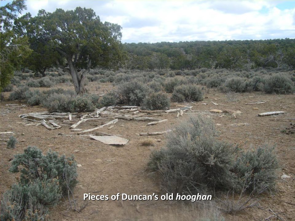
13 Pieces of Duncan s old 13
14 Sheep corral on Standing Black Tree Mesa 14

15 Old home site on Standing Black Tree Mesa; occupied circa early 1900s 15

16 Duncan s sweat lodge on Standing Black Tree Mesa summer camp 16

17 Third at Standing Black Tree Mesa summer camp 17

18 Willetto s on Standing Black Tree Mesa 18

19 Family picnic ground on Standing Black Tree Mesa This site has been used since the 1940s and continues to be used regularly for family gatherings. 19

20 Annual Picnic on 20

21 Sheepherders at Red Hill looking north toward Coyote Canyon Chapter 21
22 Grandparents Billy Duncan Bessie Duncan 22
23 Picture of Jackie/Jean before the mining began.. By the way Happy Birthday Jean! 23
24 1930s- 1940s Toddler Becky and Bennie Duncan with flock on Standing Black Tree Mesa 24
25 1936 Sheep Census 80- year History of Grazing 1942 Stock Reduction Notice from Interior Dept. Residents have livestock documentation dating back at least to Animal Counts 25
26 1950s View in background is future site of Kerr-McGee Mine 26
27 1950s- 1960s Edith: Only 4- year-old with a blanket and car Edith, Art, Berth 27
28 s Art Hood and nieces, late-80s; KM Mine waste in background Jack Hood, 1985; KM Mine waste in background Late 70s: Hood children play in shadow of Kerr-McGee/Quivira Church Rock I Mine 28
29 Uranium Mining Era, Top: United Nuclear Corp. Northeast Church Rock Mine (left, right); NECR Mine water ponds (middle), discharge to north. Bottom: Kerr-McGee Mine under development (left), construction crew (middle), Red Water Pond Road to KM Mine 29
30 Possible locations for permanent community center Kerr-McGee/Quivira Churchrock I and IE Mine United Nuclear Corp. (GE) Northeast Church Rock Mine United Nuclear Corp. (GE) Church Rock Uranium Mill United Nuclear Corp. (GE) Uranium Mill Tailings Disposal Area (NPL Site) 30
31 Church Rock Uranium Mill Tailings Spill July 16, 1979* (*remains the largest release of radioactive wastes, by volume, in US history) United Nuclear Corp. Uranium Mill Tailings Dam, July 16, 1979 Dam breach location, July 17, 1979 Puerco River warning sign NMEID Sampling in Puerco R. after spill Livestock tracks in Puerco River downstream of spill, July 17, 1979 Community leaders Larry J. King (L) and Robinson Kelly addressed longterm impacts of spill in Photos courtesy of Southwest Research and Information Center, New Mexico Environmental Improvement Division, Albuquerque Journal. 31
32 RWPR Area 32
33 year retrospective Northeast Church Rock Mine and Red Water Pond Road Community Radiation monitoring Mine water discharges from NECR Mine and Church Rock I mine released more radioactivity to Puerco River system over a 20- year period than in the 1979 tailings spill
34 34
35 Before and During Interim Removal Action 2003 North face of mine waste dump at NN boundary 2009 North face of mine waste dump after grading 2005 before removal 2009 during removal 35
36 : RWPRCA Sponsors Uranium Legacy Remembrance and Action Day 36
37 Eastern Drainage Area, 2012 Eastern Drainage Removal Area, looking east Quivira Mine Dump Eastern Drainage Removal Area Sept runoff from IRA heading east (toward camera) on South RWPR 37
38 Flash Flooding in August 2012 Pipeline Arroyo west of Quivira Mine Red Water Pond Road-South, looking east Pipeline Road crossing at Pipeline Arroyo Pipeline Road crossing at Pipeline Arroyo Photos by Teracita Keyanna 38
39 Panoramic View of Red Water Pond Community February 3, 2012 Eastern Drainage Removal Area, mid-2012 Soil removal area and revegetation area, 2007 and 2009 NECR Mine waste dump moved south and minewater arroyo, dredged and filled (16-25 ), Cornfield Quivira Mine dump (recontoured 2011) Hood brick house, circa 1940s Looking SE across Kerr- McGee/Quirivia Mine & Eastern Drainage Area Looking south across Step- Out Area #1, soil removal, revegetation, Looking south across Northeast Church Rock Mine Site with residences in middle ground. Looking southwest; RWPR in foreground, heading due west; western end of residential area in background. 39
The Navajo Nation Environmental Protection Agency (NNEPA) Superfund Program and Community Involvement
 Superfund Program and Community Involvement") The Navajo Nation Environmental Protection Agency (NNEPA) Superfund Program and Community Involvement Presented By: Freida S. White, Environmental Program Supervisor NNEPA Superfund Insert Slide Title
The Navajo Nation Environmental Protection Agency (NNEPA) Superfund Program and Community Involvement Presented By: Freida S. White, Environmental Program Supervisor NNEPA Superfund Insert Slide Title
Federal Actions to Address Impacts of Uranium Contamination in the Navajo Nation
 2014 Federal Actions to Address Impacts of Uranium Contamination in the Navajo Nation TABLE OF CONTENTS Executive Summary... 1 Introduction... 2 Summary of Work Completed 2008-2012... 2 Objectives... 4
Soil and Materials Engineers, Inc. Mark J. Quimby Project Consultant
 Soil and Materials Engineers, Inc. Mark J. Quimby Project Consultant Michigan Indiana Ohio www.sme-usa.com consultants in the environment, geosciences and materials OVERVIEW Site Description and History
Final Report. Dixie Creek Restoration Project. Funded by Plumas Watershed Forum
 Final Report Dixie Creek Restoration Project Funded by Plumas Watershed Forum Plumas Corporation January 2009 1 Background FR-CRM staff presented this project to the Dixie Valley Landowners Association
Carson River Mercury Superfund Site Management Strategies and Goals. May 2011
 Carson River Mercury Superfund Site Management Strategies and Goals May 2011 Staff at NDEP Responsible for CRMS Jeff Collins - Supervisor Over 21 years experience as environmental consultant working on
RESTORATION & REVITALIZATION
 RESTORATION & REVITALIZATION Legal preservation has not proved to be sufficient to preserve natural communities. Restoration activities are diverse and includes revitalization of natural communities which
The Wismut Rehabilitation Project: Present State, Outlook and Lessons Learned
 IAEA-Workshop: Regional Training Course on Remedation Infrastructure Development at a Test Site, Chemnitz, Germany, 3 7 December 2012 The Wismut Rehabilitation Project: Present State, Outlook and Lessons
CLIFTY CREEK PLANT MADISON, INDIANA
 2015 DAM AND DIKE INSPECTION REPORT GERS-15-018 CLIFTY CREEK PLANT MADISON, INDIANA PREPARED BY GEOTECHNICAL ENGINEERING AEP SERVICE CORPORATION 1 RIVERSIDE PLAZA COLUMBUS, OHIO Annual Dam and Dike Inspection
Case study from Ukraine
 Case study from Ukraine Uranium Mining Facilities at the Pridneprovsky Chemical Plant Rodolfo Avila Outline Overview of the situation Monitoring programs Examples of monitoring results Modelling work Examples
About Pure Earth and the Toxic Site Identification Program
 About and the Toxic Site Identification Program is a New York based not-for-profit organization that partners with governments, NGOs and community groups to solve life-threatening pollution problems in
Vehicle Tracking Control (VTC)
") Vehicle Tracking Control (VTC) SM-4 Description Vehicle tracking controls provide stabilized construction site access where vehicles exit the site onto paved public roads. An effective vehicle tracking
Vehicle Tracking Control (VTC) SM-4 Description Vehicle tracking controls provide stabilized construction site access where vehicles exit the site onto paved public roads. An effective vehicle tracking
How To Build A River Restoration Project In North Korea
 Changnyeong Haman Weir Project for Nakdong-River Restoration 1. PROJECT A. Description Changnyeong Haman Weir Project for Nakdong-River Restoration stretched from Oisanri, Bukmyeon of Changwon City to
URBAN DRAINAGE CRITERIA
 URBAN DRAINAGE CRITERIA I. Introduction This division contains guidelines for drainage system design and establishes a policy for recognized and established engineering design of storm drain facilities
NRC s Uranium Recovery Inspection Program
 NRC s Uranium Recovery Inspection Program 2008 NMA/NRC Uranium Recovery Workshop April 30, 2008 Linda M. Gersey, Health Physicist NRC RIV 1 Discussion Topics Inspection Frequency Summary of 2007 Inspection
Theodore Roosevelt Dam WebQuest and Research Report Writing
 Theodore Roosevelt Dam WebQuest and Research Report Writing Estimated Time: WebQuest, 60 minutes; report, three to five days depending on writing time needed State Standards for Grades 6 8 Standards Taught
COLORADO DEPARTMENT OF TRANSPORTATION STORMWATER FIELD INSPECTION REPORT - ACTIVE CONSTRUCTION
 COLORADO DEPARTMENT OF TRANSPORTATION STORMWATER FIELD INSPECTION REPORT - ACTIVE CONSTRUCTION (1) Project Name: (2) Project Contractor: (3) Erosion Control Supervisor/SWMP Administrator: (4) CDOT Project
Wildfire & Flash Flood Recovery Emergency Watershed Protection (EWP) Flood Mitigation Efforts April 2014. Fall 2013
 Flood Mitigation Efforts April 2014. Fall 2013") Wildfire & Flash Flood Recovery Emergency Watershed Protection (EWP) Flood Mitigation Efforts April 2014 Fall 2013 Recovery Specific to Incident Recovery Efforts Depend on: Population Impacted Topography
Wildfire & Flash Flood Recovery Emergency Watershed Protection (EWP) Flood Mitigation Efforts April 2014 Fall 2013 Recovery Specific to Incident Recovery Efforts Depend on: Population Impacted Topography
River Management 2013 Colorado Flood
 River Management 2013 Colorado Flood Damages, Countermeasures, Socio-Economic Impacts Miles Blair, Allen Chestnut, Hwayoung Kim, & Caroline Ubing CIVE 717 Spring 2014 Flood Statistics Sept 9 th 16 th,
Mine Plan of Operations Reclamation Bond Checklist
 Mine Plan of Operations Reclamation Bond Checklist NOTE: This checklist is provided to assist the operator in calculating the engineering and environmental costs required to properly stabilize, reclaim,
Land Disturbance, Erosion Control and Stormwater Management Checklist. Walworth County Land Conservation Department
 Land Disturbance, Erosion Control and Stormwater Management Checklist Walworth County Land Conservation Department The following checklist is designed to assist the applicant in complying with the Walworth
1 INTRODUCTION. Kayenta Complex Page 9 December 2011 Cumulative Hydrologic Impact Assessment
 1 INTRODUCTION The Office of Surface Mining Reclamation and Enforcement (OSMRE) is the regulatory authority for coal mining operations under the Surface Mining Reclamation and Control Act of 1977 that
Action plans for hotspot locations - Ash Study
 Appendix 9 Action plans for hotspot locations - Ash Study Ash Vale North 1. Local evidence indicates the culvert could not discharge during December 2013 because the outlet was blocked on the western side
ENVIRONMENTAL REVIEW SCREENING QUESTIONS
 ENVIRONMENTAL REVIEW SCREENING QUESTIONS All applications to WHEDA are required to meet the Department of Housing and Urban Development s environmental compliance standards listed in 24 CFR Part 58. Your
Arapaho & Roosevelt National Forests 2013 Flood: Long-term Recovery in a Changed Landscape
 Arapaho & Roosevelt National Forests 2013 Flood: Long-term Recovery in a Changed Landscape Spring 2014 The flood of September 2013 changed the landscape of the Boulder and Canyon Lakes Ranger Districts.
CONTENTS ABSTRACT. KEYWORDS:. Forest ownership, forest conversion.
 CONTENTS INTRODUCTION... Page PHYSICAL CHANGES IN COMMERCIAL FOREST AREA... 4 Nearly 1 million acres have been lost since 1945... 4 Road construction was leading cause of forest loss in the two states...
Environment Situation in Timor-Leste
 Environment Situation in Timor-Leste Historically; 1. East-Timor or Timor-Leste, the Portuguese name of the country. 2. It was colonialised by Portuguese 450 years and Occupied by Indonesian 24 years.
DOÑA ANA COUNTY DESIGN STORM CRITERIA GUIDELINES FOR COMMERCIAL AND RESIDENTIAL SITES. Run-off Analysis Methods
 DOÑA ANA COUNTY DESIGN STORM CRITERIA GUIDELINES FOR COMMERCIAL AND RESIDENTIAL SITES Run-off Analysis Methods This document sets forth the minimum design, technical criteria and specifications for the
Split Estate Private Surface / Public Minerals What Does it Mean to You? 2006
 Split Estate Private Surface / Public Minerals What Does it Mean to You? 2006 Overview of Presentation Why Were the Surface and Mineral Estates, Split? Energy Policy Act of 2005, Section 1835 and a Report
Landslides & Mudslides
 Landslides & Mudslides Landslides, also known as mudslides and debris flow, occur in all U.S. states and territories. In snowy mountainous areas winter snow landslides are called avalanches. Landslides
Comparison of HSESAP Revisions 2 and 3
 The structure of HSESAP Revision 3 is considerably modified from Revision 2. The following summary is provided to identify the comparative location of key information and any changes following the revision
Floodplain Mapping. Vision. Events: 1 in 2 year 1 in 10 year 1 in 20 year 1 in 50 year 1 in 100 year Probable Maximum Flood Climate Change Impacts
 Events: 1 in 2 year 1 in 10 year 1 in 20 year 1 in 50 year 1 in 100 year Probable Maximum Flood Climate Change Impacts Floodplain Mapping 28 General Approaches to Reducing Flooding Risks Reducing Upstream
Small Dam Hazard Assessment Inventory
 Small Dam Hazard Assessment Inventory What would happen if your dam were to fail? This is a question that most dam owners hope they will never have to answer. However it is a question you, as a responsible
Councillor Norm Bruning. Councillors Lyall Thurston and Jane Nees. Steve Everitt (Waterline Engineering)
") Notes from the Kaituna Catchment Control Scheme Liaison Group meeting, held in the Conference Room of Kiwi360 on Thursday, 28 November 2013 commencing at 1:00 pm. Present: Chairperson: Councillors: Liaison
Notes from the Kaituna Catchment Control Scheme Liaison Group meeting, held in the Conference Room of Kiwi360 on Thursday, 28 November 2013 commencing at 1:00 pm. Present: Chairperson: Councillors: Liaison
Flood Mitigation and Management in Bangkok Metropolitan Area
 กร งเทพมหานคร Flood Mitigation and Management in Bangkok Metropolitan Area Present By Mr. Kriangkrai Phamornpol Department of Drainage and Sewerage Bangkok Metropolitan Administration 1 Flood Mitigation
STORMWATER POLLUTION PREVENTION PLAN TEMPLATE. 1.0 SITE DESCRIPTION 1.1 Project Name and Location Date
 STORMWATER POLLUTION PREVENTION PLAN TEMPLATE Disclaimer: This template was developed for guidance purposes only in an effort to assist Construction Storm Water permit applicants in meeting state and local
 Coldwater Heritage Partnership Implementation Grant Final Report Morrison Run Watershed Restoration Project Western Pennsylvania Conservancy Project Summary The goal of the Morrison Run Watershed Restoration
Vital Earth Composting Facility Flood Risk and Drainage Statement
 Vital Earth Flood Risk and Drainage Statement Final December 2011 Prepared for Vital Earth Ltd Revision Schedule Flood Risk and Drainage Statement December 2011 Rev Date Details Prepared by Reviewed by
EcoInformatics International Inc.
 1 von 10 03.08.2010 14:25 EcoInformatics International Inc. Home Services - solutions Projects Concepts Tools Links Contact EXPLORING BEAVER HABITAT AND DISTRIBUTION WITH GOOGLE EARTH: THE LONGEST BEAVER
1.2 This technical note provides a preliminary investigation into the Flood Risk and provides outline drainage strategies.
 ODYSSEY MARKIDES TECHNICAL NOTE PROJECT : CHAILEY HOUSE, BLEWBURY JOB NO. : 14-216 NOTE TITLE : PRELIMINARY FLOODING AND DRAIANGE AUTHOR : STEVEN ROOTH APPROVED : ANDREAS MARKIDES DATE : 02/09/2014 1.0
How To Know If Your Well Water Is Safe
 Bernalillo County Office of Environmental Health A comprehensive guide to help maintain your well and keep your drinking water safe Bernalillo County Office of Environmental Health Bernalillo County Commission
SCHEDULE 2 TO THE DEVELOPMENT PLAN OVERLAY Shown on the planning scheme map as DPO2 WAVERLEY GOLF COURSE, LYSTERFIELD VALLEY
 SCHEDULE 2 TO THE DEVELOPMENT PLAN OVERLAY Shown on the planning scheme map as DPO2 WAVERLEY GOLF COURSE, LYSTERFIELD VALLEY 1.0 Conditions and requirements for permits A permit to use and develop the
If you require assistance in obtaining access to the presentations or have questions regarding the. 6300 or Glenn Young at (916) 341 6696.
 341 6696.") These materials were developed by CalRecycle staff to address specific technical training areas and are posted as reference documents for the local l government and CalRecycle staff who work on closed,
These materials were developed by CalRecycle staff to address specific technical training areas and are posted as reference documents for the local l government and CalRecycle staff who work on closed,
5.0 OVERVIEW OF FLOOD DAMAGE REDUCTION MEASURES
 5.0 OVERVIEW OF FLOOD DAMAGE REDUCTION MEASURES Flood damage reduction consists of two basic techniques structural and non-structural. Structural methods modify the flood and take the flood away from people
Appendix A. Monument Proclamation
 Monument Proclamation Establishment of the Canyons of the Ancients National Monument June 9, 2000 BY THE PRESIDENT OF THE UNITED STATES OF AMERICA A PROCLAMATION Containing the highest known density of
Village of St. Louis Sewer Back-up Policy
 Village of St. Louis Sewer Back-up Policy The Village of St. Louis is responsible for maintaining sewer mains and manholes, which are located in public rights-of-way (Village and Provincial maintained
Emergency Conservation Program
 Materials Prepared for Federation of Southern Cooperatives Epes, Alabama September 11, 2009 Emergency Conservation Program by Karen R. Krub Farmers Legal Action Group, Inc. 360 North Robert Street, Suite
Land claims are now being settled in Canterbury.
 Land claims are now being settled in Canterbury. HERE S A SUMMARY OF THE PROCESS Any damage to the house s foundations is covered by the building claim (not the land claim) Trees and gardens are not covered
Emergency Spillways (Sediment basins)
") Emergency Spillways (Sediment basins) DRAINAGE CONTROL TECHNIQUE Low Gradient Velocity Control Short-Term Steep Gradient Channel Lining Medium-Long Term Outlet Control Soil Treatment Permanent [1] [1]
Emergency Spillways (Sediment basins) DRAINAGE CONTROL TECHNIQUE Low Gradient Velocity Control Short-Term Steep Gradient Channel Lining Medium-Long Term Outlet Control Soil Treatment Permanent [1] [1]
MEMORANDUM. Further discussion regarding the Community s solid waste facility is described further in this memorandum.
 MEMORANDUM File: Sanikiluaq Improvement of the Existing Wastewater Treatment Facility To: Government of Nunavut Department of Community and Government Services Attention: Mr. Grigor Hope,, Project Officer
UPDATE ON MANAGEMENT OF LEGACY ENVIRONMENTAL ISSUES IN GHANA
 UPDATE ON MANAGEMENT OF LEGACY ENVIRONMENTAL ISSUES IN GHANA UPDATE ON MANAGEMENT OF LEGACY ENVIRONMENTAL ISSUES IN GHANA AUGUST 2015 AngloGold Ashanti acknowledges that there are some legacy environmental
The River Ribble is one of the longest rivers in the North West of England
 River Ribble The River Ribble is one of the longest rivers in the North West of England Did you know? The tidal limit of the Ribble is 11 miles inland (above Preston); The River Ribble is home to a variety
San Francisco Bay Area Wetlands Restoration Program Design Review Group. Project Summary Outline
 San Francisco Bay Area Wetlands Restoration Program Design Review Group Project Summary Outline The project proponent desiring to have a project considered by the Design Review Group (DRG) shall provide
Energy Crisis in India
 Energy Crisis in India Welcome to the annual meeting of the International Association for Energy Economics meeting in New Delhi, India. India is suffering from a severe energy crisis. Three different companies
Tookany Creek Flood Damage Reduction Feasibility Study Section 205 Continuing Authorities Program
 Tookany Creek Flood Damage Reduction Feasibility Study Section 205 Continuing Authorities Program Field Inspection Notes 27 29 September 2012 Introduction The U.S. Army Corps of Engineers (Corps), in
Victorian Floods 2011: Frequently Asked Questions
 Victorian Floods 2011: Frequently Asked Questions Prepared by DSE with contribution from relevant agencies. PLANNING FOR FLOODS Why did this flood happen? Floods are often seen as unexpected natural disasters,
CHAPTER 7. Conclusions
 CHAPTER 7 Conclusions 7.1 Environmental conclusions The conclusions in this section incorporate the work that was carried out to examine the chemical characteristics of each of the mine sites and their
REHABILITATION OF THE MARY KATHLEEN URANIUM MINING & PROCESSING SITE. T. A. Ward. General Manager. MKU Ltd.
 130 REHABILITATION OF THE MARY KATHLEEN URANIUM MINING & PROCESSING SITE INIS-mf--10484 T. A. Ward General Manager MKU Ltd. ABSTRACT A detailed plan for the rehabilitation of the Mary Kathleen mining and
Living on the Fox River
 This information could save you money! Living on the Fox River A Riverfront Property Owners Guide This brochure was developed by Fox River Ecosystem Partnership in cooperation with the Kane-DuPage Soil
Bridge Parish Council Community Emergency Plan
 BRIDGE Parish Council Caring for the village Bridge Parish Council Community Emergency Plan IF YOU ARE IN IMMEDIATE DANGER CALL 999 October 2014 All enquiries relating to this document should be sent to:
Food, Fiber and Natural Resource Literacy All About State Trust Lands. Colorado State Board of Land Commissioners, also known as the State Land Board.
 Colorado Reader AG IN THE CLASSROOM HELPING THE NEXT GENERATION UNDERSTAND THEIR CONNECTION TO AGRICULTURE COLORADO FOUNDATION FOR AGRICULTURE - GROWINGYOURFUTURE.COM Millions of Acres of Land Food, Fiber
BANGKOK FLOOD PROTECTION SYSTEM Bangkok Metropolitan Administration (BMA)
") BANGKOK FLOOD PROTECTION SYSTEM Bangkok Metropolitan Administration (BMA) Catchment area of Chao Phraya River is 160,000 sq.km. or about 1/3 of the country The Chao Phraya River flows passing through Bangkok
BANGKOK FLOOD PROTECTION SYSTEM Bangkok Metropolitan Administration (BMA) Catchment area of Chao Phraya River is 160,000 sq.km. or about 1/3 of the country The Chao Phraya River flows passing through Bangkok
ALTERNATIVE SOURCES OF FUNDING FOR
 November 2015 ALTERNATIVE SOURCES OF FUNDING FOR Flood-Related General Water Management Water Supply Projects The following inventory contains information about a variety of funding programs offered by
Site Deliverability Statement Development at: Beech Lane, Kislingbury. Persimmon Homes Midlands March 2015
 Site Deliverability Statement Development at: Beech Lane, Kislingbury Persimmon Homes Midlands March 2015 Contents Site Deliverability Statement Development at: Beech Lane, Kislingbury 1.INTRODUCTION 1.1
Preliminary Assessment
 Preliminary Assessment Bonebrake Theological Seminary Site Dayton Unit III Dayton, Ohio Prepared by: U.S. Army Corps of Engineers Buffalo District 1776 Niagara Street Buffalo, NY 14207-3199 September 5,
Cabarrus County Floodplain Information TABLE OF CONTENTS
 Cabarrus County Floodplain Information TABLE OF CONTENTS Flood Hazard What is 100-year flood? Does Cabarrus County flood? Flood Safety How do I protect my property from flood damage? Is there anything
Key things to Know About Environment as a. Cross Cutting Issue In Early Recovery
 Key things to Know About Environment as a Cross Cutting Issue In Early Recovery This brief note provides an overview of key things to know about environment for early recovery actors, including Early Recovery
Floodplain Development Land Use Review
 COMMUNITY DEVELOPMENT DEPARTMENT Planning Division P.O. Box 490 333 Broadalbin Street SW Albany, OR 97321 Phone 541-917-7550 Fax 541-791-0150 www.cityofalbany.net Floodplain Development Land Use Review
Tutorial on the Public Land Survey System Descriptions
 Tutorial on the Public Land Survey System Descriptions From the Wisconsin Department of Natural Resources (http://www.dnr.state.wi.us/org/land/forestry/private/plsstut/plsstut1.htm) When the land was first
CONTRACTOR ENVIRONMENTAL LIABILITY 101. Violation of environmental laws may result in fine or imprisonment or both.
 CONTRACTOR ENVIRONMENTAL LIABILITY 101 Violation of environmental laws may result in fine or imprisonment or both. To avoid potential liability, contractors must be aware of the requirements of the various
CLACKAMAS COUNTY ZONING AND DEVELOPMENT ORDINANCE
 1008 STORM DRAINAGE (3/24/05) 1008.01 PURPOSE To minimize the amount of stormwater runoff resulting from development utilizing nonstructural controls where possible, maintain and improve water quality,
River Restoration Activities in the Rio Grande Canalization Flood Control Project. Upper Rio Grande Citizens Forum Elizabeth Verdecchia July 19, 2012
 River Restoration Activities in the Rio Grande Canalization Flood Control Project Upper Rio Grande Citizens Forum Elizabeth Verdecchia July 19, 2012 Rio Grande Canalization Flood Control Project Canalization
Flood After Fire Fact Sheet
 FACT SHEET Flood After Fire Fact Sheet Risks and Protection Floods are the most common and costly natural hazard in the nation. Whether caused by heavy rain, thunderstorms, or the tropical storms, the
FLOOD RISK AND SURFACE WATER DRAINAGE ASSESSMENT HILLHOUSE RESTORATION SITE, OFF JAMESON ROAD, THORNTON CLEVELEYS ON BEHALF OF NPL ESTATES
 FLOOD RISK AND SURFACE WATER DRAINAGE ASSESSMENT HILLHOUSE RESTORATION SITE, OFF JAMESON ROAD, THORNTON CLEVELEYS ON BEHALF OF NPL ESTATES Integra Consulting Engineers Limited NS / 2543 Fountain House
Chagrin River Watershed Partners, Inc. Cost Analysis of Low Impact Development Best Management Practices
 Chagrin River Watershed Partners, Inc. Cost Analysis of Low Impact Development Best Management Practices Amy H. Brennan (440) 975-3870 www.crwp.org abrennan@crwp.org Chagrin River Watershed Partners Formed
Lower Crooked Creek Watershed Conservation Plan EXECUTIVE SUMMARY
 EXECUTIVE SUMMARY Project Background Located in southwestern Pennsylvania, Crooked Creek is a major tributary of the Allegheny River, entering near Ford City in Armstrong County. It is rich in natural
1800 Washington Boulevard, Baltimore, MD 21230-1718 www.mde.maryland.gov 410-537-3000 800-633-6101 TTY Users 800-735-2258 Larry Hogan, Governor Boyd
 ENVIRONMENTAL SITE DESIGN (ESD) REDEVELOPMENT EXAMPLES OCTOBER 2010 1800 Washington Boulevard, Baltimore, MD 21230-1718 www.mde.maryland.gov 410-537-3000 800-633-6101 TTY Users 800-735-2258 Larry Hogan,
FLOOD PROTECTION BENEFITS
 IV. (340 points) Flood Protection Benefits A. Existing and potential urban development in the floodplain (50) 1. Describe the existing and potential urban development at the site and the nature of the
United States Depmiment of the Interior Bureau of Reclamation Western Colorado Area Office Grand Junction, Colorado
 WCAO-GJ-FONSI -14-01 United States Depmiment of the Interior Bureau of Reclamation Western Colorado Area Office Grand Junction, Colorado FINDING OF NO SIGNIFICANT IMPACT SPURLIN MESA LATERAL OF THE CRAWFORD
Appendix C. Project Opportunities. Middle Twisp River (RM 7.8 18.12)
") Appendix C Project Opportunities Middle Twisp River (RM 7.8 18.12) This table describes project opportunities by project area. Locator maps of the project opportunities are included below the table. Reach
Appendix C Project Opportunities Middle Twisp River (RM 7.8 18.12) This table describes project opportunities by project area. Locator maps of the project opportunities are included below the table. Reach
Source Water Assessment Report
 Source Water Assessment Report Public Water Supply: TROY, CITY OF Assessment Areas Include: 516, 517 Kansas Department of Health and Environment Bureau of Water Watershed Management Section 1000 SW Jackson
Source Water Assessment Report
 Source Water Assessment Report Public Water Supply: MORRIS CO RWD 1 Assessment Areas Include: 893 Kansas Department of Health and Environment Bureau of Water Watershed Management Section 1000 SW Jackson
The Reservoir Development Area Regulations
 1 The Reservoir Development Area Regulations being Chapter E-10.2 Reg 1 (effective September 9, 1985) as amended by Saskatchewan Regulations 90/87, 23/89, 52/90, 12/92, 76/95, 7/96, 28/2001, 81/2004, 28/2006,
DEPARTMENT OF THE ARMY SECTION 404 REGIONAL GENERAL PERMIT CHANNEL AND BANK PROTECTION STRUCTURES ON THE SOUTH PLATTE RIVER
 DEPARTMENT OF THE ARMY SECTION 404 REGIONAL GENERAL PERMIT CHANNEL AND BANK PROTECTION STRUCTURES ON THE SOUTH PLATTE RIVER Permit Expires: December 31, 2017 Regional General Permit No. 87-01 Issuing Office:
Historical Marker No. 7 U.S. Mormon Battalion Trail Monument 1½ Miles East of Arizona-New Mexico Border, Hidalgo County, New Mexico
 Historical Marker No. 7 U.S. Mormon Battalion Trail Monument 1½ Miles East of Arizona-New Mexico Border, Hidalgo County, New Mexico TRAIL SEGMENT 2. Main Command TRAIL DATE 28 Nov 1846 DEDICATION DATE
Development of Technical Data For Long Term Flood Solutions For the Red River Basin
 IDENTIFYING WHAT WE DIDN T KNOW Development of Technical Data For Long Term Flood Solutions For the Red River Basin LTFS Study Area U.S. Portion of Red River Basin (MN, ND & SD) Main Stem Red River Tributaries
Frequently Asked Transmission Pipeline Questions
 Frequently Asked Transmission Pipeline Questions Who is PennEast, LLC? PennEast was formed by the partnership of AGL Resources, NJR Pipeline Company, South Jersey Industries and UGI Energy Services (UGIES).
Most frequent NAICS codes assigned to Bureau of Land Management and Forest Service contracts in Oregon from 1997 10 2002
 ECOSYSTEM WORKFORCE PROGRAM Contractor Guide to Selecting a NAICS Code As of October 2003 all contractors doing business with the Forest Service and BLM must do so via electronic commerce through computer
INFORMATION SHEET ORDER NO. R5-2011-XXXX TRIANGLE ROCK PRODUCTS, INC. FLORIN ROAD AGGREGATE PLANT SACRAMENTO COUNTY
 ORDER NO. R5-2011-XXXX INFORMATION SHEET Background Triangle Rock, Inc. (Discharger) submitted a Report of Waste Discharge (RWD) on 23 August 2010. The Discharger is expanding the mining operations at
Multi-Jurisdictional Hazard Mitigation Plan
 Flooding General Flooding is the leading cause of death among all types of natural disasters throughout the United States, with its ability to roll boulders the size of cars, tear out trees, and destroy
Appendix A: Affordable Housing Site Inventory
 Appendix A: Affordable Housing Site Inventory Following is a brief summary of the various sites considered for the Affordable Housing Project. Each site is provided with a photo when available and a concise
TRAFFIC MANAGEMENT PLAN KENO HILL SILVER DISTRICT MINING OPERATIONS ALEXCO KENO HILL MINING CORP. June 2015
 June 2015 ALEXCO KENO HILL MINING CORP. TABLE OF CONTENTS 1 INTRODUCTION... 1 2 SITE ACCESS GENERAL... 1 3 EMPLOYEE TRANSPORTATION... 2 4 SPEED LIMITS... 2 5 COMMUNICATIONS AND NOTIFICATION PROTOCOLS...
Flooding Fast Facts. flooding), seismic events (tsunami) or large landslides (sometime also called tsunami).
, seismic events (tsunami) or large landslides (sometime also called tsunami).") Flooding Fast Facts What is a flood? Flooding is the unusual presence of water on land to a depth which affects normal activities. Flooding can arise from: Overflowing rivers (river flooding), Heavy rainfall
Flooding Fast Facts What is a flood? Flooding is the unusual presence of water on land to a depth which affects normal activities. Flooding can arise from: Overflowing rivers (river flooding), Heavy rainfall
THE WATER QUALITY PROBLEM ON THE COLORADO RIVER
 THE WATER QUALITY PROBLEM ON THE COLORADO RIVER S. E. REYNOLDS* The Colorado River has one major water quality problem-salinity. Imperial Dam is the downstream point of diversion for Colorado River water
Ponds- Planning, Design, Construction
 United States Department of Agriculture Soil Conservation Service Agriculture Handbook Number 590 Ponds- Planning, Design, Construction This handbook describes the requirements for building a pond. It
Handbook of Texas Online: WHITNEY, TX Page 1 of 6
 Handbook of Texas Online: WHITNEY, TX Page 1 of 6 WHITNEY, TEXAS. Whitney is at the intersection of State Highway 22 and Farm roads 933 and 1244, two miles southeast of Lake Whitney and twelve miles southwest
KITSAULT MINE PROJECT ENVIRONMENTAL ASSESSMENT. Section 24.0. Summary of Commitments
 KITSAULT MINE PROJT ENVIRONMENTAL ASSESSMENT Section 24.0 Summary of s VE51988 KITSAULT MINE PROJT ENVIRONMENTAL ASSESSMENT SUMMARY OF COMMITMENTS TABLE OF CONTENTS TABLE OF CONTENTS... 24-I 24.0 SUMMARY
CDPHE. The Colorado Department of Public Health and Environment, the State agency responsible for hazardous waste site compliance and oversight.
 Glossary This section presents definitions of terms in this report. Baseline. The condition of a natural resource that would have existed but for the release of hazardous substances. Baseline conditions
Passive Restoration 101: Framework and Techniques Overview. Amy Chadwick, Great West Engineering August 26, 2015 Butte, America
 Passive Restoration 101: Framework and Techniques Overview Amy Chadwick, Great West Engineering August 26, 2015 Butte, America What Defines Passive Restoration? Process-based, nature-driven Minimal equipment
PLEASE RETURN TO MELBOURNE WATER CORPORATION. Diversions Team Melbourne Water Corporation GPO Box 4342 MELBOURNE VIC 3001
 Permanent Water Trade for a Land Transfer Application form Water Act 1989 Sections 62 PLEASE RETURN TO MELBOURNE WATER CORPORATION Diversions Team Melbourne Water Corporation GPO Box 4342 MELBOURNE VIC
Outlet stabilization structure
 Overview of Sedimentation and Erosion Control Practices Practice no. 6.41 Outlet stabilization structure Erosion at the outlet of channels, culverts, and other structures is common, and can cause structural