Data Management and Exploration targeting case studies from Tanzania and Ghana
|
|
|
- Abraham Davidson
- 8 years ago
- Views:
Transcription
1 Data Management and Exploration targeting case studies from Tanzania and Ghana Andreas Barth, Andreas Knobloch, Kwame Odame Boamah, John O. Duodu, Abdulkerim Mruma, Yokbeth Myumbilwa Folie 1

2 Beak Consultants GmbH Fields of business Geology, exploration, environment GIS and cartography Tailor-made software ISO 9001:2000 certificate 19 years of company experience Roots are the East German Geological Survey Canadian Beak Consultants International Active in Ghana since 2005: Databases and GIS Mineral exploration targeting Data processing Folie 2

3 Agenda How to best structure geological data? How to get from databases to mineral potential maps?? Approach Data integration Use cases Benefits Folie 3

4 The Tanzania Project: Provision of Consulting Services for Preparation of Geoscientific Data Information Management System Important results: The IMS Corrected/ improved data Metallogenic map & models No. ME/008/SMMRP/C/35 Project ID: P Folie 4

5 The aim of the Tanzania Project (taken from the ToR s)..the principle objective of this assignment is to introduce a modern data management system into the daily working process of the GST in order to enhance its ability to store, manage and provide data to the private and public sector of the country s economy and society. Folie 5

6 GMIS Tanzania Interactions Read only access Read / write access Folie 6

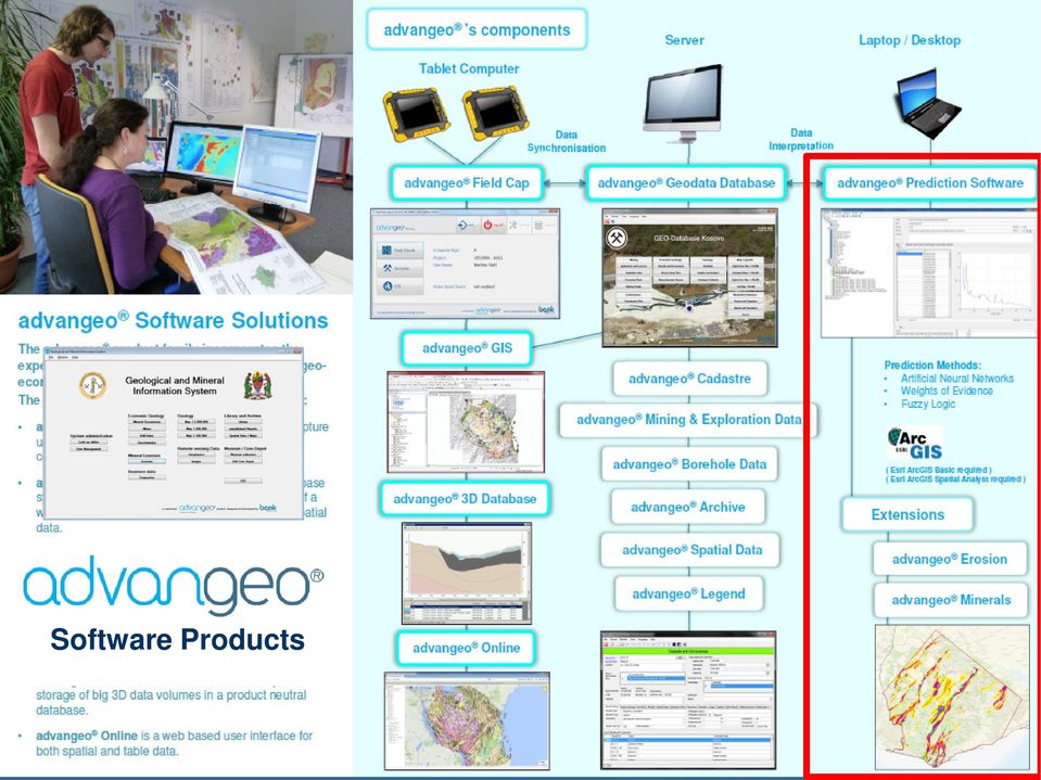
7 Software Products Folie 7

8 gfb ID_GFB GFB_Name GFB_Bemerk gfb_guelt GFB_erh BSA_Gebiete ID_BSG BSG_Name sst_in_gfb sst_in_bsg rf_flstk ID_rf_flstk flstk flstk_bemer Name Ort PLZ Str Tel GFB_erf sst_in_flstk sst ID_sst gfbb_ueber_uta SST_name SST_Nr Dat_ersterh sst_hat_vrw_zst Dat_ersterf vrw_zst UTA Hoch ID_vrw_zst ID_UTA Rechts vrw_zst_bemer UTA_Name HN Dat_erh UTA_Abmess sst_basisbeschr Dat_erf UTA_Beschr_kurz sst_in_uta HNmin HNmax UTA_erh sst_beschr UTA_erf ID_sstbeschr UTA_beschr_lang beschr_kurz Ntzng_ist Ntzng_pln san_arb schaeden ID_san_arb bse san_arb_erh sst_hat_san_arb erh_dat san_arb_erf erf_dat san_arb_beschr sst_hat_sstbeschr foto san_arb_von beschr_lang san_arb_bis san_bed GMIS Tanzania Database Design Look up tables User management Database Management Modules Start form Meta data & files Real data Library Mineral deposits Bore holes Geochem Licenses Collection Drill core depot Geol. Maps, Legends... Spatial data, Maps View Documents View Maps in the GIS Map printing GIS Map printing Folie 8

9 Folie 9 GMIS Tanzania Web Portal View & print documents sst_in_uta sst_hat_san_arb gfbb_ueber_uta sst_in_gfb sst_in_flstk sst_hat_vrw_zst sst_in_bsg sst_hat_sstbeschr sst ID_sst SST_name SST_Nr Dat_ersterh Dat_ersterf Hoch Rechts HN sst_basisbeschr sst_beschr ID_sstbeschr beschr_kurz Ntzng_ist Ntzng_pln schaeden bse erh_dat erf_dat foto beschr_lang san_bed BSA_Gebiete ID_BSG BSG_Name vrw_zst ID_vrw_zst vrw_zst_bemer Dat_erh Dat_erf rf_flstk ID_rf_flstk flstk flstk_bemer Name Ort PLZ Str Tel gfb ID_GFB GFB_Name GFB_Bemerk gfb_guelt GFB_erh GFB_erf UTA ID_UTA UTA_Name UTA_Abmess UTA_Beschr_kurz HNmin HNmax UTA_erh UTA_erf UTA_beschr_lang san_arb ID_san_arb san_arb_erh san_arb_erf san_arb_beschr san_arb_von san_arb_bis Database Database interface sst_in_uta sst_hat_san_arb gfbb_ueber_uta sst_in_gfb sst_in_flstk sst_hat_vrw_zst sst_in_bsg sst_hat_sstbeschr sst ID_sst SST_name SST_Nr Dat_ersterh Dat_ersterf Hoch Rechts HN sst_basisbeschr sst_beschr ID_sstbeschr beschr_kurz Ntzng_ist Ntzng_pln schaeden bse erh_dat erf_dat foto beschr_lang san_bed BSA_Gebiete ID_BSG BSG_Name vrw_zst ID_vrw_zst vrw_zst_bemer Dat_erh Dat_erf rf_flstk ID_rf_flstk flstk flstk_bemer Name Ort PLZ Str Tel gfb ID_GFB GFB_Name GFB_Bemerk gfb_guelt GFB_erh GFB_erf UTA ID_UTA UTA_Name UTA_Abmess UTA_Beschr_kurz HNmin HNmax UTA_erh UTA_erf UTA_beschr_lang san_arb ID_san_arb san_arb_erh san_arb_erf san_arb_beschr san_arb_von san_arb_bis Post GreSQL with PostGIS CMS Web Database replication GeoServer ARCGIS Server SQL server GIS interface Windows application Public web site Interactive maps/ database

10 GMIS Tanzania Public Web Site Folie 10

11 Verified mineral occurrence data: Locations Grades By-products Genetic types Mining conditions, Metallurgy Tailing description Field Data Verification Folie 11

12 The Minerogenic Map is a summarizing document Folie 12

13 Minerogenic Map: accurate mineral occurrence locations Mineral occurrence descriptions, genetic understanding, mineral potential Folie 13

14 Gold in Tanzania Training Data: Location of known greenstone hosted gold occurrences Training Area: Northern Part of the craton Au predictive map Model Input Data: - Geology - Tectonics - Magnetics - Potassium - Uranium - Thorium - Elevation model Folie 14

15 Tanzania Gold Potential Map Folie 15

16 Mineral Predictive Mapping Data sets Metallogenic Models Locations = Known occurrences The expert s knowledge /experience supported by modern information technology Data Analysis and Interpretation Target areas Exploration target map Folie 16

17 Software Products Folie 17
18 Mineral Predictive Mapping Approaches Data driven: Artificial neural networks Random Forests Logistic regression Weights of evidence.. Knowledge driven: Fuzzy logic Ranking Folie 18

19 Predictive Mapping Using Artificial Neural Networks Data sets Metallogenic Models Locations Pre-Processing Extraction of potentially ore controlling features The artificial neuronal network replaces the experts empirical data analysis Validation The predictive map = Exploration target map Folie 19

20 Artificial Neural Networks: The Method Model: Neuron Cell Functionality as a biological neural system Consists of artificial neuron cells Simulation of biological processes of neurons by use of suitable mathematical operations In most cases layer-like configuration of the neurons The Neuron Cell as a Processor Connection between the neurons by weights w Enforce or reduce the level of the input information Are directed, can be trained Input signals Re-computed to a single input information: the propagation function Output signals Activation function computes the output status of a neuron (often used: Sigmoid function) Folie 20

21 Artificial Neural Networks: Principal Setup Network Topology: MLP (Multi Layer Perceptron) Set-up of neurons in layers Direction and degree of connections Amount of hidden layers and neurons Folie 21

22 Artificial Neural Networks: The Training Process Learning Algorithm: Back-Propagation Repeated input of training data Modification of weights w Reduces error between expected and actual output of the network MSE - Curve Folie 22
23 Gold in South-West Ghana Folie 23
24 How to Build a Predictive Model? Definition of Model Accuracy / Resolution and Extent Selection and Harmonization of Source Data Processing of Source Data Preparation of Model Input Data Setting Up and Running of Different Model Scenario Presentation of Final Model Scenario Results Folie 24
25 Study Area & Genetic Model Investigation Area Genetic types of gold deposits Placers Hard rock 2013 Source: Gold Deposits of Ghana, Minerals Commission, Ghana, ROBERT J. GRIFFIS, KWASI BARNING, FRANCIS L. AGEZO, FRED K. AKOSAH, 2002 Gold deposits Source: The Geological Survey Department, Ghana Folie 25
26 How to Build a Predictive Model? Definition of Model Accuracy / Resolution and Extent Selection and Harmonization of Source Data Processing of Source Data Preparation of Model Input Data Setting Up and Running of Different Model Scenario Presentation of Final Model Scenario Results Folie 26
27 Harmonizing Occurrence Data Project database attributes: Exact location Genetic type Host rocks Ressources Size Producer 340 vein/stockwork deposits/occurrences 40 placers 30 unclear (excluded) Folie 27


28 Harmonizing Geological & Tectonic Data Minerals Commission, Griffis Consulting, 2002 GSD, BGR, 2012 Folie 28


29 Processing / Harmonizing Geophysical Data Folie 29
30 How to Build a Predictive Model? Definition of Model Accuracy / Resolution and Extent Selection and Harmonization of Source Data Processing of Source Data Preparation of Model Input Data Setting Up and Running of Different Model Scenario Presentation of Final Model Scenario Results Folie 30
31 Processing of Magnetic Data: Derivatives Magnetic absolute Magnetic Slope What are the preferred magnetic signatures for Au mineralisations? Magnetic Aspect S-N Magnetic Aspect W-E Folie 31
32 Processing of Tectonic Data: Direction / Intersections Tectonics What are the preferred fault directions for Au mineralisations? Junctions of all Faults Faults: direction0-70 JunctionsofFaults: direction 0-70 Folie 32
33 Processing of Tectonic Data: Size Tectonics What are the preferred fault sizes for Au mineralisations? Faults(big > 36km) Faults(small < 14km) Faults(medium km) Folie 33
34 Processing of Geological Data: Rock Units Hardrock What are the preferred host rocks of Au mineralisations? Placers Folie 34
35 How to Build a Predictive Model? Definition of Model Accuracy / Resolution and Extent Selection and Harmonization of Source Data Processing of Source Data Preparation of Model Input Data Setting Up and Running of Different Model Scenario Presentation of Final Model Scenario Results Folie 35
36 Qualitative Model: Setup Input Data / Layers Training Data Weights Hidden Layers Output Layer Weights Result: Probability Known Mineralisations Validation Folie 36
37 Qualitative Models: Gold in Hard Rocks Input Data Large faults Striking direction 5 75 degrees Junctions Small faults Geology Histogram: All data points Histogram: Known occurrences Very clear spatial pattern Prospective zones are small Prospective zones are focused Most of known occurrences are located in high potential areas Low error: approx Error: Folie 37
38 Importance / Significance of Input Data Layers 18 Birimian volcano- 16 sedimentary group Connection Weights after "Garson's Algorithm" Birimian gneisses 14 Mafic 12 dykes 10 8 Birimian volcanicintrusive rocks Magnetics gradient Tectonics junctions Euclidean Distance for Geological Units (Class 1100) Euclidean Distance for Geological Units (Class 3003) Euclidean Distance for Geological Units (Class 3004) Euclidean Distance for Geological Units (Class 3502) Euclidean Distance for Geological Units (Class 3504) Euclidean Distance for Geological Units (Class 3508) Euclidean Distance for Geological Units (Class 3602) Euclidean Distance for Geological Units (Class 3703) Euclidean Distance for Geological Units (Class 3704) Euclidean Distance for Geological Units (Class 3705) Euclidean Distance for Geological Units (Class 3803) Euclidean Distance for Geological Units (Class 99) Magnetics Magnetics Aspect South-North Magnetics Aspect West-East Magnetics Slope Euclidian Distance for Tectonic 5-70 Euclidian Distance for Crossings of Tectonic 5-70 Birimian intrusives Birimian clastic sediments Folie 38
39 Quantitative Models: Gold in Hard Rocks Input Data Magnetics, absolute Magnetics, slope Magnetics, aspect Medium faults Large faults Junctions Geology Reality Current/ past producer Major prospects Prospects Anomalies Prediction Error: 0.06 Folie 39
40 The Most Prospective Targets? Prospects located in areas with a potential of > 0.8 All other prospects Folie 40
41 How to Build a Predictive Model? Definition of Model Accuracy / Resolution and Extent Selection and Harmonization of Source Data Processing of Source Data Preparation of Model Input Data Setting Up and Running of Different Model Scenario Presentation of Final Model Scenario Results Folie 41
42 The Model Accuracy: Kibi Belt 50 meters resolution Exploration sites next slide Folie 42
43 Exploration Lines Near Kibi Folie 43
44 Final Map Product Folie 44
45 Conclusions Neural network based mineral predictive maps: Are data driven Are not biased Are easy to create Organizes any kind of geological data Supports neural network based exploration targeting Fully ESRI GIS and database integrated Folie 45
46 Thank you for your attention More information at Our booth and our web site The SW Ghana Gold low resolution map is available at: W.pdf The Geological and Mineral Information System of Tanzania is available at: We wish to thank our clients, partners and supporters for the excellent co-operation. Folie 46