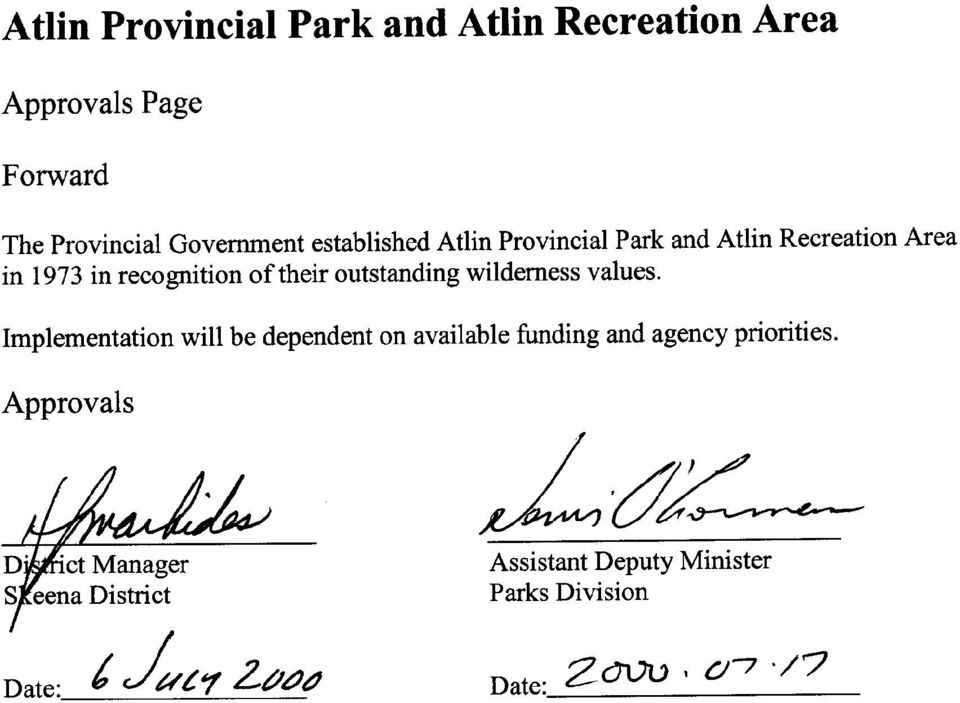
MANAGEMENT DIRECTION STATEMENT
|
|
|
- Magnus McKinney
- 8 years ago
- Views:
Transcription
1 Skeena District MANAGEMENT DIRECTION STATEMENT July 2000 for Atlin Park and Recreation Area Ministry of Environment Lands and Parks BC Parks Division

2
3 Table of Contents I. Introduction A. Purpose of the MDS...1 B. Setting and Context...1 II. Protected Area Attributes A. Conservation...1 B. Recreation and Tourism...2 C. Cultural Heritage...3 D. Significance in the Protected Areas System...4 III. Land Uses, Tenures and Interests A. Access...7 B. Tenures...7 C. Existing Land Use Activities and Facilities...8 D. Adjacent Patterns of Use...8 E. First Nations Interests...8 F. Other Agency Interests...9 G. Private and Public Stakeholder Interests...9 IV. Role of the Protected Area...9 V. Management Commitments and Issues A. Management Direction from Previous Planning...10 B. Management Issues...10 VI. Management Strategy A. Overall...11 B. Priority Management Objectives and Actions...11 C. Consultation and Future Planning...13 D. Zoning...14 Appendix 1 Activity/Use Matrix...16 Figures: Figure 1 Context Map...5 Figure 2 & 3 Park Map & Zoning Map...6,15 i

4 I. Introduction A. Purpose of Management Direction Statements Management Direction Statements provide strategic management direction for all protected areas that do not have a full management plan. MDS do not negate the need for future, more detailed management plans. Management Direction Statements also describe protected area values, management issues and concerns; management strategy focused on immediate priority objectives and strategies; and, directional statements from other planning processes. B. Setting and Context Atlin Provincial Park and Atlin Recreation Area (hereafter collectively called Atlin Park) are located at the south end of Atlin Lake on the eastern slopes of the Coast Range. The name for Atlin Lake is derived from the First Nation word aht-lah meaning big water. The Class A Park, comprises some 232,695 hectares while the Atlin Recreation Area comprises 38,445 hectares. (Figure 1). Atlin Park contains a spectacular variety of physiographic features including Atlin Lake itself with its aquamarine waters, treed shoreline and islands, rounded alpine highlands, tree clad valleys, rugged peaks, vast nunatak- studded glaciers (a nunatak is an isolated mountain peak projecting through a glacier) and unvegetated gravel outwash. Atlin Park lies north of the 59th parallel. Thus, winter is the dominant season with only three to four months averaging over 10 degrees Celsius. The Geology of the park is principally sedimentary and volcanic rocks. Boreal forests at lower elevation give way to subalpine and alpine zones at higher elevations. The town of Atlin, north east of the park, was established with the gold rush of 1898 and became accessible by road in 1950 with the completion of the road linking it with the Alaska Highway. Recent years have seen increasing recreational use of Atlin Park consistent with a worldwide upswing in backcountry tourism. II. Protected Area Attributes A. Conservation serves as a major wilderness park in northwest BC significant representation of the Tahltan Highlands ecosection with minor representation of the Plateau and Boundary Ranges ecosections. contains Boreal White and Black Spruce (BWBSe), Spruce-Willow-Birch (SWB), Alpine Tundra (AT), Engleman Spruce-Subalpine Fir (ESSFxv) and Subboreal Spruce (SBS) biogeoclimatic zones. highest (water level to height of land) island in an inland lake in the world. 1

5 special features include Atlin Lake (the largest natural lake in BC), over eighty islands including Teresa and Copper Islands, portions of the Llewellyn and Williston glaciers and Juneau Icefield, Warm Springs and Sloko Falls. significant mountain goat population and habitat. provincially significant lake trout in Atlin Lake and high fisheries values in most of the smaller lakes and watercourses in the park. several hot springs occur at the northern boundary of the park in the O Donnel River Valley. provides for scientific study including glaciation and natural history. provides opportunities for an interpretation program relating to glacial history and ecology. Wildlife - Mountain goat, Fanin and Stone sheep (summer range), Osbourne caribou, moose, grizzly bear, black bear, blacktail deer, wolf, and fox, beaver, Hoary marmot, and Arctic ground squirrel. Birds - Bonaparte s Gull, Arctic Tern, Common Loon, Pacific Loon, Northern Shrike, Gyr Falcon, Lesser Golden-Plover, Wandering Tatter, Hudsonian, Godwit, Red Necked Phalarop, Smith s Longspur, Snow Bunting, Common Redpol, ducks, snipe, bald eagles, Spruce Grouse, Ptarmigan, swallows, thrushes, sparrows, chickadees, jays and robins. Fish - Lake trout, Round whitefish, Lake Whitefish, Arctic Grayling, Northern Pike. The Conservation Data Centre lists the following rare elements as occurring within Atlin Park: Scientific Name Common Name Prov List Survey Site VERTEBRATES Coregonus sardinella Least Cisco Red Atlin Lake VASCULAR PLANTS Draba lactea Hilky Draba Blue Birch Mountain Epilopium horwemann II SSP Hornemanns Blue Atlin Lake/Sloko Lake willowherb Behringianum Lupus xuschei ukon Lupine Blue Birch Mountain, North Slope Papaver alboroseum Pale Poppy Blue Lower Llewellyn Glacier B. Recreation and Tourism The spectacular setting for Atlin Park provides for a variety of recreation opportunities, primarily focused on Atlin Lake itself and its environs. The park provides opportunities such as motorboating, kayaking, island and lakeshore camping, fishing, hunting, houseboating, scenic and wildlife viewing and photography. It also provides limited backcountry hiking opportunities such as a trail to a viewpoint overlooking the Llewellyn Glacier. Tourism in Atlin, British Columbia, the ancestral home of the Taku River Tlingit First Nation, began with a gold rush and the influx of hundreds of fortune seekers into the Atlin 2

6 area in By 1900, the area contained eight to ten thousand prospectors. Five years later, the gold rush waned as thousands left the region. The impact of these prospectors and miners, however, continues to this day. By 1900, engineers and construction gangs had developed Atlin's transportation links to the outside world. Travelers no longer climbed the Chilkoot Trail from Skagway and Dyea in Alaska. Now prospectors could travel by train to Carcross, paddlewheel boat to Taku City, tram to Scotia Bay and finally another boat across to Atlin. Thousands of tourists used this White Pass and ukon route to the interior. By the mid-1920s over 9,000 visitors a year chose this route for a vacation. Atlin's fist chapter of tourism ended suddenly when fuel prices rose and the Great Depression hit the north. The White Pass Railway opted to close its Atlin line in Tourism began again in 1949 with construction of the Atlin road, linking the community with the Alaska Highway. Atlin remained quiet through the 1950s and 1960s. But visitor numbers steadily climbed in the 1970s as mining and tourism increased in the area and people sought alternative lifestyles. Tourism continues to grow in the Atlin area. This economic activity includes a wide array of services and clientele including adventure tourism, wilderness recreation, motor boating, kayaking, winter heli-skiing, big game guide outfitting, hunting and recreation vehicle traffic. To date, recreation use has been primarily regionally based from Atlin and Whitehorse. Alaska Highway travelers and international tourists are making increasing use of the Atlin Park and Recreation Area. The National Geographic magazine featured the park in a recent article. Kayaking, houseboating and winter activities are gaining popularity. A number of boat mooring sites and camping areas exist in the park, some with backcountry style toilets (Figure 2). The park also contains several unmaintained hiking trails (trail from Atlin Lake to Llewellyn Glacier and trail from Atlin Lake into Sloko Mountain Range). The historic Telegraph Trail was established along the Pike River and Atlin Lake with many sections overgrown and difficult to find. The area within one kilometer of Atlin Lake is closed to hunting. The remainder of the park is closed for caribou and sheep, with limited entry hunting for goats and grizzly bear, and regulated hunting for other species. Recently two small filming projects took place in the park. C. Cultural Heritage Approximately twenty-two archaeological sites have been identified within the park boundaries on Copper Island and some of the other islands especially around the Second Narrows. The park is within the traditional territory of the Taku River Tlingit First Nation. Remnants of the historic Telegraph Trail and a line cabin are found within the park boundaries. While the gold rush history is centered primarily in areas adjacent to the park, this history provides a relevant context for the park itself. 3

7 D. Significance in the the Protected Areas System Atlin Park constitutes an outstanding wilderness park in BC s protected areas system. As noted, the park: comprises a combination of natural, cultural heritage and wilderness backcountry land and water recreation values that makes this park and recreation area among the most significant large protected areas in the system; presents for resident, national and international visitors wilderness recreation tourism opportunities on a scale and quality rivaled only by a few BC provincial protected areas including the Bowron Lake-Cariboo Mountains-Wells Gray parks complex, Garibaldi Park, Northern Rocky Mountains Park, Spatisizi-Tatlatui parks complex, Strathcona Park, Tatshenshini Alsek Park, Ts'il-os Park, and Tweedsmuir Park and Recreation Area. represents the Tahltan Highlands Ecosection and five biogeoclimactic zones, contains a spectacular variety of physiographic features, contains a portion of the largest natural lake in BC with over 80 islands and aquamarine waters, contains provincially significant lake trout and mountain goat populations, the Cathedral and Llewellyn Glacier are the sites for internationally important scientific glacialogy research; and contains significant cultural heritage resources. 4

8 Map 1 (Atlin MDS) Atlin Provincial Park and Recreation Area Regional Location Atlin Dease Lake Legend Skeena Parks District Atlin Park Road - Trunk Prince Rupert Terrace Smithers Rivers and Lakes QCI Coastline - Definite Kilometers British Columbia 1: Prince George # # Vancouver

9 Figure 2 - Park Map Map available as a separate file for download due to the large file size (1.2 MB) 6

10 Ill. Land Uses, Tenures and Interests A. Access No statused roads enter the park. Access is presently via the road on the east side of Atlin Lake to Warm Bay, or by boat or aircraft to the backcountry. B. Tenures No fee simple land exists within the park. The Recreation Area has moderate to high mineral potential for gold, silver, copper, lead, zinc, nickel, molybdenum and tungsten. Mineral Claims - The recreation area is designated under the Mineral Tenure Act - See OIC 379/89. Mineral exploration activity occurred in the Hoboe Lake Area from 1899 to 1910 with discovery of precious metals and porphyry style mineralization. Mineral exploration occured in the South Williston Glacier Area from 1966 to Cominco Ltd owns Crown Granted mineral claims on D.L. 304 and 305 Cassiar District. All mineral tenures previously held in the recreation area, except the above noted Crown granted claims, have been fofeited. The recreation area is now designated as a no staking reserve, which precludes future mineral exploration activity until a final land use designation is made. Water Rights - Reserve in favor of Water Rights Branch below the elevation of 2225' cancelled Aug. 6, 1987, File # Park Use Permits as of July 1998 SK Foundation Glacier & Environmental Research SK Fernie,Garth - Trapping SK MOF - Structure SK Antilla, Guy - Big Game and Angling Guiding SK RCMP - Structure SK Discovery Helicopters - Transportation SK McKenzie, Aaron - Angling Guiding SK Cascade Interlink Aero - General Rec. Guiding SK ukon Inc. - General Recreational Guiding SK McGee, Caroline - General Rrecreational Guiding SK Atlin Center for the Arts - General Recreational Guiding SK Gordon, Louise - General Recreational Guiding SK Atlin Wilderness Exploration - General Recreational Guiding SK Norseman Adventures Ltd. Houseboat Tours and Recreational Guiding Rights-of-Way Telegraph Trail 100 feet wide along the Dominion Telegraph Line, and extending for a distance of 50 feet on each side of the Line of telegraph poles (see OIC 498/08) 1989 Campground Feasibility Study A study was completed by J.S. Peepre and Associates in 1989 assessing 17 possible sites. Some were north of Atlin, outside the park, and some south inside 7

11 the park. Three (one inside the park) were recommended as very suitable, with some initial land status research completed. C. Existing Land Use Activities and Facilities Existing land use activities are noted in the earlier sections. Facilities: Cabin at Pillman Creek - unknown status. Documentation indicates cabin was erected under a placer mining licence but without proper approval. Several letters requested removal of cabin. One historical telegraph line cabin at Pike Bay. Several trails. Historic remnants of telegraph trail, trail to Llewellyn Glacier, trail to Sloko lake. Research camps at The Cathedral and Llewellyn Glacier owned by the Foundation for Glacier and Environmental Research. (Small buildings and toilet facilities) Repeater sites located on Teresa Island. A number of marine mooring sites and backcountry camping areas on Atlin Lake. Tent frame structure held by RCMP on Atlin Lake. D. Adjacent Patterns of Use There is historic and modern mining surrounding Atlin Park. Placer mining is currently taking place in several creeks that drain into Atlin Lake. American Boullion had requested permission to run a road through a part of the Park to access an ore body near the Tulsequah Glacier. Currently, Redfern Mines are contemplating reopening an old Cominco mine near the Taku River. There is currently a heliski operation just outside the Recreation Area, operated by Klondike Helimajic Inc. The Foundation for Glacier and Environmental Research may have structures for temporary camps outside the park. B.C. Forest Service has a campsite on Atlin Lake at Warm Bay. There is currently tourism, guided fishing, guided hunting, guided kayaking, and other recreational activities taking place within and outside park boundaries. E. First Nations Interests The Taku River Tlingit First Nation has been approached to participate in the process for preparing this plan. Initial response indicates that the First Nation: asserts aboriginal rights and title to the park and that the provincial park status needs to be validated through the Treaty process. maintains camps, hunting areas, fishing areas, and major use sites within the park. is interested in a co-management agreement and a cooperative working relationship regarding the future developement of the park area. is interested in sharing information on traditional use currently being assembled. 8

12 is interested in developing accurate information for the park regarding to the Taku people. F. Other Agency Interests The Ministry of Mines and Petroleum Resouces has an interest in the Recreation Area where there is historic staking of claims. B.C. Environment has interests in the park s wildlife and fish. They have done creel surveys, and there have been mountain goat inventories, including proposals for transplanting goats. G. Private and Public Stakeholder Interests First Nations Hikers, backcountry users Snowmobilers Hunting and angling guides Fishers, hunters Commercial Recreation Operators Companies offering air access into the park Community of Atlin IV. Role of the Atlin Park and Recreation Area Atlin Park and Recreation Area play a major conservation role in the BC Protected Areas System. The park and recreation area satisfy the Protected Areas Strategy goal of representativeness as they protect a significant portion of the Tahltan Highlands Ecosection and smaller portions of the Teslin Plateau and Boundary Ranges ecosections. Atlin Park and Recreation Area also satisfy the Protected Areas Strategy goal of protecting special natural features, cultural heritage and recreation features. This latter role is exemplified in the conservation of the Llewellyn Glacier, Sloko River waterfall, vulnerable mountain goat populations, a portion of the Collins overland telegraph trail and archaeological sites. Atlin Park and Recreation Area also serves the role of protecting and presenting outstanding outdoor recreation features, values and opportunities. This park and recreation area satisfies the four BC Parks recreation goals. Tourism travel, holiday destination and backcountry recreation opportunities are of primary importance. A secondary role is the opportunity in the park and recreation area for Atlin residents to enjoy local recreation activities. Finally, the park and recreation area provide a special secondary role of education and scientific research because of the international glacialogical studies occurring in the park. 9

13 V. Management Commitments and Issues A. Management Direction from Previous Planning No known regional or sub regional land use planning exists over the park area or adjacent areas. A Land and Resource Management Plan for the Atlin/Taku area is currently under active consideration by the Provincial Government and may commence shortly. An Interim Policy Statement for Atlin Park was prepared in This statement, while still relevant in some respects, does not provide the clarity of direction to deal with currently emerging issues. An Annual Management Plan has been prepared for the park in recent years. A Fire Plan has been prepared for the park. B. Management Issues Protection of Values damage to the park s environment caused by recreation and commercial use, and unpermitted and uncontrolled uses. presence of forest disease and pest damage in the park s forests as indicated by the large numbers of dead trees in the park. decrease in mountain goat population in the Teresa Island and Torres Channel areas of the park. decline of sheep population in the Sloko Range reduction in the size and numbers (in heavily fished areas such as the Second Narrows) of Lake trout in Atlin Lake attributed to increasing angler pressure. threat to the survival of wildlife populations wintering in the park caused by increasing outdoor winter recreation activities and heliskiing in adjacent areas. Visitor Service demand for some enhancement of facilities for picnicking and camping in the park. some local demand for trail development lack of statistical information on park use and visitor satisfaction Other increasing demand for recreational, winter and commercial activities increasing applications for commercial permits little monitoring and enforcement by B.C. Parks staff. desire for greater involvement by the Taku River Tlingit First Nation and the community of Atlin in managing the park. need to consider upgrading the Recreation Area to full Class A Park status. limited information on Taku River Tlinglit use in the park (past and present) 10

14 VI. Management Strategy A. Overall Atlin Park will be managed as a major wilderness park in BC s protected areas system. The overall objective is to preserve the park s fish and wildlife, natural processes, cultural features, spectacular features and the wilderness character. A variety of recreation, education, scientific and cultural uses will be permitted consistent with the wilderness nature of the park (see table 1). Uses not noted on table 1, require prior approval by BC Parks. Where existing or proposed human activity threatens ecological integrity, or has a potential impact on fish and wildlife, natural processes, cultural features, spectacular features or wilderness character, use will be limited or not permitted. If in doubt, a proposed use will be rejected based on the premise that a conservative approach will best protect the park values for future generations. A case in point is ongoing pressure to permit heliskiing use in the park and recreation area. Heliskiing use has potential to negatively impact on the mountain goat population. Helicopters can disturb mountain goats by eliciting a predator type escape response, breaking down social groups, resulting in injury or death and reducing kid survival. These effects could be significant in the harsh winter season in the Atlin area where temperatures are extremely low, snow is deep and food sources for mountain goats difficult to find. Any application to permit heliskiing will be closely evaluated to ensure that the use does not compromise park values, particularly goat populations and the wilderness environment. Uses that can occur elsewhere will be directed to locate outside the Park. For example, such uses may include provision of services in the adjacent community of Atlin, large motor vessels or commercial ventures more suited to other areas in Northern BC and the ukon, or using the park as a staging area for recreational activities outside the park. Traditional sustenance, medicinal and ceremonial uses by the Taku River Tlingit First Nations will continue to be recognized as an aboriginal right subject to conservation and public safety. B. Priority Management Objectives and Strategies 1. Objective: protect the park s biological diversity and ecological values with special attention focused on mountain goat, sheep, lake trout and forest cover. Strategies: work with the local Conservation Officer, Fish and Wildlife staff, Department of Fisheries and Oceans and licensed guides staff to improve inventory and assess populations of mountain goat, sheep and lake trout species in the park e.g. mountain goat surveys every 3-5 years.; develop management solutions and prescriptions to any identified problems concerning mountain goat, sheep and lake trout species which may include but are not limited to motorized access restrictions, maintenance of conservative harvest levels, further hunting restrictions and reduced limited entry harvest levels, angler restrictions, and reintroduction of sheep or goat populations in specific areas; 11

15 work with Ministry of Forests to determine the extent of forest disease and pest problems in the park and recreation area - consider biannual balsam bark beetle surveys; develop management solutions and prescriptions to any identified forest health problems which may include but not be limited to monitoring of bark beetle outbreaks in the park and recreation area; and update the Fire Management Plan for the park. 2. Objective: manage for current use levels for outdoor recreation, cultural heritage, education and scientific research use in the park, and for a modest expansion of use. Activities that rely on non motorized access will be given priority. Total commercial use will be allowed to expand by no more 300-user days over year 2000 permitted use levels prior to the full management plan for the park being approved. Strategies: Monitor existing levels of use and impacts. - e.g. field inspections of lakeshore campsites and other area during high use periods and completion of impact assessments on Atlin Lake camping sites. If considered necessary, implement strategies to limit impacts on specific sites (e.g. implement no trace camping, camping in designated sites only, establish limits of acceptable change/use, close specific camping sites where impacts are significant). Place additional backcountry toilets in high use areas and signage if necessary. Establish permitted use levels for all commercial operators. e.g. number of trips, number of guests. Consider request for proposals for five-year permits to allocate commercial recreation opportunities and establish maximum user days for all commercial permits. Assess need and feasibility of upgrading existing trail to Llewellyn Glacier, Sloko Lake, and establishing a new trail on Teresa Island (including bear hazard assessments.) Consider expansion of existing commercial operators or establishment of new commercial operators (e.g. heliskiing) only where the use is consistent with the overall management strategy for Atlin Park i.e. will not threaten or risk ecological integrity, natural processes, or the wilderness character of Atlin Park. 3. Objective: Establish and maintain enhanced monitoring of park values and use. Strategies: Establish stronger B.C. Parks presence, e.g. field inspections, meetings in community. investigate feasibility of establishing volunteer warden program with residents of Atlin. work in cooperation with the local Conservation Officer, RCMP and Government Agent 4. Objective: Undertake increased communication and consultation with the community of Atlin. Strategies: consult with community organizations such as the Atlin Planning Commission, Atlin Board of Trade etc. (e.g. on any new or expanded uses in the park.) 12

16 establish semi-annual meetings in the community to provide updates on activities and discuss issues/concerns. 5. Objective: Undertake increased consultation and cooperation with the Taku River Tlingit First Nation (TRTFN) and ensure that traditional uses are recognized and accommodated. Strategies: work with the TRTFN to identify interests, traditional uses, and planned activities in the park. establish a formal protocol with TRTFN to facilitate increased First Nation involvement in the stewardship and protection of the park. work with the First Nation to develop management strategies for sites that have special cultural and spiritual significance work with the TRTFN to develop improved information for the public regarding First Nations and the park. 6. Objective: Establish appropriate communications and extension services for Atlin Park. Strategies: update park brochure and signage to reflect current management direction and First Nation use and interests. consider other mechanisms to inform park users given its remote location, lack of services, and lack of permanent B.C. Parks presence. 7. Objective: Support upgrading of the Recreation Area to a Class A Park. Strategies: develop technical analysis required to support the planning process lay groundwork for public and First Nations support to upgrade the Recreation Area participate in any strategic land use planning processes undertaken by the province (e.g. LRMP) which could lead to upgrade to Class A Park status. if a land use process is not likely to commence in the near future investigate the possibility of upgrading the status of the recreation area in the next 1-2 years on an ad hoc basis. C. Consultation and Future Planning During preparation of this management direction statement the following consultation activities were undertaken meetings with permit holders a public open house in Atlin questionnaire mail-out to every household in Atlin several initial meetings with Taku River Tlingit First Nation representatives. Overall a number of key themes emerged in public comment: the wilderness character of the park needs to be maintained with limited backcountry type facilities; limits may need to be established in the future particularly for commercial uses; protection of the area s wildlife is very important; 13

17 there needs to be more involvement of the community of Atlin in managing the park (e.g. volunteer wardens); there needs to be a greater presence by BC Parks including regular patrols of lakeshore camping sites. Comments from the Taku River Tlingit First Nations are noted in the section on First Nation Interests. Given the size and importance of Atlin Park in the Protected Areas System, preparation of a full management plan should be undertaken as soon as resources in B.C. Parks permit. Unfortunately this will not likely occur for 3-5 years given other higher priority planning projects. In the interim, this Management Direction Statement will provide needed direction. As noted earlier, consultation will continue with The Taku River Tlingit First Nation, community groups and permit holders on planning and management for Atlin Park. The priority for preparing a management plan for Atlin Park and Recreation Area is ranked as high. D. Zoning B.C. Parks has established a five category zoning system for protected areas ranging from intensive recreation to wilderness conservation. Each zone prescribes a number of criteria s such as objective, use level, and access. The park is divided into two zones: Atlin Lake is zoned as natural environment; the remainder of the Park is zoned as wilderness recreation (Figure 3). Consideration may be given to establish a wilderness recreation zone on a portion of Atlin Lake itself (possibly surrounding a group of small islands) to provide for a non-motorized area for wilderness kayaking and nature appreciation. The objective of the natural environment zone is to protect scenic values and to provide for backcountry recreation opportunities in a largely undisturbed natural environment. Use of powerboats and snowmobiles is currently permitted on Atlin Lake. The objective of the wilderness recreation zone is to protect the remote undisturbed natural landscape and to provide unassisted backcountry recreation opportunities dependent on a pristine environment where no motorized activities will be allowed except air access for drop off only. Recreation activities such as hiking, backpacking, kayaking, nature appreciation, fishing, wildlife viewing and cross-country skiing are permitted throughout the park. Hunting, fishing and trapping are permitted in certain areas, and under specific conditions. (See annual hunting and fishing regulations). 14

18 Figure 3 - Zoning Map Map Unavailable 15

19 Appendix 1 Activity/Use Matrix for Atlin Park and Recreation Area Activity/Use/Facility Acceptable Uses First Nations Aboriginal Rights Camping (designated sites) - user maintained Camping (non designated sites) - no trace camping required Backpacking Nature appreciation and education/wildlife viewing/ photography Non motorized water access -canoeing not recommended on Atlin Lake Motorized Water Access - subject to zoning and limits on size and number Aircraft Access - for drop off and high level sightseeing Hunting - subject to regulations Trapping - existing trappers only with valid licenses Horse Use/ Pack Animals - subject to prior approval N 1 Guide Outfitting (hunting) - existing licensed guides only Guide Outfitting (fishing) - licensed guides only Guide Outfitting (backcountry) - licensed guides only Cross Country Skiing Snowmobiling - Atlin Lake only Scientific Research - permit required Commercial Filming - permit required Fire Management - subject to fire plan Backcountry Huts N 1 Facilities for commercial recreation N Recreational Gold Panning/Rock Hounding N Mineral Exploration N Cat-Assisted Skiing/Ski hills N Heliskiing M Grazing (domestic livestock) N Utility corridors N Communication sites -exception for RCMP repeater N 2 Water Control Structures N 1 Fish Stocking Enhancement N 1 Road Access N Off-road Access motorized/mechanized N Forest Insect/Disease Control N 1 = allowed subject to conditions identified in the management direction statement or management plan M = may be permitted if compatible with protected area objectives N = not allowed N 1 = allowed for express management purposes only N 2 = present and allowed to continue, but not normally allowed 16
 - existing licensed guides only Guide Outfitting (fishing) - licensed guides only Guide Outfitting")
MANAGEMENT DIRECTION STATEMENT May, 1999
 Kootenay District AAGEET DIRECTIO STATEET ay, 1999 for Akamina-Kishenina Provincial Park inistry of Environment Lands and Parks BC Parks Division Table of Contents I. Introduction A. Setting and Context...1
MANAGEMENT PLAN. for Stikine Country Protected Areas. November 2003
 MANAGEMENT PLAN November 2003 for Stikine Country Protected Areas Mount Edziza Provincial Park Mount Edziza Protected Area (Proposed) Stikine River Provincial Park Spatsizi Plateau Wilderness Provincial
MAQUINNA PROVINCIAL PARK
 MAQUINNA PROVINCIAL PARK PURPOSE STATEMENT AND ZONING PLAN February 2003 MAQUINNA PROVINCIAL PARK Purpose Statement and Zoning Plan Primary Role The primary role of Maquinna Provincial Park is to protect
Appendix I: Recreation and Visitor Services Market Analysis for the Kobuk-Seward Peninsula Planning Area
 Appendix I: Recreation and Visitor Services Market Analysis for the Kobuk-Seward Peninsula Planning Area A. Introduction...I-3 B. Salmon Lake/Kigluaik SRMA (Alternatives C and D)...I-4 C. Squirrel River
Framework Agreement Between the Taku River Tlingit First Nation and the Province of British Columbia
 Framework Agreement Between the Taku River Tlingit First Nation and the Province of British Columbia FOR SHARED DECISION MAKING RESPECTING LAND USE AND WILDLIFE MANAGEMENT MARCH 2008 FRAMEWORK AGREEMENT
Marchand Provincial Park. Draft Management Plan
 Marchand Provincial Park Draft Management Plan Marchand Provincial Park Draft Management Plan Table of Contents 1. Introduction... 3 2. Park History... 3 3. Park Attributes... 4 3.1 Natural... 4 3.2 Recreational...
Fishing, Hunting & Gathering The Rights and Responsibilities of First Nations People in Manitoba
 Fishing, Hunting & Gathering The Rights and Responsibilities of First Nations People in Manitoba First Nations people have always had a special relationship with the natural life forms that the land provides
Revising the Nantahala and Pisgah Land Management Plan Preliminary Need to Change the Existing Land Management Plan
 Revising the Nantahala and Pisgah Land Management Plan Preliminary Need to Change the Existing Land Management Plan Throughout the Plan 1. There is a fundamental need for the revised plan to address how
Newsletter Jumbo Glacier Alpine Resort Proposal
 Newsletter Jumbo Glacier Alpine Resort Proposal August 1995 - Number 1 - Environmental Assessment Office Province of British Columbia The Jumbo Glacier Alpine Resort Proposal Pheidias Project Management
GORDON BAY PROVINCIAL PARK MASTER PLAN
 GORDON BAY PROVINCIAL PARK MASTER PLAN November, 1995 Southern Vancouver Island District i GORDON BAY PROVINCIAL PARK MASTER PLAN November, 1995 ii iii TABLE OF CONTENTS PLAN HIGHLIGHTS...-i- Section One:
Trout Lake Conservation Reserve (C2334) Resource Management Plan
 Resource Management Plan") Trout Lake Conservation Reserve (C2334) Resource Management Plan Ministry of Natural Resources Red Lake District November 2005 TABLE OF CONTENTS 1. MISSION STATEMENT 4 1.1 Anishinaape History on Trout
Trout Lake Conservation Reserve (C2334) Resource Management Plan Ministry of Natural Resources Red Lake District November 2005 TABLE OF CONTENTS 1. MISSION STATEMENT 4 1.1 Anishinaape History on Trout
WELLS GRAY PARK MASTER PLAN. February, 1986
 2-2-4-1-27 WELLS GRAY PARK MASTER PLAN February, 1986 Ministry of Lands Parks & Housing Parks & Outdoor Recreation Div. i TABLE OF CONTENTS PLAN HIGHLIGHTS PLAN ORGANIZATION SECTION 1 - PARK ROLE 1 1.1
MANAGEMENT PLAN November, 2004
 MANAGEMENT PLAN November, 2004 for E. C. Manning Provincial Park and Cascade Recreation Area Ministry of Environment Environmental Stewardship Division E. C. Manning Provincial Park and Cascade Recreation
Protected Area Categories and Management Objectives
 Protected Area Categories and Management Objectives A protected area is defined as: An area of land and/or sea especially dedicated to the protection and maintenance of biological diversity, and of natural
Visitor management strategy
 Visitor management strategy Introduction Protected areas attract people. Sometimes the protected area management is glad about people who are interested in their work and activities, sometimes protected
NEZ PERCE-CLEARWATER FORESTS
 United States Department of Agriculture Forest Service NEZ PERCE-CLEARWATER FORESTS Fish Creek Meadows A Year-Round Playground For Idaho and the Northwest Fish Creek Meadows Year-round Recreation For Everyone
Ruby Creek Molybdenum Project Monitoring Plan for East Atlin Woodland Caribou
 Monitoring Plan for East Atlin Woodland Caribou PREFACE This document has been provided in draft to the Ruby Creek Working Group Wildlife Sub-Committee (Wildlife Working Group) for discussion purposes
The Nature Conservancy Offering Protected Lands for Sale in the Adirondacks Sustainable Forestry to Continue
 News release For immediate release August 21, 2008 Contact: Connie Prickett, (518) 576-2082 x162, cprickett@tnc.org The Nature Conservancy Offering Protected Lands for Sale in the Adirondacks Sustainable
TERMS OF REFERENCE RIVERSIDE FOREST PRODUCTS LIMITED SUSTAINABLE TOTAL RESOURCE MANAGEMENT PROJECT
 TERMS OF REFERENCE RIVERSIDE FOREST PRODUCTS LIMITED SUSTAINABLE TOTAL RESOURCE MANAGEMENT PROJECT 1. PURPOSE The purpose of the Riverside Forest Products Limited (Riverside) Project (the Project) is to
APPENDIX B: TRAIL DEVELOPMENT AND MANAGEMENT STANDARDS
 APPENDIX B: TRAIL DEVELOPMENT AND MANAGEMENT STANDARDS This section provides guidance on a variety of trail issues for planners and developers of the Ice Age NST across the state. It also provides introductory
Off-road Vehicle Regulation. discussion paper
 Off-road Vehicle Regulation discussion paper Yukon is developing a set of regulations to assist in creating the process and tools that will enable us to manage potential environmental damage caused by
High Conservation Value Forests 3.1. Old Growth Forests. Management & Monitoring Framework
 High Conservation Value Forests 3.1 Old Growth Forests Management & Monitoring Framework HCV 3: Forest areas that are in or contain rare, threatened or endangered ecosystems. HCVF 3.1 Old Growth Areas
SANTA BARBARA COUNTY COMPREHENSIVE PLAN LOMPOC AREA
 SANTA BARBARA COUNTY COMPREHENSIVE PLAN LOMPOC AREA A. LAND USE ELEMENT INTERPRETIVE GUIDELINES B. COMMUNITY BENEFITS C. COUNTY ACTION ITEMS Adopted by the Board of Supervisors November 9, 1999 A. Santa
The Greater Sage-Grouse:
 The Greater Sage-Grouse: Hunter opinions regarding potential conservation strategies in Colorado For: National Wildlife Federation October 30, 2014 PO Box 6435 Fernandina Beach, FL 32035 Tel (904) 277-9765
Kamchatka. Russian land of bears and fire
 Kamchatka Russian land of bears and fire A land of spectacular wild beauty, with dozens of smoking volcanoes Rivers, creeks and lakes crowded with salmons. Forests of birch and conifer and in another part
AN INITIATIVE TO IMPROVE
 L OW E R C A R M E L R I V E R A N D L AG O O N F L O O D P L A I N R E S TO R AT I O N A N D E N H A N C E M E N T P R O J E C T AN INITIATIVE TO IMPROVE FLOOD PROTECTION RESTORE AND PROTECT RIPARIAN
MAINTAINING BIOLOGICAL DIVERSITY
 APPROACHES TO MAINTAINING BIOLOGICAL DIVERSITY IN BRITISH COLUMBIA S FORESTS An Introduction for Resource Managers The Centre for Applied Conservation Biology University of British Columbia Province of
Ministry of Lands, Parks and Housing Parks and Outdoor Recreation Division South Coast Region BRIDAL VEIL FALLS PARK MASTER PLAN
 Ministry of Lands, Parks and Housing Parks and Outdoor Recreation Division South Coast Region BRIDAL VEIL FALLS PARK MASTER PLAN February, 1984 To: Mr. C. J. Velay SOUTH COAST REGION Director, Park Programs
First Annual Centennial Strategy for. Yucca House National Monument
 First Annual Centennial Strategy for Yucca House National Monument August 2007 Year: 2007 Vision Statement Yucca House National Monument was set aside in 1919 to preserve an unexcavated Ancestral Puebloan
BI-POLE III - KEEWATINOOW CONVERTER STATION PROJECT Construction Access Management Plan
 2013 BI-POLE III - KEEWATINOOW CONVERTER STATION PROJECT Construction Access Management Plan Manitoba Hydro Manitoba Hydro 9/9/2013 BI-POLE III KEEWATINOOW CONVERTER STATION PROJECT Construction Access
STANDARDS FOR RANGELAND HEALTH ASSESSMENT FOR SAGEHEN ALLOTMENT #0208
 STANDARDS FOR RANGELAND HEALTH ASSESSMENT FOR SAGEHEN ALLOTMENT #0208 RANGELAND HEALTH STANDARDS - ASSESSMENT SAGEHEN ALLOTMENT #0208 STANDARD 1 - UPLAND WATERSHED This standard is being met on the allotment.
Finance, Mining & Sustainability. The Gamsberg Zinc Project South Africa
 Finance, Mining & Sustainability The Gamsberg Zinc Project South Africa Project Summary Discovered in 1971 Anglo American purchased 33% interest in 1974 and increased interest to 100% in 1998 Feasibility
U.S. Fish and Wildlife Service CHARLES M. RUSSELL NWR Outreach Notice
 U.S. Fish and Wildlife Service CHARLES M. RUSSELL NWR Outreach Notice Supervisory Range Technician (Fire) GS-0455-06/07 Firefighter Location JORDAN, MONTANA The U.S. Fish & Wildlife Region 6 Charles M.
Summary of the Second College Grant Master Plan
 1 Summary of the Second College Grant Master Plan Dartmouth College owns and manages 27,000 acres of woodland in the Northern Forest region of New Hampshire, near Erroll, New Hampshire and the Maine state
01 Mission & Vision 02 Pristine & Accessible. 04 Overview 06 Architectural Plans 10 Site Photography 14 DL 7349 Photography
 01 Mission & Vision 02 Pristine & Accessible 04 Overview 06 Architectural Plans 10 Site Photography 14 DL 7349 Photography 28 Atlin 30 What the Local Residents Are Saying 32 Activities 34 Arts And Cultural
SUSTAINABLE FOREST MANAGEMENT PLAN SKEENA BUSINESS AREA
 SUSTAINABLE FOREST MANAGEMENT PLAN SKEENA BUSINESS AREA NORTH COAST, KALUM AND SKEENA-STIKINE OPERATIONS Approved: Norman H. Parry, Timber Sales Manager Date: September 5, 2007 Table of Contents 1 INTRODUCTION
Legislative Counsel s Digest: Sections 1-8 Section 9
 Assembly Bill No. 352 Assemblymen Mortenson, Segerblom; Bobzien, Claborn, Horne, Kihuen, Kirkpatrick, Manendo, Munford, Ohrenschall, Parnell, Pierce, Smith and Spiegel CHAPTER... AN ACT relating to the
3.0 COST OF WILDLIFE-RELATED MOTOR VEHICLE ACCIDENTS
 3.0 COST OF WILDLIFE-RELATED MOTOR VEHICLE ACCIDENTS 3.1 Wildlife-related Motor Vehicle Accidents The cost of wildlife-related motor vehicle accidents to the residents of British Columbia is substantial.
ANAGEMENT LAN. for Sasquatch Provincial Park JUNE, 2002. Ministry of Water, Land and Air Protection Environmental Stewardship Division
 M ANAGEMENT P LAN JUNE, 2002 for Sasquatch Provincial Park Ministry of Water, Land and Air Protection Environmental Stewardship Division Table of Contents Introduction...... 1 The Management Planning
Examination of Traditional Use of Bingo (Spy) Hill and Potential Mitigation
 Hill and Potential Mitigation") Examination of Traditional Use of Bingo (Spy) Hill and Potential Mitigation 1.0 BACKGROUND Bingo Hill (also known as Spy Hill) is located approximately 270 m within the Star feasibility study open pit
Examination of Traditional Use of Bingo (Spy) Hill and Potential Mitigation 1.0 BACKGROUND Bingo Hill (also known as Spy Hill) is located approximately 270 m within the Star feasibility study open pit
2016 Outlook and Management -Pre-season outlook / expectations and early indications - General overview of in-season management approach
 Salmon Briefing 2016 Outlook and Management -Pre-season outlook / expectations and early indications - General overview of in-season management approach Pacific Salmon Species Size and age at return varies
Climate, Vegetation, and Landforms
 Climate, Vegetation, and Landforms Definitions Climate is the average weather of a place over many years Geographers discuss five broad types of climates Moderate, dry, tropical, continental, polar Vegetation:
Wildlife Accident Reporting System (WARS) 1983-2002 Integrating Data into Transportation Planning
 1983-2002 Integrating Data into Transportation Planning") Wildlife Accident Reporting System (WARS) 1983-2002 Integrating Data into Transportation Planning Leonard Sielecki, M.Sc., R.P.Bio, MCIP British Columbia Ministry of Transportation Rockies Wildlife Crossing
Wildlife Accident Reporting System (WARS) 1983-2002 Integrating Data into Transportation Planning Leonard Sielecki, M.Sc., R.P.Bio, MCIP British Columbia Ministry of Transportation Rockies Wildlife Crossing
CYPRESS PROVINCIAL PARK MASTER PLAN
 CYPRESS PROVINCIAL PARK MASTER PLAN A VISION FOR CYPRESS PROVINCIAL PARK... it is the vision that Cypress Park will exemplify BC Parks and British Columbia s commitment to park stewardship in conservation,
Past and Current Research on Natural Resource Issues in the Blue Mountains
 Past and Current Research on Natural Resource Issues in the Blue Mountains Recreation, Hunting, Access Livestock Production (and Wild Ungulate Ecology) Restoration Timber Harvest, Production Biodiversity,
CORPORATE POLICY STATEMENT NO. 12 MANAGEMENT OF PEST ANIMALS
 1. OBJECTIVE CORPORATE POLICY STATEMENT NO. 12 MANAGEMENT OF PEST ANIMALS August 2015 To provide direction and guidance for the management of pest animals on lands and waters managed by the Department
Background Information: The Mamquam River Floodplain Restoration Project
 Background Information: The Mamquam River Floodplain Restoration Project The Mamquam River Floodplain Restoration project is being undertaken in partnership with the Squamish River Watershed Society, Fisheries
PART FOUR Vision, Objectives and Policies
 PART FOUR Vision, Objectives and Policies VISION: To enhance the reserve as a Botanic Garden through improved plant collections and provide learning and passive recreation opportunities. 4.1 Plant Collections
Decision Support Tools for the Columbia Basin from the BC Breeding Bird Atlas Final Report 2013-14. Project # W-F14-18
 Decision Support Tools for the Columbia Basin from the BC Breeding Bird Atlas Final Report 2013-14 Project # W-F14-18 Prepared by Bird Studies Canada with financial support of the Fish and Wildlife Compensation
Operational policy. Commercial filming and photography in QPWS managed areas. Visitor Management. Policy issue. Background.
 Visitor Management Operational policies provide a framework for consistent application and interpretation of legislation and for the management of non-legislative matters by the. Operational policies are
Project Theory-Climate Change and Traditional Ecological Knowledge Adaption in the Klamath Basin
 Project Theory-Climate Change and Traditional Ecological Knowledge Adaption in the Klamath Basin Frank K. Lake Lead Science and TEK Mentor for project Education 1995 B.S. University of California, Davis.
COQUIHALLA CANYON RECREATION AREA MASTER PLAN
 COQUIHALLA CANYON RECREATION AREA MASTER PLAN COQUIHALLA CANYON RECREATION AREA MASTER PLAN JULY, 1987 George Trachuk Regional Director South Coast Region M. H. Turner Planning Manager South Coast Region
Sport Fishing and Game Hunting in Canada
 Sport Fishing and Game Hunting in Canada An Assessment on the Potential International Tourism Opportunity Government of Yukon CTC Research & Evaluation October 2012 2 Summary: Canada s vast land and beautiful
Wilderness Management and Environmentally Manageable Wildlife Refuge Facilities in Kansas
 PLAN IMPLEMENTATION Future development of Refuge facilities will involve potential partnerships with the State of Kansas. Due to the planned upgrading of State Highway 69 located just west of the Refuge,
These Maps Are For The Birds
 These Maps Are For The Birds Students will study New York State Breeding Bird Atlas maps to learn where different bird species nest and how their distributions have changed over time. Objectives: Students
Excerpt of FSM 2710 issued 09-17-2008. 2713.1 Liability and Insurance. 1. Inherent Risks.
 Excerpt of FSM 2710 issued 09-17-2008 2713.1 Liability and Insurance 1. Inherent Risks. a. Engaging in most activities on National Forest System lands involves inherent risks. Swimming, boating, skiing,
The hiking program feature should give your Scouts
 Hiking SCOUTING is three-quarters -OUTING. Any one who has been around the BSA very long has heard that saying. Hiking, camping, and other outdoor activities are the heart of Scouting s attraction for
Observing and Monitoring the Visitor Use in Marine Protected Areas 1
 Observing and Monitoring the Visitor Use in Marine Protected Areas 1 Tourism as an opportunity Tourism is a source of employment and foreign currencies, and greatly contributes to economic development
Land Protection Planning for the National Wildlife Refuge System
 March 2012 Planning Information Brochure 1 Land Protection Planning for the National Wildlife Refuge System The following questions are often asked when the U.S. Fish and Wildlife Service (Service) begins
TABLE OF CONTENTS. INTRODUCTION...1 Purpose of a Comprehensive Plan...1 McKenzie County Comprehensive Plan...1 Definitions...2 Goal...2 Vision...
 MCKENZIE COUNTY COMPREHENSIVE PLAN TABLE OF CONTENTS INTRODUCTION...1 Purpose of a Comprehensive Plan...1 McKenzie County Comprehensive Plan...1 Definitions...2 Goal....2 Vision...3 ECONOMIC DEVELOPMENT...4
Bowmanville Marsh Habitat Restoration and Public Access Project
 Bowmanville Marsh Habitat Restoration and Public Access Project Terms of Reference for Detailed and Conceptual Design Works December 2015 1.0 Background and Purpose The Bowmanville Marsh Habitat Restoration
Arkansas River Corridor Vision & Master Plan
 A r k a n s a s R I v e r C o r r I d o r P l a n Arkansas River Corridor Vision & Master Plan July 2005 Indian Nations Council of Governments A r k a n s a s R I v e r C o r r I d o r P l a n Partnership
Non-consumptive use of wildlife. Non-consumptive Use. Non-consumptive Use
 Non-consumptive use of wildlife Non-consumptive Use Any non-hunting or non-extractive use Examples: wildlife feeding & photography, bird watching, whale watching Non-consumptive Use Sources of information
OUTREACH ANNOUNCEMENT Salmon-Challis National Forest. ENGINEERING EQUIPMENT OPERATOR WG-5716-10 18/8 Reply Due: MARCH 20, 2013
 OUTREACH ANNOUNCEMENT ENGINEERING EQUIPMENT OPERATOR WG-5716-10 18/8 Reply Due: MARCH 20, 2013 The will soon be filling a Permanent Seasonal 18/8 Engineering Equipment Operator position stationed in Salmon,
Kokanee Glacier Provincial Park Management Plan
 Kokanee Glacier Provincial Park Management Plan January 2010 Front Cover Photo Credit: Dr. Robert G. D'Eon, January 2004 Kokanee Glacier Provincial Park Management Plan Approved by: Kokanee Glacier Provincial
Woodlands and Norwegians
 Woodlands and Norwegians Songli in 2009 Duncan Halley Norwegian Institute for Nature Research Songli c. 1900 1920 2011 Songli 1912 2011 2011 1 Sollia farm, Nordmore. Peat was cut here (and widely in coastal
Welcome to the future of Terwillegar Park a Unique Natural Park
 Welcome to the future of Terwillegar Park a Unique Natural Park 1 Introduction The Terwillegar Park Concept Plan study will develop an overall concept plan, management objectives and development guidelines
Environmentally Significant Areas of Alberta. Volume 3. Prepared by: Sweetgrass Consultants Ltd. Calgary, AB. for:
 Environmentally Significant Areas of Alberta Volume 3 Prepared by: Calgary, AB for: Resource Data Division Alberta Environmental Protection Edmonton, Alberta March 1997 EXECUTIVE SUMMARY Large portions
Fire, Forest History, and Ecological Restoration of Ponderosa Pine Forests at Mount Rushmore, South Dakota
 Fire, Forest History, and Ecological Restoration of Ponderosa Pine Forests at Mount Rushmore, South Dakota Restoration uses the past not as a goal but as a reference point for the future...it is not to
4. Priority Areas of Conservation
 4. Priority Areas of Conservation A. SIGNIFICANT RESOURCE AREAS This Open Space and Farmland Plan identifies the key issues facing open space and agricultural resources in the Town, highlights the location
University of Utah College Credit Information
 University of Utah College Credit Information Since 1980 NOLS and the University of Utah have partnered to offer college credit to NOLS students. This credit is administered by the University s Department
Key programs and relevant studies
 ALASKA DEPARTMENT OF NATURAL RESOURCES Key programs and relevant studies The Alaska Department of Natural Resources manages Alaska's surface and subsurface resources, except for fish and game. This includes
National Marine Sanctuaries Act
 Please note: This text is from the fourth edition of Federal Historic Preservation Laws, published in 2006 by the National Center for Cultural Resources, National Park Service, Department of the Interior.
VOLUNTEERS A VALUAbLE RESOURcE. Nevada Division of Wildlife Handbook for Volunteers
 VOLUNTEERS A VALUAbLE RESOURcE Nevada Division of Wildlife Handbook for Volunteers KENNY C. GUINN Governor STATE OF NEVADA DEPARTMENT OF CONSERVATION AND NATURAL RESOURCES DIVISION OF WILDLIFE 1100 Valley
Backcountry Avalanche Rescue Reference
 1 Backcountry Avalanche Rescue Reference This document is part of Decision Making in Avalanche Terrain: a fieldbook for winter backcountry users by Pascal Haegeli, Roger Atkins and Karl Klassen and provides
Prince George Land and Resource Management Plan. Implementation Report 2000/2001
 Prince George Land and Resource Management Plan Implementation Report 2000/2001 March 2001 Implementation Report The Prince George Land and Resource Management Plan 2000 / 2001implementation report consists
Lower Crooked Creek Watershed Conservation Plan EXECUTIVE SUMMARY
 EXECUTIVE SUMMARY Project Background Located in southwestern Pennsylvania, Crooked Creek is a major tributary of the Allegheny River, entering near Ford City in Armstrong County. It is rich in natural
The Roaches Asset Management Review. Draft Objectives for External Consultation. Fundamental Principles
 The Roaches Asset Management Review Draft Objectives for External Consultation Fundamental Principles the area of land under review is the Roaches Estate and Gradbach Car Park as shown on the attached
Little Grand Rapids Community Based Land Use Plan Little Grand Rapids - Ontario Planning Area
 Little Grand Rapids Community Based Land Use Plan Little Grand Rapids - Ontario Planning Area Little Grand Rapids First Nation and Ontario Ministry of Natural Resources July 2011 Copies of this publication
PERMIT AND AUTHORIZATION GUIDE FOR YUKON ACTIVITIES
 PERMIT AND AUTHORIZATION GUIDE FOR YUKON ACTIVITIES Corporate Policy and Planning Energy, Mines and April 2013 TABLE OF CONTENTS Purpose... 1 Points to Remember... 1 How to Use this Guide... 2 al Assessment...
Carving a safer future for Northern British Columbians
 Carving a safer future for Northern British Columbians A collaborative effort of the Northern Brain Injury Association, Prince George Brain Injured Group and committed community members in Terrace, Smithers,
Mount Robson Park Management Plan. Part of the Canadian Rocky Mountain Parks World Heritage Site
 Mount Robson Park Management Plan Part of the Canadian Rocky Mountain Parks World Heritage Site March 2011 This management plan replaces the 1992 Mount Robson Provincial Park Master Plan and the 2005 Mount
Wausau and Marathon County Parks, Recreation, and Forestry Department Forestry Division 2015 Work Plan
 Wausau and Marathon County Parks, Recreation, and Forestry Department Forestry Division 2015 Work Plan Personnel: Forest Administrator 1.00 FTE County Forester 0.80 FTE Director 0.06 FTE Department Clerical
2013 Bear Season. Kylie Jones
 2013 Bear Season Kylie Jones Management While this was not our busiest year in terms of management calls Erik Wenum (Region One Bear and Lion Specialist) and I (Kylie Jones Bear and Lion Technician) received
BIG CREEK Nos. 1 AND 2 (FERC Project No. 2175) VOLUME 1 (BOOK 1 OF 27 BOOKS) INITIAL STATEMENT, EXHIBITS A, B, C, D AND H (PUBLIC INFORMATION)
 VOLUME 1 (BOOK 1 OF 27 BOOKS) INITIAL STATEMENT, EXHIBITS A, B, C, D AND H (PUBLIC INFORMATION)") BIG CREEK Nos. 1 AND 2 (FERC Project No. 2175) VOLUME 1 (BOOK 1 OF 27 BOOKS) INITIAL STATEMENT, EXHIBITS A, B, C, D AND H (PUBLIC INFORMATION) CD NO. 1 OF 19 CDS Initial Statement Exhibit A: Description
BIG CREEK Nos. 1 AND 2 (FERC Project No. 2175) VOLUME 1 (BOOK 1 OF 27 BOOKS) INITIAL STATEMENT, EXHIBITS A, B, C, D AND H (PUBLIC INFORMATION) CD NO. 1 OF 19 CDS Initial Statement Exhibit A: Description
Business Planning Guide For Resource-Based Tourism Operators
 Business Planning Guide For Resource-Based Tourism Operators The information provided in this package is intended as a guideline only. The Ministry of Northern Development and Mines guide and templates
The National Park Service Inventory & Monitoring Program Student Opportunities
 NPS Inventory and Monitoring Program The National Park Service Inventory & Monitoring Program Student Opportunities Sara Stevens Program Manager NPS Inventory and Monitoring Program NPS Programs at URI
Addendum D. Nomination of Moody Wash ACEC
 Addendum D Nomination of Moody Wash ACEC Moody Wash ACEC is hereby nominated by Citizens for Dixie s Future to: BLM St. George Field Office 345 East Riverside Drive St. George, UT 84790 Moody Wash is a
Marine Protected Areas POLICY
 Marine Protected Areas POLICY Canada March 1999 Published by: Canada Marine Ecosystems Conservation Branch Oceans Directorate Ottawa, ON K1A 0E6 DFO / 5870 Minister of Public Works and Government Service
Winter Lake Trout Season Change Legislative Report
 Winter Lake Trout Season Change Legislative Report Report Preparation Cost Minnesota Department of Natural Resources January 9, 2008 Pursuant to Minnesota Statutes, Section 3.197, the costs of preparing
LITTLE ATLIN LAKE 2008
 ANGLER HARVEST SURVEY LITTLE ATLIN LAKE 2008 Prepared by: Nathan Millar, Lars Jessup, and Oliver Barker March 2012 ANGLER HARVEST SURVEY LITTLE ATLIN LAKE 2008 Yukon Fish and Wildlife Branch TR-12-04 Acknowledgements
Elk Valley Community Priorities Plan
 Elk Valley Community Priorities Plan February 2014 EXECUTIVE SUMMARY The Regional District of East Kootenay (RDEK) Elk Valley Community Directed Funds Committee (the Committee) is a collaborative governance
Emergency Management Manual
 Emergency Management Manual July 2015 Version 1.1 BC Oil & Gas Commission 1 About the Commission About Us The BC Oil and Gas Commission is the singlewindow regulatory agency with responsibilities for regulating
INTRODUCTION TO TAIWAN AND ENVIRONMENTAL EDUCATION LEARNING PROJECT IN THE US
 INTRODUCTION TO TAIWAN AND ENVIRONMENTAL EDUCATION LEARNING PROJECT IN THE US By I-Chun Lu International Fellow, Taiwan, World Forestry Institute Associate Researcher, Taiwan Forestry Research Institute
Planning Your Trip to Mount Rainier National Park!
 Planning Your Trip to Mount Rainier National Park! Grade Level: 5 12+ Overview 100 Learner Objectives: Students will: Recognize how to interpret maps and guidebooks Recognize some interesting places to
Bressay Community Council Area Statement
 Bressay Community Council Area Statement See Bressay Proposals Map Background 1.1 The island of Bressay is 7 miles (11 km) long by 3 miles (5 km) wide with a current population of approximately 400. The
Chapter 1: Purpose of and Need for Action
 Chapter 1: Purpose of and Need for Action 1.1. Document Structure The Forest Service has prepared this environmental impact statement (EIS) in compliance with the National Environmental Policy Act (NEPA)
East Central Saskatchewan Tourism Region Marketing & Development
 East Central Saskatchewan Tourism Region Marketing Buy-In Guide 2008-2009 Dear East Central Saskatchewan Tourism Region Member, The East Central Saskatchewan Tourism Region is planning for the new marketing
Western Forest Products Sustainable Forest Management System CAN/CSA Z809-2008
 Western Forest Products Sustainable Forest Management System CAN/CSA Z809-2008 Overview of Western Forest Products Forest Operations WFP holds the harvesting rights to 2 million hectares of Crown land
ENERGY, MINES AND RESOURCES (EMR) ASSESSMENT REGULATORY GUIDE:
 ASSESSMENT REGULATORY GUIDE:") Energy, Mines and Resources Energy, Mines and Resources Energy, Mines and Resources Energy, Mines and Resources ENERGY, MINES AND RESOURCES (EMR) ASSESSMENT REGULATORY GUIDE: A guide to explain how EMR
Energy, Mines and Resources Energy, Mines and Resources Energy, Mines and Resources Energy, Mines and Resources ENERGY, MINES AND RESOURCES (EMR) ASSESSMENT REGULATORY GUIDE: A guide to explain how EMR