EAST COAST DIGITAL ELEVATION MODELS. Coastal Models Supporting our Nation s Needs through Science and Technology
|
|
|
- Avis Floyd
- 8 years ago
- Views:
Transcription
1 EAST COAST DIGITAL ELEVATION MODELS Coastal Models Supporting our Nation s Needs through Science and Technology

2
3 All of the coastal digital elevation models (DEMs) in this presentation were created by scientists with NOAA s National Geophysical Data Center (NGDC) and the Cooperative Institute for Research in Environmental Sciences (CIRES) University of Colorado at Boulder. The elevation modeling work, done in collaboration with the National Tsunami Hazard Mitigation Program (NTHMP), is providing near-continous coverage of U.S. coasts in support of NOAA s role in protecting life and property and conserving and protecting natural resources. Data identified as coming from the NOAA National Geophysical Data Center are provided for public use from many academic, federal, state and other sources. For a complete list of sources see the Technical Reports developed for each DEM, available online.

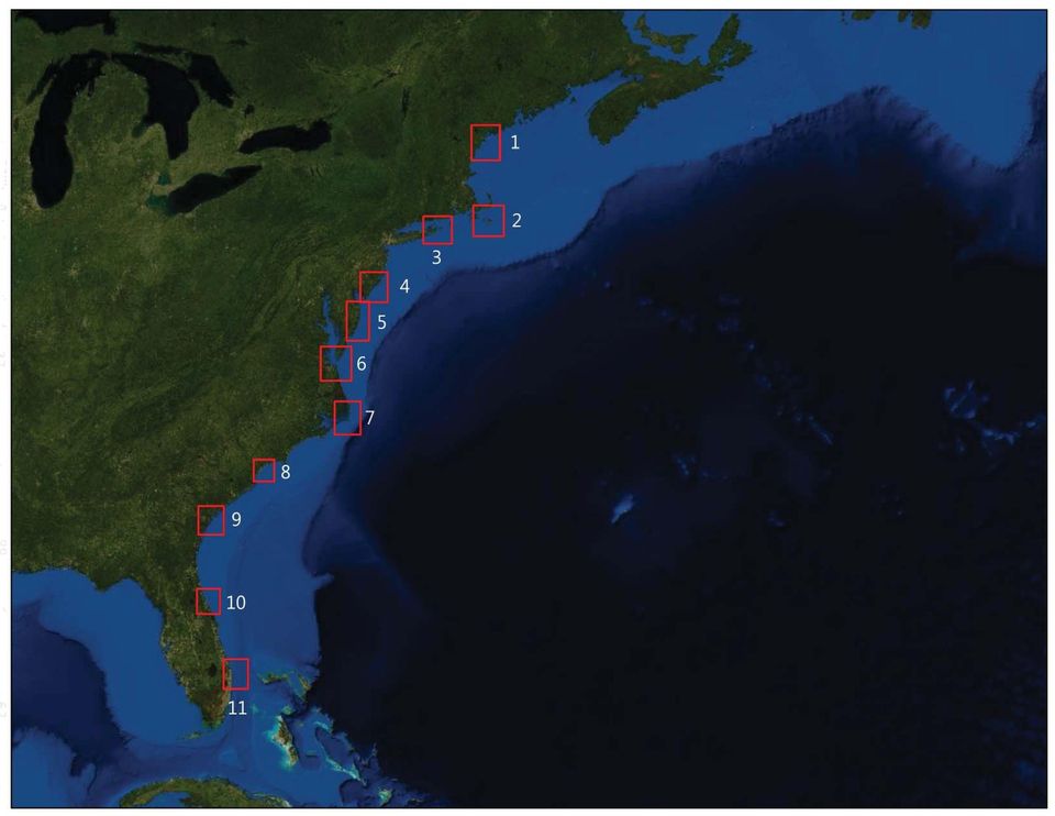
4 EAST COAST The Eastern Seaboard of the United States includes some of the largest metropolitan areas in the country, including Boston, New York City, Washington D.C., and Miami. Stretching from Maine to Florida, over one third of the country (more than 100 million people) live along the East Coast, fueling commerce, tourism, urban development, and transportation routes. The region is rich in history, natural beauty, and culture. Given the significant seasonal use of beaches and island vacation resorts along the coast, advanced planning for coastal inundation events and evacuations are essential for the safety of visitors and residents alike. Although the U.S. Atlantic coast has rarely been impacted by tsunamis, the communities and people who live on the Atlantic coast, especially near estuaries, inlets, and bays, are at risk for coastal storm events and inundation. Destructive hurricanes and nor easters frequently travel up the coast, fueled by currents in the Gulf Stream. These storms cause coastal flooding, coastal erosion, and highgust winds. Each year, hurricanes cause millions of dollars in damage and often, in some of the larger events, significant loss of life. Tsunamis are very rare and do not pose the same risk to the region. However, the 1929 Grand Banks earthquake and evidence of past submarine landslide events, remind us that the East Coast has experienced tsunamis in the past. NOAA s DEMs provide detailed, accurate depictions of U.S. coasts that are used by our State partners in the National Tsunami Hazard Mitigation Program. These DEMs and the underlying data can also support scientists, coastal managers, and policy makers in effectively managing marine ecosystems and coastal resources, coordinating planning and mitigation efforts, and better understanding the impacts of coastal hazards. The DEMs in this booklet provide a glimpse of the coastal relief for some of the cities along the U.S. East Coast. 1. Portland, ME 2. Nantucket, MA 3. Montauk, NY 4. Atlantic City, NJ 5. Ocean City, MD 6. Virginia Beach, VA 7. Cape Hatteras, NC 8. Myrtle Beach, SC 9. Savannah, GA 10. Daytona Beach, FL 11. Palm Beach, FL

5
6 DIGITAL ELEVATION MODEL Portland, Maine

7 NOAA Knows... PORTLAND, MAINE National Oceanic and Atmospheric Administration U.S. Department of Commerce 2011 Google Why Model Portland, Maine? Portland is the largest city in the state of Maine, with an estimated population of over 60,000 people. Portland is located on a Peninsula in Casco Bay, on the Gulf of Maine, about fifty miles north of the New Hampshire border. As Maine s primary shipping and manufacturing center, petroleum transportation accounts for much of the traffic through the port. In addition, the city produces paper, processed foods, leather, and machinery. Maine is famous for its rockbound coast buttressed by rugged, unchanging cliffs of stone. Rocky points in the area, such as the famous Portland Head cliffs, show little change after a hundred years of storms. Maine s bedrock is very strong and consolidated and resists erosion from waves and weather. Other parts of the Maine coast, however, have a soft coast of loose or unconsolidated materials that are subject to erosion. Although a slow, steady rise in sea-level is the underlying reason for modification of the coast, the more noticeable erosion occurs quickly during individual storms or landslide events. The Portland DEM serves as an important tool for community planners when preparing the community for coastal inundation and storm events. Who Provided the Data? - Office of Coast Survey (OSC) - Coastal Services Center (CSC) - National Geophysical Data Center (NGDC) - Joint Airborne Lidar Bathymetry Technical Center of Expertise (JALBTCX) - U.S. Geological Survey (USGS) - U.S. Army Corps of Engineers (USACE) - The University of New Hampshire (UNH) - Maine Office of Geographic and Environmental Information (MEGIS) dem.info@noaa.gov

8 DIGITAL ELEVATION MODEL Nantucket, Massachusetts

9 NOAA Knows... National Oceanic and Atmospheric Administration U.S. Department of Commerce NANTUCKET, MASSACHUSETTS 2011 Google Why Model Nantucket, Massachusetts? The Nantucket DEM covers the coastal region surrounding the town of Nantucket, Massachusetts on Nantucket Island. It spans Nantucket Sound from Martha s Vineyard on the west to Nantucket Island on the east, and north to Cape Cod and extends into the Atlantic Ocean. Nantucket s population more than quadruples in the summer season, as tourists and summer residents flock out to the island for its natural beauty, quaint New England feel, and beautiful beaches. The coastal morphology of the Cape Cod and Nantucket Sound region varies rapidly as alongshore currents move sediments near the coast. For example, in April 2007, a breach was opened along the southern shore of Katama Bay on Martha s Vineyard, dramatically altering current dynamics and sediment erosion, migration, and deposition in the area. In addition, strong hurricanes and Nor-easters can considerably alter the coastlines and breakwaters in the area posing risks for communities in close proximity to the shoreline. The Nantucket DEM is an important tool in helping community planners with hazard mitigation and damage prevention tactics during future coastal storm events. Who Provided the Data? - Office of Coast Survey (OSC) - Coastal Services Center (CSC) - National Geophysical Data Center (NGDC) - U.S. Geological Survey (USGS) - U.S. Army Corps of Engineers (USACE) - Massachusetts Office of Geographic and Environmental Information (MassGIS) dem.info@noaa.gov

10 DIGITAL ELEVATION MODEL Montauk, New York

11 NOAA Knows... National Oceanic and Atmospheric Administration MONTAUK, NEW YORK U.S. Department of Commerce 2011 Google Why Model Montauk, New York? Montauk is located on the South Shore of Long Island and has a population of more than 4,000 people. The town is located on the tip of South Fork peninsula and boasts the largest commercial and recreational fishing fleet in all of New York State. The saltwater fishing in Montauk is world renowned. The town s seaside position, 20 miles off of the Connecticut coast, has also made it useful for Army, Navy, Coast Guard, and Air Force facilities. Tourists visit Montauk to fish, surf, and experience the history but also to enjoy its natural beauty through the several state parks that exist in the area. While rarer than the famous Nor easters and hurricanes that cause flooding and coastal inundation, submarine landslides along the Atlantic continental slope have the potential for generating locally destructive tsunamis. The DEM of the area will help local planners prepare the community in the face of future storm events. Who Provided the Data? - NOAA s National Ocean Service (NOS) - Office of Coast Survey (OCS) - Coastal Services Center (CSC) - National Geophysical Data Center (NGDC) - U.S. Geological Survey (USGS) - U.S. Army Corps of Engineers (USACE) Photo Credit: dem.info@noaa.gov

12 DIGITAL ELEVATION MODEL Atlantic City, New Jersey

13 NOAA Knows... National Oceanic and Atmospheric Administration ATLANTIC CITY, NEW JERSEY U.S. Department of Commerce 2011 Google Why Model Atlantic City, New Jersey? Atlantic City is located along the southern New Jersey Atlantic seaboard, just north of the mouth of Delaware Bay. Many rural communities surround Delaware Bay, while rapidly growing suburban and developing urban populations are popping up in the region along the Atlantic coast. New Jersey s coastal economy is focused mostly on tourism, but also on commercial and recreational fishing. The nearby Outer Coastal Plain supports the economy by providing habitat to wildlife, migratory birds, and marine life. Barrier islands to the east protect the wetlands and white-sand beaches. Coastal processes such as wave action, along shore currents, and tidal cycles continually re-shape and modify the New Jersey coastline. The 1929 Grand Banks earthquake that generated a more than two foot tsunami in Atlantic City is the region s only confirmed tsunami. However, the densely populated New Jersey coast is at risk from many natural hazards: storm surge, erosion, and coastal flooding making DEM modeling an important tool for hazard managers and local planners. Who Provided the Data? - NOAA s National Ocean Service (NOS) - Office of Coast Survey (OCS) - Coastal Services Center (CSC) - National Geophysical Data Center (NGDC) - U.S. Geological Survey (USGS) - U.S. Army Corps of Engineers (USACE) - Joint Airborne LiDAR Bathymetry Technical Center of Expertise (JALBTCX) Photo Credit: dem.info@noaa.gov

14 DIGITAL ELEVATION MODEL Ocean City, Maryland

15 NOAA Knows... National Oceanic and Atmospheric Administration OCEAN CITY, MARYLAND U.S. Department of Commerce 2011 Google Why Model Ocean City, Maryland? The Ocean City DEM includes the dynamic barrier islands, Fenwick and Assateague, located off of the Delaware, Maryland and Virginia coasts. Ocean City, a popular vacation destination for many residents on the Eastern Seaboard, is easily accessible to more than 30 million people. Each year, approximately eight million people visit the area to enjoy the beach front and local activities. The two barrier islands are unstable environments with constant erosion, deposition, and migration of sediment from wave action. Along with general sediment transportation issues, rising sea level is a concern for coastal managers and property owners. To help stabilize the barrier islands, Ocean City uses beach nourishment and dune stabilization projects to protect their beaches and communities. In 1933, a hurricane opened up the current Ocean City Inlet, prompting the U.S. Army Corps of Engineers to build two stone jetties to stabilize the navigation channel. While far rarer than hurricanes, Ocean City did experience tsunami waves of over one foot from the 1929 Grand Banks earthquake. Tsunamis, along with greater risks from coastal hurricanes and the low elevations in the area, make the Ocean City DEM a useful tool for local planners, inundation modelers, and hazard managers. Who Provided the Data? - Office of Coast Survey (OCS) - Coastal Services Center (CSC) - National Geophysical Data Center (NGDC) - U.S. Geological Survey (USGS) - U.S. Army Corps of Engineers (USACE) dem.info@noaa.gov

16 DIGITAL ELEVATION MODEL Virginia Beach, Virginia

17 NOAA Knows... National Oceanic and Atmospheric Administration VIRGINIA BEACH, VIRGINIA U.S. Department of Commerce 2011 Google Why Model Virginia Beach, Virginia? Virginia Beach is a vacation resort city located on the Atlantic Ocean near the mouth of the Chesapeake Bay. It is the most heavily populated city in the commonwealth of Virginia, with close to 500,000 residents. The area boasts several state parks, historic sites, protected beach fronts, military bases, and universities. Along with its heavy commerce and agricultural industries, the city serves as a main transportation hub via its network of shipping and rail lines. The DEM of Virginia Beach also covers the coastal area surrounding the city, including Norfolk, Portsmouth, Chesapeake, Hampton, and Newport News all of these low-lying cities are prone to hurricane damage and inundation. Virginia Beach is located within the geologic region called the Atlantic Coastal Plain: a thick basement layer of igneous and metamorphic rock overlaid with a thick wedge of sediments that increases in thickness and dips towards the shoreline. The area has long shorelines, frequented ports, and heavily populated coastal communities. These factors make Virginia Beach a high risk area for inundation events. Elevation modeling in the area will help local managers and hazard planners mitigate future storms and hazards. Who Provided the Data? - NOAA s National Ocean Service (NOS) - Office of Coast Survey (OSC) - Coastal Services Center (CSC) - National Geophysical Data Center (NGDC) - U.S. Geological Survey (USGS) - U.S. Army Corps of Engineers (USACE) - National Geodetic Survey (NGS) - Coastal Survey Development Laboratory (CSDL) - Virginia Coast Reverse-Long Term Ecological Research (VCR/LTER) - University of Virginia (UVA) dem.info@noaa.gov

18 DIGITAL ELEVATION MODEL Cape Hatteras, North Carolina

19 NOAA Knows... National Oceanic and Atmospheric Administration U.S. Department of Commerce CAPE HATTERAS, NORTH CAROLINA 2011 Google Why Model Cape Hatteras, North Carolina? Cape Hatteras is located on Hatteras Island, a low-lying sandy barrier bar that is bordered by the Atlantic Ocean to the east and by Pamlico Sound to the west. Hatteras Island makes up a small piece of what is called the North Carolina Outer Banks, a series of islands along the eastern coast of North Carolina that form a quiet sound and protective barrier for the mainland. Beautiful beaches in the area make Cape Hatteras and the Outer Banks a popular tourist destination. The coastline on Hatteras Island is constantly changing due to two colliding currents, the Labrador and the Florida, that create turbulent waters, perilous seas, high shoals, and shallow sandbars. The Cape Hatteras National Seashore is a protected area that spans over 30,000 acres, and includes the Hatteras, Bodie, and Ocracoke Islands. In contrast to the remainder of the Outer Banks, it is one of the largest stretches of undeveloped seashore on the U.S. Atlantic coast. Overall, the area is an infamous target for northbound hurricanes, which have been known to devastate the area and the surrounding beach front. The DEM of Cape Hatteras is an important tool for local hazard mitigation and community planning, and will help professionals in understanding the risks associated with high storm events and coastal inundation. Who Provided the Data? - NOAA s National Ocean Service (NOS) - Office of Coast Survey (OCS) - National Geophysical Data Center (NGDC) - U.S. Army Corps of Engineers (USACE) - University of New Hampshire s Center for Coastal and Ocean Mapping/Joint Hydrographic Center (CCOM/JHC) - North Carolina Division of Emergency Management Floodplain Mapping Program (NCDEM-FPMP) dem.info@noaa.gov

20 DIGITAL ELEVATION MODEL Myrtle Beach, South Carolina

21 NOAA Knows... MYRTLE BEACH, SOUTH CAROLINA National Oceanic and Atmospheric Administration U.S. Department of Commerce 2011 Google Why Model Myrtle Beach, South Carolina? Myrtle Beach is located in the northeastern part of South Carolina, along a strip of resort towns known as the Grand Strand. The city is situated on a close-in island, between the Atlantic Intracoastal Waterway to the west and the Atlantic Ocean to the east. The city of Myrtle Beach is one of the fastest growing metropolitan areas in the United States, with a city population nearing 100,000 and a regional population over 350,000. Known for its wide sandy beaches and numerous golf courses, the Myrtle Beach area is one of the major coastal resorts and tourist destinations along the South Atlantic seaboard, attracting over 14 million visitors a year. Geographically, about half of the land area of South Carolina is part of the South Atlantic Coastal Plain, which is fringed by the Sea Islands and separated from the mainland by salt marshes, lagoons, and sounds. The area is extremely vulnerable to flooding and damages caused by fierce northbound hurricanes, which have been known to devastate the area and the surrounding beach front. The DEM of Myrtle Beach is an important tool for local hazard mitigation and community planners in understanding the risks associated with future high storm events and occurrences of coastal inundation. Who Provided the Data? - NOAA s National Ocean Service (NOS) - National Geophysical Data Center (NGDC) - U.S. Geological Survey (USGS) - U.S. Army Corps of Engineers (USACE) - Coastal Carolina University (CCU) - Coastal Science and Engineering, Inc. (CSE) - Horry Count County, South Carolina dem.info@noaa.gov
22 DIGITAL ELEVATION MODEL Savannah, Georgia
23 NOAA Knows... SAVANNAH, GEORGIA National Oceanic and Atmospheric Administration U.S. Department of Commerce 2011 Google Why Model Savannah, Georgia? Savannah is an important seaport, industrial center, historical player, and cultural hub in the southern United States. Savannah is located along the Atlantic coast of northern Georgia, and the DEM of Savannah provides coverage of the area surrounding the Savannah River including easternmost Georgia and the southern tip of South Carolina. The region is characterized by its barrier islands, tidal inlets, extensive sand shoals, and wide tidal marshlands. The barrier islands were formed by river deposition and by sea level fluctuation in the Pleistocene. River inlets in the area are characterized by sandy shoals formed as large sediment loads which pose as threats for traveling watercraft. Sediment deposition, alongshore currents, tidal cycles, and wave action modify the shoreline seasonally. Inland marshlands form a network of creeks, steams, and estuaries that are prone to seasonal and tidal flooding. The area is extremely vulnerable to flooding and damages caused by hurricanes and coastal storms. The DEM of Savannah is an important tool for local hazard mitigation and community planners in understanding the risks associated with future high storm events and coastal inundation. Who Provided the Data? - NOAA s National Ocean Service (NOS) - Office of Coast Survey (OCS) - National Geophysical Data Center (NGDC) - National Geodetic Survey (NGS) - U.S. Army Corps of Engineers (USACE) dem.info@noaa.gov
24 DIGITAL ELEVATION MODEL Daytona Beach, Florida
25 NOAA Knows... DAYTONA BEACH, FLORIDA National Oceanic and Atmospheric Administration U.S. Department of Commerce 2011 Google Why Model Daytona Beach, Florida? Daytona Beach, a popular vacation destination spot, is bordered to the north by Palm Coast, Flagler Beach, and Ormond Beach, and to the south by Daytona Beach Shores and New Smyrna Beach. The region includes a long, heavily populated sandbar that is largely isolated from mainland Florida by the Halifax River lagoon. The entrance to the lagoon, whose banks provide anchorage for numerous ships and sailing vessels, is through the mouth of Ponce de Leon Inlet. The Atlantic Intracoastal Waterway, which stretches from Miami to Maine and is maintained by the U.S. Army Corps of Engineers, passes through the Halifax River lagoon. The Atlantic shoreline near Daytona Beach is a dynamic system. Sand is constantly being moved by wind, waves, and tidal action. Shorelines, islands, spits, bars, and dunes change shape, migrate, shrink, grow, and even disappear as part of dynamic natural processes in the area. Coastal storms along fragile low lying communities such as Daytona Beach pose risks associated with floodwater inundation, and DEMs help to model risks and prevent damages in these communities. Who Provided the Data? - NOAA s National Ocean Service (NOS) - Office of Coast Survey (OCS) - Coastal Services Center (CSC) - National Geophysical Data Center (NGDC) - U.S. Army Corps of Engineers (USACE) - Florida Fish and Wildlife Research Institute (FWRI) - U.S. Geological Survey (USGS) dem.info@noaa.gov
26 DIGITAL ELEVATION MODEL Palm Beach, Florida
27 NOAA Knows... PALM BEACH, FLORIDA National Oceanic and Atmospheric Administration U.S. Department of Commerce 2011 Google Why Model Palm Beach, Florida? Palm Beach is an affluent coastal town made up of nearly 100,000 residents. Located between Jupiter and Lake Worth, it is a popular tourist location and is frequented in the winter months. The area is known for golfing, birding, boating, diving, and an array of other outdoor pastimes. Geographically, Palm Beach is the easternmost town in Florida and is located on a 16-mile long barrier island with white sand beaches that stretch into the Atlantic Ocean. Some of the strongest hurricanes in history, such as the San Felipe-Okeechobee Hurricane of 1928, have caused heavy casualties and extensive destruction to the area. Hurricanes are of major concern to current residents, especially since the low-lying area is extremely vulnerable to flooding. It is very important to assess how the community may be affected by a storm surge or tsunami wave. The DEM of Palm Beach is an important tool in understanding how these events may affect or alter possible impending flood waters. Who Provided the Data? - National Geophysical Data Center (NGDC) - NOAA s National Ocean Service (NOS) - Office of Coast Survey (OCS) - Coastal Services Center (CSC) - U.S. Army Corps of Engineers (USACE) - Japan s Ministry of Economy, Trade, and Industry (METI) - National Aeronautics and Space Administration (NASA) - South Florida Water Management District (SFWMD) - County of Palm Beach - Florida Department of Emergency Management (FDEM) dem.info@noaa.gov
28
29 This flipbook is part of a Regional DEM Series that is based on the work of a team of NOAA and CIRES scientists, led by Dr. Barry Eakins and Lisa Taylor. To learn more about coastal DEMs and DEM development in support of coastal management and research, visit
30 2011, NOAA NGDC Design and Layout: Siobhan Collins Photographs from NOAA Photo Library Editors and contributors: Barry Eakins, Lisa Taylor, Susan McLean, Loren Pahlke, Heather McCullough, Pamela Grothe, Christopher Amante, Elliot Lim, Kelly Carignan, Matthew Love, and Dorothy Friday
PACIFIC ISLANDS DIGITAL ELEVATION MODELS. Coastal Models Supporting our Nation s Needs through Science and Technology
 PACIFIC ISLANDS DIGITAL ELEVATION MODELS Coastal Models Supporting our Nation s Needs through Science and Technology All of the coastal digital elevation models (DEMs) in this presentation were created
Using LIDAR to monitor beach changes: Goochs Beach, Kennebunk, Maine
 Geologic Site of the Month February, 2010 Using LIDAR to monitor beach changes: Goochs Beach, Kennebunk, Maine 43 o 20 51.31 N, 70 o 28 54.18 W Text by Peter Slovinsky, Department of Agriculture, Conservation
WEST COAST DIGITAL ELEVATION MODELS. Coastal Models Supporting our Nation s Needs through Science and Technology
 WEST COAST DIGITAL ELEVATION MODELS Coastal Models Supporting our Nation s Needs through Science and Technology All of the coastal digital elevation models (DEMs) in this presentation were created by
AN INITIATIVE TO IMPROVE
 L OW E R C A R M E L R I V E R A N D L AG O O N F L O O D P L A I N R E S TO R AT I O N A N D E N H A N C E M E N T P R O J E C T AN INITIATIVE TO IMPROVE FLOOD PROTECTION RESTORE AND PROTECT RIPARIAN
Hurricanes and Storm Surge www.hcfcd.org/tropicalweather
 Hurricanes and Storm Surge www.hcfcd.org High-level winds fl ow outward Strong surface winds spiral inward EYE Calm, sometimes cloudfree, sinking air Air sinks in calm area at the storm s eye THUNDERSTORMS
Predicting Coastal Hazards: A Southern California Demonstration
 Predicting Coastal Hazards: A Southern California Demonstration Patrick Barnard United States Geological Survey Coastal and Marine Geology Team Santa Cruz, CA Southern California Multi-hazards Demonstration
Grants Announced June 16, 2014 from the Hurricane Sandy Coastal Resiliency Competitive Grant Program
 Connecticut Grants Announced June 16, 2014 from the Hurricane Sandy Coastal Resiliency Competitive Grant Program Enhancing Mill River's Flood Resiliency and Habitat Corridor Mill River Collaborative Grant
Storm Surge: A Rising Danger by Andrew M. Dzambo
 Storm Surge: A Rising Danger by Andrew M. Dzambo Citizens of the United States are migrating towards the nation s coasts; according to the U.S. Census Bureau, the U.S. coastal watershed county population
Most Vulnerable US Cities to Storm Surge Flooding. August 2015 2 COPLEY PLACE BOSTON, MA 02116 T: 617.423.2800 F: 617.423.2808
 Most Vulnerable US Cities to Storm Surge Flooding August 2015 2 COPLEY PLACE BOSTON, MA 02116 T: 617.423.2800 F: 617.423.2808 Introduction Hurricane Katrina was a stark reminder that strong winds are only
HAZUS 2014. 7 th Annual Conference
 HAZUS 2014 7 th Annual Conference HAZUS Comparison of Storm Surge Levels from Different Hurricanes to the Newest SLOSH Models for Berkeley, Charleston, & Dorchester Counties Along the SC Coastline. Charlie
What if Hurricane Sandy made landfall on the SC Coastline???
 What if Hurricane Sandy made landfall on the SC Coastline??? Charlie Kaufman Dorchester County Emergency Management Department Dr. Norm Levine College of Charleston: Lowcountry Hazards Center Background
Flood Risk Management
 Flood Risk Management Value of Flood Risk Management Every year floods sweep through communities across the United States taking lives, destroying property, shutting down businesses, harming the environment
Flood Risk Management
 Flood Risk Management Value of Flood Risk Management Value to Individuals and Communities Every year floods sweep through communities across the United States taking lives, destroying property, shutting
Coastal Erosion Hazard Monitoring on the South Shore of Long Island, New York Joseph J. Tanski 1 and Barry Pendergrass 2
 Abstract Coastal Erosion Hazard Monitoring on the South Shore of Long Island, New York Joseph J. Tanski 1 and Barry Pendergrass 2 The Atlantic Coast of New York Erosion Monitoring Program (ACNYMP), initiated
The Crystal Coast: A Unique Geological Phenomenon. Kate Jablonski. Quantitative Studies in Rocks and Minerals. Steve Teeter and Sandie Brundin
 The Crystal Coast 1 The Crystal Coast: A Unique Geological Phenomenon Kate Jablonski Quantitative Studies in Rocks and Minerals Steve Teeter and Sandie Brundin Thursday, July 15, 2010 The Crystal Coast
30 DAY PUBLIC NOTICE MAINTENANCE DREDGING OF THE FEDERAL NAVIGATION PROJECT IN COHASSET HARBOR COHASSET AND SCITUATE, MASSACHUSETTS
 .-ro:'j - I US Army Corps of Engineers r& New England District 696 Virginia Road Concord, MA 01742-2751 Public Notice In Reply Refer to: Mr. Craig Martin nae-pn-nav@usace.army.mil Programs/Project Management
Figure 1. USGS Coastal Change Hazards home page (http://marine.usgs.gov/kb/ views/cch/). This topical node of the USGS Coastal and Marine Knowledge
. This topical node of the USGS Coastal and Marine Knowledge") THE COASTAL CHANGE HAZARDS NODE OF THE U.S. GEOLOGICAL SURVEY (USGS) COASTAL AND MARINE KNOWLEDGE BANK: ONLINE SCIENTIFIC RESOURCES FOR COASTAL ZONE MANAGEMENT AND DISASTER PREPAREDNESS M. Dennis Krohn,
THE COASTAL CHANGE HAZARDS NODE OF THE U.S. GEOLOGICAL SURVEY (USGS) COASTAL AND MARINE KNOWLEDGE BANK: ONLINE SCIENTIFIC RESOURCES FOR COASTAL ZONE MANAGEMENT AND DISASTER PREPAREDNESS M. Dennis Krohn,
Future of our coasts: Potential for natural and hybrid infrastructure to enhance ecosystem and community resilience Ariana Sutton-Grier
 Future of our coasts: Potential for natural and hybrid infrastructure to enhance ecosystem and community resilience Ariana Sutton-Grier University of Maryland & National Oceanic and Atmospheric Administration
Inlets Online: A Tutorial for Evaluating Inlet/Beach Processes Using Aerial Photography
 Inlets Online: A Tutorial for Evaluating Inlet/Beach Processes Using Aerial Photography by Mark R. Byrnes, Feng Li, and Julie D. Rosati PURPOSE: This Coastal and Hydraulics Engineering Technical Note (CHETN)
Storm tide is the water level rise during a storm due to the combination of storm surge and the astronomical tide.
 INTRODUCTION TO STORM SURGE Introduction to Storm Surge BOLIVAR PENINSULA IN TEXAS AFTER HURRICANE IKE (2008) What is Storm Surge? Inland Extent Storm surge can penetrate well inland from the coastline.
Goal 1 To protect the public health, safety and property from the harmful effects of natural disasters.
 Plan Framework for Coastal Management The purpose of this element is to provide for the protection of residents and property in within the coastal area of the host community, and to limit expenditures,
Ecosystem Services in the Greater Houston Region. A case study analysis and recommendations for policy initiatives
 Ecosystem Services in the Greater Houston Region A case study analysis and recommendations for policy initiatives Ecosystem Services Ecosystems provide services through their natural processes that we
Storm tide is the water level rise during a storm due to the combination of storm surge and the astronomical tide.
 INTRODUCTION TO STORM SURGE Introduction to Storm Surge National Hurricane Center Storm Surge Unit BOLIVAR PENINSULA IN TEXAS AFTER HURRICANE IKE (2008) What is Storm Surge? Inland Extent Storm surge can
Martin County Coastal GIS Program St Lucie Inlet Planning Tool
 Martin County Coastal GIS Program St Lucie Inlet Planning Tool Alexandra Carvalho, Ph.D., GISP Kathy Fitzpatrick, P.E. Jessica Garland Martin County, Florida Presentation Overview County Coastal Programs
ECONOMIC ANALYSIS FLOOD DAMAGE REDUCTION. Lower Carmel River Floodplain Restoration and Enhancement Project
 ECONOMIC ANALYSIS FLOOD DAMAGE REDUCTION Lower Carmel River Floodplain Restoration and Enhancement Project I. Description of the Project and its Relationship to Other Projects in the Proposal The Lower
4.2 Buena Vista Creek Watershed
 Buena Vista Creek Watershed 4.2 Buena Vista Creek Watershed Watershed Overview The Buena Vista Creek Watershed is the fourth-largest system within the Carlsbad Hydrologic Unit. The watershed extends approximately
Real-time Ocean Forecasting Needs at NCEP National Weather Service
 Real-time Ocean Forecasting Needs at NCEP National Weather Service D.B. Rao NCEP Environmental Modeling Center December, 2005 HYCOM Annual Meeting, Miami, FL COMMERCE ENVIRONMENT STATE/LOCAL PLANNING HEALTH
Connecting Science and Management for Virginia s Tidal Wetlands. In this issue...
 In this issue... We review the relationship between science and the management of tidal wetlands in Virginia. The program has evolved over the past four decades to address: E the public benefits provided
Communicating the Flood Risk
 Communicating the Flood Risk National Hurricane Conference Orlando, Florida April 17, 2014 Jeanne M. Salvatore, Senior Vice President, Public Affairs and Chief Communications Officer @JeanneSalvatore Insurance
Impacts of Sea-Level Rise on National Wildlife Refuges
 Impacts of Sea-Level Rise on National Wildlife Refuges Considerations for Land Protection Priorities Photo: National Oceanic and Atmospheric Administration O ne of the well-documented impacts of climate
asbpa Preserving our coastal economy and ecology since 1926
 Preserving our coastal economy asbpa and ecology since 1926 HEALTHY BEACHES ARE VITAL TO OUR WAY OF LIFE People in the United States highly prize the thousands of miles of sandy beaches along our nation
Risk Analysis, GIS and Arc Schematics: California Delta Levees
 Page 1 of 7 Author: David T. Hansen Risk Analysis, GIS and Arc Schematics: California Delta Levees Presented by David T. Hansen at the ESRI User Conference, 2008, San Diego California, August 6, 2008 Abstract
RESTORATION AND ENHANCEMENT OF SOUTHERN CALIFORNIA LAGOONS
 RESTORATION AND ENHANCEMENT OF SOUTHERN CALIFORNIA LAGOONS by Hany Elwany, Ph.D. Scripps Institution of Oceanography Headwaters to Oceans Conference 25 October 2003 CE Ref #03-22 San Diego County Lagoons
http://www.nj.gov/dep/shoreprotection/storm.htmhris TUCKER
 COASTAL STORM SURVEY NEW JERSEY DEPARTMENT OF ENVIRONMENTAL PROTECTION BUREAU OF COASTAL ENGINEERING - TOMS RIVER NJ 12:00 P.M. TUESDAY, MARCH 1, 2005 NEW JERSEY COASTLINE INCLUDING RARITAN AND DELAWARE
Lower Raritan Watershed Management Area Stormwater & Flooding Subcommittee Strategy Worksheet LRSW-S3C1
 Strategy Name: Reduce Existing Potential for Flood Damages LRSW-S3C1. Develop and implement a program to: Minimize flood damages through the use of structural measures. Minimize flood damages through the
Eastern Connecticut Risk & Vulnerability Assessment Workshop
 Coastal Resilience New York and Connecticut A Tool for Coastal Planning in a Changing World Eastern Connecticut Risk & Vulnerability Assessment Workshop January 11, 2012 Waterford Town Hall - Auditorium
30-DAY PUBLIC NOTICE CHELSEA RIVER, EAST BOSTON MASSACHUSETTS EMERGENCY STREAMBANK PROTECTION PROJECT
 PUBLIC NOTICE Engineering/Planning 696 Virginia Road Concord, MA 01742 Date: 10 November, 2015 Comment Period Ends: 10 December, 2015 In Reply, Refer To: Robert Russo Or by e-mail: Robert.S.Russo@usace.army.mil
RESUME for Christopher G. Creed, P.E.
 Page One of Five Current Position Senior Engineer / Vice-President for Olsen Associates, Inc. a coastal engineering consulting firm in Jacksonville, Florida. Education Master of Civil Engineering, 1992.
An Initial Assessment of the Impacts of Sea Level Rise to the California Coast
 An Initial Assessment of the Impacts of Sea Level Rise to the California Coast Photo by D. Revell 2/23/08 California Coastal Records Project Dr. David Revell and Matt Heberger, P.E. Dr. Peter Gleick, Bob
Impacts of Global Warming on North Carolina s Coastal Economy
 Impacts of Global Warming on North Carolina s Coastal Economy IMPACTS OF GLOBAL WARMING ON NORTH CAROLINA S COASTAL ECONOMY Key Findings Global warming is projected to have significant impacts on North
Briefing Paper on Lower Galveston Bay and Bayou Watersheds Lower Bay I: Armand Bayou to Moses Lake and Adjacent Bay Waters
 Briefing Paper on Lower Galveston Bay and Bayou Watersheds Lower Bay I: Armand Bayou to Moses Lake and Adjacent Bay Waters Jim Lester, PhD. and Lisa Gonzalez Houston Advanced Research Center Galveston
Mouth of the Columbia River Jetties Major Rehabilitation Study
 Mouth of the Columbia River Jetties Major Rehabilitation Study PNWA Port of Vancouver January 29, 2010 US Army Corps of Engineers Project Overview Background Corps Guidance for Major Rehab Project Alternatives
Climate Change in Coastal Florida: Economic Impacts of Sea Level Rise
 Climate Change in Coastal Florida: Economic Impacts of Sea Level Rise CLIMTE CHNGE IN COSTL FLORID: ECONOMIC IMPCTS OF SE LEVEL RISE Context Global warming is expected to cause: Sea level rise Increased
RESEARCH. 2010 Massachusetts Recreational Boater Survey. Project Summary
 Coastal and Marine Spatial Planning RESEARCH Project Summary 2010 Massachusetts Recreational Boater Survey The 2010 Massachusetts Recreational Boater Survey gathered spatial and economic data relating
Pay Later: The Cost of Inaction. Climate change will have a negative impact on many of the industries that 3500 3000 2500 2000 1500 1000 500 5.
 FACTS CONNECTICUT A M E R I C A N S E C U R I T Y P R O J E C T Pay Now, Pay Later: Connecticut The Environmental Protection Agency estimates that the cost of protecting Connecticut s coast from the potential
7) Coastal Storms: Multi-Hazard Analysis for New York City
 Coastal Storms: Multi-Hazard Analysis for New York City") 7) Coastal Storms: Multi-Hazard Analysis for New York City a) Hazard Profile i) Hazard Description Coastal storms, including nor'easters, tropical storms, and hurricanes, can and do affect New York City.
7) Coastal Storms: Multi-Hazard Analysis for New York City a) Hazard Profile i) Hazard Description Coastal storms, including nor'easters, tropical storms, and hurricanes, can and do affect New York City.
Existing Land Use Map
 ilsonmiller, nc. does not warrant data provided by other sources for accuracy or property appraisal, survey, or for zoning verification. ilsonmiller, nc. has not verified this data for accuracy nor has
Appendix J Online Questionnaire
 Appendix J Online Questionnaire In accordance with the Paperwork Reduction Act, this questionnaire was approved by the Office of Management and Budget (OMB). The OMB control number and expiration date
New Orleans Hurricane Storm Damage Risk Reduction System Tour March 23 24, 2012
 New Orleans Hurricane Storm Damage Risk Reduction System Tour March 23 24, 2012 Host: Falcolm E. Hull, Vice President/Technical Expert, ARCADIS, U.S. Inc. Attending: Cherie Coffman, Coastal Projection
noaa NOAA Technical Memorandum NESDIS NGDC-30 DIGITAL ELEVATION MODEL OF PORTLAND, MAINE: PROCEDURES, DATA SOURCES AND ANALYSIS
 NOAA Technical Memorandum NESDIS NGDC-30 DIGITAL ELEVATION MODEL OF PORTLAND, MAINE: PROCEDURES, DATA SOURCES AND ANALYSIS E. Lim L.A. Taylor B.W. Eakins K.S. Carignan R.R. Warnken P.R. Medley National
Hurricane Sandy. Management s Discussion And Analysis Hurricane Sandy
 64.6 affordable rental units were available per 100 very low income renters in 2011. The shortage of affordable housing and prevalence of severe rent burdens increased rapidly during 2009 to 2011, building
NOAA COASTAL SERVICES CENTER Strategic Plan: 2010 to 2015
 NOAA COASTAL SERVICES CENTER Strategic Plan: 2010 to 2015 N a t i o n a l O c e a n i c a n d A t m o s p h e r i c A d m i n i s t r a t i o n ( N O A A ) C o a s t a l S e r v i c e s C e n t e r March
Bob Ivarson, PE, D.WRE. Sustainable Water Technologies Business Conference. June 17, 2014
 Bob Ivarson, PE, D.WRE Sustainable Water Technologies Business Conference June 17, 2014 In the old days we use to talk about conservation. Unsustainability, often is the collision of good intentions with
Flooding in San Francisco Bay: Risks and Opportunities
 Flooding in San Francisco Bay: Risks and Opportunities Photo Judy Irving Pelican Media Authors Jeffrey Mount, Saracino & Mount LLC Jeremy Lowe, ESA PWA Flooding in San Francisco Bay: Risks and Opportunities
Fifth European Intensive Course on Applied Geomorphology
 Fifth European Intensive Course on Applied Geomorphology Mediterranean and Urban Areas Lisbon Algarve, 17-24 June 1996 228 229 VULNERABILITY OF THE BEACH-CLIFF SYSTEM OF PRAIA DA ROCHA ANA RAMOS PEREIRA
United States Army Corps of Engineers, Civil Works
 United States Army Corps of Engineers, Civil Works Fiscal Year 2013 Federal Program Inventory May 2013 Table of Contents Introduction... 2 Program Inventory... 3 1. Navigation... 3 2. Flood Risk Management...
Pete Slovinsky, Coastal Geologist, Maine Dept. of Agriculture, Conservation and Forestry
 MEGUG WINTER MEETING AGENDA FEB 2 ND, USM WISHCAMPER CENTER PORTLAND, ME 8:30 9:30am Registration and Poster Setup. Coffee, Tea, and Pastry served. 9:30 10am Opening Remarks, Announcements, and Updates
CHAPTER 7. EMERGENCY SERVICES
 CHAPTER 7. EMERGENCY SERVICES Although better forecasts and warning processes have helped save lives by providing more lead time to evacuate, the tremendous growth of development and human population in
Facing an Uncertain Future: Increasing Resilience at Marinas and Harbors. Recreational Boating Educational Conference December 11, 2014
 Facing an Uncertain Future: Increasing Resilience at Marinas and Harbors Recreational Boating Educational Conference December 11, 2014 Operators Face Change and Challenges Environmental Conditions Fluctuating
K-12 Environmental Education Market Analysis for the Hampton Roads Region
 K-12 Environmental Education Market Analysis for the Hampton Roads Region Final Report Submitted to the Estuarine Reserves Division of the National Oceanic and Atmospheric Administration. Submitted By:
A New Coastal Engineering Graduate Program
 Paper ID #12157 A New Coastal Engineering Graduate Program Dr. Robert W. Whalin, Jackson State University Dr. Robert W. Whalin, Professor of Civil and Environmental Engineering, and Director, Coastal Hazards
Freeboard Incentives work for residents, town officials in Hull, MA
 Freeboard Incentives work for residents, town officials in Hull, MA The Town of Hull, Massachusetts, is situated on a peninsula in the southernmost part of Massachusetts Bay. It is densely developed, and
Restoring Ecosystems. Ecosystem Restoration Services
 Restoring Ecosystems Ecosystem Restoration Services 2 Ecosystem Restoration Services AECOM s integrated approach sciencebased planning, with innovative design and execution delivers sustainable and cost-effective
Regulating Offshore Renewable Energy Leasing and Development
 Regulating Offshore Renewable Energy Leasing and Development Robert P. LaBelle Acting Associate Director Offshore Energy and Minerals Management Bureau of Ocean Energy Management, Regulation and Enforcement
APPENDIX K COASTAL RESOURCES
 APPENDIX K COASTAL RESOURCES Delaware Consistency Determination Statement of Consistency The Federal Aviation Administration (FAA) has determined that the proposed New York/New Jersey Philadelphia Metropolitan
Malcolm L. Spaulding Professor Emeritus, Ocean Engineering University of Rhode Island Narragansett, RI 02881
 Malcolm L. Spaulding Professor Emeritus, Ocean Engineering University of Rhode Island Narragansett, RI 02881 USACE Coastal and Hydraulics Laboratory(CHL) Data Infrastructure Workshop January 23, 2014 Overview
COASTAL DAMAGE INSPECTION SOUTHWEST VITI LEVU, FIJI AFTER CYCLONE SINA
 COASTAL DAMAGE INSPECTION SOUTHWEST VITI LEVU, FIJI AFTER CYCLONE SINA Brendan J. Holden SOPAC Technical Secretariat July 1992 SOPAC Technical Report 148 Prepared for: South Pacific Applied Geoscience
The Everglades & Northern Estuaries; St. Lucie River Estuary, Indian River Lagoon & Caloosahatchee Estuary. Water Flows & Current Issues
 The Everglades & Northern Estuaries; St. Lucie River Estuary, Indian River Lagoon & Caloosahatchee Estuary Water Flows & Current Issues Florida Governor Rick Scott August 20, 2013 Upper Chain of Lakes
Terms of Reference For First Joint Mission for the Pilot Programme on Climate Resilience (PPCR) In St. Vincent and the Grenadines
 In St. Vincent and the Grenadines") Terms of Reference For First Joint Mission for the Pilot Programme on Climate Resilience (PPCR) In St. Vincent and the Grenadines 1 Glossary of Terms and Abbreviations CIF IDB MTESP NEMO NESDC NESDP NGO
Terms of Reference For First Joint Mission for the Pilot Programme on Climate Resilience (PPCR) In St. Vincent and the Grenadines 1 Glossary of Terms and Abbreviations CIF IDB MTESP NEMO NESDC NESDP NGO
Presented by: Michael DePue, PE, CFM Annual Georgia Association of Floodplain Management Conference Lake Lanier Islands, Georgia March 23, 2010
 Flood Types and Characteristics Presented by: Michael DePue, PE, CFM Annual Georgia Association of Floodplain Management Conference Lake Lanier Islands, Georgia March 23, 2010 Agenda Why study flood types?
Photo by Jeff Thibodeau, Helios Land Design
 SECTION 11 REFERENCES Photo by Jeff Thibodeau, Helios Land Design PUBLIC REVIEW DRAFT Cape Cod Commission, Affordable Housing Funds, Memo from Paul Ruchinskas to County Commissioners, January 4, 2006.
Coastal Erosion Risk Mitigation Strategies applied in a Small Island Developing State: The Barbados Model
 Coastal Erosion Risk Mitigation Strategies applied in a Small Island Developing State: The Barbados Model BY Dr. Leo Brewster, Director Coastal Zone Management Unit, Barbados Presented At UNFCCC Expert
The St. Lucie River is 35 miles long and has two major forks, the North Fork and the South Fork. In the 1880s, the system was basically a freshwater
 The St. Lucie River is 35 miles long and has two major forks, the North Fork and the South Fork. In the 1880s, the system was basically a freshwater stream flowing into the Indian River Lagoon. An inlet
1. Executive Summary
 1. Executive Summary 1.1. The character of the coast of Wales is defined by continuous change, erosion and accretion, a dynamism that will increase in the future with climate change driven sea level rise
In the Caribbean, August and September are peak months during the hurricane season that lasts from June 1 through November 30.
 Hurricane Fact sheet What is a hurricane? A hurricane is a tropical storm with winds that have reached a constant speed of 74 miles per hour more. Hurricane winds blow in a large spiral around a relative
SENATE RESOLUTION No. 78 STATE OF NEW JERSEY. 214th LEGISLATURE INTRODUCED JULY 1, 2010
 SENATE RESOLUTION No. STATE OF NEW JERSEY th LEGISLATURE INTRODUCED JULY, 00 Sponsored by: Senator SEAN T. KEAN District (Monmouth) Senator ANDREW R. CIESLA District 0 (Monmouth and Ocean) Co-Sponsored
AP ENVIRONMENTAL SCIENCE 2010 SCORING GUIDELINES
 AP ENVIRONMENTAL SCIENCE 2010 SCORING GUIDELINES Question 4 (a) Based on the rate cited above, calculate the expected increase in sea level, in meters, during the next 50 years. One point can be earned
U.S. Fish and Wildlife Service will invest $15 million for post-sandy cleanup and marsh restoration on Long Island
 For Immediate Release: Wednesday, November 6, 2013 For further information: Michelle Potter, refuge manager, 631/286-0485 ext. 2112, Michelle_Potter@fws.gov Tom Sturm, public affairs specialist, 413/253-8339,
Hurricane Sandy Rebuilding Task Force
 Hurricane Sandy Rebuilding Task Force FACT SHEET: Progress to Date Cutting red tape to help get families back in their homes, get small businesses back on their feet and help communities rebuild their
2012 Project Summary NORTHEAST RECREATIONAL BOATER SURVEY
 2012 Project Summary NORTHEAST RECREATIONAL BOATER SURVEY image courtesy of Urban Harbors Institute of UMass Boston A partnership among industry, government, and nongovernmental organizations conducted
Norfolk Flooding Strategy Update. Presentation to Norfolk City Council March 27, 2012
 Norfolk Flooding Strategy Update Presentation to Norfolk City Council March 27, 2012 Presentation Overview The purpose of this presentation is to provide City Council an update on activities carried out
Jacksonville Port Authority: Fire and Rescue Marine Fire Station #40, Jacksonville, Florida
 Draft Tiered Site-Specific Environmental Assessment Jacksonville Port Authority: Fire and Rescue Marine Fire Station #40, Jacksonville, Florida Port Security Grant Program Project # 2008-GB-T8-K019 November
Guideline: A risk assessment approach to development assessment in coastal hazard areas
 Guideline: A risk assessment approach to development assessment in coastal hazard areas Prepared by: Environment Planning, Department of Environment and Heritage Protection State of Queensland, 2013. The
Shoreline Master Programs Handbook Chapter 15, Shoreline Stabilization
 Shoreline Master Programs Handbook Chapter 15, Shoreline Stabilization Publication Number: 11-06-010 7/15 Contents Introduction... 1 Chapter overview... 2 Description of shoreline stabilization... 2 Design
Long Island s Dynamic South Shore
 Long Island s Dynamic South Shore A Primer on the Forces and Trends Shaping Our Coast Jay Tanski Long Island s Dynamic South Shore A Primer on the Forces and Trends Shaping Our Coast Introduction Long
South Florida Sea Level Rise Projections and Flood Risk Concerns
 South Florida Sea Level Rise Projections and Flood Risk Concerns MIAMI MIAMI Biscayne Bay Glenn B. Landers, P.E. Planning and Policy Division Jacksonville District EVERGLADES NATIONAL PARK USACE Flood
Offshore Renewable Energy in Virginia
 Offshore Renewable Energy in Virginia Presented to the Renewable Natural Resources Foundation December, 8 2009 Neil Rondorf Vice President, Maritime Operations Science Applications International Corporation
Natural Disasters & Assessing Hazards and Risk. Natural Hazards and Natural Disasters
 Page 1 of 9 EENS 3050 Tulane University Natural Disasters Prof. Stephen A. Nelson Natural Disasters & Assessing Hazards and Risk This page last updated on 19-Aug-2014 Natural Hazards and Natural Disasters
2013 Annual Climate Summary for the Southeast United States
 Months of heavy rain forced the U.S. Army Corp of Engineers to open the spillways at Lake Hartwell, located at the headwaters of the Savannah River along the South Carolina-Georgia border, on July 9,.
Project Report. A Fiscal Impact Analysis of the Saco River & Camp Ellis Beach Shore Damage Mitigation Project
 Project Report A Fiscal Impact Analysis of the Saco River & Camp Ellis Beach Shore Damage Mitigation Project Presented To: Richard Michaud, City Administrator City of Saco 300 Main Street Saco, Maine 04072
4-H Marine Biology and Oceanography Proficiency Program A Member s Guide
 4-H Marine Biology and Oceanography Proficiency Program A Member s Guide OVERVIEW The 4 H Marine Biology and Oceanography Proficiency program helps you learn what you need to know about your 4 H project.
It s hard to avoid the word green these days.
 Going green : Environmental jobs for scientists and engineers Alice Ramey Alice Ramey is an economist in the Office of Occupational Statistics and Employment Projections, BLS. She is available at (202)
Most informed people realize that cumulative impacts have had
 Welcome to the First Issue of Rivers & Coast! The goal of the new Rivers & Coast newsletter is to keep readers well informed of current scientific understanding behind key environmental issues related
Fact Sheet RITA. Atlantic Coast U.S. Seaports. By Matthew Chambers. Select Atlantic Coast U.S. Seaports. Figure 1: Atlantic Coast U.S.
 FS-00 RIA Bureau of ransportation Statistics Fact Sheet Atlantic Coast U.S. Seaports October 00 By Matthew Chambers Atlantic coast U.S. seaports from Eastport, M(, through Key West, FL, are preparing for
STATUS REPORT FOR THE SUBMERGED REEF BALL TM ARTIFICIAL REEF SUBMERGED BREAKWATER BEACH STABILIZATION PROJECT FOR THE GRAND CAYMAN MARRIOTT HOTEL
 STATUS REPORT FOR THE SUBMERGED REEF BALL TM ARTIFICIAL REEF SUBMERGED BREAKWATER BEACH STABILIZATION PROJECT FOR THE GRAND CAYMAN MARRIOTT HOTEL performed by Lee E. Harris, Ph.D., P.E. Consulting Coastal
Remote sensing for the MTS
 Remote sensing for the MTS Jennifer M. Wozencraft Director, Program Manager, USACE National Coastal Mapping Program 24 June 2014, Innovative Technologies for a Resilient MTS Outline Background JALBTCX
Climate change impacts on city of Gdansk and its vicinity (Vistula Delta, Poland)
") Final International ASTRA Conference Espoo, 10-11 December, 2007 Climate change impacts on city of Gdansk and its vicinity (Vistula Delta, Poland) Dorota Kaulbarsz, Zbigniew Kordalski, Wojciech Jeglinski
Final International ASTRA Conference Espoo, 10-11 December, 2007 Climate change impacts on city of Gdansk and its vicinity (Vistula Delta, Poland) Dorota Kaulbarsz, Zbigniew Kordalski, Wojciech Jeglinski
POINTS TO CONSIDER WHEN BUYING SHORELINE PROPERTY
 POINTS TO CONSIDER WHEN BUYING SHORELINE PROPERTY You re considering buying a piece of property. You ve found two properties which meet your needs and interest you. Both properties are about two acres
Coastal Risk Management Guide. Incorporating sea level rise benchmarks in coastal risk assessments
 Coastal Risk Management Guide Incorporating sea level rise benchmarks in coastal risk assessments Published by: Department of Environment, Climate Change and Water NSW 59 61 Goulburn Street PO Box A290
Coastal Engineering Indices to Inform Regional Management
 Coastal Engineering Indices to Inform Regional Management Lauren Dunkin FSBPA 14 February 2013 Outline Program overview Standard products Coastal Engineering Index Conclusion and future work US Army Corps