Enschede The Netherlands
|
|
|
- Bryce Black
- 8 years ago
- Views:
Transcription
1 Photo: Gerard Kuster Enschede The Netherlands INTERNATIONAL INSTITUTE FOR GEO-INFORMATION SCIENCE AND EARTH OBSERVATION

2 Presentation content What s ITC all about Knowledge field: Geo-information Science and earth observation ITC s core activities Education Research Project services Partnerships Photo: Gerard Kuster Alumni

3 What s ITC all about? Established in 1950 Largest international institute for higher education in the Netherlands Autonomous organisation Under the aegis of the Minister for Development Cooperation and the Ministry of Education, Culture and Science of the Netherlands

4 Mission Provide international education through knowledge exchange Capacity building Institutional development For and in economically and technologically less developed countries

5 Key figures Staff staff core activities: 143 fte support staff core activities: 50 fte general support staff: 64 fte 26 nationalities Students 600 p/year PhD researchers 50 Alumni 17,883 mid-career professionals 169 countries

6 Natural Resources Department (NRS)

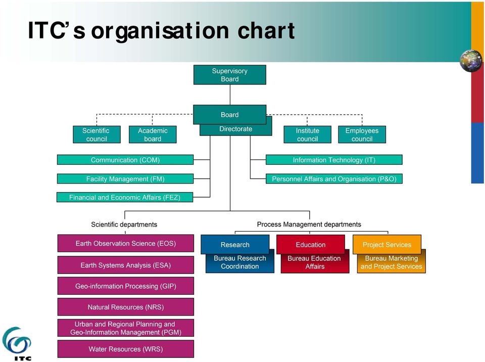
7 ITC s organisation chart
8 Facilities Well equipped building Lecture rooms MSc rooms Auditorium State-of-the-art computer facilities Laboratory facilities Restaurant Library Photo: Gerard Kuster Photo: Gerard Kuster Photo: Gerard Kuster Photo: Gerard Kuster

9 Lodging accommodation Well furnished rooms or apartments Student support Student affairs office Medical facilities Sports and social activities Long-life accounts Photo: Gerard Kuster Photo: Gerard Kuster

10 Knowledge field: Geo-information science and earth observation Apr May Jun Jul Aug Sep Oct Nov Dec Jan Feb Mar rice rice (soy-)beans maize groudnuts sugarcane Digital maps Planting Growing Period Harvesting Tabular data Satellite data Aerial data Field measurements Modelling Internet GIS Processing Synthesis Internet GIS INTERNATIONAL INSTITUTE FOR GEO-INFORMATION SCIENCE AND EARTH OBSERVATION

11 Geo-information science and earth observation Combination of tools and methods for the collection storage and processing of geo-spatial data and for the dissemination and use of these data and of services based on these data

12 Focus on tools and methods and on application of these in: urban planning land administration disaster management strengthening civil society water management earth sciences environmental management and biodiversity food security

13 Earth observation Collect data about the earth s surface and subsurface Based on aerospace survey techniques Remote sensing, Aerial photography, Radar, Airborne electronic-scanning devices, Satellites

14 Geographical Information Systems Database used to Store Manipulate Access Transform Study trend patterns Examine environmental issues Simulate outcome of project proposal or planning procedures Data collected through earth observation

15 Geo-information science and earth observation Apr May Jun Jul Aug Sep Oct Nov Dec Jan Feb Mar rice DATA COLLECTION Satellite data rice (soy-)beans maize groudnuts sugarcane Planting Growing Period Harvesting DATA COLLECTION Tabular data Digital maps Aerial data Field measurements G I S Modelling G I S ANALYSIS Processing Synthesis Internet GIS DISSEMINATION DATA Web portals & INFORMATION DISSEMINATION Internet GIS

16 ITC s core activities Education / training 50% Degree programme Diploma programme Certificate programme Research and Development 25% Research projects PhD studies Visiting Scientists Photo: Gerard Kuster

17 Project services 25% Institutional development Contract training Contract research and development Advisory services

18 Education at ITC A multicultural environment Photo: Gerard Kuster Photo: Gerard Kuster INTERNATIONAL INSTITUTE FOR GEO-INFORMATION SCIENCE AND EARTH OBSERVATION

19 Target group Primarily mid-career professionals and scientists from developing countries Increasingly professionals from industrialised countries

20 ITC s programmes and duration Degree programme: Master Master of Science Diploma programme: Postgraduate diploma Diploma 12 months 18 months 9 months 9 months Language of instruction is English

21 Certificate programme: - Short courses -Modules - Refresher courses (on site) -Tailor-made courses - Distance courses 3, 6, 9 and 12 weeks 3 weeks 1-2 weeks 1 week 8 months 6 weeks Language of instruction is English
22 Entry levels Programme Entry level: MSc degree BSc Master degree BSc Postgraduate diploma BSc Diploma Sec. school Certificate courses Sec. school
23 Overview of MSc, Master and PGD programmes Blocks and modules MSc: 18 months, 4 blocks Core modules Specialization modules Research profile modules MSc thesis Master: 12 months, 3 blocks Core modules Application/specialization modules Group and individual final assignments PGD: 9 months, first two blocks of MSc programme
24 Courses in the degree and diploma programmes: Geo-information Science and Earth observation for: Applied Earth Sciences Geoinformatics Geo-information Management Land Administration Natural Resources Management Urban Planning and Management Water Resources and Environmental Management
25 Applied Earth Sciences (AES) Fields of interest: Geo-hazards Geo-engineering Earth Resource Exploration Earth Science Data Provision Programmes: MSc degree Postgraduate diploma Certificate
26 Geoinformatics (GFM) Fields of interest : Remote Sensing Digital Photogrammetry Spatial Databases Geographical Information Systems Cartography and Geo-visualisation Spatial Data Infrastructure Programmes: MSc degree Master degree Diploma Certificate
27 Geo-information Management (GIM) Fields of interest Cadastre Land Administration National Mapping Organisations Geo-Data Infrastructure (GDI) Earth Sciences Organisations (in collaboration with the AES programme) Rural and Natural Resources Planning and Management Urban Planning and Management Hydrological Organisations Programmes: MSc degree Master degree Certificate
28 Land Administration (LA) Fields of interest Concepts of land policy and land management Land administration systems Process design, simulation and management of workflows Adjudication, cadastral and social tenure mapping Value assessment and land use classification Business administration, planning and control, financial management Modelling of data, processes, stakeholder analysis, community participation etc. Programmes: MSc degree Postgraduate diploma Certificate
29 Natural Resources Management (NRM) Fields of interest: Geo-information for Biodiversity Conservation Forestry for Sustainable Development Sustainable Agriculture Soil Information Systems for Sustainable Land Management Environmental System Analysis and Management Planning and Coordination in Natural Resources Management Programmes: MSc degree Master degree Certificate
30 Urban Planning and Management (UPM) Fields of interest: Urban poverty and slum reduction Urban transport Infrastructure and public services Hazards, disaster preparedness and mitigation Urban environmental planning Land use and land tenure Participatory GIS Spatial planning and decision support systems Programmes: MSc degree Postgraduate diploma Certificate
31 Water Resources and Environmental Geoscience (WREM) Fields of interest: Groundwater Assessment and Modelling Integrated Watershed Modelling and Management Water Resources Studies for Food Production (MSc course only) Water Engineering Management (MSc course only) Programmes: MSc degree Postgraduate diploma Certificate
32 Accredited by the NVAO ITC s degree programmes are legally recognised in the Netherlands and are accredited by the Netherlands Flemish Accreditation Organisation (NVAO)
33 Joint courses To address the increasing demand for flexibility in academic degree courses, ITC has entered into partnership with reputable qualified educational organisations in several countries. Target 2010: 20 locations 350 students / 3,500 student months
34 Education partnerships Outside Europe Already implemented in Bolivia, China, the Philippines, India, Iran, Nigeria, Ghana, Tanzania and Mexico With European institutes Two MSc programmes have been implemented: GEM: with Southhampton University(UK), Lund University(Sweden) and Warsaw University(Poland) Supported by the EU Erasmus Mundus programme GIMA: with Delft University of Technology, Utrecht University and Wageningen University and Research Centre
35 Joint course Example: Kumasi, Ghana KNUST MSc degree course GIS for Natural Resource Management with the Kwame Nkrumah University of Science and Technology Six months in Enschede and 12 months in Kumasi
36 Seeking the source Fellowships Netherlands Fellowship Programme European Union: Erasmus Mundus European Union: Alβan programme United Nations agencies Joint Japan World Bank Scholarship Programme International Fellowships Programme Ford Foundation The Huygens Programme STUNED Scholarship Programme
37 Course participants Origin of ITC students Europe 15% Asia 42% America 11% Africa 31% Australia & Oceania 1% Asia 7,495 Africa 5,479 Europe 2,724 America 1,922 Australia & Oceania Total Students : 17,883 Total Countries : 169
38 Research at ITC INTERNATIONAL INSTITUTE FOR GEO-INFORMATION SCIENCE AND EARTH OBSERVATION
39 Research Objective: Discovery of new knowledge, support highquality education and capacity building Through: Research programme Graduate (PhD) programme Visiting scientists Joint research partnership agreements
40 Research spearheads Geo-information science and earth observation for strengthening civil society multifunctional use of space natural disasters and environment food and water security monitoring global change
41 PhD researchers registered at ITC
42 Number of academic publications Type of publication ISI journals Other peer-reviewed journals Chapters in books Books/monographs 3 1 PhD theses Total
43 Project services at ITC INTERNATIONAL INSTITUTE FOR GEO-INFORMATION SCIENCE AND EARTH OBSERVATION
44 Project services Advisory services Institutional development projects Contract training Contract research and development
45 Numerical indicators per component Number of projects Institutional development projects Advisory services
46 Land Administration Project Guatemala Development of teaching and research capacities in Land Administration with the Faculty of Agronomy (FAUSAC), University of San Carlos, Guatemala In partnership with Kadaster, DHV and Maastricht School of Management
47 Land Administration project First phase is 3 years, started in 2004 Co-funded by Netherlands Program for Institutional Strengthening (NPT) Activities focus at: Training of trainers Development of graduate program in Land Administration at FAUSAC Improvement of library and computer facilities Development of research program
48 Partnerships in the framework of institutional development to address the increasing demand for flexibility in academic degree courses with research partners who contribute complementary scientific expertise
49 Education partnerships Outside Europe Already implemented in Bolivia, China, the Philippines, India, Iran, Nigeria, Ghana, Tanzania, Mexico, Kenya and Indonesia With European institutes Two MSc programmes have been implemented: GEM: with Southhampton University(UK), Lund University(Sweden) and Warsaw University(Poland) Supported by the EU Erasmus Mundus programme GIMA: with Delft University of Technology, Utrecht Univeristy and Wageningen University and Research Centre
50 Education partnerships
51 GI-NET The establishment of a network of international partners called the Geo- Information Network for Education and Training The network is active in research and development, as well as in education, training and advisory services.
52 ITC and United Nations University The UNU and ITC entered into an agreement appointing ITC as an Associated Institution of the UNU UNU-ITC Cooperation is directed at developing and carrying out a joint programme on Capacity Building in Disaster Management and in Land Administration Programme activities are accommodated in two schools: School for Disaster Geo-Information Management (DGIM) School for Land Administration Studies
53 Alumni support box News letter Alumni web pages Refresher courses ITC News Library services Associations Events
54 Extensions to the IDV by NRS/Unidata Generic satellite imagery functions: Satellite-sun-terrain triangulations functions Atmospheric correction functions Surface temperature under clouds Near real-time food production level estimation at regional scale: Numerical crop growth simulation module as jython display contol See for JAVA Docs and JAVA Webstart links to the ITC-IDV
55 Extensions to McIDAS by NRS/Unidata Compress data at server side to limit storage requirements Allows serving of wavelet compressed Meteosat Second Generation Allow PNG-compressed McIDAS AREAs to be served through ADDE
56 Extensions to THREDDS by NRS/Unidata ITC has added crawlabledata to THREDDS Catalogs data served by remote servers Restores a sense of ownership, despite the data won't sit on your own server See dsc/catalog.xml
57 The end Thank you! INTERNATIONAL INSTITUTE FOR GEO-INFORMATION SCIENCE AND EARTH OBSERVATION
Degrees, diplomas and certificates
 FACULTY OF GEO-INFORMATION SCIENCE AND EARTH OBSERVATION ITC Degrees, diplomas and certificates in geo-information science and earth observation At ITC, online, or with partner institutes worldwide academic
FACULTY OF GEO-INFORMATION SCIENCE AND EARTH OBSERVATION HEADER ITC. Degree and Diploma courses in GEO-INFORMATION SCIENCE AND EARTH OBSERVATION
 FACULTY OF GEO-INFORMATION SCIENCE AND EARTH OBSERVATION ITC HEADER Degree and Diploma courses in GEO-INFORMATION SCIENCE AND EARTH OBSERVATION ACADEMIC YEAR 2014 2015 Geo-information is a rapidly growing
AT&T Global Network Client for Windows Product Support Matrix January 29, 2015
 AT&T Global Network Client for Windows Product Support Matrix January 29, 2015 Product Support Matrix Following is the Product Support Matrix for the AT&T Global Network Client. See the AT&T Global Network
FACULTY OF GEO-INFORMATION SCIENCE AND EARTH OBSERVATION ITC. Degrees and diplomas. in geo-information science and earth observation
 FACULTY OF GEO-INFORMATION SCIENCE AND EARTH OBSERVATION ITC Degrees and diplomas in geo-information science and earth observation academic year 2013-2014 1 contents 2 What s ITC all about? 4 Career opportunities
THE STATUS OF GEOSPATIAL TRAINING IN TANZANIAN UNIVERSITIES
 1 st Esri Eastern Africa Education UC Opening Session 17 September 2013 THE STATUS OF GEOSPATIAL TRAINING IN TANZANIAN UNIVERSITIES Dr. Job Asheri Chaula & Mr. Zakaria Ngereja School of Geospatial Sciences
Geographical Information Systems with Remote Sensing
 SCHOOL OF SCIENCE Geographical Information Systems with Remote Sensing PGDip/MSc Medway Campus www.gre.ac.uk/science Why study this programme? Geographical Information Systems (GIS) and Remote Sensing
COMPARISON OF FIXED & VARIABLE RATES (25 YEARS) CHARTERED BANK ADMINISTERED INTEREST RATES - PRIME BUSINESS*
 CHARTERED BANK ADMINISTERED INTEREST RATES - PRIME BUSINESS*") COMPARISON OF FIXED & VARIABLE RATES (25 YEARS) 2 Fixed Rates Variable Rates FIXED RATES OF THE PAST 25 YEARS AVERAGE RESIDENTIAL MORTGAGE LENDING RATE - 5 YEAR* (Per cent) Year Jan Feb Mar Apr May Jun
COMPARISON OF FIXED & VARIABLE RATES (25 YEARS) 2 Fixed Rates Variable Rates FIXED RATES OF THE PAST 25 YEARS AVERAGE RESIDENTIAL MORTGAGE LENDING RATE - 5 YEAR* (Per cent) Year Jan Feb Mar Apr May Jun
DEPARTMENT OF GEOGRAPHY
 KENYATTA UNIVERSITY SCHOOL OF HUMANITIES AND SOCIAL SCIENCES DEPARTMENT OF GEOGRAPHY BACHELOR OF EDUCATION PROGRAMME For a student to be registered for the Degree of Bachelor of Education in Geography,
E-learning at ITC. Project group E-learning ITC Ineke ten Dam INTERNATIONAL INSTITUTE FOR GEO-INFORMATION SCIENCE AND EARTH OBSERVATION
 E-learning at ITC Project group E-learning ITC Ineke ten Dam INTERNATIONAL INSTITUTE FOR GEO-INFORMATION SCIENCE AND EARTH OBSERVATION Main items What is ITC? Why e-learning at ITC? Multi-usable courseware
ge (PhD) Education CURRICULUM VITAE Office Address: Department of CPRSG Kahawathaa Rathanapura Sri Lanka. gmail.com enhanced the study
 Education CURRICULUM VITAE Office Address: Department of CPRSG Kahawathaa Rathanapura Sri Lanka. gmail.com enhanced the study") CURRICULUM VITAE Thilanthaa Lakmal Dammalag ge (PhD) Office Address: Department of CPRSG Faculty of Geomatics Sabaragamuwa University of Sri Lanka Belihuloya Sri Lanka. Permanent Address: No:29, Main Street
CURRICULUM VITAE Thilanthaa Lakmal Dammalag ge (PhD) Office Address: Department of CPRSG Faculty of Geomatics Sabaragamuwa University of Sri Lanka Belihuloya Sri Lanka. Permanent Address: No:29, Main Street
Geographical Information Technology (GIT) courses @ Stellenbosch University. Prof Adriaan van Niekerk
 courses @ Stellenbosch University. Prof Adriaan van Niekerk") Geographical Information Technology (GIT) courses @ Stellenbosch University Prof Adriaan van Niekerk Stellenbosch Outline Overview of GIT training @ SU Programmes Short courses Land cover? Stellenbosch
Geographical Information Technology (GIT) courses @ Stellenbosch University Prof Adriaan van Niekerk Stellenbosch Outline Overview of GIT training @ SU Programmes Short courses Land cover? Stellenbosch
Executive Director, RECTAS, Ile-Ife, Nigeria e-mail: edrectas@rectas.org
 RECTAS Capacity Building Programme www.rectas.org Isi A. Ikhuoria Executive Director, RECTAS, Ile-Ife, Nigeria e-mail: edrectas@rectas.org +234 803 3712799 Geospatial Capacity building outlets in Africa
Analysis One Code Desc. Transaction Amount. Fiscal Period
 Analysis One Code Desc Transaction Amount Fiscal Period 57.63 Oct-12 12.13 Oct-12-38.90 Oct-12-773.00 Oct-12-800.00 Oct-12-187.00 Oct-12-82.00 Oct-12-82.00 Oct-12-110.00 Oct-12-1115.25 Oct-12-71.00 Oct-12-41.00
GEO-SPATIAL-TECHNOLOGIES", a trans-university new integrative master degree
 GEO-SPATIAL-TECHNOLOGIES", a trans-university new integrative master degree Wolfgang Sulzer Institute for Geography and Regional Science University of Graz, Austria Heinrichstrasse 36 A-8010 Graz, Austria
Case 2:08-cv-02463-ABC-E Document 1-4 Filed 04/15/2008 Page 1 of 138. Exhibit 8
 Case 2:08-cv-02463-ABC-E Document 1-4 Filed 04/15/2008 Page 1 of 138 Exhibit 8 Case 2:08-cv-02463-ABC-E Document 1-4 Filed 04/15/2008 Page 2 of 138 Domain Name: CELLULARVERISON.COM Updated Date: 12-dec-2007
Creating a More Resilient Future. Friday 30 May, 11:00 to 12:30, Rooms S29-31
 Creating a More Resilient Future Friday 30 May, 11:00 to 12:30, Rooms S29-31 Empowering Resilience With GIS ICLEI Smart Resilient Cities Strategic Use of Spatial Systems Jim Geringer, Esri Former Governor,
MSc Geo-information Science (MGI) INFORMATION. Willy ten Haaf (Study Advisor)
 INFORMATION. Willy ten Haaf (Study Advisor)") MSc Geo-information Science (MGI) INFORMATION Willy ten Haaf (Study Advisor) Why Wageningen University? international university flexible programmes - much free choice intensive study advise small and
MSc Geo-information Science (MGI) INFORMATION Willy ten Haaf (Study Advisor) Why Wageningen University? international university flexible programmes - much free choice intensive study advise small and
ROSA ESA - DLR Course 2009 RADAR REMOTE SENSING Day 4-5
 ROSA ESA - DLR Course 2009 RADAR REMOTE SENSING Day 4-5 Dr. Jan-Peter Mund, André Twele & Sandro Martinis German Remote Sensing Data Center (DFD) German Aerospace Center (DLR) RADAR REMOTE SENSING Introduction
Call for Application Graduate Research Program on Climate Change and Agriculture
 West African Science Service Center on Climate Change and Adapted Land Use Call for Application Graduate Research Program on Climate Change and Agriculture 1. Introduction Climate change (CC) constitutes
GIMA A DISTANCE LEARNING MSC DEGREE IN GEOGRAPHICAL INFORMATION MANAGEMENT AND APPLICATIONS
 GIMA A DISTANCE LEARNING MSC DEGREE IN GEOGRAPHICAL INFORMATION MANAGEMENT AND APPLICATIONS Köbben, Barend 1 Blok, Connie 2 International Institute for Geo-information Sciences and Earth Observation, ITC
A Needs Analysis report. for the masters course. GEO-INFORMATION SCIENCE and EARTH OBSERVATION. for ENVIRONMENTAL MODELLING AND MANAGEMENT
 A Needs Analysis report for the masters course GEO-INFORMATION SCIENCE and EARTH OBSERVATION for ENVIRONMENTAL MODELLING AND MANAGEMENT April 2009 Nichola Knox Executive Summary Needs Analysis This report
Enhanced Vessel Traffic Management System Booking Slots Available and Vessels Booked per Day From 12-JAN-2016 To 30-JUN-2017
 From -JAN- To -JUN- -JAN- VIRP Page Period Period Period -JAN- 8 -JAN- 8 9 -JAN- 8 8 -JAN- -JAN- -JAN- 8-JAN- 9-JAN- -JAN- -JAN- -JAN- -JAN- -JAN- -JAN- -JAN- -JAN- 8-JAN- 9-JAN- -JAN- -JAN- -FEB- : days
Integrated Risk Management System Components in the GEO Architecture Implementation Pilot Phase 2 (AIP-2)
") Meraka Institute ICT for Earth Observation PO Box 395 Pretoria 0001, Gauteng, South Africa Telephone: +27 12 841 3028 Facsimile: +27 12 841 4720 University of KwaZulu- Natal School of Computer Science
Meraka Institute ICT for Earth Observation PO Box 395 Pretoria 0001, Gauteng, South Africa Telephone: +27 12 841 3028 Facsimile: +27 12 841 4720 University of KwaZulu- Natal School of Computer Science
INSTITUTE OF HUMAN RESOURSE ADVANCEMENT (IHRA) UNIVERSITY OF COLOMBO. M. Sc. in Geoinformatics 2014/2015
 UNIVERSITY OF COLOMBO. M. Sc. in Geoinformatics 2014/2015") INSTITUTE OF HUMAN RESOURSE ADVANCEMENT (IHRA) UNIVERSITY OF COLOMBO Introduction M. Sc. in Geoinformatics 2014/2015 Course Conducted by the -IHRA, University of Colombo The Master of Science in Geoinformatics
INSTITUTE OF HUMAN RESOURSE ADVANCEMENT (IHRA) UNIVERSITY OF COLOMBO Introduction M. Sc. in Geoinformatics 2014/2015 Course Conducted by the -IHRA, University of Colombo The Master of Science in Geoinformatics
INDIVIDUAL COURSE DETAILS
 INDIVIDUAL COURSE DETAILS A. Name of Institution NATIONAL INSTITUTE OF TECHNICAL TEACHERS TRAINING AND RESEARCH TARAMANI CHENNAI 600 113 [An Autonomous Institute under Ministry of Human Resource Development,
GEM the first GI Erasmus Mundus Masters Course
 Page 1 of 5 GEM the first GI Erasmus Mundus Masters Course Petter Pilesjö 1, Andrew K. Skidmore 2, Andre Kooiman 2 and Ulrik Mårtensson 1 1 GIS Centre, Lund University, Lund, Sweden, Petter.Pilesjo@giscentrum.lu.se,
Bachelor of Geospatial Science
 Bachelor of Geospatial Science The University of the South Pacific Nick Rollings & John Lowry Geospatial Science Unit School of Geography, Earth Science and Environment Faculty of Science, Technology and
How To Get A Geoscience Degree
 REGULATIONS AND SYLLABUS FOR THE MASTER OF SCIENCE IN GEOGRAPHIC INFORMATION SYSTEMS 1. INTRODUCTION The proliferation of numerous applications in Geographic Information Systems (GIS) has generated a great
Harley Reed CIPS Training Information Pack
 CIPS REGISTERED CENTRES: Harley Reed CIPS Training Information Pack July 2014 Contents Harley Reed overview 3 The CIPS qualification 4 Routes to full membership of CIPS 5 The CIPS qualification structure
Double Degrees at TUM
 Double Degrees at TUM. International Week organised by TUM International Office. International Week organised by TUM International Office 8.11.-.1.011 Double, Joint or Dual Degree Double Degree: Prolongation
Disaster Management Training Centre (DMTC) At the University College of Lands and Architectural Studies (UCLAS) Dar es Salaam, Tanzania
 At the University College of Lands and Architectural Studies (UCLAS) Dar es Salaam, Tanzania") Disaster Management Training Centre (DMTC) At the University College of Lands and Architectural Studies (UCLAS) Dar es Salaam, Tanzania Background Following recurrence of incidences of disasters such as
Disaster Management Training Centre (DMTC) At the University College of Lands and Architectural Studies (UCLAS) Dar es Salaam, Tanzania Background Following recurrence of incidences of disasters such as
E-learning: the Future for Land Administration Studies?
 E-learning: the Future for Land Administration Studies? Liza GROENENDIJK, Paul VAN DER MOLEN and Christiaan LEMMEN, The Netherlands Key words: capacity building, e-learning, developing countries, land
RECOGNITION OF CROSS-BORDER CAPACITY BUILDING IN EARTH OBSERVATION
 REPORT OF THE EXECUTIVE SEMINAR RECOGNITION OF CROSS-BORDER CAPACITY BUILDING IN EARTH OBSERVATION 1 and 2 November 2007 ITC Enschede Summary Within the framework of capacity building and institutional
International Relations Office
 International Relations Office SOME FACTS ABOUT U.P.M. Number one in ranking of Spanish universities as reported by Spanish media (May 10, 2006) The biggest technical university in Spain per number of
The Role of GARNET-E in supporting Disaster Management and Emergency Response for Africa
 The Role of GARNET-E in supporting Disaster Management and Emergency Response for Africa Presented by Prof. Isi Ikhuoria Regional Centre for Training in Aerial Surveys (RECTAS), Nigeria at The 9 th EUMETSAT
Computing & Telecommunications Services Monthly Report March 2015
 March 215 Monthly Report Computing & Telecommunications Services Monthly Report March 215 CaTS Help Desk (937) 775-4827 1-888-775-4827 25 Library Annex helpdesk@wright.edu www.wright.edu/cats/ Last Modified
Earth Observations Capacity Building Activities in Nigeria
 Earth Observations Capacity Building Activities in Nigeria (Capacity Building Side Event) GEO 2014 Work Plan Symposium Geneva, Switzerland 28 April 1 May 2014 Dr Ganiy I. Agbaje ganiyu.agbaje@nasrda.gov.ng
OPEN STANDARD WEB SERVICES FOR VISUALISATION OF TIME SERIES DATA OF FLOOD MODELS
 OPEN STANDARD WEB SERVICES FOR VISUALISATION OF TIME SERIES DATA OF FLOOD MODELS Barend Köbben FRMRC RPA 7 Workshop visualisations and flow simulations as flood risk communication tools
A Sub-Scheme under AMRUT
 1 A Sub-Scheme under AMRUT TITLE Sub-Mission under AMRUT - Formulation of GIS-Based Master Plans for AMRUT Cities 1. OBJECTIVES The objective is to develop common digital geo-referenced base maps and land
ACADEMIC PROGRAMMES BROCHURE
 REGIONAL CENTRE FOR TRAINING IN AEROSPACE SURVEYS (RECTAS) (Under the auspices of the United Nations Economic Commission for Africa - UNECA) OFF ROAD 1, OBAFEMI AWOLOWO UNIVERSITY (OAU) CAMPUS, PMB 5545,
Guten Tag, THOMAS JÖRN Universität des Saarlandes Institut für Werkstoffwissenschaften Öffentlichkeitsarbeit
 Guten Tag, sollten im Zuge der Verarbeitung dieser Präsentation irgendwelchen Fragen oder Probleme auftauchen, wenden Sie sich ggf. gerne und jederzeit an mich: THOMAS JÖRN Universität des Saarlandes Institut
Precision agriculture, a strategy for food and feed challenges for the 21 st century. Dr. Thomas Lumpkin CIMMYT Director General April 10th, 2013
 Precision agriculture, a strategy for food and feed challenges for the 21 st century Dr. Thomas Lumpkin CIMMYT Director General April 10th, 2013 CIMMYT s Mission To sustainably increase the productivity
REGIONAL CENTRE FOR TRAINING IN AEROSPACE SURVEYS (RECTAS) MASTER IN GEOINFORMATION PRODUCTION AND MANAGEMENT
 MASTER IN GEOINFORMATION PRODUCTION AND MANAGEMENT") REGIONAL CENTRE FOR TRAINING IN AEROSPACE SURVEYS (RECTAS) MASTER IN GEOINFORMATION PRODUCTION AND MANAGEMENT PROGRAMME DESCRIPTION October 2014 1. The programme The academic programme shall be referred
REGIONAL CENTRE FOR TRAINING IN AEROSPACE SURVEYS (RECTAS) MASTER IN GEOINFORMATION PRODUCTION AND MANAGEMENT PROGRAMME DESCRIPTION October 2014 1. The programme The academic programme shall be referred
Ashley Institute of Training Schedule of VET Tuition Fees 2015
 Ashley Institute of Training Schedule of VET Fees Year of Study Group ID:DECE15G1 Total Course Fees $ 12,000 29-Aug- 17-Oct- 50 14-Sep- 0.167 blended various $2,000 CHC02 Best practice 24-Oct- 12-Dec-
GEOGRAPHIC INFORMATION SYSTEM TEACHING AT ITC. Ms.J.Drummond, Dr.J-C.Muller, Dr.P.Stefanovic.
 GEOGRAPHIC INFORMATION SYSTEM TEACHING AT ITC Ms.J.Drummond, Dr.J-C.Muller, Dr.P.Stefanovic. Department of Cartography, International Institute for Aerospace Survey and Earth Sciences (ITC), POBox 6, 7500AA
CURRICULUM VITAE. Kodzo Gadzekpo ADOMEY
 CURRICULUM VITAE Kodzo Gadzekpo ADOMEY University of Ghana Computing Systems University of Ghana, Legon +233-203574626 +233-243574626 madomey@hotmail.com madomey@ug.edu.gh OBJECTIVE To secure the post
Bachelor of Geospatial Science Inaugural intake 2015
 Bachelor of Geospatial Science Inaugural intake 2015 Aleen Prasad and Dr Nick Rollings Geospatial Science Unit School of Geography, Earth Science and Environment The University of the South Pacific Geospatial
Curriculum Vitae KEY QUALIFICATIONS AND EXPERIENCES: Name: Nadeem Hashem, PhD, MSc, BEng.
 Name: Nadeem Hashem, PhD, MSc, BEng. Address: P.O Box 2713 Geography/Urban Planning Programme Department Of Humanities, College of Arts & Sciences Qatar University State of Qatar Tel: Home: +974-4507462
Indian Institute of Remote Sensing (National Remote Sensing Agency) Department of Space, Government of India Dehradun, Uttaranchal
 Department of Space, Government of India Dehradun, Uttaranchal") Masters Diploma Certificate Awareness Implementation Document Year 2003-2004 GEONEDIS IIRS 2 SAIL Project ITC IHE WU - IIRS Indian Institute of Remote Sensing (National Remote Sensing Agency) Department
Masters Diploma Certificate Awareness Implementation Document Year 2003-2004 GEONEDIS IIRS 2 SAIL Project ITC IHE WU - IIRS Indian Institute of Remote Sensing (National Remote Sensing Agency) Department
How To Pass A Land Resources Management Course
 Sokoine University of Agriculture Faculty of Agriculture Department of Agricultural Engineering and Land Planning BACHELOR OF SCIENCE IN LAND RESOURCES MANAGEMENT (B.Sc. LRM) PROGRAMME AIMS The B.Sc. Land
Study in Brussels. The heart of Europe
 Study in Brussels The heart of Europe VRIJE UNIVERSITEIT BRUSSEL TOP EDUCATION IN THE HEART OF EUROPE The Vrije Universiteit Brussel (VUB) is a dynamic and modern university with almost two centuries of
Wyoming Geographic Information Science Center University Planning 3 Unit Plan, 2009-2014 #
 I. Mission and Aspirations Wyoming Geographic Information Science Center University Planning 3 Unit Plan, 2009-2014 # The mission of the Wyoming Geographic Information Science Center (WyGISC) is to advance
DISASTER RISK DETECTION AND MANAGEMENT COURSES SETUP SCENARIO AT MAKERERE UNIVERSITY. Makerere University
 DISASTER RISK DETECTION AND MANAGEMENT COURSES SETUP SCENARIO AT MAKERERE UNIVERSITY CASE OF THE DEPARTMENT OF GEOGRAPHY Derek Muhwezi 2 MISSION OF THE DEPARTMENT To provide and promote quality education,
Vocational Business Programmes
 Vocational Business Programmes 2 1 1-1 2 Which course is right for me? KIC Vocational Business Qualifications provide students with the opportunity to gain many valuable skills required by industry. Vocational
The Masters in Applied & Environmental Geoscience AEG
 Faculty of Science Department of Geosciences The Masters in Applied & Environmental Geoscience AEG What is Applied & Environmental Geoscience? Applied & Environmental Geoscience (AEG) is a research oriented
JAXA/AIT Collaboration for Capacity Building in Asia-Pacific
 JAXA/AIT Collaboration for Capacity Building in Asia-Pacific Lal Samarakoon Director, Geoinformatics Center, AIT, Thailand Visiting Senior Scientist, JAXA, Japan Content Education and training for capacity
GEOTHERMAL CAPACITY BUILDING PROGRAM INDONESIA-NETHERLANDS (GEOCAP): a contribution to the National Geothermal Capacity Building Program of Indonesia
: a contribution to the National Geothermal Capacity Building Program of Indonesia") FACULTY OF GEO-INFORMATION SCIENCE AND EARTH OBSERVATION (ITC) GEOTHERMAL CAPACITY BUILDING PROGRAM INDONESIA-NETHERLANDS (GEOCAP): a contribution to the National Geothermal Capacity Building Program of
FACULTY OF GEO-INFORMATION SCIENCE AND EARTH OBSERVATION (ITC) GEOTHERMAL CAPACITY BUILDING PROGRAM INDONESIA-NETHERLANDS (GEOCAP): a contribution to the National Geothermal Capacity Building Program of
CHILDREN AND YOUNG PEOPLE'S PLAN: PLANNING AND PERFORMANCE MANAGEMENT STRATEGY
 CHILDREN AND YOUNG PEOPLE'S PARTNERSHIP BOARD CHILDREN AND YOUNG PEOPLE'S PLAN: PLANNING AND PERFORMANCE MANAGEMENT STRATEGY 1 Introduction 1.1 The purposes of this strategy are to set out: i) the arrangements
Cover Sheet. Geography B.A. via UF Online for Fall 2015. Info Program Modify Platform Ugrad/Pro
 Cover Sheet Geography B.A. via UF Online for Fall 2015 Info Process Status Submitter Created Updated Description Program Modify Platform Ugrad/Pro Pending Collis,Lynne N lcollis@ufl.edu 10/8/2014 3:41:08
An introduction to the relation between professional environmental requirements and the development of the QF
 The University of Lleida An introduction to the relation between professional environmental requirements and the development of the QF Francisca Santiveri Vice Dean Academic Plannig Lleida, September 2014
Project acronym: KnoCH. Project type: Leonardo da Vinci, Transfer of Innovation. Project duration: 24 months (01.01.2012 31.12.
 Project title: Development of knowledge centers for life-long learning by involving of specialists and decision makers in flood risk management using advanced Hydroinformatic tools Project acronym: KnoCH
Degree Charter Life Sciences Bachelor Degree Programme Academic year 2014 2015. Education at the HAN University of Applied Sciences
 Degree Charter Life Sciences Bachelor Degree Programme Academic year 2014 2015 Part 1 Education at the HAN University of Applied Sciences 1 Contents Contents Introduction... 3 General Guidelines... 3 Study
REGULATIONS FOR THE DEGREE OF MASTER OF GEOGRAPHIC INFORMATION SYSTEMS (MGIS)
") 150 REGULATIONS FOR THE DEGREE OF MASTER OF GEOGRAPHIC INFORMATION SYSTEMS (MGIS) (See also General Regulations) Any publication based on work approved for a higher degree should contain a reference to
150 REGULATIONS FOR THE DEGREE OF MASTER OF GEOGRAPHIC INFORMATION SYSTEMS (MGIS) (See also General Regulations) Any publication based on work approved for a higher degree should contain a reference to
Key contributions to GIScience and Geography (June 16, 2015)
") Key contributions to GIScience and Geography (June 16, 2015) Scholarship and Creative Accomplishments I am a broadly trained geographer with substantive interests in geographical information techniques.
Key contributions to GIScience and Geography (June 16, 2015) Scholarship and Creative Accomplishments I am a broadly trained geographer with substantive interests in geographical information techniques.
UBT - MSc Information Systems GEO INFORMATION SYSTEMS
 UBT - MSc Information Systems GEO INFORMATION SYSTEMS Title of the program: Degree obtained: MSc Information Systems Master Total ECTS: 120 Duration: 2 years Overview of the programme Description (name)
Student visa and Temporary Graduate visa programme quarterly report
 Student visa and Temporary Graduate visa programme quarterly report quarter ending at 30 June 2015 This page is left blank intentionally. Table of Contents Page About this report 1 Enquiries 1 Definition
Working Holiday Maker visa programme report. 31 December 2014
 Working Holiday Maker visa programme report 31 December 2014 Contents Page About this report 1 Enquiries 1 Definition of terms 2 Background to the Working Holiday Maker programme 3 Recent developments
Graz University of Technology
 Curriculum for the Master s Programme Master of Engineering (MEng) in Space Systems and Business Engineering (SpaceTech) at Graz University of Technology On 6 Oct. 2014, according to 25 clause 1 Z. 10
Doctor of Philosophy (Ph.D.), Major in. Geographic Information Science. Ph.D. Program. Educational Goal. Admission Policy. Advancement to Candidacy
, Major in. Geographic Information Science. Ph.D. Program. Educational Goal. Admission Policy. Advancement to Candidacy") Texas State University 1 Doctor of Philosophy (Ph.D.), Major in Geographic Information Science Ph.D. Program The course curriculum for the doctoral degree is designed to provide depth and breadth of knowledge
Texas State University 1 Doctor of Philosophy (Ph.D.), Major in Geographic Information Science Ph.D. Program The course curriculum for the doctoral degree is designed to provide depth and breadth of knowledge
Department of Geographic Information Science
 REGIONAL CENTRE FOR TRAINING IN AEROSPACE SURVEYS (RECTAS) Department of Geographic Information Science Curriculum for Master of Science in Geographic Information Science (M.Sc. GIS) October 2014 The programme
CMEMS user requirements and user uptake strategy
 CMEMS Service Evolution & User Uptake Workshop CMEMS user requirements and user uptake strategy Dominique Obaton Mercator Océan CMEMS Service Evolution & User Uptake Workshop The Copernicus Marine service
GEOENGINE THE UNIVERSITY OF STUTTGART INTERNATIONAL MASTER PROGRAM WITH MORE THAN 6 YEARS OF EXPERIENCE
 MesstechnikI_GMTI_Kap_10_4.ppt 1 GEOENGINE THE UNIVERSITY OF STUTTGART INTERNATIONAL MASTER PROGRAM WITH MORE THAN 6 YEARS OF EXPERIENCE Volker Schwieger, Michael Cramer, Dieter Fritsch, Wolfgang Keller,
MSc Communication for Innovation and Development
 Graduate Institute of International Development and Applied Economics (GIIDAE) MSc Communication for Innovation and Development Developing knowledge and skills to support positive change through communication
Erasmus Policy Statement (Overall Strategy) Delft University of Technology (TU Delft)
 Delft University of Technology (TU Delft)") Erasmus Policy Statement (Overall Strategy) Delft University of Technology (TU Delft) The Institution agrees to publish this overall strategy (all three parts) on its website within one month after the
Erasmus Policy Statement (Overall Strategy) Delft University of Technology (TU Delft) The Institution agrees to publish this overall strategy (all three parts) on its website within one month after the
Disaster and Emergency Management Activities in Turkey
 Muhammed SAHIN, Himmet KARAMAN, Turan ERDEN, Turkey Key words: Disaster and Emergency Management, Loss Estimation, TABIS, Earthquake SUMMARY After the two devastating earthquakes in the Marmara Region
KEY WORDS: Geoinformatics, Geoinformation technique, Remote Sensing, Information technique, Curriculum, Surveyor.
 CURRICULUM OF GEOINFORMATICS INTEGRATION OF REMOTE SENSING AND GEOGRAPHICAL INFORMATION TECHNOLOGY Kirsi VIRRANTAUS*, Henrik HAGGRÉN** Helsinki University of Technology, Finland Department of Surveying
2015 U.S. ETHANOL EXPORTS AND IMPORTS STATISTICAL SUMMARY
 2015 U.S. ETHANOL EXPORTS AND IMPORTS STATISTICAL SUMMARY Copyright 2016 Renewable Fuels Association. All Rights Reserved Million Gallons Million Gallons 2015 U.S. ETHANOL EXPORTS U.S. Ethanol Exports,
DIPLOMA/MASTER OF GEOGRAPHICAL INFORMATION SYSTEMS AND REMOTE SENSING (MGR)
") UNIVERSITY OF KHARTOUM FACULTY OF GEOGRAPHICAL AND ENVIRONMENTAL SCIENCES DEPARTMENT OF GIS AND CARTOGRAPHY Proposed Program for DIPLOMA/MASTER OF GEOGRAPHICAL INFORMATION SYSTEMS AND REMOTE SENSING (MGR)
UNIVERSITY OF KHARTOUM FACULTY OF GEOGRAPHICAL AND ENVIRONMENTAL SCIENCES DEPARTMENT OF GIS AND CARTOGRAPHY Proposed Program for DIPLOMA/MASTER OF GEOGRAPHICAL INFORMATION SYSTEMS AND REMOTE SENSING (MGR)
How To Get An Executive Mba
 Executive MBA Master of Business Administration Campus Villingen-Schwenningen FIBAA accredited > Welcome! 03 Welcome! Many thanks for your interest in our Executive MBA program. Building on HFU Hochschule
INDEPTH/ WITS Scientific and Leadership Development Initiative
 INDEPTH/ WITS Scientific and Leadership Development Initiative K S Tint and K Klipstein-Grobusch School of Public Health University of the Witwatersrand Johannesburg Background INDEPTH identified the need:
The International Joint Master Programme. Veterinary Public Health (MVPH) Chiang Mai University,Thailand. Freie Universität Berlin, Germany
 Chiang Mai University,Thailand. Freie Universität Berlin, Germany") The International Joint Master Programme in Veterinary Public Health (MVPH) between Beispielbild Chiang Mai University,Thailand and Freie Universität Berlin, Germany Maximilian P.O. Baumann Postgraduate
The International Joint Master Programme in Veterinary Public Health (MVPH) between Beispielbild Chiang Mai University,Thailand and Freie Universität Berlin, Germany Maximilian P.O. Baumann Postgraduate
Integrated Water Resources Science and Services. National Water Center
 TOO MUCH POOR QUALITY TOO LITTLE Integrated Water Resources Science and Services and the National Water Center Partnering to Address America s Water Resources Information Needs Mary G. Mullusky National
Field Techniques Manual: GIS, GPS and Remote Sensing
 Field Techniques Manual: GIS, GPS and Remote Sensing Section A: Introduction Chapter 1: GIS, GPS, Remote Sensing and Fieldwork 1 GIS, GPS, Remote Sensing and Fieldwork The widespread use of computers
Student visa and Temporary Graduate visa programme quarterly report
 2010-11 Student visa and Temporary Graduate visa programme quarterly report Quarter ending at 31 December 2014 Contents Page About this report 1 Enquiries 1 Definition of terms 2 Background to the student
About CREST R&D Grant
 1 About CREST R&D Grant Philosophy Higher value Electrical & Electronics (E&E) economic sector can be achieved when R&D thrives in the ecosystem This can be accelerated by promoting collaborative research
HAZARD RISK ASSESSMENT, MONITORING, MAINTENANCE AND MANAGEMENT SYSTEM (HAMMS) FOR LANDSLIDE AND FLOOD. Mohd. Nor Desa, Rohayu and Lariyah, UNITEN
 FOR LANDSLIDE AND FLOOD. Mohd. Nor Desa, Rohayu and Lariyah, UNITEN") HAZARD RISK ASSESSMENT, MONITORING, MAINTENANCE AND MANAGEMENT SYSTEM (HAMMS) FOR LANDSLIDE AND FLOOD Mohd. Nor Desa, Rohayu and Lariyah, UNITEN WHAT WE HAVE IN MIND AND FROM OUR PREVIOUS PROJECT CONTRIBUTION
HAZARD RISK ASSESSMENT, MONITORING, MAINTENANCE AND MANAGEMENT SYSTEM (HAMMS) FOR LANDSLIDE AND FLOOD Mohd. Nor Desa, Rohayu and Lariyah, UNITEN WHAT WE HAVE IN MIND AND FROM OUR PREVIOUS PROJECT CONTRIBUTION
Stephen Doune HRIS Project Manager Plan International
 Stephen Doune HRIS Project Manager Plan International Content 1. About Plan International 2. The Challenge 3. The Vision 4. About Assima 5. The Projects 6. The Timeline 7. Partner Selection 8. Key 1st
Advanced Management in Tourism. IEDC-Bled School of Management and Terme Tuhelj
 Advanced Management in Tourism IEDC-Bled School of Management and Terme Tuhelj Why enroll in Advanced Management in Tourism? Get up-to-date information about latest developments in tourism sector Find
Working Holiday Maker visa programme report
 Working Holiday Maker visa programme report 30 June 2015 This page is left blank intentionally. Table of Contents About this report 1 Enquiries 1 Definition of terms 2 Background to the Working Holiday
Forest Fire Information System (EFFIS): Rapid Damage Assessment
: Rapid Damage Assessment") Forest Fire Information System (EFFIS): Fire Danger D Rating Rapid Damage Assessment G. Amatulli, A. Camia, P. Barbosa, J. San-Miguel-Ayanz OUTLINE 1. Introduction: what is the JRC 2. What is EFFIS 3.
Forest Fire Information System (EFFIS): Fire Danger D Rating Rapid Damage Assessment G. Amatulli, A. Camia, P. Barbosa, J. San-Miguel-Ayanz OUTLINE 1. Introduction: what is the JRC 2. What is EFFIS 3.
Coordination and air quality monitoring during emergencies. Colin Powlesland Environment Agency
 Coordination and air quality monitoring during emergencies Colin Powlesland Environment Agency Contents h Introduction h What do we want to achieve? h Implementation programme h Incident timeline h Proposed
ENVIRONMENTAL SCIENCE MANAGEMENT
 2009-2010 Graduate Bulletin 206 ENVIRONMENTAL SCIENCE MANAGEMENT The Department of Physical and Earth Sciences offers core courses and an area of concentration in environmental science management within
Ensuring Water Security for the sustainability of the Hani Rice Terraces, China against Climate and Land Use changes
 Rice Terrace Farming Systems Working Paper Series Number 2 June 215 Ensuring Water Security for the sustainability of the Hani Rice Terraces, China against Climate and Land Use changes Herath Srikantha
REGIONAL CENTRE FOR MAPPING OF RESOURCES FOR DEVELOPMENT (RCMRD): GEO-INFORMATION CAPACITY BUILDING ACTIVITIES IN AFRICA
: GEO-INFORMATION CAPACITY BUILDING ACTIVITIES IN AFRICA") REGIONAL CENTRE FOR MAPPING OF RESOURCES FOR DEVELOPMENT (RCMRD): GEO-INFORMATION CAPACITY BUILDING ACTIVITIES IN AFRICA Dr. Wilber K. Ottichilo Regional Centre for Mapping of Resources for Development
REGIONAL CENTRE FOR MAPPING OF RESOURCES FOR DEVELOPMENT (RCMRD): GEO-INFORMATION CAPACITY BUILDING ACTIVITIES IN AFRICA Dr. Wilber K. Ottichilo Regional Centre for Mapping of Resources for Development
Technology applied to the most innovative and demanding sectors of the market.
 STE is an Italian medium sized private Systems Integration Company leader in Information and Communication Technology applied to the most innovative and demanding sectors of the market. Established on
Technology Trends In Geoinformation
 Technology Trends In Geoinformation Dato Prof. Sr Dr. Abdul Kadir Bin Taib Department of Survey and Mapping Malaysia (JUPEM) Email: drkadir@jupem.gov.my www.jupem.gov.my NGIS 2008 3 rd. National GIS Conference
Centre for Financial and Management Studies. Employer Guide. For entry in 2014/2015. www.cefims.ac.uk
 Centre for Financial and Management Studies Employer Guide For entry in 2014/2015 www.cefims.ac.uk At the time of applying I was an Assistant Economist for the UK Government Economic Service. Since starting
Impacts of Government Jobs in Lake County Oregon
 Impacts of Government Jobs in Lake County Oregon April 2011 Prepared by Betty Riley, Executive Director South Central Oregon Economic Development District Annual Average Pay Based on Oregon Labor Market
Using Commercial Software to Enhance Commercial Imaging Acquisition
 Using Commercial Software to Enhance Commercial Imaging Acquisition Adam Gorski, Analytical Graphics, Inc., Exton, PA USA, Email: agorski@agi.com April 2011 Abstract This paper documents the ways commercially