A REGIONAL MAPPING PROGRAM AND MINERAL RESOURCES SURVEY BASED ON REMOTE SENSING DATA
|
|
|
- Samantha Robertson
- 8 years ago
- Views:
Transcription
1 1. ClassificationINPE COM-10/PE 2. Period 4. Distritution, Criterion - 549(8141: :525 '0 3. Key Words (selected by the author) internal 1::] SawFrancisco river area LANDSAT-1 external SLAR Geology 5. Report N9 6. Date INPE-841 PE/017 Mwech Titio and Sub - title A REGIONAL MAPPING PROGRAM AND MINERAL RESOURCES SURVEY BASED ON REMOTE SENSING DATA 7. Revisegp,by _,_ d ALmitava Dutta Roy 9. Authorized by Ot1 72an-iṙ Fernando de Mendonça Director 10. Sector CRT/SM/ Code422 Il. N9 of Copies ' 12. Authorship Aderbal Caetano Corrêa N9 Of Pages Price 13. Signature of the responsible Summary/Notes 17. Remarks Presented at the Tenth Internationa1 Symposium on Remote Sensing of the Environment. Ann Arbor, Michigan. October'5-10, (..._

2 TABLE OF CONTENTS CHAPTER I - INTRODUCTION 1 CHAPTER III - THE RIO SÃO FRANCISCO AREA LOCATION PREVIOUS WORKS 2 CHAPTER III - GEOLOGICAL FRAMEWORK OF NORTHEASTERN BRAZIL 4 CHAPTER IV - REMOTE SENSING DATA AND INTERPRETATION 8 CHAPTER V - REGIONAL GEOLOGICAL MAPPING 12 CHAPTER VI - STRUCTURAL INTERPRETATION 19 CHAPTER VII - MINERAL DEPOSITS GOLD LEAD-ZINC DEPOSITS RUTILE DIAMONDS 26 CHAPTER VIII - CONCLUSIONS 27 ACKNOWLEDGEMENTS 28 REFERENCES 29

3 ABSTRACT The Earth Resources Technology Satellite-1 (ERTS -1, now called LANDSAT-1) has obtained multiband imagerv that was used as the basis for the structural mapping of the middle Silo Francisco Ripar area, eastern Brazil. The synoptic view available from orbital imagery provided the means to detect geological structures already mapped in some areas and to revise small scale geological mapa. The capability of LANDSAT-1 imagery to provide structural data for geological studies was utilized to its fui/ extent. Data from other remate sensors, mainly side locking airborne radar (SLAR) imagery and asnal photography were analyzed when available. The reliability of the interpretation of structural features for the Rio São Francisco quadrangle vias fürther increased by using ali the information available from the literature and by field work in selected areas. Relatively small occurrences, main/y of gold, diamonds, rutile, and lead and zinc ore, fóund in the study arca are restricted to Frecambrian units. The identification of new crustal fractures, and particu/ar/y the intersection of sete of linear features, which control to a great extent the fórmation of some types of'ore deposito, are some of the data which were considered when defining amas with potential mineralization. These arcas are recommended for further detailed study, both in the field or with airborne geophysical techniques.
 imagery and asnal photography were analyzed when available.")
4 CHAPTER I INTRODUCTION The geological mapping project of the Brazilian Space Research Institute (INPE-Instituto de Pesquisas Espaciais) is part of a research program directed toward the application of remote sensing data to the evaluation of natural resources. This project was proposed in response to the need of more detailed geological maps in Brazil and to show the usefulness of data that are available from satellites in geological research. Four areas in Brazil, each with 290,400 square kilometers and corresponding to the Rio São Francisco, Belo Horizonte, Golã and Brasilia quadrangles of the national map on the millionth scale are being prepared. This paper reports the results from the work done in the Rio São Francisco area.

5 - 2 - CHAPTER II THE RIO SÃO FRANCISCO AREA LOCATION The area corresponding to the Rio São Francisco quadrangle located in eastern Brazil, limited by coordinates 8 and 12 latitude south and 42 and 48 longitude west. Parts of the states of Bahia, PiauT, Maranhão and Goiãs are comprised within the area that is named after the São Francisco river flowing through its southeastern side PREVIOUS WORKS A great part of this area has already been mapped at the scale of 1:250,000 or smaller. Large-scale maps (most of them at the 1:100,000 scale) are available for areas which were economically interesting, e.g. the Precambrian terrains in the southeastern and southwestern sides of the area, and the ParnaTba sedimentary basin which has been mapped to evaluate its potential for ou. The northern half of the Rio São Francisco area was mapped by the RADAM Project at the 1:1,000,000 scale (Nunes et al.,1973) using side-looking airborne radar (SLAR) imagery as their main source of information and with a limited amount of field work. The most recent small-scale map of the area was prepared by the Brazilian Geological Survey (DNPM-De-

6 - 3 partamento Nacional da Produção Mineral) and is the result. of a compilation of the geological literature concerning the Rio São Francisco quadrangle (Bruni et al., 1974).

7 - 4 - CHAPTER III GEOLOGICAL FRAMEWORK OF NORTHEASTERN BRAZIL The Rio São Francisco quadrangle is located between the São Francisco and the São Luiz cratons, including parts of Precambrian fold belts and rejuvenation zones of the so-called South American platform (Fig. III.1). This geotectonic unit, comprising the entire Atlantic coast of South America, lias remained essentially stable since early Paleozoic times (Almeida, 1971). Figure shows the outline of the São Luiz craton which is covered almost completely of Paleozoic or younger sedimentary rocks. South of the ParnaTba basin (also called Maranhão-Piauí basin) is the northern part of the São Francisco craton. The basement of the São Francisco craton consisting of migmatites, gneisses, schists and basic and ultrabasic rocks of Trans-Amazonian ages or older ( 2,600 m.y.) is covered by a sequence of metasedimentary and sedimentary units. To the east of the ParnaTba basin is an area of fold belts of the Braziliano orogenic cycle (550 to 900 m.y.) where rocks of the embasement are also exposed, most of them rejuvenated during this orogenic cycle. Two fold belts have been described in this area: The Propria fold belt surrounding the northeastern border of the São Francisco craton and separated from the Caririan fold belt, to the north, by a system of

8
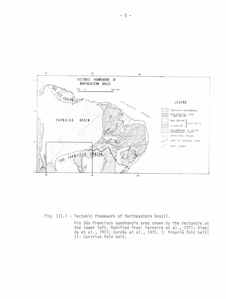
9 - 6 - transcurrent faults. Brito Neves (1973) suggests that these two fold belts be studied together because they belong to a single tectonic unit which develop between neighboring cratonic areas of São Luiz/West Africa to the north and Sío Francisco/Congo to the south. Along the western side of the area shown in Figure is the oriental side of the Paraguay-Araguaia fold belt considered to belong to the Braziliano orogenic cycle (Almeida, 1968) but that probably is older (approximately 2,000 m.y.) according to Amaral (1974). In the southwestern comer of Figure is a region where old structures were rejuvenated during the Braziliano cycle (Almeida et al., 1973). The tectonic evolution of northeastern Brazil during the Paleozoic is characterized by the deposition of the sedimentary sequence of the ParnaTba basin in a stable environment where the São Francisco and Guaporã cratons were their depositional limits (Chignone, 1972).Beginning toward the end of the Jurassic the South American platform was reactivated due to the South Atlantic opening. The consequences of this tectono-magmatic activation have been outlined by Almeida (1972), and comprise the reactivátion of Precambrian structural features, formation of sedimentary basins along the margins of the African and South American plates, intense magmatic activity, and endogenous mineralization as well as the formation of important deposits of oil, gas, sedimentary phosphates, etc. in the
 but that probably is older (approximately 2,000 m.y.) according to Amaral (1974).")
10 -7- taphrpgenic basins. The effects of this tectonic event lasted until the Tertiary and are related to the formation of a marine sedimentary sequence in the marginal basins.

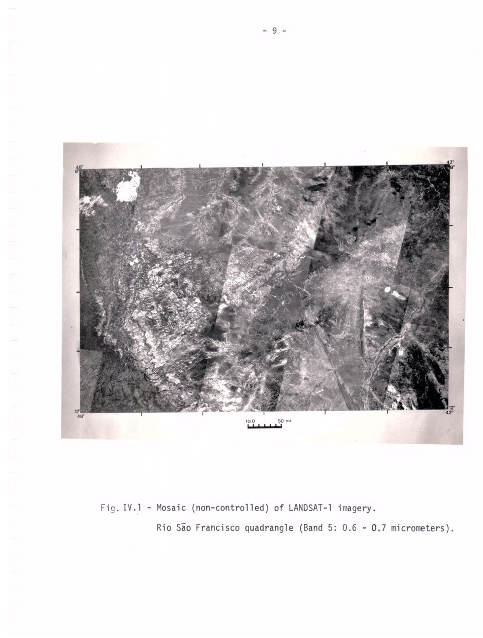
11 - 8 - CHAPTER IV REMOTE SENSING DATA AND INTERPRETATION The procedure followed for the preparation of the 1:1,000,000 geological-structural map of the Rio Sio Francisco consists of three main phases. Firstly, remote sensing data of the area, mainly LANDSAT-1 and SLAR imagery on different scales, were analyzed. Secondly, the photointerpretation was checked during a reconnaissance field work in the area during the month. Thirdly, a reinterpretation of the data was done in order to add the information acquired in the field. The information available from the literature consulted during ali three phases was incorporated into the final map and report. LANDSAT-1's multispectral scanner (MSS) images were the basic data used for the mapping. Most of the imagery was acquired from June to November, during the dry season in the area. A few images without intense cloud cover taken outside this period were used for interpretation. The sun position recorded for the imagery obtained during the dry season changes from 39 0 to 42 0 elevantion angle and 46 0 to 51 0 azimuth during June-July to 57 0 to 58 elevation angle and 85 to 112 azimuth during October-November therefore for some of the areas features which might not have been clearly observed with given illumination condition could have been detected in images obtained on a different date, (Fig. IV.1).

12
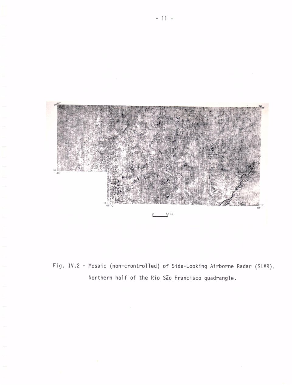
13 SLAR imagery of the northern part of the area was acquired by the Brazilian Geological Survey (DNPM) as part of a radar mapping program (RADAM Project) carried out in northern Brazil, which is presently being extended to the solith. The radar system used was a Goodyear APQ 102 with synthetic aperture antenna, operating in the K-band (3.1 cm wavelength). The flight line is most of the Rio Sgo Francisco quadrangle area were north-south and the imaging direction towards the west, therefore the shadow effect in the radar imagery is similar to that in LANDSAT-1 imagery. In the southeast comer of the area mapped by the SLAR system, the images were obtained during east-west flights (Fig.IV.2). Photographs acquired during SKYLAB missions were also analyzed but since only a few were free of clouds, the results described here are essentially related to the LANDSAT and SLAR imagery.
.")
14
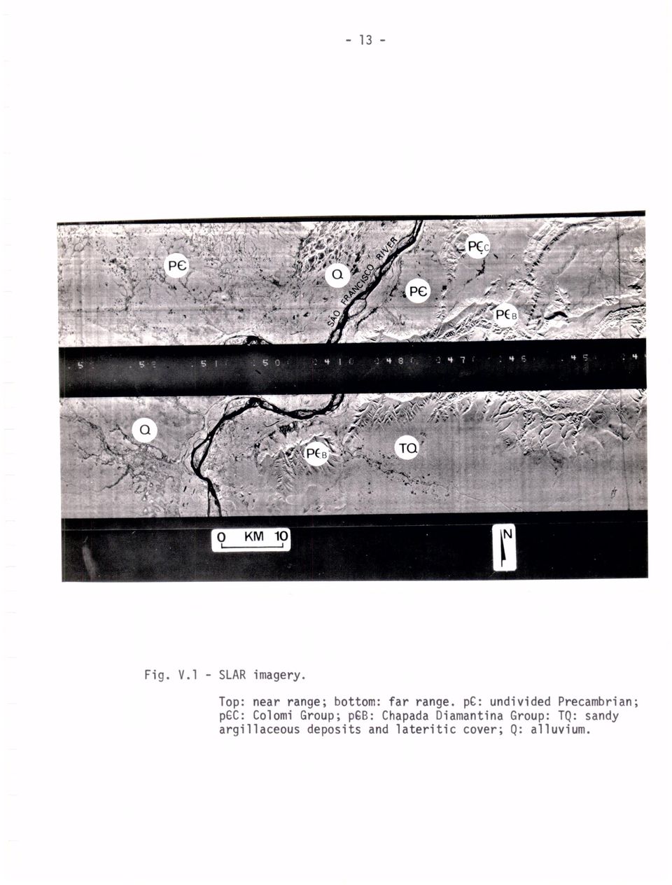
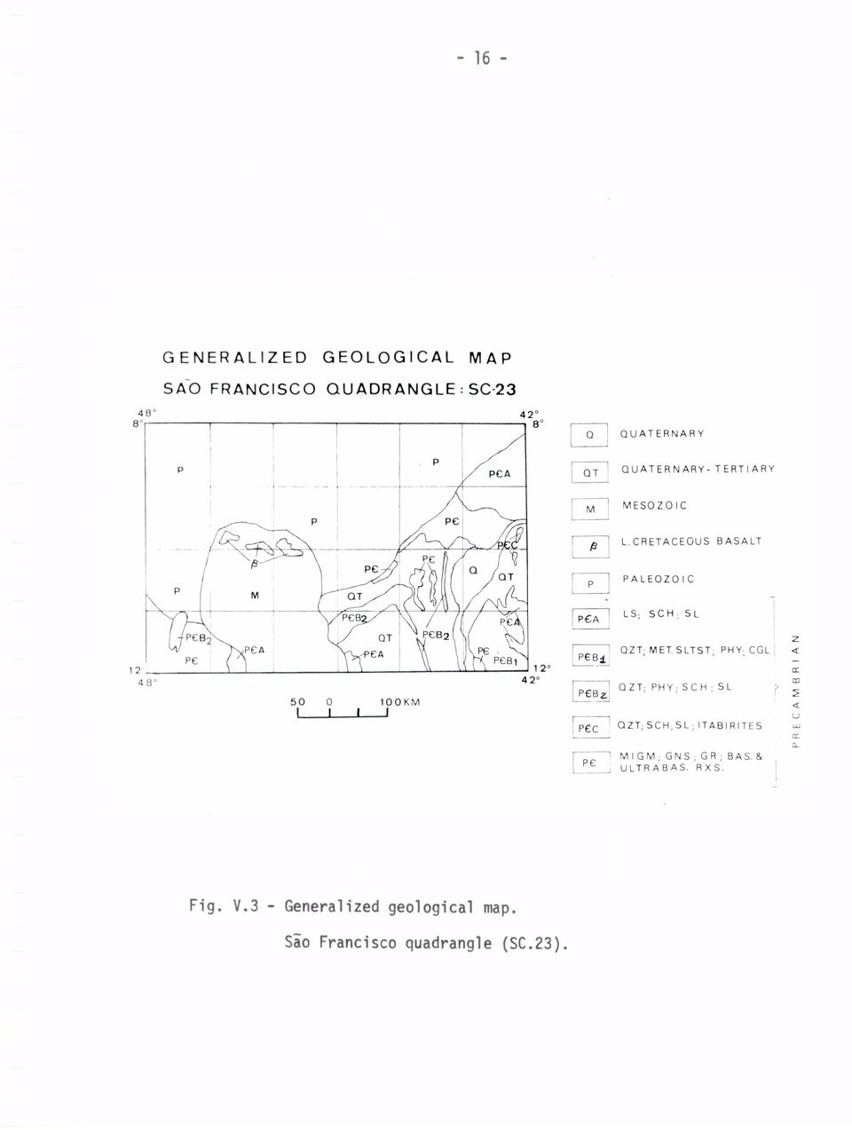
15 CHAPTER V REGIONAL GEOLOGICAL MAPPING Most of the information extracted from LANDSAT-1 and SLAR imagery concerns the structural features present in the area. Lithologies however could be identified with good reliability using mainly LANDSAT-1 data which was combined, when possible, with the information from other sensors. Tone and texture were the main characteristics used to discriminate lithologic units and together with drainage patterns, landforms, vegetation and sou l use patterns led to the identification of "remote sensing rock units". Figures V.1 and V.2 show two lithostratigraphic units (pgc and pgb) defined by essentially the same rock types which cannot be discriminated properly without field control. Thick sedimentary units provide the best opportunity for identification of lithologies mainly if dips are steep to moderate (Lee et al., 1974). In the Rio São Francisco quadrangle area, lithologic units of the Parnaiba basin could be mapped with good precision because of their homogeneous tonal and textura] characteristics usually contrasting with adjacent units. The result - of the initial interpretation of LANDSAT and

16
17

18 SLAR imagery was then compared with existing maps of the area and a revised map incorporated also the results of field work in selected areas was prepared. A generalized geological map of the Rio Sio Francisco quadrangle is presented in figure V.3 while the final map is being drafted. The structural information extracted from small scale imagery, such as those under discussion, presents a basic problem. In many cases it is possible to identify on the ground those structures (i.e. faults, fracture zones, etc.) which account for the linear features detected In the imagery. In some cases however, it is not possible to find a ready explanation for them. Severa.' authors have already indicated that they may be important in the structural analysis of an area (Rich and Steele, 1974); Corrga and Lyon, 1974; Corria et al., 1975), or to define targets for mineral exploration (Nicolais, 1974; Viljoen, 1974). A mosaic of conventional aerial photographs vias used by Kegel (1965) to identify the structural features in northeastern Brazil including the Rio Sio Francisco quadrangle area. The major structural trends of the formations belonging to the Crystalline Complex were observed as well as the limits of large tectonic blocks in the area of the Caririan and Proprii fold belts which are separated by xtensive fracture zones. In the Rio Sio Francisco quadrangle however, a large number of previously unknown structural features were identified which complement Kegel's observations.
 which account for the linear features detected In the imagery. In some cases however, it is not possible to find a ready explanation for them. Severa.")
19
20 -17- Structures observed in LANDSAT and SIAR images with uncertain origin, but certainly including some that are structurally controlled, have been called herein linear features. The term lineament is used to indicate those features related to the geological structure of the area. The other tens used in this paper to identify structures are well defined in structural geology. The structural map of the Rio Sio Francisco quadrangle includes not only the result of the interpretation of remote sensing data, but also those structures identified on the ground and shown in previous maps (Fig. V.4). Some of the structural features already mapped, such as faults and folds, despite their significant size, were not detected in small scale imagery. This is probably due to their small (or lack of) topographic expression and/or lack of contrast in relation to surrounding features in the imagery.
. Some of the structural features already mapped, such as faults and folds, despite their significant size, were not detected in small scale imagery.")
21
22 -19- CHAPTER VI STRUCTURAL INTERPRETATION The structural interpretation presented below is an attempt to identify sets of structures which characterize regional trends and to point out their relationship with other structural systems taking into account the tectonic evolution of the Rio São Francisco quadrangle area. The most important characteristics of the structural features in this area (Fig. V.4 ) are the concentration of fractures (including faults and joints) in areas of the exposed Crystalline Basement and of linear features in areas overlain by thick sedimentary sequences or by alluvium. Folding is not widespread, seeming to be restricted to the areas of the Precambrian Basement, where long anticlines and synclines seem to be a common feature. Some of the structural systems described here have been identified already by other geologists who have worked in the area, and one hopes that this interpretation will encourage not only new structural studies but also the application of remete sensing data in geological research and mineral exploration. The seven structural systems identified in the Rio São Francisco quadrangle area, called São Francisco, Parnarba, Gilbugs,
23 Lizarda, Tocantins-Araguaia, Boqueirão-Estreito and Pernambuco are described in the following paragraphs. The basement of the Sio Francisco craton which is located in the southern part of the area was consolidated before 1,800 m.y. and may have been remobilized to a certain extent during the Trans-Amazonian orogenic cycle (Almeida et al., 1973). This basement is covered by metasedimentary and sedimentary units of the Upper Precambrian, and younger sedimentary units. The areas with a small frequency of structural features are overlain either by a thick Cretaceous sedimentary unit (part of unit M in Fig. V.3) or by alluvium, colluvium and scattered lateritic cover (units Q and QT in Fig. V.3). The structural system called Sio Francisco is characterized by an orthogonal set of long linears trending northeast and northwest. This system may indicate the basic fracture pattern of the Precambrian Basement which might have been rejuvenated during the Trans-Amazonian orogenic cycle (1,800-2,600 m.y.).(fig. VI.1). Pflug et al., (1969) indicate that the structural features and the facies changes observed in the southeastern comer of the area support their idea that two cratons were present before the deposition of sediments along their margin. The identification of the Boqueirão-Estreito structural system within the area of the São Francisco craton seems to support the idea of the Minas orthogeosyncline which developed between the
24
25 São Francisco craton located to the west of the Boqueirão-Estreito zone, and the Lençois craton, located in the southeastern comer of the quadrangle (Pflug et al., 1969). The Boqueirão-Estreito structural system which is characterized by a NNE and a NW trend, could have been the site of collision between two continental plates during Precambrian. The western side of the quadrangle is characterized by a NNW and NE trending system with several NS trending normal faults. These faults which cut the Paleozoic sedimentary sequence of the Parnatba basin are considered to belong to the Tocantins Araguaia structural system (Kegel, 1965; Corria et al., 1975) which was rejuvenated during the Braziliano tectonic cycle ( m.y.). The Parnafba structural system is defined by NE and NW trending sets of orthogonal structures. These structural trends belonging to the Precambrian Basement probably were reactivated during the Mesozoic when the Parnaiba sedimentary basin underwent rapid subsidence as suggested by Almeida (1972). The Gilbugs structural system is characterized by a predominant set of large NW trending structures and a NE trending set of structures concentrated in the central part of the quadrangle. To the north of the 8 parallel, this structural system is defined by the alignement of cryptovolcanic structures, positive structural anomalies, and a large scale thrust fault (Cunha and Carneiro, 1972). Most of the
26 circular features (2-5 km diameter) observed in our study are located along khis structural system which was formed during the Eocambrian (Cunha and Carneiro, 1972) and was reactivated during the Mesozoic. The Lizarda structural system (Correa et al., 1975) with its NE trending structures is an extension of the Sobral-Pedro II lineament detected by Kegel (1965). The Pernambuco structural system which has been identified in the eastern side of the quadrangle probably was formed at the same time as the Lizarda system. Both of them seem to have been active during the Mesozoic (Late Triassic to Cretaceous) as a result of the disruption of the Gondwana continental plate and subsequent fracturing of the South American Atlantic margin. This system is correlated with the Precambrian SW Pernambuco/SE PiauT fold belt (Brito Neves, 1973).
27 CHAPTER VII MINERAL DEPOSITS No large mineral deposits are known in the Rio Sio Francis co quadrangle partly because alluvium, colluvium, and sand deposits cover most of the Precambrian areas. Small mineralizations are known in the east, southeast, and southwest of the quadrangle where Precambrian rock units crop out. Besides those areas, the central part of the Rio Sio Francisco area is the only other region where valuable mineralization has been found GOLO Gold placer deposits are found in the southeastern comer of the quadrangle (Diamantina plateau) but to a lesser extent than in the 1930's and 1940's when gold made well known the districts of Gentio do Ouro, Barra do Mendes, Ipupiara and Central (State of Bahia). Another area where gold has been mined is in the southwestern comer of the quadrangle (Dianapolis and Almas areas, State of Goiís) where gold bearing quartz veins are found in Crystalline Basement rocks. Gold mineralization is so widespread in Precambrian terrains
28 that no controlling factor is evident for the Rio Sio Francisco quadrangle LEAD-ZINC DEPOSITS The limestone sequence of the Bambui group (+ 600 m.y.) which is present In several areas of the quadrangle is an excellent target for exploration for lead and zinc ores not associated with eruptives. Recent studies on the origin of these deposits indicate that they are related to fracture zones (Amaral, 1968) which were percolated by solutions that remobilized and concentrate the metais. A NNE trending crustal weakness zone located along the upper and middle Sio Francisco river (Guimarães,1964) seems to control the location of most lead-zinc ore deposits in eastern Brazil (Cassedane, 1968), This fracture zone is indicated in our study area by the Boqueirão-Estreito structural system which is obliterated to the north by younger systems RUTILE Rutile is produced from placer deposits derived from quartz veins or lenses in quartzites or phyllites of a metasedimentary sequence In the Boqueirão and estreito mountain ranges. Primary concentration of the rutile in the original sedimentary rocks probably is due to the erosion of basic rocks in source areas or to volcanic activity during sedimentation of the host rocks (Winge, 1968).
29 DIAMONDS Diamonds in the southeastern comer of the Rio São Francisco quadrangle originate from the weathering of conglomerate leveis in quartzites of the Diamantina Plateau. In the central area of the Rio São Francisco quadrangle, diamond placers have been mined, In the area of Gilbugs and Monte Alegre (State of PiauT). A Kimberlite discovered 15 km northwest of Gilbugs is being studied to verify if it is the original source of diamonds (Nunes et al., 1973). Other circular structures which could be proven to be ultrabasic rocks have been detected in radar imagery (Nunes et al., 1973) and again during our mapping program and semm to be restricted to the Gilbugs structural system.
30 CHAPTER VIII CONCLUSIONS The results of this regional mapping program show that remote sensing data such as LANDSAT and SLAR imagery are extremely useful to make small scale maps or to revise previous maps with savings in time and money. Some of the structural systems identified in the Rio Sio Francisco quadrangle seem to be directly related to specific types of mineralization and could serve as guides in selecting target areas for exploration.
31 ACKNOWLEDGEMENTS The author acknowledges the help provided by INPE's geologists during the interpretation of remote sensing imagery and field work, especially by Messrs. Paulo R. Meneses, Paulo Veneziani, Athos R. Santos, Ubiratan P. Santos, and Chan C. Liu who drafted several illustrations.
32 REFERENCES ALMEIDA, F.F.M. "Evolução Tect6nica do Centro-oeste Brasileiro no Proterozoico Superior". Anais Academia Brasileira de Cancias s v.40, Suplemen to, p , ALMEIDA, F.F.M. "Geochronological Division of the Precambrian of South America". Revista Bras. de Ceceai:cias, v.1, n9 1, p , ALMEIDA, F.F.M. "Tectono-magmatic Activation of the South American Platform and Associated Mineralization": Internet. Geol. Congress, 24th, sec.3, p , ALMEIDA, F.F.M., AMARAL, G., CORDANI, U.G., and KAWASHITA, K., 1973, "The Precambrian Evolution of the South-American Cratonic Margin South of the Amazon River in the Ocean Basins and Margins", v.1, A.E.M. Main and F.G. Stehli, ed.: N. York Plenum Publ. Corp., p , AMARAL, G. "Contribuição ao Conhecimento dos Der:altos de Zn-Pb-Ag da Ser ra de Poço Verde, Estado de Minas Gerais": Anais do XXII Congresso Brasileiro de Geologia, Belo Horizonte, p AMARAL, G. "Geologia Prí-cambriana da Região Amazinica" - Unpubl. Doctoral thesis at Univ. of são Paulo, 212 p., BRITO NEVES, B.B. "Elementos da Geologia Precambriana do Nordeste Oriental": Paper presented at the XXVII Cong. Brasileiro de Geologia, Araca ju, 56p., BRUNI, M.A.L., ALMEIDA, J.T. and BRUNI, E.C. "Carta Geol6gica do Brasil
33 ao Milionísimo - Folha Rio São Francisco (SC.23)": Brazil, Departamento Nacional da Produção Mineral, map at 1:1,000,000 scale, 57p CASSEDANE, J.P. "Repartition Lineamentaire des Gites de Plomb et de Zinc du Brísil": Anais da Academia Brasileira de Ciáhcias, v.40, suplemento, p CHIGNONE, J,I. "Ensaio de Paleogeologia do Nordeste e as Sequências Sedimentares": Soc. Brasileira dê Geologia, Anais do XXVI Congresso, Belím, 4.3, p CORRÊA, A.C. and LYON, R.J.P. "An Application of Optical Fourier Analysis to the Study of Geological Linear Features in ERTS-1 Imagery in California": Stamford Remote Sensing Lab. Tech. Rept. n9 74-9,34p CORRÊA, A.C., MENDONÇA, F., and LIU, C.C. 'Case StudUs on the Geological Application of LANDSAT imagery in Brazil: São Josí dos Campos, INPE, 1975, INPE-729-PE/006, 32p. CUNHA, F.M.B., and CARNEIRO, R.G. "Interpretação Fotogeológica do Centrooeste da Bacia do Maranhão": Soc. Brasileira de Geologia,Anais dó XXVI Congresso, v.3, p FERREIRA, E.O., ALMEIDA, F.F.M., SUSZCZYNKI, E.F. and DERZE, G.R. "Mapa Tectónico do Brasil": Brazil, Departamento Nacional da Produção Mineral, 1:5,000 scale GUIMARÃES, D., "Geologia do Brasil": Rio de Janeiro, Departamento Nacional da Produção Mineral, 674p., KEGEL, W. "A Estrutura Geol6gica do Nordeste Brasileiro": Brasil, Div.
34 Geol. Miner., Rol. n9 227, 44' LEE, K., KNEPPER, D.H., and SAWATZKY, D.L., "Geologic Information from Satellite Images": Colorado School of Mines, Remote Sensing Report 74-3, 37p., NICOLAIS, S.M., "Mineral Exploration with ERTS Imagery": Third Earth Resources Technology Satellite -1 Symposium, V.1, p , NUNES, A.B., BARROS FILHO, C.N. and LIMA, R. F.F 1973, "Geologia de Par te das Folhas SC.23, Rio São Francisco e SC,24 Aracaju", in Projeto RADAM, v.1: Brazil, Departamento Nacional da Produção Mineral, map at 1:1,000,000 scale, 32p., PFLUG, R., SCHOBBENHAUS, C., and RENGER, F., "Contribuição a Geotectanica do Brasil Oriental (Contribution to the Geotectonics of east Brazil)": Superintendincia do Desenvolvimento dó Nordeste -SUDENE, Div. Geologia, Sêrie Especial n9 9, 59p. RICH, E.I., and STEELE, W.C., 1974, "Speculations on Geologic Structures in Northern California as Detected from ERTS-1 Satellite Imagery": Geology, v.2, n9 4, p VILJOEN, R.P., "ERTS-1 Imagery as an Aid to the understanding of the Regional Setting of Base Metal Deposits in the North West Cape Province, South Africa": Third Earth Resources Technology Satellite -1 Symposium, v.1, p
How Did These Ocean Features and Continental Margins Form?
 298 10.14 INVESTIGATION How Did These Ocean Features and Continental Margins Form? The terrain below contains various features on the seafloor, as well as parts of three continents. Some general observations
Stability Assessment of Chamshir Dam Based on DEM, South West Zagros
 2015 2nd International Conference on Geological and Civil Engineering IPCBEE vol. 80 (2015) (2015) IACSIT Press, Singapore DOI: 10.7763/IPCBEE. 2015. V80. 13 Stability Assessment of Chamshir Dam Based
REPORT OF WORK GUIDELINES
 REPORT OF WORK GUIDELINES The following guidelines apply to a report of work submitted under section 56(1) of the Mining Act (http://laws.gnb.ca/en/showdoc/cs/m-14.1). 1 (1) A report of work shall be submitted
Instituto Superior Técnico
 Instituto Superior Técnico Master Degree in Petroleum Engineering Brazil s Pre-Salt Oil & Gas Exploration (Santos and Campos sedimentary basins) Petroleum Engineering Seminars Presentation by: André Pereira
Structural Geology Laboratory 9 (Name)
") Structural Geology Laboratory 9 (Name) Geologic maps show the distribution of different types of structures and rock stratigraphic units generally on a topographic base such as a quadrangle map. Key structures
Structural Geology Laboratory 9 (Name) Geologic maps show the distribution of different types of structures and rock stratigraphic units generally on a topographic base such as a quadrangle map. Key structures
MINES AND ENERGY MINISTRY OF COLOMBIA. Geological Survey of Colombia National Mineral Agency of Colombia
 MINES AND ENERGY MINISTRY OF COLOMBIA Geological Survey of Colombia National Mineral Agency of Colombia STRATEGIC MINING AREAS AN OPPORTUNITY TO INVEST IN COLOMBIA Toronto, March 2013 AGENDA 1. GEOLOGICAL
LABORATORY TWO GEOLOGIC STRUCTURES
 EARTH AND ENVIRONMENT THROUGH TIME LABORATORY- EES 1005 LABORATORY TWO GEOLOGIC STRUCTURES Introduction Structural geology is the study of the ways in which rocks or sediments are arranged and deformed
THE NEW BRAZILIAN STANDARD FOR SEISMIC DESIGN
 ABSTRACT : THE NEW BRAZILIAN STANDARD FOR SEISMIC DESIGN Sergio Hampshire C. Santos 1 and Silvio de Souza Lima 1 1 Professor, Polytechnic School, Federal University of Rio de Janeiro, Rio de Janeiro, Brazil
Geological Maps 1: Horizontal and Inclined Strata
 Geological Maps 1: Horizontal and Inclined Strata A well-rounded geologist must be familiar with the processes that shape the Earth as well as the rocks and minerals that comprise it. These processes cover
Data Mining and Exploratory Statistics to Visualize Fractures and Migration Paths in the WCBS*
 Data Mining and Exploratory Statistics to Visualize Fractures and Migration Paths in the WCBS* Jean-Yves Chatellier 1 and Michael Chatellier 2 Search and Discovery Article #41582 (2015) Posted February
Plate Tectonics. Plate Tectonics The unifying concept of the Earth sciences. Continental Drift
 Plate Tectonics The unifying concept of the Earth sciences. The outer portion of the Earth is made up of about 20 distinct plates (~ 100 km thick), which move relative to each other This motion is what
Plate Tectonics: Big Ideas. Plate Tectonics. Plate Tectonics. The unifying concept of the Earth sciences.
 Plate Tectonics: Big Ideas Our understanding of Earth is continuously refined. Earth s systems are dynamic; they continually react to changing influences from geological, hydrological, physical, chemical,
The Geology of the Marginal Way, Ogunquit, Maine
 Geologic Site of the Month February, 2002 The Geology of the Marginal Way, Ogunquit, Maine 43 14 23.88 N, 70 35 18.36 W Text by Arthur M. Hussey II, Bowdoin College and Robert G. Marvinney,, Department
3D Inversion of Magnetic Data at Low Magnetic Latitudes Telma Aisengart, Geosoft Latinoamerica Ltda.
 3D Inversion of Magnetic Data at Low Magnetic Latitudes Telma Aisengart, Geosoft Latinoamerica Ltda. Copyright 2013, SBGf - Sociedade Brasileira de Geofísica This paper was prepared for presentation during
Dip is the vertical angle perpendicular to strike between the imaginary horizontal plane and the inclined planar geological feature.
 Geological Visualization Tools and Structural Geology Geologists use several visualization tools to understand rock outcrop relationships, regional patterns and subsurface geology in 3D and 4D. Geological
TECTONICS ASSESSMENT
 Tectonics Assessment / 1 TECTONICS ASSESSMENT 1. Movement along plate boundaries produces A. tides. B. fronts. C. hurricanes. D. earthquakes. 2. Which of the following is TRUE about the movement of continents?
Well-logging Correlation Analysis and correlation of well logs in Rio Grande do Norte basin wells
 Well-logging Correlation Analysis and correlation of well logs in Rio Grande do Norte basin wells Ricardo Afonso Salvador Pernes (March, 2013) ricardo.pernes@ist.utl.pt Master thesis Abstract During drilling
GEL 113 Historical Geology
 GEL 113 Historical Geology COURSE DESCRIPTION: Prerequisites: GEL 111 Corequisites: None This course covers the geological history of the earth and its life forms. Emphasis is placed on the study of rock
Geologic History Review
 1. The climate that existed in an area during the early Paleozoic Era can best be determined by studying (1) the present climate of the area (2) recorded climate data of the area since 1700 (3) present
EXTENSIVE GOLD IN SOILS TARGET IDENTIFIED AT MOMBUCA GOLD PROJECT, SE BRAZIL
 9 July 2015 EXTENSIVE GOLD IN SOILS TARGET IDENTIFIED AT MOMBUCA GOLD PROJECT, SE BRAZIL Open ended target zone up to 1.5km long identified Key Points Prospectivity of Centaurus recently secured Mombuca
A GIS BASED GROUNDWATER MANAGEMENT TOOL FOR LONG TERM MINERAL PLANNING
 A GIS BASED GROUNDWATER MANAGEMENT TOOL FOR LONG TERM MINERAL PLANNING Mauro Prado, Hydrogeologist - SRK Consulting, Perth, Australia Richard Connelly, Principal Hydrogeologist - SRK UK Ltd, Cardiff, United
WILLOCHRA BASIN GROUNDWATER STATUS REPORT 2009-10
 WILLOCHRA BASIN GROUNDWATER STATUS REPORT 2009-10 SUMMARY 2009-10 The Willochra Basin is situated in the southern Flinders Ranges in the Mid-North of South Australia, approximately 50 km east of Port Augusta
1. The diagram below shows a cross section of sedimentary rock layers.
 1. The diagram below shows a cross section of sedimentary rock layers. Which statement about the deposition of the sediments best explains why these layers have the curved shape shown? 1) Sediments were
College of Science and Health ENVIRONMENTAL SCIENCE & GEOGRAPHY Course Outline
 College of Science and Health ENVIRONMENTAL SCIENCE & GEOGRAPHY Course Outline 1. TITLE OF COURSE AND COURSE NUMBER: General Geology ENV 115, 4 credits 2. DESCRIPTION OF THE COURSE: Includes the study
89.215 - FORENSIC GEOLOGY GEOLOGIC TIME AND GEOLOGIC MAPS
 NAME 89.215 - FORENSIC GEOLOGY GEOLOGIC TIME AND GEOLOGIC MAPS I. Introduction There are two types of geologic time, relative and absolute. In the case of relative time geologic events are arranged in
Securing the future of decom
 R E Q U I R E D R E A D I N G F O R T H E G L O B A L O I L & G A S I N D U S T R Y S I N C E 1 9 7 5 AUGUST 2011 Deep thinking on the Latin American beat Floating production tales of the unexpected OFFSHORE
Plate Tectonics: Ridges, Transform Faults and Subduction Zones
 Plate Tectonics: Ridges, Transform Faults and Subduction Zones Goals of this exercise: 1. review the major physiographic features of the ocean basins 2. investigate the creation of oceanic crust at mid-ocean
Structural Origin of the Claremont Anticline, Nova Scotia: Has new seismic solved an old problem?
 Structural Origin of the Claremont Anticline, Nova Scotia: Has new seismic solved an old problem? J.P.(Paddy) Chesterman Devon Canada Corporation, 301 400-3rd Avenue SW, Calgary, AB, T2P 4H2 paddy.chesterman@devoncanada.com
Hot Spots & Plate Tectonics
 Hot Spots & Plate Tectonics Activity I: Hawaiian Islands Procedures: Use the map and the following information to determine the rate of motion of the Pacific Plate over the Hawaiian hot spot. The volcano
Industrial area with Hangar. Land area: 90.000 sqm Hangar area: 5.000 sqm Office area: 250 sqm Brazil Espírito Santo Serra Highway BR 101 North
 Industrial area with Hangar Land area: 90.000 sqm Hangar area: 5.000 sqm Office area: 250 sqm Brazil Espírito Santo Serra Highway BR 101 North Property Location Brasil, Espírito Santo, Serra - Highway
Seismostratigraphy Sequence Model of the Rio Grande Cone, Brazil*
 Seismostratigraphy Sequence Model of the Rio Grande Cone, Brazil* Luis Castillo 1, Thais Kazmierczak 1,2, Marvick Ruiz 1, and Farid Chemale 3 Search and Discovery Article #30206 (2011) Posted November
Using LIDAR to monitor beach changes: Goochs Beach, Kennebunk, Maine
 Geologic Site of the Month February, 2010 Using LIDAR to monitor beach changes: Goochs Beach, Kennebunk, Maine 43 o 20 51.31 N, 70 o 28 54.18 W Text by Peter Slovinsky, Department of Agriculture, Conservation
Chesapeake Bay Governor School for Marine and Environmental Science
 Choose the best answer and write on the answer sheet provided. 1. Which of the following is LEAST likely to be an effect of global warming? (a) Loss of fertile delta regions for agriculture (b) Change
MAJOR AND TRACE ELEMENTS IN GEOLOGICAL SAMPLES FROM ITINGUSSÚ BASIN IN COROA-GRANDE, R J.
 2005 International Nuclear Atlantic Conference - INAC 2005 Santos, SP, Brazil, August 28 to September 2, 2005 ASSOCIAÇÃO BRASILEIRA DE ENERGIA NUCLEAR - ABEN ISBN: 85-99141-01-5 MAJOR AND TRACE ELEMENTS
Zion National Park Slot Canyons
 UWEC Zion National Park Slot Canyons Slot Canyon Formation Tubbs Beaudette, Mary Frances 10/12/2012 (Butler, 2007, Antelope Canyon, Zion National Park) Table of Contents Abstract 1 Introduction 1 Bedrock
Rb-Sr AND K-Ar AGES FOR PEGMATITES FROM THE BANABUIÚ REGION, BORBOREMA PROVINCE, BRAZIL.
 Rb-Sr AND K-Ar AGES FOR PEGMATITES FROM THE BANABUIÚ REGION, BORBOREMA PROVINCE, BRAZIL. Martha Noélia Lima 1 Maria do Rosário Azevedo 1 José de Araújo Nogueira Neto 2 Gabriela Meireles Rosa 2 Umberto
ACQUIRING MINERAL RIGHTS IN THE NORTHWEST TERRITORIES
 ACQUIRING MINERAL RIGHTS IN THE NORTHWEST TERRITORIES Introduction Establishing and maintaining strong working relationships between the mineral industry and Northwest Territories (NWT) residents and community
Chapter 2. Plate Tectonics. Plate Tectonics: Learning Goals
 Plate Tectonics Chapter 2 Interactions at depend on the direction of relative plate motion and the type of crust. Which kind of plate boundary is associated with Earthquake activity? A. Divergent Boundary
Introduction to Structural Geology
 Introduction to Structural Geology Workbook 3 Geological Maps BGS Introduction to geological maps 4 1. Outcrop patterns on geological maps 7 2. Cross sections 16 3. Structure contours 22 cknowledgements
Deep geological disposal of radioactive waste in Switzerland - overview and outlook
 Deep geological disposal of radioactive waste in Switzerland - overview and outlook Michael Schnellmann (Section Head Geosciences) Annual Convention 2015 Baden 20 th June 2015 Nagra Mandate from the Swiss
RAINBOW AURORA INDIAN PROPERTIES Goodpaster Mining District, Alaska
 RAINBOW AURORA INDIAN PROPERTIES Goodpaster Mining District, Alaska Prepared by: Carl Schaefer CPG# 10834 Northern Associates, Inc. February, 2006 Tonogold Resources, Inc. 5771 La Jolla Boulevard La Jolla,
Pacifico set to commence drilling at Borroloola West Project and co-funding secured from NT Government
 CORPORATE DIRECTORY Managing Director Simon Noon Directors Richard Monti (Chairman) Peter Harold (Non-exec.) Andrew Parker (Non-exec.) Company Secretary Joshua Ward Patrick Holywell Registered office Level
Groundwater Potential of Basement Aquifers in Part of Southwestern Nigeria
 American International Journal of Contemporary Research Vol. 3 No. 3; March 2013 Groundwater Potential of Basement Aquifers in Part of Southwestern Nigeria Yinusa Ayodele Asiwaju-Bello Department of Marine
Week 1. Week 2. Week 3
 Week 1 1. What US city has the largest population? 2. Where is Aachen? 3. What is the capitol of Florida? 4. What is the longest mountain range in Spain? 5. What countries border Equador? Week 2 1. What
2008-2009 PROSPECTING REPORT. Ghost Lake Serpentine Property. EVENT # 4282919 TENURE # 558949 Tenure Name: Ghost Lake Serpentine
 2008-2009 PROSPECTING REPORT Ghost Lake Serpentine Property EVENT # 4282919 TENURE # 558949 Tenure Name: Ghost Lake Serpentine New Westminster Mining Division Map 092H Central Coordinate Reference 121
Rocks & Minerals. 10. Which rock type is most likely to be monomineralic? 1) rock salt 3) basalt 2) rhyolite 4) conglomerate
 rock salt 3) basalt 2) rhyolite 4) conglomerate") 1. Of the Earth's more than 2,000 identified minerals, only a small number are commonly found in rocks. This fact indicates that most 1) minerals weather before they can be identified 2) minerals have
1. Of the Earth's more than 2,000 identified minerals, only a small number are commonly found in rocks. This fact indicates that most 1) minerals weather before they can be identified 2) minerals have
GEOLOGIC MAPS. PURPOSE: To be able to understand, visualize, and analyze geologic maps
 GEOLOGIC MAPS PURPOSE: To be able to understand, visualize, and analyze geologic maps Geologic maps show the distribution of the various igneous, sedimentary, and metamorphic rocks at Earth s surface in
Location and Distance on Earth (Chapter 22 part 1)
") GEOLOGY 306 Laboratory Instructor: TERRY J. BOROUGHS NAME: Location and Distance on Earth (Chapter 22 part 1) For this assignment you will require: a calculator, protractor, and a metric ruler, and an
GEOLOGY 306 Laboratory Instructor: TERRY J. BOROUGHS NAME: Location and Distance on Earth (Chapter 22 part 1) For this assignment you will require: a calculator, protractor, and a metric ruler, and an
Active and Passive Microwave Remote Sensing
 Active and Passive Microwave Remote Sensing Passive remote sensing system record EMR that was reflected (e.g., blue, green, red, and near IR) or emitted (e.g., thermal IR) from the surface of the Earth.
Earth Science & Environmental Science SOL
 Earth Science & Environmental Science SOL THE SOL FOR GRADE 6 The Virginia Science SOL for Grades K 6 are organized according to a set of strands, with the SOL in each strand developed progressively through
GEOLOGICAL REINTERPETATION LEADS TO MAJOR DRILL PROGRAM AT JUPITER
 GEOLOGICAL REINTERPETATION LEADS TO MAJOR DRILL PROGRAM AT JUPITER Dacian Gold Ltd ( Dacian or the Company ) (ASX:DCN) is pleased to announce that it has completed a major geological review and reinterpretation
MOMBUCA GOLD PROJECT: STRONG GOLD GRADES FROM TRENCHING CONFIRM PRESENCE OF STACKED QUARTZ VEIN SYSTEM
 2 February 2016 MOMBUCA GOLD PROJECT: STRONG GOLD GRADES FROM TRENCHING CONFIRM PRESENCE OF STACKED QUARTZ VEIN SYSTEM Grades of up to 3.1 g/t Au from new trenching program; Induced Polarisation (IP) survey
Geology 200 Getting Started...
 Geology 200 Getting Started... Name This handout should be completed and become a part of your Notebook for this course. This handout is intended to be a review of some important ideas from your introductory
6.E.2.2 Plate Tectonics, Earthquakes and Volcanoes
 Name: Date: 1. The road shown below was suddenly broken by a natural event. 3. The convergence of two continental plates would produce Which natural event most likely caused the crack in the road? island
Metamorphic rocks are rocks changed from one form to another by intense heat, intense pressure, and/or the action of hot fluids.
 Metamorphic Rocks, Processes, and Resources Metamorphic rocks are rocks changed from one form to another by intense heat, intense pressure, and/or the action of hot fluids. Protolith or parent rock is
If you require assistance in obtaining access to the presentations or have questions regarding the. 6300 or Glenn Young at (916) 341 6696.
 341 6696.") These materials were developed by CalRecycle staff to address specific technical training areas and are posted as reference documents for the local l government and CalRecycle staff who work on closed,
These materials were developed by CalRecycle staff to address specific technical training areas and are posted as reference documents for the local l government and CalRecycle staff who work on closed,
 Paleoenvironmental reconstruction of Cretaceous rocks of the Amazonas Basin: preliminary researches MSc. Anderson Mendes Programa de Pós Graduação em Geologia e Geoquímica - IG - UFPA Grupo de Análise
Information Contents of High Resolution Satellite Images
 Information Contents of High Resolution Satellite Images H. Topan, G. Büyüksalih Zonguldak Karelmas University K. Jacobsen University of Hannover, Germany Keywords: satellite images, mapping, resolution,
Analysis of Landsat ETM+ Image Enhancement for Lithological Classification Improvement in Eagle Plain Area, Northern Yukon
 Analysis of Landsat ETM+ Image Enhancement for Lithological Classification Improvement in Eagle Plain Area, Northern Yukon Shihua Zhao, Department of Geology, University of Calgary, zhaosh@ucalgary.ca,
LANDFORMS OF THE EARTH STD VIII
 LANDFORMS OF THE EARTH STD VIII 1) What do you understand by the term geomorphology? A) Geomorphology is the systematic study of the Earth s relief features. Geo means earth; morph meaning form and ology
Focus Earth The Velingara Circular Structure A meteorite impact crater?
 Focus Earth The Velingara Circular Structure A meteorite impact crater? S. Wade Institut des Sciences de la Terre, Faculté des Sciences et Techniques, Université Cheikh Anta Diop, Dakar-Fann, Sénégal M.
Stage 4. Geography. Blackline Masters. By Karen Devine
 1 Devine Educational Consultancy Services Stage 4 Geography Blackline Masters By Karen Devine Updated January 2010 2 This book is intended for the exclusive use in NSW Secondary Schools. It is meant to
ELEMENTS OF SURVEYING FOR CADASTRAL MAPPING
 ELEMENTS OF SURVEYING FOR CADASTRAL MAPPING Chapter 4 2015 Cadastral Mapping Manual 4-0 Elements of Surveying and Mapping Utah's system of land surveying is the rectangular survey system as set forth on
INTERPRETATION ADDENDUM CANADIAN MINING COMPANY INC. SUITE 2300-1066 WEST HASTINGS STREET VANCOUVER, BC V6E 3X2 3D INDUCED POLARIZATION
 INTERPRETATION ADDENDUM FOR CANADIAN MINING COMPANY INC. SUITE 2300-1066 WEST HASTINGS STREET VANCOUVER, BC V6E 3X2 3D INDUCED POLARIZATION ON THE SAN BERNARDO PROJECT EL GOCHICO GRID Approximate Location:
Appendix B. Introduction to Landslide Evaluation Tools Mapping, Remote Sensing, and Monitoring of Landslides
 Appendix B. Introduction to Landslide Evaluation Tools Mapping, Remote Sensing, and Monitoring of Landslides 66 The Landslide Handbook A Guide to Understanding Landslides Part 1. Mapping Maps are a useful
Chapter Overview. Bathymetry. Measuring Bathymetry. Echo Sounding Record. Measuring Bathymetry. CHAPTER 3 Marine Provinces
 Chapter Overview CHAPTER 3 Marine Provinces The study of bathymetry charts ocean depths and ocean floor topography. Echo sounding and satellites are efficient bathymetric tools. Most ocean floor features
How To Create A 3D Model Of The Phanerozoic Succession In Southern Manitoba
 3D GEOLOGICAL MAPPING IN MANITOBA MOVING FORWARD Greg Keller (greg.keller@gov.mb.ca), Gaywood Matile, Manitoba Geological Survey (RET), Canada Harvey Thorleifson, Minnesota Geological Survey, United States
Laboratory #8: Structural Geology Thinking in 3D
 Name: Lab day: Tuesday Wednesday Thursday ENVG /SC 10110-20110L Planet Earth Laboratory Laboratory #8: Structural Geology Thinking in 3D http://www.nd.edu/~cneal/physicalgeo/lab-structural/index.html Readings:
Continental Drift. Alfred Wegener (1880-1930) Proposed that all of the continents were once part of a large supercontinent - Pangaea Based on:
 Proposed that all of the continents were once part of a large supercontinent - Pangaea Based on:") Plate Tectonics and Continental Drift Continental Drift Alfred Wegener (1880-1930) Proposed that all of the continents were once part of a large supercontinent - Pangaea Based on: Similarities in shorelines
Plate Tectonics and Continental Drift Continental Drift Alfred Wegener (1880-1930) Proposed that all of the continents were once part of a large supercontinent - Pangaea Based on: Similarities in shorelines
Continental Drift, Sea Floor Spreading and Plate Tectonics
 Page 1 of 13 EENS 1110 Tulane University Physical Geology Prof. Stephen A. Nelson Continental Drift, Sea Floor Spreading and Plate Tectonics This page last updated on 26-Aug-2015 Plate Tectonics is a theory
ROMANIAN PANNONIAN BASIN Outstanding Opportunity
 ROMANIAN PANNONIAN BASIN Outstanding Opportunity Introduction East West Petroleum Corporation (EWP) is a Vancouver-based, public E&P company, focused on investing in emerging international E&P projects
Francisco Edson M. Gomes Geologist CPRM Geological Survey of Brazil
 Francisco Edson M. Gomes Geologist CPRM Geological Survey of Brazil Area BACKGROUND The Atlas of the South Atlantic Ocean Data organized in GIS was designed by the Geological Survey of Brazil (CPRM) and
3D Visualization of Seismic Activity Associated with the Nazca and South American Plate Subduction Zone (Along Southwestern Chile) Using RockWorks
 Using RockWorks") 3D Visualization of Seismic Activity Associated with the Nazca and South American Plate Subduction Zone (Along Southwestern Chile) Using RockWorks Table of Contents Figure 1: Top of Nazca plate relative
3D Visualization of Seismic Activity Associated with the Nazca and South American Plate Subduction Zone (Along Southwestern Chile) Using RockWorks Table of Contents Figure 1: Top of Nazca plate relative
Geol 101: Physical Geology PAST EXAM QUESTIONS LECTURE 4: PLATE TECTONICS II
 Geol 101: Physical Geology PAST EXAM QUESTIONS LECTURE 4: PLATE TECTONICS II 4. Which of the following statements about paleomagnetism at spreading ridges is FALSE? A. there is a clear pattern of paleomagnetic
Rosaly Lopes, Jet Propulsion Laboratory, California Institute of Technology
 Saturn s Moon Titan: Cassini-Huygens Reveals a New World Rosaly Lopes, Jet Propulsion Laboratory, California Institute of Technology The year 2005 will be remembered in the history of space exploration
DYNAMIC CRUST: Unit 4 Exam Plate Tectonics and Earthquakes
 DYNAMIC CRUST: Unit 4 Exam Plate Tectonics and Earthquakes NAME: BLOCK: DATE: 1. Base your answer to the following question on The block diagram below shows the boundary between two tectonic plates. Which
Metadata for Big River Watershed Geologic and Geomorphic Data
 Metadata for Big River Watershed Geologic and Geomorphic Data Metadata are descriptions and information regarding compiled data. This appendix contains the metadata that describes the compiled data used
Using Remotely Sensed Data From ASTER to Look Impact of Recent Earth Quakes in Gujarat, India.
 Using Remotely Sensed Data From ASTER to Look Impact of Recent Earth Quakes in Gujarat, India. A major earth quake occurred in Gujarat, India on January 26,2000. (Origin time 03:16 GMT, Location 23.399N
Teaching the Dynamic Earth Plate Tectonics Interactive Master sheets
 Teaching the Dynamic Earth Plate Tectonics Interactive Master sheets Contents Page Master Sheets for continental jigsaws Gondwanaland continents (blank outlines)...2 Four continents, showing gaps and overlap
For personal use only
 Investigator Resources Limited Date: 7 th February 2012 up to 2.25% Ag at the new Paris prospect in South Australia First assays received for new drilling on Paris Line 7 with all three holes assayed returning
Session No. 184. Tuesday, 3 November 2015: 8:00 AM- 12:00 PM.
 FROM NEOPROTEROZOIC PRE-CURSOR CLAMS TO THE KLAMATHS: DOCUMENTING THE PALEOGEOGRAPHIC EVOLUTION OF THE EASTERN KLAMATH TERRANES, AN EDUCATION OUTREACH MODEL ROBERTI, Gina M.1, ROTH, John2 and LEDFORD,
1) Summary of work performed and progress made during preceding month
 Summary of work performed and progress made during preceding month") Mapping and Characterization of Recurring Spring Leads and Landfast Ice in the Chukchi and Beaufort Seas, Coastal Marine Institute Project (NOFA MMS09HQPA0004T) Monthly progress report, June 2010 1) Summary
Mapping and Characterization of Recurring Spring Leads and Landfast Ice in the Chukchi and Beaufort Seas, Coastal Marine Institute Project (NOFA MMS09HQPA0004T) Monthly progress report, June 2010 1) Summary
The Next Generation Science Standards (NGSS) Correlation to. EarthComm, Second Edition. Project-Based Space and Earth System Science
 Correlation to. EarthComm, Second Edition. Project-Based Space and Earth System Science") The Next Generation Science Standards (NGSS) Achieve, Inc. on behalf of the twenty-six states and partners that collaborated on the NGSS Copyright 2013 Achieve, Inc. All rights reserved. Correlation to,
The Next Generation Science Standards (NGSS) Achieve, Inc. on behalf of the twenty-six states and partners that collaborated on the NGSS Copyright 2013 Achieve, Inc. All rights reserved. Correlation to,
The El Centenario Au-Ag Project
 Municipality of Santiago Papasquiero State of Durango, Mexico By: Alain R. Charest President and CEO of Arcelia Gold Corp Thursday, 5 th of May 2011 El Centenario Location of the El Centenario Project
ES Chapter 10 Review. Name: Class: Date: Multiple Choice Identify the choice that best completes the statement or answers the question.
 Name: Class: Date: ES Chapter 10 Review Multiple Choice Identify the choice that best completes the statement or answers the question. 1. Scientists used the pattern of alternating normal and reversed
For personal use only
 January, 202 Silver Swan Group Limited December 20 Quarterly Activities Report HIGHLIGHTS STAKEWELL Gold Project: Drilling intersected high and low grade gold mineralisation at Kohinoor, including surface
GROUND-PENETRATING RADAR SURVEY
 GROUND-PENETRATING RADAR SURVEY BANTEAY CHHMAR, CAMBODIA. For the Global Heritage Fund Till F. Sonnemann Archaeological Prospection Group, University of Sydney December 2009 EXECUTIVE SUMMARY Till Sonnemann
Questions & Answers Proposed for Exam #3
 Questions & Answers Proposed for Exam #3 GE50 Introduction to Physical Geology (Geology for Engineers) Missouri University of Science and Technology Fall Semester 2007, Leslie Gertsch (GertschL@mst.edu)
The CO2 Geological Storage: how it works Salvatore Lombardi
 The CO2 Geological Storage: how it works Salvatore Lombardi Carbonia, Centro Ricerche Sotacarbo, 27 novembre 2014 Contents of the presentation Notes on CO2 Geological Storage (CGS) How it works How we
45 mm A MULTIPROXY APPROACH OF THE LATE HOLOCENE EVOLUTION OF THE PARATI-MIRIM RIA, SOUTHERN COAST OF THE RIO DE JANEIRO STATE, BRAZIL
 A MULTIPROXY APPROACH OF THE LATE HOLOCENE EVOLUTION OF THE PARATI-MIRIM RIA, SOUTHERN COAST OF THE RIO DE JANEIRO STATE, BRAZIL Sousa, S.H.M. 1 ; Nagai, R.H. 1 ; Yamashita, C. 1 ; Endo, C.A.K. 1 ; Salaroli,
How To Prepare A Geotechnical Study For A Trunk Sewer Project In Lincoln, Nebraska
 APPENDIX B Geotechnical Engineering Report GEOTECHNICAL ENGINEERING REPORT Preliminary Geotechnical Study Upper Southeast Salt Creek Sanitary Trunk Sewer Lincoln Wastewater System Lincoln, Nebraska PREPARED
Tectonic plates push together at convergent boundaries.
 KEY CONCEPT Plates converge or scrape past each other. BEFORE, you learned Plates move apart at divergent boundaries In the oceans, divergent boundaries mark where the sea floor spreads apart On land,
How To Understand The History Of The American Gold Mine
 September 12, 2011 THE ATLANTA GOLD MINE, EASTERN NEVADA Gold Exploration in Nevada with Near-Term Production Potential TSXV: MAY OTCQX:MAYGF Atlanta Gold & Silver Mine, Nevada Atlanta is located in northeastern
1. You are about to begin a unit on geology. Can anyone tell me what geology is? The study of the physical earth I.
 PLATE TECTONICS ACTIVITY The purpose of this lab is to introduce the concept of plate tectonics and the formation of mountains. Students will discuss the properties of the earth s crust and plate tectonics.
YAMANA GOLD ANNOUNCES SIGNIFICANT NEW DISCOVERIES AT CHAPADA AND EL PEÑÓN IMPROVE OPERATIONAL OUTLOOK
 YAMANA GOLD ANNOUNCES SIGNIFICANT NEW DISCOVERIES AT CHAPADA AND EL PEÑÓN IMPROVE OPERATIONAL OUTLOOK TORONTO, ONTARIO, December 15, 2014 YAMANA GOLD INC. (TSX:YRI; NYSE:AUY) ( Yamana or the Company )
The National Parks of Brazil.
 The National Parks of Brazil. by Ariane Janér Instituto EcoBrasil Agulhas Negras Itatiaia National Park Bengt Janér Of Brazil s more than 300 conservation units, 64 are National Parks. The national parks
CARBONATE VS SILICICLASTIC DEPOSITIONAL SYSTEMS: A FIELD TRIP GUIDE TO MODERN SEDIMENTARY ENVIRONMENTS AND THE GEOLOGY OF BOCAS DEL TORO, PANAMA
 CARBONATE VS SILICICLASTIC DEPOSITIONAL SYSTEMS: A FIELD TRIP GUIDE TO MODERN SEDIMENTARY ENVIRONMENTS AND THE GEOLOGY OF BOCAS DEL TORO, PANAMA Luis Ignacio Quiroz, Jaime Escobar, Cindy Gonzales, Edward
Unit 2 Lesson 4 The Geologic Time Scale. Copyright Houghton Mifflin Harcourt Publishing Company
 Once Upon a Time How have geologists described the rate of geologic change? Geology is the scientific study of the origin, history, and structure of Earth and the processes that shape it. Early geologists
Landslide hazard zonation using MR and AHP methods and GIS techniques in Langan watershed, Ardabil, Iran
 Landslide hazard zonation using MR and AHP methods and GIS techniques in Langan watershed, Ardabil, Iran A. Esmali Ouri 1* S. Amirian 2 1 Assistant Professor, Faculty of Agriculture, University of Mohaghegh
 13º Encontro Sociedade Brasileira de Geofísica 2013 Rio de Janeiro, 26-29 29 August Earthquake Mitigation in the Lisbon and Lower Tagus Valley area, Portugal 1 J. Carvalho, R. Dias, C. Pinto, T. Cunha,