BLM seeks public input on Paria Canyon-Coyote Buttes Draft Business Plan Plan proposes streamlined reservation system, adjusted fees
|
|
|
- Norman Black
- 8 years ago
- Views:
Transcription
1 For Immediate Release: July 8, 2015 Contact: Rachel Carnahan, Public Affairs Specialist Phone: or BLM seeks public input on Paria Canyon-Coyote Buttes Draft Business Plan Plan proposes streamlined reservation system, adjusted fees ST. GEORGE, Utah The Bureau of Land Management (BLM) Arizona Strip District Office is seeking public comment on a plan to streamline the permit reservation process and adjust fees for areas located within and adjacent to Vermilion Cliffs National Monument, including the popular geologic formation known as the Wave. The Paria Canyon-Coyote Buttes Draft Business Plan was developed to balance customer-friendly visitor access with managing impacts to the ecologically unique and remote areas within the Paria Canyon-Vermilion Cliffs Wilderness, amid skyrocketing public interest in the areas. Since 2008, we ve seen a significant rise in visitor interest in these areas, including a 400 percent increase in the number of people seeking permits to access the Wave, said Arizona Strip Field Manager Lorraine Christian. Based on visitor feedback, we determined it was time to review our business plan in order to provide improved customer service while also ensuring the public continues to enjoy a safe and pristine experience in these areas. The BLM proposal would align customer service with a presidential directive to provide online recreation services, transitioning all permit operations for Paria Canyon Overnight, Coyote Buttes North (including the Wave) and Coyote Buttes South to a single, streamlined reservation portal on the Recreation.gov website, beginning in early Currently, 20 people are allowed into each of these sites daily, with high-demand permits to Coyote Buttes North split evenly between an advance online lottery and a next-day, walk-in lottery. The plan would eliminate the existing next-day, walk-in lottery for Coyote Buttes North and move to a 48-hour online lottery, thus providing people planning visits to the Arizona Strip and Southern Utah advance knowledge of whether they can obtain permits. The system will also offer reliable, one-stop travel planning for visitors as they book reservations for visits to multiple public lands and national parks in the region. Moving the system to Recreation.gov will also free BLM staff to provide critical face-to-face safety and weather updates to visitors.

2 Under the proposed plan, fees would also change for each of the units. Fees have not changed since they were established in The proposed permit fee change for Paria Canyon Overnight is from $5 per person per night to $10 per person per night. The existing fee for Wire Pass, Buckskin Gulch, and Paria Canyon Day-Use is $6 per person per day. The proposed fee would decrease to $5 per person per day. The proposed fee change for Coyote Buttes North and South is from $7 and $5 per person per day, respectively, to $12 per person per day for each area. The camping fee at White House Campground would increase to $10, up from $5, per night per site. A $6 service fee would also be charged by Recreation.gov for each permit issued. The revised business plan does not address adjusting the number of permits issued per day. Our goal as stewards of these spectacular public lands is to provide superior customer service and safe access for our visitors, while also ensuring these wilderness areas remain pristine for the enjoyment of current and future generations, Christian said. The fees we collect stay in the area and therefore directly benefit the customer service we can provide visitors. The public is invited to provide feedback on the permit process and proposed fee adjustments, both of which are addressed in the Paria Canyon-Canyon Buttes Special Management Area Draft Business Plan, by August 17. Comments may be provided by mail or in person at 345 East Riverside Drive, St. George, UT or via to blm_az_vcnm@blm.gov. To view a copy of the Business Plan and for more information on the Paria Canyon-Coyote Buttes Special Recreation Area, go to: -BLM- The BLM manages more than 245 million acres of public land, the most of any Federal agency. This land, known as the National System of Public Lands, is primarily located in 12 Western states, including Alaska. The BLM also administers 700 million acres of sub-surface mineral estate throughout the nation. The BLM's mission is to manage and conserve the public lands for the use and enjoyment of present and future generations under our mandate of multiple-use and sustained yield. In Fiscal Year 2014, the BLM generated $5.2 billion in receipts from public lands.

3 Paria Canyon-Coyote Buttes Draft Business Plan Frequently Asked Questions (FAQs) What is the Paria Canyon-Coyote Buttes Special Management Area? The Paria Canyon-Coyote Buttes Special Management Area is located within the Paria Canyon- Vermilion Cliffs Wilderness and comprises three distinct areas: Paria Canyon Overnight (including Buckskin Gulch and Wire Pass), Coyote Buttes North (The Wave), and Coyote Buttes South. Because of the high demand to access these areas, all three require separate access permits so that natural resources and wilderness characteristics are protected. For day use access in Paria Canyon, Buckskin Gulch, and Wire Pass, visitors can use self-pay envelopes at the trailheads. Why are you preparing a Draft Business Plan? Since 2008, the BLM has experienced a 400 percent increase in the number of visitors seeking permits to access the Wave, as well as an increase in visitor demand for other areas in the SMA. With that higher demand comes an increase in associated management costs. Based on customer feedback, the BLM determined it was necessary to reevaluate our business plan in order to provide better customer service and to ensure the public continues to enjoy a pristine experience in this wilderness area. As part of our commitment to our stakeholders, we are providing the Draft Business Plan to share proposed changes in our permit delivery system and fee structure. Under this public process, we welcome public input into our proposed changes. No final decision will be made until we have reviewed stakeholders input. Why does the BLM limit visitor use in Paria Canyon-Coyote Buttes? High visitor demand, combined with the fragile and delicate geologic features in the area, impacts the wilderness character of the area. Overcrowding can degrade an otherwise memorable hiking trip. The visitor use limits are intended to meet resource management goals while preserving a pristine wilderness experience for visitors to this unique and special place. For this reason, 20 persons total are allowed into each Coyote Buttes North and Coyote Buttes South. This is the total from all trailheads/access points for each permit area. 20 people per day are also allowed access to camp overnight in Paria Canyon from all trailheads. There are no visitor use limits for day-use in Paria Canyon, Buckskin Gulch, and Wire Pass. Why are you switching the current online permitting system to an outside source? Recreation.gov offers one-stop travel planning for people interested in visiting public lands across the United States. By using Recreation.gov for issuing permits to the Paria Canyon- Coyote Buttes SMA, the BLM will be able to better serve the public. Recreation.gov is better

4 equipped to keep up with changing technology and to deal with security concerns related to privacy information, since e-commerce is its specialty. Recreation.gov s call center will be available to help customers 24 hours a day, 7 days/week. Currently, a significant amount of BLM staff time and resources are being spent administering permits. This transition will free up BLM staff time to interact more one-on-one with the public and manage the public lands. What is Recreation.gov? Recreation.gov is a website that is operated by Active Network (government contractor) and operates as a one-stop shopping center for a variety of recreation reservations and permits on public lands. There is a large amount of recreation information and help available at this site. When would the new system go into effect? The transition to Recreation.gov is tentatively scheduled to go live in phases beginning April 1, The first phase will start with the advance online permits for Coyote Buttes North and South, and Paria Canyon Overnight. The 48-hour online lottery and calendar for Coyote Buttes North and South will go live March 15, How will the online permitting work? The new system will be similar to the old system. The biggest change will be the elimination of the live walk-in lottery in Kanab, Utah, for Coyote Buttes North and no over-the-counter purchases for Coyote Buttes South. The system will implement a 48-hour online lottery for Coyote Buttes North, which includes the Wave. Previously, 10 of the 20 daily permits were issued via an advanced online lottery and the remaining 10 daily permits were issued during a live walk-in lottery. How do the semi-annual and 48-hour lotteries for Coyote Buttes North (including the Wave) work? Permits for Coyote Buttes North will be issued via two methods: a semi-annual lottery and a daily, 48-hour lottery. For the semiannual lottery, the public will have two months to enter the lotteries that will run on December 1 and June 1 for the months of January 1-June 30 and July 1-December 31, respectively. Application periods will be October 1-November 30 for the December 1 lottery and April 1-May 31 for the June 1 lottery. The main benefit of the semi-annual lottery will be the public will only have to apply twice a year to the lottery instead of monthly as under the current system. The 48-hour lottery will take the place of the current walk-in lottery and take place daily online. For example, if you want to access Coyote Buttes on May 15, you would apply for those permits on May 13. Successful applicants would be notified that night so permits could be picked up on May 14.

5 The benefits of a 48-hour online lottery are: Users will not have to attend a live walk-in lottery in person. The system will be more equitable to the local communities surrounding Vermilion Cliffs National Monument. Winners of permits will still need to pick up permits at designated areas so there will be no loss of face-to-face contact with visitors accessing the SMA. Reduces staff time managing the walk-in lottery and shifts resources to on-the-ground management of the SMA, such as increased safety patrols. How will permits for Coyote Buttes South and Paria Canyon Overnight be issued? On December 1 and June 1, the six-month online calendars for Coyote Buttes South and Paria Canyon Overnight will be posted. These six-month periods of time will be January 1-June 30 and July 1-December 31, respectively. All available permits (20) for Paria Canyon Overnight will be posted at that time. Half of the available permits (10) for Coyote Buttes South will be posted. The remaining 10 permits would be made available 48 hours in advance of the entry date (e.g., permits for Thursday would be made available on Tuesday). What will permits cost? The proposed permit fee change for Paria Canyon Overnight is from $5 per person per night to $10 per person per night. The existing fee for Wire Pass, Buckskin Gulch, and Paria Canyon Day-Use is $6 per person per day. The proposed fee would decrease to $5 per person per day. The proposed fee change for Coyote Buttes North and South is from $7 and $5 per person per day, respectively, to $12 per person per day for each area. The camping fee at White House Campground would increase to $10, up from $5, per night per site. A $6 transaction fee would also be charged by Recreation.gov for each permit issued. Will permit holders still receive face-to-face safety and weather updates with BLM staff under the new system? Yes, in fact the new system should increase face-to-face time with staff. Users who obtain permits on Recreation.gov from March 15-November 15 will need to pick up their permits at a designated site, potentially increasing face-to-face time with permit holders to discuss safety and current conditions. Designated locations will be Kanab and St. George, Utah, Paria Contact Station, and Marble Canyon, Arizona. This will increase the face-to-face time BLM staff spends with visitors to educate them on safety and current conditions. Because of limited hours, permits obtained online between November 16-March 14 can be printed at home. However, visitors will still be able to get current condition information from the Kanab Visitor Center 5 days/week and the St. George Interagency Visitor Center 6 days/week.

6 Day-use permits for Paria Canyon, Wire Pass, and Buckskin Gulch and White House Campground, will continue to be self-pay at the trailhead. Staff time administering permits could potentially decrease because Recreation.gov staff will handle phone call regarding permit issues and information on how to obtain permits. Staff time will also not be spent administering the walk-in lottery which takes at least 2-3 employees 4 hours/day, 7 days/week. This will free staff for additional face-to-face customer service on the ground and providing services on the public lands themselves, such as increased safety patrols. Is this the first permit lottery system on Recreation.gov? Recreation.gov has other lotteries that have been successful on their website, such as Half- Dome Cables in Yosemite National Park. What is Recreation.gov and who are their partners? Recreation.gov is your one-stop resource for the recreation facilities and activities offered by the US Army Corps of Engineers, National Park Service, Bureau of Land Management, Bureau of Reclamation and USDA-Forest Service. Recreation.gov in managed under a contract by a federal interagency group called Recreation One-Stop. The current contractor is Active Network, which will create the database and produce reports needed to run the lottery. ActiveWorks is able to provide state-of-the-art technologies to handle the Coyote Buttes North lottery. Can I phone in my application? Yes. Phone applications will be accepted. What if I don t have the Internet? Most local libraries and the St. George Interagency Visitor Center have internet capabilities. Public internet kiosks are being planned for the Kanab Visitor Center. What are the benefits of these changes to me? The permit application site will be available 24/7. You will be able to secure reservations as soon as the season opens. Users will be able to change, cancel, and receive refunds for permits, subject to certain restrictions. Permits were non-refundable under the current system. Your personal information will be more secure and private. You can look for available permits online any time of the day. How will I find the new online permit site? Go to and in the Location field type in the site name (i.e. Paria Canyon Overnight, Coyote Buttes South, or Coyote Buttes North ), then search. Each of these areas within the SMA will be separate facilities on recreation.gov.

7 What if I have problems or questions when I m entering my application? A call center is available to assist you 24/7. Helpful information will be posted at as you fill out your application. How reliable is this new program? Recreation.gov runs the program for the Half Dome Cables and Mount Whitney lottery systems. Those areas have higher permit levels and a higher number of applications. It works well. Recreation.gov reserves campgrounds, cabins, and tour centers and has done so throughout the country for many years. Why is the BLM transitioning online permits to Recreation.gov? As a federal agency, we are moving to comply with Presidential direction for providing online recreation services. By transitioning to this new system we also use the latest technology to reduce paper handling, increase accuracy and improve privacy information protection. This will also reduce BLM staff time spends administering permits and increase time we spend managing public lands. Users will be able to cancel, change, and receive refunds for permits. BLM is unable to accommodate those requests under the current permit system. How will Recreation.gov know about hiking conditions and provide the information I may need for my trip? Recreation.gov already has alert notices it uses to tell people about changing conditions. BLM staff will be able to create and send these safety alert notices through the Recreation.gov system for Coyote Buttes and Paria Canyon. You ll get the notices by . You will still be able to call BLM offices in Kanab or St. George to get the latest hiking conditions. Who gets the money? The $6 transaction fee to purchase permits is collected by Recreation One-Stop and then distributed to Active Network for their operational costs to administer Recreation.gov. Recreation permit fees are retained by the BLM to be used for the management of the Paria Canyon-Coyote Buttes SMA. Can I still call the BLM offices that I have worked with before? Yes, we will still be here and able to help with your questions about safety, current hiking conditions, and interpretive information; however, we can t make permit applications for you. You will have to do that yourself, online at: The St. George Interagency Visitor Center does offer two computer kiosks that the public can use to apply for permits on recreation.gov. Kiosks at other locations could be proposed in the future for public convenience.

8 Paria Canyon/Coyote Buttes Special Management Area Draft Business Plan United States Department of the Interior Bureau of Land Management Vermilion Cliffs National Monument, Arizona Kanab Field Office, Utah Grand Staircase Escalante National Monument, Utah July 2015 The famous Wave in Coyote Buttes

9 RECOMMENDATIONS and APPROVALS Recommended by: Kanab Field Office Manager Date Arizona Strip Field Office Manager Date Grand Staircase Escalante National Monument Associate Monument Manager Date Approved By: Color Country District Manager Date Arizona Strip District Manager Date Grand Staircase Escalante National Monument Manager Date

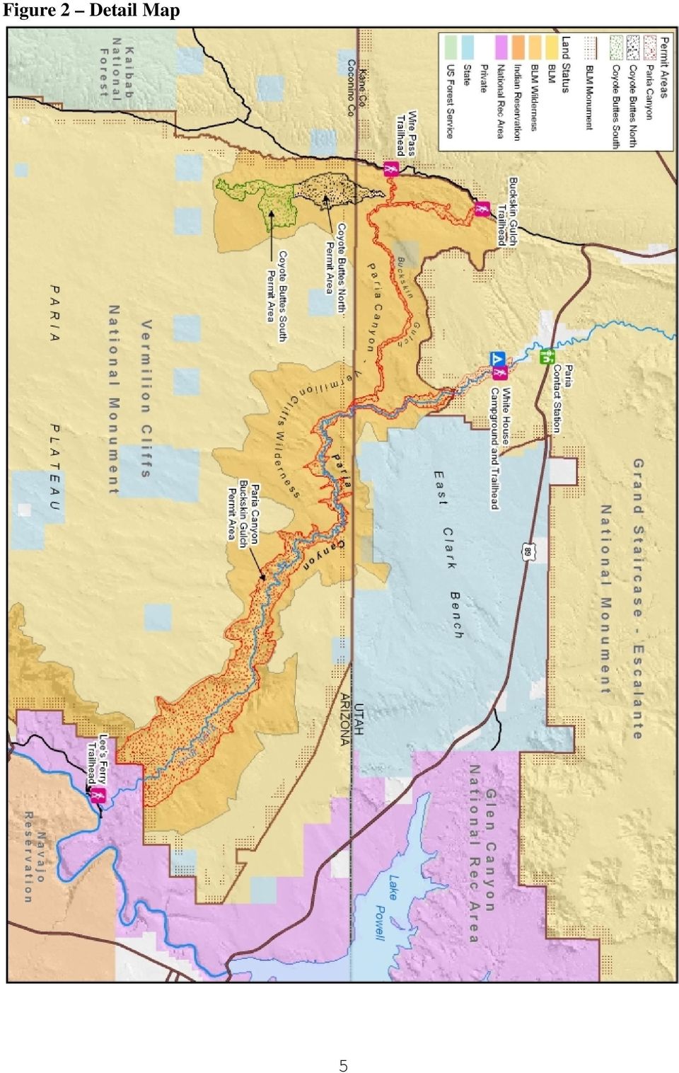
10 Table of Contents A. Reader Letter... 1 B. Introduction to the Paria Canyon/Coyote Buttes Special Management Area... 2 C. Description of the Special Management Area and White House Campground... 2 a. Current Management... 8 b. Commercial Use c. Fee Demonstration History d. Partnerships e. General Management Concerns f. Visitor Description and Visitation g. Current Fee Management D. Proposed Modifications to Recreation Fee Rates E. Operating Costs F. Revenues G. Priorities for Future Expenditures H. Analysis of Recreation Fee Rates I. Fee Collection Process and Permit Delivery System J. Impacts from Changing and Not Changing Recreation Fee Rates K. Public Outreach Figures Figure 1 Regional Map...4 Figure 2 Detail Map 5 Figure 3 Photographs of Paria Canyon, Buckskin Gulch, and Wire Pass 6 Figure 4 Photograph of the Wave within Coyote Buttes North. 7 Figure 5 Photograph of a rock formation within Coyote Buttes South 7 Tables Table 1 Current Permit Types...9 Table 2 Current Visitor Use Allocations.9 Table 3 Special Recreation Permits Issued 12 Table 4 Campground Permits Issued.13 Table 5 SMA Visitors...13 Table 6 Campground Visitors Table 7 Current Fees 14

11 Table 8 Proposed Fee Changes 14 Table 9 SMA Revenue Expended Toward Expenses 16 Table 10 White House Campground Revenue Expended Toward Expenses.17 Table 11 SMA Annual Fee Revenue Collection History...17 Table 12 SMA Projected Annual Fee Revenue..17 Table 13 White House Campground Annual Fee Collection History..18 Table 14 White House Campground Projected Annual Revenue Table 15 SMA Revenues and Expenditures Table 16 Annual Labor Cost...20 Table 17 Annual Operation Cost.21 Table 18 Fee Rates Required to Cover 100% of Costs..22 Table 19 Current Fees Compared to Proposed Fees Table 20 Regional Agency Fee Rates..23 Table 21 Regional Agency Camping Fee Rates.24 Table 22 Advance Online Lottery for Coyote Buttes North.26 Table Hour Lottery for Coyote Buttes North (The Wave).26 Table 24 Advance Online Calendar for Coyote Buttes South..26 Table Hour Online Calendar for Coyote Buttes South..27 Table 26 Advance Online Calendar for Paria Canyon Overnight..27 Table 27 Summary of Existing SMA Permit Process Table 28 Summary of Proposed SMA Permit Process..28 Table 29 Proposed Go Live Dates for Recreation.gov..29 Acronyms AROLPS Arizona Recreation Online Permitting System BLM Bureau of Land Management D/ASIA Dixie/Arizona Strip Interpretive Association FLPMA Federal Land Policy and Management Act FLREA Federal Land Recreation Enhancement Act FY Fiscal Year GCNRA Glen Canyon National Recreation Area GSENM Grand Staircase Escalante National Monument KFO Kanab Field Office NAU Northern Arizona University NPS National Park Service RUP Recreation Use Permit RV Recreational Vehicle SMA Special Management Area ISRP Individual Special Recreation Permit

12 SUU IIC Southern Utah University, Intergovernmental Internship Cooperative VCNM Vermilion Cliffs National Monument

13 A. Reader Letter Dear Reader, Enclosed for your review and comment is the Paria Canyon/Coyote Buttes Special Management Area Draft Business Plan. The Paria Canyon/Coyote Buttes Special Management Area (SMA) is located within the Paria Canyon-Vermilion Cliffs Wilderness and is managed by three Bureau of Land Management (BLM) offices: Arizona Strip Field Office, Kanab Field Office, and Grand Staircase Escalante National Monument. The 20,254 acre SMA is internationally renowned for its scenic beauty, backcountry experiences, and opportunities for solitude. White House Campground is adjacent to the SMA and is generally used as a staging area to access the SMA. It is proposed to adjust non-commercial Individual Special Recreation Permit (ISRP) fees for the SMA and Expanded Amenity Recreation fee for White House Campground. The Federal Land Recreation Enhancement Act, 2004, authorizes the BLM to collect recreational fees when site and areas meet specific criteria as defined that Act. The SMA is divided into three distinct units, both geographically and managerially: Paria Canyon (including Buckskin Gulch and Wire Pass), Coyote Buttes North, and Coyote Buttes South. The proposed permit fee change for Paria Canyon Overnight is from $5 per person per night to $10 per person per night. The existing fee for Wire Pass, Buckskin Gulch, and Paria Canyon Day-Use is $6 per person per day. The proposed fee will decrease to $5 per person per day. The proposed fee change for Coyote Buttes North and South is from $7 and $5 per person per day, respectively, to $12 per person per day for each area. The camping fee at White House Campground is currently set at $5.00 per night per site. The proposed fee change is to increase the camp rate to $10.00 per night per site. It is also proposed that the current online permitting system, Arizona Recreation Online Permit System (AROLPS), transition to a new online permitting system: Recreation.gov. In addition to the fee adjustments outlined above, Recreation.gov would charge a transaction fee for permit applications for Coyote Buttes North, Coyote Buttes South, and Paria Canyon Overnight. For Wire Pass, Buckskin Gulch, Paria Canyon Day-Use, and White House Campground, permits and camping fees would continue to be paid on site. The objective of the Paria Canyon/Coyote Buttes Special Management Area Draft Business Plan is to provide you with the opportunity to review how collected fees have been and are being planned to be used, and give you the opportunity to submit comments on the proposed fee adjustments. Comment may be mailed to Vermilion Cliffs National Monument, Re: Paria Business Plan, 345 E Riverside Dr., St. George, UT 84790; or ed to blm_az_vcnm@blm.gov (put Paria Business Plan comment in the subject line). Comments are due by August 17, Thank you for your interest in public lands. 1

14 B. Introduction to the Paria Canyon/Coyote Buttes Special Management Area The Federal Lands Policy and Management Act (FLPMA) of 1976, also known as the BLM s organic act, originally outlined the agency s roles and responsibilities in the management of public lands including Recreation and Wilderness resources. The Paria Canyon/Coyote Buttes Fee Project was initially managed under Section 315 of the Department of the Interior and Related Agencies Appropriations Act, 1996, commonly known as the Recreation Fee Demonstration Program, and management continued under annual reauthorizations of that legislation. The Paria Canyon/Coyote Buttes was selected as a Fee Demonstration Pilot Project in May 1996, and BLM began collecting fees in May Since 2005, the fee program has been managed under the authority and direction of FLREA. This business plan includes ISRP fees for the SMA and RUP fees for White House Campground. The fee revenues from ISRPs and White House Campground are separated in different accounts and managed accordingly. Vermilion Cliffs National Monument (Arizona) administers the ISRP fees and Kanab Field Office (Utah) the RUP fees. Fees collected at these sites can be used locally, in a more cost efficient manner, for such things as facility repair, maintenance, enhancement, interpretation, visitor information, visitor services, visitor needs assessments, signs, habitat restoration directly related to wildlife-dependent recreation (that is limited to hunting, fishing, wildlife observation, or photography), law enforcement related to public use and recreation, and direct operating or capital costs associated with the Wilderness, Recreation and Visitor Services programs. Three BLM offices assist in the management of the SMA and White House Campground. A Memorandum of Understanding guides the roles and responsibilities of each office. C. Description of the Special Management Area and White House Campground The 20,254-acre Paria Canyon/Coyote Buttes SMA is located on BLM lands in both Arizona and Utah. It is entirely within the 112,190-acre Paria Canyon-Vermilion Cliffs Wilderness Area (designated in 1984) which is also part of the Vermilion Cliffs National Monument (VCNM) in Arizona and the Kanab Field Office (KFO) in Utah. It is bordered by Glen Canyon National Recreation Area (GCNRA) to the east and Grand Staircase-Escalante National Monument (GSENM) and Kaibab National Forest to the west and northwest. The North Rim of the Grand Canyon is due south and other notable recreation destinations such as Zion and Bryce Canyon National Parks are within a few hours drive. It is within the region commonly known as the Grand Circle, which is an international tourism destination, (Figure 1 Regional Map). The SMA and White House Campground are managed by BLM and jointly administered by Arizona Strip Field Office (of which VCNM is a part), within the Arizona Strip District Office; the KFO, which is part of the Color Country District Office; and GSENM. The area lies within the 1st Congressional District in Arizona and the 2nd Congressional District in Utah. The SMA is divided into three distinct units both geographically and managerially: Paria Canyon (including Buckskin Gulch and Wire Pass), Coyote Buttes North, and Coyote Buttes South, (Figure 2 Detailed Map). 2

15 Paria Canyon, Buckskin Gulch, and Wire Pass are widely recognized as one of the longest and most stunning slot canyon combinations in the world. Accessed from four trailheads, these narrow canyons wind their way sinuously downward through seven geologic layers, eventually ending at the Colorado River just below Glen Canyon Dam. The longest route through the entire system is 47 miles and takes the average backpacker four to five days to complete, (Figure 3 Photographs). Coyote Buttes North has become an international destination. The main attraction is The Wave ; an area of lithified, wind-eroded sandstone that is frozen into a whirling mass of stunning color (Figure 4 Photograph). Coyote Buttes South has many geologic features as unique as The Wave; however, the area is less popular than Coyote Buttes North because vehicle access is more difficult. Traveling to Coyote Buttes South requires a four-wheel drive vehicle because of deep sand prevalent throughout the area. Despite the inaccessibility, this area is experiencing a steady increase in popularity (Figure 5 Photograph). The White House Campground, adjacent to White House Trailhead, is located two miles downstream from the Paria Contact Station. Campground amenities include five campsites, picnic tables, two vault toilets, campfire rings, barbeque grills, and BLM recreation and law enforcement patrols. Drinking water and garbage collection are located at the Paria Contact Station at the beginning of the campground access road. White House Campground is mainly used as a staging area for Paria Canyon backpackers. 3

16 Figure 1 Regional Map 4

17 Figure 2 Detail Map 5
18 Figure 3 Photographs of Paria Canyon, Buckskin Gulch, and Wire Pass Photos starting at top left then clockwise: Flood evidence in Buckskin Gulch; two hikers in the Paria Canyon Narrows; a hiker navigates Wire Pass 6

19 Figure 4 Photograph of the Wave within Coyote Buttes North Figure 5 Photograph of a rock formation within Coyote Buttes South 7

20 a. Current Management ISRPs are issued for day hiking, overnight backpacking, as well as permitting dogs in the SMA. RUPs are issued for overnight camping at White House Campground. Several commercial outfitters are permitted for guiding operations in the SMA; however, there is no separate permit allocation for commercial use. As previously stated, the SMA is divided into three distinct geographic units: 1. Paria Canyon (including Buckskin Gulch and Wire Pass) 2. Coyote Buttes North 3. Coyote Buttes South Each of these areas has its own rules. These rules have been written to ensure compliance with the goals defined in the Paria Canyon-Vermilion Cliffs Wilderness Management Plan which include: 1. Provide for the long-term protection and preservation of the area s wilderness character. 2. Manage the area for the use and enjoyment of visitors in a manner that will leave the area unimpaired for future use and enjoyment as wilderness. 3. Manage the area using the minimum tool, equipment, or structure necessary to successfully, safely, and economically accomplish the objective. In order to achieve these goals, the number of people allowed to visit these areas (except for dayuse in Paria Canyon, Buckskin Gulch, and Wire Pass) is limited through a permit system. Permits are distributed in a variety of methods due to various levels of demand for specific areas. These methods include advance online permit and last minute walk-in permits. The maximum group size is ten persons in Paria Canyon, Buckskin Gulch and Wire Pass. This limit applies to both day-use and overnight use. The maximum group size is six persons for Coyote Buttes North and South. Group size restrictions help to preserve solitude and protect wilderness experiences for visitors. Tables 1 and 2 summarize current permit types and visitor use allocations in each of the three areas listed above. 8

21 Table 1. Current Permit Types Type of Use and Payment Method Day Use Self-pay at trailhead Day Use Purchase permit online Day Use Purchase permit through the walk-in lottery Overnight Use Purchase permit online Permit Type Required by Area Paria Canyon, Buckskin Coyote Buttes Gulch and Wire Pass North Coyote Buttes South Yes No No No Yes Yes No Yes Yes Yes Camping not allowed Camping not allowed Table 2. Current Visitor Use Allocations Type of Use and Payment Method Day Use Number of permits issued up to four months in advance Day Use Number of permits issued through a walk-in lottery Day Use Self pay at trailhead Overnight Use Number of permits issued up to four months in advance Total Daily Visitor Use Limits Number of Visitors Permitted per Day Coyote Buttes North Paria Canyon, Buckskin Gulch and Wire Pass Coyote Buttes South N/A N/A Unlimited N/A N/A 20 Camping not allowed Camping not allowed 20 overnight / unlimited day use
22 b. Commercial Use In order to protect natural resources and provide for visitor safety, commercial guiding services are permitted to operate in the SMA. Commercial use is not allocated or managed separately from private use. Visitors and commercial guides compete for available permits on an equal basis. There are two ways for commercial companies to legally obtain permits: 1. Speculatively obtain permits in advance and use them on the authorized date if they were able to sell a trip. While this may appear to be a lucrative option for such a desirable destination, it is rarely employed. Failure to sell a trip would leave the commercial operator with an unused permit, losing their investment of time and money. The guide/s is counted toward the authorized party size. 2. Wait for a visitor who has already obtained a permit to contact the commercial operator. This happens frequently. Visitors obtain permits and often hire an authorized guide. Visitors often lack the needed expertise, equipment, and knowledge of the area to have a safe experience. The addition of a guide/s to a group is not counted as part of the authorized party size. c. Fee Demonstration History Visitor use limits in the SMA were first established in 1986 after completion of the Paria Canyon Vermilion Cliffs Wilderness Management Plan. Visitor use in Paria Canyon, Buckskin Gulch, and Coyote Buttes jumped from 2,400 visits in Fiscal Year (FY) 86 to 10,200 visits in FY96. The dramatic increase in visitation began negatively impacting wilderness resources. One of the biggest issues was visitor health and safety caused by human waste left at the limited number of campsites in the narrow portion of Paria Canyon and Buckskin Gulch. The increase in visitation including large groups also greatly decreased the opportunity for solitude, which detracted from the wilderness experience. In order to effectively manage increasing demand and resource issues, it was determined that a permit system was the optimum solution. A public comment period was part of this process. It was further determined that the Fee Demonstration Program was a viable mechanism to enforce the new limitations and to fund new services associated with managing the area. Planning for the permit system and the development of a Business Plan was initiated in Fee Demonstration Project Chronology May 1996 November 1996 March 1997 May 1997 Site selected as a pilot project Public scoping requesting citizen input on visitor use limits and the introduction of fees Plan of Operation developed AZ Strip Communications Plan implemented 10
23 May 1997 BLM begins collecting fees July 1997 Informational web site launched July 1997 Policy and Procedures Manual drafted September 1997 Business Plan signed January 1998 Implement new visitor use limits February 1999 Current automated permit system launched online d. Partnerships There are four partners which provide information that helps the BLM manage the SMA permit area including: Dixie/Arizona Strip Interpretive Association (D/ASIA); Northern Arizona University (NAU), Glen Canyon National Recreation Area (GCNRA) and the National Weather Service (NWS). Through funding from recreation fees, D/ASIA provides staffing for the Paria Contact Station information desk and the St. George Interagency Visitor Center. These employees answer a wide range of questions and educate visitors how to safely and responsibly visit the area. They also issue permits, compile visitor data, and report emergencies to the proper authorities. D/ASIA and the BLM coordinate to provide pertinent maps, books, hiking gear, souvenirs, and safety items such as sunscreen, hats, and water bottles for sale. D/ASIA also assists the BLM with public events such as Earth Day and National Public Lands Day. Through funding from recreation fees, NAU conducts a recreation site monitoring program in the SMA and surrounding areas. The monitoring is conducted annually by professors and graduate students from the Department of Geography, Planning, and Recreation. Monitoring is conducted to document visitor use, impacts and visitor use patterns. Over time the data is used to identify visitor trends which help the BLM make more informed decisions including determining visitor use allocation levels. The lower portion of Paria Canyon is within GCNRA managed by the National Park Service (NPS). A Memorandum of Understanding was established between BLM and NPS defining fee requirements for this area. Visitors entering GCNRA already pay an entrance fee; therefore, they are not charged for day hiking in lower Paria Canyon. Furthermore, GCNRA allows Paria Canyon overnight backpackers to leave their vehicles in their parking lot at no charge where they are picked up and shuttled north to their desired trailhead. Hikers then conveniently finish at their vehicles in the GCNRA managed parking lot. A Paria Canyon Overnight Permit placed on the dashboard is the only requirement for entrance to the area and parking for the duration of their trip. A partnership with the National Weather Service provides online links to updated weather forecasts, and site specific heat and flash flood advisories. This project is constantly improving with the advancement of technology. 11
24 e. General Management Concerns Visitor safety and resource protection within the designated Wilderness are the two primary management concerns for the SMA. Unfortunately, visitors often come unprepared for a backcountry experience in the SMA. In recent years there have been several visitor injuries and fatalities requiring assistance from county emergency rescue crews. An increasing number of SMA visitors lack the skills and experience to safely navigate an undeveloped wilderness setting. A growing number of visitors are also choosing to hike in extreme or unfavorable weather conditions despite warnings from BLM staff, websites, and signs. The balancing of visitor safety while managing for wilderness values is an ongoing management concern in the SMA. Protecting natural resources and the wilderness character of the SMA is another management concern. Overnight backpackers in Paria Canyon are required to carry out their feces using human waste bags. This policy has greatly improved the sanitary condition of the campsites, especially in the narrow portion of the canyons. The limited number of visitors also protects and contributes to the primitive and unconfined type of recreation experience and protects fragile geologic formations. The BLM s resource and wilderness policies are under constant pressure to yield to increasing visitation demands upon the SMA due to its international popularity and local economic opportunities. f. Visitor Description and Visitation The visitors to the SMA are interested in hiking, backpacking, photography and canyoneering. Backpackers enjoy a remote multi-day adventure in Paria Canyon and its tributaries and day hikers are looking to explore and photograph the unique geologic formations in Coyote Buttes, and take long day hikes in the slot canyons. Visitors come from all 50 states and many foreign countries. The SMA has become an international tourism destination. The area is well known throughout the world and many tourists place a visit to The Wave as their primary destination. The tables 3-6 summarize permits issued and visitation to the SMA since Fiscal Year (FY) Please note ISRPs and RUPs are issued by group and not individually. Most visitors stay one night at White House Campground. The fiscal year for the federal government is from October 1 through September 30. Table 3. Individual Special Recreation Permits Issued SMA Fee Area FY11 FY12 FY13 FY14 Coyote Buttes North 3,005 3,065 2,951 2,976 Coyote Buttes South 1,867 1,990 2,075 2,143 Paria Canyon Overnight 985 1, Paria Canyon Day Use 3,273 3,978 3,976 4,094 Totals 9,130 10,077 9,975 10,157 12
25 Table 4. White House Campground Recreation Use Permits Issued FY11 FY12 FY13 FY Table 5. SMA Visitors SMA Fee Area FY11 FY12 FY13 FY14 Coyote Buttes North 7,128 7,334 7,057 7,132 Coyote Buttes South 4,330 4,655 4,991 5,108 Paria Canyon Overnight 3,420 3,589 3,386 3,503 Paria Canyon Overnight Visitor Days 12,092 12,283 11,446 12,197 Paria Canyon Day Use 7,563 9,142 10,209 9,614 Total Visitors 22,441 24,720 25,643 25,357 Table 6. White House Campground Campground Visitors FY11 FY12 FY13 FY g. Current Fee Management There are four methods by which permits are issued and fees collected for the SMA and White House Campground. The most efficient and heavily used technique for issuing permits and collecting fees is the online permit system, which allows visitors to find an available hiking date and then obtain a hiking/backpacking permit or apply for the online lottery (Coyote Buttes North) from any computer with an internet connection. Walk-in permits are the second-most popular method of obtaining a permit. While these permits could be issued more efficiently online, the walk-in method has proven to be extremely popular for local and state residents as well as national and international visitors. These visitors are often those who have tried unsuccessfully to get an on-line permit as well or spontaneous travelers just passing through the region. Under the walk-in option, permits are issued for next-day hikes. The permit information is manually entered directly into the permit database by staff. This procedure assures data captured from both online and walk-in applications are identical. Under the existing system, fees for walk-in permits are collected at time of sale by BLM staff. The fees are counted according to standard BLM fee collection procedures and deposited into the appropriate recreation fee revenue account. 13
26 BLM employees occasionally accept applications for permits by , fax, and phone. These permit applications are manually entered directly into the permit database by staff. Self-pay envelopes for ISRPs are collected from fee tubes located at White House, Wire Pass, and Buckskin Gulch trailheads. Self-pay envelopes for RUPs at White House Campground are also collected on site. Table 7 illustrates the current fees being charged for the SMA and White House Campground. Table 7. Current Fees Permit Area Existing Fee Coyote Buttes North (online lottery) $5 application fee for online lottery only Coyote Buttes North $7 per person per day Coyote Buttes South $5 per person per day Paria Canyon $5 per person per day Overnight Paria Canyon Day-Use $6 per person per day White House Campground $5 per campsite per night D. Proposed Modifications to Recreation Fee Rates The BLM proposes to raise fees to $12 per person for Coyote Buttes North, $12 dollars per person for Coyote Buttes South, $10 per person per day for Paria Canyon Overnight, and $10 per campsite, per night, at White House Campground. The BLM proposes to decrease the fee for Paria Canyon Day Use (Wire Pass, Buckskin Gulch, Paria Canyon) from $6 per person to $5 per person. The transaction fee to apply for the online Coyote Buttes North Lottery would increase from $5 to $6; however, through Recreation.gov the service fee would only be necessary twice a year instead of every month for frequent applicants. These proposed fee increases should cover operational costs for 5-10 years based on current costs. Table 8 illustrates the proposed changes. Table 8. Proposed Fee Changes Permit Area Proposed Fee Transaction Fee * Coyote Buttes North $12 per person per $6 per application day Coyote Buttes South $12 per person per $6 per application day Paria Canyon $10 per person per $6 per application Overnight day Paria Canyon Day- $5 per person per N/A Use day White House Campground $10 per campsite per night N/A 14
27 *The Recreation.gov transaction fee is the contracted price for Recreation.gov to host the online permitting system and is based on an average costs of the three methods used to apply for a permit: 1) Call center $6.50; 2) Internet $4.50; and 3) In-person $2.00. An average is used in case a large portion of sales are made via the call center. E. Operating Costs Operating costs for managing the SMA and White House Campground fall into several different categories. The various categories include: labor (including law enforcement), facility and trailhead maintenance, supplies, brochures and maps, communication services, vehicles, scientific studies, administrative website and database, and occasionally construction of new recreation facilities such as toilets. Each of these categories is described in further detail below. The most expensive category is labor, which encompasses a variety of tasks related to the SMA. These tasks include: distributing visitor information and issuing permits at three BLM offices, cleaning and maintaining trailhead facilities, conducting field patrols, cleaning up campsites in the Paria River and Buckskin Gulch drainages, collecting fees, data entry, maintaining the BLM website and administering an online permit system. Most of this work is currently done by five BLM employees, two employees from D/ASIA, two summer interns and several volunteers. In 2014, seven volunteers contributed 1,766 hours working maintenance projects and conducting visitor safety patrols. This highly successful volunteer program will continue to be utilized and developed in order to save money and increase the quality of services provided to the public. Due to three visitor fatalities in 2013 and a sharp increase in search and rescue incidences, daily safety patrols were implemented in As a result of the new patrols, labor costs increased by approximately $50,000. In November 2012 the walk-in lottery was moved from the Paria Contact Station to the GSENM Visitor Center in Kanab, Utah. This was done to improve customer service by providing a larger facility that is open all year and more staff to accommodate the growing number of people applying for permits. This decision increased annual labor cost by approximately $40,000. Three additional employees were needed to continue staffing the Paria Contact Station along with conducting the walk-in lottery for Coyote Buttes North and staffing the GSENM Visitor in Kanab during the winter season. Law enforcement, another component of labor, is an important piece of effectively managing the SMA. Besides enforcing BLM regulations and policies, BLM law enforcement rangers conduct search and rescue operations and coordinate with county law enforcement personnel. There is one BLM law enforcement officer assigned to Vermilion Cliffs National Monument. The SMA contributes recreation revenue funding toward this position. Recreation facilities on BLM lands directly supporting the SMA include eight trailheads, one campground, seven vault toilets, a potable water system, and the Paria Contact Station. One seasonal BLM employee and several volunteers maintain these sites on at least a biweekly basis and daily during the busy fall and spring seasons. Besides labor, the costs include buying cleaning supplies, toilet paper, garbage service, water quality testing, toilet pumping and providing a maintenance truck equipped with a pressure washer. Additional vehicles used by 15
28 personnel to conduct field patrols are also supported by recreation fee revenues. In 2011 a double vault toilet was installed at the Wire Pass Trailhead. In 2016 the Paria Contact Station and White House Campground are scheduled for several upgrades. Appropriated deferred maintenance funding has been allocated for the majority of the upgrades for the Paria Contact Station and White House Campground. Annual operating cost also includes a Recreation Impact Monitoring program conducted historically by NAU. Recreation sites within the SMA are checked periodically to ensure the protection of natural resources and to identify potential management issues. Furthermore, Colorado Mesa University is scheduled to conduct an extensive Recreational Experience Baseline Survey for the SMA in Other program costs related to the SMA include buying paper and using BLM copy machines to produce thousands of permits, maps, and brochures annually. Satellite phones, satellite internet, hand held radios, cell phones and a portable radio relay repeater were purchased and are currently used to provide for employee safety, and to provide the most current weather information and emergency services for visitors. Many aspects of program operations for the SMA have been and are supported by appropriated funding. Due to decreases in BLM s annual budget, recreation fee revenues are being used to cover a larger share of the SMA operating cost. It is estimated that annual operating and labor costs for the SMA is $432,000, which is about twice as much as current fee revenue. See Section H, Analysis of Recreation Fee Rates, for an itemized list of estimated labor and operating costs. Tables 9 and 10 below identify how much fee revenue was used to fund operating and labor costs compared to total fee revenue for the past four years. The listed expenditures are only about half of total annual expenditures for the SMA. Annual appropriated funding is not reflected in the tables below. Net losses are shown in parentheses. Table 9. SMA Revenue Expended Toward Expenses Federal Costs Fiscal Staff Labor Operations Funded by Revenues Carryover Year Visitor Fees 2011 $67,903 $88,885 $156,788 $170,738 $13, $60,765 $67,729 $128,494 $183,376 $54, $109,598 $49,249 $158,847 $189,980 $31, $143,452 $101,287 $244,739 $189,312 ($55,427) 16
29 Table 10. White House Campground Revenue Expended Toward Expenses Federal Staff Labor Operations Total Revenues Carryover Fiscal Year Annual Expenditures 2011 $3,211 $1,998 $5,209 $2,893 ($2,316) 2012 $3,030 $2,243 $5,273 $2,762 ($2,511) 2013 $3,497 $2,572 $6,069 $1,675 ($4,394) 2014 $3,309 $3,109 $6,418 $2,112 ($4,306) F. Revenues The maximum number of visitors allowed annually for Coyote Buttes North, Coyote Buttes South, and Paria Canyon Overnight is 7,300 each (365 x 20). Visitation for Coyote Buttes North has long since reached 100% of its 7,300 allocation. Approximately 70% of the visitor allocation for Coyote Buttes South is being used which equals about 5,100 visitors of the 7,300 cap. Paria Canyon Overnight visitation has leveled off at about 3,500 visitors or about 28,000 Recreation Visitor Days (RVDs, one person for 12 hours) annually (average length of stay for backpackers is 4 days). Visitor use in Paria Canyon happens almost entirely in the spring and fall seasons. Visitor use is light during the winter and summer seasons due to unfavorable hiking conditions. Day Use in Paria Canyon, Buckskin Gulch and Wire Pass has increased by approximately 7% annually (average) over the past four years. Approximately 10,500 Paria Canyon Day users are expected in FY 15. Tables 11 and 12 identify the actual revenue collected during the last four years and the projected annual revenue if the proposed fee changes are implemented. Table 11. Permit Area SMA Annual Fee Revenue Collection History SMA Revenue by Permit Area FY11 FY12 FY13 FY 14 Coyote Buttes North $50,204 $51,653 $51,597 $50,806 Coyote Buttes South $22,390 $22,410 $25,670 $25,905 Paria Canyon Overnight $60,461 $61,415 $57,232 $60,983 Paria Canyon Day Use $37,683 $47,898 $55,481 $51,618 Totals $170,738 $183,376 $189,980 $189,312 Table 12. SMA Projected Annual Fee Revenue Permit Area Visitor Days Proposed Fee Rate Total Fees Coyote Buttes North 7,163 $12 per person $85,956 Coyote Buttes South 4,771 $12 per person $57,252 Paria Canyon Overnight 10,425 $10 per person per day $104,250 Paria Canyon Day Use 9,132 $5 per person $45,660 Total 31,491 $293,118 Visitor use at White House Campground has been relatively consistent over the past four years. Most campers are getting ready to begin or returning from a backpacking trip in Paria Canyon. The majority of visitors stay just one night in the campground. Naturally, visitation patterns for White House Campground are very similar to Paria Canyon Overnight. Tables 13 and 14 17
Business Plan. Aravaipa Canyon Wilderness and Special Recreation Management Area
 Wilderness and Special Recreation Management Area Business Plan United States Department of the Interior Bureau of Land Management Business Plan December 2015 Final Aravaipa Canyon Business Plan In Reply
Appendix I: Recreation and Visitor Services Market Analysis for the Kobuk-Seward Peninsula Planning Area
 Appendix I: Recreation and Visitor Services Market Analysis for the Kobuk-Seward Peninsula Planning Area A. Introduction...I-3 B. Salmon Lake/Kigluaik SRMA (Alternatives C and D)...I-4 C. Squirrel River
HIGHLIGHTS EL CENTRO FIELD OFFICE. District Advisory Committee Imperial Sand Dunes Recreation Area Subgroup. December 11, 2014
 HIGHLIGHTS EL CENTRO FIELD OFFICE District Advisory Committee Imperial Sand Dunes Recreation Area Subgroup December 11, 2014 BLM Action: Plank Road Visitor Area Upgrades Status: Preparations are underway
Industry Administration - A Summary of the Draft Concession Contract
 SUMMARY OF CC-DENA001-16 BUSINESS OPPORTUNITY Pre-Solicitation Site Visit, September 3-4, 2014 The (Service) intends to release the Prospectus for Bus Tours, Transit, Shuttle, Food and Beverage, Retail
Troop 476 Reservations Summary
 Document Overview This documents summarizes the reservation process for the high-adventure treks and other treks that Troop 476 goes on. High Adventure or Week Long Summer Camps When To Make Camp Camp
Operating Procedures Manual
 2014 Purpose of this Manual The (OPM) provides an overview of Recreation.gov, with emphasis on business rules and the daily operations of the reservation system. The OPM is primarily for participating
Emergency Response Plan
 ERP 1 Desolation Canyon Kayaking Expedition 2012 Emergency Response Plan (Activate in 12 hours if group has lost expected connection) ERP 2 ERP Table of Contents (For Program Coordinator) 1. A Emergency
Flood Risk Management
 Flood Risk Management Value of Flood Risk Management Every year floods sweep through communities across the United States taking lives, destroying property, shutting down businesses, harming the environment
Flood Risk Management
 Flood Risk Management Value of Flood Risk Management Value to Individuals and Communities Every year floods sweep through communities across the United States taking lives, destroying property, shutting
Strategic Plan 2015-2017. Executive Summary
 Strategic Plan 2015-2017 Executive Summary about westwind Westwind was founded in 1937 by the YWCA of Greater Portland and is now operated by the Westwind Stewardship Group. Founded in 2004, the Westwind
Division of Recreation and Parks. Report: A-1415DEP-006
 Division of Recreation and Parks Office of Inspector General Internal Audit Section Florida Department of Environmental Protection February 19, 2015 3900 Commonwealth Boulevard, MS 40 Tallahassee, Florida
Proposal Brief: The Greater Grand Canyon Heritage National Monument February, 2016. Introduction
 Proposal Brief: The Greater Grand Canyon Heritage National Monument February, 2016 Every 15 or 20 years, it seems, the canyon forces us to undergo a kind of national character exam. If we cannot muster
Land Protection Planning for the National Wildlife Refuge System
 March 2012 Planning Information Brochure 1 Land Protection Planning for the National Wildlife Refuge System The following questions are often asked when the U.S. Fish and Wildlife Service (Service) begins
Transportation Research Needs in National Parks: A Summary and Exploration of Future Trends
 Transportation Research Needs in National Parks: A Summary and Exploration of Future Trends John J. Daigle THIS PAPER BRIEFLY EXPLORES PERTINENT FEDERAL LEGISLATION that has propelled efforts to study
CEDAR CREST CONFERENCE CENTER TWIN LAKES STATE PARK GREEN BAY, VIRGINIA
 CEDAR CREST CONFERENCE CENTER TWIN LAKES STATE PARK GREEN BAY, VIRGINIA WE THINK YOU RE SPECIAL The experienced and caring staff at Cedar Crest Conference Center wants to help you create the perfect event
Planning Your Trip to Mount Rainier National Park!
 Planning Your Trip to Mount Rainier National Park! Grade Level: 5 12+ Overview 100 Learner Objectives: Students will: Recognize how to interpret maps and guidebooks Recognize some interesting places to
Visitor management strategy
 Visitor management strategy Introduction Protected areas attract people. Sometimes the protected area management is glad about people who are interested in their work and activities, sometimes protected
The Colorado College 2012-13 State of the Rockies Project:
 The Colorado College 2012-13 State of the Rockies Project: Water Friendly Futures for the Colorado River Basin Summer Field Work 2012 David Spiegel Oregon Idaho Rockies Field Work 2012 The State of the
How To Understand National Park System
 National Parks Land-Use Facts 388 total units in the system; 84 million acres 2/3 of total acreage in Alaska 20 different types of NPS units (e.g., National Parks, Monuments, Seashore, Battlefields, Historical
Chapter 3 Planning Issues, Opportunities, and Constraints
 Chapter 3 Planning Issues, Opportunities, and Constraints Introduction This chapter describes the key factors planning issues, opportunities, and constraints that influenced development of this RMP/EA.
Floods are too much water on normally dry land. Rivers can flood after heavy rain has fallen over a long period of time. River flooding can last
 Floods are too much water on normally dry land. Rivers can flood after heavy rain has fallen over a long period of time. River flooding can last weeks or longer. River floods usually occur slowly enough
Department of the Interior. Customer Service Plan 2011
 Department of the Interior Customer Service Plan 2011 October 23, 2011 Executive Summary The Department of the Interior (DOI) protects and manages the Nation s natural resources and cultural heritage;
Bridger Teton National Forest Backcountry Tracking SOP with Teton Interagency Dispatch Center
 Bridger Teton National Forest Backcountry Tracking SOP with Teton Interagency Dispatch Center I. PURPOSE: To establish a call-in and call-out procedure (backcountry tracking) for all Forest employees and
WATERSHED COORDINATOR FOR FOURMILE WATERSHED COALITION
 Position Title: Watershed Coordinator Employment Status: Full-time, Salaried Reports To: Four Mile Fire Protection District Board Location: Salina Station Salary Range: $62,000 to $68,000 WATERSHED COORDINATOR
LFA FORESTRY, FIRE, AND STATE LANDS I SSUE BRIEF UTAH STATE LEGISLATURE 2015 GENERAL SESSION. Summary
 UTAH STATE LEGISLATURE 2015 GENERAL SESSION LFA LEGISLATIVE FISCAL ANALYST FORESTRY, FIRE, AND STATE LANDS NATURAL RESOURCES, AGRICULTURE, & ENVIRONMENTAL QUALITY APPROPRIATIONS SUBCOMMITTEE STAFF: IVAN
NEZ PERCE-CLEARWATER FORESTS
 United States Department of Agriculture Forest Service NEZ PERCE-CLEARWATER FORESTS Fish Creek Meadows A Year-Round Playground For Idaho and the Northwest Fish Creek Meadows Year-round Recreation For Everyone
DOMINGUEZ-ESCALANTE NATIONAL CONSERVATION AREA & DOMINGUEZ CANYON WILDERNESS PLANNING NEWSLETTER
 Canyon Clarion DOMINGUEZ-ESCALANTE NATIONAL CONSERVATION AREA & DOMINGUEZ CANYON WILDERNESS PLANNING NEWSLETTER BLM Volume 3, Issue 1 May 2013 www.blm.gov/co/st/en/nca/denca/denca_rmp.html Draft Resource
POLLUTION LIABILITY INSURANCE AGENCY STRATEGIC PLAN 09-11 BIENNIUM
 POLLUTION LIABILITY INSURANCE AGENCY STRATEGIC PLAN 09-11 BIENNIUM Working to improve the economic and environmental health of the State of Washington by providing insurance services to owners and operators
2010 Salida Community Priorities Survey Summary Results
 SURVEY BACKGROUND The 2010 Salida Community Priorities Survey was distributed in September in an effort to obtain feedback about the level of support for various priorities identified in the draft Comprehensive
a GAO-03-470 GAO RECREATION FEES Information on Forest Service Management of Revenue from the Fee Demonstration Program
 GAO United States General Accounting Office Report to the Chairman, Subcommittee on Forests and Forest Health, Committee on Resources, House of Representatives April 2003 RECREATION FEES Information on
MANAGING BY NETWORK COURSE REVIEW - SESSIONS I-IV
 MANAGING BY NETWORK COURSE REVIEW - SESSIONS I-IV NTC Link to Course Materials: http://www.ntc.blm.gov/krc/viewresource.php?courseid=412&programareaid=174 [For an overview of the course view the Course
Town of Snowmass Village. PO Box 5010. Or Delivered To: 1 P a g e
 The Town of Snowmass Village invites qualified consultants to submit a proposal to develop a Request Community for Connectivity Proposals Plan for the Town. Proposals must be submitted by 4:00 pm Friday
Dear Potential Park Host:
 Dear Potential Park Host: I am pleased to hear of your interest in the LCRA Park Host program. Enclosed are applications, background check forms, release from liability forms and an information sheet about
United States Army Corps of Engineers, Civil Works
 United States Army Corps of Engineers, Civil Works Fiscal Year 2013 Federal Program Inventory May 2013 Table of Contents Introduction... 2 Program Inventory... 3 1. Navigation... 3 2. Flood Risk Management...
Revising the Nantahala and Pisgah Land Management Plan Preliminary Need to Change the Existing Land Management Plan
 Revising the Nantahala and Pisgah Land Management Plan Preliminary Need to Change the Existing Land Management Plan Throughout the Plan 1. There is a fundamental need for the revised plan to address how
Economic Impact of The Charleston International Airport Complex
 Economic Impact of The Charleston International Airport Complex Conducted by: Center for Business Research Charleston Metro Chamber of Commerce PO Box 975, Charleston SC 940 January 05 Economic Impact
Maintenance of a Mining Claim or Site
 Maintenance of a Mining Claim or Site Annual Assessment Work County BLM Surface Management Forest Service BLM States Areas of Special Concern Since October 5, 1992 (Public Laws 102-381 and 103-66) only
Agenda. Vision for the Every Kid in a Park Program. Programmatic Facts. Components of the Program. What s Ahead. Questions and Answers Discussion
 Agenda Vision for the Every Kid in a Park Program Programmatic Facts Components of the Program What s Ahead Questions and Answers Discussion Vision Interagency Effort The White House Council on Environmental
p. 1 Our Adventure to Peek-a-boo and Spooky Slot Canyons Written by a city dweller with no backcountry experience
 p. 1 Our Adventure to Peek-a-boo and Spooky Slot Canyons Written by a city dweller with no backcountry experience p. 2 Members of the trip 1. 45 year-old male. Relatively athletic. Play ping-pong; can
WORKING CAPITAL FUND
 WORKING CAPITAL FUND LOCATION: The 17 Western States in Reclamation s Service Area. DESCRIPTION/JUSTIFICATION: The Reclamation Working Capital Fund (WCF) is comprised of various activities designed to
Road Monitoring on BLM Lands 2005-BLM-503. Las Vegas Field Office 2011
 Road Monitoring on BLM Lands 2005-BLM-503 Las Vegas Field Office 2011 BLM Carolyn Ronning, Habitat Conservation Coordinator Las Vegas Field Office 4701 N. Torrey Pines Drive Las Vegas, NV 89130 702-515-5143
United States Department of the Interior
 - - - - -_. --- ----, United States Department of the Interior OFFICE OF INSPECTOR GENERAL Washington, DC 20240 JAN 1 8 2008 The Honorable George Miller Chairman, Committee on Education and Labor House
TYPES OF ACCOMMODATION
 TYPES OF ACCOMMODATION a) A hotel www.bellavistalignano.it/img/sl/hotel/hotel-b. A hotel is an establishment providing paid accommodation. Hotels used to offer basic accommodation in the past, but nowadays
Arapaho & Roosevelt National Forests 2013 Flood: Long-term Recovery in a Changed Landscape
 Arapaho & Roosevelt National Forests 2013 Flood: Long-term Recovery in a Changed Landscape Spring 2014 The flood of September 2013 changed the landscape of the Boulder and Canyon Lakes Ranger Districts.
First Annual Centennial Strategy for. Yucca House National Monument
 First Annual Centennial Strategy for Yucca House National Monument August 2007 Year: 2007 Vision Statement Yucca House National Monument was set aside in 1919 to preserve an unexcavated Ancestral Puebloan
Please note that before your reservation date is confirmed the Group User Agreement and $250 deposit must be received by our office.
 4232 Highway 11 Marietta, SC 29661 Office Phone 864-660-1065 www.pleasantridgecampandretreatcenter.org Thank you for your interest in Pleasant Ridge Camp and Retreat Center. This packet contains a group
Impact of Tourism in the Local Economy of Sauraha 1
 Impact of Tourism in the Local Economy of Sauraha 1 - Prabin Dongol pravindongol@msn.com This study explores the aspects of Chitwan as a tourist destination. The discussion is based on a field work in
Many Voices, Many Visions: Analyzing Contemporary Environmental Issues. Teacher s Masters California Education and the Environment Initiative
 11 Teacher s Masters California Education and the Environment Initiative U.S. History History-Social Science Standard 11.11.5. Many Voices, Many Visions: Analyzing Contemporary Environmental Issues California
ZION NATIONAL PARK ITINERARY
 ZION NATIONAL PARK ITINERARY Day 1 Travel / Arrive / Check-in Lodging, Afternoon walk, dining, relax. There s so much natural beauty waiting to be discovered at Zion National Park, so check in to your
Automated Fee Machine Functional Requirements to address in a park RFP
 This document is a guide for the basic functional requirements that a Park might include when considering procurement of an Automated Fee machine. Introduction Automated Fee Machines (AFMs) are stand-alone
6 Wilderness Preservation and Management
 6 Wilderness Preservation and Management All NPS lands will be evaluated for their eligibility for inclusion within the national wilderness preservation system. For those lands that possess wilderness
APPENDIX B: TRAIL DEVELOPMENT AND MANAGEMENT STANDARDS
 APPENDIX B: TRAIL DEVELOPMENT AND MANAGEMENT STANDARDS This section provides guidance on a variety of trail issues for planners and developers of the Ice Age NST across the state. It also provides introductory
OUTREACH NOTICE Reply to outreach by October 17, 2014
 Wildlife INTERN, GS-0499-04 Kaibab National Forest, South Zone Williams, AZ Caring for the Land and Serving People OUTREACH NOTICE Reply to outreach by October 17, 2014 IF YOU RE LOOKING FOR A CHALLENGING
UPPER COLUMBIA BASIN NETWORK VEGETATION CLASSIFICATION AND MAPPING PROGRAM
 UPPER COLUMBIA BASIN NETWORK VEGETATION CLASSIFICATION AND MAPPING PROGRAM The Upper Columbia Basin Network (UCBN) includes nine parks with significant natural resources in the states of Idaho, Montana,
National Interagency Aviation Council (NIAC) Phase III Strategy
 Phase III Strategy") National Interagency Aviation Council (NIAC) Phase III Strategy I am happy to be here today. Aviation remains a key component to wildland fire management. The future for the agencies will undoubtedly involve
National Interagency Aviation Council (NIAC) Phase III Strategy I am happy to be here today. Aviation remains a key component to wildland fire management. The future for the agencies will undoubtedly involve
STEAMBOAT LAKE WATER AND SANITATION DISTRICT PETITION FOR AMENDMENT TO SERVICE PLAN TABLE OF CONTENTS. SECTION DESCRIPTION Page
 STEAMBOAT LAKE WATER AND SANITATION DISTRICT PETITION FOR AMENDMENT TO SERVICE PLAN TABLE OF CONTENTS SECTION DESCRIPTION Page 1 Executive Summary / Brief History 2 2 Services Provided / Administration
2015 BEAR HUNTING REGULATIONS
 2015 BEAR HUNTING REGULATIONS Please read the following regulations carefully. In addition, general hunting regulations, legal firearms, and bows and arrows allowed for big game hunting are described in
Backcountry Avalanche Rescue Reference
 1 Backcountry Avalanche Rescue Reference This document is part of Decision Making in Avalanche Terrain: a fieldbook for winter backcountry users by Pascal Haegeli, Roger Atkins and Karl Klassen and provides
TABLE OF CONTENTS. INTRODUCTION...1 Purpose of a Comprehensive Plan...1 McKenzie County Comprehensive Plan...1 Definitions...2 Goal...2 Vision...
 MCKENZIE COUNTY COMPREHENSIVE PLAN TABLE OF CONTENTS INTRODUCTION...1 Purpose of a Comprehensive Plan...1 McKenzie County Comprehensive Plan...1 Definitions...2 Goal....2 Vision...3 ECONOMIC DEVELOPMENT...4
For Historically Designated Homes & Buildings
 Ninth Street Historic Park Acknowledgements This project was paid for in part by a State Historical Fund grant from the Colorado Historical Society. The contents contained herein do not necessarily reflect
Kenya Wildlife Service
 Kenya Wildlife Service Pricing of Park Tourist Recreation James Njogu April 2011 ABOUT US OUR VISION To be a world leader in wildlife conservation OUR MISSION To sustainably conserve and manage Kenya s
We will send you additional information to complete and send back. PARTICIPANTS MUST RESERVE THEIR ROOMS BY WEDNESDAY MAY 16 TH, 2013.
 MGM RESORTS INTERNATIONAL HOSPITALITY INTERNSHIP PROGRAM COLLEGE PROGRAMS HOUSING TALENT ACQUISITION 4886 Frank Sinatra Drive, Las Vegas, NV 89158 collegerelations@mgmresorts.com Participants of the Hospitality
Controlled Hunts, Special Hunts, Tags and Permits
 Controlled Hunts, Special Hunts, Tags and Permits Controlled Hunts, Special Hunts, Tags and Permits What is a Controlled Hunt? It is a hunt with a limited number of tags in a specific area for a specific
RHODE ISLAND DEPARTMENT OF ENVIRONMENTAL MANAGEMENT FY 2002-2003 WORK PLAN - OFFICE OF MANAGEMENT SERVICES
 RHODE ISLAND DEPARTMENT OF ENVIRONMENTAL MANAGEMENT FY 2002-2003 WORK PLAN - OFFICE OF MANAGEMENT SERVICES I. Program Name and Description: The was created and expanded in 1996 by executive order of the
WHY WE CREATED THIS SELF-ASSESSMENT CHECK-LIST
 Tourism and Deserts A practical guide to managing the social and environmental impacts WHY WE CREATED THIS SELF-ASSESSMENT CHECK-LIST This self-assessment check-list is designed to help you assess both
vision 2015 FIVE YEAR STRATEGIC PLAN PINELLAS COUNTY TAX COLLECTOR
 FIVE YEAR STRATEGIC PLAN PINELLAS COUNTY TAX COLLECTOR Prepared by: Barbara Hastings, Organization Management Analyst Chad McLeod, Manager of Public Affairs and Compliance Revised 041113 Table of Contents
JOSEPH H. MAROON. Over 30 years in senior leadership positions with premier legislative, executive branch and private conservation organizations.
 JOSEPH H. MAROON EXPERIENCE SUMMARY Over 30 years in senior leadership positions with premier legislative, executive branch and private conservation organizations. Recipient of several awards for outstanding
1 of 7 3/10/2013 12:40 AM
 1 of 7 3/10/2013 12:40 AM Find a Business About Kanab Business Resources Join the Chamber Contact Us For Members Search Search Site Chamber News 12/19/12 Small Business Job Creation Kanab, Utah Chamber
Key programs and relevant studies
 ALASKA DEPARTMENT OF NATURAL RESOURCES Key programs and relevant studies The Alaska Department of Natural Resources manages Alaska's surface and subsurface resources, except for fish and game. This includes
1620 L Street, NW 1620 L Street, NW
 Subject: Analysis Report on the results of a Bureau of Land Management data call for information on NEPA records for geophysical exploration of oil, gas, or geothermal energy. Date: 1/4/2006 Analyst: Mel
DEPARTMENT OF ENVIRONMENTAL QUALITY Environmental Assessment
 DEPARTMENT OF ENVIRONMENTAL QUALITY Environmental Assessment Water Protection Bureau Name of Project: Applicant: Ueland Land Development LLC Type of Project: Proposed discharge of treated domestic wastewater
About Fact Sheets Contact Us Partners Products Site Map FAQ Help
 About Fact Sheets Contact Us Partners Products Site Map FAQ Help Home Articles PLSS Article The Public Land Survey System (PLSS) What is the PLSS? History Commonly Used Terms Related Links What is the
Public Survey for Phase I
 Rockfish Valley Area Plan: Public Survey for Phase I For Nelson County Residents & Property Owners Name: OPTIONAL: Location of residence or property: o Address: o Voting District: North Central West South
FINANCE. Annual Fiscal Plan. Original. Actual
 FINANCE Description The Director of Finance is charged by State law with all duties mandated for the constitutional offices of the Treasurer and Commissioner of Revenue as prescribed by the Code of Virginia
MEMORANDUM OF UNDERSTANDING
 MEMORANDUM OF UNDERSTANDING DEPARTMENT OF HEALTH AND HUMAN SERVICES Centers for Disease Control and Prevention Indian Health Service Office of Public Health and Science And DEPARTMENT OF AGRICULTURE Food
Offshore development benefits. www.shell.us/alaska
 8 C H A P T E R E i g h t: Offshore development benefits www.shell.us/alaska Barrow, Alaska The Ripples of Offshore Development Benefits Energy production has done much for Alaskans previously, and by
Table of Contents ESF-3-1 034-00-13
 Table of Contents Primary Coordinating Agency... 2 Local Supporting Agencies... 2 State, Regional, and Federal Agencies and Organizations... 3 Purpose... 3 Situations and Assumptions... 4 Direction and
Emergency Operations Plan ANNEX K - UTILITIES RESTORATION ESF #3, #12 I. MNWALK REQUIREMENTS. Item #: 1, 4, 46, 53, 54
 ANNEX K - UTILITIES RESTORATION ESF #3, #12 I. MNWALK REQUIREMENTS Item #: 1, 4, 46, 53, 54 II. PURPOSE The purpose of this annex is to describe the organization, operational concepts and responsibilities
UK hiking tourism. CH - Visitnorway.com
 UK hiking tourism CH - Visitnorway.com Contents 1. Executive Summary 3 2. Introduction 4 3. Research on the Internet: Phase 1 5 3.01: Tour operators: 5 3.02: Websites/forums: 5 3.03: Hiking/Outdoor magazines
River Management 2013 Colorado Flood
 River Management 2013 Colorado Flood Damages, Countermeasures, Socio-Economic Impacts Miles Blair, Allen Chestnut, Hwayoung Kim, & Caroline Ubing CIVE 717 Spring 2014 Flood Statistics Sept 9 th 16 th,
How to Boost Arizona s Economy & Protect Ourselves Against Rising Energy Costs: A SWEEP Guide to Energy Efficiency and Decoupling
 How to Boost Arizona s Economy & Protect Ourselves Against Rising Energy Costs: A SWEEP Guide to Energy Efficiency and Decoupling What s the problem? Arizona s gas and electricity costs keep rising. Every
Environmental Fund for Arizona Educational Activities Menu
 FOCUS: WILDLIFE REHABILITATION & EDUCATION Environmental Fund for Arizona Educational Activities Menu Audubon Arizona Members of Audubon Arizona s staff offer presentations on a variety of topics related
Catalina State Park 11570 N Oracle Road Tucson, AZ 85737. Dear Couple: Thank you for considering Catalina as the location for your wedding.
 Catalina State Park 11570 N Oracle Road Tucson, AZ 85737 Dear Couple: Thank you for considering Catalina as the location for your wedding. The enclosed material will help you decide if an Arizona State
Utah Recruitment Initiative
 ID: 08-W-16UT Governor s Office of Economic Development The Governor's Office of Economic Development (GOED) charter is based on Governor Jon Huntsman's commitment to economic development statewide. The
Economic Development Element
 The Strawberry Ladies by Tara Stood Economic Development Element Economic development enhances San Clemente s quality of life by providing local goods and services and expanding employment and business
BI-POLE III - KEEWATINOOW CONVERTER STATION PROJECT Construction Access Management Plan
 2013 BI-POLE III - KEEWATINOOW CONVERTER STATION PROJECT Construction Access Management Plan Manitoba Hydro Manitoba Hydro 9/9/2013 BI-POLE III KEEWATINOOW CONVERTER STATION PROJECT Construction Access
Horse Lover s Management Corporation Reach 11 Recreation Area Arizona Horse Lover s Park Facility Use Agreement
 THIS AGREEMENT made and entered into this day of, 20, by and between HORSE LOVER S MANAGEMENT CORPORATION hereinafter called HLMC and hereinafter called User. The Equestrian Program Coordinator, hereinafter
BACKGROUNDER. Parks and Recreation in the United States. The National Park System. Margaret Walls. January 2009
 January 2009 BACKGROUNDER Parks and Recreation in the United States The Park System Margaret 1616 P St. NW Washington, DC 20036 202-328-5000 www.rff.org Parks and Recreation in the United States: The Park
North Carolina s Blue Ridge Mountain Host
 North Carolina s Blue Ridge Mountain Host Dear Blue Ridge Mountain area business: Tourism affects every business in Western North Carolina. Annually, visitors spend more than $1 billion in the Blue Ridge
ARIZONA GAME AND FISH DEPARTMENT HABITAT PARTNERSHIP PROGRAM HABITAT ENHANCEMENT AND WILDLIFE MANAGEMENT PROPOSAL PROJECT INFORMATION
 ARIZONA GAME AND FISH DEPARTMENT HABITAT PARTNERSHIP PROGRAM HABITAT ENHANCEMENT AND WILDLIFE MANAGEMENT PROPOSAL Project Title: Houston Mesa, Tank Maintenance: PROJECT INFORMATION Project Type: Tank cleanout,
Horseshoe Ranch Management Planning Process
 Horseshoe Ranch Management Planning Process Community-Based Process and Results Prepared By: Region VI 2 Table of Contents Announcement... 3 Background... 4 Description planning area... 5 Scoping... 6
MOBILE FOR RECREATION ORGANIZATIONS: WHY IT S TIME FOR A STRATEGY
 MOBILE FOR RECREATION ORGANIZATIONS: WHY IT S TIME FOR A STRATEGY Introduction In 2011, the number of smartphones sold exceeded the number of PCs sold. It s time for organizations to pay attention. People
Emergency Management is responsible for coordinating the City of Houston s preparation for and response to emergency situations.
 CITY OF HOUSTON Office of Emergency Management October 2004 Emergency Management is responsible for coordinating the City of Houston s preparation for and response to emergency situations. Houston is exposed
W p m. Parent Manual& Map. a C ea
 N R A E L Ca GR O 2015 LORE EXP l i W dcat W p m PLAY COVER DIS Parent Manual& Map s u p n o m i t a C ea Recr SO WHAT S THIS CAMP ALL ABOUT? COUNSELORS: Our staff is made up primarily of college students
MAQUINNA PROVINCIAL PARK
 MAQUINNA PROVINCIAL PARK PURPOSE STATEMENT AND ZONING PLAN February 2003 MAQUINNA PROVINCIAL PARK Purpose Statement and Zoning Plan Primary Role The primary role of Maquinna Provincial Park is to protect
Girl Scout Workshops Registration Packet
 Registration Packet How to Book To make a reservation download the Girl Scout Workshop Request Form. Submit a completed copy by fax (510) 729-7324 or by email at least 6 weeks in advance. We are unable
10. Bureau of Information Technology
 10. Bureau of Information Technology Act 6634 (a) There is established within the Office of the Governor, a Bureau of Information Technology (BIT). The Bureau shall be administered by a Director, who shall
Capitol Reef National Park. Burr Trail Modifications Final Environmental Impact Statement/ Assessment of Effect. December 2005.
 National Park Service U.S. Department of the Interior Burr Trail Modifications Final Environmental Impact Statement/ Assessment of Effect December 2005 Capitol Reef National Park Utah Final Environmental
SEE THE USA FOR $50 A DAY
 Travel Cheap (Rev 3) Karl Belser 17 October 2002 5544 Drysdale Drive (1415 words) San Jose, CA 95124 408-723-0315 SEE THE USA FOR $50 A DAY By Karl Arnold Belser Do you like to travel, have limited money,
Proposal to the Trinity Adaptive Management Working Group (TAMWG)
") Proposal to the Trinity Adaptive Management Working Group (TAMWG) Request that the TAMWG recommend that the Trinity River Restoration Program fund BLM to purchase the Weigel parcel at Gold Bar (river mile
Proposal to the Trinity Adaptive Management Working Group (TAMWG) Request that the TAMWG recommend that the Trinity River Restoration Program fund BLM to purchase the Weigel parcel at Gold Bar (river mile