Nautische bodem en toegankelijkheid in Zeebrugge en andere havens
|
|
|
- Asher Antony Paul
- 8 years ago
- Views:
Transcription
1 Nautische bodem en toegankelijkheid in Zeebrugge en andere havens Studiedag Zee en waterbouw in en rond Vlaanderen IE NET 4 juni 2015, Antwerpen Thomas Van Hoestenberghe (Fluves) Joris Vanlede (Waterbouwkundig Laboratorium) Topics 1. Concept nautical bottom 2. Case Zeebrugge 3. European harbours 4. Case Cochin, India 1

2 1. Concept nautical bottom 1. Concept nautical bottom The level where physicalcharacteristicsof characteristics the bottom reach a critical limit beyond which contact with a ship s keel causes either damage or unacceptable effects on controllability and manoeuvrability PIANC IAPH (1997) confirmed by PIANC WG49 (2014)? 2

3 Nautical History Practical Criterium Practical Measurement Strategy Echosounder Density Rheology (?) Nautical History Physical characteristics of mud Zeebrugge, 1986 Rigidity Density 210 khz Rheological transition Depth 33 khz 3

4 Nautical History Practical Measurement Strategy Rheological transition & Corresponding Density Choice of Critical Density Zeebrugge 1.15 t/m³ (tot 2004) Rotterdam 1.20 t/m³ Nantes St Nazaire, Bordeaux 1.20 t/m³ Cayenne 1.27 t/m³ Germany t/m³ Rheology density relation needs to be checked regularly Density Measurements 4

5 Nautical check of 1997 Rigidity Rheological transition 1 Rheological transition Rheological transition 2 Depth Nautical check of 1997) Observations since 1996 Thickness mud layer: 2 to 4m 1,15 t/m³ horizon difficult to control Fine sediment (low sand fraction) Change in rheology depth relation 2 rheological transitions Level 1: t/m3 Level 2: t/m3 Change criterion of nautical bottom? 1,15 t/m³ >?? 5

6 Update Nautical Bottom ( ) captive manoeuvring tests 3 ship models 80 different mud water combinations water t section Tes mud Test section Delefortrie et al (2005) J. Mar. Sci. Technol. Update Nautical Bottom ( ) e to interface (%) Under keel clearanc captive manoeuvring tests d c b f Density (t/m³) h g e S Mathematical Model of Simulator Real time simulation study 6
 e to interface (%) Under keel clearanc 35 30 25 20 15 10 5 0-5 -10-15")
7 Update Nautical Bottom ( ) Result: dual criterium (1,2 density khz) Top mud = 210kHz (-12,5) Top mud -7% (-13,5 LAT) NB +10% (-14,1 LAT) NB = 1,2T/m³ (-15,5 LAT) Restrictions in harbour: mud layer Top of mud (cohesive sediment): echosounder => 210 khz (density +/- 1,05 T/m³) Fluid mud Consolidated mud Nautical bottom level Hard bottom (cohesive sediment) : echosounder => 33 khz (density 1.35 T/m³) 7
 : echosounder => 33 khz (density")
8 Nautical Bottom: Active Research Micro Macro 2. Case Zeebrugge 8

9 LT analysis of the behaviour of mud in Zeebrugge Different reference levels Analysis dredging gworks Research Goal: Identify Influencing Factors Evolution Reference Levels Seasonality in top of the mud layer Influencing Factors Influence on: Top of the mud layer (210 khz) Dredging works Volume balance Influence of: Seasons Tides (Spring/Neap & Intratidal) Fresh water inflow Wind Waves in the North Sea Surge in the North Sea Sediment Concentration in the NS 9
 Fresh water inflow Wind Waves in the North Sea Surge in the North Sea Sediment Concentration in the")
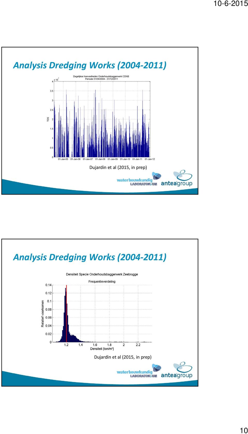
10 Analysis Dredging Works ( ) Dujardin et al (2015, in prep) Analysis Dredging Works ( ) Dujardin et al (2015, in prep) 10
11 Evolution Reference Levels Dujardin et al (2015, in prep) Soundings CDNB khz Max Std Std Min 1,15 kg/dm³ Dujardin et al (2015, in prep) 22 11
")
12 Soundings CDNB khz 115kg/dm³ 1,15 Dujardin et al (2015, in prep) 23 Soundings CDNB khz 1,20 kg/dm³ 33 khz Dujardin et al (2015, in prep) 24 12

13 Soundings CDNB khz 1,20 kg/dm³ 33 khz Dujardin et al (2015, in prep) 25 Spring/Neap variation sedimentation Bron Siltation NT [TDS/day] Siltation ST [TDS/day] Ratio Sprin/Neap Average Siltation [TDS/day] Lanckneus & Van Lancker (2001) , Claeys et al. (2001) Dujardin et al. (2009) IMDC (2011) , Average ,
![Siltation [TDS/day] Lanckneus & Van Lancker (2001) 5041 12820 2,5 8931 Claeys et al.](/docs-images/50/15467809/images/page_13.jpg "(2001) 1590 6400 4 3995 Dujardin et al.")
14 Seasonality in top of the mud layer Detailed measurements

15 Top sediment: variation summer/winter CDNB zone VH zone Max Sediment accumulation zone Temporal variation top sediment 5 november: spring tide top mud layer: + 1to 2 m in whole harbour 6 november: 1 m by consolidation 15

16 Consolidation AII February April 2013 Little dredging 1 2 m consolidation top sediment But 1.2 increase Consolidation Consolidation of 1 m per day In 2 weeks: g /cm³ Similar to results consolidation tests FHR 1,13 1,16 ZBR: 1 m/day 16

17 Density flow Fluid mud moved by gravity from CDNB to AII dock zone AII dock zone CDNB zone Slope 0.23 CDNB functioning as sediment trap Areaof sedimentation depends on season: Winter: full filling of the harbour Events february, november, december 2013 y,, thick light layers (< 1.15 T/m³) in AII/VH Summer: first filling CDNB + density currents events juin, september more dense layers (> 1.15 T/m³) in AII/VH Density flow: when slope > certain treshold? 17
 in AII/VH Summer: first filling CDNB + density currents events juin, september more dense layers (> 1.")
18 Influence factors on sediment volume in ZBR SPM concentration outside harbour SPM transport towards harbor Sedimentprocessesinharbour in harbour, function of: Moment in tide, meteorology, spring neap, season Consolidation Density flow Dredging works, ship movement 3. European harbours 18

19 North Sea Emden (EM) Ijmuiden Ijmuiden (IJ) Rotterdam (RO) Zeebrugge (ZB) Deurganckdok (DG) EM IJ RO DG ZB? Initial density of 1.1 g/cm3 Initial mud level in the columns: 275 cm 19

20 4. Case Cochin, India Cochin 20

21 Project methodology Objective Increase nautical accessibility to/in Port UKC 210 khz: +10%? Method Study siltation processes Define remediating actions Actions Collect data Run models & analyze scenario s Estimate nautical depth parameters HYDRODYNAMIC MODELLING DSS OPTIMISE DREDGING DUMPPING PROCESS FIELD DATA SCHEMATISE SILTATION PROCESS BATHY GEOTECHNICAL WAVE CURRENT. SILTATION ARRESTING METHODS NAUTICAL MODEL NAUTICAL DEPTH ESTIMATE SILTATION QUANTITY ACCEPTABLE PARAMETERS 21
22 Field data Wave, tide Velocity, discharge Meteo SPM, salinity Bed sediments Nautical model Flanders Hydraulics Research & Ghent University # mud viscosity, density, thicknesses, UKC acceptable? Analysis: objective + expert judgment by Cochin/ Belgian Pilots nautical depth Towing Tank for Manoeuvres in Shallow and Confined Water Full Mission Bridge Simulators 22
23 The Stijn Claeys, Charlotte Cleen, Bart Deckers, Guillaume Delefortrie, Katrien Eloot, Maarten Jacobs, Tomas Van Oyen, Joris Group: Meshkati Shahmirzadi, Arvid Dujardin, Marcelo Heredia, Renaat De Peter Thomas Van Hoestenberghe Acknowledgement Maritime Access Division (Dept Mobility & Public Works) Finances research on influencing factors siltation ZB g Important partner in current research activities on nautical bottom 23
Nautical Bottom How to keep mud under control
 Nautical Bottom How to keep mud under control Seminário Internacional em Portos e Hidrovias Rio de Janeiro 11 sep 2014 Joris Vanlede Flanders Hydraulics Research joris.vanlede@mow.vlaanderen.be Zeebrugge
Silt (Sludge) Test Tank: A platform for nautical bottom rheology research to optimize in-situ measurement tools and reduce dredging activities
 Test Tank: A platform for nautical bottom rheology research to optimize in-situ measurement tools and reduce dredging activities") Silt (Sludge) Test Tank: A platform for nautical bottom rheology research to optimize in-situ measurement tools and reduce dredging activities Stijn Claeys, Thomas Van Hoestenberghe, Jan De Schutter, Frank
Silt (Sludge) Test Tank: A platform for nautical bottom rheology research to optimize in-situ measurement tools and reduce dredging activities Stijn Claeys, Thomas Van Hoestenberghe, Jan De Schutter, Frank
The Rheocable Method:
 The Rheocable Method: Determining Nautical Depth in the Presence of Fluid Mud. Marc Druyts 1, Peteralv Brabres 2 and Jason Errey 3 The nautical depth is defined as the transition zone between the fluid
CFD Modelling of a Physical Scale Model: assessing model skill. Kristof Verelst 28-11-2014 FHR, Antwerp
 CFD Modelling of a Physical Scale Model: assessing model skill Kristof Verelst 28-11-2014 FHR, Antwerp Introduction Introduction WL_13_61 CFD simulations of hydrodynamics for hydraulic structures (00_085)
THE NAUTICAL BOTTOM CONCEPT IN THE HARBOUR OF ZEEBRUGGE
 THE NAUTICAL BOTTOM CONCEPT IN THE HARBOUR OF ZEEBRUGGE Guillaume Delefortrie, Ghent University, Belgium, Guillaume.Delefortrie@UGent.be Marc Vantorre, Ghent University, Belgium, Marc.Vantorre@UGent.be
Departement Mobiliteit en Openbare Werken Maritieme Toegang
 What happens the day after we stop dredging? Why is dredging necessary for navigation and trade? Ir. Freddy Aerts Flemish Government, Mobility and Public Works Department, Maritime Access Division, Belgium
VLAAMSE OVERHEID DEPARTEMENT MOBILITEIT EN OPENBARE WERKEN
 VLAAMSE OVERHEID DEPARTEMENT MOBILITEIT EN OPENBARE WERKEN WATERBOUWKUNDIG LABORATORIUM Langdurige monitoring van zout/zoet-verdeling in de haven van Zeebrugge en monitoring van zoutconcentratie, slibconcentratie
Approach Channels A Guide for Design. Progress of MarCom Working Group 49 Dr Mark McBride HR Wallingford Ltd
 Approach Channels A Guide for Design Progress of MarCom Working Group 49 Dr Mark McBride HR Wallingford Ltd Brief history PIANC guidance on channel design 1972 - Working Group 2 of the PIANC International
Approach Channels A Guide for Design. Progress of MarCom Working Group 49/121 Dr Mark McBride HR Wallingford Ltd
 Approach Channels A Guide for Design Progress of MarCom Working Group 49/121 Dr Mark McBride HR Wallingford Ltd PIANC guidance on channel design Brief history 1972 - Working Group 2 of the PIANC International
Passenger Terminal Amsterdam
 Fact sheet large cruise ships to Passenger Terminal Amsterdam Port of Amsterdam Amsterdam-IJmond Pilot Organization 2009 Version: November 6 th 2009 This fact sheet provides information on the passage
Planning & Control Maintenance Dredging in the. Head of the Dredging Division Port of Rotterdam
 Planning & Control Maintenance Dredging in the Port of frotterdam Arie Noordijk Head of the Dredging Division Port of Rotterdam 1 Contents of this presentation Overview Port of Rotterdam (numbers) Sedimentation
Choices and Applications of 2D/3D models for supporting harbour & coastal management
 Choices and Applications of 2D/3D models for supporting harbour & coastal management Terug naar overzicht Rob Uittenbogaard (1,2) (1) WL Delft Hydraulics (2) Delft University of Technology ; J.M. Burgerscentre
Benefits of Navigational Port Studies
 Navigational Services within Port Development Hvad er udfordringerne? - Kampen om vand og land - Kan man bringe større skibe ind i eksisterende havne og derved øge godsmængden? - Vil et krav om at flytte
Regulation for the upstream and downstream navigation of 8,000 and more TEU container vessels to the port of Antwerp with a maximum draught of 145 dm
 Regulation for the upstream and downstream navigation of 8,000 and more TEU container vessels to the port of Antwerp with a maximum draught of 145 dm 1. In general In order to gain an insight into the
INSTALLATION and LOGISTICS of OFFSHORE WIND FARMS
 POWER Offshore Summer School 2006 INSTALLATION and LOGISTICS of OFFSHORE WIND FARMS Gerard van Bussel The Netherlands Offshore transport and installation vessels Semi Submersible Sheer leg crane Ship type
Contents. 1. PROFILE p2. 2. SERVICES 2.1 Offshore Support Services p 4 Offshore support p 6 ROV operations p 8
 OCTOBER 2013 22 Contents 1. PROFILE p2 2. SERVICES 2.1 Offshore Support Services p 4 Offshore support p 6 ROV operations p 8 2.2 Hydrographic & Geophysical services p 10 Bathymetric surveys p 12 High resolution
The concepts developed in this standard include the following: Oceans cover about 70% of the surface of the Earth.
 Name Date Grade 5 SOL 5.6 Review Oceans Made by SOLpass - www.solpass.org solpass100@comcast.net Reproduction is permitted for SOLpass subscribers only. The concepts developed in this standard include
XI / PHYSICS FLUIDS IN MOTION 11/PA
 Viscosity It is the property of a liquid due to which it flows in the form of layers and each layer opposes the motion of its adjacent layer. Cause of viscosity Consider two neighboring liquid layers A
SAFE WATERWAYS. Part 1(a) GUIDELINES FOR THE SAFE DESIGN OF COMMERCIAL SHIPPING CHANNELS (A USERS GUIDE TO THE DESIGN, MAINTENANCE ...
 GUIDELINES FOR THE SAFE DESIGN OF COMMERCIAL SHIPPING CHANNELS (A USERS GUIDE TO THE DESIGN, MAINTENANCE ...") SAFE WATERWAYS (A USERS GUIDE TO THE DESIGN, MAINTENANCE AND SAFE USE OF WATERWAYS) Part 1(a) GUIDELINES FOR THE SAFE DESIGN OF COMMERCIAL SHIPPING CHANNELS... INTRODUCTION In navigable waterways where
SAFE WATERWAYS (A USERS GUIDE TO THE DESIGN, MAINTENANCE AND SAFE USE OF WATERWAYS) Part 1(a) GUIDELINES FOR THE SAFE DESIGN OF COMMERCIAL SHIPPING CHANNELS... INTRODUCTION In navigable waterways where
Sediment and Dredged Material Management - Relevance and Objectives 18 September 2003
 - Relevance and Objectives 1. Scope of the Dutch German Exchange (DGE) The Netherlands and Germany have large river systems such as Danube, Rhine, Meuse, Elbe, Weser and Ems, which have important hydrological
Stroomatlas sluis van Wintam
 departement Mobiliteit en Openbare Werken Stroomatlas sluis van Wintam Deelrapport 1 NUMERIEK 2D MODEL 119 121 122 123 124 128 122 125 130 12_101 WL Rapporten Vlaamse overheid Stroomatlas sluis van Wintam
Keep Your Head Above Water
 Grade 8 Activity Keep Your Head Above Water Do things that float behave differently in salt and fresh water? What lets them float, and when do they sink? Concepts Water has physical properties of density
Pilot study Gdynia Numerical modelling
 Pilot study Gdynia Numerical modelling "Application of ecosystem principles for the location and management of offshore dumping sites in SE Baltic Region (ECODUMP) Tomasz Marcinkowski, Tomasz Olszewski
How To Build A Wave Energy Power Station In Germany
 ZEE- EN WATERBOUW IN EN ROND VLAANDEREN 4 JUNI 2015 UITVOERING WINDMOLENPARKEN & ANDERE TOEKOMSTIGE GROENE STROOM OPWEKKERS Bart De Poorter General Manager GeoSea TABLE OF CONTENTS 1. Introduction DEME
Notices to Mariners NR. 18
 Notices to Mariners + OSTEND august 30th 2012 NR. 18 1 FRANCE >18/259 APPROACH NNW ZUYDCOOTE - RESTRICTED AREA - CHART CORRECTION Delete the coordinates of the restricted area between: (a) (b) (c) (d)
Sewerage Management System for Reduction of River Pollution
 Sewerage Management System for Reduction of River Pollution Peter Hartwig Germany Content page: 1 Introduction 1 2 Total emissions 3 3 Discharge from the wastewater treatment plants 4 4 Discharge from
IHCANTABRIA and Marine Renewables
 IHCANTABRIA and Marine Renewables Assessment and forecast of energy resources in the marine environment (waves, wind, currents, tides) Design, development and testing of marine renewable energy technologies
Uitbreiding studie densiteitsstromingen in de Beneden Zeeschelde in het kader van LTV Meetcampagne naar hooggeconcentreerde slibsuspensies
 VLAAMSE OVERHEID DEPARTEMENT MOBILITEIT EN OPENBARE WERKEN WATERBOUWKUNDIG LABORATORIUM Uitbreiding studie densiteitsstromingen in de Beneden Zeeschelde in het kader van LTV Meetcampagne naar hooggeconcentreerde
CLIMATE RESPONSIVE RESEARCH BY DESIGN - THE OPPORTUNITIES OF THE VLAKTE VAN DE RAAN WITHIN THE COASTAL AREA OF FLANDERS
 CLIMATE RESPONSIVE RESEARCH BY DESIGN - THE OPPORTUNITIES OF THE VLAKTE VAN DE RAAN WITHIN THE COASTAL AREA OF FLANDERS Jeroen De Waegemaeker 1, David Verhoestraete 1, Sally Lierman 1, Georges Allaert
WILLOCHRA BASIN GROUNDWATER STATUS REPORT 2009-10
 WILLOCHRA BASIN GROUNDWATER STATUS REPORT 2009-10 SUMMARY 2009-10 The Willochra Basin is situated in the southern Flinders Ranges in the Mid-North of South Australia, approximately 50 km east of Port Augusta
Effect of barrages on water level in estuaries
 Indian Journal of Geo-Marine Sciences Vol. 43 (7), July 2014, pp. 1364-1369 Effect of barrages on water level in estuaries S S Chavan *, M D Sawant, Prabhat Chandra & T Nagendra Central Water and Power
Gladstone Harbour Dredged Spoil Disposal Area Bund Wall- What went wrong?
 TITLE PAGE Gladstone Harbour Dredged Spoil Disposal Area Bund Wall- What went wrong? 130821 rev 1 handout version 1 Disclaimer This presentation is based on observations by the authors in their previous
ebb current, the velocity alternately increasing and decreasing without coming to
 Slack water (slack tide): The state of a tidal current when its velocity is near zero, especially the moment when a reversing current changes its direction and its velocity is zero. The term is also applied
USSD Workshop on Dam Break Analysis Applied to Tailings Dams
 USSD Workshop on Dam Break Analysis Applied to Tailings Dams Antecedents Newtonian / non-newtonian flows Available models that allow the simulation of non- Newtonian flows (tailings) Other models used
Pressure in Fluids. Introduction
 Pressure in Fluids Introduction In this laboratory we begin to study another important physical quantity associated with fluids: pressure. For the time being we will concentrate on static pressure: pressure
Design of Offshore Wind Farms Prepared by Flemming Jakobsen & Andrass Ziska Davidsen LICENGINEERING A/S
 Design of Offshore Wind Farms Prepared by Flemming Jakobsen & Andrass Ziska Davidsen Types of Foundations Overview of selected support structure and foundation types. From top left: 1. Monopile; 2. Tripod;
Safe Navigation Support System based on e-navigation Concept
 Safe Navigation Support System based on e-navigation Concept Jaeyong Oh Senior Research Scientist Korea Research Institute of Ships & Ocean Engineering (KRISO) [KRISO Ship Handling Simulator] Contents
HV Submarine Cable Systems Design, Testing and Installation
 HV Submarine Cable Systems Design, Testing and Installation CIGRE Ireland Technical Seminar 6 th October 2010 Robert Donaghy Senior Consultant Engineer, ESB International Presentation Overview Applications
CONSTANT HEAD AND FALLING HEAD PERMEABILITY TEST
 CONSTANT HEAD AND FALLING HEAD PERMEABILITY TEST 1 Permeability is a measure of the ease in which water can flow through a soil volume. It is one of the most important geotechnical parameters. However,
Flanders Bays. Safe, natural, attractive, sustainable, developing. Bart Verboomen, Baggerwerken Decloedt & Zoon (DEME Group) EUDA 16/11/2010
 EUDA 16/11/2010") Flanders Bays Safe, natural, attractive, sustainable, developing Bart Verboomen, Baggerwerken Decloedt & Zoon (DEME Group) Naar een Veilige, Natuurlijke, Aantrekkelijke, Duurzame en Ontwikkelende Kust
Flanders Bays Safe, natural, attractive, sustainable, developing Bart Verboomen, Baggerwerken Decloedt & Zoon (DEME Group) Naar een Veilige, Natuurlijke, Aantrekkelijke, Duurzame en Ontwikkelende Kust
Seasonal Changes in the Mekong River Delta's Distributary Channels and Nearshore Sedimentary Environments
 DISTRIBUTION STATEMENT A. Approved for public release; distribution is unlimited. Seasonal Changes in the Mekong River Delta's Distributary Channels and Nearshore Sedimentary Environments LONG-TERM GOALS
User s Guide. Zuniga Point. Point Loma
 User s Guide Welcome to the Location File for San Diego Bay, located in the southwestern corner of the U.S. San Diego Bay has an excellent natural harbor, which has made it a busy commercial port. San
Pollution Response RESPONDING TO AN OIL SPILL
 Pollution Response RESPONDING TO AN OIL SPILL Most oil spills within New Zealand waters are likely to happen close to the coast or in harbours. This makes it extremely difficult for responders to prevent
2.0 BASIC CONCEPTS OF OPEN CHANNEL FLOW MEASUREMENT
 2.0 BASIC CONCEPTS OF OPEN CHANNEL FLOW MEASUREMENT Open channel flow is defined as flow in any channel where the liquid flows with a free surface. Open channel flow is not under pressure; gravity is the
Scour and Scour Protection
 Design of Maritime Structures Scour and Scour Protection Steven A. Hughes, PhD, PE Coastal and Hydraulics Laboratory US Army Engineer Research and Development Center Waterways Experiment Station 3909 Halls
Applications of Integrated Vessel-based LiDAR, Multibeam Bathymetry, and Geophysical Surveys for Geohazard Assessments and Site Characterization
 Applications of Integrated Vessel-based LiDAR, Multibeam Bathymetry, and Geophysical Surveys for Geohazard Assessments and Site Characterization James Fisher Engineering Geologist Todd Mitchell Survey
Meteo Dashboard a decision support system for offshore wind farms. Delft Software Days Jan-Joost Schouten Harbour, Coastal and Offshore Engineering
 Meteo Dashboard a decision support system for offshore wind farms Delft Software Days Jan-Joost Schouten Harbour, Coastal and Offshore Engineering Content: Objective Intro offshore wind System components
FOUNDATION DESIGN. Instructional Materials Complementing FEMA 451, Design Examples
 FOUNDATION DESIGN Proportioning elements for: Transfer of seismic forces Strength and stiffness Shallow and deep foundations Elastic and plastic analysis Foundation Design 14-1 Load Path and Transfer to
DESIGN TECHNICAL NOTE
 Project Title: Sheet No: 1 : Job No: 2014s1358 Calc No: Version:1.0 Developed By: Date: 26/08/2014 Revised By: Date: 11/12/2014 Checked By: Graham Kenn Date: 09/12/2014 Approved By: Graham Kenn Date: 11/12/2014
L r = L m /L p. L r = L p /L m
 NOTE: In the set of lectures 19/20 I defined the length ratio as L r = L m /L p The textbook by Finnermore & Franzini defines it as L r = L p /L m To avoid confusion let's keep the textbook definition,
Hydrography at IHO cat A level: Scientific Education, at Sea Training, and Interaction with the Industry. N. Debese, R. Moitié, N.
 Hydrography at IHO cat A level: Scientific Education, at Sea Training, and Interaction with the Industry N. Debese, R. Moitié, N. Seube analysis CHC 2010-2 Located in Brest: takes benefits of the French
Technology in the littorals Below the surface and in-shore. Linus Fast R&D Advisor @ SwAF HQ, Naval Dpt linus.fast@foi.se
 Technology in the littorals Below the surface and in-shore Linus Fast R&D Advisor @ SwAF HQ, Naval Dpt linus.fast@foi.se The Baltic Sea: Physical environment Shallow - Mean depth about 60 m Large river
10/06/2015. Studiedag Zee- en waterbouw in en rond Vlaanderen. Ingenieurshuis Antwerpen 4 juni 2015. BIM en SE. dr. ir. Thomas Vandenbergh
 Studiedag Zee- en waterbouw in en rond Vlaanderen Ingenieurshuis Antwerpen 4 juni 2015 BIM en SE dr. ir. Thomas Vandenbergh WHY BIM & SE? 1 Market Evolution Project phase Traditional contracts Integrated
For Water to Move a driving force is needed
 RECALL FIRST CLASS: Q K Head Difference Area Distance between Heads Q 0.01 cm 0.19 m 6cm 0.75cm 1 liter 86400sec 1.17 liter ~ 1 liter sec 0.63 m 1000cm 3 day day day constant head 0.4 m 0.1 m FINE SAND
Fugro OCEANOR SEAWATCH Wind LiDAR BUOY. A compact, proven measurement buoy that includes waves, current profile and wind profile
 Fugro OCEANOR SEAWATCH Wind LiDAR BUOY A compact, proven measurement buoy that includes waves, current profile and wind profile Fugro OCEANOR Seawatch Wind LiDAR Buoy, Vegar Neshaug, October 2015 Seawatch
HYDROGRAPHIC DEPARTMENT MARITIME AND PORT AUTHORITY OF SINGAPORE (MPA) (Version: July 2015)
 (Version: July 2015)") HYDROGRAPHIC DEPARTMENT MARITIME AND PORT AUTHORITY OF SINGAPORE (MPA) (Version: July 2015) GENERAL SPECIFICATIONS FOR THE CONDUCT OF HYDROGRAPHIC SURVEYS 1 Engagement of Commercial Hydrographic Surveyor
HYDROGRAPHIC DEPARTMENT MARITIME AND PORT AUTHORITY OF SINGAPORE (MPA) (Version: July 2015) GENERAL SPECIFICATIONS FOR THE CONDUCT OF HYDROGRAPHIC SURVEYS 1 Engagement of Commercial Hydrographic Surveyor
MIKE 21 FLOW MODEL HINTS AND RECOMMENDATIONS IN APPLICATIONS WITH SIGNIFICANT FLOODING AND DRYING
 1 MIKE 21 FLOW MODEL HINTS AND RECOMMENDATIONS IN APPLICATIONS WITH SIGNIFICANT FLOODING AND DRYING This note is intended as a general guideline to setting up a standard MIKE 21 model for applications
BEACH NOURISHMENT COMBINED WITH SIC VERTICAL DRAIN IN MALAYSIA.
 BEACH NOURISHMENT COMBINED WITH SIC VERTICAL DRAIN IN MALAYSIA. Claus Brøgger 1 and Poul Jakobsen 2 The present paper presents measurements and results from a three year full scale Pilot Project with the
Ambient Noise. The background noise of the sea.
 Ambient Noise The background noise o the sea. When trying to detect a target or contact out in the ocean, one o the most diicult parts is to hear the target through all the background noise. This is just
Waves disturbances caused by the movement of energy from a source through some medium.
 Oceanography Chapter 10 Waves disturbances caused by the movement of energy from a source through some medium. Floating Gull- Figure 10.1 water is not moving only the energy is moving through the water.
SVMon Sound Velocity Monitor Manual
 1 SVMon Sound Velocity Monitor Manual 2 1. Contents. 1. Contents... 2 2. Function... 2 3. Getting started.... 3 3.1. Starting the program.... 3 4. The main window... 3 5. The menu bar... 5 5.1. File -
CONCEPT FOR ACTIVITY 1: DYNAMIC & PROACTIVE ROUTES OR GREEN-ROUTES
 TEN-T PROJECT NO: 2010-EU-21109-S CONCEPT FOR ACTIVITY 1: DYNAMIC & PROACTIVE ROUTES OR GREEN-ROUTES January 2012 TABLE OF CONTENTS 1 INTRODUCTION... 3 1.1 Scope and purpose... 3 1.2 Objectives and expected
skirt Appendix A Mechanical Containment and Cleanup Technologies Containment Booms
 Appendix A Mechanical Containment and Cleanup Technologies Containment Booms Oil spill containment barriers or booms are floating devices generally resembling short curtains that restrict an oil slick
Welded Mesh Gabions and Mattresses River Protection Design Guide HY-TEN GABION SOLUTIONS Dunstall Hill Trading Estate, Gorsebrook Road,
 Welded Mesh Gabions and Mattresses River Protection Design Guide HY-TEN GABION SOLUTIONS Dunstall Hill Trading Estate, Gorsebrook Road, Wolverhampton, WV6 0PJ Tel 01902 712200 Fax 01902 714096 e-mail sales@hy-tengabions.com
Modelling the Discharge Rate and the Ground Settlement produced by the Tunnel Boring
 Modelling the Discharge Rate and the Ground Settlement produced by the Tunnel Boring Giona Preisig*, Antonio Dematteis, Riccardo Torri, Nathalie Monin, Ellen Milnes, Pierre Perrochet *Center for Hydrogeology
Marine Guide for Ship Masters Contents
 Marine Guide for Ship Masters Contents Marine Guide for Ship Masters... 1 Port Operating Company... 2 Harbour Authority... 2 Location... 2 Pilotage... 2 Pilot Boat... 3 Pilot Ladder... 3 Pilots and Tugs
METHODS FOR ACHIEVEMENT UNIFORM STRESSES DISTRIBUTION UNDER THE FOUNDATION
 International Journal of Civil Engineering and Technology (IJCIET) Volume 7, Issue 2, March-April 2016, pp. 45-66, Article ID: IJCIET_07_02_004 Available online at http://www.iaeme.com/ijciet/issues.asp?jtype=ijciet&vtype=7&itype=2
Hydraulics Laboratory Experiment Report
 Hydraulics Laboratory Experiment Report Name: Ahmed Essam Mansour Section: "1", Monday 2-5 pm Title: Flow in open channel Date: 13 November-2006 Objectives: Calculate the Chezy and Manning coefficients
Numerical Modelling of Regular Waves Propagation and Breaking Using Waves2Foam
 Journal of Clean Energy Technologies, Vol. 3, No. 4, July 05 Numerical Modelling of Regular Waves Propagation and Breaking Using WavesFoam B. Chenari, S. S. Saadatian, and Almerindo D. Ferreira numerical
Looking beyond stratification: A model-based analysis of the biological drivers of oxygen depletion in the North Sea
 Looking beyond stratification: A model-based analysis of the biological drivers of oxygen depletion in the North Sea Fabian Große 1*, Hermann Lenhart 1 and Uwe Brockmann 2 1 Research Group Scientific Computing,
NUMERICAL SIMULATION OF REGULAR WAVES RUN-UP OVER SLOPPING BEACH BY OPEN FOAM
 NUMERICAL SIMULATION OF REGULAR WAVES RUN-UP OVER SLOPPING BEACH BY OPEN FOAM Parviz Ghadimi 1*, Mohammad Ghandali 2, Mohammad Reza Ahmadi Balootaki 3 1*, 2, 3 Department of Marine Technology, Amirkabir
FAULT SEAL ANALYSIS: Mapping & modelling. EARS5136 slide 1
 FAULT SEAL ANALYSIS: Mapping & modelling EARS5136 slide 1 Hydrocarbon field structure Compartments 1 km Depth ~2.5km How to produce field? EARS5136 slide 2 Predict flow patterns and communication Fault
New Coastal Study for Puerto Rico FIRMs. Paul Weberg, FEMA RII Mat Mampara, Dewberry Jeff Gangai, Dewberry Krista Collier, Baker
 New Coastal Study for Puerto Rico FIRMs Paul Weberg, FEMA RII Mat Mampara, Dewberry Jeff Gangai, Dewberry Krista Collier, Baker September 2007 Project Team FEMA Region II Program Manager Collaboration
Figure 2.31. CPT Equipment
 Soil tests (1) In-situ test In order to sound the strength of the soils in Las Colinas Mountain, portable cone penetration tests (Japan Geotechnical Society, 1995) were performed at three points C1-C3
RESTORATION AND ENHANCEMENT OF SOUTHERN CALIFORNIA LAGOONS
 RESTORATION AND ENHANCEMENT OF SOUTHERN CALIFORNIA LAGOONS by Hany Elwany, Ph.D. Scripps Institution of Oceanography Headwaters to Oceans Conference 25 October 2003 CE Ref #03-22 San Diego County Lagoons
DEM modelling of the dynamic penetration process on Mars as a part of the NASA InSight Mission
 Proceedings of the 4th European Young Geotechnical Engineers Conference (EYGEC), Durham, UK Osman, A.S. & Toll, D.G. (Eds.) 05 ISBN 978-0-9933836-0 DEM modelling of the dynamic penetration process on Mars
VISCOSITY OF A LIQUID. To determine the viscosity of a lubricating oil. Time permitting, the temperature variation of viscosity can also be studied.
 VISCOSITY OF A LIQUID August 19, 004 OBJECTIVE: EQUIPMENT: To determine the viscosity of a lubricating oil. Time permitting, the temperature variation of viscosity can also be studied. Viscosity apparatus
Ocean Floor Continental Slope Begins at the Continental Shelf Very sharp drop to depths over 2 miles Covered with thick layers of sand, mud, and rocks
 Ocean Floor Continental Shelf Begins at the shoreline Gently slopes underwater Average depth of 430 feet Thick layers of sand, mud, and rocks The beach is part of the Continental Shelf Ocean Floor Continental
Field Data Recovery in Tidal System Using Artificial Neural Networks (ANNs)
") Field Data Recovery in Tidal System Using Artificial Neural Networks (ANNs) by Bernard B. Hsieh and Thad C. Pratt PURPOSE: The field data collection program consumes a major portion of a modeling budget.
Field Data Recovery in Tidal System Using Artificial Neural Networks (ANNs) by Bernard B. Hsieh and Thad C. Pratt PURPOSE: The field data collection program consumes a major portion of a modeling budget.
Abstract. 1 Introduction
 Assessment of flood risks in polders along the Dutch lakes F. den Heijer* & A.P. de LoofP WL\delft hydraulics ^Ministry of Transport, Public Works and Water Management, Directorate General of Public Works
Subsidence due to peat decomposition in the Netherlands kinematic observations from radar interferometry
 Subsidence due to peat decomposition in the Netherlands kinematic observations from radar interferometry Miguel Caro Cuenca, Ramon Hanssen, Freek van Leijen. Fringe 2007, Frascati, Italy Netherlands, Area
Design methodology and numerical analysis of a cable ferry
 Design methodology and numerical analysis of a cable ferry SNAME Annual Meeting; Nov 6-8, 2013, Bellevue, WA Paper #T35 Author name(s): Dean M. Steinke (M)1, Ryan S. Nicoll1 (V), Tony Thompson2 (M), Bruce
Why Submarine Cables?
 Nalaka Siriwardena Engineer/SEA-ME-WE 4 Project Engineer/Projects Why Submarine Cables? Cost effective on large routes High bandwidth due to the evolution of technology such as DWDM High Quality with low
Norconsult AS Trekanten, Vestre Rosten 81, NO-7075 Tiller Memo no.: 1 Tel: +47 72 89 37 50 Fax: +47 72 88 91 09
 Norconsult AS Trekanten, Vestre Rosten 81, NO-7075 Tiller Memo no.: 1 To: Norconsult/ T Isaksen From: Arne E Lothe Date: 2014-06-25 MetOcean data at Gamnes, Kirkenes, Norway Table of Contents Versions
Geotechnical Design Monopile Foundations for Offshore Wind Turbines
 Geotechnical Design Monopile Foundations for Offshore Wind Turbines R.J.N.J. Luiken, Structural specialist Van Oord Dredging and Marine Contractors Copyright Van Oord 2012 1 Content Content - Company profile
Satellite Derived Dynamic Ocean Currents in the Arctic. Jens Olaf Pepke Pedersen Polar DTU / DTU Space www.polar.dtu.dk www.space.dtu.
 Satellite Derived Dynamic Ocean Currents in the Arctic Jens Olaf Pepke Pedersen Polar DTU / DTU Space www.polar.dtu.dk www.space.dtu.dk Benefits of exploiting ocean currents Benjamin Franklins map of the
Tide - rhythmic oscillation of the ocean surface due to gravitational & centrifugal forces ( inertia ) between the Earth, Moon and Sun.
 between the Earth, Moon and Sun.") Chapter 4: The Changing Level of the Sea Tides Longer Scale Variations Influence on Beaches Tide - rhythmic oscillation of the ocean surface due to gravitational & centrifugal forces ( inertia ) between
Chapter 4: The Changing Level of the Sea Tides Longer Scale Variations Influence on Beaches Tide - rhythmic oscillation of the ocean surface due to gravitational & centrifugal forces ( inertia ) between
Curriculum for the Degree of. Bachelor of Science. Nautical Science
 Curriculum for the Degree of Bachelor of Science In Nautical Science 1 1.Name :Bachelor of Science ( Nautical Science ) Abbreviation : B.Sc.( Nautical Science ) 2.Program of Study The Bachelor of Nautical
SEFEC. With Open Coast Defence of Steel and Concrete built Barrier towards Total Energy Transition 2050 by Combining Water-, Wind- and Sun-Power
 1. Description Multifunctional Flood Barrier SEFEC With Open Coast Defence of Steel and Concrete built Barrier towards Total Energy Transition 2050 by Combining Water-, Wind- and Sun-Power Description
Indian Ocean and Monsoon
 Indo-French Workshop on Atmospheric Sciences 3-5 October 2013, New Delhi (Organised by MoES and CEFIPRA) Indian Ocean and Monsoon Satheesh C. Shenoi Indian National Center for Ocean Information Services
World Vessel Traffic Services Guide - Australia - Melbourne
 World Vessel Traffic Services Guide - Australia - Melbourne VHF Procedures Port of Melbourne VTS Area is divided into two Sectors. Sector 1: Lonsdale VTS (LVTS) Located at: POINT LONSDALE SIGNAL STATION
Risk and vulnerability assessment of the build environment in a dynamic changing society
 Risk and vulnerability assessment of the build environment in a dynamic changing society Limnei Nie SINTEF Building and infrastructure, P.O.Box 124 Blindern, NO-0314 Oslo, Norway. linmei.nie@sintef.no
Import Health Standard
 Import Health Standard Ballast Water from All Countries 17 May 2016 Issued under the Biosecurity Act 1993 TITLE Import Health Standard: Ballast Water from All Countries COMMENCEMENT This Import Health
Basic Principles in Microfluidics
 Basic Principles in Microfluidics 1 Newton s Second Law for Fluidics Newton s 2 nd Law (F= ma) : Time rate of change of momentum of a system equal to net force acting on system!f = dp dt Sum of forces
Dimensional Analysis, hydraulic similitude and model investigation. Dr. Sanghamitra Kundu
 Dimensional Analysis, hydraulic similitude and model investigation Dr. Sanghamitra Kundu Introduction Although many practical engineering problems involving fluid mechanics can be solved by using the equations
SUBJECT TEACHING GUIDE
 SUBJECT TEACHING GUIDE G1146 - Maritime Works Degree in Civil Engineering Academic year 2015-2016 1. IDENTIFYING DATA Degree Degree in Civil Engineering Type and Optional. Year 4 Year Faculty Discipline
Relationship of Resistivity Contrast and Thickness depth of Hydrocarbon for seabed logging application
 www.ijcsi.org 214 Relationship of Resistivity Contrast and Thickness depth of Hydrocarbon for seabed logging application Adeel Ansari 1, Afza Bt. Shafie 2 and Abas B Md Said 3 1 Computer Information Systems
Performance Testing of Solar Combisytems
 Performance Testing of Solar Combisytems Comparison of the CTSS with the ACDC Procedure A Report of IEA SHC - Task 26 Solar Combisystems November 2002 Harald Drück Stephan Bachmann Performance Testing
Outline. Application of AUVs for Hydrography. AUVs for hydrographic surveying AUV horizontal mapping accuracy
 Application of AUVs for Hydrography Øyvind Hegrenæs, Ph.D. AUV Department Outline AUVs for hydrographic surveying AUV horizontal mapping accuracy HUGIN 1000 with HISAS 1030 SAS HiPAP 500 USBL or GPS surface
MEPC 56/23 ANNEX 2 Page 1 ANNEX 2 RESOLUTION MEPC.162(56) Adopted on 13 July 2007
 Adopted on 13 July 2007") Page 1 RESOLUTION MEPC.162(56) Adopted on 13 July 2007 GUIDELINES FOR RISK ASSESSMENT UNDER REGULATION A-4 OF THE BWM CONVENTION (G7) THE MARINE ENVIRONMENT PROTECTION COMMITTEE, RECALLING Article 38(a)
Page 1 RESOLUTION MEPC.162(56) Adopted on 13 July 2007 GUIDELINES FOR RISK ASSESSMENT UNDER REGULATION A-4 OF THE BWM CONVENTION (G7) THE MARINE ENVIRONMENT PROTECTION COMMITTEE, RECALLING Article 38(a)