8 Ruakaka North - alternative vehicular beach access
|
|
|
- Matilda O’Brien’
- 4 years ago
- Views:
Transcription
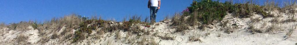
1 43 8 Ruakaka North - alternative vehicular beach access Reporting officer: Shireen Munday (Policy & Bylaws Analyst) Date of meeting: 16 December Purpose The purpose of this report is for Council to decide on an alternative vehicular access location on Ruakaka North beach. 2 Recommendation 1. That Whangarei District Council approve the location of a new vehicle access way to Ruakaka North Beach at Rama Road (Option 3 B). 2. That Whangarei District Council notes that staff will work in conjunction with the Department of Conservation and Northland Regional Council to complete the design work for the access track and obtain all associated consents and permits prior to beginning construction of the access track. 3 Executive summary There is a long history of community concern regarding human and vehicle conflict and associated safety issues on Ruakaka Beach. The Vehicles on Beaches Bylaw 2009 (the bylaw) provides a safe zone in the vicinity of the Ruakaka Surf Life Saving Club south of the Ruakaka River. Due to the only existing vehicle access for the beach north of the river being opposite the Ruakaka Racecourse, Council was unable to implement a safe zone in the vicinity of the Ruakaka Village without restricting all vehicles from the northern portion of the beach. Council directed staff to research the establishment of alternative vehicle access points north of Ruakaka Village to be able to review the safe zones of the bylaw. Two alternative access points have been researched and developed for Council s consideration. This report contains a staff recommendation that an access point off the end of Rama Road is developed in conjunction with the Department of Conservation and Northland Regional Council. Whangarei District Council 1 16 December 2015
2 44 4 Background In the years leading up to 2009, the Bream Bay community and others raised concerns about the frequency of vehicle use on the District s beaches. Issues raised included excessive and dangerous use of vehicles, concern for amenity values and environmental and wildlife protection concerns. In particular, the Ruakaka community was concerned about safety issues at two popular locations; the beach in front of the Ruakaka Surf Life Saving Club and the beach in front of the Ruakaka village north of the Ruakaka River. As a result of these concerns, Council made the Vehicles on Beaches Bylaw in November 2009, which created a safe zone in the vicinity of the Ruakaka Surf Life Saving Club, south of the Ruakaka River mouth. The implementation of this safety zone has gone well. Consideration was also given to the creation of a second safe zone in front of the Ruakaka Village north of the river mouth at that time. However, the only vehicular access point for the beach north of the river is located south of the Ruakaka Village at the Ruakaka Racecourse. This access point is not a formally constructed or authorised access point but a dune blowout that has historically been used to access the beach area. Council determined to proceed with the bylaw with the single safe zone, but also determined to research possible alternative access points to allow for a review of the bylaw safe zones in the future. Council staff have been working on identifying a potential suitable alternative vehicle access point since Since then Council has been updated on the progress and issues of the project via a number of workshops and potential options have been outlined. Three final possible options for consideration have now been identified which now form the discussion of this report. It is noted here that this report has not provided any analysis or discussion on a possible new safe zone in the vicinity of the Ruakaka Village in relation to the proposal. This analysis and discussion will be included in the project to review the Vehicles on Beaches Bylaw, which is anticipated to commence in mid This timing will allow for a potential amended bylaw to be finalised after public consultation and prior to the summer 2016/2017 season. 5 Discussion Staff have researched and reviewed three options for alternative vehicle access points to Ruakaka Beach north of the Ruakaka Village location (Attachment 4 map of Ruakaka North Beach). The land adjacent to the beach is largely either privately owned or under the control of the Department of Conservation (DOC). Some small portions are also under the control of Whangarei District Council (WDC), usually by way of a road reserve. The research undertaken focused on creating alternative access points through land either under the control of WDC or under the control of DOC. Staff of both organisations have been working together on the project. Northland Regional Council (NRC) has a long history with the establishment of the Vehicles on Beaches Bylaw and has an interest in the project in relation to its responsibilities in the Coastal Marine Area (CMA). As such NRC staff also joined the working group. In addition to land ownership considerations, there are important environmental issues that inform suitable alternative options. Whangarei District Council 2 16 December 2015
3 45 With dune access design, a range of factors must be considered. These include angling the access to prevent wind funneling, using a flexible and adjustable ramp surface (if one is to be used), provision to periodically manage sand levels at the access point, appropriate (re)- planting of native dunefield species (including potential restoration of nearby denuded areas) and protection measures for replanted areas (including fencing and signage). The design must also be configured so that it can be removed or adjusted in the event of exceptional beach changes as may happen over time. Accordingly, landscape architecture and coastal dynamics advice was commissioned and the associated issue of what type of access should be constructed has been raised with Council at previous workshops. Feedback and discussions to date have indicated that any new beach access should be of a minimalist design to protect the dune environment and soft, e.g., appropriate for four wheel drive (4WD) and all terrain vehicles (ATV) only. This type of design may also mean that the access way may be unusable for a period of time after a storm due to beach lowering. This would be consistent with the type of access currently provided at the Ruakaka Surf Life Saving Club and at Tip Road, Uretiti. Analysis undertaken regarding the types of vehicles using the beach area over the 2014/2015 summer period has shown that, during the data collection period, of a total of 894 vehicle movements to and from Ruakaka Beach, 871 were 4WDs, ATVs or tractors. This indicates that the majority of existing beach users will be able to continue accessing the beach using a new soft designed access point. Only 8 two wheel drive car movements were detected, with half of those requiring help for removal. This section provides an outline of each of the options developed and assessed. It is noted here that the option of closing the entire Ruakaka Beach north of the river mouth was not included in the options, as historically this has not been considered a viable option to progress at this time. Option 1 Status Quo The first option would be to retain the status quo. That is the existing vehicle access point would remain located at Ruakaka Racecourse and no new access point would be constructed. The outcome of this option would be that concerns regarding the safety of people in the vicinity of the Ruakaka Village and also the protection of wildlife in the northern portion of the Ruakaka Wildlife Refuge would not be able to be addressed through an amendment to the Vehicles on Beaches bylaw without restricting access on the entire beach area north of the Ruakaka River mouth. Sand blocking the road access to the race course would also remain an ongoing issue. Option 2 Vehicle access immediately north of Ruakaka Village Two different options have been assessed at this location. Option 2A is to further develop the existing pedestrian access to the beach in the vicinity of the carparking area adjacent to the NIWA facility (opposite the end of Ruakanohi Street). The land between the car park and the beach is owned by the Crown and was initially considered to be under the control of DOC. Further research established that the land is held by the Office of Treaty Settlements (OTS) and is land banked for those purposes (#968). WDC and DOC staff have undertaken detailed research on whether this land can be made available for an access track, by way of an agreement for an easement by the OTS as well as associated Iwi consents. Three Iwi have an interest in the land in question. Whangarei District Council 3 16 December 2015
4 46 Assistance from the Whangarei Member of Parliament was sought on a possible solution and staff have been further liaising with relevant Wellington central government departments on the issue. As a result of this work, it is considered that reaching an agreement between all relevant parties would be a lengthy process with no guarantee of achieving the overall goal of the project. Option 2B is to access the beach in the same vicinity at Option 2A, but to locate the access way on the WDC controlled road reserve that contains Te Kamo Street, which is adjacent to the Coastal Marine Area (CMA) of the beach. A concept design based on this option was presented to the community at a public meeting held at the Ruakaka Recreation Centre in December Feedback obtained at that time showed the community has strong concerns regarding the proposal, both for environmental reasons as well as community safety and noise concerns given the access points close proximity to the village. A key issue raised was the potential for conflict between vehicles and pedestrians accessing the beach at the same point. Option 3 Vehicle access track at Rama Road The third option is an access track via the WDC controlled road reserve at Rama Road, adjacent to the Carter Holt Harvey plant. The road reserve is currently sealed to a point just east of the plant entrance but runs all the way to the beach through the DOC Poupouwhenua Scenic Reserve adjacent to the beach. Discussions have been held with relevant DOC and NRC staff on this option. Option 3A is to create the access entirely within the WDC road reserve. However this raised considerable environmental concerns, due to the impact of the work on the fore dune area at that point, which is considered stable and reasonably intact (Attachment 1). Further investigation has shown there is a dune blowout approximately 275 metres north of the road reserve and that this is currently used informally as a vehicle access to the beach, utilising the Ruakaka Pipeline Track to access the blowout from the road reserve. To minimise the environmental impact of the construction of the access track, Option 3B was developed in conjunction with NRC and DOC. This would create an access way that would divert from Rama Road through the adjacent DOC reserve, either through a new track or using the existing pipeline track to then access the beach either directly where the existing blowout is or within the immediate vicinity subject to final engineering and design recommendations (Attachment 2). The working group has discussed Option 3 with Refining New Zealand, Vector and the Patuharakeke Trust Board. Refining New Zealand and Vector have no specific concerns regarding Option 3 and consider it may be beneficial in managing the current unauthorised usage of the pipeline track to access a number of dune blowouts along the beach. Patuharakeke Trust Board are not in favour of Option 3A due to the environmental impacts incurred but are in support of the Option 3B utilising the existing blowout area. In light of the feedback received from the community regarding Option 2, it is considered that an access point that is located away from residential activity and any pedestrian access points to the beach will alleviate those concerns raised regarding potential pedestrian and vehicle conflicts and provide a longer term solution for the community. Whangarei District Council 4 16 December 2015
5 47 Further work to finalise the design for Option 3B is needed, including final design/construction details and obtaining resources consents which are likely to be required from both WDC and NRC. Liaison will also be required with Vector and Refining NZ regarding the use of, or crossing, the pipeline track and any required design aspects to ensure the track does not adversely impact on the pipeline as well as any associated permits. Summary of Options Table 1 below summarises the options available together with their associated advantages and disadvantages. Option Advantages Disadvantages 1. Status Quo No change for existing vehicular beach users No costs to WDC 2A. OTS controlled land adjacent to NIWA 2B. Te Kamo Road Relatively simple construction. Short distance through the dune field. Fewer residents directly affected than an access point from Te Kamo Road. Is situated in a part of the beach with lower natural character and a high measure of dune degradation, so new development will have less impact on those values. Current access is in a poor state, difficult and dangerous to use. Potential liability issues for agencies. Perpetuates the process of dune field degradation and issues with sand being blown onto the racecourse access road. Future risk of the access being closed. No resolution for the existing conflict between vehicles and beach users. Vehicles would still be able to access the Wildlife Refuge and impact on nesting, feeding and roosting birds. Three Iwi have an interest in this land. Reaching agreement for its release would be a lengthy process and it is unlikely to get all relevant parties to agree to a vehicle entrance construction. Close proximity to NIWA who have not been consulted. Difficult construction. Difficult to maintain highly dependent on integrity of dune vegetation for durability. Crosses pedestrian access. Will impact on local residents and nearby properties. In close proximity of a heavily used section of the beach. Strongy opposed by local community. Whangarei District Council 5 16 December 2015
6 48 Option Advantages Disadvantages 3A. Rama Road road reserve only 3B. Rama Road & DOC Poupou whenua Scenic Reserve Paper road already exists as a legal corridor. Would simplify the management of the existing paper road/access, including construction options limiting the current unauthorised vehicular access in the surrounding vulnerable dune area. No residential area in vicinity so reduced risk of pedestrian/vehicle conflict. Located away from other pedestrian beach access points. As above. Creating a beach access utilising the existing track and the fore dune blowout would cause little extra damage. A new adjacent track and cut through the dune crest could create a superior gradient and the existing blowout could be repaired. Preferred option of Patuharakeke Trust Board and key stakeholders. Considerable damage incurred to break through the fore dune which is stable and reasonably intact. Dune crest is elevated and complex. Considerable length required through the back dune making it difficult to keep vehicles within the defined corridor. Consenting likely to be challenging due to the level of fresh adverse effects in a reasonably intact area. The legal road alignment is not related to the natural contour or fore dune profile. Considerable length required through back dune, making it difficult to keep vehicles within the defined corridor, although use of rocks could be used to manage this. Situated at a more dynamic end of the beach. Staff recommendation In assessing the advantages and disadvantages of the options presented, staff recommend proceeding with option 3B. It is considered that the issues highlighted in this report, together with the summarised advantages and disadvantages of each, indicate this option is the most feasible of all options presented. Additionally it is the preferred option for all members of the working group as well as the key stakeholders, in particular the Patuharakeke Trust Board. Ruakaka Racecourse access closure Should Council determine to proceed with the recommended option, this will allow for the closure of the Ruakaka Racecourse vehicle access point. The closure of the access point is supported by all working group members as well as the Ruakaka Racecourse (Whangarei Racing Club Inc) and the wider Ruakaka community. The works to be undertaken include repairing the existing blowout and creating a car park and pedestrian access point to the north of the blowout (Attachment 3). This work will be included in the overall implementation project for the new access point and will be completed once the new access point has been established. The Whangarei Racing Club Inc has confirmed that it is prepared to move its gate entrance in the vicinity of the proposed car park if necessary to accommodate a better overall outcome of the dune restoration aspect of the works. Whangarei District Council 6 16 December 2015
7 49 6 Considerations Financial/budget considerations Funding for the project, which includes contributions from DOC, as well as plants and planting activities from NRC for the dune rehabilitation aspects, has already been confirmed. WDC s contribution was included in the 2015 Long Term Plan for the 2015/2016 year. The budget for the work was based on Option 2 being implemented. Initial feedback on Option 3B is that because of the anticipated difference in construction and engineering required this option may be able to be achieved at a lesser cost than the current budgeted cost. Policy and planning implications Any new access point construction at Ruakaka Beach is likely to attract resource consent requirements from both WDC and NRC due to the nature and location of the work. WDC consents staff have advised that the site is within Coastal Hazard 1 and 2 and any earthworks on sand dune complexes require a discretionary activity resource consent. The design, construction and works will also have to align with any requirements of the New Zealand Coastal Policy Statement. Design and engineering work will have to be completed prior to consent applications being made. DOC staff will also complete an assessment for the work to be undertaken on the DOC controlled land of the project to ensure compliance with relevant reserve management bylaw in place on the reserve, as well as any other compliance and/or authorisation requirements. Risks The risk associated with the preferred option is that one or both of the resource consent applications and/or the consents and permits required from DOC, New Zealand Refining and Vector are not approved. This is considered a minor risk given the discussions held with key stakeholders to date and the support expressed for the preferred option. 7 Significance and Engagement Significance The decisions or matters of this report do not trigger the significance criteria outlined in Council s Significance and Engagement Policy. Engagement Due to the community interest in the proposed alternative access and the previous consultation activities undertaken, it is proposed to hold a public meeting in mid February 2016 at the Ruakaka Recreation Centre. The purpose of the meeting will be to inform the community of Council s decision regarding the alternative access location and the associated anticipated project timeframes. Attachments 1. End of Rama Road at beach intersection 2. Options for beach access off Rama Road 3. Ruakaka Racecourse access closure design 4. Map of Ruakaka North Beach Whangarei District Council 7 16 December 2015


8 50

9 Date Printed: 12 November Ruakaka - Marsden Point: Proposed Beach Access off Rama Road Legend SCALE 1: 6, Projection: NZGD_2000_New_Zealand_Transverse_Mercator Kilometers This map is a user generated static output from an Internet mapping site and is for reference only. Data layers that appear on this map may or may not be accurate, current, or otherwise reliable. THIS MAP IS NOT TO BE USED FOR NAVIGATION


10 52 0 ET 25 SC 50 m E R R CECO RSE PE ER SNE RO D m 5m PE ER E SN RO m 12 3 D m KEY NOTES with provision for camper vans to seaward 8 Path surface left as sand side. 9 Very solid concrete or steel bollards Beach access limited to pedestrians and well at 1.2m crs to prevent quads passing. defined (but not so heavily as to compromise 10 Wheelstops secured on piles or similar. dunefield character). 11 Parking bays founded on quarry run or Possible light structure to define access to granular brown rock overlaid with sand and beach and protect vulnerable foredune face. grassed to promote free drainage. Will require Narrow existing track to 1.5m and plant 12 regrading of verge to racecourse side and up margins. Some localised regarding required. to 500mm of fill to larger seaward bays. Filter entry with bollard. Define edges with low Sign illustrating dune process, wildlife issues post and rope barrier or similar to keep people and general beach care message using NRC within corridor. sign template as a starting point SC 10 m E E Y ESS R CECO RSE RES OR ON ND NEW C RP R Ref 1114 C BreamBay ccess Attach ment 3 3 Possible shift of racecourse gates to adjacent to new carpark to secure southern balance of road frontage to dunes 5 Regrade berm to remove accumulated sand and make easier to mow. Retrieved sand to go to base of dune blowout repair (kikuyu) 6 Fill, consolidate and grade blowout and adjacent areas to match profile of undamaged 7 dune. Salvage vegetation to replant. Plant all remaining areas to match natural composition. Ongoing management required Roadside parking bays to take 12 vehicles, 5 1


11 Ruakaka North Beach 53 P r i n t D a 7 t e / 1: 2 / P r i n t T i m1 1 e : 2 0 A M Scale: 1:38591 Original Sheet Size A3 P r o j e c t i o n N: Z G D / N e w Z e a l a n d T r a n s v e r s e M e r c a t o r B o u n d s : , , T h e i n f o r m a t i o n p r o v i d e d o n t h i s w e b s i t e i s i n t e n d e d t o b e g e n e r a l i n f o r m a t i o n o n l y. W h a n g a r e i D i s t r i c t C o u n c i l d o e s n o t a c c e p t a n y r e s p o n s i b i l i t y f o r c o n t e n t a n d s h a l l n o t b e r e s p o n s i b l e f a n d e x c l u d e s a l l l i a b i l i t y ; w i t h r e l a t i o n t o a n y c l a i m s w h a t s o e v e r a r i s i n g f r o m t h e u s e o f t h i s s i t e a n d d a t a h e U s e o f t h i s i n f o r m a t i o n i s i n c o n j u n c t i o n w i t h t h e G I S C o n d i t i o n s o f U s e.
23.1 RENEWABLE ENERGY
 Proposed Hastings District Plan as Amended 23.1 Renewable Energy 23.1 RENEWABLE ENERGY 23.1.1 INTRODUCTION The use of energy is of fundamental importance to the function and development of our society.
Construction Traffic Management Plan
 Construction Traffic Management Plan Proposed Additional Classroom Accommodation for Woolacombe Primary School Produced for and on behalf of Built Environments Team Devon County Council NPS South West
VEHICLE CROSSOVER INFORMATION PACK
 VEHICLE CROSSOVER INFORMATION PACK CONTENTS Introduction Section A Section B Section C Section D Section E Criteria for approving a vehicle crossover application (Diagrams to demonstrate measurement criteria)
SCHEDULE 2 TO THE DEVELOPMENT PLAN OVERLAY Shown on the planning scheme map as DPO2 WAVERLEY GOLF COURSE, LYSTERFIELD VALLEY
 SCHEDULE 2 TO THE DEVELOPMENT PLAN OVERLAY Shown on the planning scheme map as DPO2 WAVERLEY GOLF COURSE, LYSTERFIELD VALLEY 1.0 Conditions and requirements for permits A permit to use and develop the
Site Deliverability Statement Development at: Beech Lane, Kislingbury. Persimmon Homes Midlands March 2015
 Site Deliverability Statement Development at: Beech Lane, Kislingbury Persimmon Homes Midlands March 2015 Contents Site Deliverability Statement Development at: Beech Lane, Kislingbury 1.INTRODUCTION 1.1
LT McGuinness Site 10 Development, Wellington Waterfront. Construction Traffic Management Plan. 7 October 2014
 LT McGuinness Site 10 Development, Wellington Waterfront Construction Traffic Management Plan 7 October 2014 TDG Ref: 12950 141007 ltm ctmp final report.docx LT McGuinness Site 10 Development, Wellington
ASSESSMENT OF LANDCAPE PROVISIONS FOR PROPOSED PLAN CHANGE 1. Inner Business Zone. Outer Business Zone PALMERSTON NORTH CITY COUNCIL
 A division of Hudson Group Ltd ASSESSMENT OF LANDCAPE PROVISIONS FOR PROPOSED PLAN CHANGE 1 Inner Business Zone Outer Business Zone PALMERSTON NORTH CITY COUNCIL 1 2 A division of Hudson Group Ltd Prepared
Urban Vehicle Crossing Application To be completed and fees paid for prior to approval
 Urban Vehicle Crossing Application To be completed and fees paid for prior to approval Applicant Details Name: Postal Address: Telephone Home: Work: Signed: Date: Proposed Contractor: Proposed Start Date:
Welcome Welcome to the public exhibition for development at Bowman Field. This exhibition provides an overview of the proposals for the site.
 Welcome Welcome to the public exhibition for development at Bowman Field. This exhibition provides an overview of the proposals for the site. Background & Planning Context The Site The site is an area
PLANNING POLICY 3.3.5
 PLANNING POLICY 3.3.5 CHILD CARE PREMISES 1. Introduction A Child Care Premises is used to provide a child care service within the meaning of the Child Care Services Act 2007, but does not include a Family
WELCOME PROPOSALS FOR PENTAVIA RETAIL PARK WELCOME TO OUR EXHIBITION WHICH SETS OUT OUR PLANS TO DEVELOP THE PENTAVIA RETAIL PARK SITE.
 WELCOME WELCOME TO OUR EXHIBITION WHICH SETS OUT OUR PLANS TO DEVELOP THE PENTAVIA RETAIL PARK SITE. The purpose of the exhibition is to provide the community with the opportunity to view our initial ideas
Flood Protection & control works
 Flood Protection & control works Whakamarumaru i ngā waipuke Environment Canterbury is the joint lead agency with territorial authorities for flood risk reduction. Under changes to the Local Government
The purpose of this meeting is to inform the public of the updates to the project, and to get input before the finalization of the project.
 The purpose of this meeting is inform the public of the updates the project, and get input before the finalization of the project. The following panels describe the purpose and hisry of the project, along
CITY OF VINCENT CONSTRUCTION MANAGEMENT PLAN GUIDELINES
 CITY OF VINCENT CONSTRUCTION MANAGEMENT PLAN GUIDELINES INTRODUCTION What is a Construction Management Plan? The City of Vincent requires careful management of construction involving excavation and retention
K M D Hire Services, LONDON ROAD, NANTWICH, CW5 6LU
 Application No: 11/2196N Location: Proposal: Applicant: Expiry Date: K M D Hire Services, LONDON ROAD, NANTWICH, CW5 6LU Extension and New Store Mr Dan Mellor 17-Aug-2011 SUMMARY RECOMMENDATION Approve
BEST PRACTICE NOTE LANDSCAPE ASSESSMENT AND SUSTAINABLE MANAGEMENT 10.1 NZILA. Members Documentation
 BEST PRACTICE NOTE LANDSCAPE ASSESSMENT AND SUSTAINABLE MANAGEMENT 10.1 NZILA Members Documentation Background In August 2008, the New Zealand Institute of Landscape Architects (NZILA) Education Foundation
Significant investment and improvement of infrastructure and transport networks, delivered at no cost and no risk
 December 2014 FACT SHEET: TRANSPORT AND INFRASTRUCTURE Significant investment and improvement of infrastructure and transport networks, delivered at no cost and no risk The Gold Coast Integrated Resort
Tree Condition Survey for Proposed Taplow Footbridge at Ray Mill Island and Taplow Riverside, Mill Lane Taplow, Buckinghamshire
 Tree Condition Survey for Proposed Taplow Footbridge at Ray Mill Island and Taplow Riverside, Mill Lane Taplow, Buckinghamshire Tree Condition Survey for Proposed Taplow Footbridge at Ray Mill Island and
Department of State Development, Infrastructure and Planning. State Planning Policy state interest guideline. State transport infrastructure
 Department of State Development, Infrastructure and Planning State Planning Policy state interest guideline State transport infrastructure July 2014 Great state. Great opportunity. Preface Using this state
Shaping Whanganui. Have your say, korero mai
 Shaping Whanganui Have your say, korero mai Outer Commercial Design Guidelines Discussion Document Background The Outer Commercial zone of the District Plan sits on the outside of the central shopping
Temporary event application form Lake Karapiro
 If you require assistance with your booking or forms, help can be obtained from the following: Mighty River Domain at 07 827 4178 info@lakekarapiro.co.nz www.lakekarapiro.co.nz Waikato Regional Council
Ward: Purley DELEGATED BUSINESS MEETING Lead Officer: Head of Planning Control week of 23/03/2009
 Ward: Purley DELEGATED BUSINESS MEETING Lead Officer: Head of Planning Control week of 23/03/2009 Application No. 09/00389/LP - 51-61 Whytecliffe Road South, Purley, CR8 1. SUMMARY 1.1 This report concerns
DRAFT Policy to Guide Discretion on Proposed Relaxations to Minimum Parking Requirements in Commercial Districts City-Wide 2014 June 05
 PARKING INITIATIVES Attachment I Corridor Program Descriptions Corridor Program Pilot Though the Corridor Program will officially launch in the fall, this summer, The City will pilot the first phase of
Queens Park. Revised Draft Master Plan
 Queens Park Nature-Based Accommodation Revised Draft Master Plan Disclaimer This publication may be of assistance to you but the Great Ocean Road Coast Committee do not guarantee that it is without flaw
28.0 Development Permit Area #2 (Neighbourhood District)
") 28.0 Development Permit Area #2 (Neighbourhood District) Goals and Objectives To provide a guide for infill and new development in the Neighbourhood District. To outline the nature, form and character
28.0 Development Permit Area #2 (Neighbourhood District) Goals and Objectives To provide a guide for infill and new development in the Neighbourhood District. To outline the nature, form and character
Township of Georgian Bluffs POLICY USE OF UNOPENED ROAD ALLOWANCES
 Township of Georgian Bluffs POLICY USE OF UNOPENED ROAD ALLOWANCES 1.0 Background An unopened road allowance as defined by the Municipal Act is a public highway that has not been opened and assumed for
AGENT(S) / APPLICANT(S): AGENT Dave Dickerson, DK Architects. APPLICANT Halton Housing Trust. DEVELOPMENT PLAN ALLOCATION: Greenspace.
 / APPLICANT(S): AGENT Dave Dickerson, DK Architects. APPLICANT Halton Housing Trust. DEVELOPMENT PLAN ALLOCATION: Greenspace.") APPLICATION NO: 14/00168/FUL LOCATION: Land to the west of 19 Crow Wood Lane, Widnes. PROPOSAL: Proposed erection of 10 no. 1 bedroom apartments with individual access doors arranged in 2no. 2 storey height
APPLICATION NO: 14/00168/FUL LOCATION: Land to the west of 19 Crow Wood Lane, Widnes. PROPOSAL: Proposed erection of 10 no. 1 bedroom apartments with individual access doors arranged in 2no. 2 storey height
Construction Traffic Management Plan
 Introduction This (CTMP) has been prepared in order to discharge Condition 20 of planning permission ref 07/02879/EFUL for the enabling site works associated with the wider Bath Western Riverside development.
Proposed Heavy Equipment (Nortrax) Sales & Service Facility
 Sales & Service Facility") Proposed Heavy Equipment (Nortrax) Sales & Service Facility 130 David Manchester Road Planning Rationale Prepared by: McIntosh Perry Consulting Engineers Ltd. 115 Walgreen Road Carp, ON K0A 1L0 July 2013
Proposed Heavy Equipment (Nortrax) Sales & Service Facility 130 David Manchester Road Planning Rationale Prepared by: McIntosh Perry Consulting Engineers Ltd. 115 Walgreen Road Carp, ON K0A 1L0 July 2013
WESTFIELD-WASHINGTON ADVISORY PLAN COMMISSION December 7, 2015 1512-SPP-24 & 1512-ODP-24
 Petition Number: Subject Site Address: Petitioner: Request: East side of Oak Road, north of 151 st Street Langston Development Co. Primary Plat and Overall Development Plan amendment review for Mapleridge
720 Contour Grading. General. References. Resources. Definitions
 720 Contour Grading General Contour grading directs water to a desired point, prevents erosion, provides noise deflection, provides visual fit of the facility into the landscape, and protects desirable
Rural Development Strategy Network Utilities: Issues and Options
 Rural Development Strategy Network Utilities: Issues and Options Prepared by Carine Andries, Policy Planner Table of contents 1 Introduction... 3 2 Policy Framework... 3 2.1 National Level Policy... 3
1 Welcome. The exhibition comprises a series of boards which provide some background information to show you our initial ideas for the site.
 1 Welcome Thank you for taking the time to attend this public exhibition of our proposals for residential development on Land at Daws Farm, Back Road, Writtle (site shown opposite). The exhibition comprises
APPENDIX G. California Coastal Commission & Conservancy Accessibility Standards
 APPENDIX G California Coastal Commission & Conservancy Accessibility Standards STANDARDS AND RECOMMENDATIONS FOR ACCESSWAY LOCATION AND DEVELOPMENT These standards provide guidelines for the location,
Rural dwellings including bed and breakfast accommodation
 MORNINGTON PENINSULA SHIRE COUNCIL - INTERIM POLICY - JUNE 2011 Rural dwellings including bed and breakfast accommodation This policy applies to the use and development of land for a dwelling, including
DEVELOPMENT BRIEF FOR LAND AT ALLOA ROAD, TULLIBODY
 DEVELOPMENT BRIEF FOR LAND AT ALLOA ROAD, TULLIBODY 1.0 Introduction and Purpose 1.1 Clackmannanshire Council is seeking to dispose of a site at Alloa Road, Tullibody for redevelopment. The site extends
Figure 5.6a Construction worksites and corridor access Note: Indicative only, subject to detailed design.
 A 0 NORTH 200 metres George Lane worksite North Strathfield Station worksite Strath eld Triangle A B Existing rail corridor Proposed underpass approach New/extended bridge Worksites Existing track Proposed
Public Landscape Aids And Protection Of Assets
 Territory and Municipal Services Reference Document 4 LANDSCAPE MANAGEMENT AND PROTECTION PLANS (LMPP) Requirements for the Protection of Public Landscape Assets Adjacent to Development Works Issue 2 Revision
- 2 - Dave Gray (on behalf of Mr & Mrs Ward) - Silver Birch Tree Outside 13 Tirinui Crest Road (DC 210)
 - Silver Birch Tree Outside 13 Tirinui Crest Road (DC 210)") M13/53 TAURANGA CITY COUNCIL MINUTES OF THE TREE MANAGEMENT SUBCOMMITTEE DATE/TIME: VENUE: WEDNESDAY, 28 AUGUST 2013 : 1.00 P.M. TAURANGA CITY COUNCIL CHAMBER OPEN SECTION Members Present: Also Present:
M13/53 TAURANGA CITY COUNCIL MINUTES OF THE TREE MANAGEMENT SUBCOMMITTEE DATE/TIME: VENUE: WEDNESDAY, 28 AUGUST 2013 : 1.00 P.M. TAURANGA CITY COUNCIL CHAMBER OPEN SECTION Members Present: Also Present:
SANTA BARBARA COUNTY COMPREHENSIVE PLAN LOMPOC AREA
 SANTA BARBARA COUNTY COMPREHENSIVE PLAN LOMPOC AREA A. LAND USE ELEMENT INTERPRETIVE GUIDELINES B. COMMUNITY BENEFITS C. COUNTY ACTION ITEMS Adopted by the Board of Supervisors November 9, 1999 A. Santa
Development proposals will require to demonstrate, according to scale, type and location, that they:-
 Appendix 2 : Relevant Development Plan Policies Angus Local Plan Review 2009 Policy S1 : Development Boundaries (a) Within development boundaries proposals for new development on sites not allocated on
Revere Beach Transit-Oriented Development Parcels Revere, Massachusetts. Design and Development Guidelines. Part Two.
 Revere Beach Transit-Oriented Development Parcels Revere, Massachusetts Design and Development Guidelines Request for Qualifications and Expressions of Interest with Preliminary Development Plans Part
CONSTRUCTION TRAFFIC MANAGEMENT PLAN (CTMP)
") CONSTRUCTION TRAFFIC MANAGEMENT PLAN (CTMP) [Colston Budd Hunt & Kafes Pty Ltd AS AMENDED BY City of Sydney] 23 March 2010 1. PREAMBLE 1.1 This document constitutes the Demolition and Traffic Management
CONSTRUCTION TRAFFIC MANAGEMENT PLAN (CTMP) [Colston Budd Hunt & Kafes Pty Ltd AS AMENDED BY City of Sydney] 23 March 2010 1. PREAMBLE 1.1 This document constitutes the Demolition and Traffic Management
September 2005. Sponsored by: John H. Chafee Blackstone River Valley National Heritage Corridor Commission Woonsocket, RI
 Sponsored by: John H. Chafee Blackstone River Valley National Heritage Corridor Commission Woonsocket, RI Worcester Historical Museum Worcester, MA September 2005 mawald/ld/0909700/graphics/covers/september05cover
March 2008. Prepared by: Irvine Ranch Water District. 15600 Sand Canyon Avenue. Irvine, CA 92618. Contact: Natalie Likens (949) 453-5633
 453-5633") ADDENDUM TO THE MICHELSON WATER RECLAMATION PLANT PHASE 2 & 3 CAPACITY EXPANSION PROJECT FEBRUARY 2006 FINAL ENVIRONMENTAL IMPACT REPORT AND THE SAN JOAQUIN FRESHWATER MARSH ENHANCEMENT PLAN REVISED SEPTEMBER
ADDENDUM TO THE MICHELSON WATER RECLAMATION PLANT PHASE 2 & 3 CAPACITY EXPANSION PROJECT FEBRUARY 2006 FINAL ENVIRONMENTAL IMPACT REPORT AND THE SAN JOAQUIN FRESHWATER MARSH ENHANCEMENT PLAN REVISED SEPTEMBER
Stouffville Corridor Rail Service Expansion
 Stouffville Corridor Rail Service Expansion Stouffville Corridor Rail Service Expansion Class Environmental Assessment Study WELCOME PUBLIC INFORMATION CENTRE #2 Tuesday January 28, 2014 Agincourt Recreation
Report to INFRASTRUCTURE SERVICES Committee for noting
 15-377 Subject: Prepared by: Capital Works Programme 2015/16 Tairāwhiti Roads Alexios Kavallaris (Capital Manager - Tairāwhiti Roads) Meeting Date: 22 October 2015 Report to INFRASTRUCTURE SERVICES Committee
Triton Knoll Offshore Wind Farm Limited Electrical System. Outline Traffic Management Plan
 Triton Knoll Offshore Wind Farm Limited Electrical System Outline Traffic Management Plan October 2014 RWE Innogy UK Triton Knoll TMP Copyright 2014 RWE Innogy UK Ltd All pre-existing rights reserved.
ELEMENT 4 - FUTURE LAND USE ELEMENT
 ELEMENT 4 - FUTURE LAND USE ELEMENT Goal 1 To create a long-range development pattern which directs growth into developable areas and away from environmentally sensitive areas, in a manner that is compatible
Q&A: Resource Legislation Amendment Bill 2015
 Q&A: Resource Legislation Amendment Bill 2015 1. What are the four most significant changes in the Bill? The four most significant changes in the Resource Legislation Amendment Bill are: Requiring councils
13.4 REPORT TITLE: TRANSPORT MASTER PLAN PROPOSED PROCESS DATE OF MEETING: 15 DECEMBER 2008 TECHNICAL SERVICES INFRASTRUCTURE AND PROJECTS
 13.4 REPORT TITLE: TRANSPORT MASTER PLAN PROPOSED PROCESS DATE OF MEETING: 15 DECEMBER 2008 AUTHOR: AUTHOR S TITLE: REPRESENTORS: ATIS BERZINS MANAGER ENGINEERING AND TECHNICAL SERVICES N/A FILE NUMBER:
St. Clair College Planning Area Introduction
 Introduction What is the Study Area? St. Clair College Planning Area is bounded by Highway 3 to the west, Cabana Road to the north, the residential community of South Windsor to the east and Cousineau
Managing Public Use of Freeway Emergency Access Gates and Median Crossovers
 Managing Public Use of Freeway Emergency Access Gates and Median Crossovers Operational Instruction Transport Services Division TRAFFIC MANAGEMENT Operational Instructions Managing Public Use of Freeway
LIQUID WASTE TREATMENT FACILITY MENDIS ROAD, HUDSON CREEK DRAFT GUIDELINES FOR A PUBLIC ENVIRONMENTAL REPORT
 LIQUID WASTE TREATMENT FACILITY MENDIS ROAD, HUDSON CREEK DRAFT GUIDELINES FOR A PUBLIC ENVIRONMENTAL REPORT Introduction The purpose of this Public Environmental Report (PER) is to provide the Government
Key Facts. Passenger growth at the airport is projected to grow to approximately 3 million passengers per annum by 2030.
 Bournemouth Airport & Business Park 7 7 Bournemouth Airport & Business Park Introduction 7.1 Bournemouth Airport is a key asset for the region, one of the UK s fastest growing regional airports and is
Development Layout Design
 Development Layout Design General Design Considerations for Adoptable Highways Version 1 June 2012 Transportation, Waste and Environment Service Issue and Revisions Record Revision Date Originator Purpose
HIGHWAY DEPARTMENT ACCESS AND RIGHT OF WAY WIDTH GUIDELINES
 Approved 6/26/01 HIGHWAY DEPARTMENT ACCESS AND RIGHT OF WAY WIDTH GUIDELINES All new, modified and/or changed use access(es) onto county roads shall be subject to the access and corridor protection guidelines
PART FOUR Vision, Objectives and Policies
 PART FOUR Vision, Objectives and Policies VISION: To enhance the reserve as a Botanic Garden through improved plant collections and provide learning and passive recreation opportunities. 4.1 Plant Collections
2 Integrated planning. Chapter 2. Integrated Planning. 2.4 State highway categorisation and integrated planning
 2 Integrated planning Chapter 2 Integrated Planning This chapter contains the following sections: Section No. Topic 2.1 Introduction to integrated planning 2.2 Transit s Integrated Planning Policy 2.3
Guide to agrichemical use in Resource Management Plans Northland Region as at October 2011
 Guide to agrichemical use in Resource Management Plans Northland Region as at October 2011 Northland Regional Air Quality Plan Note: This guide is intended to assist users and applicators understanding
THIS PAGE INTENTIONALLY LEFT BLANK
 THIS PAGE INTENTIONALLY LEFT BLANK Construction Traffic Management Plan 2 Contents 1. Introduction... 4 1.1 Conditions of Consent... 4 2. Goals of the CTMP... 6 2.1 Objectives... 6 2.2 Predicted Construction
FILE NO.: Z-6915-C. Gamble Road Short-form PCD and Land Alteration Variance Request
 FILE NO.: Z-6915-C NAME: Gamble Road Short-form PCD and Land Alteration Variance Request LOCATION: Located on the Northwest corner of Chenal Parkway and Gamble Road DEVELOPER: Davis Properties P.O. Box
3. Given the geographic extent of the area, amendments have been made to the following regional planning documents
 AMENDMENTS TO THE REGIONAL PLANS RELATING TO LAND REPAIR ON EARTHQUAKE DAMAGED RESIDENTIAL LAND UNDER s27 OF THE CANTERBURY EARTHQUAKE RECOVERY ACT 2011 1. This memorandum outlines the specific changes
PLANNED UNIT DEVELOPMENT & SIDEWALK WAIVER REQUEST STAFF REPORT Date: November 7, 2013
 PLANNED UNIT DEVELOPMENT & SIDEWALK WAIVER REQUEST STAFF REPORT Date: November 7, 2013 NAME LOCATION Audubon Properties, LLC. 4700 & 4960 Dauphin Island Parkway West side of Dauphin Island Parkway, 580
Erection of replacement warehouse building and erection of two buildings in connection with builder s merchants
 Plan: O 02/00708/FUL Thames Ward (A) Address: Development: Applicant: London Works, Ripple Road, Barking Erection of replacement warehouse building and erection of two buildings in connection with builder
GUIDE TO SETTLEMENT OF CANTERBURY FLAT LAND CLAIMS
 GUIDE TO SETTLEMENT OF CANTERBURY FLAT LAND CLAIMS April 2013 i Introduction This guide focuses on repair methods for some of the types of land damage that occurred on flat residential land as a result
Assessment of Environmental Effects for the Lagoon/Drain Mouth Openings for Flood Mitigation. π Prepared for Hurunui District Council
 Assessment of Environmental Effects for the Lagoon/Drain Mouth Openings for Flood Mitigation π Prepared for Hurunui District Council π March 2010 P A T T L E D E L A M O R E P A R T N E R S L T D 1 Quality
BUILDING OVER OR NEAR WATER & SEWER MAINS POLICY
 MURRAY SHIRE COUNCIL BUILDING OVER OR NEAR WATER & SEWER MAINS POLICY ADOPTED: 1 May 2012 1 BUILDING OVER OR NEAR WATER AND SEWER MAINS POLICY CONTENTS 1. Objective... 2 2. Requirements for Building Near
Use of Council Open Space. Commercial Health and Fitness Providers. Terms and Conditions. 1. Introduction. 2. General principles
 Use of Council Open Space Terms and Conditions 1. Introduction The foreshore, parks and reserves are highly valued by the Frankston City community. Quality open spaces thoughout the community encourage
Application No.: 14.074 Steve Rush, representing Rocky Mountain Power Rocky Mountain Power Project Location: approximately 1600 N. 6800 E.
 Planning Commission Staff Report Planning and Development Services Croydon Substation Conditional Use Permit Public Meeting August 28, 2014 Application No.: 14.074 Applicant: Steve Rush, representing Rocky
Engagement with the community will be in accordance with Council s Community Participation Policy.
 CLARENCE CITY COUNCIL ASSET MANAGEMENT 7 DEC 2015 86 11.5 ASSET MANAGEMENT 11.5.1 CLARENCE STREET SAFETY ASSESSMENT PROJECT (File No 04-03-01) EXECUTIVE SUMMARY PURPOSE The purpose of this report is to
Welcome to the future of Terwillegar Park a Unique Natural Park
 Welcome to the future of Terwillegar Park a Unique Natural Park 1 Introduction The Terwillegar Park Concept Plan study will develop an overall concept plan, management objectives and development guidelines
Asset Management Guide For Project Design Format
 NZ Transport Agency Page 1 of 6 Asset Management Guide For Project Design Format 1 Background There has been an increasing awareness of design features, which produce poor wholeof-life costs. These poor
Seagull Intersection Layout. Island Point Road - A Case Study. Authors: John Harper, Wal Smart, Michael de Roos
 Seagull Intersection Layout. Island Point Road - A Case Study Authors: John Harper, Wal Smart, Michael de Roos Presented by Mr John Harper, Road Safety and Traffic Services Manager Phone: 4221 2456 Mobile:
AN INITIATIVE TO IMPROVE
 L OW E R C A R M E L R I V E R A N D L AG O O N F L O O D P L A I N R E S TO R AT I O N A N D E N H A N C E M E N T P R O J E C T AN INITIATIVE TO IMPROVE FLOOD PROTECTION RESTORE AND PROTECT RIPARIAN
Comment #1: Provide an interchange at Route 7 and Farm Market Road/White Gate Road. This was studied in the late 1990 s.
 Proposed Truck Climbing Lane Route 7 Westbound Between West Market Street and Route 9 UPC# 58599, Project # 6007-053-133, P101 Date of Meeting: August 24, 2010 Time: 6:00PM to 8:00PM Location: Rust Library
THE TOWN AND COUNTRY PLANNING ACT 1990 Grant of Planning Permission
 Civic Offices Havant Hampshire PO9 2AX Tel (023)9247 4174 Fax(023)9244 6588 DX50005 Havant www.havant.gov.uk To: ADP Architects Ltd Richmond Court 94 Botley Road Park Gate Southampton, Hants SO311BA For:
ASSET MANAGEMENT GUIDE FOR PROJECT DESIGN FORMAT
 ASSET MANAGEMENT GUIDE FOR PROJECT DESIGN FORMAT 1. BACKGROUND There has been an increasing awareness of design features, which produce poor whole-of-life costs. These poor whole-of-life costs manifest
Tree Management Policy
 Kingston District Council WE002 Tree Management Policy Keywords: Reference Number: WE002 Strategic Plan: Classification: Works & Engineering Policy First Issued/Approved: 2011 Review Frequency: Every 4
Alphington sewer replacement
 Alphington sewer replacement Frequently asked questions We understand you might have some questions for us so here are a few to provide you with more information. You are also welcome to call us on 1800
Chapter 3 CULVERTS. Description. Importance to Maintenance & Water Quality. Culvert Profile
 Chapter 3 CULVERTS Description A culvert is a closed conduit used to convey water from one area to another, usually from one side of a road to the other side. Importance to Maintenance & Water Quality
Site No 16 Vallis Trading Estate, Frome. Location
 Location Vallis Trading Estate is situated on the A362 Vallis Road in the Western Part of Frome. The surrounding uses are primarily residential with residential to the North, South and East. The former
How To Plan A Buffer Zone
 Backyard Buffers Protecting Habitat and Water Quality What is a buffer? A buffer (also called a riparian buffer area or zone) is the strip of natural vegetation along the bank of a stream, lake or other
3 September 9, 2015 Public Hearing
 3 September 9, 2015 Public Hearing APPLICANT: PI TELECOM INFRASTRUCTURE T, LLC PROPERTY OWNER: JSW HOLDINGS, LLC STAFF PLANNER: Carolyn A.K. Smith REQUEST: Conditional Use Permit (communications tower-monopole)
APPLICATION FOR PLANNING PERMISSION FOR A SOIL TREATMENT FACILITY AT KINGS CLIFFE LANDFILL SITE, STAMFORD, NORTHAMPTONSHIRE
 APPLICATION FOR PLANNING PERMISSION FOR A SOIL TREATMENT FACILITY AT KINGS CLIFFE LANDFILL SITE, STAMFORD, NORTHAMPTONSHIRE DESIGN AND ACCESS STATEMENT Report Reference: AU/KC/SPH/1449/01/D&A/FIN Baddesley
November 2006. General Notes. Tree Protection. Tree Protection and New Development Guidance Note
 Tree Protection and New Development Guidance Note November 2006 General Notes The retention and planting of trees within a development can add to the character and aesthetic value of a site whilst maintaining
Mission Creek Flood Control & Restoration Project. City of Fremont, Alameda County
 Mission Creek Flood Control & Restoration Project City of Fremont, Alameda County Agenda Background Why are proposed improvements necessary? Proposed project components Challenges Construction schedule/phasing
22.01 SETTLEMENT 24/04/2014 C73
 22.01 SETTLEMENT 24/04/2014 C73 22.01-1 Urban Growth and Development 24/04/2014 C73 This policy applies to the urban areas and fringes of Portland, Heywood, Casterton, Dartmoor, Nelson, Cape Bridgewater,
Pow Beck, St Bees to Seascale promenade
 www.naturalengland.org.uk Chapter 2: Pow Beck, St Bees to Seascale promenade Coastal Access: Whitehaven to Silecroft - Natural England s Proposals Part 2.1: Introduction Start Point: Pow Beck, St Bees
DESIGN ASSISTANCE APPLICATION
 DESIGN ASSISTANCE APPLICATION for FY 2016 NEW RIVER MULTI USE PATH: PINNACLE PEAK ROAD TO HAPPY VALLEY ROAD CITY OF PEORIA APPLICATIONS ARE DUE VIA ONLINE SUBMITTAL BY 10:00 AM ON MONDAY, JUNE 29, 2015
2010 Salida Community Priorities Survey Summary Results
 SURVEY BACKGROUND The 2010 Salida Community Priorities Survey was distributed in September in an effort to obtain feedback about the level of support for various priorities identified in the draft Comprehensive
Environmental Guidelines for Preparation of an Environmental Management Plan
 2013 Environmental Guidelines for Preparation of an Environmental Management Plan Environmental Management Division Environmental Protection Agency 3/13/2013 ENVIRONMENTAL GUIDELINES FOR PREPARATION OF
K M D Hire Services, LONDON ROAD, NANTWICH, CW5 6LU
 Application No: 11/2196N Location: Proposal: Applicant: Expiry Date: K M D Hire Services, LONDON ROAD, NANTWICH, CW5 6LU Extension and New Store Mr Dan Mellor 17-Aug-2011 SUMMARY RECOMMENDATION Approve
SITE INVESTIGATIONS OF THE BEACH EROSION PROBLEM AT MAHO BEACH, ST. MAARTEN
 SITE INVESTIGATIONS OF THE BEACH EROSION PROBLEM AT MAHO BEACH, ST. MAARTEN Performed February 2003 Performed by: Dr. Lee E. Harris, Ph.D., P.E. Associate Professor of Ocean Engineering & Oceanography
CHAPTER 24: ENVIRONMENTAL MANAGEMENT
 Central Eyre Iron Project Environmental Impact Statement CHAPTER 24: ENVIRONMENTAL MANAGEMENT CHAPTER 24 ENVIRONMENTAL MANAGEMENT COPYRIGHT Copyright Iron Road Limited, 2015 All rights reserved This document
Household waste & recycling storage requirements
 South Gloucestershire Council Guidance for Developers on Household waste & recycling storage requirements INTRODUCTION As part of the Council s aim to improve the quality of life for residents as well
CONSENT, PURSUANT TO SECTIONS 34A, 88, 104, 104C, and 108 OF THE RESOURCE MANAGEMENT ACT, IS GRANTED. THE FULL DECISION IS SET OUT BELOW
 A U C K L A N D C O U N C I L Decision following the hearing of an application for resource consent SUBJECT: Application for resource consent under section 88 of the Resource Management Act 1991 by D C
Project Management Fact Sheet:
 Project Management Fact Sheet: Project Documentation Version: 2.2, November 2008 DISCLAIMER This material has been prepared for use by Tasmanian Government agencies and Instrumentalities. It follows that
1. REPORT CONTEXT Description of the development (include all of the following that are known at the time of the application):
:") Transportation Assessment and Management Study Guidelines for Consultants INTRODUCTION This document is intended to provide guidelines for transportation consultants who produce Transportation reports
Transportation Assessment and Management Study Guidelines for Consultants INTRODUCTION This document is intended to provide guidelines for transportation consultants who produce Transportation reports
approval of matters specified in conditions; and The Town and Country Planning (Development Management Procedure) (Scotland) Regulations 2013
 (Scotland) Regulations 2013") Application for: planning permission; planning permission in principle; further applications; approval of matters specified in conditions; and mineral workings (if the planning authority do not have a
Application for: planning permission; planning permission in principle; further applications; approval of matters specified in conditions; and mineral workings (if the planning authority do not have a