Planning Tools related to water in Promotional Complex Forest Western Sudety Mountains
|
|
|
- Hilda Berry
- 8 years ago
- Views:
Transcription


1 Planning Tools related to water in Promotional Complex Forest Western Sudety Mountains Radomir Balazy Forest Research Institute
2 Content 1. Introduction 2. Technologies of data collection 3. Examples of applications
3 Introduction The average standing volume in Poland is 226 m3/ha and the average stand age is 60 years. The total area of forestland in Poland is 9 million hectares forests in Poland are mainly publicly-owned 82 %, including the forests under the management of the State Forests 78.0 % of the total Coniferous forest habitats predominate in the habitat structure, accounting for 55 % of the total forest area, while broadleaved forest habitats cover 45 % Coniferous species dominate in Polish forests, covering nearly three fourth of the total forest area
4 Introduction 29,1 %
5 Introduction Organization of State Forests 17 Regional Directorates of State Forests 430 Districts forestry Directorate General of State Forests 17 companies of the State Forests of regional 7 National Forests companies nationwide 25,000 Employees

6 Introduction Forestry 5599 Directorate General of the State Forest Director General of the State Forest State Forest Council Inspection Regions Forest District 431 National Organization Units 7 Forest Services 2 Regional Directorate of the SF 17 Forest Protections Teams 17 Forest Transport 2 Fisheries Holdings 2
7 Introduction
8 Introduction
9 Introduction
10 Content 1. Introduction 2. Technologies of data collection 3. Examples of applications
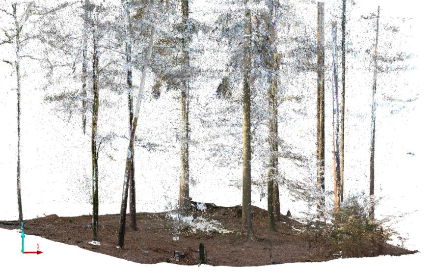
11 Mobil mapping system A vehicle used for making a survey of roads following an MMS method

12 Mobil mapping system
13 Aerial and satellite data
 Tile Size Swath Width Maximum Strip Length Revisit Time Blue Green Red Red")

14 Aerial and satellite data Spectral Bands Satellite Altitude Ground Sampling Distance (Nadir) Pixel Spacing (orthorectified) Tile Size Swath Width Maximum Strip Length Revisit Time Blue Green Red Red Edge NIR 630 km 6.5 m 5 m 25 x 25 km² 77 km 1500 km DAILY nm nm nm nm nm Equator crossing time 11:00 a.m. (approximately) Image Capture Capacity 4 Million km² DAILY
15 Aerial and satellite data
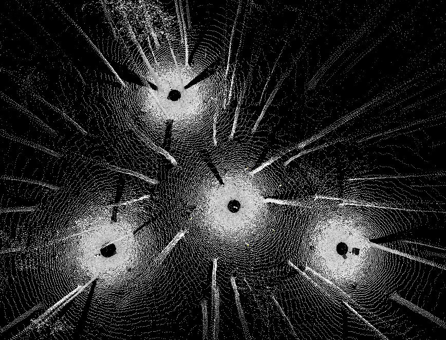
16 Terrestrial laser scanning
17 Airborn laser scanning


18 Data from meteorological stations Visualization of the location of meteorological stations, including the building of the Świeradów Forest District which houses a server collecting data
19 Content 1. Introduction 2. Technologies of data collection 3. Examples of applications
20 Automatically generated water-courses including the flow accumulation marked in red of varius intensity
21 Comparison of water-courses generated automatically on the basis of DTM (in blue) and water-courses placed on the map during forest management activities (in red)
22 Generated drainage basins in Western Sudety Mountains
23 Visualization of the duration of water run-of to the border of the model including the drainage basin
24 drainage system DSM in the Izera mountain moor protected area
25 DSM in the Izera mountain moor protected area
26 DSM in the Izera mountain moor protected area
27 Virtual barrage in the old drainage system
28 Virtual barrages in the old drainage system
29 Virtual barrages in the old drainage system
30 Nursury in Swieradow Forest District
31 Nursury in Swieradow Forest District
32 Nursury in Swieradow Forest District (13 cm pixelsize)
33 DTM
34 DTM and flood bank


35 6-7 SIERPIEŃ 2006 DSM
36 Flood bank on DTM
37 Flood simulation
38 DTM with forest stand map superimposed
39 DTM with forest stand map superimposed
40 Flood simulation 1 stage
41 Flood simulation 2 stage
42 Flood simulation 3 stage
43 Flood simulation 4 stage
44 Flood simulation 5 stage
45 Simulation of flooding on DSM with natural texture
46 Thank you
Krzysztof Stereńczak, Radomir Bałazy. Forest Research Institute, Warsaw
 Establishment of a forest information system covering the area of the Sudetes and the West Beskids with respect to the forest condition monitoring and assessment project presentation Krzysztof Stereńczak,
2.3 Spatial Resolution, Pixel Size, and Scale
 Section 2.3 Spatial Resolution, Pixel Size, and Scale Page 39 2.3 Spatial Resolution, Pixel Size, and Scale For some remote sensing instruments, the distance between the target being imaged and the platform,
CARBON BALANCE IN BIOMASS OF MAIN FOREST TREE SPECIES IN POLAND
 CARBON BALANCE IN BIOMASS OF MAIN FOREST TREE SPECIES IN POLAND PAWEŁ STRZELIŃSKI Department of Forest Management Poznan University of Life Science TOMASZ ZAWIŁA-NIEDŹWIECKI Forest Research Institute in
OUTLINES. Earth Observation Satellite Program of Vietnam and applications for disaster management
 UNESCAP ICC & HLDM Meetings, Bangkok 26 28/11/2013 Earth Observation Satellite Program of Vietnam and applications for disaster management OUTLINES 1. VNREDSat-1 (VAST*) - Optical 2. VNREDSat-1B (VAST)
Using Remote Sensing Imagery to Evaluate Post-Wildfire Damage in Southern California
 Graham Emde GEOG 3230 Advanced Remote Sensing February 22, 2013 Lab #1 Using Remote Sensing Imagery to Evaluate Post-Wildfire Damage in Southern California Introduction Wildfires are a common disturbance
MULTIPURPOSE USE OF ORTHOPHOTO MAPS FORMING BASIS TO DIGITAL CADASTRE DATA AND THE VISION OF THE GENERAL DIRECTORATE OF LAND REGISTRY AND CADASTRE
 MULTIPURPOSE USE OF ORTHOPHOTO MAPS FORMING BASIS TO DIGITAL CADASTRE DATA AND THE VISION OF THE GENERAL DIRECTORATE OF LAND REGISTRY AND CADASTRE E.ÖZER, H.TUNA, F.Ç.ACAR, B.ERKEK, S.BAKICI General Directorate
Spectral Response for DigitalGlobe Earth Imaging Instruments
 Spectral Response for DigitalGlobe Earth Imaging Instruments IKONOS The IKONOS satellite carries a high resolution panchromatic band covering most of the silicon response and four lower resolution spectral
Digital Image Increase
 Exploiting redundancy for reliable aerial computer vision 1 Digital Image Increase 2 Images Worldwide 3 Terrestrial Image Acquisition 4 Aerial Photogrammetry 5 New Sensor Platforms Towards Fully Automatic
How To Make An Orthophoto
 ISSUE 2 SEPTEMBER 2014 TSA Endorsed by: CLIENT GUIDE TO DIGITAL ORTHO- PHOTOGRAPHY The Survey Association s Client Guides are primarily aimed at other professionals such as engineers, architects, planners
3D Model of the City Using LiDAR and Visualization of Flood in Three-Dimension
 3D Model of the City Using LiDAR and Visualization of Flood in Three-Dimension R.Queen Suraajini, Department of Civil Engineering, College of Engineering Guindy, Anna University, India, suraa12@gmail.com
Appendix C - Risk Assessment: Technical Details. Appendix C - Risk Assessment: Technical Details
 Appendix C - Risk Assessment: Technical Details Page C1 C1 Surface Water Modelling 1. Introduction 1.1 BACKGROUND URS Scott Wilson has constructed 13 TUFLOW hydraulic models across the London Boroughs
Review for Introduction to Remote Sensing: Science Concepts and Technology
 Review for Introduction to Remote Sensing: Science Concepts and Technology Ann Johnson Associate Director ann@baremt.com Funded by National Science Foundation Advanced Technological Education program [DUE
Resolutions of Remote Sensing
 Resolutions of Remote Sensing 1. Spatial (what area and how detailed) 2. Spectral (what colors bands) 3. Temporal (time of day/season/year) 4. Radiometric (color depth) Spatial Resolution describes how
National Inventory of Landscapes in Sweden
 Key messages Approaching the landscape perspective in monitoring experiences in the Swedish NILS program Johan Svensson, Future Forest Monitoring, 091112 Landscape level approaches are necessary to deal
Mapping coastal landscapes in Sri Lanka - Report -
 Mapping coastal landscapes in Sri Lanka - Report - contact : Jil Bournazel jil.bournazel@gmail.com November 2013 (reviewed April 2014) Table of Content List of Figures...ii List of Tables...ii Acronyms...ii
Hyperspectral Satellite Imaging Planning a Mission
 Hyperspectral Satellite Imaging Planning a Mission Victor Gardner University of Maryland 2007 AIAA Region 1 Mid-Atlantic Student Conference National Institute of Aerospace, Langley, VA Outline Objective
AN INTEGRATED WORKFLOW FOR LIDAR / OPTICAL DATA MAPPING FOR SECURITY APPLICATIONS
 AN INTEGRATED WORKFLOW FOR LIDAR / OPTICAL DATA MAPPING FOR SECURITY APPLICATIONS Dirk Tiede, Thomas Blaschke Z_GIS; Centre for GeoInformatics, University of Salzburg, Hellbrunnerstrasse 34, 5020 Salzburg,
River Flood Damage Assessment using IKONOS images, Segmentation Algorithms & Flood Simulation Models
 River Flood Damage Assessment using IKONOS images, Segmentation Algorithms & Flood Simulation Models Steven M. de Jong & Raymond Sluiter Utrecht University Corné van der Sande Netherlands Earth Observation
Electromagnetic Radiation (EMR) and Remote Sensing
 and Remote Sensing") Electromagnetic Radiation (EMR) and Remote Sensing 1 Atmosphere Anything missing in between? Electromagnetic Radiation (EMR) is radiated by atomic particles at the source (the Sun), propagates through
Electromagnetic Radiation (EMR) and Remote Sensing 1 Atmosphere Anything missing in between? Electromagnetic Radiation (EMR) is radiated by atomic particles at the source (the Sun), propagates through
CONTINUING EROSION IN SOUTHEASTERN COASTAL MISSISSIPPI - POINT AUX CHENES BAY, WEST GRAND BAY, MIDDLE BAY, GRANDE BATTURE ISLANDS: 1995-1997
 Summary of a Poster Presented at the: Sixty-Second Annual Meeting of the Mississippi Academy of Sciences in Biloxi, Mississippi February 26-27, 1998 ===============================================================
'Developments and benefits of hydrographic surveying using multispectral imagery in the coastal zone
 Abstract With the recent launch of enhanced high-resolution commercial satellites, available imagery has improved from four-bands to eight-band multispectral. Simultaneously developments in remote sensing
China Earth Observation
 China High-resolution Earth Observation China Earth Observation System (CHEOS) and its Lastest Development The Earth Observation System and Data Center, CNSA 2014-2 Outlines 1 Introduction 2 The composition
ViaLight. Communications
 ViaLight Communications ViaLight Communications Laser Communication for Aerial Applications ViaLight Communications (VLC) is a spin-off company from the German Aerospace Center DLR, founded in 2009. The
Forests of the Czech Republic, State Enterprise Hluboká nad Vltavou Forest District
 Forests of the Czech Republic, State Enterprise Hluboká nad Vltavou Forest District Hluboká n.vl. Forest District GPS n 49.06049 e 14.43311 1 Stará Obora Lodge GPS n 49.08437 e 14.45508 3 Stará Obora Hunting
Using Remote Sensing to Monitor Soil Carbon Sequestration
 Using Remote Sensing to Monitor Soil Carbon Sequestration E. Raymond Hunt, Jr. USDA-ARS Hydrology and Remote Sensing Beltsville Agricultural Research Center Beltsville, Maryland Introduction and Overview
Monitoring Soil Moisture from Space. Dr. Heather McNairn Science and Technology Branch Agriculture and Agri-Food Canada heather.mcnairn@agr.gc.
 Monitoring Soil Moisture from Space Dr. Heather McNairn Science and Technology Branch Agriculture and Agri-Food Canada heather.mcnairn@agr.gc.ca What is Remote Sensing? Scientists turn the raw data collected
Core Imagery Product Guide. v. 2.0
 Core Imagery Product Guide v. 2.0 Disclaimer & Copyright Copyright 2014 DigitalGlobe, Inc. All rights reserved. The DigitalGlobe s Core Imagery Product Guide is purposely designed as a general guideline
TerraColor White Paper
 TerraColor White Paper TerraColor is a simulated true color digital earth imagery product developed by Earthstar Geographics LLC. This product was built from imagery captured by the US Landsat 7 (ETM+)
High Resolution Digital Surface Models and Orthoimages for Telecom Network Planning
 Renouard, Lehmann 241 High Resolution Digital Surface Models and Orthoimages for Telecom Network Planning LAURENT RENOUARD, S ophia Antipolis FRANK LEHMANN, Berlin ABSTRACT DLR of Germany and ISTAR of
Accuracy test of 3D modelling for buffer strip calculation and land monitoring. SIN spa - Rome
 Accuracy test of 3D modelling for buffer strip calculation and land monitoring D. Biscontini, L. Rossi, P. Tosi S. Di Ielsi, F. Manzi, M.A.DelMoro SIN spa - Rome Digital Surface Model at high resolution
AirborneHydroMapping. New possibilities in bathymetric and topographic survey
 AirborneHydroMapping New possibilities in bathymetric and topographic survey AIRBORNE HYDROMAPPING (2008 2011) Layout needs from water engineering side: - Shallow water applications - High point density
COASTAL MONITORING & OBSERVATIONS LESSON PLAN Do You Have Change?
 Coastal Change Analysis Lesson Plan COASTAL MONITORING & OBSERVATIONS LESSON PLAN Do You Have Change? NOS Topic Coastal Monitoring and Observations Theme Coastal Change Analysis Links to Overview Essays
Nature Values Screening Using Object-Based Image Analysis of Very High Resolution Remote Sensing Data
 Nature Values Screening Using Object-Based Image Analysis of Very High Resolution Remote Sensing Data Aleksi Räsänen*, Anssi Lensu, Markku Kuitunen Environmental Science and Technology Dept. of Biological
Application of airborne remote sensing for forest data collection
 Application of airborne remote sensing for forest data collection Gatis Erins, Foran Baltic The Foran SingleTree method based on a laser system developed by the Swedish Defense Research Agency is the first
LiDAR for vegetation applications
 LiDAR for vegetation applications UoL MSc Remote Sensing Dr Lewis plewis@geog.ucl.ac.uk Introduction Introduction to LiDAR RS for vegetation Review instruments and observational concepts Discuss applications
WILLOCHRA BASIN GROUNDWATER STATUS REPORT 2009-10
 WILLOCHRA BASIN GROUNDWATER STATUS REPORT 2009-10 SUMMARY 2009-10 The Willochra Basin is situated in the southern Flinders Ranges in the Mid-North of South Australia, approximately 50 km east of Port Augusta
Laser Ranging to Nano-Satellites
 13-0222 Laser Ranging to Nano-Satellites G. Kirchner (1), Ludwig Grunwaldt (2), Reinhard Neubert (2), Franz Koidl (1), Merlin Barschke (3), Zizung Yoon (3), Hauke Fiedler (4), Christine Hollenstein (5)
Using Optech LMS to Calibrate Survey Data Without Ground Control Points
 Challenge An Optech client conducted an airborne lidar survey over a sparsely developed river valley. The data processors were finding that the data acquired in this survey was particularly difficult to
ADAGUC & PyTROLL. Maarten Plieger Ernst de Vreede. Application of polar orbiter products in weather forecasting Using open source tools and standards
 Application of polar orbiter products in weather forecasting Using open source tools and standards ADAGUC & PyTROLL Maarten Plieger Ernst de Vreede Royal Netherlands Meteorological Institute (KNMI) R&D
ONE METER AND BELOW HIGH RESOLUTION SATELLITES IN PRODUCTION
 ONE METER AND BELOW HIGH RESOLUTION SATELLITES IN PRODUCTION A. Demirel, I. Bayir Inta Space Turk (Space Imaging Eurasia), Haymana Yolu 12.Km 06830 Golbasi Ankara, TURKEY (ibayir@spaceturk.com.tr, ademirel@spaceturk.com.tr)
5. GIS, Cartography and Visualization of Glacier Terrain
 5. GIS, Cartography and Visualization of Glacier Terrain 5.1. Garhwal Himalayan Glaciers 5.1.1. Introduction GIS is the computer system for capturing, storing, analyzing and visualization of spatial and
Soil degradation monitoring by active and passive remote-sensing means: examples with two degradation processes
 Soil degradation monitoring by active and passive remote-sensing means: examples with two degradation processes Naftaly Goldshleger, *Eyal Ben-Dor,* *Ido Livne,* U. Basson***, and R.Ben-Binyamin*Vladimir
Rural Flooding: The Potential Role of Forestry
 Rural Flooding: The Potential Role of Forestry Nadeem Shah, Tom Nisbet, & Huw Thomas Centre for Forestry and Climate Change Structure Background Woodland and Flood Alleviation The Theory. Studies on Woodland
EVALUATION OF AIRBORNE LIDAR DIGITAL TERRAIN MAPPING FOR HIGHWAY CORRIDOR PLANNING AND DESIGN
 Waheed Uddin Director, Center for Advanced Infrastructure Technology, Carrier Hall 203 The University of Mississippi, University, MS 38677-1848, USA cvuddin@olemiss.edu KEY WORDS: Terrain, mapping, airborne,
Full Waveform Digitizing, Dual Channel Airborne LiDAR Scanning System for Ultra Wide Area Mapping
 Full Waveform Digitizing, Dual Channel Airborne LiDAR Scanning System for Ultra Wide Area Mapping RIEGL LMS-Q56 high laser pulse repetition rate up to 8 khz digitization electronics for full waveform data
The X100. Safe and fully automatic. Fast and with survey accuracy. revolutionary mapping. create your own orthophotos and DSMs
 The X100 revolutionary mapping Safe and fully automatic create your own orthophotos and DSMs Fast and with survey accuracy operates even in harsh weather conditions (up to 65 km/h wind & light rain) Image
Advanced Image Management using the Mosaic Dataset
 Esri International User Conference San Diego, California Technical Workshops July 25, 2012 Advanced Image Management using the Mosaic Dataset Vinay Viswambharan, Mike Muller Agenda ArcGIS Image Management
Text and photos: Juha Siekkinen, Life+ Return of Rural Wetlands Cover drawing: Jari Kostet Maps and aerial photos: National Land Survey of Finland
 Life+ Return of Rural Wetlands Pikku Nuoluanjärvi Wetlands, Liminka Text and photos: Juha Siekkinen, Life+ Return of Rural Wetlands Cover drawing: Jari Kostet Maps and aerial photos: National Land Survey
COMPARISON OF AERIAL IMAGES, SATELLITE IMAGES AND LASER SCANNING DSM IN A 3D CITY MODELS PRODUCTION FRAMEWORK
 COMPARISON OF AERIAL IMAGES, SATELLITE IMAGES AND LASER SCANNING DSM IN A 3D CITY MODELS PRODUCTION FRAMEWORK G. Maillet, D. Flamanc Institut Géographique National, Laboratoire MATIS, Saint-Mandé, France
INTA AIRBORNE REMOTE SENSING FACILITY from the Hasselblad s cameras to the SensyTech-AHS sensor
 INTA AIRBORNE REMOTE SENSING FACILITY from the Hasselblad s cameras to the SensyTech-AHS sensor José-Antonio Gómez-Sánchez gomezsj@inta.es Remote Sensing Laboratory INSTITUTO NACIONAL DE TÉCNICA AEROESPACIAL
Testing the Suitability of Spatial Printing Technology for Engineering Applications (for Presentation of Topographic Surface)***
***") GEOMATICS AND ENVIRONMENTAL ENGINEERING Volume 8 Number 3 2014 http://dx.doi.org/10.7494/geom.2014.8.3.17 Krzysztof Chmielnicki*, Konrad Eckes** Testing the Suitability of Spatial Printing Technology for
GEOMATICS AND ENVIRONMENTAL ENGINEERING Volume 8 Number 3 2014 http://dx.doi.org/10.7494/geom.2014.8.3.17 Krzysztof Chmielnicki*, Konrad Eckes** Testing the Suitability of Spatial Printing Technology for
SPOT Satellite Earth Observation System Presentation to the JACIE Civil Commercial Imagery Evaluation Workshop March 2007
 SPOT Satellite Earth Observation System Presentation to the JACIE Civil Commercial Imagery Evaluation Workshop March 2007 Topics Presented Quick summary of system characteristics Formosat-2 Satellite Archive
VIIRS-CrIS mapping. NWP SAF AAPP VIIRS-CrIS Mapping
 NWP SAF AAPP VIIRS-CrIS Mapping This documentation was developed within the context of the EUMETSAT Satellite Application Facility on Numerical Weather Prediction (NWP SAF), under the Cooperation Agreement
INTEGRATED GEOPHYSICAL AND REMOTE SENSING STUDIES ON GROTTA GIGANTE SHOW CAVE (TRIESTE ITALY) P. Paganini, A. Pavan, F. Coren, A.
 P. Paganini, A. Pavan, F. Coren, A.") INTEGRATED GEOPHYSICAL AND REMOTE SENSING STUDIES ON GROTTA GIGANTE SHOW CAVE (TRIESTE ITALY) P. Paganini, A. Pavan, F. Coren, A. Fabbricatore Aerial lidar survey - strumentation Piper Seneca II - PA34
INTEGRATED GEOPHYSICAL AND REMOTE SENSING STUDIES ON GROTTA GIGANTE SHOW CAVE (TRIESTE ITALY) P. Paganini, A. Pavan, F. Coren, A. Fabbricatore Aerial lidar survey - strumentation Piper Seneca II - PA34
Computer Vision: Machine Vision Filters. Computer Vision. Optical Filters. 25 August 2014
 Computer Vision Optical Filters 25 August 2014 Copyright 2001 2014 by NHL Hogeschool, Van de Loosdrecht Machine Vision BV and Klaas Dijkstra All rights reserved j.van.de.loosdrecht@nhl.nl, jaap@vdlmv.nl,
Stanfords For Business. Price List. Stanfords For Business Price List - 1 -
 - 1 - Stanfords For Business Price List Stanfords Digital 29 Corn Street, BS1 1HT CONTENTS - Stanfords For Business Price List - 2 - OS Master Map in dxf/ dwg/ shp format 3 Planning Application Maps 4
Report 2005 EUR 21579 EN
 Feasibility study on the use of medium resolution satellite data for the detection of forest cover change caused by clear cutting of coniferous forests in the northwest of Russia Report 2005 EUR 21579
RS platforms. Fabio Dell Acqua - Gruppo di Telerilevamento
 RS platforms Platform vs. instrument Sensor Platform Instrument The remote sensor can be ideally represented as an instrument carried by a platform Platforms Remote Sensing: Ground-based air-borne space-borne
CBERS Program Update Jacie 2011. Frederico dos Santos Liporace AMS Kepler liporace@amskepler.com
 CBERS Program Update Jacie 2011 Frederico dos Santos Liporace AMS Kepler liporace@amskepler.com Overview CBERS 3 and 4 characteristics Differences from previous CBERS satellites (CBERS 1/2/2B) Geometric
Remote Sensing Satellite Information Sheets Geophysical Institute University of Alaska Fairbanks
 Remote Sensing Satellite Information Sheets Geophysical Institute University of Alaska Fairbanks ASTER Advanced Spaceborne Thermal Emission and Reflection Radiometer AVHRR Advanced Very High Resolution
METHODOLOGY FOR LANDSLIDE SUSCEPTIBILITY AND HAZARD MAPPING USING GIS AND SDI
 The 8th International Conference on Geo-information for Disaster Management Intelligent Systems for Crisis Management METHODOLOGY FOR LANDSLIDE SUSCEPTIBILITY AND HAZARD MAPPING USING GIS AND SDI T. Fernández
MODIS IMAGES RESTORATION FOR VNIR BANDS ON FIRE SMOKE AFFECTED AREA
 MODIS IMAGES RESTORATION FOR VNIR BANDS ON FIRE SMOKE AFFECTED AREA Li-Yu Chang and Chi-Farn Chen Center for Space and Remote Sensing Research, National Central University, No. 300, Zhongda Rd., Zhongli
Chapter Contents Page No
 Chapter Contents Page No Preface Acknowledgement 1 Basics of Remote Sensing 1 1.1. Introduction 1 1.2. Definition of Remote Sensing 1 1.3. Principles of Remote Sensing 1 1.4. Various Stages in Remote Sensing
HIGH RESOLUTION REMOTE SENSING AND GIS FOR URBAN ANALYSIS: CASE STUDY BURITIS DISTRICT, BELO HORIZONTE, MINAS GERAIS
 HIGH RESOLUTION REMOTE SENSING AND GIS FOR URBAN ANALYSIS: CASE STUDY BURITIS DISTRICT, BELO HORIZONTE, MINAS GERAIS Hermann Johann Heinrich Kux Senior Researcher III INPE, Remote Sensing Division DAAD
Use of OGC Sensor Web Enablement Standards in the Meteorology Domain. in partnership with
 Use of OGC Sensor Web Enablement Standards in the Meteorology Domain in partnership with Outline Introduction to OGC Sensor Web Enablement Standards Web services Metadata encodings SWE as front end of
Coastal Engineering Indices to Inform Regional Management
 Coastal Engineering Indices to Inform Regional Management Lauren Dunkin FSBPA 14 February 2013 Outline Program overview Standard products Coastal Engineering Index Conclusion and future work US Army Corps
Object-based classification of remote sensing data for change detection
 ISPRS Journal of Photogrammetry & Remote Sensing 58 (2004) 225 238 www.elsevier.com/locate/isprsjprs Object-based classification of remote sensing data for change detection Volker Walter* Institute for
2002 URBAN FOREST CANOPY & LAND USE IN PORTLAND S HOLLYWOOD DISTRICT. Final Report. Michael Lackner, B.A. Geography, 2003
 2002 URBAN FOREST CANOPY & LAND USE IN PORTLAND S HOLLYWOOD DISTRICT Final Report by Michael Lackner, B.A. Geography, 2003 February 2004 - page 1 of 17 - TABLE OF CONTENTS Abstract 3 Introduction 4 Study
The National Strategy, Current Activities for Space Technology Development and Application
 14-18 November 2011, Putrajaya, Malaysia The National Strategy, Current Activities for Space Technology Development and Application Lai Anh Khoi Space Technology Institute, VAST, Vietnam Bief History Space
GIS SYSTEM FOR 3D VISUALIZATION OF HYDRODYNAMIC MODELING OF FLOOD FLOWS IN RIVER VALLEYS
 GIS SYSTEM FOR 3D VISUALIZATION OF HYDRODYNAMIC MODELING OF FLOOD FLOWS IN RIVER VALLEYS Edyta Hadaś 1 Abstract Currently available and common techniques of spatial data acquisition enable to acquire three-dimensional
Remote sensing and GIS applications in coastal zone monitoring
 Remote sensing and GIS applications in coastal zone monitoring T. Alexandridis, C. Topaloglou, S. Monachou, G.Tsakoumis, A. Dimitrakos, D. Stavridou Lab of Remote Sensing and GIS School of Agriculture
Evaluation of Forest Road Network Planning According to Environmental Criteria
 American-Eurasian J. Agric. & Environ. Sci., 9 (1): 91-97, 2010 ISSN 1818-6769 IDOSI Publications, 2010 Evaluation of Forest Road Network Planning According to Environmental Criteria Amir Hosian Firozan,
ForeCAST : Use of VHR satellite data for forest cartography
 ForeCAST : Use of VHR satellite data for forest cartography I-MAGE CONSULT UCL- Dpt Sciences du Milieu et de l Aménagement du Territoire Description of the partnership I-MAGE Consult Private partner Team
USE OF VERY HIGH-RESOLUTION AIRBORNE IMAGES TO ANALYSE 3D CANOPY ARCHITECTURE OF A VINEYARD
 USE OF VERY HIGH-RESOLUTION AIRBORNE IMAGES TO ANALYSE 3D CANOPY ARCHITECTURE OF A VINEYARD S. Burgos a, *, M. Mota a, D. Noll a, B. Cannelle b a University for Viticulture and Oenology Changins, 1260
SILVA FENNICA. Detection of the need for seedling stand tending using high-resolution remote sensing data
 SILVA FENNICA Silva Fennica vol. 47 no. 2 article id 952 Category: research article www.silvafennica.fi ISSN-L 0037-5330 ISSN 2242-4075 (Online) The Finnish Society of Forest Science The Finnish Forest
Information Contents of High Resolution Satellite Images
 Information Contents of High Resolution Satellite Images H. Topan, G. Büyüksalih Zonguldak Karelmas University K. Jacobsen University of Hannover, Germany Keywords: satellite images, mapping, resolution,
Mapping Earth from Space Remote sensing and satellite images. Remote sensing developments from war
 Mapping Earth from Space Remote sensing and satellite images Geomatics includes all the following spatial technologies: a. Cartography "The art, science and technology of making maps" b. Geographic Information
A remote sensing instrument collects information about an object or phenomenon within the
 Satellite Remote Sensing GE 4150- Natural Hazards Some slides taken from Ann Maclean: Introduction to Digital Image Processing Remote Sensing the art, science, and technology of obtaining reliable information
Moderate- and high-resolution Earth Observation data based forest and agriculture monitoring in Russia using VEGA Web-Service
 Moderate- and high-resolution Earth Observation data based forest and agriculture monitoring in Russia using VEGA Web-Service Sergey BARTALEV and Evgeny LOUPIAN Space Research Institute, Russian Academy
FUSION OF INSAR HIGH RESOLUTION IMAGERY AND LOW RESOLUTION OPTICAL IMAGERY
 FUSION OF INSAR HIGH RESOLUTION IMAGERY AND LOW RESOLUTION OPTICAL IMAGERY J. Bryan Mercer a*, Dan Edwards a, Gang Hong b, Joel Maduck a, Yun Zhang b a Intermap Technologies Corp., Calgary, Canada, bmercer@intermap.com
Development of a forest stand top-height model for Airborne Laser Scanning Data (ALS)
") Development of a forest stand top-height model for Airborne Laser Scanning Data (ALS) Under the project ForseenPOMERANIA 2 Table of content 3 Airborne Laser Scanning (ALS) got more and more priority for
Development of a forest stand top-height model for Airborne Laser Scanning Data (ALS) Under the project ForseenPOMERANIA 2 Table of content 3 Airborne Laser Scanning (ALS) got more and more priority for
Recent advances in Satellite Imagery for Oil and Gas Exploration and Production. DESK AND DERRICK APRIL 2016 PRESENTED BY GARY CREWS---RETIRED
 Recent advances in Satellite Imagery for Oil and Gas Exploration and Production. DESK AND DERRICK APRIL 2016 PRESENTED BY GARY CREWS---RETIRED Agenda Brief review of state of the applications in 2010 Basics
Calculation of Minimum Distances. Minimum Distance to Means. Σi i = 1
 Minimum Distance to Means Similar to Parallelepiped classifier, but instead of bounding areas, the user supplies spectral class means in n-dimensional space and the algorithm calculates the distance between
RESOLUTION MERGE OF 1:35.000 SCALE AERIAL PHOTOGRAPHS WITH LANDSAT 7 ETM IMAGERY
 RESOLUTION MERGE OF 1:35.000 SCALE AERIAL PHOTOGRAPHS WITH LANDSAT 7 ETM IMAGERY M. Erdogan, H.H. Maras, A. Yilmaz, Ö.T. Özerbil General Command of Mapping 06100 Dikimevi, Ankara, TURKEY - (mustafa.erdogan;
www.nams.au.com National Asset Management Strategy Australia
 DEVELOPMENT OF A ROAD ASSET REGISTER USING DIGITAL VIDEO TECHNOLOGY DUNGOG SHIRE COUNCIL Matt Ryeland, mailto:matthew.ryeland@cardno.com.au Senior Technical Officer, Management Services. Cardno Terry Wilson,
Gatekeeper Systems. NaviGate USA (Underground Service Alert) Software Product Description. Product Summary. Product Description.
 Software Product Description. Product Summary. Product Description.") NaviGate USA (Underground Service Alert) Software Product Description Product Summary The NaviGate USA (Underground Service Alert) Module provides interfaces to Call-Before-You-Dig call centers so that
NaviGate USA (Underground Service Alert) Software Product Description Product Summary The NaviGate USA (Underground Service Alert) Module provides interfaces to Call-Before-You-Dig call centers so that
Evaluation of surface runoff conditions. scanner in an intensive apple orchard
 Evaluation of surface runoff conditions by high resolution terrestrial laser scanner in an intensive apple orchard János Tamás 1, Péter Riczu 1, Attila Nagy 1, Éva Lehoczky 2 1 Faculty of Agricultural
LIDAR Data visualization and the Silviculture of PervasION Data
 FUSING LIDAR DATA, PHOTOGRAPHS, AND OTHER DATA USING 2D AND 3D VISUALIZATION TECHNIQUES Robert J. McGaughey, Research Forester Ward W. Carson, Research Engineer USDA Forest Service Pacific Northwest Research
Fuels Treatments Reduce Wildfire Suppression Cost Merritt Island National Wildlife Refuge May 2012
 Fuels Treatments Reduce Wildfire Suppression Cost Merritt Island National Wildlife Refuge May 2012 Merritt Island National Wildlife Refuge Where Technology and Nature Intersect Authors Jennifer Hinckley
Armenian State Hydrometeorological and Monitoring Service
 Armenian State Hydrometeorological and Monitoring Service Offenbach 1 Armenia: IN BRIEF Armenia is located in Southern Caucasus region, bordering with Iran, Azerbaijan, Georgia and Turkey. The total territory
REGISTRATION OF LASER SCANNING POINT CLOUDS AND AERIAL IMAGES USING EITHER ARTIFICIAL OR NATURAL TIE FEATURES
 REGISTRATION OF LASER SCANNING POINT CLOUDS AND AERIAL IMAGES USING EITHER ARTIFICIAL OR NATURAL TIE FEATURES P. Rönnholm a, *, H. Haggrén a a Aalto University School of Engineering, Department of Real
REPORT TO REGIONAL WATER SUPPLY COMMISSION MEETING OF WEDNESDAY, SEPTEMBER 4, 2013 LEECH WATER SUPPLY AREA RESTORATION UPDATE
 Making a difference... together Agenda Item #9 REPORT #RWSC 2013-17 REPORT TO REGIONAL WATER SUPPLY COMMISSION MEETING OF WEDNESDAY, SEPTEMBER 4, 2013 SUBJECT LEECH WATER SUPPLY AREA RESTORATION UPDATE
Cloud Masking and Cloud Products
 Cloud Masking and Cloud Products MODIS Operational Algorithm MOD35 Paul Menzel, Steve Ackerman, Richard Frey, Kathy Strabala, Chris Moeller, Liam Gumley, Bryan Baum MODIS Cloud Masking Often done with
 European Forest Data Centre Biosoil/Biodiversity Forest Type Map 2006 P. Kempeneers, JRC T. Durant F. Sedano, JRC L. Seebach, JRC J. San-Miguel-Ayanz, JRC EC -, IES Land Management and Natural Hazard Unit
Opportunities for the generation of high resolution digital elevation models based on small format aerial photography
 Opportunities for the generation of high resolution digital elevation models based on small format aerial photography Boudewijn van Leeuwen 1, József Szatmári 1, Zalán Tobak 1, Csaba Németh 1, Gábor Hauberger
Beasley Lake Watershed National Sedimentation Laboratory Water Quality & Ecology Research Unit USDA ARS Oxford, Mississippi
 Beasley Lake Watershed National Sedimentation Laboratory Water Quality & Ecology Research Unit USDA ARS Oxford, Mississippi M. A. Locke, S. S. Knight, C. M. Cooper, S. Smith, Jr., M. T. Moore, F. D. Shields,
REPUBLIC OF TURKEY MINISTRY OF FORESTRY AND WATER AFFAIRS
 REPUBLIC OF TURKEY MINISTRY OF FORESTRY AND WATER AFFAIRS Turkey s position in the World Prof. Dr. Veysel EROĞLU Minister of Forestry and Water Affairs The Ministry of Forestry and Water Affairs, formerly
REMOTE SENSING FOR FOREST RESOURCE MANAGEMENT: CCRS ADVANCES IN ELECTRO-OPTICAL AND RADAR IMAGING SYSTEMS
 REMOTE SENSING FOR FOREST RESOURCE MANAGEMENT: CCRS ADVANCES IN ELECTRO-OPTICAL AND RADAR IMAGING SYSTEMS S.M. Till, A.L. Gray and F.J. Ahern Canada Centre for Remote Sensing 2464 Sheffield Road, Ottawa,
Avison Management Services Ltd. COMPANY PROFILE
 Avison Management Services Ltd. COMPANY PROFILE Providing resource management through environmental leadership. Mission Statement: We are committed to providing high quality, timely, and cost effective
Pavement Asset Management Guidance Section 5.3: Condition Surveying and Rating - Drainage
 Pavement Asset Management Guidance Section 5.3: Condition Surveying and Rating - Drainage December 2014 Document Information Title Author Description Pavement Asset Management Guidance, Section 5.3: Condition