AN IMPORTANT MIDDLE BRONZE AGE CEMETERY AT WEST-CENTRAL ANATOLIA: DEDE MEZARI
|
|
|
- George Anthony
- 8 years ago
- Views:
Transcription
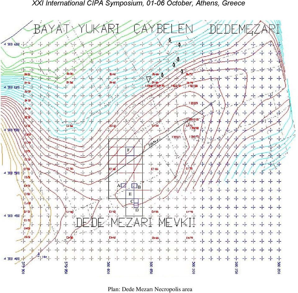
1 AN IMPORTANT MIDDLE BRONZE AGE CEMETERY AT WEST-CENTRAL ANATOLIA: DEDE MEZARI O. Kocak a, M. Uyumez b, T. Cay c, A. Ilasli b, F. Iscan c a Selcuk University Faculty of Science and Letters, Department of History, Konya-TURKEY, ozdekocak@hotmail.com b Director of the Afyon Museum, Afyon-TURKEY, muyumaz@hotmail.com c Selcuk University Faculty of Engineering and Architecture, Department of Geodesy and Photogrammetry Konya- TURKEY, (tcay, fiscan)@selcuk.edu.tr KEYWORDS: Dede Mezarı Cemetery, Middle Bronze Age, Early Hittite Period, topographical map, geophysical work, Köy Kalesi. ABSTRACT Systematic work was performed at the Dede Mezarı Cemetery in We started with geodesic work and continued by laying grids in the planned excavation area. This excavation was carried out by the Afyonkarahisar Archaeological Museum with permission from the Ministry of Culture and Tourism. In , an excavation was carried out at the Dede Mezarı cemetery in Yukarı Çaybelen village, district of Bayat, province of Afyonkarahisar. The results show that this cemetery was in use from the beginning of the 2. Millenium B.C. to the middle of this millenium. There are some problems with this region of West-Central Anatolia concerning especially the Assyrian Trade Colonies Period and the Early Hittite Period. This research area is one of the few cemeteries dated to this period. The findings from this cemetery are contemporary with, and give the same results as, the findings at Yanarlar (10 km to the Northwest), at the Çavlum and Demircihöyük-Sarıket cemeteries in Eskişehir. Drawing the cadastre began only recently and property maps have not yet been prepared. Points P.30, P.31 and P.39 were used in the topography, and grids were laid out. over the whole of the Dede Mezarı. In addition, a 10m x 10m. plan of the 200m x 200m area was prepared. We continued with geophysical work in an area of 4500 m² where the excavation would be carried out. This helped us to determine the first area to be excavated. We took three human bone fragments from graves which were analyzed by the Beta Analytic Radiocarbon Dating Laboratory. According to these analyses, the samples from the graves date to between B. C. These radiocarbon analyses concur with our evaluation of the archaeological findings. 1. LOCATION OF THE DEDE MEZARI CEMETERY The Köy Kalesi settlement is located 500 m west of Yukarı Çaybelen Village (Yukarı Maçaklı), 50 m west of the Cevizli road and 30 m east of the Havuzun Başı Deresi (Map)(Koçak, 2004, 48). There is some agricultural activity on the settlement. The field extends from northwest to southeast (N ; E: ; h: 1300). The length northwest-southeast is 160 m, the length southwest-northeast is 110 m and the elevation is 21 m. There are Bronze Age sherds and stone implements here. The Köy Kalesi has to be the settlement of the Dede Mezarı Cemetery, because of its localization and findings dating to the Middle Bronze Age (MBA). Gavur İni Önü Cemetery was another field examined in the Köy Kalesi area. It is situated on a slope 200 m. south of the Köy Kalesi settlement and 600 m west of Yukarı Çaybelen. An Early Bronze Age (EBA) large pithos graves and sherds were found here. Dede Mezarı Cemetery is 400 m west of Yukarı Çaybelen, on the ridge of the Havuzun Başı Deresi and 400 m southeast of the Köy Kalesi mound. This excavation conducted under the supervision of the Afyon Archaeological Museum demonstrates that this may be a MBA cemetery (Figure 1, Map, Plan). This project (no ) is sponsored by the Selçuk University BAP West-Central Anatolia s links to the West in the Early Periods. We would like to express our gratitude to the coordinators. Corresponding author Ozdemir Kocak, Assoc. Prof., Selcuk University Faculty of Science and Letters, Department of History, Konya-TURKEY, ozdekocak@hotmail.com

2 XXI International CIPA Symposium, October, Athens, Greece The other was placed in / plan square and called as F trench (Figure 4, Plan) Trench E E1 pithos grave was located in the northwest of Trench E. This grave was destroyed by illegal excavators. In the deep part of this grave there was a pot made of clay. We discovered three bronze rings in the same place. Figure 1: Dede Mezarı There are important MBA cemeteries in West-Central Anatolia and in Western Anatolia. The most important of them is Yanarlar Cemetery, which is situated 10 km northwest of Yukarı Çaybelen (Emre, 1978, 65). Besides this, the Çavlum Cemetery 16 km east of Eskişehir is another which yields characteristic regional MBA materials (Bilgen, 2002, 60; Bilgen, 2004, 142, Bilgen, 2005, 44). There are also findings dated to this period in Kusura, 45 km southwest of Afyonkarahisar. Figure 2: Trench E Yanarlar, Çavlum, Sarıket and Dede Mezarı are contemporary sites and their findings are similar. One may say that these yielded unique materials characteristic of the MBA that are uncommon in this part of Anatolia (Emre, 1978, 15 ff; Bilgen, 2002, 60; Bilgen, 2004, 139 ff). Asarcık, Bozyer and Dura Yeri are the other cemeteries and settlements in the region, which broaden our knowledge about the West-Central Anatolian MBA cultures (Özgüç, 1974, 151; Lloyd-Mellaart, 1965, 76 ff ). The two parallel and adjacent huge stones were dug out in the west-southwest of Trench E. This is the cemetary of E2 cist grave (Figure 3). A breaking over the geologic filling which was discovered has an oval shape. The base of this grave was discovered over a flattened cist layer. Flat,huge and block stones were used around the four sides of the grave. There is an obstacle(rubble) caused by huge stones leaning to the the southeast of the grave. We discovered bone fragments in the east side of the grave. 2. GEODESIC AND GEOPHYSICAL STUDIES Systematic work was performed at the Dede Mezarı Cemetery in We started with geodesic work and continued by laying grids in the planned excavation area. This excavation was carried out by the Afyonkarahisar Archaeological Museum with permission from the Ministry of Culture and Tourism. Drawing the cadastre began only recently and property maps have not yet been prepared. Points P.30, P.31 and P.39 were used in the topography, and grids were laid out. over the whole of the Dede Mezarı. In addition, a 10m x 10m. plan of the 200m x 200m area was prepared. We continued with geophysical work in an area of 4500 m² where the excavation would be carried out. This helped us to determine the first area to be excavated. 3. THE EXCAVATION OF DEDE MEZARI CEMETERY 2006 Figure 3: E2 cist grave The excavation studies were planned in two regions 10x10 m size at the Dede Mezarı Cemetery in 2006 and the it has been performed succesfully. We discovered a pithos grave (E3) which was partly destroyed in the middle of Trench E. The fragments of the bones alone were just recognized in the pithos grave. The part of the mouth was covered by the stones. One of them was placed in / plan squares and called E trench (Figure 2, Plan). A destroyed pithos grave (E4) was discovered in the southmiddle of Trench E. There were huge stones on the upper side
.")
3 XXI International CIPA Symposium, October, Athens, Greece of the pithos grave. Bone fragments were discovered. The pithos grave was located over a region in which an oval-shaped grave hole was being dug up. The grave was destroyed from illegal excavators. The fragments of a pithos which was completely oxide was discovered in the grave hole. The findings of stones and bones in the northeast corner of the Trench E indicate that there might have been a double buried grave (E5). Trench F F1 pithos grave was located in the southeast corner of the Trench F. The rim of pithos was surrounded and supported by stones. The body of the pithos extended to the bottom of the cist layer. Bone fragments and metal pieces were discovered. F2 buried grave was constructed in a rectangle hollow by digging the geologic filling in the east-middle of Trench F. And it was covered by three flat stones. Sherds of potteries were discovered over the rock-carved grave. In this simple grave a human skeleton was discovered. F3 pithos grave was located in the northeast corner of the Trench F and was probably destroyed by illegal excavators. Some sherds of potteries and bones fragments were found here. Figure 5: Northwest side of Trench F There was a F8 pithos grave next to the F5 pithos grave (Figure 5, 6). This pithos was situated in an area which was acquired by the excavating of the cist layer according to the shape of pithos. Also a second pithos was inserted into this pithos. We discovered cremation remains and next to them were pieces of beads. Figure 4: Trench F F4 pithos grave was located in the southwest corner of the Trench F. The rim of the pithos was surrounded and supported by stones. We dug in the F5 pithos grave in the middle northwest of Trench F. We discovered decorated metal ornaments, a piece of needle and pieces of beads. Also three potteries were discovered on the rim of the F5 pithos (Figure 5). We dug in the F6 simple grave in the northwest corner of Trench F. The grave was located over a region in which an oval-shaped cist layer was dug up and the upper side was covered by stones. An extramural buried grave was discovered. Figure 6: F8 pithos grave There were three canals, extended to the southwest-northeast in a parallel way in the Trench F. The MBA graves were not demolished by the canals. The graves were almost connected to each other. Learning the functions of the canals left us in vain. Further information may be obtained after excavations that will be carried out in a future. The discovered bones were examined by the team from the anthropology Department of Ankara University.
.")
4 4. CONCLUSION Our excavation area, Dede Mezarı Cemetery, is located on the Paşadağ range. The fields of the cemeteries in this region have similar geographical shapes and yield similar materials, which lead us to the conclusion that there was once a common cultural MBA group in the eastern part of the Afyon region. These components were spread across a wide area as in the findings at Kütahya and Eskişehir. There are many MBA necropolises and settlements in Paşadağ and its surroundings where there are the necropolises of Yanarlar and Dedemezarı around it in the East of Afyon. Asarcık, Bozyer, Dura Yeri, Çalışlar are the main necropolis areas and Köy Kalesi, Asarcık Höyük (Bayat), Söğütlüpınar (Bayat), İnlerönü (İscehisar Doğlat Village), Çalışlar (İscehisar Çalışlar Village), Çayır 1 (Emirdağ Gözeli Village) are the main settlements from these. Apart from these, as we have enlighten above, it is known that many findings in this period and region were handed over to the Archaeological Museum in Afyon. Contrary to the thoughts, this region had intensity in settlement and limited knowledge of the region about MBA is due to the lack of surveys. REFERENCES Akyurt, İ. M. 1998, M. Ö. 2. Binde Anadolu da Ölü Gömme Adetleri, Ankara. Bilgen, A. N. 2002, Çavlum Köyü Mezarlığı Eskişehir Alpu Ovası nda Yeni Bir Orta Tunç Çağı Mezarlığı, Anadolu Üniversitesi, Edebiyat Fakültesi Dergisi, I-3, Bilgen, A. N. 2004, 2002 Yılı Çavlum Köyü Mezarlık Kazısı, Kazı Sonuçları Toplantısı, XXV/1, Bilgen, A. N. 2005, Çavlum, Eskişehir Alpu Ovası nda Bir Orta Tunç Çağ Mezarlığı, Eskişehir. Emre, K. 1978, Yanarlar, Afyon Yöresinde Bir Hitit Mezarlığı, A Hittite Cemetery Near Afyon, Ankara. Koçak, Ö. 2004, Erken Dönemlerde Afyonkarahisar Yerleşmeleri, Kömen Yayınevi, Konya. Lloyd, S.-Mellart, J. 1965, Beycesultan, Vol.II, Middle Bronze Age Architecture And Pottery, London. Özgüç, T. 1974, Five Vessels Belonging to the Late Assyrian Trading Colony Period, BaM (Baghdader Mitteilungen), 7, Map: Some Important Necropolis in Turkey (Akyurt, 1998, map 1)

5 Plan: Dede Mezarı Necropolis area
Field Report: Caere Project 2015
 Bryn Critz Schockmel Boston University History of Art and Architecture Field Report: Caere Project 2015 This summer I had the pleasure of participating in the Caere Project, led by Professor Fabio Colivicchi
ALGORITHM DEVELOPING FOR LAND CONSOLIDATION SOFTWARE
 ALGORITHM DEVELOPING FOR LAND CONSOLIDATION SOFTWARE T. Cay a, F. Iscan a a Selcuk University, Engineering and Architecture Faculty, Geodesy and Photogrammetry Department, 42075 Konya, TURKEY ( tcay, fiscan
An Archaeological Settlement Analysis of Goshono Site
 An Archaeological Settlement Analysis of Goshono Site TAKADA Kazunori YAMADA Masahisa 1. The Planar Distribution of Remains Goshono is a late-middle Jomon settlement site in Iwate Prefecture, Ninohe County,
Hopewell Archeology: The Newsletter of Hopewell Archeology in the Ohio River Valley Volume 6, Number 1, September 2004
 Hopewell Archeology: The Newsletter of Hopewell Archeology in the Ohio River Valley Volume 6, Number 1, September 2004 5. New Discoveries Right in Our Own Front Yard: Preliminary Results of Recent Research
Labraunda 2012. Preliminary report
 Labraunda 2012. Preliminary report The excavations at Labraunda this year were very successful and lasted for eight weeks. Our main new discovery is obviously the gold coin from Philip II discovered in
CURRICULUM VITAE PERSONEL INFORMATION
 CURRICULUM VITAE PERSONEL INFORMATION Family Name ÇETE Name MEHMET Title Ph.D. Date of Birth 1975 Place of Birth Denizli, Turkey Gender Male Marital Status Married ACADEMIC BACKGROUND & WORK EXPERIENCE
Bedwyn Brail, Wiltshire: Geophysical and Earthworks Survey
 Bedwyn Brail, Wiltshire: Geophysical and Earthworks Survey Report no. 167.0306 & 167.0506 Authors L. Amadio MSc & B. Clarke MSc Date October 2012 Acknowledgement Wiltshire Archaeological and Natural History
Field School Scholarship, I had the opportunity to attend the American Excavations at
 Jane C. Waldbaum Field School Scholarship Report Sarah K. Gorman, Old Dominion University This summer, thanks to the generous support of the Jane C. Waldbaum Archaeological Field School Scholarship, I
Works on the Geographical Information System (GIS) in the Ancient Town Kelenderis in Turkey
 in the Ancient Town Kelenderis in Turkey") Works on the Geographical Information System (GIS) in the Ancient Town Kelenderis in Turkey S. Savaş DURDURAN, Ali ERDI, Levent ZOROĞLU, Mehmet TEKOCAK, Turkey Key words: GIS, Archeology, Mapping, Ancient
Works on the Geographical Information System (GIS) in the Ancient Town Kelenderis in Turkey S. Savaş DURDURAN, Ali ERDI, Levent ZOROĞLU, Mehmet TEKOCAK, Turkey Key words: GIS, Archeology, Mapping, Ancient
ACQUIRING MINERAL RIGHTS IN THE NORTHWEST TERRITORIES
 ACQUIRING MINERAL RIGHTS IN THE NORTHWEST TERRITORIES Introduction Establishing and maintaining strong working relationships between the mineral industry and Northwest Territories (NWT) residents and community
Consolidation of bank slippage Mount Sandel Fort (LDY 007:020) Coleraine County Derry
 Coleraine County Derry") Monitoring Report No. 282 Consolidation of bank slippage Mount Sandel Fort (LDY 007:020) Coleraine County Derry AE/14/36E Brian Sloan Site Specific Information Site Address: Mount Sandel Fort, Coleraine
Monitoring Report No. 282 Consolidation of bank slippage Mount Sandel Fort (LDY 007:020) Coleraine County Derry AE/14/36E Brian Sloan Site Specific Information Site Address: Mount Sandel Fort, Coleraine
An archaeological evaluation at St Benedict s College, Norman Way, Colchester, Essex September 2003
 An archaeological evaluation at St Benedict s College, Norman Way, Colchester, Essex September 2003 report prepared by Kate Orr on behalf of St Benedict s College CAT project ref.: 03/9a NGR: TL 9765 2468
Ancient Greek Arts and Architecture
 Ancient Greek Arts and Architecture Ancient Greek Architecture The earliest buildings built in Greece in the New Stone Age are small houses or huts with wooden walls around them for protection. Later bigger
A PLAN FOR ARCHAEOLOGICAL EXCAVATION OF LYSTRA (ZOLDURA HÖYÜK)
") A PLAN FOR ARCHAEOLOGICAL EXCAVATION OF LYSTRA (ZOLDURA HÖYÜK) H. Bahar a, T Çay b, Ö. Koçak a, F. Işcan b a University of Selcuk, Faculty of Science and Literature, Department of History, 42031, Konya,
A PLAN FOR ARCHAEOLOGICAL EXCAVATION OF LYSTRA (ZOLDURA HÖYÜK) H. Bahar a, T Çay b, Ö. Koçak a, F. Işcan b a University of Selcuk, Faculty of Science and Literature, Department of History, 42031, Konya,
Summer Field Research Grants for Graduate Students in Latin America, the Caribbean, and the Iberian Peninsula
 Summer Field Research Grants for Graduate Students in Latin America, the Caribbean, and the Iberian Peninsula Settlement Patterns at the Pre-Classic Maya Site of Xtobo, Yucatán Scott A. J. Johnson Department
Registration Problems In Cappadocia/Turkey
 INTRODUCTION Registration Problems In Cappadocia/Turkey Tayfun CAY and Sefa OZKAN University of Selcuk Faculty of Engineering Architecture Department of Geodesy and Photogrammetry 42075 Konya /TURKEY Natural
Archaeological Finds Advice
 Archaeological Finds Advice What if I find something that might be of archaeological interest? Where do I report finds? Worcestershire is a county rich in archaeological finds from prehistoric stone axes
GEOGRAPHIC INFORMATION SYSTEMS Lecture 11: Land Division Systems
 GEOGRAPHIC INFORMATION SYSTEMS Lecture 11: Land Division Systems Land Division Systems - in many applications of GIS, land ownership is an important data layer and it is important for GIS users to be familiar
Cultural heritage works of the Gebze-İzmir Motorway Project in the west of Turkey
 Cultural heritage works of the Gebze-İzmir Motorway Project in the west of Turkey Gökhan Mustafaoğlu (gokhan.mustafaoglu@regio.com.tr) and H. Uğur Dağ (ugur.dag@regio.com.tr), REGIO Cultural Heritage Management
GROUND-PENETRATING RADAR SURVEY
 GROUND-PENETRATING RADAR SURVEY BANTEAY CHHMAR, CAMBODIA. For the Global Heritage Fund Till F. Sonnemann Archaeological Prospection Group, University of Sydney December 2009 EXECUTIVE SUMMARY Till Sonnemann
STRATFORD CAMPUS, UNIVERSITY OF EAST LONDON ARCHAEOLOGICAL DESKTOP STUDY
 STRATFORD CAMPUS, UNIVERSITY OF EAST LONDON ARCHAEOLOGICAL DESKTOP STUDY TQ3945 8475 By Jo Udall Project Manager, Mark Turner 1/6/96 CONTENTS 1. INTRODUCTION 2. HISTORICAL AND ARCHAEOLOGICAL BACKGROUND
Case Study: Groundwater Contamination
 Case Study: Groundwater Contamination George Lilly owns a nice home just north of Crossroads. Over a several-week period, his water acquired an unusual taste, and became slightly discolored. He thought
Ground Penetrating Radar Survey of a Portion of the Riverside Cemetery, Hopkinsville, Kentucky
 Ground Penetrating Radar Survey of a Portion of the Riverside Cemetery, Hopkinsville, Kentucky October 2012 Report prepared by Anthony L. Ortmann, Ph.D. Assistant Professor Department of Geosciences Murray
RESEARCH INTERESTS: Plantations, Carolina frontier, European contact era, Spanish settlements, creolization
 Brandy Joy EMAIL: joybk@mailbox.sc.edu EDUCATION: B.S., Psychology, University of Florida, 2006 B.A., Anthropology, University of Florida, 2006 M.A., Anthropology, University of South Carolina, 2014-Present
MAP USE EFFICIENCY IN GEOGRAPHY LESSONS: A CASE STUDY IN PRIMARY EDUCATION IN KONYA TURKEY
 CO-032 MAP USE EFFICIENCY IN GEOGRAPHY LESSONS: A CASE STUDY IN PRIMARY EDUCATION IN KONYA TURKEY BUGDAYCI I.(1), BILDIRICI I.O.(1), ULUGTEKİN N.N.(2), TARMAN B.(1) (1) SELCUK UNIVERSITY, KONYA, TURKEY
PUBLIC ARCHAEOLOGY. Archaeology by the People for the People GESSICA BARRY
 http://homepage.ntlworld.com/neilfaulkner/neil_faulkner_site3/neil_faulkner_events.html http://www.sha.org/blog/index.php/2012/01/fort-mchenry-public-archaeology-day-at-sha-2012/ PUBLIC ARCHAEOLOGY GESSICA
Ground Penetrating Radar (GPR) Investigations at Fort Pulaski National Monument, Chatham County, Georgia. Prepared for:
 Investigations at Fort Pulaski National Monument, Chatham County, Georgia. Prepared for:") Ground Penetrating Radar (GPR) Investigations at Fort Pulaski National Monument, Chatham County, Georgia Prepared for: Fort Pulaski National Monument P.O. Box 30757 Savannah, GA 31410-0757 And: Southeast
Ground Penetrating Radar (GPR) Investigations at Fort Pulaski National Monument, Chatham County, Georgia Prepared for: Fort Pulaski National Monument P.O. Box 30757 Savannah, GA 31410-0757 And: Southeast
MEMORANDUM. Further discussion regarding the Community s solid waste facility is described further in this memorandum.
 MEMORANDUM File: Sanikiluaq Improvement of the Existing Wastewater Treatment Facility To: Government of Nunavut Department of Community and Government Services Attention: Mr. Grigor Hope,, Project Officer
Chapter 3. Exploration Results at the Krang Kor Site
 Chapter 3. Exploration Results at the Krang Kor Site Akihiro Kaneda Center for Archaeological Operations Nara National Research Institute for Cultural Properties Introduction Using the research method
Dubai Expedition 2015-2016
 Dubai Expedition 2015-2016 1. General Information The Sanisera Archaeology Institute organizes with The Dubai Municipality an international expedition to Sarouq Al-Hadeed archeological site from november
WHAT MAPS SHOW US Maps do 4 things:
 WHAT MAPS SHOW US Maps show us a range of features, for example: Landforms: Settlement: Communication: Land Use: Geology: Other Info: - hills - valleys - mountains - isolated dwellings - farms - villages
Guidelines Iowa Archaeological Certification Program
 Guidelines Iowa Archaeological Certification Program Offered by The Office of the State Archaeologist of Iowa in cooperation with The Iowa Archeological Society August 2001 Table of Contents Introduction...1
Description of Simandou Archaeological Potential Model. 13A.1 Overview
 13A Description of Simandou Archaeological Potential Model 13A.1 Overview The most accurate and reliable way of establishing archaeological baseline conditions in an area is by conventional methods of
Residential Window Replacement Design Guidelines
 Residential Window Replacement Design Guidelines Community Development Department Planning Division This page intentionally left blank Residential Window Replacement Design Guidelines 2 Table of Contents
Create your own dig! bbc.co.uk/history/handsonhistory
 Create your own dig! Archaeologists find out about the past by DISCOVERING artefacts left behind by our ancestors, EXAMINING what they have found and then RECORDING their discoveries for the future. You
A Model for Solving Informal Settlement Issues in Developing Countries
 A Model for Solving Informal Settlement Issues in Developing Countries Bayram UZUN and Mehmet CETE, Turkey Key words: Slums, Informal Settlements, Upgrading Informal Settlements, Planning, Land Readjustment.
THE POTTERY MOUND MONITORING PROGRAM, 2008
 THE POTTERY MOUND MONITORING PROGRAM, 2008 By David A. Phillips, Jr. Jean H. Ballagh Maxwell Museum Technical Series No. 11 Permit Nos. NM-08-202-S (survey and inventory), -M (monitoring), and -T (test
IV. Environmental Impact Analysis I.2. Cultural Resources Archaeological Resources
 IV. Environmental Impact Analysis I.2. Cultural Resources Archaeological Resources 1. Introduction The following section addresses the potential for the Proposed Project to affect archaeological resources
MAPPING THE PREHISTORIC STATUE ROADS ON RAPA NUI USING REMOTE SENSING SATELLITE IMAGERY
 MAPPING THE PREHISTORIC STATUE ROADS ON RAPA NUI USING REMOTE SENSING SATELLITE IMAGERY Gabe Wofford Global Environmental Science University of Hawai i at Manoa ABSTRACT In an extension of the work of
Prehistoric timber circle from Holme
 Seahenge Prehistoric timber circle from Holme In the summer of 1998 the shifting sands of Holme beach on the north Norfolk coast revealed something extraordinary. Preserved in the sand were the remains
How To Prepare A Geotechnical Study For A Trunk Sewer Project In Lincoln, Nebraska
 APPENDIX B Geotechnical Engineering Report GEOTECHNICAL ENGINEERING REPORT Preliminary Geotechnical Study Upper Southeast Salt Creek Sanitary Trunk Sewer Lincoln Wastewater System Lincoln, Nebraska PREPARED
oi.uchicago.edu The 2008 Season Ronald L. Gorny
 Preface çadir Höyük The 2008 Season Ronald L. Gorny Çadır Höyük continues to produce important results from a variety of chronological contexts; these results are providing interesting new materials that
HISTORY AND ARCHAEOLOGY (Taught in Bulgarian)
") HISTORY AND ARCHAEOLOGY (Taught in Bulgarian) Program overview: The study during the first two years of the program covers general education; training in basic scientific directions in two-term courses:
HISTORY AND ARCHAEOLOGY (Taught in Bulgarian) Program overview: The study during the first two years of the program covers general education; training in basic scientific directions in two-term courses:
Data Sharing System (DSS) Data Entry Instruction for Archaeological Survey
 Data Entry Instruction for Archaeological Survey") Data Sharing System (DSS) Data Entry Instruction for Archaeological Survey Introduction The following data entry guidelines are to be followed for new Data Sharing System (DSS) entries. When updating previously
Data Sharing System (DSS) Data Entry Instruction for Archaeological Survey Introduction The following data entry guidelines are to be followed for new Data Sharing System (DSS) entries. When updating previously
How Did These Ocean Features and Continental Margins Form?
 298 10.14 INVESTIGATION How Did These Ocean Features and Continental Margins Form? The terrain below contains various features on the seafloor, as well as parts of three continents. Some general observations
September 2007 Newsletter
 September 2007 Newsletter From West Africa to Barbados: A Rare Pipe from a Plantation Slave Cemetery 1 By Jerome Handler and Neil Norman White clay pipes of European manufacture regularly appear in African
BERMUDA MARITIME SECURITY (HARBOUR AREAS) (RESTRICTED ZONES) ORDER 2010 BR 79 / 2010
 (RESTRICTED ZONES) ORDER 2010 BR 79 / 2010") QUO FA T A F U E R N T BERMUDA MARITIME SECURITY (HARBOUR AREAS) (RESTRICTED ZONES) ORDER BR 79 / The Governor, in exercise of the powers conferred by section 12 of the Maritime Security Act 1997, makes
QUO FA T A F U E R N T BERMUDA MARITIME SECURITY (HARBOUR AREAS) (RESTRICTED ZONES) ORDER BR 79 / The Governor, in exercise of the powers conferred by section 12 of the Maritime Security Act 1997, makes
3. TOWN/NEAREST TOWN: Millsboro vicinity? 4. MAIN TYPE OF RESOURCE: building structure site object landscape district
 DELAWARE STATE HISTORIC PRESERVATION OFFICE 15 THE GREEN, DOVER, DE 19901 CULTURAL RESOURCE SURVEY PROPERTY IDENTIFICATION FORM CRS # S-12215 SPO Map 16-17-08 Hundred Dagsboro Millsboro Quad Other 1. HISTORIC
Carlo Scarpa and the Brioni family cemetery
 Carlo Scarpa was asked by the industrialist Giuseppe Brion to design the Brion cemetery and the tombs for him and his wife. The site was an L- shaped plot of land wrapped around the north-east corner of
Surface Decoration. Design techniques used to put on the surface of the pottery. Slip Oxides Glaze Embossed Incised Wax on wet Altered from the wheel
 Surface Decoration Design techniques used to put on the surface of the pottery. Slip Oxides Glaze Embossed Incised Wax on wet Altered from the wheel Slip How to apply slip Colored slip is intended to add
PETRA GARDEN & POOL-COMPLEX 2003 End of Season Report submitted to Michel Conan Dumbarton Oaks
 PETRA GARDEN & POOL-COMPLEX 2003 End of Season Report submitted to Michel Conan Dumbarton Oaks Team: Project Director: Leigh-Ann Bedal (Pennsylvania State Unviersity Erie) Hydraulics consultant: James
Concept for an Ontology Based Web GIS Information System for HiMAT
 Concept for an Ontology Based Web GIS Information System for HiMAT Gerald Hiebel Klaus Hanke University of Innsbruck Surveying and Geoinformation Unit {gerald.hiebel; klaus.hanke}@uibk.ac.at Abstract The
Unit 5 - The Discovery of Human Remains: Best Practices
 Unit 5 - The Discovery of Human Remains: Best Practices This document is a best practices guideline describing the procedures for the treatment of human skeletal remains discovered outside a licensed cemetery.
 Benchmark Identify physical & human characteristics of places, regions in North America. Grade Level Indicator Describe, compare landforms, climates, population, vegetation, economic characteristics of
VİT-VAROL C O N S T R C T I O N INTRODUCTION FILE
 VİT-VAROL INTRODUCTION FILE C O N S T R C T I O N ABOUT US Vit-Varol Construction was founded in 1995 and since then it has been making contributions to urban modernization in terms of construction. Vit-Varol
COUNTRY REPORT GEOSPATIAL INFORMATION MANAGEMENT IN NEPAL
 COUNTRY REPORT ON GEOSPATIAL INFORMATION MANAGEMENT IN NEPAL Government of Nepal Ministry of Land Reform and Management SURVEY DEPARTMENT PO Box 9435 Min Bhavan, Kathmandu Nepal Tel : + 977 1 4622713 +
Prof. Dr. İsmet Vildan ALPTEKİN Department of Landscape Architecture ismet.alptekin@isikun.edu.tr
 Prof. Dr. İsmet Vildan ALPTEKİN Department of Landscape Architecture ismet.alptekin@isikun.edu.tr Prof. Dr. Ismet Vildan Alptekin, completed his undergraduate and graduate studies in Ankara University
A historic sea wall revealed; archaeological trial-trenching at the Proctor & Gamble London site, West Thurrock, Essex February 2013
 A historic sea wall revealed; archaeological trial-trenching at the Proctor & Gamble London site, West Thurrock, Essex report prepared by Adam Wightman commissioned by Huttons Construction Ltd on behalf
STONE ALIGNMENT WITH SOLAR AND OTHER SIGHTLINES IN SOUTH INDIA
 STONE ALIGNMENT WITH SOLAR AND OTHER SIGHTLINES IN SOUTH INDIA Srikumar M. Menon 1*, Mayank N. Vahia 2, 3 and Kailash Rao 1 Abstract: We have studied the megalithic site Byse near Hosnagara in Karnataka
BUILDING WITH STONE AND EARTH
 BUILDING WITH STONE AND EARTH PART 1 Earth is a popular building material all over the world. It can be used by itself, but if there is stone available, then the two can be used together to make very good
R U PREVENTING CHILD LABOR COMBATING AFLATOXIN
 OU R U PREVENTING CHILD LABOR COMBATING AFLATOXIN LI UTS LN ZE Q A TY FOR IOR HA PR TY PROJE CT PREFACE Durak Hazelnuts has developed a project described in this brochure entitled Our Priority for Hazelnuts
3D Visualization of Seismic Activity Associated with the Nazca and South American Plate Subduction Zone (Along Southwestern Chile) Using RockWorks
 Using RockWorks") 3D Visualization of Seismic Activity Associated with the Nazca and South American Plate Subduction Zone (Along Southwestern Chile) Using RockWorks Table of Contents Figure 1: Top of Nazca plate relative
3D Visualization of Seismic Activity Associated with the Nazca and South American Plate Subduction Zone (Along Southwestern Chile) Using RockWorks Table of Contents Figure 1: Top of Nazca plate relative
Chapter 3: Early People of Ohio
 Chapter 3: Early People of Ohio Standards * History-Describe the earliest settlements in Ohio including the prehistoric peoples. * People in Societies- 1. Describe the cultural practices and products of
Assist.Prof.Dr. Hasan ÇİÇEK
 Assist.Prof.Dr. Hasan ÇİÇEK Address : Afyon Kocatepe University, Faculty of Veterinary Medicine, Department of Animal Health Economics and Management, 03200, Afyonkarahisar Phone : +90 272 228 13 12 214
Forensic Anthropology
 Grade Level: Middle and High School Purpose: The purpose of this lesson is to give students the opportunity to explore the field of forensic anthropology, the science used to investigate the Lassen/Clapper
NASA s World Wind Planetary Visualisation software identifies proposed site of ancient Ithaca
 NASA s World Wind Planetary Visualisation software identifies proposed site of ancient Ithaca Homer s description of ancient Ithaca now believed to be accurate Former island was furthest to the west all
3D DATA ACQUISITION AND ARCHAEOLOGICAL DOCUMENTATION
 3D DATA ACQUISITION AND ARCHAEOLOGICAL DOCUMENTATION Alberto Sánchez Francisco Gómez Ana Martínez Arturo Ruiz University Research Institute for Iberian Archaeology University of Jaén. Spain University
Watershed Delineation
 ooooo Appendix D: Watershed Delineation Department of Environmental Protection Stream Survey Manual 113 Appendix D: Watershed Delineation Imagine a watershed as an enormous bowl. As water falls onto the
Concord MA Walking Tour
 The top sights in Concord include: Concord MA Walking Tour Old North Bridge, site of the first American victory in the Revolutionary War, and neighboring Old Manse. Authors' Ridge in Sleepy Hollow Cemetery,
KOURION LIMASSOL, CYPRUS
 REPUBLIC OF CYPRUS DEPARTMENT OF ANTIQUITIES MINISTRY OF COMMUNICATIONS AND WORKS European Heritage Label listing Application Form For KOURION LIMASSOL, CYPRUS Nicosia 2007 1 Country CYPRUS Region LIMASSOL
Phase III: Data Recovery and Mitigation
 Phase III: Data Recovery and Mitigation Introduction... 51 Developing a Data Recovery Plan... 51 Methods and Techniques for Data Recovery... 53 Reporting the Results of Data Recovery Projects... 55 Interested
SECTION 15076 CEMENT-MORTAR LINED AND COATED STEEL PIPE
 SECTION 15076 CEMENT-MORTAR LINED AND COATED (CML&C) STEEL PIPE PART 1 GENERAL 1.01 DESCRIPTION This section designates the requirements for steel pipe fabrication, test in shop, installation of steel
COMPARISON OF SRTM AND 25K TOPOGRAPHIC MAPS IN TURKEY
 COMPARISON OF SRTM AND 25K TOPOGRAPHIC MAPS IN TURKEY Oztug Bildirici 1, Aydin Ustun, Necla Ulugtekin 2, H. Zahit Selvi 1, Alpay Abbak 1, Ilkay Bugdayci 1, A. Ozgur Dogru 2 1 Selcuk University, Faculty
REPORT OF WORK GUIDELINES
 REPORT OF WORK GUIDELINES The following guidelines apply to a report of work submitted under section 56(1) of the Mining Act (http://laws.gnb.ca/en/showdoc/cs/m-14.1). 1 (1) A report of work shall be submitted
Rural Settlement Patterns
 Rural Settlement Patterns A summary with pictures. Courtesy of Crescent School There are three types of rural settlement patterns that occurred where large numbers of people settled: the long lots of
Suzanna Narkaus Paviken Paper for 2013 Excavations Coins and Silver August 23, 2013 Instructor: Dan Carlsson
 Suzanna Narkaus Paviken Paper for 2013 Excavations Coins and Silver August 23, 2013 Instructor: Dan Carlsson 1 In this essay I will briefly outline the Viking Age on Gotland with particular attention paid
After reading this lesson you will be able to: 12.3 IMPORTANCE OF ROOF 12.4 TYPES OF ROOF IN A HOUSE
 86 :: Certificate in Construction Supervision (CIVIL) 12 ROOF 12.1 INTRODUCTION The structure provided to cover the house surface (floor) is known as roof. For different situation and requirement, it is
Topographic Maps Practice Questions and Answers Revised October 2007
 Topographic Maps Practice Questions and Answers Revised October 2007 1. In the illustration shown below what navigational features are represented by A, B, and C? Note that A is a critical city in defining
How to Build a Dry Stone Wall
 Do-It-Yourself: How to Build a Dry Stone Wall An instructional guide for beginners Copyright Stephen Burton and licensed for reuse under this Creative Commons License. By: Stephen T. Kane Table of Contents:
TURKISH CONTRACTING IN THE INTERNATIONAL MARKET
 Brief overview TURKISH CONTRACTING IN THE INTERNATIONAL MARKET Construction plays a crucial role in Turkey s economic development, accounting for 5.9% of GDP and employing some 1.8 million people. When
Irrigation Water Management: Training Manual No. 2 - Elements of Topographic Surveying
 Table of Contents Irrigation Water Management: Training Manual No. 2 - Elements of Topographic Surveying by C. Brouwer International Institute for Land Reclamation and Improvement and A. Goffeau J. Plusjé
Watershed Works Manual
 National Rural Employment Guarantee Act Watershed Works Manual DRAINAGE LINE TREATMENT: GABION STRUCTURE Baba Amte Centre for People s Empowerment Samaj Pragati Sahayog September 2006 Drainage Line Treatment:
INSTRUCTIONS FOR CHAIN LINK INSTALLATION Chain Link fence & Posts Meshdirect.co.uk
 INSTRUCTIONS FOR CHAIN LINK INSTALLATION Chain Link fence & Posts Meshdirect.co.uk This guide explains how to correctly install our chain link fencing and post system. The guide provides details of the
ROME RESOURCES LTD. 205 16055 Fraser Highway Surrey, B.C. V4N 0G2
 Page 1 of 6 ROME RESOURCES LTD. 205 16055 Fraser Highway Surrey, B.C. V4N 0G2 FAX# (604) 507-2187 TSX-VEN Symbol RMR; Frankfurt: 33R WEB: www.romeresources.com CH Valoren No 699 171 Email: info@romeresources.com
MD5-26 Stacking Blocks Pages 115 116
 MD5-26 Stacking Blocks Pages 115 116 STANDARDS 5.MD.C.4 Goals Students will find the number of cubes in a rectangular stack and develop the formula length width height for the number of cubes in a stack.
East Beach Pond, Selsey, West Sussex
 East Beach Pond, Selsey, West Sussex An Archaeological Watching Brief for J.A. Pye Ltd by Helen Moore Thames Valley Archaeological Services Ltd Site Code EBS02/91 December 2002 Summary Site name: East
Hot Spots & Plate Tectonics
 Hot Spots & Plate Tectonics Activity I: Hawaiian Islands Procedures: Use the map and the following information to determine the rate of motion of the Pacific Plate over the Hawaiian hot spot. The volcano
Important Points: Timing: Timing Evaluation Methodology Example Immediate First announcement of building damage
 3.3. Evaluation of Building Foundation Damage Basic Terminology: Damage: Destruction, deformation, inclination and settlement of a building foundation caused by an earthquake. Damage grade: Degree of danger
Using LIDAR to monitor beach changes: Goochs Beach, Kennebunk, Maine
 Geologic Site of the Month February, 2010 Using LIDAR to monitor beach changes: Goochs Beach, Kennebunk, Maine 43 o 20 51.31 N, 70 o 28 54.18 W Text by Peter Slovinsky, Department of Agriculture, Conservation
Letter Report Geophysical Subsurface Investigation Activities and Results Suspected Burial Site, Corpus Christi, Texas W.O. No. 02444.019.005.
 Weston Solutions, Inc. 2705 Bee Cave Road, Suite 100 Austin, Texas 78746 512-651-7100 Fax 512-651-7101 www.westonsolutions.com Mr. Omar Valdez Project Manager Texas Commission on Environmental Quality
Foundations of Technology, Third Edition / Technology, Engineering, and Design
 Presentation 2.2.1 The Big Idea Technology is in a constant state of change as humans continue to improve and innovate old technologies for new applications. Need to Know When did technology begin? What
TO MEMBERS OF THE COMMITTEE ON GROUNDS AND BUILDINGS: DISCUSSION ITEM DISCUSSION OF ANDERSON SCHOOL OF MANAGEMENT ADDITION, LOS ANGELES CAMPUS
 Office of the President GB2 TO MEMBERS OF THE COMMITTEE ON GROUNDS AND BUILDINGS: For Meeting of March 24, 2016 DISCUSSION ITEM DISCUSSION OF ANDERSON SCHOOL OF MANAGEMENT ADDITION, LOS ANGELES CAMPUS
DEEP AZIMUTHAL SEISMIC ANISOTROPY IN THE WESTERNANATOLIA AND AEGEAN SUBDUCTION ZONE
 DEEP AZIMUTHAL SEISMIC ANISOTROPY IN THE WESTERNANATOLIA AND AEGEAN SUBDUCTION ZONE G. Polat -1 and M.N. Ozel -1 Adress: 1- Boğaziçi University, Kandilli Observatory and Earthquake Research Institution,
KONTENJANLARI (TABLO 4)/TABLE:4 2013 THE GU
/TABLE:4 2013 THE GU") ABANT IZZET BAYSAL UNIVERSITY (BOLU) Faculty of Education Teacher Training in Computer Sciences and Teaching Technologies 4 2 Teacher Training in Sciences 4 1 Teacher Training in Mathematics at Primary
ABANT IZZET BAYSAL UNIVERSITY (BOLU) Faculty of Education Teacher Training in Computer Sciences and Teaching Technologies 4 2 Teacher Training in Sciences 4 1 Teacher Training in Mathematics at Primary
What is Art History? Art History at Creighton Course of Study Learning Assessment Plan Internships and Study Abroad
 What is Art History? Art History is a specialized branch of historical inquiry that concerns itself with the study of material culture, specifically painting, sculpture, architecture, urbanism, and the
MATHEMATICS Y6 Geometry 6750 Use co-ordinates and extend to 4 quadrants Equipment MathSphere www.mathsphere.co.uk
 MATHEMATICS Y6 Geometry 675 Use co-ordinates and etend to quadrants Paper, pencil, ruler Equipment MathSphere 675 Use co-ordinates and etend to quadrants. Page Concepts Children should be familiar with
Topographic Survey. Topographic Survey. Topographic Survey. Topographic Survey. CIVL 1101 Surveying - Introduction to Topographic Modeling 1/8
 IVL 1 Surveying - Introduction to Topographic Modeling 1/8 Introduction Topography - defined as the shape or configuration or relief or three dimensional quality of a surface Topography maps are very useful
Chapter Overview. Bathymetry. Measuring Bathymetry. Echo Sounding Record. Measuring Bathymetry. CHAPTER 3 Marine Provinces
 Chapter Overview CHAPTER 3 Marine Provinces The study of bathymetry charts ocean depths and ocean floor topography. Echo sounding and satellites are efficient bathymetric tools. Most ocean floor features
HANWORTH PARK Boundary: Date of Designation: Date of alteration and extension: Additional protection to the area:
 HANWORTH PARK Boundary: See Map 8 Date of Designation: 06 March 1984 Date of alteration and extension: None Additional protection to the area: Listed buildings, Archaeological Priority Area; Scheduled