Evolution of Partnership and the Geospatial Liaison Network at the USGS
|
|
|
- Jeffrey Heath
- 8 years ago
- Views:
Transcription
1 Evolution of Partnership and the Geospatial Liaison Network at the USGS Vicki Lukas September 13, 2012 NSGIC Annual Conference U.S. Department of the Interior U.S. Geological Survey

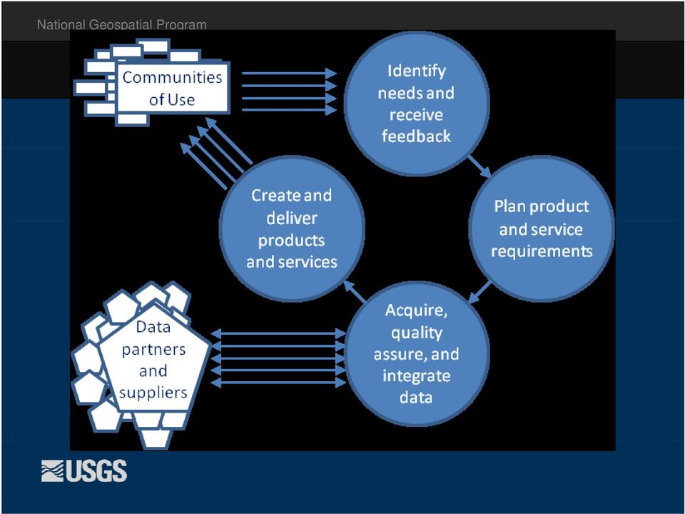
2 An Abridged History of USGS Topographic Mapping Temple Act authorized completion of national topographic survey and cooperative agreements with States National Map Accuracy Standards Issued Federal Geographic Data Committee Established EO established the NSDI The National Map Vision The National Map Customer Requirements Study Engage Users at TNM Conference Topographic Mapping begun in support of geologic mapping With Census Bureau, Completed hydro and trans DLGs for conterminous US 1 st Digital Elevation Model 1 st Digital Line Graph (DLG) 1 st Digital Orthophoto Once-over 24k Topographic mapping completed USGS and Microsoft Launch Terraserver seamless imagery viewing Lidar-derived data 1 st US Topo 24k Added to National Electronic map Elevation Dataset published 1 st Release of The With partners, Reach halfway National Map Viewer of USGS and Partner data Complete 1 st coverage of 24k National Hydrography Dataset mark of 3-year cycle of national coverage Of 55,000 US Topos USGS as PRODUCER USGS as FACILITATOR USGS as INTEGRATOR CENTRALIZED/FEDERAL DECENTRALIZED SYSTEMATIC, FOCUSED State partners contribute funds to USGS to complete mapping State partners contributed funds to USGS for digitizing USGS begins funding partners for data and infrastructure development Co-funding Engagin partnerships for Users core data themes Staff located in 4 mapping centers Mapping Liaisons Distributed on the Landscape Liaison in Every state Budget Reduction = No Backfills
 1 st Digital Orthophoto Once-over 24k Topographic mapping completed USGS and Microsoft Launch Terraserver seamless imagery viewing Lidar-derived data 1")
3 National USGS Geospatial as PRODUCER Program Centralized/Federal USGS as FACILITATOR Decentralized USGS as INTEGRATOR Systematic / Focused Mile estones/d Drivers Topographic mapping began in support of geologic mapping st Digital Elevation Model and 1 st Digital Line Graph (DLG) st Digital Orthophoto 1991 Once over topo coverage completed 1994 NSDI established 2001 The National Map Vision published 2003 The National Map Viewer of USGS and partner data released 2005 National Geospatial Program formed of mapping, FGDC and Geospatial One Stop 2008 The National Map Tactical Plan The National Map Customer Requirements Study 2011 National Geospatial Program Strategic Plan st The National Map Users Conference 2011 National Enhanced Elevation Assessment Part tner Role State partners contribute funds to USGS to complete mapping, digitize maps, collect imagery USGS begins funding partners for data and infrastructure development Focused partnerships for core data themes Staffin ng Staff located in 4 mapping centers Mapping Liaisons distributed on the Landscape, later concept of liaison for every state Reduction to liaison budget means no backfills and more multi-state liaisons

4 National Geospatial Program Mission Organize, maintain, publish, and disseminate the geospatial baseline of the Nation s topography through The National Map Foster a general understanding of broad geographic patterns, trends, and conditions through The National Atlas of the United States of America Data services Online maps: US Topo Data visualization Historic Map scans

5 National Geospatial Program Strategic Direction Sharpen focus on our topographic mapping mission High investment layers that define topo mapping: Elevation - Improve data quality and resolution nationally, pursue a national enhanced elevation data initiative Hydrography and watershed boundaries - Work with stewards to maintain data, enhance NHD to support users modeling and business needs, improve user tools Moderate investment - Geographic names: Fulfill the Public Law requirements of the Board on Geographic Names Maintenance investment - Imagery, transportation, boundaries, selected structures and land cover: For reference purposes, maintain coverage by obtaining data from other organizations and suppliers with a minimum investment

6 National Geospatial Program Strategic Direction Emphasis on meeting user needs Priority communities of use Water resources Natural resources conservation Geologic mapping Natural hazards

7 Prioritizing Communities of Use NGP Characteristic Topographic mapping mission User Community Characteristic Applications depend on elevation and hydrography data and products National program scope Applications are nationwide USGS, DOI missions Provide impact and benefit Earth sciences applications NGP products are critical to mission Serves many users Saves lives/property/$

8 NGP Strategic Plan in Action National Enhanced Elevation Assessment and 3D Elevation Program Document user needs for lidar and IFSAR, and the benefits they receive Identify approaches to a national program to meet these needs National Hydrography Dataset Enhancements Enhancements for modeling Dams, divergences, and water quantity and quality measurement stations Hydro Event Management (HEM) tool and training Assessing NHD Stewardship NGAC and potential Mapping Sciences Committee reviews Fault Mapping Landslide Inventory State use of HEM tool

9
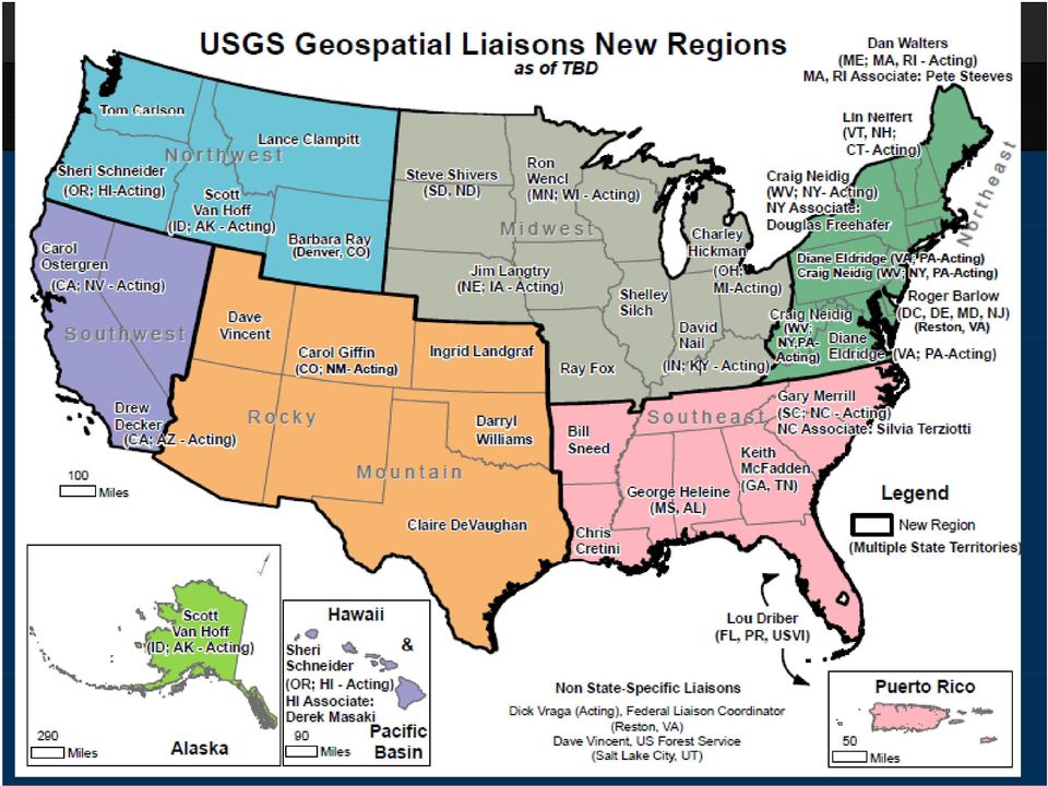
10 Strategic Direction for Partnerships Addition of user engagement activities at headquarters and din liaison i network Increase specialization In user communities In topographic mapping data themes Focus partnerships and data acquisition Focus partnerships in liaison network to elevation, NHD, and imagery Address both topographic and ancillary themes at headquarters

11 Community of Use Roles COU Coordinator Develop and manage overall user engagement strategy Organize and lead technical committee Determine user data that needs to be gathered National outreach Liaisons User engineer - provide technical support, document user problems, issues and suggestions Get to know the landscape, expand the contacts Staff technical committees, gather data, help to refine user needs Regional outreach

12 COU Activities Beginning Technical committees started in Jan., 2012 internal USGS users Plan to expand to include states (Geologic Mapping) Goal to collect user needs by Nov., 2012 for use in FY14 planning, also ongoing feedback Plans to expand externally by end of 2012 AWRA, AASG, others

13 Draft Liaison Specializations Partnerships and Coordination (Elevation, Imagery) Coordinate data acquisition/ stewardship and inventory partnerships p Serve as technical expert for partners and users on 3DEP, LiDAR, IfSAR, urban area imagery, NAIP Agreements Management NHD Engineer / Water Resources COU Liaison Coordinate and support NHD stewardship and applications Support users in applying NGP products and services to hydrologic applications, facilitate documentation of Water Resources user needs COU Liaison i for Geologic Mapping, Hazards and Natural Resources Conservation Support users in applying NGP products and services to COU- related applications, facilitate documentation of COU user needs

14
15 Liaison Functions Team PURPOSE - to refine liaison functions to maximize the effectiveness of the network in supporting and integrating NGP and Region goals MEMBERSHIP Liaisons Ostergren, Shivers Supervisors Holcomb, Jones (Weaver), Armstrong, Owens (DiNardo) NGP Product and Services Simley NGP Partnerships Aichele, Fuller, Lukas
 NGP Product and Services Simley NGP Partnerships")
16 Approach Review existing liaison definition - DONE Document current liaison functions - DONE Analyze goals and objectives and compare to current functions, define functions to de-emphasize, functions to grow IN PROGRESS Develop staffing plan recommendations NEXT p g p Goal to have new assignments made in Q1 of FY13

17 Changes Moving From 1 point of contact in the state to cover all facets of NGP products and services Liaisons are generalists Broad partnerships and coordination support User needs addressed on an ad hoc basis Moving Toward Multiple (~3) liaisons serve your state to cover all facets of NGP products and services More technical depth available to partners and users Partnerships and coordination support focused on topographic mapping Systematic approach to documenting and addressing user needs

18 Need State Support Flexibility as we work out the new structure Your feedback on what s working and what s not Help us to connect with the COU representatives in your state representatives in your state Communication

19 Questions & Discussion
Earth Data Science in The Era of Big Data and Compute
 Earth Data Science in The Era of Big Data and Compute E. Lynn Usery U.S. Geological Survey usery@usgs.gov http://cegis.usgs.gov U.S. Department of the Interior U.S. Geological Survey Board on Earth Sciences
Development of an Impervious-Surface Database for the Little Blackwater River Watershed, Dorchester County, Maryland
 Development of an Impervious-Surface Database for the Little Blackwater River Watershed, Dorchester County, Maryland By Lesley E. Milheim, John W. Jones, and Roger A. Barlow Open-File Report 2007 1308
The Delaware DataMIL A Pilot Project for The National Map. April 18, 2002 Delaware GIS Conference: Connecting Communities
 The Delaware DataMIL A Pilot Project for The National Map April 18, 2002 Delaware GIS Conference: Connecting Communities The DataMIL Team University of Delaware Christina Callahan, Research & Data Management
Standards for the Preparation of Digital Geospatial Metadata
 National Mapping Program Technical Instructions Standards for the Preparation of Digital Geospatial Metadata U.S. Department of the Interior U.S. Geological Survey National Mapping Division PREFACE On
State of North Dakota. GIS Program Strategic Plan 2015-2017
 State of North Dakota GIS Program Strategic Plan 2015-2017 Prepared By: Bob Nutsch GIS Coordinator Information Technology Department Approved By: North Dakota GIS Technical Committee Date of Publication:
NC Geographic Information Coordinating Council Acronym List - By Category
 NC Geographic Information Coordinating Council Acronym List - By Category Acronym Full Name GICC Committees and Working Groups A Team LGC GIS Advisory Team BGN NC Board on Geographic Names LGC Local Government
Indiana Office of Community and Rural Affairs. Disaster Recovery and Mitigation Planning Ft. Worth, Texas February 15, 2012
 Indiana Office of Community and Rural Affairs Disaster Recovery and Mitigation Planning Ft. Worth, Texas February 15, 2012 Floods Indiana s costliest hazard State ranks 5 th in annual median flood damages
The following was presented at DMT 14 (June 1-4, 2014, Newark, DE).
.") DMT 2014 The following was presented at DMT 14 (June 1-4, 2014, Newark, DE). The contents are provisional and will be superseded by a paper in the DMT 14 Proceedings. See also presentations and Proceedings
DMT 2014 The following was presented at DMT 14 (June 1-4, 2014, Newark, DE). The contents are provisional and will be superseded by a paper in the DMT 14 Proceedings. See also presentations and Proceedings
Creating the US Topo
 Creating the US Topo A Process Discussion National Geospatial Program Office National Geospatial Technical Operations Center Helmut Lestinsky Graphics Product Specialist MOD Project Manager U.S. Department
Can GIS Help You Manage Water Resources? Erika Boghici Texas Natural Resources Information Systems
 Can GIS Help You Manage Water Resources? Erika Boghici Texas Natural Resources Information Systems Hydrologic Information System Hydrologic Modeling Arc Hydro Geodatabase Arc Hydro Data Model: combination
Enterprise GIS Business Plan July 4, 2008
 Office for Information Resources GIS Services Enterprise GIS Business Plan July 4, 2008 VERSION 1.1 Table of Contents 1 Executive Summary... 3 2 Background... 6 2.1 Tennessee Base Mapping Program... 6
Table of Contents. Executive Summary...1. Statement of Purpose and Key Terms...3. Strategic Planning Approach and Methodology...6
 Table of Contents Executive Summary...1 Statement of Purpose and Key Terms...3 Strategic Planning Approach and Methodology...6 Current Snapshot of GIS in the Commonwealth...16 A Shared Vision of GIS in
Subactivity: Habitat Conservation Program Element: National Wetlands Inventory
 HABITAT CONSERVATION FY 29 BUDGET JUSTIFICATION Subactivity: Habitat Conservation Program Element: National Wetlands Inventory National Wetlands Inventory ($) FTE 27 4,7 2 28 Enacted 5,255 2 Fixed Costs
GIS Initiative: Developing an atmospheric data model for GIS. Olga Wilhelmi (ESIG), Jennifer Boehnert (RAP/ESIG) and Terri Betancourt (RAP)
, Jennifer Boehnert (RAP/ESIG) and Terri Betancourt (RAP)") GIS Initiative: Developing an atmospheric data model for GIS Olga Wilhelmi (ESIG), Jennifer Boehnert (RAP/ESIG) and Terri Betancourt (RAP) Unidata seminar August 30, 2004 Presentation Outline Overview
GIS Initiative: Developing an atmospheric data model for GIS Olga Wilhelmi (ESIG), Jennifer Boehnert (RAP/ESIG) and Terri Betancourt (RAP) Unidata seminar August 30, 2004 Presentation Outline Overview
DEVELOPING AN INUNDATION MAP STANDARD FOR THE U.S. ARMY CORPS OF ENGINEERS
 DEVELOPING AN INUNDATION MAP STANDARD FOR THE U.S. ARMY CORPS OF ENGINEERS Will Breitkreutz, Geographer, U.S. Army Corps of Engineers Kansas City District, Kansas City, Missouri, will.l.breitkreutz@usace.army.mil
APFO Data Provisioning and Services
 Who We Are APFO is the primary source of aerial imagery for the U.S. Department of Agriculture. Data Stewards for NAIP, and historical aerial photography collected for USDA dating back to 1955. Who We
Michigan Tech Research Institute Wetland Mitigation Site Suitability Tool
 Michigan Tech Research Institute Wetland Mitigation Site Suitability Tool Michigan Tech Research Institute s (MTRI) Wetland Mitigation Site Suitability Tool (WMSST) integrates data layers for eight biophysical
Strategic Activities to Support Sustainability of Canada s Geospatial Data Infrastructure
 Strategic Activities to Support Sustainability of Canada s Geospatial Data Infrastructure Paula McLeod Canada Centre for Mapping and Earth Observation United Nations 10 th Regional Cartographic Conference
Stream-Network Navigation in the U.S. Geological Survey StreamStats Web Application
 2009 International Conference on Advanced Geographic Information Systems & Web Services Stream-Network Navigation in the U.S. Geological Survey StreamStats Web Application Kernell G. Ries III, Peter A.
Pima Regional Remote Sensing Program
 Pima Regional Remote Sensing Program Activity Orthophoto GIS Mapping and Analysis Implementing Agency Pima Association of Governments (Tucson, Arizona area Metropolitan Planning Organization) Summary Through
CAPITAL REGION GIS SPATIAL DATA DEMONSTRATION PROJECT
 CAPITAL REGION GIS SPATIAL DATA DEMONSTRATION PROJECT DRAFT January 2013 Prepared by: O2 Planning + Design, Inc. The information contained in this document has been compiled by O2 Planning + Design Inc.
Business Plan for the. The Geospatial Platform. September 20, 2012 REDACTED
 Business Plan for the Geospatial Platform September 20, 2012 REDACTED The Geospatial Platform Federal Geographic Data Committee Geospatial Platform Business Plan, September 20, 2012 REDACTED 1 The Federal
Homeland Security Infrastructure Program HSIP Gold 2012 September 2012
 Homeland Security Infrastructure Program HSIP Gold 2012 September 2012 George Thomas, Chief, Content & Knowledge Management Division (PDC) IWG-Readiness, Response & Recovery (IWG-R3) George.J.Thomass@nga.mil,
Landsat Monitoring our Earth s Condition for over 40 years
 Landsat Monitoring our Earth s Condition for over 40 years Thomas Cecere Land Remote Sensing Program USGS ISPRS:Earth Observing Data and Tools for Health Studies Arlington, VA August 28, 2013 U.S. Department
2014-16 NSDI Strategic Plan
 2014-16 NSDI Strategic Plan FY 2015 Implementation Plan FGDC Coordination Group Actions (Discussion Draft 5-6-15) Federal Geographic Data Committee www.fgdc.gov STRATEGIC GOAL 1 DEVELOP CAPABILITIES FOR
Utah State General Records Retention Schedule SCHEDULE 1 GEOSPATIAL DATA SETS
 Utah State General Records Retention Schedule SCHEDULE 1 BIOTA RECORDS (Item 1-26) These are geospatial records that depict wildlife use areas in the state of Utah as determined by wildlife biologists
Issues and Challenges for Federal Geospatial Information
 Issues and Challenges for Federal Geospatial Information Peter Folger Specialist in Energy and Natural Resources Policy April 27, 2012 CRS Report for Congress Prepared for Members and Committees of Congress
Strategic Planning Process Map
 Advancing Statewide Spatial Data Infrastructures in Support of the National Spatial Data Infrastructure (NSDI) Strategic Planning Process Map For use by all Stakeholders in the Geospatial Community Produced
AUTOMATION OF FLOOD HAZARD MAPPING BY THE FEDERAL EMERGENCY MANAGEMENT AGENCY ABSTRACT INTRODUCTION
 AUTOMATION OF FLOOD HAZARD MAPPING BY THE FEDERAL EMERGENCY MANAGEMENT AGENCY Daniel M. Cotter Federal Emergency Management Agency Federal Insurance Administration Office of Risk Assessment 500 C Street,
A Method Using ArcMap to Create a Hydrologically conditioned Digital Elevation Model
 A Method Using ArcMap to Create a Hydrologically conditioned Digital Elevation Model High resolution topography derived from LiDAR data is becoming more readily available. This new data source of topography
Modernization Roadmap for the Geospatial Platform. Version 4.0 March 2011
 Modernization Roadmap for the Geospatial Platform Version 4.0 March 2011 US Department of the Interior Federal Geographic Data Committee Contents 1. FOREWORD... 1 2. PREAMBLE... 4 3. EXECUTIVE SUMMARY...
Cartographic and Geospatial Materials
 LIBRARY OF CONGRESS COLLECTIONS POLICY STATEMENTS ±² Collections Policy Statement Index Cartographic and Geospatial Materials This document consolidates and replaces the former Maps, Atlases, and Remote
Technology Trends In Geoinformation
 Technology Trends In Geoinformation Dato Prof. Sr Dr. Abdul Kadir Bin Taib Department of Survey and Mapping Malaysia (JUPEM) Email: drkadir@jupem.gov.my www.jupem.gov.my NGIS 2008 3 rd. National GIS Conference
UNITED STATES DEPARTMENT OF THE INTERIOR BUREAU OF LAND MANAGEMENT MANUAL TRANSMITTAL SHEET. 1283 Data Administration and Management (Public)
") Form 1221-2 (June 1969) Subject UNITED STATES DEPARTMENT OF THE INTERIOR BUREAU OF LAND MANAGEMENT MANUAL TRANSMITTAL SHEET 1283 Data Administration and Management (Public) Release 1-1742 Date 7/10/2012
Form 1221-2 (June 1969) Subject UNITED STATES DEPARTMENT OF THE INTERIOR BUREAU OF LAND MANAGEMENT MANUAL TRANSMITTAL SHEET 1283 Data Administration and Management (Public) Release 1-1742 Date 7/10/2012
Applying GIS in seismic hazard assessment and data integration for disaster management
 Applying GIS in seismic hazard assessment and data integration for disaster management Rumiana Vatseva, Dimcho Solakov, Emilia Tcherkezova, Stela Simeonova, Petya Trifonova National Institute of Geophysics,
Partitioning the Conterminous United States into Mapping Zones for Landsat TM Land Cover Mapping
 Partitioning the Conterminous United States into Mapping Zones for Landsat TM Land Cover Mapping Collin Homer Raytheon, EROS Data Center, Sioux Falls, South Dakota 605-594-2714 homer@usgs.gov Alisa Gallant
National Land Cover Database Visualization and Information Tool
 CDI SSF Category 3: Data and Information Assets National Land Cover Database Visualization and Information Tool Applicants/Principle Investigators(s): Collin Homer, USGS EROS, 47914 252 nd St, Sioux Falls,
Page Intentionally Left Blank
 Flood Map Modernization Mid-Course Adjustment March 30, 2006 Page Intentionally Left Blank Table of Contents Executive Summary... iii 1. Introduction...1 1.1. Purpose of Report...1 1.2. Background...1
DRAFT Map Modernization Plan for The State of Ohio. Prepared by The Ohio Department of Natural Resources Division of Water Columbus, Ohio
 DRAFT Map Modernization Plan for The State of Ohio Prepared by The Ohio Department of Natural Resources Division of Water Columbus, Ohio DRAFT Map Modernization State for Ohio DRAFT Ohio Map Modernization
ROLE OF THE MODELING, MAPPING, AND CONSEQUENCES PRODUCTION CENTER
 ROLE OF THE MODELING, MAPPING, AND CONSEQUENCES PRODUCTION CENTER Russ Wyckoff, P.E., CFM, MMC Modeling Lead, Tulsa District, USACE, Tulsa, Oklahoma, russell.wyckoff@usace.army.mil ABSTRACT: The goal of
COUNTRY REPORT GEOSPATIAL INFORMATION MANAGEMENT IN NEPAL
 COUNTRY REPORT ON GEOSPATIAL INFORMATION MANAGEMENT IN NEPAL Government of Nepal Ministry of Land Reform and Management SURVEY DEPARTMENT PO Box 9435 Min Bhavan, Kathmandu Nepal Tel : + 977 1 4622713 +
STATE OF NEVADA Department of Administration Division of Human Resource Management CLASS SPECIFICATION
 STATE OF NEVADA Department of Administration Division of Human Resource Management CLASS SPECIFICATION TITLE PHOTOGRAMMETRIST/CARTOGRAPHER V 39 6.102 PHOTOGRAMMETRIST/CARTOGRAPHER II 33 6.110 PHOTOGRAMMETRIST/CARTOGRAPHER
Remote Sensing, GPS and GIS Technique to Produce a Bathymetric Map
 Remote Sensing, GPS and GIS Technique to Produce a Bathymetric Map Mark Schnur EES 5053 Remote Sensing Fall 2007 University of Texas at San Antonio, Department of Earth and Environmental Science, San Antonio,
MSDI: Workflows, Software and Related Data Standards
 MSDI: Workflows, Software and Related Data Standards By Andy Hoggarth October 2009 Introduction Leveraging SDI principles for hydrographic operational efficiency French INFRAGEOS example (SHOM - Service
Oregon Strategic Plan for Geographic Information Management
 OGIC Oregon Geographic Information Council Oregon Strategic Plan for Geographic Information Management Oregon Geographic Information Council September 15, 2010 Table of Contents Page Executive Summary
National Geospatial Data Policy Procedure for Geospatial Metadata Management
 Issued by the EPA Chief Information Officer, Pursuant to Delegation 1-19, dated 07/07/2005 National Geospatial Data Policy Procedure for Geospatial Metadata Management 1. PURPOSE The purpose of the Procedure
The State of New Jersey. Fiscal Year 2004 Map Modernization Business Plan
 The State of New Jersey Fiscal Year 2004 Map Modernization Business Plan April 30, 2004 REGION II EXECUTIVE SUMMARY Introduction Historically, the State of New Jersey has taken a strong role in the development
CIESIN Columbia University
 Conference on Climate Change and Official Statistics Oslo, Norway, 14-16 April 2008 The Role of Spatial Data Infrastructure in Integrating Climate Change Information with a Focus on Monitoring Observed
A Geospatial Solution for Minimizing Risk. Pipeline Hazard Categorization
 A Geospatial Solution for Minimizing Risk Pipeline Hazard Categorization 1 Agenda 1. At stake: corporate value and reputation 2. Contributing Pipeline Segments: a building block for risk prioritization
Department of the Interior Open Data FY14 Plan
 Department of the Interior Open Data FY14 Plan November 30, 2013 Contents Overview Introduction DOI Open Data Objectives Transparency Governance and Culture Change Open Data Plan FY14 Quarterly Schedule
Business Plan for Orthoimagery in North Carolina
 Business Plan for Orthoimagery in North Carolina Statewide Mapping Advisory Committee Working Group for Orthophotography Planning October 2010 North Carolina Geographic Information Coordinating Council
Peninsular Florida Landscape Conservation Cooperative. Charter. Background
 Charter Background The Peninsular Florida Landscape Conservation Cooperative (Conservation Cooperative) is part of a national network of Landscape Conservation Cooperatives (LCCs). LCCs are applied conservation
Christopher Young Speaking notes for presentation to World Heritage UK Technical Workshop on WHS Management Plans and Systems, 25 th January, 2016
 WORLD HERITAGE UK TECHNICAL WORKSHOP, EDINBURGH, 25 TH JANUARY, 2016 DRAFT OUTLINE FOR CHRISTOPHER YOUNG S PRESENTATION CHANGES IN THE UNESCO OPERATIONAL GUIDELINES, AND OTHER CONVENTION RELATED ACTIVITY
Oregon Elevation Framework Implementation Team (E-FIT) Draft Charter and Bylaws 8/28/2014
 Draft Charter and Bylaws 8/28/2014") Oregon Elevation Framework Implementation Team (E-FIT) Draft Charter and Bylaws 8/28/2014 Adopted by OGIC, September 19, 2014 ARTICLE I. Name & Duration This Team, established by the State Framework Implementation
Oregon Elevation Framework Implementation Team (E-FIT) Draft Charter and Bylaws 8/28/2014 Adopted by OGIC, September 19, 2014 ARTICLE I. Name & Duration This Team, established by the State Framework Implementation
Making Geospatial Data Available and Accessible in Jamaica
 Making Geospatial Data Available and Accessible in Jamaica Presented by Cecille Blake, National GIS Coordinator Office of the Prime Minister, National Spatial Data Management Division 9 th UNRCC New York
Appendix J Online Questionnaire
 Appendix J Online Questionnaire In accordance with the Paperwork Reduction Act, this questionnaire was approved by the Office of Management and Budget (OMB). The OMB control number and expiration date
Center for Urban Ecology Strategic Plan
 January 2004 1 Center for Urban Ecology Strategic Plan Science and Service through Partnerships Mission The Center for Urban Ecology is an interdisciplinary team that provides scientific guidance, technical
Geospatial Information and Geographic Information Systems (GIS): Current Issues and Future Challenges
: Current Issues and Future Challenges") Geospatial Information and Geographic Information Systems (GIS): Current Issues and Future Challenges Peter Folger Specialist in Energy and Natural Resources Policy June 8, 2009 Congressional Research
Geospatial Information and Geographic Information Systems (GIS): Current Issues and Future Challenges Peter Folger Specialist in Energy and Natural Resources Policy June 8, 2009 Congressional Research
Geospatial Platform Update. Jerry Johnston National Geospatial Advisory Committee Meeting March 17, 2015
 Geospatial Platform Update Jerry Johnston National Geospatial Advisory Committee March 17, 2015 Accomplishments & Ongoing Activities (Dec. Feb.) Goal One: Shared Services GeoPlatform Service Desk Support
3. Data Availability for Habitat, Watershed, and Recreation Planning in Southern California
 DECEMBER 2004 3. Data Availability for Habitat, Watershed, and Recreation Planning in Southern California Christine S. Lam Hong Chen Christina Li John P. Wilson Acknowledgements: The authors are grateful
U.S. COMMERCIAL REMOTE SENSING POLICY. April 25, 2003 FACT SHEET
 U.S. COMMERCIAL REMOTE SENSING POLICY April 25, 2003 FACT SHEET The President authorized a new national policy on April 25, 2003 that establishes guidance and implementation actions for commercial remote
Oregon Framework Implementation Team March 09, 2004 BLM Snow Peak Conference room
 Oregon Framework Implementation Team March 09, 2004 BLM Snow Peak Conference room Present: Cy Smith, DAS/GEO; Ed Arabas, DAS/GEO; Gillien Duvall, DAS/GEO ; Scott Jackson, DOR; Marc Thomas, BLM; Paul Staub,
ALASKA GEOSPATIAL BUSINESS PLAN. Final, February 2012
 ALASKA GEOSPATIAL BUSINESS PLAN Final, February 2012 This page intentionally left blank Page 2 Business Plan Draft, V2.1 Contents Executive Summary 5 1 Introduction 9 1.1 Overview 9 1.2 Business Plan Unpacked
2013-2015. Milwaukee Metropolitan Sewerage District STRATEGIC PLAN
 Milwaukee Metropolitan Sewerage District STRATEGIC PLAN 2013-2015 The Strategic Plan identifies the District s strengths, weaknesses, opportunities, and threats, and provides direction and focus to help
S.B. NO. B7b JAN 2 7 2016
 S.B. NO. Bb JAN 0 A BILL FOR AN ACT THE SENATE TWENTY-EIGHTH LEGISLATURE, 0 STATE OF HAWAII RELATING TO STATEWIDE COMMUNITY PLAN. BE IT ENACTED BY THE LEGISLATURE OF THE STATE OF HAWAII: SECTION. The legislature
CDA Information Technology: Fiber To the Home
 C O E U R D A L E N E T R I B E I N F O R M A T I O N T E C H N O L O GY GIS Program Spring 2014 Volume 1, Issue 1 GIS Program plans for new imagery of Reservation Inside this issue: Fiber to Home 2 WWP
GIS User Guide. for the. County of Calaveras
 GIS User Guide for the County of Calaveras Written by Dave Pastizzo GIS Coordinator Calaveras County San Andreas, California August 2000 Table of Contents Introduction..1 The Vision.1 Roles and Responsibilities...1
The USGS Landsat Big Data Challenge
 The USGS Landsat Big Data Challenge Brian Sauer Engineering and Development USGS EROS bsauer@usgs.gov U.S. Department of the Interior U.S. Geological Survey USGS EROS and Landsat 2 Data Utility and Exploitation
National Geospatial Data Asset Management Plan
 National Geospatial Data Asset Management Plan Portfolio Management Implementation Plan for the OMB Circular A 16 Supplemental Guidance as it relates to OMB Circular A 16, Coordination of Geographic Information
Oregon GIS Program Leaders Meeting October 10, 2006 Department of Consumer and Business Services - Salem
 Oregon GIS Program Leaders Meeting October 10, 2006 Department of Consumer and Business Services - Salem Present: Rod Therriault, DOR; Phil McClellan, DOR; Gail Ewart, DAS/GEO; Joe Bernert, OED; Bob, OWRD;
WV County GIS Plan Template
 Monongalia County GIS Strategic Plan and WV County GIS Plan Template Final Report July 2004 Prepared by: Kurt Donaldson WV GIS Technical Center Department of Geology and Geography West Virginia University
USGS QUADRANGLES IN GOOGLE EARTH
 USGS QUADRANGLES IN GOOGLE EARTH By Thomas G. Davis 1, PhD, PE, PLS and Rollins Turner 2, PhD INTRODUCTION QUADS (http://www.metzgerwillard.us/quads/) is a web-based service for visualizing USGS quadrangle
Geographic Information Systems (GIS) - Water Management (U.S. Perspective) Sabine Grunwald 1
 - Water Management (U.S. Perspective) Sabine Grunwald 1") Geographic Information Systems (GIS) - Water Management (U.S. Perspective) Sabine Grunwald 1 1 Associate Professor & Distance Education Coordinator, Soil and Water Science Department, University of Florida,
Geographic Information Systems (GIS) - Water Management (U.S. Perspective) Sabine Grunwald 1 1 Associate Professor & Distance Education Coordinator, Soil and Water Science Department, University of Florida,
Next Generation Archives: The NC Geospatial Data Archiving Project
 Next Generation Archives: The NC Geospatial Data Archiving Project Jeff Essic North Carolina State University Libraries Zsolt Nagy North Carolina Center for Geographic Information and Analysis Coastal
Outreach and Communications Plan for the Geospatial Platform
 Outreach and Communications Plan for the Geospatial Platform Version 1.0 March 2011 US Department of the Interior Federal Geographic Data Committee Outreach and Communications Plan v1 2011 3 30 Outreach
A HYDROLOGIC NETWORK SUPPORTING SPATIALLY REFERENCED REGRESSION MODELING IN THE CHESAPEAKE BAY WATERSHED
 A HYDROLOGIC NETWORK SUPPORTING SPATIALLY REFERENCED REGRESSION MODELING IN THE CHESAPEAKE BAY WATERSHED JOHN W. BRAKEBILL 1* AND STEPHEN D. PRESTON 2 1 U.S. Geological Survey, Baltimore, MD, USA; 2 U.S.
Users/Historical Data Working Group Update to Coordination Group
 June 16, 2015 Coordination Group Meeting Users/Historical Data Working Group Update to Coordination Group Jacqueline Nolan Library of Congress Member, U/HDWG jnol@loc.gov Introduction The Users/Historical
Mapping Application for Resource Planning
 Mapping Application for Resource Planning Wyoming Association of Conservation Districts Cathy Rosenthal, WACD Nephi Cole, NRCS SuiteWater Concept Create an Internet application to support WACD Natural
GTM North Carolina Floodplain Mapping Program. RFQ 286-000023 Pre-Submittal Conference
 GTM North Carolina Floodplain Mapping Program RFQ 286-000023 Pre-Submittal Conference State Response / Strategies Strategy 1 - Establishment of a statewide program to acquire, process and disseminate current,
Qatar National Geospatial Infrastructure
 Qatar National Geospatial Infrastructure Since 1990 up to 2030 and beyond Mohammad Abd El-Wahab Hamouda GIS Consultant & Chairman of GIS Coordinators Group The Center for GIS Ministry of Municipality and
GIS Data Discovery Workshop
 Florida Division of Emergency Management 1 GIS Data Discovery Workshop Richard Butgereit GIS Administrator 850-413-9907 richard.butgereit@em.myflorida.com floridadisaster.org/gis Critical Facilities Inventory
2010 2015 AIA Strategic Plan 1
 2010 2015 Strategic Plan The American Institute of Architects Driving positive change through the power of design AIA THE AMERICAN INSTITUTE OF ARCHITECTS 2010 2015 AIA Strategic Plan 1 2010 2015 AIA Strategic
1.0 Business Case. 2.0 Current Circumstances. 3.0 Proposed Solution
 Proposal Plan for Geographic Information System (GIS) Capability for the Department of State Human Resources Knowledge Center - C. Christian (IRM/BPC/eDiP), R. Harford (HR/EX/SDD), B. Van Pay and D. Smith
California Department of Fish and Game (Wildlife) GIS Data and Services
 GIS Data and Services") California Department of Fish and Game (Wildlife) GIS Data and Services http://www.dfg.ca.gov Steve Goldman GIS Manager Biogeographic Data Branch 1. GIS Data 2. Web Applications 3. Map Services GIS Data:
California Department of Fish and Game (Wildlife) GIS Data and Services http://www.dfg.ca.gov Steve Goldman GIS Manager Biogeographic Data Branch 1. GIS Data 2. Web Applications 3. Map Services GIS Data:
OCCUPATIONAL GROUP: Information Technology. CLASS FAMILY: Geographic Information Systems CLASS FAMILY DESCRIPTION:
 OCCUPATIONAL GROUP: Information Technology CLASS FAMILY: Geographic Information Systems CLASS FAMILY DESCRIPTION: This family of positions is a blend which includes those at a Computer Technology level
Army National Guard: Common Installation Picture. Chris Argentieri Brooks Smith
 1 Army National Guard: Common Installation Picture Chris Argentieri Brooks Smith 2 Agenda Introduction Goals/Purpose of Common Installation Picture program History of CIP processes Integration with the
Geographic Information Systems
 Jan Coyne, William C. Bell, Mary Maureen Brown, Chad Rupert, and James Nolan Geographic Information Systems A geographic information system (GIS) combines database management and analysis functions with
NATIONAL CLIMATE CHANGE & WILDLIFE SCIENCE CENTER & CLIMATE SCIENCE CENTERS DATA MANAGEMENT PLAN GUIDANCE
 NATIONAL CLIMATE CHANGE & WILDLIFE SCIENCE CENTER & CLIMATE SCIENCE CENTERS DATA MANAGEMENT PLAN GUIDANCE Prepared by: NCCWSC/CSC Data Management Working Group US Geological Survey February 26, 2013 Version
MAPPS BLM Update. Sun River, Oregon, July 2015
 MAPPS BLM Update Sun River, Oregon, July 2015 Mary Hartel Chief Cadastral Surveyor, Oregon and Washington Branch of Geographic Sciences, Oregon State Office Bureau of Land Management s Mission to manage
LARGE PROJECT MANAGEMENT AND OVERSIGHT
 LARGE PROJECT MANAGEMENT AND OVERSIGHT Report to The Senate Subcommittee on Transportation, Treasury and General Government The House Subcommittee on Transportation, Treasury and Independent Agencies Prepared
2014-16 NSDI Strategic Plan
 2014-16 NSDI Strategic Plan FY 2015 Status Report December 2015 Federal Geographic Data Committee www.fgdc.gov Contents Overview... 2 Strategic Goal 1 Develop Capabilities for National Shared Services...
Geospatial Information for disaster risk reduction and natural resources management. Rolando Ocampo Alcántar
 Geospatial Information for disaster risk reduction and natural resources management Rolando Ocampo Alcántar Content Background Geospatial Information for Disaster Management Risk Atlas Information Exchange
Data Integration Strategies
 Data Integration Strategies International Delta Roundtable November 2007 U.S. Department of the Interior U.S. Geological Survey USGS Data Integration Vision and Drivers USGS Science Strategy: Science in
USGS StreamStats Web Application for Kentucky
 USGS StreamStats Web Application for Kentucky Implementation of selected low- and mean-flow estimating equations Gary Martin, Hydrologist Project Chief U.S. Geological Survey, Kentucky Water Science Center
Principles and Practices of Data Integration
 Data Integration Data integration is the process of combining data of different themes, content, scale or spatial extent, projections, acquisition methods, formats, schema, or even levels of uncertainty,
Alluvial Fan Mapping and Risk Assessment
 Alluvial Fan Mapping and Risk Assessment Army Corps of Engineers: Webinar Week 12:30PM (MST) 08.21.2013 Silver Jacket Conference Idaho Department of Water Resources Boise, Idaho Overview PROJECT OVERVIEW
Risk MAP Project Coordination Meeting: Burlington County, NJ. FEMA REGION II May 8, 2013 Westampton, New Jersey
 Risk MAP Project Coordination Meeting: Burlington County, NJ FEMA REGION II May 8, 2013 Westampton, New Jersey Agenda Introductions Purpose of this Meeting Risk MAP Program Overview Anticipated Project
Canadian Geospatial Data Infrastructure Vision, Mission and Roadmap - The Way Forward
 CANADIAN GEOSPATIAL DATA INFRASTRUCTURE CANADIAN GEOSPATIAL DATA INFRASTRUCTURE INFORMATION PRODUCT 28e Canadian Geospatial Data Infrastructure Vision, Mission and Roadmap - The Way Forward GeoConnections
An Initial Assessment of the Impacts of Sea Level Rise to the California Coast
 An Initial Assessment of the Impacts of Sea Level Rise to the California Coast Photo by D. Revell 2/23/08 California Coastal Records Project Dr. David Revell and Matt Heberger, P.E. Dr. Peter Gleick, Bob
Landslide Briefing to City Council April 28, 2014
 Landslide Briefing to City Council April 28, 2014 OEM: Barb Graff DPD: Susan Chang, P.E. SPU: Nancy Ahern SDOT: Lawrence Eichhorn SFD: Chief A. D. Vickery Landslide Planning and Response History of landslides