A lithostratigraphy of Weichselian glacial and interstadial deposits in Denmark
|
|
|
- Barrie Dean
- 8 years ago
- Views:
Transcription
1 A lithostratigraphy of Weichselian glacial and interstadial deposits in Denmark MICHAEL HOUMARK-NIELSEN Houmark-Nielsen, M : A lithostratigraphy of Weichselian glacial and interstadial deposits in Denmark. Bulletin of the Geological Society of Denmark, Vol. 46, pp Copenhagen. A lithostratigraphic model of Weichselian tills and inter-till deposits in Denmark is erected. Deposits comprise 1) Till, other diamicts and meltwater sediments deposited during glaciated stadials and 2) Interstadial and stadial fluvial, lacustrine and marine sediments deposited under climatic ameliorations and ice free conditions. Stratigraphic successions are correlated using lithological and palaeoecological evidence and they are linked to the marine sequences in northern Denmark named the Skærumhede series. Three stadials with one or more glaciation events succeeding Eemian interglacial conditions have been recognized. The oldest, Ristinge stadial, is most likely from the early Middle Weichselian situated between the Odderade and Moershoofd interstadials. It comprises The Ristinge, Ringshøj and Lovns tills of Baltic origin is found in the eastern and central parts of Denmark. The post-hengelo, Klintholm stadial from the late Middle Weichselian, is represented by the Baltic Klintholm till found in the easternmost part of the country and possibly the Esrum diamicton in the buried Esrum valley belong to this stadial. The post-sandnes interstadial, Late Weichselian Jylland stadial comprise the Kattegat Till of Norwegian provenance is found in northern Denmark. It is followed by the Mid Danish, Grenå, Fårup, Store Klinthøj, Himmerland tills of middle Swedish origin, and deposited by the ice-stream which reached the Main Stationary Line from northeasterly directions. The East Jylland and North Sjælland tills of respectively Baltic and Swedish provenance overlie the former tills in eastern Denmark. These are succeeded by the Bælthav Till of Baltic origin which is confined to the Danish islands. Late glacial deposits from the Bølling-Allerød oscillation comprises the upper boundary for Weichselian deposits. The compilation of the stratigraphic model serves the purpose of combining and bringing forward regional and local stratigraphic studies from the past decades and to set up a frame-work for dating the age and duration individual glaciation events and interstadials. Key words: Lithostratigraphy, Weichselian, Denmark, relative glaciation chronology. M. Houmark-Nielsen, Geological Institute, University of Copenhagen, DK-1350 Copenhagen, Denmark. 18 January Over the past two decades, several lithostratigraphic models of Weichselian till and inter-till deposits have been published. In these partly incompatible models, formal, as well as informal, stratigraphic units have been erected in different regions of the country, and related to phases of glaciation and interstadial events. Data from northern and middle Jylland, have been compiled primarily by Ditlefsen (1991), Kronborg (1984), Kronborg, Bender, Bjerre, Friborg, Jacobsen, Kristiansen, Rasmussen, Sørensen & Larsen (1990) and Larsen & Kronborg (1994), while regions in the central and eastern part of Denmark have been described by Berthelsen (1979), Houmark-Nielsen (1981, 1987, 1989) and Sjørring (1983). These authors generally agree that the younger till units, previously named the NE-till and succeeded by theyoung Baltic till (Andersen 1933, Berthelsen 1978), belong to the Upper Weichselian maximum glaciation and that Houmark-Nielsen: A Danish Weichselian lithostratigraphy 101
 Till, other diamicts and meltwater sediments deposited during glaciated stadials and 2) Interstadial and stadial fluvial, lacustrine and marine sediments deposited under climatic")
2 Fig. 1: Key and locality map of names mentioned in the text. MSL= Main Stationary Line, E= East Jylland ice-border line, B= Bælthav ice margin. they reached the Main Stationary Line (MSL in Fig. 1) and the East Jylland ice-border line (E in Fig. 1), respectively. The stratigraphic position and lateral distribution of older, yet Weichselian till units of Baltic and Norwegian provenance have, on the other hand, been much debated, and opposing views on their implication for the glaciation-chronology have been published (Houmark-Nielsen 1981, Kronborg 1984, Petersen 1984, Sjørring 1983). During the Weichselian, glaciers originating in the Scandinavian highlands and the Baltic depression invaded Denmark from northerly, northeasterly and southeasterly directions. Erratics respectively from southern Norway, middle Sweden and the Baltic, were incorporated in the ice which eventually deposited successive till and outwash sediment successions. During climatic ameliorations between ice advances, interstadial deposits containing arctic to boreo-arctic and sub-arctic to northern temperate marine and terrestrial faunas and floras were laid down, sometimes under periglacial conditions. The primary objective for compiling the present model is to link stratigraphies from key regions in Denmark, in addition, contributions from other published and unpublished sources are incorporated to extend and reinforce the model. It provides a lithostratigraphic synthesis of glacigenic deposits, and with terrestrial as well as marine interstadial beds, from the larger part of Denmark (Fig. 1). The stratigraphic model, though independent of absolute ages, will allow the establishment of a relative chronology of Weichselian glaciations. It will serve as the framework for age-dating of individual glacial and interstadial events based on previously published data and a new set of radiocarbon and luminescence dates (Houmark-Nielsen unpublished). Methods A general consensus exists on the methodology used in studies of stratigraphic sections exposing Quaternary deposits, so that the description of tills and the establishing of stratigraphic models by most authors follows common principles defined and applied by 102 Bulletin of the Geological Society of Denmark
.")
3 Berthelsen (1973, 1978), Larsen, Jørgensen & Priisholm (1977), Larsen, Liboriussen & Villumsen (1972), Sjørring (1977) and Sørensen & Nielsen (1978). Correlation of till units is achieved by the matching of stratigraphical position and lithological characters, and emphasis is placed on those features (primarily deduced from till fabric analyses) which indicate the direction of local glacier movement. This is then combined into regional ice flow patterns using provenancedependent compositional features ( Houmark-Nielsen 1987, Kronborg et al. 1990). In connection with the latter, authors working in the two main regions mentioned above have chosen different clast sizes to characterise petrographic properties of till units, which makes uncertainty of correlation when major regions are compared. Often comparison is only possible using the calcium carbonate-free components, because many till units in northern and central Jylland are impoverishing or lack limestones due to dissolution. The boundary relationships of till units, especially glaciotectonic unconformities, may serve as markers in the stratigraphic record. This adds high-ranking information on the direction of local glacier movement, as outlined in the principles of kineto-stratigraphy by Berthelsen (1978) and modified and integrated into lithostratigraphic classification by Houmark-Nielsen (1987). Correlation between the two main regions in Denmark, and between individual sites, is further inhibited because much data are only available from summary-articles, some originating in unpublished Ph.D. and M. Sc. theses and review-papers (Ditlefsen 1991, Larsen & Kronborg 1994, Petersen, Rasmussen & Pedersen 1992, Petersen & Kronborg, 1991, Rasmussen & Petersen 1980). To justify stratigraphic separation of individual till units the palaeoecological characters of inter-till, stadial and interstadial deposits serve as marker beds, which on biological evidence can be linked to the subdivision of the Weichselian in northwest Europe and the oxygen isotope deep sea record (e.g. Behre 1989). Requirements for a stratigraphic model A lithostratigraphic model needs well-defined boundaries. Consequently, Weichselian deposits are constrained between interglacial strata, whose palaeontological characteristics formally define their stratigraphic status. Holocene sediments, and the preceding late glacial Bølling and Allerød interstadial de- Fig. 2: Stratigraphy and palaeoecological interpretation of the Skærumhede I and II (approx. 50 to 150 m below surface) and Nørre Lyngby boring 2 (isotope substages 5e- 5b) through the Skærumhede series. Compiled from Jessen, Milthers, Nordmann, Hartz & Hesselbo (1910), Bahnson et al. (1973), Kristensen et al. (1998), Lykke-Andersen & Knudsen (1991). Houmark-Nielsen: A Danish Weichselian lithostratigraphy 103
.")
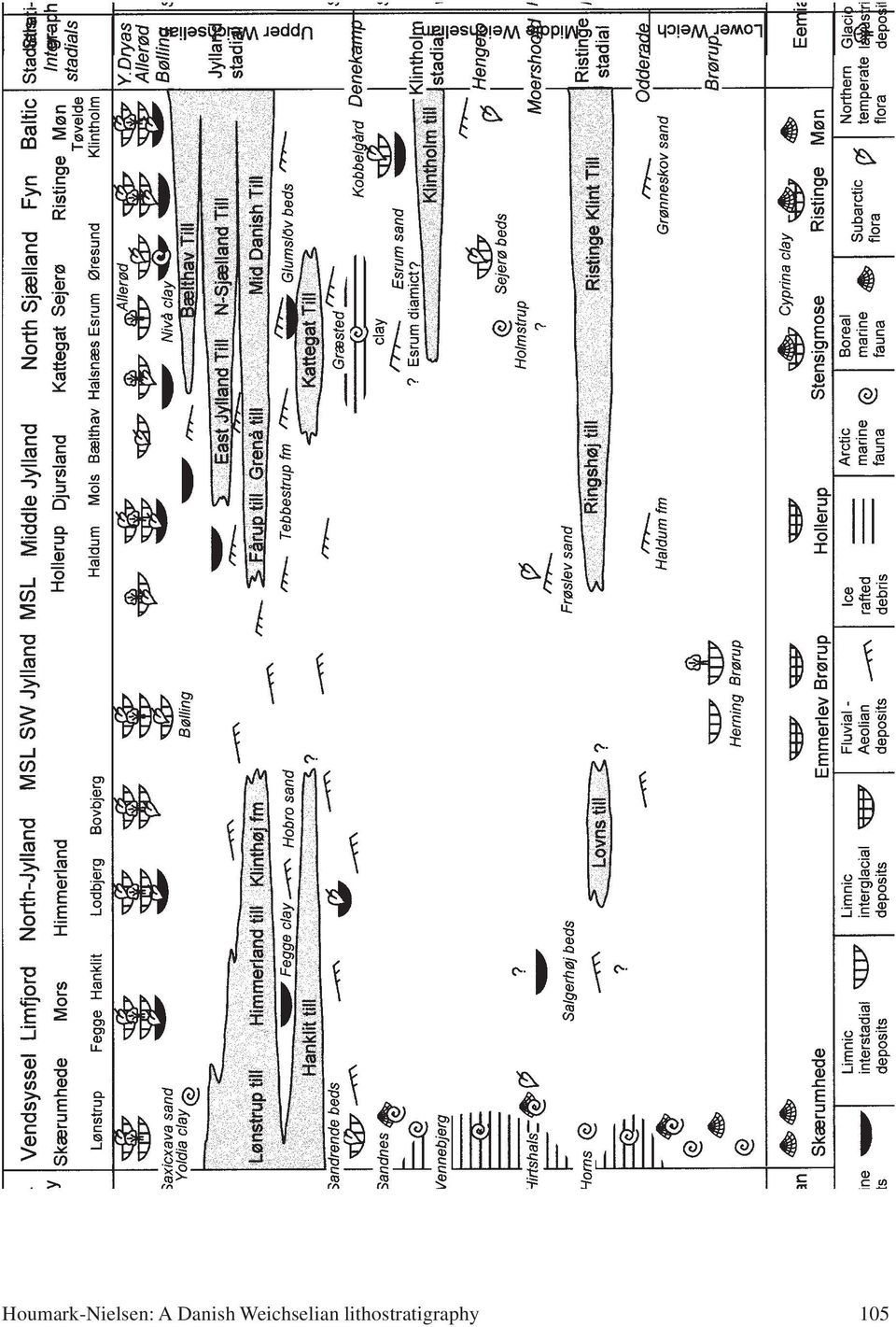
4 posits, (characterised by arctic to boreo-arctic marine conditions and subarctic park tundra and northern temperate forest environments) post-date Weichselian glacigenic sediments, and are found scattered over larger parts of the country (Hansen 1965). Deposits of the Eemian interglacial, which are characterised by boreolusitanian marine conditions and temperate deciduous forest environments, pre-date the Weichselian, and are primarily listed from a number of key sections in the eastern part of the country (Houmark-Nielsen 1987, 1989). Northern Jylland (excluding Vendsyssel and Kattegat) in particular, lacks recorded Eemian strata, and against this background Ditlefsen (1991) addressed the important question of whether possible pre-late Weichselian glaciations are recorded in borings from the marine Skærumhede Series (Fig. 2). In Vendsyssel and Kattegat, Late Weichselian glacigenic sediments are missing from several borings penetrating the Portlandia arctica zone of the Skærumhede series (Nielsen & Konradi 1990, Seidenkrantz 1993, Seidenkrantz & Knudsen 1993). However, evidence from other borings and especially open sections, clearly indicates that glaciers from southern Norway and western Sweden crossed Vendsyssel and other parts of northern Jylland during the Late Weichselian Maximum (Lykke-Andersen 1981, Fredericia 1989, Pedersen 1996, Richardt 1996, Sadolin, Pedersen & Pedersen 1997). Borings through marine successions which contain deposits of the upper Middle Weichselian Sandnes interstadial or older do not include glacial sediments, and it is assumed that they indicate more or less continuous Eemian to Late Weichselian marine deposition (Lykke-Andersen & Knudsen 1991). Coarse-grained debris found in the Skærumhede II boring, along with glacially abraded clasts and foraminifera indicating boreo-arctic conditions (Fig. 2), is interpreted as ice-rafted debris (Bahnson, Petersen, Konradi & Knudsen 1974). The resolution of the marine stratigraphy is, however, variable, and many borings show hiatuses and intervals of non-marine deposition (Knudsen 1994, Lykke-Andersen 1987). This indicates that even though the absence of till in the marine Skærumhede sequence does not exclude ice cover, the lack of such evidence from numerous borings speaks against any pre-late Weichselian glaciation in northern Denmark. Lithostratigraphy of Weichselian till beds in Denmark A lithostratigrapic model of Weichselian tills and inter-till deposits in Denmark is presented in Figure 3. The model is laid out as a combined, north-south and west-east oriented cross section that correlates the stratigraphy of the marine Skærumhede series and northern Jylland (left), with the remaining part of Jylland and the eastern part of the country including Fyn, Sjælland and the Baltic coast (right). South-western Jylland beyond the Main Stationary Line (MSL) is presented in the middle section. The model presents a stratigraphical framework which divides the Weichselian sedimentary successions into a Lower Weichselian consisting of non-glacial sediments, a Middle Weichselian characterized by the first appearance of tills, and an Upper Weichselian representing the maximum glaciation (Jylland stadial, Houmark-Nielsen 1989). The Lower Weichselian Periglacial deposits, which comprise fluvial and aeolian sand, separate the Eemian from the lowermost Weichselian till at Ristinge Klint: The White sand (Andersen 1933, Hamberg 1989, Sjørring, Nielsen, Frederiksen, Hegner, Hyde, Jensen, Mogensen & Vortisch 1982). According to Hamberg (1989) and Friis & Larsen (1975) these deposits have a regional distribution around southern Fyn and will be referred to as the Grønneskov sand. Solifluction deposits and fluvial sand containing redeposited Eemian marine shells are found in a similar stratigraphic position on Møn (Fig. 4, unit 3, Houmark-Nielsen 1994), while fluvial sand (Haldum formation) overlying limnic Eemian deposits occurs at Hollerup, middle Jylland (Kronborg et al. 1990). Similar deposits, possibly including the Brørup Interstadial, overlie Eemian peat bogs at Emmerlev Klev in southwestern Jylland, (Christensen 1998). Interstadial deposits are present above limnic Eemian at the classical sites at Solsø, Brørup and Herning (Jessen & Milthers 1928, Andersen 1961). At these localities, no tills occur above the Eemian, which suggests that western Jylland never experienced glaciation during the Weichselian as discussed by Andersen (1961) and Jessen, Milthers & Nordmann (1918), even though the opposite view is held by Petersen & Kronborg (1991). Kristensen, Knudsen, Lykke-Andersen, Nørmark, Peacock & Sinnott (1998) has suggested that the decline in arctic foraminifera in what is equivalent to the upper Turritella terebra zone, indicates the presence of the Brørup interstade in the marine record of Vendsyssel (Fig. 2). This suggestion is supported by other data from Kristensen et al s multidiciplinary study from the boring at Nørre Lyngby, Lønstrup Klint. Fig. 3. Lithostratigraphic model of Weichselian tills and inter-till deposits in Denmark. 104 Bulletin of the Geological Society of Denmark
.")
5 Houmark-Nielsen: A Danish Weichselian lithostratigraphy 105
6 Fig. 4. Section logs with indication of stratigraphic units in cliff exposures around Klintholm and Kobbelgård, eastern Møn. Unit 1: Late Saalian till, 2: Marine Eemian, 3: Solifluction and periglacial deposits, 4: Ristinge Klint Till, 5: Periglacial deposits, 6: Klintholm till, 7: Lower Kobbelgård beds, 8: Upper Kobbelgård beds, 9: Bælthav Till. (From Houmark-Nielsen 1988). The Middle Weichselian In northern Jylland, Ditlefsen (1991) has reported a till (Sundsøre till) possibly underlying sandy deposits eqvivlalent to the Haldum formation. In several localities the till rests on Saalian till or is separated from Upper Weichselian tills by the Hobro sand. The post-eemian stratigraphic position of this till, which has a northerly and northeasterly provenance, cannot, however, be demonstrated at the type sections in the Melbjerg Hoved area, and its lower Weichselian age is suggested merely by the presence of an overlying till (Lovns till), which it self is correlated with the Ringshøj till and Ristinge Klint Till of Baltic provenance in central and eastern Denmark (Ditlefsen 1991, Kronborg et al. 1990, Larsen & Kronborg 1994). Ditlefsen (1991) admitted the uncertain stratigraphic position of the Sundsøre till and even allowed an Upper Weichselian position for subunits of the till found in the western Limjord area. Its correlation with the Upper Weichselian, Kattegat Till, as proposed by Larsen & Kronborg (1994), would indicate, according to the present model, deposition during the Jylland stadial. Ristinge Klint Till and Ringshøj till Ristinge Klint Till overlies Grønneskov sand at Ristinge, and constitutes the oldest Weichselian till in eastern Denmark (Houmark-Nielsen 1987, 1994, Fig. 4, unit 4). Its Baltic provenance is evident from large numbers of erratics from the Baltic region (especially Palaeozoic limestones) and fabric analyses indicate local ice-flow patterns from southeasterly directions. Besides its clear stratigraphic position at key sections, a post-eemian age is also indicated by the presence of reworked marine fossils from the Cyprina Clay, whose affiliation to the Eemian was demonstrated by Nordmann (1928). The Frøslev sand carries evidence for the growth of Juniperus between the Odderade and Moershoofd interstadials on an alluvial fan in southern Jylland (Kolstrup & Havemann 1984). Moreover, these authors suggest that the fan was deposited in connection with an ice-stream prior to the Upper Weichselian glaciations and consequently sanwished between the above mentioned interstadials. Petersen & Kronborg (1991) connected the fan with the Baltic ice- advance which deposited the Ristinge Klint Till. Post-Eemian outwash sediments, which correlate with the ones from Frøslev, are found widespread elsewhere 106 Bulletin of the Geological Society of Denmark
 has reported a till (Sundsøre till) possibly underlying sandy deposits eqvivlalent to the Haldum formation.")
7 Fig. 5: Schematic cross-section through the Øresund region (from Houmark-Nielsen, 1997). Compiled from Adrielsson (1984); Lagerlund (1987); Schuldt (1981); Konradi (1992); DGU (1989); Houmark-Nielsen (1987). ED: Esrum diamicton, ES: Esrum sand, Gä: Gärdslöv beds, AL: Allarp till, GL: Græsted clay, U: Uranienborg sand, Å: Ålabodana till, K: Kattegat Till, G: Glumslöv sand, M: Mid Danish Till and North Sjælland Till, V: Västernäs till, D: Dalby till, B: Bælthav Till, L: Laebrink till, N & L: Nivå & Lomma clay, Ø: Øresund diamicton. in the region between Frøslev and Ristinge, where they are related to the melting of the glacier that deposited the Ristinge Klint Till (Houmark-Nielsen 1987). Thus, the fan sediments constitutes parts of a regionally confined outwash plain in south Jylland and western Fyn. Kronborg et al. (1990) and Pedersen & Petersen (1997) correlated Ristinge Klint Till with Ringshøj till from middle Jylland and Djursland. Here, its Baltic provenance is less clear, but the stratigraphic position and regional ice-flow patterns deduced from glaciotectonic deformation and fabric analyses support such a correlation. Ditlefsen (1991) correlate Lovns till from Himmerland with the above mentioned till units. At the type section, Ristinge Klint Till is overlain by the so-called yellow (glaciofluvial) sand (Sjørring et al. 1982), and in Himmerland, and parts of central Jylland, Lovns till and Ringshøj till are overlain by the Hobro sand, which separates them from the Upper Weichselian Himmerland till (Ditlefsen 1991). The high arctic Horns stadial in the Skærumhede series (Fig. 2) is bracketed by marine deposits with boreo-arctic foraminiferal faunas and abundant icerafted debris dominated by crystalline rocks of the Precambrian basement below and by Cretaceous and Tertiary limestone and flint above the Horns stadial (Bahnson et al. 1974, Lykke-Andersen & Knudsen 1991). Lykke-Andersen & Knudsen (1991) correlated the subsequent Hirtshals interstadial with the terrestrial, middle European Moershoofd interstadial, which in Vendsyssel is followed by the arctic Vennebjerg stadial (Fig. 2).The ice rafted debris indicates the presence of glaciers along the fringes of the Skærumhede sea during the Middle Weichselian (Petersen 1984, Houmark-Nielsen 1989). The petrographic composition suggests that glaciers of northerly and easterly provenance calved into the sea before the Horns stadial and that glaciers of southerly provenance was the source of debris during the Hirtshals interstadial and Vennebjerg stadial. At Holmstrup, western Sjælland, marine mud with a boreo-arctic fauna overlying till of Baltic origin has been suggested to correlate with the Hirtshals interstadial (Petersen & Buch 1974, Petersen 1984). In the buried Esrum valley of northern Sjælland, the Esrum diamicton is overlain by the Esrum sand (Fig. 5). The diamicton contains redeposited Quaternary foraminifera resembling those of zone IV in the Portlandia artica zone, suggesting to Schuldt (1981) deposition during the Middle Weichselian, probably from an ice- Houmark-Nielsen: A Danish Weichselian lithostratigraphy 107

8 Fig. 6: Composite stratigraphic logs from central Denmark. M: Mud, S: Sand, G: Gravel: T: Till, thickness interval 5 metres. Arrows indicate palaeocurrent directions. Log 1: Mols and Djursland, log2 North Samsø, log 3: South Samsø and adjacent islands, log 4: Sejerø, log 5: Vejrhøj area, log 6: Sjællands Odde, log 7: Halsnæs, log 8: Hornsherred and Roskilde. Kl: Klintholm till, K: Kattegat Till, G: Glumslöv sand, H: Himmelev formation, T: Tebbestrup formation, M: Mid Danish Till, Gr: Grenå till, Ti: Tirstrup formation, He: Hedeland formation, E: Eastjylland Till, N: North Sjælland Till, B: Bælthav Till. (Modified from Houmark-Nielsen 1987, Jacobsen 1985, Nielsen 1987, Pedersen & Petersen 1997). stream of northerly provenance, which occurred after the Hirtshals interstadial. However, the northerly provenance of the diamicton has not been documented neither has its glacigenetic origin as till been proven. Klintholm till According to Houmark-Nielsen (1994), the Ristinge Klint Till and Klintholm till at Møn are separated by fluvial and lacustrine sand and mud deposited under periglacial conditions (Fig. 4, unit 5). On Sejerø, Klintholm till overlies lacustrine deposits containing remnants of a sparse and tree-less flora which is correlated with the Hengelo interstadial (Houmark-Nielsen & Kolstrup 1981). Klintholm till is characterised by redeposited Eemian marine fossils, and its clast composition is of Baltic provenance and clast-fabrics indicate local ice-movements from southeasterly directions (Houmark-Nielsen 1987, Nielsen 1987). In the Halsnæs area Klintholm till is overlain by the Mid Danish Till (Nielsen 1987) but on Møn, is overlain by the lacustrine muds and the diamicts of the Kobbelgård beds (Fig. 4, unit 7 & 8). These contain remnants of a subarctic flora somewhat similar to that of the Gärdslöv beds found in the Esrum-Alnarp valley in Skåne. Significantly, the clast composition of the diamicts of unit 8 closely resembles that of the Allarp till in Skåne, which is characterised by an abundance of Palaeozoic shale and limestone clasts (Houmark-Nielsen 1994). According to Berglund & Lagerlund (1981) and Lagerlund (1987) the Allarp till is the lowermost of a succession of Late Weichselian tills post-dating the Gärdslöv beds in Skåne (Fig. 5). In eastern Jylland, Baltic tills overlain by the Kattegat Till is correlated with the late Saalian Lillebælt Till (Houmark-Nielsen 1987). However, in cases where its pre-eemian position is not clear they may correspond to Klintholm till or Ristinge Klint Till (Fig. 6, log 1, unit L). Kattegat Till In north Sjælland, parts of the Esrum-Alnarp valley are filled with the Esrum sand and the Græsted clay (Fig. 5). The former is probably younger than the Hirtshals interstadial in the Skærumhede series (Schuldt, 1981), while the foraminiferal faunas from the Græsted clay suggests that the clay is of glaciomarine origin and in comparison with the fauna of the Skærumhede series, it belongs to the upper part of the 108 Bulletin of the Geological Society of Denmark
.")
9 Middle Weichselian (Konradi 1992). Its glacioaqueous heritage is supported by the inconsistent descriptions in geological maps ranging from till over diamicton to mud with single pebbles (DGU 1989). The fact that the Græsted clay is confined within the buried valley at consistent levels also speaks against glaciation during deposition. In accordance with Adrielsson (1984, pers. com. 1999) the Esrum sand is correlated with the Uranienborg sand and the Gärdslöv beds, while the Græsted clay constitutes a lateral facies change to glaciomarine sediments. Studies of open sections and well-site data from northern Sjælland, indicate that Kattegat till is separated from the Græsted clay by sandy deposits. Consequently, Kattegat Till is equivalent to Ålabodarna till and Smedstorp till in Skåne, which most probably is younger than the Gärdslöv beds and Kobbelgård beds (Adrielsson 1984, Lagerlund 1987, Houmark-Nielsen 1994). Fabric analyses, Norwegian erratics, and a re-worked marine fauna from the Skærumhede series or the Græsted clay indicate northerly source for the Kattegat Till (Houmark- Nielsen1987). After deposition in the Halsnæs area (northern Sjælland) it locally underwent glaciotectonic deformation from the north (Sjørring 1974, Jensen 1977). Klintholm till is also similarly glaciotectonised in that region, which suggests that it is older than Kattegat Till, however, both tills have not been observed in the same exposure (Houmark-Nielsen 1987). Kattegat Till is correlated with till C from Rugård (Kronborg & Knudsen 1985) and till of Norwegian origin on Djursland, which is overlain by the Tebbestrup formation (Pedersen & Petersen 1997). Both the Kattegat Till, and the glaciotectonic unconformity (indicating deformation from the north) are overlain by a muddy and sandy succession, Glumslöv beds (Adrielsson 1984), which generally show evidence of northward flowing palaeocurrents in central Denmark, whereas the glaciofluvial Himmelev formation represents proximal outwash deposits found in Hornsherred and in the Roskilde area (Figs 5 & 6). Fig. 7: Stratigraphy and depositional environments in Lønstrup Klint, Vendsyssel. (Modified from Sadolin et al. 1997). Upper Weichselian tills in northern Jylland The boreo-arctic Sandnes interstadial in the Skærumhede series (Figs 2 & 7) is correlated with the Upper Pleniglacial Denekamp interstadial (Lykke-Andersen & Knudsen 1991). In Vendsyssel, the marine deposits are succeeded by lacustrine and fluvial-deltaic sand and mud (Sandrende beds, Fig. 7). Their sedimentological features have been described by Sadolin et al. (1997), and they contain remnants of a subarctic flora comparable to that of the Kobbelgård beds (Houmark- Nielsen, Bennike & Björck 1996), and the beds are strongly glaciotectonised from northerly directions (Jessen 1936, Sadolin et al. 1997). Tills with Norwegian erratics and fabrics, suggesting ice movement from northerly directions, are found strongly glaciotectonised in the western Limfjord area (Ditlefsen 1991, Gry 1979, Klint & Pedersen 1995, Pedersen 1996). These tills, including the Hanklit till and the uppermost tills which are present in the glaciotectonically deformed beds in the cliffs at Skærbæk and Fegge (Mors) described by Gry (1979), Jensen (1992) and Pedersen (1996), may constitute one till unit overlying the glaciofluvial and glaciolacustrine part of the lower glacigenic group in Hanklit (Klint & Pedersen 1995; Salgerhøj beds of the present model). Similar deposits occur on the adjacent island of Fur, and in Himmerland, while the upper boundary of the tills is formed by the Fegge clay, which is correlated with Tebbestrup formation (Ditlefsen 1991). Houmark-Nielsen: A Danish Weichselian lithostratigraphy 109

10 The middle till in the prominent Bovbjerg section is correlated by Pedersen et al. (1988) with the till complex of the Store Klinthøj formation from Himmerland (Rasmussen & Petersen 1980, 1984). Larsen & Kronborg (1994) suggests that the middle till of Bovbjerg is an independent unit of northerly derivation and that it constitutes an early stage in the development of the Main Stationary Line. This till may correlate with the lower part of the Store Klinthøj formation. Even though the stratigraphic position of these Norwegian tills is uncertain, and their post-sandnes interstadial age is not stratigraphically constrained, the present model suggests correlation with the Kattegat Till. In central Jylland, the Tebbestrup formation overlies Kattegat Till, while tills of northerly provenance are overlain by the Hobro sand in Himmerland (Ditlefsen 1991, Larsen & Kronborg 1994, Pedersen & Petersen 1997). The Mid Danish Till Overlying the above mentioned glaciolacustrine and glaciofluvial deposits, the Mid Danish and its equivalents is found in the whole of the country inside the Main Stationary Line (Fig. 1). Mid Danish Till is described from eastern Denmark, and is characterised by fabric and glaciotectonic unconformities indicating ice-flow from northeasterly directions and erratics from middle Sweden (Houmark-Nielsen 1987). In northern Sjælland, it is overlain by North Sjælland Till and it corresponds to Dalby till (with clast material transported from the northeast) and Västernäs till in Skåne (Houmark-Nielsen 1997, Lagerlund 1987), Grenå till from Djursland (Pedersen & Pedersen 1997), Fårup till from central Jylland (Kronborg et al. 1990), Store Klinthøj till and Himmerland till from northern Jylland (Pedersen et al. 1988, Ditlefsen 1991). Lønstrup till which unconformably overlies the Sandrende beds at Lønstrup and the upper till at Lodbjerg, (Fredericia1989, Houmark-Nielsen et al. 1996, Jessen 1936, Richardt pers. comm. 1998, Sadolin et al. 1997, Sjørring 1989) probably correlates with the Mid Danish Till. At the latter locality, the till is overlain by late glacial lacustrine deposits (Qvistgaard pers. comm. 1998) and in Vendsyssel, the youngest till is covered by a marine succession (Younger Yoldia clay Saxicava sand, Fig. 7) which is overlain by freshwater deposits of the Allerød - Younger Dryas succession in Lønstrup (Jessen, 1936). The East Jylland Till and the North Sjælland Till East Jylland Till is separated from the Mid Danish Till by glaciofluvial deposits (cf. Tirstrup member on Mols, Fig. 6) and it is characterised by fabrics and glaciotectonic unconformities indicating ice-flow from southeasterly directions and it is bounded by the East Jylland ice-border line (Houmark-Nielsen 1987). East Jylland Till corresponds to the Ebeltoft till (Pedersen & Petersen 1997) and the Højvang till in middle Jylland (Kronborg et al. 1990). Its clast content is of Baltic origin and in eastern Denmark it is laterally replaced by North Sjælland Till which show evidence of ice-movement from easterly directions and is characterised by a low content of Baltic clasts. This correlation was suggested by Houmark-Nielsen (1981) and it is a modification of a later proposal (Houmark- Nielsen 1987). The till in Hornsherred and around Roskilde is bracketed by glaciofluvial deposits (Hedeland formation, Jacobsen 1985) and overlain by the Bælthav Till (Fig. 6). The Bælthav Till Bælthav Till is characterised by large numbers of Baltic erratics and indicators of ice-movement from generally southeasterly directions. Its distribution is restricted to the central and eastern part of the country (Houmark-Nielsen 1987), and it corresponds to the upper Baltic facies of Dalby Till and Laebrink till in Skåne (Fig. 5). In large parts of the country, Mid Danish Till, East Jylland Till, Bælthav Till and its equivalents are overlain by isolated occurrences of sandur deposits. Late glacial glaciolacustrine clays frequently overlie the tills of the Jylland stadial (Hansen 1940, 1965). In the Øresund region (Fig. 5), the late glacial Nivå and Lomma clays are overlain by the subaqueous and ice-rafted Øresund diamicton (Lagerlund & Houmark-Nielsen1993). The late glacial clays and sand eventually grade upward into organic rich mud and gyttja of the Bølling and Allerød interstadial Discussion In the present model (Fig. 3) glacigenic deposits in Denmark are younger than the Brørup and Odderade interstadials. The marine records from Vendsyssel and Kattegat strongly suggests that conditions for till deposition were first attained during the high-arctic Horns stadial at the beginning of the Middle Weichselian (Fig. 2). The model does not predict glaciations from the Scandinavian highlands before the Upper Weichselian in northern Jylland, first of all due to the lack of glacigenic sediments in the Skærumhede series. The Salgerhøj beds and their equivalents in northern Jylland suggest deglaciation in northern Jylland, but their Middle Weichselian stratigraphic position cannot be established despite claims by Ditlefsen (1991), neither is it unclear whether the sediments represent glaciation directly from the Scandinavian highlands or through the Baltic depression. This indicates along 110 Bulletin of the Geological Society of Denmark

11 with the ambiguous stratigraphic position of the Sundsøre till that a possibly Lower or Middle Weichselian position for this till difficult to retain. Although currently published knowledge is insufficient to establish its stratigraphic status, the Sundsøre till probably comprises till of Saalian age (those parts underlying the Haldum sand), where as other subunits may be confined to the Upper Weichselian as indicated by Ditlefsen (1991) and correlated with the Kattegat Till as proposed by Larsen & Kronborg (1994). Thus, the term Sundsøre till can not be sustained until a clear definition of its stratigraphic position can be erected from type sections. The clearest evidence for Middle Weichselian glaciations is seen along cliffs in southeastern Denmark (Fig. 4). The Old Baltic till, which was placed between the Eemian and NE-till of the Upper Weichselian by Andersen (1933) and Berthelsen (1979), was formally defined as the Ristinge Klint Till by Houmark-Nielsen (1987). Further evidence from Møn indicate two Baltic tills at this rather wide stratigraphic level, the uppermost of which is termed Klintholm till in the present model. The terrestrial record indicates that the tills are separated by the Moershoofd and Helgelo interstadials. Their respective ice-streams probably both had access to calving in the Skærumhede Sea, and the stratigraphic position of ice-rafted debris in the Skærumhede series suggests correlation with the Horns and Vennebjerg stadials respectively. The two tills are both found in the southeastern parts of the country but the Ristinge Klint Till can be traced westwards to southern Jylland. Because only one Baltic till of the same stratigraphic position is found in central Jylland, it is an open question which of the two that correlates with Ringshøj till. The present study has not been able to solve this problem and therefore the correlation with Ristinge Klilnt Till is based on the proposal of Kronborg et al. (1990) linking the Haldum formation to the advance of the ice-sheet that deposited the Ringshøj till. Ditlefsen (1991) correlated Lovns till with Ringshøj till. However, in a number of sections, where the Lovns till overlies the Sundsøre till, correlation with Ringshøj till is based on fabric analyses alone. At the key section at Melbjerghoved, Lovns till overlies a glaciotectonic unconformity indicating deformation from the NNW (Rasmussen & Petersen 1980, Larsen & Kronborg 1994). According to Houmark-Nielsen (1980) and Skibsted (1990), the till at Melbjerghoved carries Norwegian and Skagerrak erratics and has fine-gravel properties comparable to those of Drenthe type tills of the Saalian. Similarly clast fabric analyses do not support the ice-flow directions from the southeast, as reported by Ditlefsen (1991). Thus, the Baltic provenance of the Lovns till is questionable, and since clast fabrics are ambiguous, there are few localities in Himmerland and the Limfjord region where the stratigraphic evidence of Lovns till being equivalent with Ringshøj till is present. The stratigraphic position and genesis of the Esrum diamicton is not clear. Its postulated post Hirtshals interstadial age is based on a redeposited foraminiferal assemblage which could originate from any section of the arctic part of the Skærumhede series and its northern or Baltic provenance is unproven. The stratigraphic relation to the Ristinge and Klintholm tills are unknown, however, a Middle Weichselian position is proposed in the present model because it is situated beneath the Esrum sand and the Græsted clay. The stratigraphic relationship between the Ristinge Klint, Klintholm and Kattegat tills is not clearly defined. Interpretation of well data from northern Sjælland indicates that the Esrum sand and Græsted clay are present in the deeper parts of the Esrum valley, where they overlie the Esrum diamicton. It is suggested herein that the valley was filled with fluvial and glaciomarine sediments during the Middle Weichselian, before deposition of Kattegat Till, which from evidence in Skåne, is most probably the oldest of several Upper Weichselian tills recognised on both sides of Øresund. In the Halsnæs region indirect stratigraphic evidence suggests deformation of the Klintholm till by the ice-sheet which deposited the Kattegat Till. Thus, in the present model any Middle Weichselian Baltic till is regarded older than Kattegat Till. The distribution of Kattegat Till in northern Jylland is ambiguous. It could correlate with the till at Lønstrup that overlies the Sandnes interstadial beds in Figure 7, however, Fredericia (1989) suggests that this till is equivalent to the Mid Danish Till. Kattegat Till may correspond to tills in the Limfjord region that overlie the Salgerhøj beds, and in turn are overlain by the Fegge clay and the Hobro sand. But its southern extension is uncertain. Whether it occurs near the Main Stationary Line in the cliff site at Bovbjerg remains unsolved, although the middle till at Bovbjerg has been suggested to relate to this Upper Weichselian satatioary state (Larsen & Kronborg 1994) and is suggested to correlate with the ice-stream which deposited the Kattegat Till (Pedersen et al. 1988). The Upper Weichelian stratigraphic position and spatial distribution of the Mid Danish Till and its equivalents is agreed by most stratigraphers, just as the distribution and position of the overlying East Jylland Till is confirmed herein (Houmark-Nielsen 1987, Larsen & Kronborg 1994). The North Sjælland Till is sandwiched between the Mid Danish and Bælthav Till and Figure 3 follows the proposal of Houmark-Nielsen (1981), where it was suggested that it corresponds to, and is laterally replaced by, the East Jylland Till west of Halsnæs in the Bælthav region. This re-evaluation does not contradict the stratigraphic position proposed by Houmark-Nielsen (1987), but it does have implications for the interpretation of glacier behaviour and chronology of ice streams during the Late Weichselian. Houmark-Nielsen: A Danish Weichselian lithostratigraphy 111

12 Weichselian glaciation chronology in Denmark Because Denmark is situated along the fringes of consecutive Scandinavian ice-sheets, glacier advances reached the country as a response to patterns of growth and decay of the ice-sheet in more proximal settings sensitive to regional climatic changes. Houmark- Nielsen (1987) suggested that the course of glaciations across Denmark seemed to follow a general flowpattern in which northerly advances, originating in southern Norway, were replaced by northeasterly advances crossing southwestern Sweden and culminating in southeasterly advances through the Baltic depression. These cyclic glacial phases, with clockwise changes in direction of ice advances, was explained by the eastward drift of the central ice-dome, combined with surging of marginal domes as proposed by Lagerlund (1980). In the stratigraphic scheme of Figure 3, the presence of three stadials during the Weichselian is proposed, which tentatively is correlated with the Horns, Vennebjerg and Jylland stadials recorded in northern Jylland (Figs 2 & 7). The glaciation behaviour did not necessarily develop into full three-fold cycles, which indicates that any of the three ice-advances may not have had the strength or volume to reach Denmark. The first cycle could possibly have led to icerafting in the Skærumhede Sea by calving glaciers from the Scandinavian highlands followed by a Baltic ice-stream which deposited the Ristinge Klint and Ringshøj tills in the beginning of the Middle Weichselian. Apparently, the second cycle involved only Baltic glaciation in Denmark, which led to deposition of Klintholm till in the later part of the Middle Weichselian. However, glacial activity along the Norwegian and Swedish coast may have accompanied this Baltic ice as registered by ice-rafted debris in the Vennebjerg stadial of the Skærumhede series (Houmark-Nielsen 1989). The third cycle occurred in the Upper Weichselian, during the Jylland stadial and led to deposition of the Kattegat, Mid Danish, Eastjylland and North Sjælland and Bælthav Tills. Ice-free intervals between glacial cycles resulted in periglacial and interstadial environments which were characterised by mainly subarctic vegetation and boreo-arctic marine conditions. Acknowledgements Christian Kronborg (University of Aarhus), Stig Schack Pedersen and Kaj Strand Petersen (GEUS) is thanked for critical and beneficial discussions on the Weichselian till stratigraphy during the last decade. The referees Karen Luise Knudsen (University of Aarhus) and Lena Adrielsson (University of Lund) are thanked for critical and beneficial comments on the manuscript. Richardt Dingle (Univ. of Copenhagen) kindly improved the English language in major parts of the manuscript. René Madsen and Britta Munch gave most figures their finish. Dansk sammendrag I dette arbejde opstilles en litostratigrafisk model for till-sedimenter fra Weichsel istiden I Danmark. De enkelte tillenheder (tidl. morænebænke) er kendetegnet ved af deres stratigrafiske position og litologi, der kan omfatte karakteristisk stenindhold, omlejrede fossiler og retningselementer, som f. eks. stentorienteringer og skurestriber. Istektoniske deformationsstrukturer, der ofte ses ved basis af tills, eller som giver vidnesbyrd om isoverskridelse, hvor ingen till er til stede, udgør vigtige grænser for de enkelte stratigrafiske enheder. Smeltevandsdannelser og interstadiale hav-, sø-, flod- eller vindaflejringer, hvori der ofte findes rester af en arktisk-, subarktisk- eller boralpræget flora og fauna mellemlejrer de enkelte tills. Disse giver oplysninger om aflejringsmiljøerne under isfrie forhold mellem de forskellige isfremstød og aflejringerne kan ofte korreleres med den nordvesteuropæiske Weichselstratigrafi på baggrund af biologiske vidnesbyrd. Den her opstillede model, der er et forsøg på at præsentere en samlet stratigrafi for det meste af Danmark, bygger på korrelation mellem regionale stratigrafier, hvoraf ikke alle er offentliggjort i videnskabelige tidsskrifter endsige publiceret overhovedet. Sammenstillingen af regionale eller lokale stratigrafier, der i nogle tilfælde tilsyneladende er i modstrid med hinanden, giver mulighed for at opbygge en relativ isstrømskronologi for sidste istid. Modellen er sammenholdt med stratigrafiske og palæoøkologiske karaktertræk fra Skærumhede serien i Vendsyssel og Kattegat, idet denne hovedsageligt marine lagfølge er en af de stratigrafiske hjørnestene i det danske Senpleistocæn. Weichselistiden omfatter i føgle modellen tre stadialer, dvs. kuldeperioder hvor det skandinaviske isskjold bredet sig ud over Danmark, hhv. fra Sydnorge, Mellemsverige eller Østersøen. Det ældste stadial: Ristinge stadial er sandsynligvis fra tidlig Mellem Weichsel og omfatter Ristinge Klint Till, Ringshøj till og Lovns till afsat af en isstrøm fra Østersøen. Det midterste stadial er repræsenteret af Klintholm till, afsat af en baltisk is engang i Mellem Weichsel. Jylland stadialet fandt sted i Sen Weichsel og omfatter Kattegat Till afsat af en isstrøm fra Sydnorge efterfulgt af den Midt Danske Till, Grenå till, Fårup till, Store Klinthøj till, Himmerland till og Lønstrup till afsat under hovednedisningen af en isstrøm fra Mellemsverige. Østjylland Till, Ebeltoft till, Højvang till og Nord Sjælland Till aflejredes under det Østjy- 112 Bulletin of the Geological Society of Denmark

13 ske isfremstød mens Bælthav Till aflejredes af en isstrøm, der fra Østersølavningen trængte ind over det østlige Danmark. References Adrielsson, L. 1984: Weichselian lithostratigraphy and glacial environments in the Ven-Glumslöv area, southern Sweden. Lundqua Thesis 16, 120 pp. Andersen, S.A. 1933: Det danske Landskabs Historie. Danmarks Geologi I almenfatteligt omrids København: Levin & Munksgaard. Andersen, S.Th. 1961: Vegetation and its Environment in Denmark in the Early Weichselian Glacial (Last Glacial). Danmarks geologiske Undersøgelse II rk 61, 175 pp. Bahnson, H., Petersen, K.S., Konradi, P.B. & Knudsen, K.L. 1974: Stratigraphy of Quaternary deposits in the Skærumhede II boring: lithology, molluscs and foraminifera. Danmarks geolgiske Undersøgelse, Årbog 1973, Behre, K.E. 1989: Biostratigraphy of the last glacial period in Europe. Quaternary Science Reviews 8, Berglund, B.E. & Lagerlund, E. 1981: Eemian and Weichselian stratigraphy in South Sweden. Boreas 10, Berthelsen, A. 1973: Weichselian ice advances and drift successions in Denmark. Bulletin of the Geological Institute, University of Uppsala 5, Berthelsen, A. 1978: The methodology of kineto-stratigraphy as applied to glacial Geology. Bulletin of the Geological Society of Denmark 27, Special Issue, Berthelsen, A.1979: Contrasting views on the Weichselian glaciation and deglaciation of Denmark. Boreas 8, Christensen, H.H. 1998: Periglacial sediments in an Eemian-Weichselian succession at Emmerlev Klev, southwestern Jutland, Denmark. Palaeogeography, Palaeoclimatology, Palaeoecology 138, DGU 1989: Geologisk Basisdatakort 1514 I, 1514 II, 1514 IV. Danmarks Geologiske Undersøgelse, Boredataafdelingen. Ditlefsen, C. 1991: Luminescence Dating of Danish Quaternary Sediments. 116 pp. Unpublished Ph.D. thesis, Institute of Earth Sciences, University of Aarhus. Fredericia, J. 1989: Den hydrogeologiske kortlægning af Nordjyllands Amtskommune. Danmarks Geologiske Undersøgelse, Intern rapport 22, 231 pp. Friis, H. & Larsen, G. 1975: Tungmineralanalytisk bidrag til forståelsen af dannelsesforholdede for det sydfynske hvide sand (Kvartær). Dansk geologisk Forening. Årsskrift for 1974, Gry, H. 1979: Beskrivelse til Geologisk Kort over Danmark, Kortbladet Løgstør. Danmarks Geologiske Undersøgelse, Serie 1, 26, 58 pp. Hamberg, L. 1989: The Weichselian white quarts sand deposits at Grønneskov and the Ristinge Klint section: An example of periglacial aeolian sand sheet sediments. Excursion Guide to the Quaternary Geology of the southwestern part of Denmark. Danmarks Geologiske Undersøgelse, Intern Rapport 16, appendix 4, 5 pp. Hansen, S. 1940: Varvighed I danske og skaanske senglaciale Aflejringer. Danmarks geologiske Undersøgelse II rk 63, pp. Hansen, S. 1965: The Quaternary of Denmark. In Rankama, K. (ed.) The Geologic Systems: The Quaternary 1, 90 pp. New York, London, Sydney: Ineterscience Houmark-Nielsen, M. 1980: Glacialstratigrafi på kortbladet Viborg. Rapport over feltstudier og laboratorie analyser. Kvartærgeologisk Afdeling, Danmarks geologiske Undersøgelse. Unpublished report, 12 pp. Houmark-Nielsen, M. 1981: Glacialstratigrafi i Danmark øst for Hovedopholdslinien. Dansk geologisk Forening. Årsskrift for 1980, Houmark-Nielsen, M. 1987: Pleistocene stratigraphy and glacial history of the central part of Denmark. Bulletin of the Geological Society of Denmark 36, Houmark-Nielsen, M. 1988: Nyt om sidste istid. Klintholm, et nyt kvartærgeologisk nøgleprofil i Østdanmark. Varv 4, Houmark-Nielsen, M. 1989: The last interglacial-glacial cycle in Denmark. Quaternary International 3/4, Houmark-Nielsen, M. 1994: Late Pleistocene stratigraphy, glaciation chronology and Middle Weichselian environmental history from Klintholm, Møn, Denmark. Bulletin ofthe Geological Society of Denmark 41, Houmark-Nielsen, M. 1997: Mellem- og Sen Weichsel udvikling I Øresundsområdet. Abstract Geosymposium, 2pp. Det Naturvidenskabelige Fakultet, Københavns Universitet & Matematisk-Naturvetenskapliga Fakulteten, Lunds Universitet. Houmark-Nielsen, M. & Kolstrup, E. 1981: A radiocarbon dated Weichselian sequence from Sejerø, Denmark. Geologiska Föreningens Stockholm Förhandlingar 103, Houmark-Nielsen, M., Bennike, O. & Björck, S. 1996: Terrestrial biotas and environmentalchanges during the late Middle Weichselian in north Jylland, Denmark. Bulletin of the Geological Society of Denmark 43, Jacobsen, E.M. 1985: En råstofgeologisk kortlægning omkring Roskilde. Dansk geologiskforening, Årsskrift for 1984, Jensen, K.E.S.K. 1992: En geologisk undersøgelse af et glacialtektonisk disloceret randmorænestrøg ved Hanklit, Nordmors. Unpublished M s -thesis, Geological Institute, Univeristy of Copenhagen, 154 pp. Jensen, V. 1977: Store Karlsminde Klint, materialer og strukturer. Dansk geologisk Forening, Årsskrift for 1976, Jessen, A. 1936: Vendsyssels geologi. Danmarks geologiske Undersøgelse V rk 2, 195 pp. Jessen, A., Milthers, V., Hartz, N. & Hesselbo, A. 1910: En boring gennem de kvartære Lag ved Skærumhede. Danmarks geologiske Undersøgelse II rk 25, 175 pp. Jessen, A., Milthers, V. Nordmann, V. 1918: Brørup- Mosernes Lejringsforhold. Danmarks geologiske Undersøgelse IV rk. 9, 44 pp. Jessen, A. & Milthers, V. 1928: Stratigraphical and Paleontological Studies of Interglacial Fresh-water Deposits in Jutland and Northwest Germany. Danmarks geologiske Undersøgelse II rk 48, 380 pp. Klint, K.E.S. & Pedersen, S.A.S. 1995: The Hanklit glaciotectonic thrust fault complex, Mors, Denmark. Danmarks Geologiske Undersøgelse, Serie A 35, 30 pp. Knudsen, K.L. 1994: The marine Quaternary in Denmark: a review of new evidence from glacial-interglacial stud- Houmark-Nielsen: A Danish Weichselian lithostratigraphy 113

14 ies. Bulletin of the Geological Society of Denmark 41, Kolstrup, E. & Havemann, K. 1984: Weichselian Juniperus on the Frøslev alluvial fan (Denmark). Bulletin of the Geological Society of Denmark 32, Konradi, P.B. 1992: Marine kvartære aflejringer I Esrumdalen. Dansk geologisk Forening, Årsskrift for , Kristensen, P,. Knudsen, K.L., Lykke-Andersen, H., Nørmark, E. Peacock, J.D. & Sinnott, A. 1998: Interglacial and glacial climate oscillations in a marine shelf sequence from northern Denmark a multidiciplinary study. Quaternary Science Reviews 17, Kronborg, C. 1984: Glacialstratigrafien I Øst- og Midtjylland. 259 pp. Unpublished Ph. D. thesis, Geologisk Institut, Aarhus Universitet. Kronborg, C. & Knudsen, K.L. 1985: Om kvartæret I Rugård: En foreløbig undersøgelse. Dansk geologisk Forening, Årsskrift for 1984, Kronborg, C., Bender, H., Bjerre, R., Friborg, R., Jacobsen, H.O., Kristiansen, L., Rasmussen, P. Sørensen, P.R. & Larsen, G. 1990: Glacial stratigraphy of East and Central Jutland. Boreas 19, Lagerlund, E. 1987: An alternative Weichselian glaciation model with reference to the glacial history of Skåne. Boreas 16, Lagerlund, E. & Houmark-Nielsen, M. 1993: Timing and pattern of the last deglaciation in the Kattegat region, southwest Scandinavia. Boreas 22, Larsen, G., Liboriussen, J & Villumsen, A. 1972: Kvartærgeologiske undersøgelser på kortbladet Randers. Dansk geologisk Forening, Årsskrift for 1971, Larsen, G., Jørgensen, F.H. & Priisholm, S. 1977: The stratigraphy, structure and origin of glacial deposits in the Randers area, Eastern Jutland. Danmarks Geologiske Undersøgelse II rk 111, 36 pp. Larsen, G. & Kronborg, C. 1994: Det mellemste Jylland, En beskrivelse af områder af national geologisk interesse. 272 pp. Brenderup: Geografforlaget. Lykke-Andersen, A-L. 1981: En ny C-14 datering fra Ældre Yoldialer i Hirtshals kystklint. Dansk geologisk Forening, Årsskrift for 1980, 1 5. Lykke-Andersen, A-L. 1987: A Saalian, Eemian and Weichselian marine sequence at Nørre Lyngby, Vendsyssel, Denmark. Boreas 16, Lykke-Andersen, A-L. & Knudsen, K.L. 1991: Saalian, Eemian, and Weichselian in the Vendsyssel-Kattegat Region, Denmark. Striae 34, Nielsen, J.B. 1987: Kvartærstratigrafiske observationer langs østsiden af Roskilde Fjord. Dansk geologisk Forening, Årsskrift for 1986, Nielsen, P.E. & Konradi, P.B. 1990: Seismic Stratigraphy and Foraminifera in Late Quaternary Deposits, Southern Kattegat, Denmark. Striae 29, Nordmann, V. 1928: La position stratigraphique des dépôts d Eem. Danmarks geologiske Undersøgelse II rk 47, 81 pp. Pedersen, S.A.S. 1996: Progressive glaciotectonic deformation in Weichselian and Palaeogene deposits at Feggeklit, northern Denmark. Bulletin of the Geological Society of Denmark, 42, Pedersen, S.A.S., Petersen, K.S. & Rasmussen, L.Aa. 1988: Observations on glaciodynamic structures at the Main Stationary Line in western Jutland, Denmark. In Croot, D. (ed) Glaciotectonics: Forms and processes, Rotterdam: Balkema. Pedersen, S.A.S. & Petersen, K.S. 1997: Djurslands Geologi. Danmarks og Grønlands Geologiske Undersøgelse, 96 pp. Brenderup: Geografforlaget. Petersen, K.S. 1984: Stratigraphical position of Weichselian Tills in Denmark. In Köngisson, L-K, (ed.) Ten Years of Nordic Till Research. Striae 20, Petersen, K.S. & Buch, A. 1974: Dislocated tills with Paleogene and Pleistocene marine beds. Danmarks geologiske Undersøgelse, Årbog 1973, Petersen, K.S. & Kronborg, C. 1991: Late Pleistocene history of the inland glaciation in Denmark. In Frenzel, B. (ed.) Klimagechichtliche Probleme der letzen Jahre. Paläoklimaforschung 1, Petersen, K.S., Rasmussen, L.Aa. & Pedersen, S.A.S. 1992: Geologisk kort over Danmark. Kortbladet 1115 III Ulfborg. Danmarks Geologiske Undersøgelse, Kortserie 28. Rasmussen, L.Aa. & Petersen, K.S. 1980: Resultater fra DGU s genoptagne kvartærgeologiske kortlægning. Dansk geologisk Forening, Årsskrift for 1979, Rasmussen, L.Aa. & Petersen, K.S. 1984: Kortbladet Viborg. Danmarks geologiske Undersøgelse Serie A, 5. Richardt, N. 1996: Sedimentological examination of the Late Weichselian sea-level history following deglaciation of northern Denmark. Geological Society of London, Special Publication 111, Sadolin, M., Pedersen, G.K. & Pedersen, S.A.S. 1997: Lacustrine sedimentation and tectonics: an example from the Weichselian at Lønstrup Klint, Denmark. Boreas 26, Schuldt, J. 1981: Om Esrumdalens geologi. Dansk geologisk Forening, Årsskrift for 1980, Seidenkrantz, M-S. 1993: Foraminifera from the Quaternary sequence in the Anholt boring, Denmark. Boreas 22, Seidenkrantz, M-S. & Knudsen, K.L. 1993: Middle Weichselian to Holocene palaeoecology in the eastern Kattegat, Scandinavia: foraminifera, ostracods and 14 C measurements. Boreas 22, Sjørring, S. 1974: Klinterne ved Hundested. Dansk geologisk Forening, Årsskrift for 1973, Sjørring, S. 1977: The glacial stratigraphy of the island of Als, southern Denmark. Zeitschrift für Geomorphologie 27, Sjørring, S. 1983: The glacial history of Denmark. In Ehlers, J. (ed.) Glaciala deposits in north-west Europe, Rotterdam: A.A. Balkema. Sjørring, S. 1989: Kystklinten ved Lodbjerg. Varv 4, Sjørring, S., Nielsen, P.E., Frederiksen, J.K., Hegner, J., Hyde, G., Jensen. J.B., Mogensen, A. & Vortisch, W. 1982: Observationer fra Ristinge Klint, felt- og laboratorieundersøgelser. Dansk geologisk Forening, Årsskrift for 1981, Skibsted, S. 1990: Mellem-Pleistocæn tillstratigrafi på Skovbjerg-, Ølgod- og Esbjerg Bakkeø. Unpublished M s - thesis, Geological Institute, University of Copenhagen, 289 pp. Sørensen, H. & Nielsen, A.V. 1978: Den geologiske kortlægning af Danmark. Danmarks Geologiske Undersøgelse Ser. A 2, 79 pp. 114 Bulletin of the Geological Society of Denmark

Extent and age of Middle and Late Pleistocene glaciations and periglacial episodes in southern Jylland, Denmark
 Extent and age of Middle and Late Pleistocene glaciations and periglacial episodes in southern Jylland, Denmark MICHAEL HOUMARK-NIELSEN DGF Houmark-Nielsen, M. 2007 02 23: Extent and age of Middle and
DGF. Distribution and intensity of glaciotectonic deformation in Denmark. Introduction PETER ROLL JAKOBSEN
 Distribution and intensity of glaciotectonic deformation in Denmark PETER ROLL JAKOBSEN DGF Jakobsen, P. R.: Distribution and intensity of glaciotectonic deformation in Denmark. Bulletin of the Geological
Glacial flutings in bedrock, an observation in East Greenland
 Glacial flutings in bedrock, an observation in East Greenland SVEND FUNDER DGF Funder, S.: Glacial flutings in bedrock, an observation in East Greenland. Bull. geol. Soc. Denmark, vol. 27, pp. 9-13. Copenhagen,
1. General. 2. Water Depths. Memo. Horns Rev B. Cable Geological and Geotechnical Conditions. John Frederiksen, J. Lorin Rasmussen.
 Memo Project Client Subject From To Horns Rev B Energinet Horns Rev B. Cable Geological and Geotechnical Conditions John Frederiksen, J. Lorin Rasmussen Energinet Att.: Henning Øbro Rambøll Danmark A/S
SUBFOSSIL FINDS OF WALRUS FROM DENMARK
 SUBFOSSIL FINDS OF WALRUS FROM DENMARK ULRIK MØHL MØHL, U.: Subfossil finds of walrus from Denmark. Bull. geol. Soc. Denmark, vol. 23, pp. 303-310. Copenhagen, December 5th 1974. All subfossil finds of
principles of stratigraphy: deposition, succession, continuity and correlation
 Relative Age Dating Comparative Records of Time Nature of the rock record principles of stratigraphy: deposition, succession, continuity and correlation Stratigraphic tools biological succession of life:
A NOTE ON SEISMIC VELOCITIES OF ROCK FORMATIONS ON BORNHOLM
 A NOTE ON SEISMIC VELOCITIES OF ROCK FORMATIONS ON BORNHOLM p. VALLABH SHARMA SHARMA, P. V.: A note on seismic velocities of rock formations on Bornholm. Bull. geol. Soc. Denmark, Vol., pp. 9-96. Copenhagen,
1. Introduction 4. 2. Background 5. 3. Data and methods 6. 4. Selection of areas 7
 1. Introduction 4 2. Background 5 3. Data and methods 6 4. Selection of areas 7 5. Area 22. Ålbæk 8 5.1 The location of the area... 8 5.2 Terrain, topography and surface processes... 10 5.3 Surface geology
LATE TERTIARY WEATHERING OF FLUVIAL DEPOSITS AT LÅSBY, DENMARK
 LATE TERTIARY WEATHERING OF FLUVIAL DEPOSITS AT LÅSBY, DENMARK HENRIK FRIIS AND FREDE BECKER JOHANNESEN FRIIS, H. & JOHANNESEN, F. B.: Late Tertiary weathering of fluvial deposits at Låsby, Denmark. Bull.
Superimposed deformation in glaciotectonics
 Superimposed deformation in glaciotectonics STIG ASBJØRN SCHACK PEDERSEN Pedersen, S.A.S. 2000 02 10: Superimposed deformation in glaciotectonics. Bulletin of the Geological Society of Denmark. Vol. 46,
Coastal lagoon systems and sedimentary constraints on Holocene relative sea-level: Samsø, Southern Kattegat Sea
 1 University of Copenhagen Faculty of Science Coastal lagoon systems and sedimentary constraints on Holocene relative sea-level: Samsø, Southern Kattegat Sea Lasse Sander, ph.d. student Department of Geosciences
WILLOCHRA BASIN GROUNDWATER STATUS REPORT 2009-10
 WILLOCHRA BASIN GROUNDWATER STATUS REPORT 2009-10 SUMMARY 2009-10 The Willochra Basin is situated in the southern Flinders Ranges in the Mid-North of South Australia, approximately 50 km east of Port Augusta
How To Determine The Age Of The Lower Selandian Of Danesborg
 ON THE BIOSTRATIGRAPHICAL AGE OF THE LOWER SELANDIAN OF DENMARK By HANS JØRGEN HANSEN*) Abstract With evidence from planktonic foraminifera, it is shown that the Lower Selandian (which overlies the Danien
Heavy mineral distribution in Weichselian drift successions in eastern Denmark
 Heavy mineral distribution in Weichselian drift successions in eastern Denmark LISE HOLM Holm, L. 9: Heavy mineral distribution in Weichselian drift successions in eastern Denmark. Bull, geol. Soc. Denmark,
Development of the National Water Resources Model for Jutland
 Development of the National Water Resources Model for Jutland Britt Christensen, Hans Jørgen Henriksen and Per Nyegaard, GEUS 1. Regional models and the National Water Resources Model The overall purpose
Geological Maps 1: Horizontal and Inclined Strata
 Geological Maps 1: Horizontal and Inclined Strata A well-rounded geologist must be familiar with the processes that shape the Earth as well as the rocks and minerals that comprise it. These processes cover
Field Cone Penetration Tests with Various Penetration Rates - Test Results Holmsgaard, Rikke; Nielsen, Benjaminn Nordahl; Ibsen, Lars Bo
 Aalborg Universitet Field Cone Penetration Tests with Various Penetration Rates - Test Results Holmsgaard, Rikke; Nielsen, Benjaminn Nordahl; Ibsen, Lars Bo Publication date: 2 Document Version Publisher's
4.10 Geological models
 4.10 Geological models 4.10 Geological models A geological model is a spatial representation of the distribution of sediments and rocks in the subsurface. The model is traditionally presented by 2D cross-sections,
1. Introduction 6. 2. Background 7. 3. Data and methods 8. 4. Selection of areas and localities 9
 1. Introduction 6 2. Background 7 3. Data and methods 8 4. Selection of areas and localities 9 5. Area 12. Klejs Sønderby, Juelsminde peninsula, East Jylland 10 5.1 The location of the areayyy... 10 5.2
Coastal evolution of a cuspate foreland (Flakket, Anholt, Denmark) between 2006 and 2010
 between 2006 and 2010") Coastal evolution of a cuspate foreland (Flakket, Anholt, Denmark) between 2006 and 2010 Lars B. Clemmensen, Mette Bendixen, Lars Nielsen, Sabrina Jensen & Louise Schrøder Clemmensen, L.B., Bendixen, M.,
Coastal evolution of a cuspate foreland (Flakket, Anholt, Denmark) between 2006 and 2010 Lars B. Clemmensen, Mette Bendixen, Lars Nielsen, Sabrina Jensen & Louise Schrøder Clemmensen, L.B., Bendixen, M.,
Quaternary glacial, interglacial and interstadial deposits of Norway and adjacent onshore and offshore areas
 Quaternary glacial, interglacial and interstadial deposits of Norway and adjacent onshore and offshore areas Lars Olsen 1, Harald Sveian 1, Dag Ottesen 1, 2 and Leif Rise 1 1 Geological Survey of Norway,
How Did These Ocean Features and Continental Margins Form?
 298 10.14 INVESTIGATION How Did These Ocean Features and Continental Margins Form? The terrain below contains various features on the seafloor, as well as parts of three continents. Some general observations
Geologic History Review
 1. The climate that existed in an area during the early Paleozoic Era can best be determined by studying (1) the present climate of the area (2) recorded climate data of the area since 1700 (3) present
PALEOENVIRONMENTS OF THE LAKE BALATON AREA
 Eötvös Loránd University Department of Geophysics HUNGARY 1117 Budapest Pázmány Péter sétány 1/C Tel: +36-1-3812191 Fax: +36-1-3812192 E-mail: geofizika@ludens.elte.hu PALEOENVIRONMENTS OF THE LAKE BALATON
Danish development of a full-scale CCS demonstration plant in a saline aquifer
 Danish development of a full-scale CCS demonstration plant in a saline aquifer Ann Troelsgaard Sørensen, 1* Lone Klinkby, 2 Niels Peter Christensen, 1 Finn Dalhoff, 1 Ole Biede 1 and Marius Noer 3 outline
The Ice Age By: Sue Peterson
 www.k5learning.com Objective sight words (pulses, intermittent, isotopes, chronicle, methane, tectonic plates, volcanism, configurations, land-locked, erratic); concepts (geological evidence and specific
Dip is the vertical angle perpendicular to strike between the imaginary horizontal plane and the inclined planar geological feature.
 Geological Visualization Tools and Structural Geology Geologists use several visualization tools to understand rock outcrop relationships, regional patterns and subsurface geology in 3D and 4D. Geological
3D stochastic modelling of litho-facies in The Netherlands
 3D stochastic modelling of litho-facies in The Netherlands Jan L. Gunnink, Jan Stafleu, Freek S. Busschers, Denise Maljers TNO Geological Survey of the Netherlands Contributions of: Armin Menkovic, Tamara
Sedimentary Rocks. What are they and where do they form?
 Sedimentary Rocks What are they and where do they form? 1 Guiding Questions What characteristics of sedimentary rocks can we use to identify the environment of deposition, i.e., where it was formed? How
GEL 113 Historical Geology
 GEL 113 Historical Geology COURSE DESCRIPTION: Prerequisites: GEL 111 Corequisites: None This course covers the geological history of the earth and its life forms. Emphasis is placed on the study of rock
1. The diagram below shows a cross section of sedimentary rock layers.
 1. The diagram below shows a cross section of sedimentary rock layers. Which statement about the deposition of the sediments best explains why these layers have the curved shape shown? 1) Sediments were
Introduction to Structural Geology
 Introduction to Structural Geology Workbook 3 Geological Maps BGS Introduction to geological maps 4 1. Outcrop patterns on geological maps 7 2. Cross sections 16 3. Structure contours 22 cknowledgements
Warsaw-natural environment How did the natural environment determine the development of the city?
 Warsaw-natural environment How did the natural environment determine the development of the city? Agnieszka Chrząstowska-Wachtel http://www.varsovia.pl/varsovia/ What do we already know? Gdzie leży Warszawa?
89.215 - FORENSIC GEOLOGY GEOLOGIC TIME AND GEOLOGIC MAPS
 NAME 89.215 - FORENSIC GEOLOGY GEOLOGIC TIME AND GEOLOGIC MAPS I. Introduction There are two types of geologic time, relative and absolute. In the case of relative time geologic events are arranged in
Great Barrier Reef Marine Park sedimentology revealed
 issue 84 Dec 2006 Great Barrier Reef Marine Park sedimentology revealed New research into inter-reefal environments will assist reef managers Emma Mathews and Andrew Heap Geoscience Australia has completed
Marine and terrestrial investigations in the Norse Eastern Settlement, South Greenland
 Marine and terrestrial investigations in the Norse Eastern Settlement, South Greenland Naja Mikkelsen,Antoon Kuijpers, Susanne Lassen and Jesper Vedel During the Middle Ages the Norse settlements in Greenland
QUATERNARY DATING METHODS 1: RELATIVE DATING TECHNIQUES
 QUATERNARY DATING METHODS 1: RELATIVE DATING TECHNIQUES Objectives: In this lab we will examine relative dating methods used to date Quaternary glacial deposits. After this lab you should be able to: 1)
Netheria Geography - A Quick Guide to subsurface and municipalities
 3D characterisation of a heterogeneous urban subsurface Jeroen Schokker, Michiel van der Meulen and colleagues TNO Geological Survey of the Netherlands Geomodelling and the built environment Traditionally,
Road freight transport across a fixed Fehmarn Belt link
 Road freight transport across a fixed Fehmarn Belt link Per Homann Jespersen 1 Draft version Introduction A fixed link between Denmark and Germany was agreed upon by the Danish and German governments on
Seismic stratigraphy and small 3D seismic surveys
 Seismic stratigraphy and small 3D seismic surveys BRUCE HART, SABRINA SARZALEJO, and TIM MCCULLAGH, McGill University, Montreal, Canada The establishment of seismic stratigraphic principles in the 1970s
Continuous record of Holocene sea-level changes and coastal development of the Kattegat island Læsø (4900 years BP to present)
") Continuous record of Holocene sea-level changes and coastal development of the Kattegat island Læsø (4900 years BP to present) JENS MORTEN HANSEN, TROELS AAGAARD, JENS STOCKMARR, INGELISE MØLLER, LARS
Continuous record of Holocene sea-level changes and coastal development of the Kattegat island Læsø (4900 years BP to present) JENS MORTEN HANSEN, TROELS AAGAARD, JENS STOCKMARR, INGELISE MØLLER, LARS
LABORATORY TWO GEOLOGIC STRUCTURES
 EARTH AND ENVIRONMENT THROUGH TIME LABORATORY- EES 1005 LABORATORY TWO GEOLOGIC STRUCTURES Introduction Structural geology is the study of the ways in which rocks or sediments are arranged and deformed
Centre for Regional Change in the Earth System - CRES
 Centre for Regional Change in the Earth System - CRES Jens Hesselbjerg Christensen Danish Meteorological Institute http://cres-centre.net From science to decisions Thanks to Markku Rummukainen Outline
THE GLACIAL HISTORY OF LONG ISLAND
 THE GLACIAL HISTORY OF LONG ISLAND I. PRE-GLACIAL GEOLOGIC HISTORY A. Late Paleozoic Era 1. As Pangaea neared completion, an elongated embayment formed where the Narragansett Bay lowland now lies. 2. This
Permafrost in Marine Deposits at Ilulissat Airport in Greenland, Revisited
 NICOP IX International Conference on Permafrost University of Alaska Fairbanks 2008 Session 28: Cold Regions Infrastructures and Transportation Permafrost in Marine Deposits at Ilulissat Airport in Greenland,
Search and Discovery Article #30121 (2010) Posted June 21, 2010. Abstract
 Posted June 21, 2010. Abstract") Role of Mass-Transport Deposit (MTD) Related Topography on Turbidite Deposition and Reservoir Architecture: A Comparative Study of the Tres Pasos Formation (Cretaceous), Southern Chile and Temburong Formation
Role of Mass-Transport Deposit (MTD) Related Topography on Turbidite Deposition and Reservoir Architecture: A Comparative Study of the Tres Pasos Formation (Cretaceous), Southern Chile and Temburong Formation
Subsoils across the Irish Landscape; their textural and bulk density characteristics, and resultant variations in permeability
 Subsoils across the Irish Landscape; their textural and bulk density characteristics, and resultant variations in permeability Robert T. Meehan 1 Monica Lee 2 Corresponding Author Robert T. Meehan 1 1
Glacial Meltwater Landforms
 Canadian Landscapes Fact Sheets Glacial Meltwater Landforms A melting ice sheet produces a huge amount of water that runs off the ice or forms lakes in front of it. Several distinctive landforms and are
FROM SEDIMENT INTO SEDIMENTARY ROCK. Objectives. Sediments and Sedimentation
 FROM SEDIMENT INTO SEDIMENTARY ROCK Objectives Identify three types of sediments. Explain where and how chemical and biogenic sediments form. Explain three processes that lead to the lithification of sediments.
Communities, Biomes, and Ecosystems
 Communities, Biomes, and Ecosystems Before You Read Before you read the chapter, respond to these statements. 1. Write an A if you agree with the statement. 2. Write a D if you disagree with the statement.
Dynamics of the Late Weichselian ice sheet on Svalbard inferred from high-resolution sea-floor morphology
 Dynamics of the Late Weichselian ice sheet on Svalbard inferred from high-resolution sea-floor morphology DAG OTTESEN, JULIAN A. DOWDESWELL, JON Y. LANDVIK AND JUERGEN MIENERT Ottesen, D., Dowdeswell,
Member Nation Report 2010 from Denmark.
 Member Nation Report 2010 from Denmark. The has during the year 2010 arranged 6 member meetings including two technical site visits. The first technical site visit covered the 5.3 km long Leipzig City
archaeologist artifact WC-1
 WC-1 archaeologist artifact A scientist who studies the life and culture of ancient people. An object, such as a tool, made by humans. WC-1 climate climate zone The weather in an area averaged over a long
Results of academic research for use in the daily business of geological survey
 Results of academic research for use in the daily business of geological survey Case Study Lower Main Plains Hannah Budde (1), Christian Hoselmann (2), Rouwen Lehné (2), Heiner Heggemann (2), Andreas Hoppe
SLOPE AND TOPOGRAPHY
 SLOPE AND TOPOGRAPHY What are Slope and Topography? Slope and topography describe the shape and relief of the land. Topography is a measurement of elevation, and slope is the percent change in that elevation
USING RELATIVE DATING AND UNCONFORMITIES TO DETERMINE SEQUENCES OF EVENTS
 EARTH AND ENVIRONMENT THROUGH TIME LABORATORY- EES 1005 LABORATORY THREE USING RELATIVE DATING AND UNCONFORMITIES TO DETERMINE SEQUENCES OF EVENTS Introduction In order to interpret Earth history from
Environmentally Significant Areas of Alberta. Volume 3. Prepared by: Sweetgrass Consultants Ltd. Calgary, AB. for:
 Environmentally Significant Areas of Alberta Volume 3 Prepared by: Calgary, AB for: Resource Data Division Alberta Environmental Protection Edmonton, Alberta March 1997 EXECUTIVE SUMMARY Large portions
Sedimentary Rocks Practice Questions and Answers Revised September 2007
 Sedimentary Rocks Practice Questions and Answers Revised September 2007 1. Clastic sedimentary rocks are composed of and derived from pre-existing material. 2. What is physical weathering? 3. What is chemical
Igneous rocks formed when hot molten material (magma) cools and hardens (crystallizes).
 cools and hardens (crystallizes).") Objectives You will learn about how the land of North Dakota was formed. Introduction North Dakota is a wonderful place to live. Have you ever though about how it was formed? To answer that question, you
Objectives You will learn about how the land of North Dakota was formed. Introduction North Dakota is a wonderful place to live. Have you ever though about how it was formed? To answer that question, you
Introduction to the Quaternary of northern England
 Chapter 1 Introduction to the Quaternary of northern England N. F. Glasser From: Huddart, D. & Glasser, N.F., (2002), Quaternary of Northern England, Geological Conservation Review Series, No. 25, Joint
PHYSICAL GEOLOGY LAB ONLINE SYLLABUS GLY 1010L Physical Geology Lab Fall 2010
 This course is not taught completely online. Please note that you must complete five labs using materials at the Dale Mabry Campus library in Tampa to participate in this course. PHYSICAL GEOLOGY LAB ONLINE
Plate Tectonics. Introduction. Boundaries between crustal plates
 Plate Tectonics KEY WORDS: continental drift, seafloor spreading, plate tectonics, mid ocean ridge (MOR) system, spreading center, rise, divergent plate boundary, subduction zone, convergent plate boundary,
COACH BOT Modular e-course with virtual coach tool support
 COACH BOT Modular e-course with virtual coach tool support LIFELONG LEARNING PROGRAM LEONARDO da VINCI Aarhus Social and Health Care College TRAINING FOR HEALTHCARE PROFESSIONALS AND HOME CARE PROVIDERS
Rocks & Minerals. 10. Which rock type is most likely to be monomineralic? 1) rock salt 3) basalt 2) rhyolite 4) conglomerate
 rock salt 3) basalt 2) rhyolite 4) conglomerate") 1. Of the Earth's more than 2,000 identified minerals, only a small number are commonly found in rocks. This fact indicates that most 1) minerals weather before they can be identified 2) minerals have
1. Of the Earth's more than 2,000 identified minerals, only a small number are commonly found in rocks. This fact indicates that most 1) minerals weather before they can be identified 2) minerals have
1. Introduction 5. 2. Background 6. 3. Data and methods 7. 4. Selection of areas 8
 1. Introduction 5 2. Background 6 3. Data and methods 7 4. Selection of areas 8 5. Area 1. Østermarie Paradisbakkerne, north east Bornholm 9 5.1 The location of the area... 9 5.2 Terrain, topography and
WORLD HERITAGE NOMINATION - IUCN TECHNICAL EVALUATION THE HIGH COAST (SWEDEN) ADDENDUM TO 1999 IUCN TECHNICAL EVALUATION
 ADDENDUM TO 1999 IUCN TECHNICAL EVALUATION") WORLD HERITAGE NOMINATION - IUCN TECHNICAL EVALUATION THE HIGH COAST (SWEDEN) ADDENDUM TO 1999 IUCN TECHNICAL EVALUATION 1. DOCUMENTATION The above nomination was reviewed by the 23 rd extraordinary session
WORLD HERITAGE NOMINATION - IUCN TECHNICAL EVALUATION THE HIGH COAST (SWEDEN) ADDENDUM TO 1999 IUCN TECHNICAL EVALUATION 1. DOCUMENTATION The above nomination was reviewed by the 23 rd extraordinary session
Ride the Rock Cycle. Suggested Goals: Students will gain an understanding of how a rock can move through the different stages of the rock cycle.
 Illinois State Museum Geology Online http://geologyonline.museum.state.il.us Ride the Rock Cycle Grade Level: 5 6 Purpose: To teach students that the rock cycle, like the water cycle, has various stages
1) Summary of work performed and progress made during preceding month
 Summary of work performed and progress made during preceding month") Mapping and Characterization of Recurring Spring Leads and Landfast Ice in the Chukchi and Beaufort Seas, Coastal Marine Institute Project (NOFA MMS09HQPA0004T) Monthly progress report, June 2010 1) Summary
Mapping and Characterization of Recurring Spring Leads and Landfast Ice in the Chukchi and Beaufort Seas, Coastal Marine Institute Project (NOFA MMS09HQPA0004T) Monthly progress report, June 2010 1) Summary
Geomorphology is the Study of Landforms. Usually by Erosion, Transportation and Deposition
 Geomorphology is the Study of Landforms and the Processes that t Create Them, Usually by Erosion, Transportation and Deposition Fluvial = running water, rivers and floodplains Glacial = flowing ice in
125 years of geological research for society
 125 years of geological research for society Johnny Fredericia and Peter Gravesen In 1888 the first geological survey in the Kingdom of Denmark was born as the Geological Survey of Denmark (DGU, Danmarks
Long-Distance, Transported Hard Rocks
 Chapter 24 Long-Distance, Transported Hard Rocks Erosion from a global flood would affect rocks of every hardness. Soft rocks, like shale, would be easily pulverized within a short distance. Harder rocks,
ROMANIAN PANNONIAN BASIN Outstanding Opportunity
 ROMANIAN PANNONIAN BASIN Outstanding Opportunity Introduction East West Petroleum Corporation (EWP) is a Vancouver-based, public E&P company, focused on investing in emerging international E&P projects
Note- Notis. N t. Geologisk Tidsskrift, Vol. 63, pp. 19:>--197. Oslo 1983. ISSN 0029-196X.
 Note- Notis Find of a nearly complete Late Weichselian polar bear skeleton, Ursus maritimus Phipps, at Finnøy, southwestern Norway: a preliminary report PER BLYSTAD, HANNE THOMSEN, ASBJØRN SIMONSEN & ROLF
Field Meeting Report: The Shelve Inlier, led by Bill Dean 17 th May 1987
 ISSN 1750-855X (Print) ISSN 1750-8568 (Online) Field Meeting Report: The Shelve Inlier, led by Bill Dean 17 th May 1987 Susan Beale 1 BEALE, S. (1988). Field Meeting Report: The Shelve Inlier, led by Professor
Ballantyne, C.K. (2010): A general model for autochthonous blockfield evolution. Permafrost and Periglacial Processes 21, 289-300.
: A general model for autochthonous blockfield evolution. Permafrost and Periglacial Processes 21, 289-300.") Litteraturliste GEOV225/GEO341 Tema 1. Forvitring/blokkhav Anderson, R.S. og Anderson, S.P. (2010): Weathering (p. 160-211). In: Geomorphology. The mechanics and chemistry of landscapes. Cambridge University
Litteraturliste GEOV225/GEO341 Tema 1. Forvitring/blokkhav Anderson, R.S. og Anderson, S.P. (2010): Weathering (p. 160-211). In: Geomorphology. The mechanics and chemistry of landscapes. Cambridge University
Project title: Modelling of processes at the farm level, with special emphasis on nitrogen and carbon flow and turnover.
 Project title: Modelling of processes at the farm level, with special emphasis on nitrogen and carbon flow and turnover. Name: Bjørn Molt Petersen (BMP) University: KVL Department: Dept. of Agroecology,
Building Stronger Universities in Developing Countries. First Phase, August 2011 July 2013
 Building Stronger Universities in Developing Countries First Phase, August 2011 July 2013 Inception Report November 2011 2 Introduction In agreement with the Ministry of Foreign Affairs the BSU initiative
Plate Tectonics Short Study Guide
 Name: Class: Date: Plate Tectonics Short Study Guide Multiple Choice Identify the letter of the choice that best completes the statement or answers the question. 1. The existence of coal beds in Antarctica
The Sedimentation along the Rømø-dam
 The Sedimentation along the Rømø-dam by KAJ HANSEN The dam from Jutland to the isle of Rømø was built in the years 1936-47. In 1943 several sedimentation basins were constructed along the southern side
Integrated Interpretation of Thrust belt area based on Seismic and Surface Geologic Mapping- A case study from Upper Assam Basin, India
 10 th Biennial International Conference & Exposition P 197 Integrated Interpretation of Thrust belt area based on Seismic and Surface Geologic Mapping- A case study from Upper Assam Basin, India J.P.Singh*,
Neogene fluvial and nearshore marine deposits of the Salten section, central Jylland, Denmark
 Neogene fluvial and nearshore marine deposits of the Salten section, central Jylland, Denmark ERIK S. RASMUSSEN, KAREN DYBKJÆR & STEFAN PIASECKI Rasmussen, E.S., Dybkjær, K. & Piasecki, S. 26 4 1. Neogene
UiT-NPI: DOKIPY meta data elements
 UiT-NPI: DOKIPY meta data elements Data set title: JM07 - WP - 183 MC Education/Outreach > Exhibit Materials > Science Center Exhibits Multi core JM07 - WP - 183 MC (two sections (MC A, MC B)), (78 13.837'
Orbital-Scale Climate Change
 Orbital-Scale Climate Change Climate Needed for Ice Age Warm winter and non-frozen oceans so lots of evaporation and snowfall Cool summer so that ice does not melt Ice Age Model When ice growing ocean
Regents Questions: Plate Tectonics
 Earth Science Regents Questions: Plate Tectonics Name: Date: Period: August 2013 Due Date: 17 Compared to the oceanic crust, the continental crust is (1) less dense and more basaltic (3) more dense and
What are the controls for calcium carbonate distribution in marine sediments?
 Lecture 14 Marine Sediments (1) The CCD is: (a) the depth at which no carbonate secreting organisms can live (b) the depth at which seawater is supersaturated with respect to calcite (c) the depth at which
CAMP LOGOS administrated by Boligselskabet Sct. Jørgen (housing agency)
") CAMP LOGOS administrated by Boligselskabet Sct. Jørgen (housing agency) Camp Logos the buildings Camp Logos is the dorm across the street from The Animation Workshop. There are 4 buildings side by side
CAMP LOGOS administrated by Boligselskabet Sct. Jørgen (housing agency) Camp Logos the buildings Camp Logos is the dorm across the street from The Animation Workshop. There are 4 buildings side by side
Recent ostracods from the Azores archipelago
 Joannea Geol. Paläont. 11: 132-136 (2011) Recent ostracods from the Azores archipelago Ricardo P. MEIRELES, Antonio FRIAS MARTINS & Sérgio ÁVILA The Azores is an archipelago in the Atlantic Ocean between
6.E.2.2 Plate Tectonics, Earthquakes and Volcanoes
 Name: Date: 1. The road shown below was suddenly broken by a natural event. 3. The convergence of two continental plates would produce Which natural event most likely caused the crack in the road? island
45 mm A MULTIPROXY APPROACH OF THE LATE HOLOCENE EVOLUTION OF THE PARATI-MIRIM RIA, SOUTHERN COAST OF THE RIO DE JANEIRO STATE, BRAZIL
 A MULTIPROXY APPROACH OF THE LATE HOLOCENE EVOLUTION OF THE PARATI-MIRIM RIA, SOUTHERN COAST OF THE RIO DE JANEIRO STATE, BRAZIL Sousa, S.H.M. 1 ; Nagai, R.H. 1 ; Yamashita, C. 1 ; Endo, C.A.K. 1 ; Salaroli,
MCLAREN VALE PWA GROUNDWATER LEVEL AND SALINITY STATUS REPORT 2009 10
 MCLAREN VALE PWA GROUNDWATER LEVEL AND SALINITY STATUS REPORT 2009 10 SUMMARY 2009 10 The McLaren Vale PWA is located approximately 35 km south of Adelaide. It is a regional-scale resource for which groundwater
The Geology of the Marginal Way, Ogunquit, Maine
 Geologic Site of the Month February, 2002 The Geology of the Marginal Way, Ogunquit, Maine 43 14 23.88 N, 70 35 18.36 W Text by Arthur M. Hussey II, Bowdoin College and Robert G. Marvinney,, Department
Final Project Report
 CURTIN UNIVERSITY OF TECHNOLOGY Department of Applied Geology Western Australia School of Mines Applied Sedimentology, Coastal and Marine Geoscience Group GERALDTON EMBAYMENTS COASTAL SEDIMENT BUDGET STUDY
Aarhus Cluster of Architecture
 The researchproject The Aarhus architectcompanies Cities and knowledge economies Center for Strategisk Byforskning -> Architectcompanies seen as knowledgeintensive business services. Rolighedsvej 23 1958
Geologic Time. Relative Dating. Principle of Original Horizontality. Relative Time. Absolute Time. Geologic Column
 Geologic Time Relative Time 5 Principles of Relative Dating Absolute Time Radiometric Dating Geologic Column Relative Dating principle of horizontality principle of superposition principle of cross-cutting
Carbonate Rock Formation
 Limestone, dolomite (or dolostone), and marble are often collectively referred to as carbonate rocks because the main mineral is calcite. The chemical name of calcite is calcium carbonate. Limestone, dolomite,
LEARNING OUTCOMES INTRODUCTION. 80 Points. 80 Points (30 Trip; 50 Questions)
") 59 80 Points LEARNING OUTCOMES 80 Points (30 Trip; 50 Questions) By the end of this exercise you should be able to: Identify the glacial landforms found in Portage County, WI in the field and on topographic
59 80 Points LEARNING OUTCOMES 80 Points (30 Trip; 50 Questions) By the end of this exercise you should be able to: Identify the glacial landforms found in Portage County, WI in the field and on topographic
All sediments have a source or provenance, a place or number of places of origin where they were produced.
 Sedimentary Rocks, Processes, and Environments Sediments are loose grains and chemical residues of earth materials, which include things such as rock fragments, mineral grains, part of plants or animals,
SAMSØ PÅ GAS. Skibsteknisk Selskab København 8. September 2014
 SAMSØ PÅ GAS Skibsteknisk Selskab København 8. September 2014 Consulting Naval Architects OSK-ShipTech A/S Denmark World Wide Marine Consultancy Services Since 1966 Geography Kanhavekanalen Kanhavekanalen
GEOLOGY AND GEOMORPHOLOGY Level. bachelor Semester. winter ECTS 9
 GEOLOGY AND GEOMORPHOLOGY ECTS 9 The subject includes knowledge of the construction of the Earth and the natural processes occurring deeply inside and on the surface of the Earth. It contains characteristics
Energinet.dk project no. 12134. Wave Star A/S Park Allé 350E 2605 Brøndby. Aalborg Universitet Dansk Energi Danfoss
 Final report 1.1 Project details Project title Capacity credit of wave and solar energy Project identification (program abbrev. and file) Name of the programme which has funded the project Energinet.dk